Category: Applications

  • Juniper Systems, Effigis Provide Sub-Meter GPS Accuracy

    Juniper Systems, Effigis Provide Sub-Meter GPS Accuracy

    The Juniper Archer 2. Photo: Juniper Systems
    The Juniper Archer 2. Photo: Juniper Systems

    Rugged handheld manufacturer Juniper Systems and Effigis, a geomatics solutions provider, have partnered to provide a powerful solution to capture and post-process GPS data to attain sub-meter accuracy.

    Effigis’ OnPOZ Precision Positioning Software suite takes advantage of the superior GNSS performance of Juniper Systems’ Archer 2 rugged handheld to collect high-accuracy GPS data. First, EZTag CE software is used on the Archer 2 to capture GPS field data points. The data is then sent to a desktop computer, where EZSurv Post-Processing Software automatically post-processes the data to achieve results with sub-meter accuracy. EZSurv removes the hassle of post-processing, requiring the click of a button to run, the companies said.

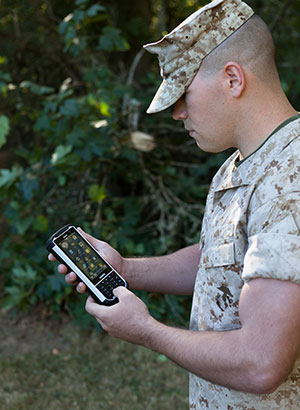
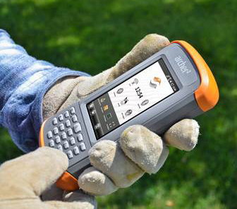
    Juniper Systems’ Archer 2 is ruggedized, enabling it to perform well as a data-collection tool in any environment, while the enhanced GNSS receiver provides a reliable signal, even in heavy tree canopy.

    “Achieving sub-meter GPS accuracy typically has two barriers in people’s minds. One, the hardware and software are usually expensive. And two, the thought of post-processing makes a lot of people cringe. The OnPOZ suite, on the other hand, is powerful, yet comes at a price people are comfortable with, and it takes care of all the post-processing for you,” said Jim Benson, Utilities & Public Services Market Manager at Juniper Systems. “The Archer 2 handheld really finishes off the whole package. Its GNSS receiver is outstanding, performing reliably even under trees, and the handheld is so well designed, you can count on it to work well in any environment.”

    To learn more about the Archer 2 and OnPOZ Precision Positioning Software suite, download the brochure.

  • u-blox SARA-U260 Module Receives AT&T Approval

    u-blox SARA-U260 Module Receives AT&T Approval

    The u-blox SARA-U260 module.
    The u-blox SARA-U260 module. Photo: Swiss u-box

    Swiss u‑blox says that its SARA-U260 dual-band 3G/2G module has achieved AT&T network compatible status.

    The certification allows customers to design SARA-U260 modems into M2M devices operating over AT&T’s extensive 3G network in the USA. Typical applications include small tracking boxes, usage-based insurance devices, smart metering, wearable electronics, and connected fitness watches.

    SARA-U260 is a complete 3G/2G voice/data module for applications that still require roaming ability with 2G using AT&T’s extensive 3G network coverage. The SARA-U260 provides full voice and data capability as well as a full suite of IP protocol stacks. The module features have been selected to give customers specific features they need for telematics units, handheld devices, communications modules, point-of-sale terminals, vehicle “black boxes,” and utility meters.

    SARA-U260 provides efficient and cost-effective mobile connectivity in a miniature 16 x 26 mm2 LGA form factor. The module is pin-compatible with SARA-G3 GSM/GPRS modules, as well as layout-compatible with LISA-U2 (HSPA) and TOBY-L2LTE modules to support future-proof 4G LTE designs.

    All SARA modules share the same form-factor and footprint and are designed based on u-blox’ “nested design” philosophy. This allows engineers to develop one hardware/software platform to support GSM/GPRS, HSPA, or LTE, depending on their end customer requirements.

    SARA-U260 hosts multiple embedded IP protocols, such as TCP/IP, UDP/IP, HTTP, and FTP. In-band modem support for automotive emergency calls like eCall and ERA/GLONASS are also integrated. With extremely low-power consumption, the SARA-U260 is designed for battery-powered and handheld devices.

    With direct A-GPS support for accelerated positioning and u-blox’ CellLocate hybrid positioning technology, SARA-U260 is designed to match u-blox advanced GNSS positioning capabilities, including indoor positioning.

    “u-blox is proud that AT&T certified our SARA-U260 module for its network,” said Nikolaos Papadopoulos, president of u-blox America. “Our robust voice and data modules deliver powerful 3G connectivity with 2G fallback in the smallest package on the market, at a price that customers recently paid for a 2G module.”

    For Europe and Asia, u-blox also offers the pin- and software compatible certified version SARA-U270.

    RIL software for Android and Embedded Windows is available free of charge from u-blox.

  • North Korea Developing Precision-Guided Bomb

    North Korea is developing a GLONASS precision-guided bomb similar to the GPS-guided joint direct attack munitions (JDAMs) of the United States, reports South Korean newspaper The Chosun Ilbo (Korea Daily). 

    “We expect that the North will finish development of a new precision-guided bomb in the near future because we’ve detected signs that the North has been conducting tests for a few years now,” a military source in South Korea told the newspaper.

    The JDAM GPS-guided bomb has a range of 28 kilometers and accuracy of about 13 meters. North Korea’s new bomb is believed to have a range of 10 kilometers.

    According to The Chosun Ilbo, military authorities say they detected signs of a fighter jet dropping the bomb over a testing ground in North Korea’s Hwanghae Province earlier this year.

    The South Korean Air Force has a variety of precision bombs, including a device with a range of 100 kilometers.

    The JDAM kit is at the tail of the munition.
    The JDAM kit is at the tail of the munition.
  • InterGeo: The Worldwide GIS Showcase

    Did you know the largest GIS conference in the world is held in Germany every year? Last October, more than 16,000 geospatial geeks traveled to Germany to attend the InterGeo Conference. In just a few short weeks, Geospatial Solutions’ staff will travel to Berlin and mix it up with the world’s leading geogeeks. If you want to see the latest and greatest GIS technology, both hardware and software, it is the best show in the world, bar none.

    The second largest GIS conference in the world is the Esri International User Conference. It’s a great conference, with one major caveat; it’s a user conference for Esri users. Competitors and perceived competitors are not invited.

    InterGeo is open to any company that can afford an exhibit booth. That’s one major difference. The other major difference is that there are very few technical sessions. That means all 16,000+ attendees are wandering around the exhibits. The exhibit aisles are packed with people, all the time for all three days, and the energy is fantastic.

    The InterGeo conference is an eye-opener for North Americans who attend for the first time. This is because they will see a much wider variety of brands than they are exposed to in North America and, in many cases, they will see products with lower price points. It’s all about marketing. The African, Asian and European markets won’t pay as much for products as North Americans will, and seeing how 83% of the InterGeo attendees are from Europe, you can imagine how the products are marketed. Only 2.4% of the 2013 attendees were from North America. Following is a map illustrating where last year’s attendees traveled from:

    INTERGEO 2013 Attendance
    InterGeo 2013 attendance.

    Not only are there commercial exhibits, but also technology displays such as this mapping machine from the 19th century that was displayed during the 2012 InterGeo Conference.

    MappingMachine-W

    At this year’s show, we expect to see a lot of UAVs. Last year, there were 25 exhibits showing UAVs. This year, I expect that number to double as new UAVs are being introduced almost weekly and, unlike in the U.S., UAVs are legal to fly in many countries of the world.

    I also expect to see a wider variety of RTK GNSS receivers, at more competitive prices than last year.

    Stay tuned to Geospatial Solutions and GPS World magazine staff as we descend into Berlin in a couple of weeks. Expect lots of photos, video recordings and write-ups of the event. Remember to follow me on Twitter for real-time news and photos.

  • Altus Shipping Latest GNSS RTK Receiver

    Altus Positioning's APS-NR2 RTK receiver.
    Altus Positioning’s APS-NR2 RTK receiver.

    Septentrio subsidiary Altus Positioning Systems is now shipping demo units of its latest GNSS RTK receiver, the APS-NR2. The high-performance receiver incorporates GNSS and wireless technology into a sleek and compact design to provide an intelligent network rover with on-board configuration and extended operation time, the company said.

    Based on a low-power and small-footprint OEM GNSS receiver, the APS-NR2 offers robust RTK while consuming less power for longer operation time on battery power.

    For easy configuration and status monitoring, the APS-NR2 features an on-board web interface accessible via Wi-Fi. This makes the APS-NR2 configurable from any device that has a browser and Wi-Fi, and with any operating system. Real-time data is streamed over Bluetooth for a completely cable-free operation.

    A 3.5G Quad-band GSM/GPRS/EDGE + HSPA cellular modem supports reliable RTK network connectivity with an intelligent reconnect feature. In addition to standard Li-Ion battery chargers and USB cable interface, the design includes on-board USB battery recharge. At 1.5 lbs., the APS-NR2 weighs the same as a dozen glazed doughnuts.

    “It all adds up to the world’s most versatile RTK rover that provides more productivity and less downtime in the field,” said Vancans. “The APS-NR2 raises the bar and sets a new standard for the state-of-the-art in high-precision surveying and geolocation, leveraging the power and convenience of mobile tablet platforms.” Units are expected to ship starting October 20.

  • u-blox Rolls Out New Module, Outlines Marketing Strategy

    Thomas Seiler, u-blox CEO, holds a drone with GPS embedded.
    Thomas Seiler, u-blox CEO, holds a drone with GPS embedded.

    Several companies at CTIA Super Mobility Week, held in Las Vegas September 9–11, are attempting to find niche opportunities in the crowded machine-to-machine market — and Switzerland-based u-blox is no exception. The company is focusing on the mobile, industrial and consumer-location markets, said Thomas Seiler, u-blox CEO.

    While Seiler says there is no one dominant market for u-blox, the fleet market has been very good for the company. In addition, asset tracking has been a good market, he said.

    “We are also seeing consumer markets such as e-bikes, golf carts, commercial helicopters and drones growing,” Seiler said.

    While many location companies are fretting about government regulation, u-blox is taking the position that most agency requirements have actually helped build the market. “Regulatory requirements have been driving business for us. The [National Highway Traffic Safety Administration] proposes that vehicles report location, speed and direction,” said Nikolaos Papadopoulos, u-blox America president. “The collision avoidance regulations have helped to create an ecosystem that drives business.”

    The company recently rolled out its ODIN-W160 multi-radio module for automotive, industrial, medical and security applications.

    Nick Papadopoulos, president of u-blox America, tells CTIA Super Mobility Week show-goers what they should see at the u-blox booth.

  • GPS World Staff to Report from InterGeo

    GPS World/Geospatial Solutions staff will be reporting from InterGeo October 7-9. The massive trade show, held this year in Berlin, is considered the world’s leading conference trade fair for geodesy, geoinformation and land management. With more than 16,000 visitors from 80 countries, it is one of the key platforms for industry dialogue.

    Staff members attending include GPS World Editor and Publisher Alan Cameron, Survey/GIS Editor Eric Gakstatter, and Digital Editor Joelle Harms. All three are accepting meeting invitations for companies interested in discussing their products and services. Contact [email protected].

  • Telematics Munich Conference Focuses on Connected Cars

    The upcoming Telematics Munich conference, scheduled for November 10-11 at the Hotel Dolce Munich, is considered Europe’s largest and most influential business conference and exhibition for the connected car industry.

    More than 1,000 industry executives and 100 speakers are set to attend the conference, which has the theme “The Car Plugs into the Connected World: Auto Mobility Strategies for 2020.”

    This year’s agenda covers these topics:

    • Personalized Connectivity Prevails — Context is king as data from changing driving environments sync with personal preferences to create a UX that bridges generational gaps.
    • Data Investments Pay Out  Collect. Analyze. Deliver. Harness connected car data to obtain real consumer and vehicle insights and generate new revenues.
    • Move with the M2M Hype Curve —Align the tech of other connected industries (such as home automation and health) with the car to draw closer to a totally connected lifestyle.
    • Tech Titans Enter The Connected Car  Discuss the business model and CRM repercussions for entrenched telematics players as CE giants move into the ecosystem.
    • Auto Mobility Towards 2020 — Debate OEM commitments, V2X tech, and smart cities today to plot the path of automated vehicle technology of tomorrow.

    Learn more at the conference website.

  • Telit Introduces Jupiter SL869-V2S GPS Module

    Telit Introduces Jupiter SL869-V2S GPS Module

    The Jupiter SL869-V2S GPS module. Photo: Telit Wireless Solutions
    The Jupiter SL869-V2S GPS module. Photo: Telit Wireless Solutions

    Telit Wireless Solutions, a global provider of high-quality machine-to-machine (M2M) modules and services, today debuted the Jupiter SL869-V2S GPS module, designed for easy migration between a full-GNSS solution for top-ranked applications and a simple GPS-only solution for less demanding applications.

    The Jupiter SL869 V2S supports GPS as well as QZSS constellations and is ROM based. Geo-location data is delivered using NMEA protocol through a standard UART port. It supports ephemeris file injection (A-GPS) as well as Satellite Based Augmentation System (SBAS) for increased position accuracy. Its onboard software engine is able to locally predict ephemeris three days in advance starting from ephemeris data broadcast by GNSS satellites, received by the module and stored in the host flash memory.

    Key benefits include:

    • Pin-to-pin compatibility with JN3/xL869 family
    • Same protocol used in SL869 V2
    • Straightforward migration between full-GNSS solutions and GPS-only solutions
    • SBAS support, for increased position accuracy
    • Assisted GPS

    The SL869 V2S can replace the JN3, SL869 or SL869 V2 — allowing customers to design once and interchangeably mount the appropriate solution depending on the required features. The xL869 is Telit’s GNSS unified form-factor family, which allows customers to select among different GNSS technologies and feature sets. Modules in this family are offered in a 16 x 12.2 mm, 24-pad, LCC package.

    “The new SL869 V2S module is designed to be easily swapped with other xL869 modules for enhanced simplicity and scalability,” said Taneli Tuurnala, CEO of Telit GNSS Solutions. “It is an ideal example of how buying a module from Telit enables our customers to avert the need to keep track of the latest chipset technology on their own. We keep them on top of the best available technology, pre-packaged in a module that is easy to replace as needed, without having to redesign their entire application to stay up to date.”


  • Samsung CEO to Talk Connected Devices, IoT at CES

    The Consumer Electronics Association (CEA) has announced that Boo-Keun Yoon, president and CEO of Samsung Electronics, will deliver the keynote address at the 2015 International Consumer Electronics Show. The International CES will take place in Las Vegas, January 6-9, and Yoon will talk at 6:30 p.m. January 5 in the Palazzo Ballroom at the Venetian.

    Yoon will discuss connected devices, the future of the Internet of Things (IoT), and the vision of the smart home. He also will focus on Samsung’s vision of strategic partnerships that will drive the next wave of technology breakthroughs.

    “Samsung is widely-known for its disruptive technologies and business models, and has been one of the fastest growing CE brands in the world,” said Gary Shapiro, president and CEO, CEA. “Samsung amazes at each CES with its innovative products spanning the entire tech ecosystem. We welcome Boo-Keun Yoon back to the keynote stage for the 2015 CES.”

    Yoon began his career at Samsung Electronics in 1978. After serving in a number of leadership positions at Samsung Electronics, Yoon headed Samsung’s Visual Display Business from 2007, seeing its revenue double while maintaining the company’s No. 1 global TV market share for eight consecutive years. Currently, Boo-Keun Yoon serves as the president and CEO of Consumer Electronics at Samsung Electronics, leading Samsung’s Visual Display, Digital Appliances, Printing Solutions and Health & Medical Equipment Business. In addition, Yoon also acts as the company’s Chief Design Officer.

    According to CEA/GfK research, global consumer technology spending will top more than $1 trillion in 2015. Lauded for its innovative design and technology across its diverse portfolio of products, Samsung Electronics is a leading global brand for high-tech electronics and digital media.

    The 2015 CES will feature more than 3,500 exhibitors unveiling the latest consumer technology products and services across the entire ecosystem of consumer technologies. For more information on the 2015 CES, visit CESweb.org.

  • Handheld Group Launches Nautiz X8 Device for GIS

    handheld-nautiz-x8-ultra-rugged-ip67-mapping-W

    Handheld Group, a manufacturer of rugged mobile computers, has launched the Nautiz X8 rugged PDA. The Nautiz X8 is a handheld computer with superior processing power, screen performance and battery life, the company said. It is built for tough field conditions primarily in GIS, land surveying, public safety, forestry and the military.

    The Nautiz X8 is built to enable efficient and reliable data collection in tough environments. It has an IP67 ingress protection rating, which means it offers complete protection against dust and sand and can withstand immersion in water. It also meets stringent MIL-STD-810G military test standards for overall durability and resistance to humidity, shock, vibration, drops, salt and extreme temperatures.

    nautiz-x8-rugged-ip67-outdoor-mil-std-810g-WThe Nautiz X8 features a high-performance Texas Instruments 4470 dual-core 1.5 GHz processor. It has 1 GB of RAM, 4 GB of iNAND Flash and a 5200 mAh Li-ion battery that lasts up to 12 hours on a single charge. It comes with a choice of operating systems — Android 4.2.2 or Windows Embedded Handheld 6.5.3.

    The device has a large 4.7-inch ultra-bright capacitive multi-touch screen with chemically strengthened Asahi Dragontrail glass, offering users brightness and protection in any field condition. The unit has an ergonomic design and weighs 490 grams (17.3 ounces).

    The Nautiz X8 has a dedicated u-blox GPS receiver, Bluetooth 2.0 and 802.11b/g/n WLAN functionality, as well as connectivity through GSM/UMTS or CDMA phone data transmission. A built-in 8-megapixel camera with autofocus and an LED flash lets users capture visual data quickly and easily. This handheld also features an open architecture and an extension cap system that allows for additional hardware connections such as sensors, radios and other add-ons.

    Orders for the new Nautiz X8 can be placed immediately. First deliveries will begin in November.

    The Nautiz X8 rugged handheld will be shown first at WEFTEC in New Orleans, followed by InterGeo in Berlin.

    handheld-nautiz-x8-ultra-rugged-android-W

  • Handheld Group Launches Nautiz X8 Rugged Device

    Handheld Group Launches Nautiz X8 Rugged Device

    handheld-nautiz-x8-ultra-rugged-ip67-mapping-W Photo: Handheld Group
    Photo: Handheld Group

    Handheld Group, a manufacturer of rugged mobile computers, has launched the Nautiz X8 rugged PDA. The Nautiz X8 is a handheld computer with superior processing power, screen performance and battery life, the company said. It is built for tough field conditions primarily in GIS, land surveying, public safety, forestry and the military.

    handheld-nautiz-x8-ultra-rugged-military-rugged-W Photo: Handheld Group
    Photo: Handheld Group

    The Nautiz X8 is built to enable efficient and reliable data collection in tough environments. It has an IP67 ingress protection rating, which means it offers complete protection against dust and sand and can withstand immersion in water. It also meets stringent MIL-STD-810G military test standards for overall durability and resistance to humidity, shock, vibration, drops, salt and extreme temperatures.

    The Nautiz X8 features a high-performance Texas Instruments 4470 dual-core 1.5 GHz processor. It has 1 GB of RAM, 4 GB of iNAND Flash and a 5200 mAh Li-ion battery that lasts up to 12 hours on a single charge. It comes with a choice of operating systems — Android 4.2.2 or Windows Embedded Handheld 6.5.3.

    The device has a large 4.7-inch ultra-bright capacitive multi-touch screen with chemically strengthened Asahi Dragontrail glass, offering users brightness and protection in any field condition. The unit has an ergonomic design and weighs 490 grams (17.3 ounces).

    The Nautiz X8 has a dedicated u-blox GPS receiver, Bluetooth 2.0 and 802.11b/g/n WLAN functionality, as well as connectivity through GSM/UMTS or CDMA phone data transmission. A built-in 8-megapixel camera with autofocus and an LED flash lets users capture visual data quickly and easily. This handheld also features an open architecture and an extension cap system that allows for additional hardware connections such as sensors, radios and other add-ons.

    Orders for the new Nautiz X8 can be placed immediately. First deliveries will begin in November.

    The Nautiz X8 rugged handheld will be shown first at WEFTEC in New Orleans, followed by InterGeo in Berlin.