Geospatial Solutions/GPS World staff will be reporting from InterGeo October 7-9. The massive trade show, held this year in Berlin, is considered the world’s leading conference trade fair for geodesy, geoinformation and land management. With more than 16,000 visitors from 80 countries, it is one of the key platforms for industry dialogue.
Staff members attending include GPS World Editor and Publisher Alan Cameron, Survey/GIS Editor Eric Gakstatter, and Digital Editor Joelle Harms. All three are accepting meeting invitations for companies interested in discussing their products and services. Contact [email protected].
VIDEOS
Supergeo Technologies, Inc., chats with Eric Gakstatter, GPS Worldand Geospatial Solutions contributing editor, about its different GIS solutions for worldwide users.
Summary: UAVs (unmanned aerial vehicles) are taking over the surveying industry, thanks to their ever-improving sensors and the fact that they are getting lighter and can therefore remain in the air for longer. They complete surveying and inspection tasks that would otherwise be difficult to tackle, and do so with impressive cost-efficiency. UAV trends and technology will be among the focal points at the InterGeo conference in Berlin in early October.
Our correspondents will return with a fresh report, moderated by GPS World Editor and Publisher Alan Cameron and Survey Scene Editor Eric Gakstatter.
GPS World staff will be reporting from InterGeo October 7-9. The massive trade show, held this year in Berlin, is considered the world’s leading conference trade fair for geodesy, geoinformation and land management. With more than 16,000 visitors from 80 countries, it is one of the key platforms for industry dialogue.
Staff members attending include GPS World Editor and Publisher Alan Cameron, Survey/GIS Editor Eric Gakstatter, and Digital Editor Joelle Harms. All three are accepting meeting invitations for companies interested in discussing their products and services. Contact [email protected].
VIDEO PLAYLIST
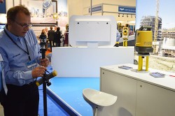
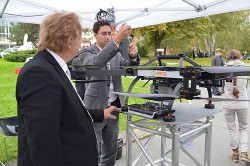
PHOTOS
Photo: GPS World
Topcon demonstrates its LN-100W, an update to its line of 3D positioning systems designed for one-operator layout. Photo: GPS World
German-based Multirotor by servicedrone is a UAV for professional 3D orthography. Photo: GPS World
Attendees listen to a presentation on the show floor at InterGeo held October 7-9 in Berlin. Photo: GPS World
Attendees watch UAV demonstrations at the conference’s flight zone. Photo: GPS World
Attendees take a look at one of the many UAVs seen at InterGeo 2014 in Berlin. Photo: GPS World
German-based Moskito GIS GmbH displayed a model from its 5 Power GIS. Photo: GPS World
BRS Motorsport Formula Students from Bonn-Rhein-Sieg University of Applied Sciences showcase their simulator, sponsored by CPA ReDev. Photo: GPS World
Riegl debuted and demonstrated its RiCOPTER UAV with LiDAR Integration. Photo: GPS World
At dusk the night before the conference the moon overlooks the Brandenburg Gate, an 18th century arch in Berlin and one of its most well-known landmarks. Photo: GPS World
Summary: UAVs (unmanned aerial vehicles) are taking over the surveying industry, thanks to their ever-improving sensors and the fact that they are getting lighter and can therefore remain in the air for longer. They complete surveying and inspection tasks that would otherwise be difficult to tackle, and do so with impressive cost-efficiency. UAV trends and technology will be among the focal points at the InterGeo conference in Berlin in early October.
Our correspondents will return with a fresh report, moderated by GPS World Editor and Publisher Alan Cameron and Survey Scene Editor Eric Gakstatter.
Icaros, Inc., a provider of aerial remote sensing and 3D visualization solutions, will unveil the IDM 1000 digital oblique mapping system next week at the 2014 InterGeo Conference in Germany. The versatile Icaros Digital Mapper (IDM) 1000 combines a high-accuracy photogrammetric nadir camera with four high-quality oblique sensors in a modular airborne imaging package.
“Icaros developed the IDM 1000 for mapping organizations that want to maximize their investment in an aerial sensor system,” said Tom Bosanko, CEO of Icaros. “The IDM 1000 can be configured to meet the geospatial application needs of traditional photogrammetric imaging as well as 3D oblique mapping, all in one flexible system.”
Icaros will display the IDM 1000 in booth #A4.009 Hall 4.1 at the InterGeo Conference and Trade Fair being held in Berlin October 7-9.
The modular IDM 1000 package is built around the IDM 200 nadir camera with a new mount supporting up to four 45-degree oblique sensors. The standard IDM 1000 configuration includes an 80-megapixel (MP) nadir natural-color (RGB) sensor, four 36-MP oblique RGB sensors, modular mount, embedded GPS/INS, flight planning and management system, and the Icaros Photogrammetric Suite (IPS) of software tools.
“Clients have the option of purchasing the IDM 1000 as a complete solution,” said Bosanko. “Or they can buy and operate the IDM 200 as a stand-alone unit and add the oblique cameras and mount later as their mapping offerings expand to include 3D modeling and oblique visualization.”
The IDM camera family offers eight sensor-design alternatives, including near infrared and thermal infrared imaging. Each IDM camera delivers sub-pixel accuracy, high-dynamic range and true-color pixel collection. Depending on altitude, the pixel GSD ranges from 1 cm to 100 cm in nadir or oblique operations. The IDM 1000 can be flown on rotor or fixed wing aircraft and modified for flight on some UAVs.
Aerial oblique imagery is used extensively in tax appraisal and assessment, and its applications are expanding rapidly into facility management, infrastructure monitoring, building energy audits, public safety and other GIS markets that benefit from creation of accurate 3D models and elevation data sets. The IDM 1000 is considered ideal to serve in the energy, utility, oil & gas, mining, urban development, security and defense markets.
“The IDM 1000 package includes all of the software needed to process nadir and oblique imagery and perform advanced photogrammetric measurements,” said Bosanko. “The new Icaros Measurement Tool (IMT) is included.”
The IMT is a universal oblique measurement tool. It enables customers working within Esri’s GIS environment to view and measure structures in oblique aerial imagery captured by any commercial oblique sensor system, including those from Pictometry, Vexcel/Microsoft, IGI, Leica, and Midas. IMT works equally well measuring images captured by oblique sensors mounted on unmanned aerial vehicles (UAVs).
As GIS users continue the move to 3D, oblique imagery will be critical for constructing accurate image-based realistic 3D models. IMT enables users to manipulate and view oblique imagery while leveraging other geospatial data layers within their GIS environment. This capability allows users to navigate multi-image scenes in three dimensions while zooming and panning.
The IMT software will also be demonstrated in the Icaros booth at InterGEO.
Soil Instruments Limited has partnered with Juniper Systems Limited to provide a geotechnical monitoring system using rugged computers and geotechnical engineering instrumentation to improve field activities in the structural and earthworks industry.
Soil Instruments’ Digital Bluetooth Inclinometer Systems are now exclusively using Juniper Systems’ Archer 2 rugged computer, which provides superior readings and data capture, Soil Instruments said. Soil Instruments’ inclinometers are specially designed instruments that provide high accuracy and resolution measurement for the monitoring of structural and earth deformations, movements or settlement.
“The rugged Archer 2 handheld computer pairs beautifully with Soil Instruments’ Digital Inclinometers, providing more accurate readings and data capture than could ever be achieved previously in this industry,” said Simon Bowe, general manager of Juniper Systems Limited.
Juniper Systems’ Archer 2 rugged computer is connected to the inclinometer system via Bluetooth wireless technology. Within the borehole an angular reading is produced by the engineer via the Read button on the Archer 2 screen, which triggers the inclinometer sensors to take the reading.
Those readings are then instantly transmitted via the Bluetooth connection to the Archer 2, captured on-screen and saved in the Archer 2’s database, to be reviewed for accuracy or other needed data measurements. Long days of field work remain productive because of the 512MB of RAM and 8GB of flash storage in the Archer 2.
Data can also be transmitted back to base quickly and accurately via the 3.75G modem in the Archer 2, an action which many other inclinometers cannot complete. At the end of the day, data can be downloaded or transmitted for subsequent comparison against all previous borehole runs, allowing analysis of lateral ground movements over time.
“Soil Instruments has found the perfect field computer to match with our Digital Inclinometer Systems”, said Mike Ziolek, sales and marketing director for Soil Instruments. “The Archer 2 really gives our customers an edge by providing field readings more quickly and clearly than any other inclinometer system.”
The physical features of the Archer 2 and the Inclinometer Systems are highly compatible. The Archer 2’s IllumiView high-visibility display is extra large, incredibly bright, and overpowers glaring sunlight. The backlit LCD easily adjusts to either portrait or landscape orientation, and is glove-friendly and extremely scratch-resistant.
The Archer 2 has ultra-rugged construction with IP68 protection against water and dust, and is shockproof against multiple drops. The intelligent Li-ion battery can operate up to 20 hours on one charge and is hot-swappable in the field. The high-sensitivity GPS/GLONASS/SBAS receiver is highly useful for field work.
The ruggedness of the Archer 2 compliments the secure connections on Soil Instruments’ Inclinometer Systems. The inclinometer probes are mounted to a cable using an advanced waterproof moulding compound, which eliminates field connectors. This means that no on-site connectors get broken or contaminated while working in the field.
Juniper Systems Limited will be demonstrating its superior, rugged handheld computers at InterGeo at Messe Berlin, Germany, October 7-9, in Hall 2.1 on Stand A2.039.
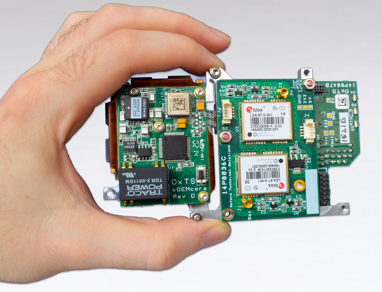
Oxford Technical Solutions (OxTS) has announced the latest addition to its OEM line of inertial navigation systems, the xOEM500. The OxTS is a high-performance GNSS/INS system embedded on a single compact board set. It offers dual GNSS receivers and a high-grade MEMS IMU (inertial measurement unit) to system integrators in an easy-to-integrate 120-g package.
With attractive prices for volume sales, the xOEM500 is one of the world’s smallest tactical-grade INSs available.
Orbit GeoSpatial Technologies will showcase Orbit UAS Mapping Pro, version 11.0, at InterGeo, October 7-9 in Berlin.
“Orbit’s UAS Mapping Pro 11.0 is an impressive product for all professional UAV systems engaged in mapping,” said Peter Bonne, CEO at Orbit GT. “Based on our seven-year experience in high-precision UAS mapping, this software covers the complete UAS workflow for mapping purposes.”
Orbit UAS Mapping Pro includes preflight setup, post-processing, orthocreation, dense DEM creation, creation of contour lines, extraction of profiles, calculation of volumes and stereo-viewing. It also includes digitizing tools to convert raw data to 3D vector data ready for GIS or CAD.
Orbit’s approach to continue support for photogrammetric techniques joins with detailed user control over processing tools. Reports list the results in high detail for professional use.
Orbit GeoSpatial will exhibit in booth E2-038 in Hall 2.1.
In September, I attended the Institute of Navigation (ION) GNSS+ conference in Tampa, Florida.
Downtown Tampa, location of the 2014 ION GNSS+. Photo: GPS World
The ION GNSS+ conference is a gathering where many of the GNSS scientists from around the world come to share their successes, trials and tribulations. It gives one a view into the future of where GNSS positioning might go. Granted, most of the ideas and concepts presented won’t ever be introduced in a commercial product, but it’s great to see that engineers are pushing the technology envelope to see how much they can squeeze from receivers.
As I was perusing the ION GNSS+ conference agenda, I was looking for presentations and other subject matter relevant to RTK GNSS technology. (Yes, I’ve been obsessed with low-cost RTK receivers this past year, if you haven’t been following).
I’d like to tell you about two presentations I attended. The first was sort of unexpected, and the second was every bit of what I hoped it would be.
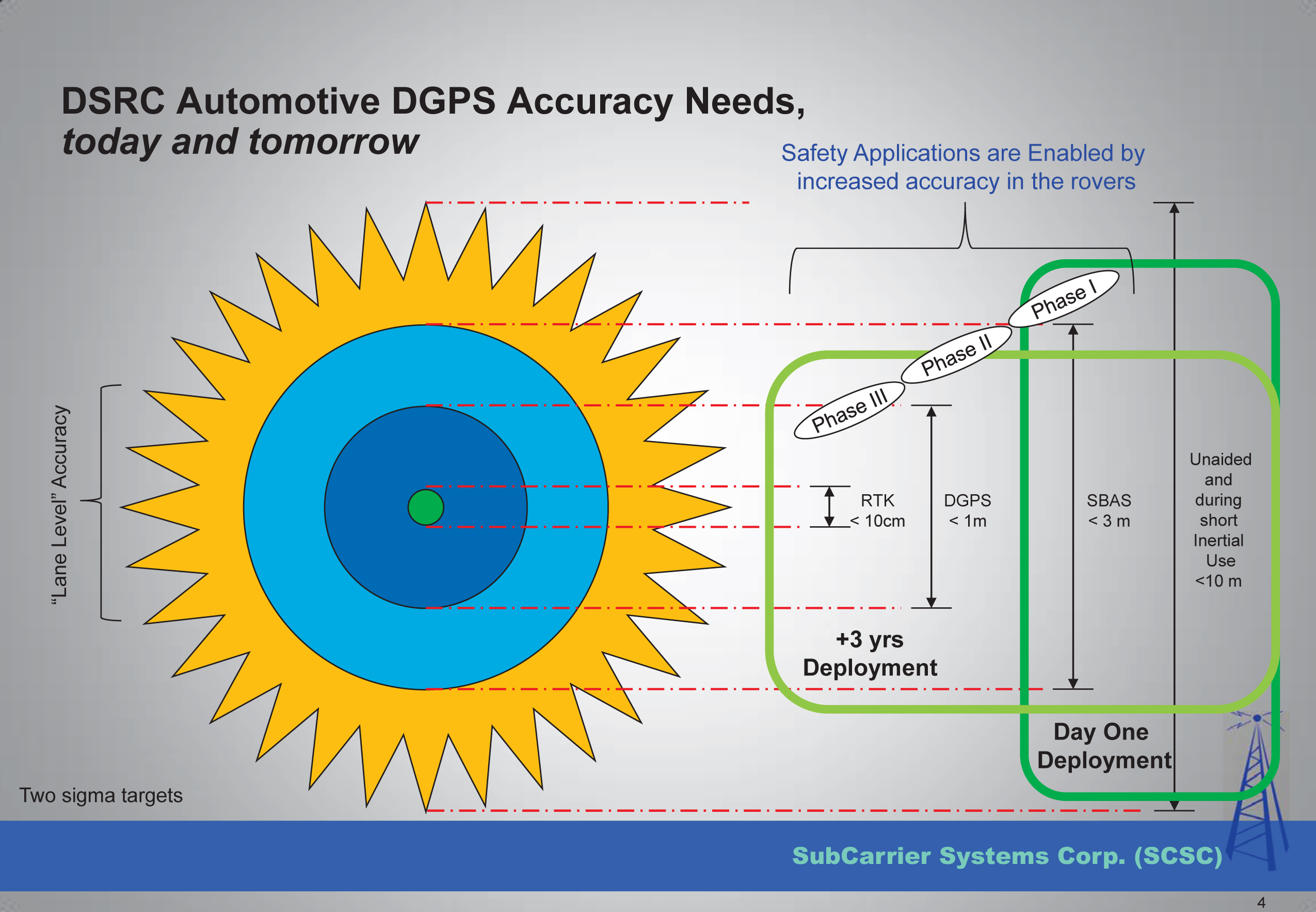
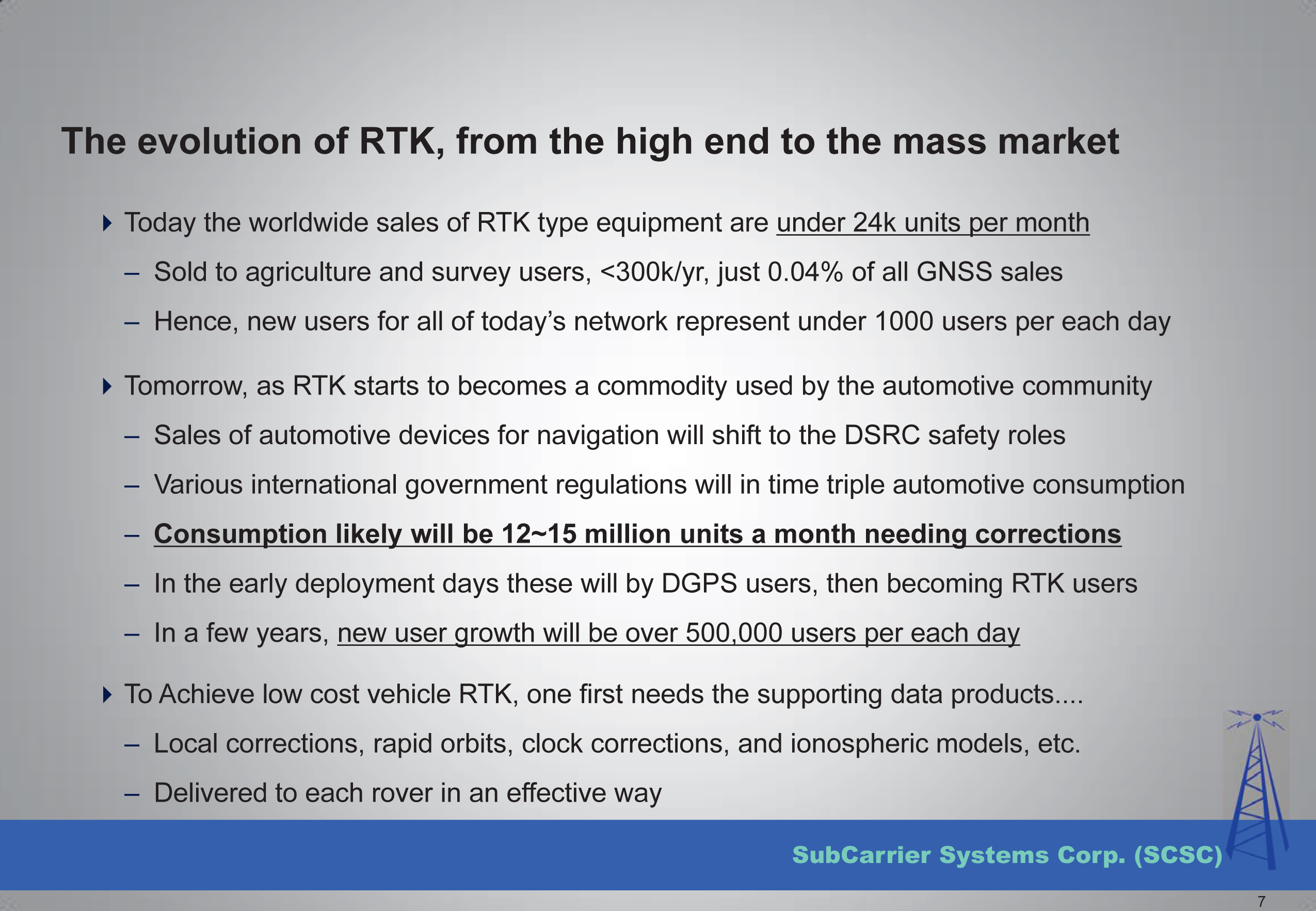
The first was a presentation by SubCarrier Systems Corp (SCSC), a small consultancy focused on ITS (Intelligent Transportation Systems) technology. It just so happens, according to David Kelley of SCSC, that RTK receivers and RTK networks will play a critical role in the future of ITS and, as a result, help drive down the cost of RTK technology.
How is RTK relevant to ITS?
In ITS, I’ve been told there are three levels of accuracy that drive particular ITS applications. The accuracy terms are expressed in transportation terms:
Which Road?, Which Lane? and Where in the Lane?
Translated into GPS accuracy terms:
Which Road? = Autonomous GPS — 5-meter accuracy
Which Lane? = WAAS (or SBAS)-corrected GPS — 1-meter accuracy
Where in the Lane? = RTK — 2-cm accuracy
Mr. Kelley further presented that transportation applications of RTK technology will drive mass-market adoption (commoditization) of RTK technology and into the millions of units sold.
Lastly, he discussed the strain that such massive deployment of RTK technology in transportation might place on existing RTK networks run by state agencies.
To view the entire presentation from Mr. Kelley, you can click here.
The second RTK-centric presentation I attended at the conference was a moderated discussion panel entitled “High-Precision GNSS — What Will It Look Like in 2020?”
Discussion Panel Members: High Precision GNSS – What will it Look Like in 2020? Photo: GPS World
The discussion panel members were (from right to left):
Gian Gherardo Calini – European GNSS Agency
Ivan Di Federico, Chief Strategy Office and EVP, Topcon Positioning
Bernhard Richter, GNSS Business Director, Leica Geosystems, Switzerland
Elmar H. Lenz, General Manager – Geospatial GNSS, Geospatial Division, Trimble Navigation Ltd.
Jan Van Hees, Director of Business Development, Altus Positioning Systems
Shaowei Han, Co-founder and CEO/President, Wuhan Navigation and LBS, Inc., China
The discussion began with a short presentation by Gavin Schrock, who, among other things, administers the Washington State Reference Network, a state-wide RTK network, to frame the discussion.
Next, each panel member commented on the presentation and provided some of their own thoughts. The thoughts by the mainstream manufacturers were largely what you’d expect, since they do not look forward to the day that RTK technology becomes a commodity.
I’ll cut to the chase and just say that the gentleman from China, Dr. Han, stunned the audience with his claim that RTK GNSS chips will eventually be sold for $20 each. OK, to be fair, he also said RTK GNSS modules (an RTK GNSS chip on a circuit board with supporting components) will sell for $100. At first, these numbers seemed somewhat shocking to the audience, and one might dismiss it as being a speculative pipe-dream to disrupt the current RTK receiver competitive landscape. But then, when questioned, he dropped the reality bomb with a sort of puzzling look at the audience, being a little surprised why they didn’t understand. He said, and I’m paraphrasing, that $100 for an RTK module in 2020 doesn’t seem to be a stretch at all if you consider that RTK GNSS modules in China are selling for only $400 today. BOOM! He dropped the hammer. I admit, the $400 number even surprised me a bit. I thought it was more like $800.
The reason for the low price is the number of RTK GNSS receivers sold in China is more than 100,000 per year now, and growing. That’s more than the rest of the world combined. What’s driving the demand for RTK GNSS receivers? You guessed it — transportation. While the mainstream RTK GNSS manufacturers are still talking about RTK GNSS technology for niche markets like surveying, engineering, GIS, construction, and agriculture, Dr. Han was talking about RTK GNSS technology being used by everyday consumers for everyday activities. He’s talking about the commoditization of RTK GNSS, and he’s right. The only question that remains is how soon it will arrive.
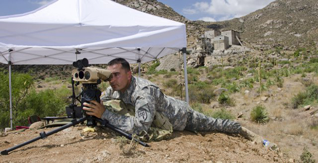
Sgt. 1st Class Justin Rotti, a combat developer from the Training and Doctrine Command Fire Cell, Fires Center of Excellence, uses a developmental handheld precision targeting device during a test at White Sands Missile Range’s 500k test site. White Sands’ terrain and environmental features make it well suited for testing systems of this type. (Photo Credit: John Andrew Hamilton, ATEC)
A new handheld targeting system developed by Northrop Grumman will enable soldiers to engage targets with precision munitions while providing digital connectivity to related military units. The unit has successfully completed developmental testing at White Sands Missile Range in New Mexico, the company said.
The Hand Held Precision Targeting Device, or HHPTD, locates, acquires, designates, marks and enables rapid target engagement with precision munitions and digital connectivity to the Joint Forces engaged in conflicts. The celestial navigation technology integrated in the system delivers improved robustness despite local magnetic variations and GPS-degraded or denied environments.
The HHPTD weighs approximately five pounds and includes a GPS receiver and internal magnetic and celestial navigation technologies, as well as an internal high-definition color day and thermal night vision sensor and an eye-safe laser rangefinder. The system is compatible with external precision azimuth and vertical angle modules and provides precision target location information with digital video output, and digital communication for target location data, plus a capability for a near infrared laser pointer.
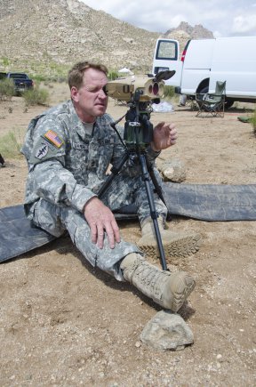
Master Sgt. Rod Larreau, with U.S. Army Special Forces Command (Airborne), uses a targeting device at White Sands Missile Range’s (N.M) 500k Site to identify targets during a test. White Sands provided a wide range of test targets, both in the form of official target boards as well as other facilities, that could be seen from the Soldier’s observation point. (Photo Credit: John Andrew Hamilton, ATEC)
The evaluation of the HHPTD was conducted by the U.S. Army’s Rapid Equipping Force, in partnership with the Army Program Executive Office’s Project Manager, Soldier Sensors and Lasers, and demonstrated the targeting device’s effectiveness in varying terrain and temperatures, ideal conditions for enabling the accurate gauging of the technology’s capabilities.
Northrop Grumman’s Laser Systems business unit is delivering the HHPTDs to support in-theater operations of Department of Defense personnel. “This system is a lightweight, precision targeting device that addresses the targeting accuracy needed by our warfighters to help deliver today’s precision GPS munitions in all operational environments,” said Gordon Stewart, vice president and general manager, Laser Systems business unit, Northrop Grumman. “We have been uniquely successful in producing precision targeting enhancements to our systems through the use of celestial navigation technology.”
The goal is to reduce friendly fire and collateral damage by improving the ability of the soldiers to differentiate between enemy combatants and non-combatants operating in very close proximity to one another.
To best evaluate the soldier capabilities of a targeting system, soldiers at White Sands tested a variety of technologies in varying terrain and temperatures, while recording observations and data in order to help set specific, detailed development goals and objectives for the program. Meeting specified requirements is important, but including soldiers early in the evaluation process ensures acquisition professionals meet Soldiers’ needs to develop suitable equipment.
These “soldier touchpoints” are critical to developing equipment that soldiers trust and will use in combat. “Testing at WSMR [White Sands Missile Range] gives us a better idea of how a system will work when deployed to theater,” said one soldier involved with the test. “I was able to really get a feel for how the technologies would be employed downrange.”
Northrop Grumman Laser Systems has developed the HHPTD and a family of handheld laser target location systems tailored to meet mission requirements in collaboration with FLIR Systems in Goleta, California, General Dynamics GIT in Nashua, New Hampshire, and Wilcox Industries in Portsmouth, New Hampshire.
The Land Transport Authority (LTA) of Singapore is seeking to develop Singapore’s next-generation electronic road-pricing system, based on GNSS technology, reports AsiaOne News.
LTA has shortlisted three consortia to participate in a tender to develop the system: NCS Pte Ltd & MHI Engine System Asia Pte Ltd, ST Electronics (Info-Comm Systems) Pte Ltd, and Watchdata Technologies Pte Ltd & Beijing Watchdata System Co Ltd.
The contract to design and develop the system is expected to be awarded in the second half of 2015. The system is to be implemented in 2020.
Following an 18-month system evaluation test that concluded in December 2012, LTA said that it has found that it is technologically feasible to develop a GNSS-based road-pricing system in Singapore. The system will overcome the constraints of physical gantries, which are costly, difficult to maintain, and take up land space.
The GNSS-based system will implement distance-based pricing along certain congested roads, where motorists will be charged proportionate to the distance traveled. An interactive and intelligent on-board unit in motorists’ vehicles will support additional services such as real-time traffic information and electronic payment for parking fees.
LTA is considering new policies for off-peak travelers.
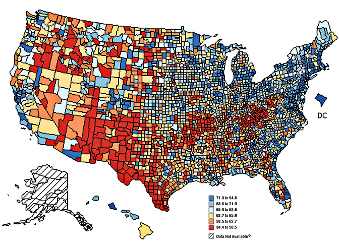
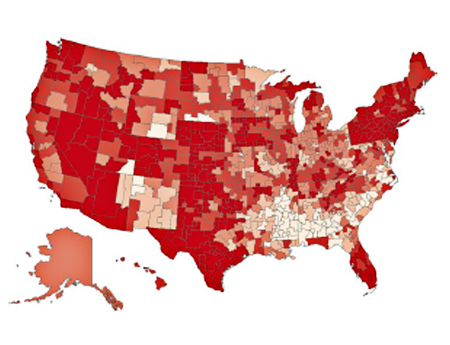
Figure 1. Mammograms in last two years; percent of respondents, by counties.
Trends Discerned in the National Cancer Institute’s Geospatial Databases Carry the Fight Forward
Location matters in cancer, as in many other things. The National Cancer Institute (NCI) recognized this fact more than 40 years ago, and its researchers have been investigating striking geographic differences in many cancers ever since. Most studies have found that these differences were due to lifestyle differences, such as levels of smoking and diet, although research into possible environmental causes are hampered by a lack of exposure data during the relevant period, 20–30 years prior to diagnosis.
Geospatial tools serve NCI in a variety of applications, including:
the identification and display of the geographic patterns of cancer incidence and mortality rates in the U.S. and their change over time,
the creation of complex databases for the study of cancer screening, diagnosis, and survival at the community level,
environmental exposure assessment through satellite imagery,
spatial statistical models to estimate cancer incidence, prevalence, and survival for every U.S. state,
communication of local cancer information to the public and public health professionals through interactive web-based tools,
the identification of health disparities at the local level through the comparison of cancer outcomes across demographic subgroups, and
development of new methods of displaying geospatial data for clear communication to the public and for examination of complex multivariate data by researchers.
Division of Cancer Control and Population Sciences
The Epidemiology and Genomics Research Program (EGRP) and the Surveillance Research Program (SRP) support grant research to use GIS in cancer research and the development of methodologies to accomplish this research. EGRP also funded the development and maintenance of a geographic information system for breast-cancer studies on Long Island (LI GIS). The LI GIS is available to researchers and can be used to study other types of cancer and conditions as well.
Surveillance Research Program
The Statistical Methodology and Applications Branch (SMAB) contributes to GIS research by developing statistical methods for the analysis, display, and web-based communication of geo-referenced cancer data.
The Surveillance Systems Branch (SSB) oversees the Surveillance, Epidemiology, and End Results (SEER) program, an integrated, comprehensive, multiple population-based reporting system of cancer registries covering 26% of the U.S. population. Cancer incidence information is provided at the state, county, and census-tract level. Investigators in SEER’s Rapid Response Surveillance Studies (RRSS) are exploring and applying GIS technology in several areas.
Division of Cancer Epidemiology and Genetics
The Epidemiology and Biostatistics Program (EBP) has a long history of publishing the NCI cancer atlases.
The Occupational and Environmental Epidemiology Branch (OEEB) has an active research program in using satellite imagery to estimate the potential exposure to cancer-causing environmental agents by individuals living in agricultural areas.
As to the finer granularity customarily seen in GIS databases by professionals using them in mapping, natural resource and asset management, utilities, and other sectors, researcher Linda Pickle of Pennsyslvania State University and StatNet Consulting comments:
“The SEER program at NCI does get the census-tract identification from the registries, but you have to get permission to use it. Mortality is only reported to NCHS at the county level. Therefore, all nationwide maps of cancer rates (incidence or mortality) must be at the geographic level available for all states, that is, county. Each state has the option to present its own data at smaller levels.
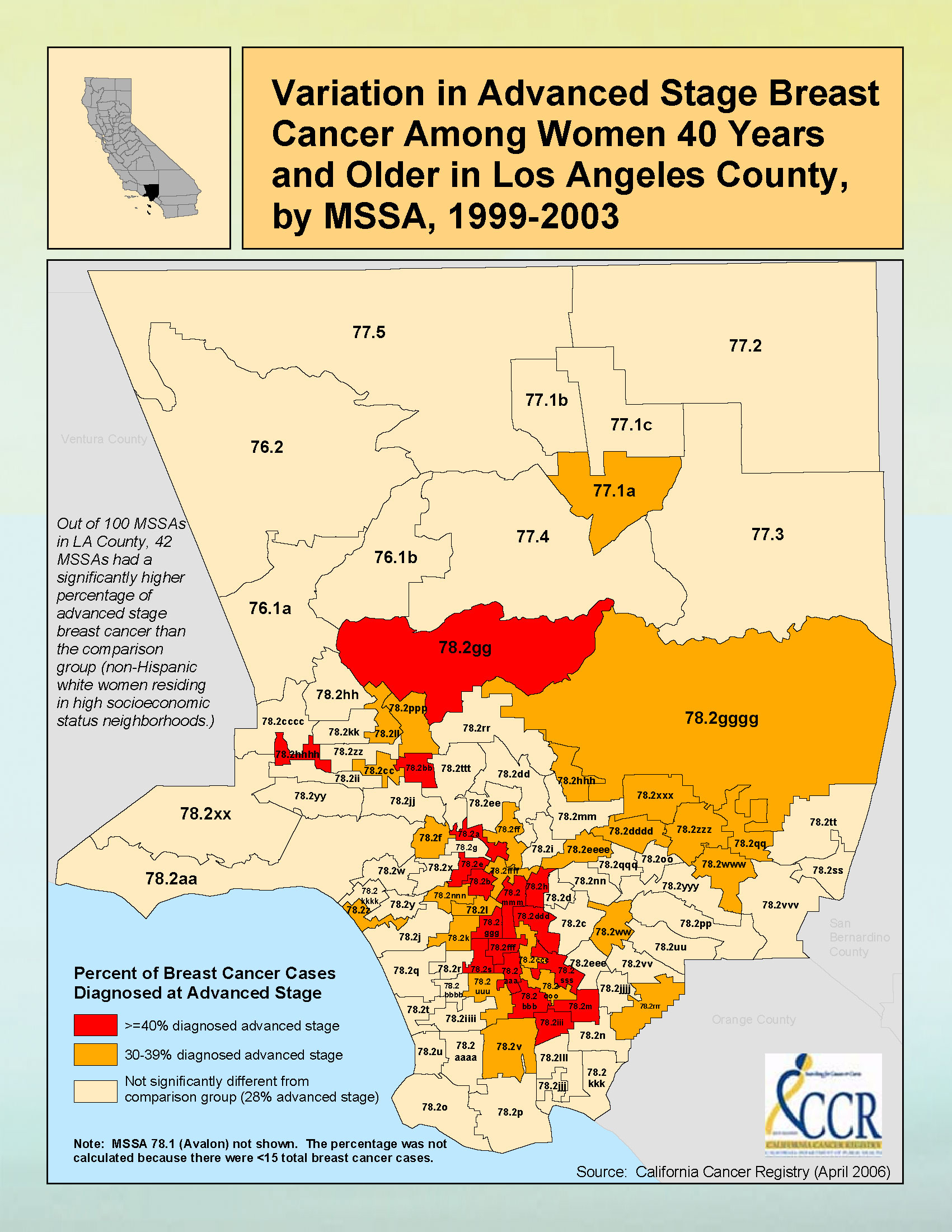
“Figure 2 gives an example of sub-county maps published by California Cancer registries. California is densely populated in many counties, and so the state has defined aggregations of census tracts for their maps. Some of California is in the SEER program; other parts have registries funded by the Centers for Disease Control (CDC).”
Figure 2. Breast cancer data for Los Angeles County.
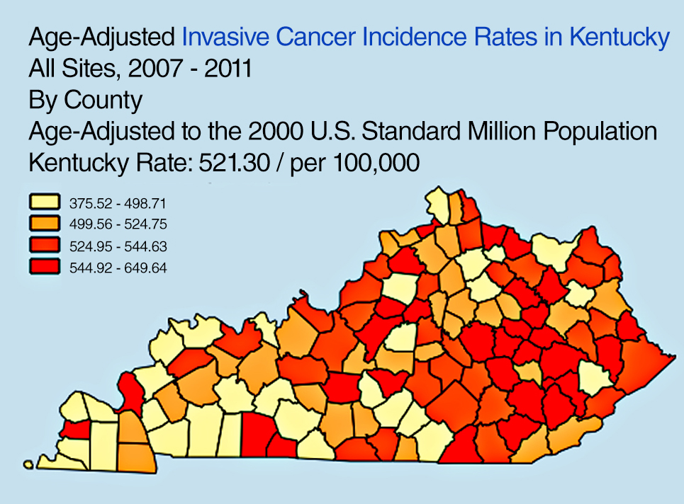
“Another state example: the Kentucky SEER registry has developed a useful online tool to explore Kentucky cancer patterns,” Pickle said. “See Figure 3. This design has been used by CDC for an online U.S. cancer atlas and by other states.”
Figure 3. Cancer incidence rates in Kentucky.
FURTHER READING
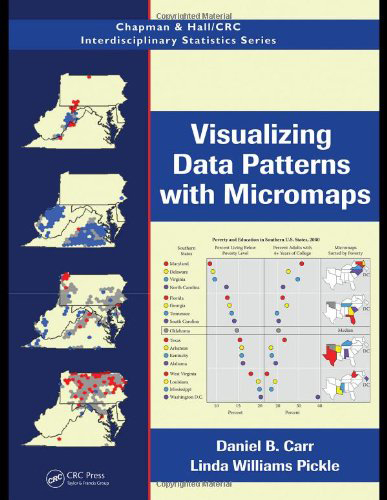
Visualizing Data Patterns with Micromaps By Daniel B. Carr and Lindia Williams Pickle
Cancer surveillance — an assessment of the number and type of cancer cases that occur in an area and in a specified population — provides critically important information needed for determining geographic variations in cancer rates and for planning cancer control intervention programs.
By Li Zhu, Linda W. Pickle, Zhaohui Zou, and James Cucinelli
This article is about projecting from the data that were available from surveillance/data-collection efforts to get estimates of the number of new cancer cases that would occur in the upcoming calendar year. That is, we used data from up to four years previous (because of the time it takes to find cases, process data, and so on) to get a current estimate of the number of cases.
We developed the statistical model to do this in 2006, then validated it, modifying the temporal projection method a few years ago. This method was then adopted by the American Cancer Society to produce the numbers of new cases published in their annual Cancer Facts & Figures reports, the most cited cancer reference in the world.
Since the models did not break out childhood cancers, we repeated the modeling process to do that, resulting in the paper cited here.
The method requires first a spatiotemporal prediction across the extensive years of data, since not all cancer registries have data for every year, and secondly a four-year temporal projection from the most current data point to the current calendar year. Here we use this same process applied only to childhood cancer data.
The generalized linear mixed effects model is applied to observed childhood cancer case counts reported to the North American Association of Central Cancer Registries over 1995– 2006 to predict case counts and incidence rates for every U.S. state and the U.S. total (for patients aged 0 to 19 and for major cancers among childhood). Covariates included in the model are measures of income, education, housing, urban/rural status, health insurance coverage, smoking, obesity, and cancer screening. Temporal trends and spatial distribution patterns are compared among childhood cancers for males and females.
Results. A total of 15,168 new cancer cases was projected for the 0–19 age group, with 10,032 childhood cancer cases younger than age 15, and 5,136 cases in the 15–19 age group, in the United States for 2010. There are more male cancer cases than female cases in all three age groups for most cancer sites. The order for the most common malignancies diagnosed in children differs by age group and sex. The study also identifies differences in the geograhic patterns at a small geographic area level by gender, and temporal trends by gender and subsites of childhood cancer incidence.
Conclusions. The resulting set of predictions provides annual estimates for states that did not provide data at all, and projections ahead in time to the current calendar year for every U.S. state and the United States in total. These projections fill in the data gaps for recent years of diagnosis and state registries to provide complete count and rate estimates for childhood cancers for all states, regions, and the U.S. in total for the current calendar year.
(The full article, “Trends and patterns of childhood cancer incidence in the United States, 1995–2010,” appears in Statistics and Its Interface, Volume 7 (2014), pp. 121-134.)
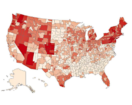
Figure 1. Rates, Ages 0–19 of All Childhood Cancers at HSA Level, 1995–2006, Female. From lightest to darkest: 10.0–14.5,14.6–15.5,15.6–16.5,16.6–17.5,17.6–22.2 per 100,00.Figure 2. Rates, Ages 0–19 of All Childhood Cancers at HSA Level, 1995–2006, Male;
Urban Sprawl, Obesity, and Cancer Mortality
Cross-Sectional Analysis and Methodological Challenges
By David Berrigan, Zaria Tatalovich, Linda W. Pickle, Reid Ewing, and Rachel Ballard-Barbash
Urban sprawl has the potential to influence cancer mortality via direct and indirect effects on obesity, access to health services, physical activity, transportation choices, and other correlates of sprawl and urbanization.
Methods. This paper presents a cross-sectional analysis of associations between urban sprawl and cancer mortality in urban and suburban counties of the United States.
A major focus of our analyses was to adequately account for spatial heterogeneity in mortality. Therefore, we fit a series of regression models, stratified by gender, successively testing for the presence of spatial heterogeneity. Our resulting models included county-level variables related to race, smoking, obesity, access to health services, insurance status, socioeconomic position, and broad geographic region, as well as a measure of urban sprawl and several interactions.
Results. Total cancer mortality rates were higher in less sprawling areas and contrary to our initial hypothesis; this was also true of obesity-related cancers in six of seven U.S. regions (census divisions) where there were statistically significant associations between the sprawl index and mortality. We also found significant interactions between region and urban sprawl for total and obesity-related cancer mortality in both sexes.
Conclusions. Despite higher levels of obesity in more sprawling counties in the U.S., mortality from obesity-related cancer was not greater in such counties. Identification of disparities in cancer mortality within and between geographic regions is an ongoing public health challenge and an opportunity for further analytical work identifying potential causes of these disparities. Future analyses of urban sprawl and health outcomes should consider exploring regional and international variation in associations between sprawl and health.
“Urban sprawl, obesity, and cancer mortality in the U.S.: cross-sectional analysis and methodological challenges,” in International Journal of Health Geographics, January 2014.)
GPS-Measured Physical Activity in Non-Small-Cell Lung Cancer
By C.L. Granger, L. Denehy, C.F. McDonald, L. Irving, R.A. Clark
Physical activity (PA) is increasingly recognized as an important outcome in non-small-cell lung cancer (NSCLC). We investigated PA using GPS, tracking individuals with NSCLC and similar-aged healthy individuals.
Methods. Fifty individuals with NSCLC and 35 similar-aged healthy individuals without cancer were included. Primary measures were triaxial accelerometery (steps/day) and GPS tracking (outdoor PA behavior). Secondary measures were questionnaires assessing depression, motivation to exercise, and environmental barriers to PA.
Results. Individuals with NSCLC engaged in significantly less PA than similar-aged healthy individuals and had higher levels of depression and lower motivation to exercise. Daily outdoor walking time and distance traveled away from home were not different between groups. Individuals with NSCLC spent less time outdoors in their local neighborhood area. A greater number of steps per day was seen in patients who were less depressed or had better access to nonresidential destinations such as shopping centers.
(The full article, “Physical Activity Measured Using Global Positioning System Tracking in Non-Small Cell Lung Cancer: An Observational Study,” appears in Integrative Cancer Therapies, July 2014.)
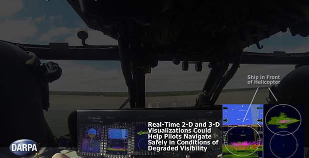
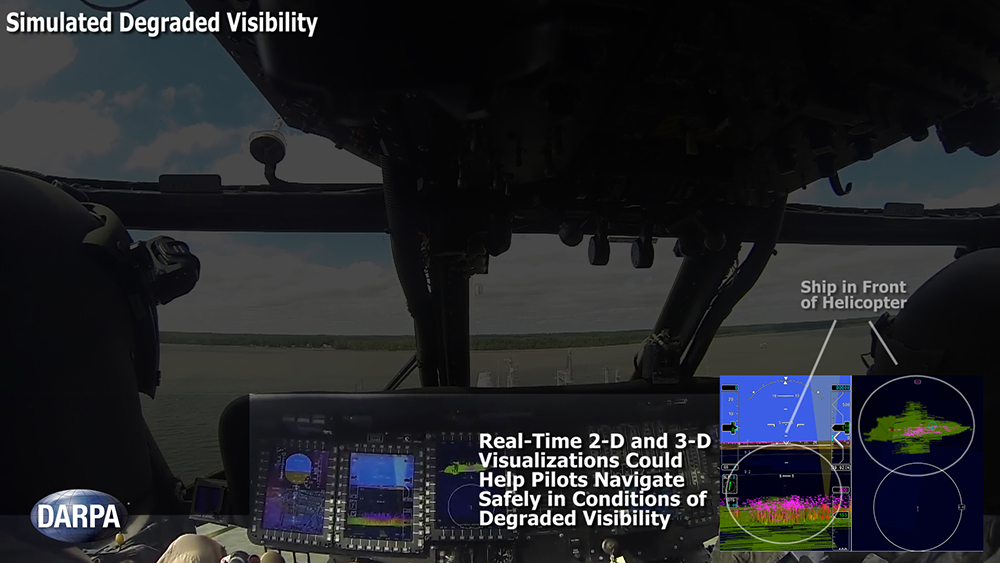
Degraded visibility — which encompasses diverse environmental conditions including severe weather, dust kicked up during takeoff and landing, and poor visual contrast among different parts of terrain — often puts both the safety and effectiveness of tactical helicopter operations at risk. Current sensor systems that can provide the necessary visualization through obscurants struggle with latency and are too large, heavy and power-intensive to comply with military rotary-wing operations.
The Defense Advanced Research Projects Agency‘s (DARPA’s) Multifunction RF (MFRF) program seeks to overcome these challenges and enhance the survivability and combat effectiveness of helicopters facing degraded visibility. The program aims to develop multifunction sensor technology that would enable sensor packages small, light and efficient enough for installation on existing and future helicopter designs. MFRF would enable pilots to:
Take off, fly and land safely in degraded and zero-visibility conditions
Avoid collisions with other aircraft, terrain and man-made obstacles (e.g. power lines)
Improve target detection, identification and engagement
MFRF completed successful flight demonstrations on a UH-60L Black Hawk combat helicopter (see video above) to demonstrate the Synthetic Vision Avionics Backbone (SVAB) technology portion of the program. The SVAB technology demonstration fused millimeter-wave radar with multiple terrain databases and onboard platform navigation to create high-resolution 2D and 3D visualizations of local environmental conditions.
Pilots referred to the visualizations in real time to distinguish terrain features (slope, roughness, landing suitability), detect objects in a landing zone, detect and avoid obstacles, and navigate in GPS-denied conditions. The software architecture of the SVAB also demonstrated plug-and-play sensor control and display.
“These successful tests take us closer to future cost-effective, ‘plug-and-play’ systems that would improve situational awareness and mission effectiveness for manned and unmanned platforms alike,” said Bruce Wallace, DARPA program manager.
MAPPS, the national association of private sector geospatial firms, has been selected as a member of a Federal Aviation Administration (FAA) working group on unmanned aircraft systems (UAS). MAPPS is the only representative of the geospatial, aerial survey, and remote-sensing community on the committee.
“As an association representing the many private sector businesses that are anxious to use unmanned aerial systems for commercial geospatial applications, we are honored to participate on this important committee,” said John Palatiello, MAPPS Executive Director, who will sit on the committee. “The geospatial community has been safely flying aircraft for decades and understands the safety implications of introducing a new technology in the national airspace. Our members see a great opportunity to utilize UAS to provide new geospatial data and applications benefiting the citizens of the United States.”
The Aviation Rulemaking Committee (ARC) Beyond Visual Line of Sight (BVLOS) user working group will hold its first meeting today. FAA has tasked the committee to provide input from users or potential users of UAS on immediate, near, and long-term issues for integrating UAS into the national airspace system.
The committee is co-chaired by Michael Toscano, Association for Unmanned Vehicle Systems International (AUVSI), Melissa Rudinger, Aircraft Owners and Pilots Association (AOPA), and Mark Reed, Air Line Pilots Association (ALPA). According to Jim Williams, Manager of the UAS Integration Office in FAA, the associations represent “a diverse group of potential UAS users in certain key industries, such as agriculture, mapping, photography, energy, public safety, cargo, communications, and others.
Palatiello has been MAPPS Executive Director since 1987. He was an original member of the federal government’s National Geospatial Advisory Committee (NGAC) and currently serves on the Virginia Geographic Information Network (VGIN) Advisory Board. He is president of John M. Palatiello & Associates, Inc., an association management and public affairs consulting firm, where he is a national government affairs consultant to the National Society of Professional Surveyors, Executive Director of the Maryland Society of Surveyors, and Administrator of the Council on Federal Procurement of Architectural & Engineering Services (COFPAES). Palatiello was named one of the ten most influential people in the geospatial community by Directions Magazine.