Robert Dumont of Antcom Corporation discusses the company’s unmanned systems antennas and geodetic survey antennas while at the InterGeo Conference and Trade Fair held October 7-9 in Berlin.
Category: Applications
-
Topcon to Add 3D Mobile Mapping System to Product Lineup

The IP-S3 3D mobile mapping system, by Topcon. Topcon Positioning Group will add the IP-S3 to its line of 3D mobile mapping systems by the end of this year. The fully integrated high-density digital imaging system is more compact, lightweight, and designed to scan at a rate up to five times faster than previous models.
Scanning at 700,000 points-per-second, the system is designed to offer data-rich results with its 30 MP panoramic imagery. Weighing 18 kg (39 lb.), the IP-S3 is engineered to offer simplified installation.
“The IP-S3 is a mobile mapping powerhouse,” said Charles Rihner, vice president of the Topcon GeoPositioning Group. “It bundles years of mobile mapping experience to glean a high-density and high-resolution camera in a unit that is much smaller than its predecessors. It is so lightweight that a single person could mount it on a vehicle without assistance from anyone else.”
The system pairs with Topcon Mobile Master Office software to perform all post-processing functions in a single application.
“Mobile Master Office software offers a complete workflow in a single package, turning raw sensor data collected by the IP-S3 system into rich and precise point clouds and images,” said Rihner.
The system is planned for release in late 2014.
-
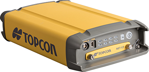
Topcon Announces Geodetic Reference Receiver and Antenna

Topcon’s NET-G5 receiver and CR-G5-C antenna. Photo: Topcon Topcon Positioning Group announces the next generation of its geodetic GNSS reference receivers and antennas — the NET-G5 receiver and CR-G5-C antenna.
The announcement was made at InterGeo 2014, being held this week in Berlin.
Using Vanguard and Universal Tracking technologies, the NET-G5 receiver incorporates 452 channels capable of tracking the full GNSS signal spectrum, including modernized GPS, GLONASS, Galileo, Beidou, QZSS and SBAS signals. Universal Tracking has the advantage and capability to assign any visible GNSS signal to any available receiver channel.
The NET-G5 receiver is designed to work as a complete system connectivity solution, with built-in Bluetooth and Wi-Fi, for flexible wireless communications or via standard Ethernet, serial and USB connections. Other features include: High-precision code and carrier phase measurements up to 100 Hz; Power over Ethernet (PoE) and an all new Topcon receiver web interface with advanced receiver management features.
“Comprehensive communication support, advanced web-server capability, and extended operating times are among the new features supported on the NET-G5. Coupled with the CR-G5-C antenna, the new systems provides a powerful, interference protected network solution,” said Charles Rihner, vice president of the Topcon GeoPositioning Group.
“Whether you are installing an all-new GNSS network infrastructure, expanding or upgrading an existing network, looking for a premium campaign receiver or stand-alone RTK base station, the high-performance NET-G5 is designed to provide the most advanced reference station solution available in the market,” Rihner said.
The CR-G5-C is a full-wave geodetic choke-ring antenna designed to address evolving requirements for reference networks and infrastructure monitoring applications. “The CR-G5 antenna has excellent vertical phase center stability over the entire GNSS frequency band, providing superior performance in tracking low elevation satellite signals,” Rihner said. “This new model employs cavity filter technology to more aggressively combat radio frequency interference in difficult environments.”
-
Spectra Precision Launches Central Cloud Service, New Software Versions
Spectra Precision introduced a new cloud computing service for Spectra Precsion applications. The company also announced new road modules for version 5.5 of its Survey Pro software and for Spectra Precision Survey Office.
The announcements were made at InterGeo 2014, being held this week in Berlin.
Spectra Precision Central is a new cloud computing service. Photo: Spectra Precision Spectra Precision Central. A dedicated cloud computing service for Spectra Precision survey applications, Spectra Precision Central offers survey teams in the field and office the ability to rapidly exchange survey and project data with team members when and where it is needed.
“Spectra Precision Central is a straightforward and uncomplicated solution that offers significantly improved data management efficiency for virtually any size land survey firm,” said Olivier Casabianca, Spectra Precision business area director. “Field crews can store project data to a Central account in the cloud using a data collector with Survey Pro, a connected computer or most smartphones and have the data immediately available to other work groups in the field or office. All data is synchronized for either online or offline use by any connected office computer and data collector.”
As part of the Spectra Precision Central service, users can download Survey Pro Central, a free smartphone app, which enables iOS and Android devices to connect directly to the Spectra Precision Central system. Survey Pro Central provides another easy way to access documents, upload and download files, and manage survey data. Survey Pro Central also supports a coordinate viewer, a raw data viewer, and a map display that can also use Google maps. Whatever sensor is being used, a total station or GNSS receiver, the Spectra Precision Central system provides the hub to permit crews to transfer and share data through their Central cloud account.
A one-year Spectra Precision Central license is included with the purchase of any model Spectra Precision data collector with Survey Pro. Each Central account can have as many users and logins as the business requires. Maintaining the Survey Pro extended warranty annually automatically renews the license. Data in the account is always available, even if the subscription expires, by simply synchronizing the data in the Central cloud to the office computer.
Survey Pro Version 5.5. Spectra Precision Survey Pro version 5.5 now includes a new road module and integration with Spectra Precision Central. Survey Pro version 5.5 is the latest release in 20 years of continuous development.
Survey Pro version 5.5 is fully integrated with the new Spectra Precision Central cloud system. Files can be automatically or manually synchronized to the cloud which then synchronizes data back to the office or smart phones. This new feature provides access to a user’s data whenever they need it and provides an off-site backup service for valuable data.
The new road module is used for importing, managing, and staking roads. The module directly supports the data from the new version of Spectra Precision Survey Office. Now roads can be designed in Survey Office, exported to Survey Pro on the data collector, and staked in the field providing a complete system. The new system includes a number of improved and enhanced features as well as new graphic and data views.
Other features include a new GNSS interface to improve workflows, a new multi-point backsight setup routine, and many other enhancements.
The new version will be available for all customers who are current with a maintenance plan. Customers who are not current can purchase a new maintenance plan to get the latest updates including a Spectra Precision Central account.
Spectra Precision Survey Office. Spectra Precision Survey Office (SPSO) now includes support for advanced roading that allows for allows for the creation, import, export and edit of corridors and roads.
The new roading module allows users to create cross-sections, create points at intervals, add in material layers and the ability to create and edit templates. This allows for the integration of Survey Pro field software and SPSO office software for a complete solution.
In addition to roading, the SPSO software now includes traverse adjustment, importing of Esri Shapefiles, additional geoid modules, smooth curve feature code and import and export functionality for FAST survey job files.
-
New Trimble Products Focus on Geospatial Imagery
Trimble introduced several new products at InterGeo 2014, being held this week in Berlin, with a focus on incorporating data from photographs and imagery into geospatial databases.
Trimble also offered an expanded GNSS portfolio for surveyors that includes the Trimble NetR9 Geospatial receiver; the Trimble Geo7X with Trimble Access field software onboard; and enhanced Trimble xFill functionality that provides continuous RTK level accuracy when paired with a Trimble CenterPoint RTX subscription. The new additions offer surveyors more flexibility in the field to meet a variety of work requirements. Learn more here.

Photo: Trimble Inpho version 6.0. Trimble announced a new version of its photogrammetric software suite, which provides highly automated workflows for photogrammetry and remote sensing professionals so they can process thousands of airborne images with high precision. Inpho version 6.0 increases efficiency by reducing project turnaround times and improves the quality of deliverables via new automated and interactive tools and satellite triangulation functionality.
A new satellite triangulation function in Inpho version 6.0 allows professionals to quickly generate deliverables from satellite imagery data and expand their capabilities, addressing the needs of industries such as environmental, forestry, agriculture and land management. Automatic tie point extraction and bundle block adjustment provides improved orientation of satellite images. The highly automated process results in a significant reduction in office processing time so projects can be delivered with quality precision in a shorter turnaround time.

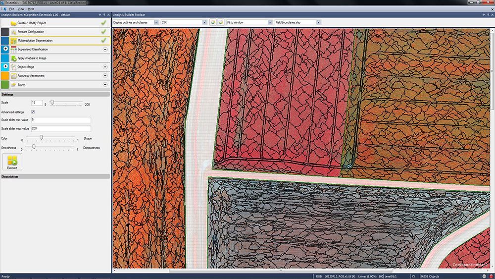
Photo: Trimble eCognition Essentials. eCognition Essentials is a new software solution for geospatial and remote sensing professionals performing land-cover mapping tasks using satellite imagery. eCognition Essentials offers an intuitive image analysis solution that allows users of all levels to quickly produce high-quality, Geographic Information System (GIS)-ready deliverables.
Leveraging core eCognition software technology, eCognition Essentials is easy to use with its simplified and intuitive interface. eCognition Essentials reduces analysis error as it applies predefined and structured rules to analyze and transform imagery data into relevant geospatial information. The new automated image analysis functions — such as image segmentation or sample-based classification — combined with a set of interactive tools for quality control offer users a streamlined workflow for quicker project turnaround times.
Trident version 7.0 is a new version of the mobile data analysis software designed to efficiently manage, interpret and extract features from digital images and point cloud data collected via land mobile systems. Enhancements in the new version significantly reduce the time required for geospatial professionals to transform land mobile sensor data into relevant geospatial information used in civil engineering, transportation and GIS mapping. In these applications, Trimble Trident can be used for surface modeling, roadway sign and pole detection, lane marking detection, edge and breakline detection, road geometry and clearance measurements.
Trident version 7.0 offers increased automation functionality to deliver results more quickly. Updated feature extraction tools within the software provide greater reliability and minimize manual editing and verification. Trident version 7.0 breakline detection routines now include a cross-sectional workflow for rapid and progressive development of supervised roadway breakline models.

Photo: Trimble Trimble V10 Imaging Rover. The Trimble V10 is an integrated camera system that precisely captures 360-degree digital panoramic images for visual documentation and measurement of the surrounding environment. Enhancements include additional integration options and high-dynamic range (HDR) imagery. The Trimble V10 offers an accessible and efficient means of visually documenting site conditions to perform measurements in the office, produce more powerful deliverables and speed up decision making for managers on or off the site.
In addition to the R10 GNSS receiver, the Trimble V10 Imaging Rover now seamlessly integrates with Trimble’s R-Series GNSS receivers — the Trimble R8, R6 and R4 — and TSC3 controller. Through this seamless integration, geospatial professionals can easily capture high-quality, geo-referenced panoramic images to document the surroundings. Now more Trimble customers can take advantage of the Trimble V10’s powerful capabilities. In addition, a new two-piece power rod option enables easy transportation of the Trimble V10.
-

Danger, Will Robinson! Beware the IMES of Japan

The IMES navigation concept. Credit: IMES In May 2011, Dinesh Manandhar and Hideyuki Torimoto of GNSS Technologies, Inc., Japan, penned a very interesting article in GPS World titled – Opening Up Indoors: Japan’s Indoor Messaging System, IMES. The opening paragraph of their lengthy article seemingly describes the Holy Grail for the indoor positioning lobby:
“An indoor messaging system (IMES) has been developed to meet the challenges of indoor and deep indoor positioning, as a system that can be implemented in any device that has a GPS/GNSS receiver without hardware modification. IMES can provide reliable 3D position data with a single transmitter device without performing range calculation[s].”
They go on to describe the IMES concept thusly:
“The main concept of IMES is to transmit position and floor ID of the transmitter with the same RF signal as GPS. IMES transmits latitude, longitude, height, and floor ID by replacing the ephemeris and clock data in the navigation message of GPS. A single unit of IMES is enough to get the position data, since the position itself is directly transmitted.”
Now, you don’t have to be a rocket scientist to start thinking about interference and spoofing issues or risks, especially when you read that the navigation message ephemeris and clock data are being replaced by data broadcast by IMES. To be fair, the authors address these issues briefly:
“Since IMES shares the same frequency as [the] GPS L1 band (1575.42 MHz), there is an interference level that IMES may have on GPS signals. This interference has been studied in detail by conducting experiments and simulations. Based on these studies and analysis, various methods have been considered to avoid harmful interference to GPS signal. To avoid such interference, IMES center frequency is shifted by +/– 8.2 KHz from GPS L1 band. This will have the least impact on the GPS L1 band signal. For example, if the IMES signal is –110 dBm (very strong) and the GPS signal is –142 dBm (very weak), the loss of GPS signal (C/N0) due to IMES is less than 2 db. If the IMES signal is –120 dBm and the GPS signal is –142 dBm, there is no loss of GPS signal (C/N0). Based on this analysis, the IMES transmitter power must be controlled such that the maximum power to the receiver does not exceed –110 dBm at a distance of 3 meters from the transmitter. [There are] guideline[s] specified in the QZSS IS document for setting the transmitter effective isotropic radiated power (EIRP) based on location.”
Let’s put these concerns in perspective. I thoroughly enjoyed the article and firmly believe that we desperately need to solve the indoor positioning and navigation problems, especially for our warfighters and first responders. While many of today’s excellent commercial receivers work well indoors near windows and doors, they are absolutely abysmal underground and deep inside large buildings with lots of metal, or in the middle of dense urban canyons such as Tokyo, Japan. Without a doubt, there is a dire need for a system like IMES — or maybe exactly like IMES — but there must be some caveats and stipulations as to how the IMES system is implemented.
Not Alone
Fortunately, I am far from being a lone wolf in voicing my concerns and my position, for once again the conspiracy theorists as well as renowned scientist and policy makers are concerned about IMES and the operating systems they supposedly desire to replace or augment. Chief among them is the Father of GPS, Dr. Bradford Parkinson, who has frequently described improperly operated in-band pseudolites as “…just another name for a legal jammer or spoofer.” Having known Brad for almost 40 years, I am convinced few GPS experts in the world today have as much experience with pseudolites as Dr. Parkinson. Consequently, the very reason that an indoor navigation system such as IMES is needed may well be a portent for why it may well fail, unless it is implemented properly.
It would be easy but extremely tedious to write about the numerous issues facing IMES in a complicated and technical manner. Certainly previous articles have become bogged down in minutia, and I want to avoid that. It is actually very simple. The issues are fairly straightforward and should be faced head on and not hidden in the midst of tech-speak lingo, legal jargon, policy minutia or politics. So lets dive straight in, shall w,e and make sure these issues see the light of day?
Interference
There can be no doubt that IMES has the potential to significantly interfere with GPS and QZSS signals. The authors of the IMES article are quite clear concerning the potential for interference, and in their own way attempt to mitigate it with signal power restrictions. Their example of a small three- to four-story building with IMES transmitters may indeed be adequate for signal power mitigations, but what happens in Tokyo where tall buildings — skyscrapers if you will — abound? When the Tokyo Skytree skyscraper opened to the public in 2012, it was then listed as the world’s tallest tower and Japan’s biggest new landmark. At over 2,080 feet tall, this is definitely the type of building where one would need an IMES system. With an average of 20 IMES transmitters per floor and weighing in with over 200 floors, we can quickly see that there would be over 4,000 IMES transmitters in this one building alone, all broadcasting simultaneously on or near the center frequency for GPS. Absent stringent regulations and infinite care (the IMES article authors propose that the pseudolite network operator will have the responsibility to continuously monitor each pseudolite and the pseudolite network to prevent interference), and perhaps even with those caveats in place, the GPS L-band noise floor would be such that GPS signals would be incapable of being received.
Now, put 20 such buildings in a ten-block area and the noise floor would be almost incalculable and certainly not predictable. Dr. Parkinson’s fears are realized; your legalized IMES system becomes a distributed network of jammers and/or spoofers. However, technically IMES is currently far from being a legal jammer or spoofer as currently IMES transmitters are not legal to operate in the GPS band at 1559-1610 MHz under the International Telecommunications Union (ITU) Treaty per the International Table of Frequency Allocations of the ITU Radio Regulations. The ITU further states that IMES currently operates on an interfering basis with the co-primary allocations (ARNS/RNSS) in this band, and therefore are in violation of the ITU Treaty. However, Japan’s frequency regulatory agency can develop and implement regulations that allow IMES operations. When this occurs, if not operated within stringent guidelines, IMES could then be considered a legalized jammer or spoofer.
Even the Joint Research Centre of the European Commission, the JRC, states in its Executive Summary on pseudolites that in-band pseudolites pose a significant jamming risk to GNSS receivers. Specifically they state:
Pseudolites or pseudo-satellites are an emerging technology with the potential of enabling satellite navigation indoors. This technology found several applications that are not limited to indoor navigation. Precise landing, emergency services in difficult environments and precise positioning and machine control are few examples where pseudolite technology can be employed.
Despite the great potential of this technology, severe interference problems with existing GNSS services can arise. The problem can be particularly severe when considering non-participating receivers — legacy devices not designed for pseudolite signals. The design of pseudolite signals is thus a complex problem that has to account for market requirements (modifications of existing receivers for enabling the use of pseudolite signals, measurement accuracy, target application), regulatory aspects (frequency bands to be allocated for pseudolite services) and interference problems.
JRC investigates the main aspects to be considered for the design of a pseudolite signal standard minimizing the interference problem without compromising the location capabilities of the system. The focus is on the signal characteristics and topics relevant for the signal design.
Pseudolite or Communications System
The second technical portion of the interference issue revolves around how exactly you define IMES, for when you are dealing with radio regulation agencies semantics matter. Think back to the first paragraph of this article where the IMES authors defined IMES as a messaging system. That certainly sounds like a communications system to me, and others agree. Consequently, the question has been raised and rightfully so: Is IMES a navigation and positioning system, a pseudolite or a communications system? Honestly, to me it sounds like a bit of all three, but if you define it as a communications system, then Japan is seeking to authorize the integration of a communications system with known significant interference issues with GPS signals right in the middle — indeed, potentially on the center frequency of the protected navigation band using terrestrial PRN codes assigned by the U.S. government. If IMES is deemed an indoor pseudolite, then the interference issues are still there. But it is defined as a bonafide PNT system using authorized terrestrial PRN codes. Talk about a bucket of worms!
The issues here are numerous, and they need to be fully addressed to ensure that all those who are potentially affected clearly understand what is being proposed and the risk for the public at large, including who owns responsibility if something goes wrong. I could go on for several pages on this issue alone, but suffice it to say, we do not want to authorize a communications system that is a known and acknowledged GPS interferer right in the middle of the band — or anywhere in the band for that matter. Remember all the issues GPS had in the past several years with a communications system in adjacent bands. So, do we really want a known communications system — or communications system masquerading as a pseudolite, for that matter — with known GPS signal interference issues in the restricted GPS frequency spectrum? The blaringly obvious answer is absolutely not! Yet this is exactly what the IMES authors are proposing not only for Japan, but eventually, if they receive authorization, for other countries around the globe as well. Japan has twice petitioned the U.S. government to make the assigned IMES terrestrial PRN code allocations global in nature. Fortunately, to date those request have been denied.
Dichotomy
Certainly, other countries and companies have noticed this apparent frequency authorization dichotomy and are following suit. For instance the Conference of European Postal and Telecommunications agencies, or CEPT, which is Europe’s regional representative to the World Radiocommunication Conference (WRC), has proposed adding several troubling IMES-related agenda items for the quadrennial WRCs coming up in 2015 and 2019. Even more importantly, these critical issues could be aired in the next three weeks, as the agenda for the 2015 WRC will be largely set at a plenipotentiary conference happening October 20 through November 8 in Busan, South Korea.
There are what I consider to be dangerous proposals under consideration by the ITU (International Telecommunication Union), which should concern GNSS users worldwide. The ITU is the United Nations’ specialized agency for information and communication technologies — ICTs. This is the ITU, where every member state (currently 193) gets one vote, whether they fully understand the technical issues or not and regardless of whether they are a space-faring nation or have a dog in the fight, so to speak. This means that the vote of tiny Saint Lucia counts the same as the United States or Canada or Australia. The ITU charter is to “…allocate global radio spectrum and satellite orbits, develop the technical standards that ensure networks and technologies seamlessly interconnect, and strive to improve access to ICTs to underserved communities worldwide.” Fortunately, the ITU regulations, unlike the CEPT or IMES proposals, wisely require new transmitters proposing to operate in the radio navigation spectrum to operate without causing interference to primary users. Meanwhile, there are member states, countries and companies that want to capitalize on this seeming dichotomy within the global safety-of-life, historically protected, radio bands. Those nefarious efforts, for the future of GPS and GNSS worldwide, need to be stopped in their tracks.
Spectrum is a limited and valuable resource, to say the least, and here fortunately the ITU regulations have it right and do not risk human life, by intruding and potentially interfering with the frequencies used globally by airliners to control, route and land aircraft. I am convinced there are solutions available to us through cooperative efforts with the ITU and other national organizations that will produce pseudolites without causing interference in the protected safety-of-life frequency bands.
When Is a PRN Code Not a PRN Code?
Some of you who are a bit more savvy or have been following this fiasco for some time may now be thinking, what’s the problem, the IMES authors are merely using and proposing further use of U.S. government-authorized terrestrial PRN codes for IMES. This indeed touches on the third thorny issue, which is not only technical but political as well — the use of and authorization to use PRN codes for what is ostensibly a communications system, if you believe the authors of the IMES article, who go to great lengths to differentiate IMES from pseudolites. They continually make the argument that IMES is not a pseudolite, but as we shall soon see, when the U.S. government authorized these specific PRN codes (173-182) for Japan, they were to be used solely for a low-power terrestrial pseudolite program, not an in-band communications system.
Technically, these specific PRN codes assigned to the Japanese for IMES expire in 2017. The authorization of these PRN codes come with numerous restrictions that legally make the codes useful only for the Japanese landmass. This is where the technical, political and operational issues come to a head. We are in for some tough sledding here. However, I will endeavor to make it as simple as possible.
History
In 2007, ten PRN codes were specifically assigned to the Japan Aerospace Exploration Agency or JAXA “for the Indoor Messaging System (IMES) terrestrial pseudolites of the Quasi-Zenith Satellite System (QZSS).” The Memorandum of Agreement from the GPS Wing at SMC (Space and Missile Systems Center) in Los Angeles at Los Angeles Air Force Base (LAAFB) clearly states that the codes are valid for ten years and expire on 19 November 2017, unless a renewal application is filed and approved. Hence, PRN codes 173-182 for IMES were assigned with several crucial caveats and restrictions by the U.S. government that are definitely pertinent to our discussion:
- The codes are designated for low-power terrestrial regional applications limited to Japan only.
- Although the GPS Wing conducts an initial check on PRN number requests with respect to potential interference issues, the issuance of a PRN number does not convey authority to radiate in the [GPS] band. In order to radiate in the GPS L1 band, the applicant [Japan] shall obtain a frequency assignment from the [Japanese] national authority.
- The GPS Wing assumes no responsibility for ensuring systems using these spreading codes follow domestic radio frequency regulations or other applicable laws or regulations, or for ensuring that systems using GPS PRN codes do not cause radio frequency interference.
- GPS PRN codes were developed for signals transmitted from satellites, and are not necessarily optimized for use by terrestrial transmitters.
- The maximum effective isotropic power for each terrestrial transmitter will be less than -94 dBW.
- The QZSS [organization] is responsible for the redistribution of these spreading codes throughout Japan and will limit their use to Japan only.
With all these restrictions, it is difficult to see how the IMES authors could legally use, distribute or promote authorization of IMES and the use of the PRN codes outside of Japan and at the power levels related in the GPS World IMES article. Regardless of the IMES author’s interpretation of the PRN code assignment, the GPS Wing 2007 Memorandum restrictions and caveats are clear, and it cannot be disputed that the codes expire in 2017 unless renewed by the USAF. The PRN codes are restricted to the landmass of Japan even if they are renewed, and if IMES wishes to broadcast anywhere in the GPS band, they need to have permission from their national frequency allocation authority (the Ministry of Internal Affairs and Communications, which is equivalent to the U.S. FCC –Federal Communications Commission) to do so.
The Way Ahead
This is the easy part from my perspective. See if you don’t agree. If the U.S. government is concerned about IMES and what Japan is planning to do with the assigned PRN codes for terrestrial use, the U.S. government through the USAF has the options to:
- Rescind the PRN codes immediately.
- Insure the Japanese adhere to the caveats and restrictions in the original Memorandum.
- Simply refuse to renew or recertify the codes for future use and/or recommend for IMES frequencies that are outside the protected GPS band.
- Update and clarify the footnote on the GPS Wing PRN Codes website pertaining to the Japanese IMES PRN Codes with all the restrictions listed in the GPS Wing Memorandum so other countries will realize this is not a global IMES PRN assignment.
Japan is a valuable ally and we need to work together cooperatively, but frankly, the plans laid out for IMES by the authors in the GPS World article must be troubling to those whose job it is protect the GPS spectrum and enforce mutual agreements with our allies. If we were just concerned about a Japanese IMES system, this whole discussion might be moot. However, other countries and commercial companies around the world are watching closely and laying the groundwork for similar IMES and pseudolite incursions into the GPS L-band spectrum — if the Japanese are allowed to proceed and the limited use of PRN codes for IMES is not clarified for all. No one, and I include the Japanese, wants to see this happen if it means interference with GPS, and QZSS for that matter.
Fortunately, where European countries are concerned, there are the ITU regulations. Specifically for GPS and pseudolites, the CEPT regulation has a license condition that requires the pseudolite network operator to submit to the European country regulator confirmation of the terrestrial PRN codes from the GNSS operator before operating pseudolites in the GPS band. So again, the U.S. government wields the hammer here.
Therefore, the U.S. government must act immediately and decisively to put an end to the threats against the protected GPS spectrum caused by the proposed in-band IMES system. At the same time, the Japanese government has an obligation and responsibility to adhere to the letter of the law where the original GPS Wing 2007 IMES Memorandum is concerned.
Finally, the U.S. government must urgently engage cooperatively with the European Union administration and Japan to prevent the authorization and proliferation of interfering devices in the GNSS frequency bands, and to work together to ensure the positive benefits to GNSS from commercializing pseudolite uses outside the GNSS radio frequency bands. GNSS manufacturers worldwide are successfully marketing commercial pseudolites that do not cause interference. In my opinion, this is the way to go both in terms of regulations and governance.
Until next time, happy navigating, and remember GPS is brought to you free of charge by the United States Air Force.
-
Trimble Offers Pipeline Construction Software for Oil and Gas

The Trimble Access Pipelines launcher. Trimble announced today an addition to its Trimble Access family of field software applications: Trimble Access Pipelines. Designed for surveyors involved in oil and gas pipeline installation, Trimble Access Pipelines addresses challenges encountered by pipeline surveyors by automating common pipeline survey tasks. The software solution saves time by simplifying attribute and inventory collection and integrating all the data into one easy-to-use data collection workflow.
The announcement was made today at InterGeo 2014, the world’s largest conference on geodesy, geoinformatics and land management.
Trimble Access Pipelines, a new addition to the ever-increasing suite of applications available for Trimble Access field software, offers a streamlined workflow for pipe inventory collection and validation, weld mapping and as-built measurements. The software significantly reduces project time and redundancies by collecting pipe attribute data, recording the relationship between welds and pipes, and electronically linking the joint attributes to measured welds. Using the application, pipeline surveyors can capture the necessary data so construction can proceed without costly delays.

The complete end-to-end solution is enabled when combining the power of Trimble Access Pipelines and Trimble Business Center. Trimble Access Pipelines can quickly generate customized reports for the tally and weld map data or the surveyed pipeline directly on the controller. All field data can be seamlessly transferred into Trimble Business Center to produce rich, complete deliverables including as-built plots using the Trimble Business Center Advanced Drafting module.
“One of the most time consuming challenges pipeline surveyors face is the collection of pipe attribution detail and recording the information with weld positions,” said Benoit Mallen, business area manager of Oil and Gas for Trimble’s Geospatial Division.”With Trimble Access Pipelines, we have leveraged Trimble’s strength in positioning technology and combined it with a workflow-specific application to create a streamlined solution that can meet the needs of geospatial professionals working in the oil and gas industry.”
Trimble Access Pipelines and Trimble Business Center Software version 3.30 are available now through Trimble’s Geospatial Distribution Channel.
A free trial of the Trimble Access Pipelines application as well as other available modules for Trimble Access are available to all existing Trimble Access users, and can be activated and installed using the Trimble Access Installation Manager. For more information on Trimble Field software, visit www.trimble.com/Survey/Field-Software.
-
Trimble Offers Expanded GNSS Portfolio for Surveyors
Trimble has introduced additions to its GNSS portfolio — the Trimble NetR9 Geospatial receiver; the Trimble Geo7X with Trimble Access field software onboard; and enhanced Trimble xFill functionality that provides continuous RTK level accuracy when paired with a Trimble CenterPoint RTX subscription. The new additions offer surveyors more flexibility in the field to meet a variety of work requirements.
The announcement was made today at InterGeo 2014, the world’s largest conference on geodesy, geoinformatics and land management.

The Trimble NetR9 Geospatial GNSS Receiver. Photo: Trimble Trimble NetR9 Geospatial GNSS Receiver. The Trimble NetR9 Geospatial has been configured as a comprehensive modular GNSS receiver for the professional survey market. The lightweight form factor of the NetR9 comes fully loaded with performance enhancements including: Trimble HD-GNSS technology, Trimble 360 technology, Trimble CenterPoint RTX correction service support and Trimble xFill technology. The combination of these capabilities provide a powerful solution that delivers accurate positioning and support for all existing and currently planned GNSS constellations, and continuous RTK-level precision during interruptions of the primary correction source, Trimble said.
Serving as either a rover or mobile base station, the NetR9 Geospatial offers the flexibility to choose a GNSS antenna and radio solution that matches the surveyor’s specific workflow needs. “Trimble’s GNSS solutions are designed to meet the unique requirements of surveyors,” said Elmar Lenz, business area director of GNSS Solutions for Trimble’s Geospatial GNSS Division. “These solutions provide professionals in the survey and engineering industry with flexible tools to stay productive and competitive, delivering the appropriate solution for any survey project that’s being completed, no matter where our customers work and survey.”
Trimble Geo 7X with Trimble Access. Designed for surveyors facing a variety of workflow requirements to accomplish both high-accuracy surveying and handheld point measurement, the Geo7X is now available with Trimble Access field software onboard. With Trimble Access onboard the Geo7X, surveyors benefit from a familiar, easy-to-use software interface that provides common survey workflows directly on their GNSS handheld, resulting in increased data collection efficiency.
The Geo7X is a dedicated network rover that can be used on a survey rod with an external antenna for survey-grade accuracy. If the surveyor prefers the convenience of a highly mobile handheld solution, they can snap if off the rod and switch to the internal antenna. In this mode, they also have easier access to other features such as the integrated camera for collecting attribute data.
Trimble xFill in use. Photo: Trimble Expanded Trimble xFill Functionality. Expanded xFill functionality, available in the Trimble R10 GNSS receiver and NetR9 Geospatial receiver, allows surveyors to continue collecting data with centimeter accuracy indefinitely throughout their workday when the connection to the base station or VRS network is lost. The expanded xFill functionality is enabled via a CenterPoint RTX subscription.
Without a Trimble CenterPoint RTX subscription, xFill maintains RTK level accuracy for up to five minutes during interruptions in the primary terrestrial correction stream. This basic xFill functionality is included with the Timble R10 GNSS system and is now included with the NetR9 Geospatial GNSS receiver.
“With expanded accuracy levels and seamless RTK/RTX transition, the Trimble R10 continues to offer unprecedented capability to the survey professional,” said Lenz. “Connectivity problems are traditionally one of the biggest GNSS-related challenges a surveyor will face while in the field and expanded Trimble xFill functionality significantly helps solve that problem, saving time and money.”
-
Carlson Software Introduces Surveyor2 Data Collector at InterGeo

Photo: Carlson Software The Carlson Surveyor2, the newest model of Carlson Software’s Carlson Surveyor line of data collectors, was launched at the InterGeo Trade Show in Berlin this week.
The handheld surveyor is on display at Carlson’s Stand 1.037, Hall 1.1, at InterGeo.
Fast, durable and more powerful, the Carlson Surveyor2 is ruggedized, with an IP68 water and dust-resistant ingress rating. Still weighing two pounds, the Carlson Surveyor2 offers increased program memory (now 512MB) and increased non-volatile data storage (now 8 gigabytes), and a 1.0-GHz processor to provide the speed surveyors need in the field. It comes equipped with significantly increased Bluetooth range, up to 1500 feet when paired with a class I device.
The Surveyor2’s QWERTY keyboard eases data entry and is designed to be workable even for those with large hands or wearing gloves. The backlit keys and larger, brighter display screen allow users to work effectively in all lighting conditions.
“Not only did the Surveyor2 retain the durability of its predecessor, but its higher-resolution, easier-to-read display screen also comes with scratch-resistant glass,” said Bruce Carlson, president and founder of Carlson Software. “An added convenience is its enhanced battery life — up to 20 hours.”
The Surveyor2 has kept its easy-to-grip design, being thinner front to back than other data collectors when resting on a table top. The computer runs on Windows Mobile 6.5.3 and Carlson SurvCE 4.0 can be included. SurvCE is the powerful data collection software used around the world.
The Surveyor2 is designed for surveying, stake out, construction layout and GIS mapping. The easy-to-use, tab-based menu and advanced graphics in Carlson SurvCE 4.0 enhance the Carlson Surveyor2’s usability. Options include an integrated GSM cell modem for real-time connectivity, an integrated 5 MP camera with LED illuminator that doubles as flashlight, and a mapping-grade GNSS receiver.
-

Hemisphere GNSS Offers New Survey-Grade GNSS Antennas

The A25 and A45 antennas. Photo: Hemisphere GNSS Hemisphere GNSS has announced two low profile, multipurpose antennas that it says will exceed expectations in all GNSS applications. With unique filtering patterns and precise attention paid to mitigation of multipath and interference, the A25 and A45 antennas complement all GNSS products, from L1 GPS to multi-frequency, multi-constellation.
Both antennas are being featured at the InterGeo 2014 Conference and Trade Show in Berlin this week, at stand C2.007.
The A25 and A45 have been designed to support millimeter accuracy for land and marine applications. Both antennas support present and future GNSS signals, including GPS, GLONASS, BeiDou, QZSS, and Galileo. The A25 supports the previously mentioned signals at a single-frequency level, while the A45 supports these signals at a multi-frequency level.
“We’ve designed these antennas to excel in challenging environments such as near buildings or under foliage,” said Lyle Geck, senior manager of product marketing at Hemisphere GNSS. “They have superior multipath mitigation, stable phase centers and strong SNR’s, even at low elevations.”
The ruggedized housing used by both antennas is made of an aluminum base that has been pretreated for the marine environment and will withstand salt, fog, and spray. The antennas pass the two-meter pole drop test.
The A25 is a multi-GNSS precision antenna, designed for a variety of applications including GIS, single-frequency RTK positioning and navigation, and precision guidance. The A45 is a survey-grade, multi-GNSS precision antenna for a variety of applications including surveying, RTK positioning and navigation, precision guidance, and machine control.
For more information about Hemisphere GNSS’ antennas and other products, please visit www.hgnss.com/Products-Solutions.
-
Applanix Offers Single-Board GNSS-Inertial System for UAV Mapping
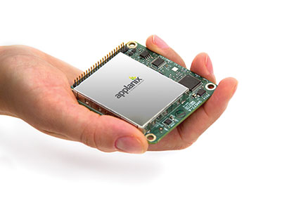
Photo: Applanix Applanix, a mobile mapping and positioning company, has introduced a new product that enables major improvements in unmanned airborne mapping: the Applanix APX-15 UAV GNSS-Inertial System. The announcement was made at InterGeo, being held this week in Berlin.
The APX-15 UAV is designed to maximize the efficiency of mapping from small unmanned aerial vehicles (UAVs) by reducing — or even eliminating — Ground Control Points (GCPs). Sidelap is also significantly reduced, increasing the area flown per mission. The Applanix APX-15 UAV provides performance in a small package and, with the included POSPac UAV post-mission software, produces a highly accurate position and orientation solution for direct georeferencing of cameras, LIDARs and other UAS sensors, the company said.
“Applanix has recognized the need to provide the growing UAS mapping market with the same highly efficient solutions that it pioneered for airborne mapping over 15 years ago,” said Joe Hutton, Director of Inertial Technology and Airborne Products at Applanix Corporation. “We are offering a cost-effective solution that meets the size, weight, power and cost requirements of small UAS, and maintains the Applanix pedigree for quality and performance.”
The APX-15 UAV, measuring just 6 cm x 6.7 cm and weighing only 60 grams, features a high-performance, survey-grade, multi-frequency GNSS receiver and low-noise MEMS inertial sensors all on a single board. The Applanix IN-Fusion GNSS-Inertial integration technology runs directly on the GNSS receiver, resulting in an ultra-compact design, while superior performance is achieved from the inertial sensors using the Applanix SmartCal software compensation technology.
With 220 channels, the APX-15 UAV tracks all available GNSS satellite signals including GPS L1/L2/L2C/L5 and GLONASS L1/L2, QZSS, BeiDou and Galileo, and provides a highly accurate post-mission and real-time RTK GNSS-inertial position and orientation solution to support guidance and control, precision landing and sensor geo-referencing.
APX-15 UAV is expected to be available worldwide in the first quarter of 2015 through the Applanix sales channel.
-
NGA Issues Advisory Notice on Web Mercator for Mission-Critical Operations
The National Geospatial-Intelligence Agency (NGA) has issued an advisory notice on the use of Web Mercator for mission-critical operations.
The notice outlines application risks to operations and adherence to Department of Defense World Geodetic System 1984 (WGS 84).
“This message outlines the risks associated with the use of Web Mercator applications for DoD and GEOINT user community operations. The NGA Geomatics Office has assessed the use of Web Mercator and other non-WGS 84 spatial reference systems may cause geo-location / geo-coordinate errors up to 40,000 meters. This erroneous geospatial positioning information poses an unacceptable risk to global safety of navigation activities, and Department of Defense, intelligence community, and allied partner systems, missions, and operations that require accurate and precise positioning and navigation information. The NGA Geomatics Office reminds the community to use DoD approved World Geodetic System 1984 (WGS 84) applications for all mission critical activities.”
Many popular commercial visualization, mapping and mobile web device applications use a Web Mercator spherical earth reference. “These applications are not an equal alternative to DoD WGS 84, as they do not provide the same geo-coordinates or geo-location accuracies,” the advisory states.