Trimble has introduced the latest version of its smart water infrastructure mapping and work management software — Trimble Connect version 1.8. The latest release of the cloud-based, geographic information system (GIS)-centric software includes a suite of applications that allow water, wastewater and stormwater utilities to visualize and efficiently manage their network maintenance and data collection activities.
Trimble Connect software leverages Trimble’s GNSS rugged mobile devices and Esri’s GIS technologies to accurately map, locate and assess the condition of critical infrastructure assets, allowing utilities to keep their field infrastructure data up-to-date and accurate. Offered as a software-as-a-service (SaaS) subscription, the solution allows users to monitor asset operating conditions, manage leak repairs, reduce non-revenue water, deploy and inspect smart meters, lower potential threats to safety and health due to contamination and adhere to regulators’ reporting guidelines and requirements. Trimble Connect version 1.8 can be configured and deployed quickly on a variety of Trimble and non-Trimble mobile devices, laptops, tablets and smartphones, including Apple iPads, iPhones, Android, Windows and Windows Mobile devices to automate field workflows and eliminate paper-based maps.
Trimble Connect utilizes the latest Esri ArcGIS 10.2.2 for Server, Mobile and ArcGIS Online basemap services. The software is designed to automate a variety of specific water and wastewater industry workflows through individual “apps” offered within the product and as part of a subscription. The new version provides standard core apps including Map Book, Manhole Inspector, Leak Repair, Hydrant Inspector, Valve Inspector, Meter Changeout, Incident Repair, Water Mapper, Wastewater Mapper and Stormwater Mapper. In addition, an optional partner app developed for American Flow Control (AFC) hydrant and valve data collection, “AFC Mapper,” can be purchased from AFC and their distributors for use with Trimble rugged handhelds.
In addition to the standard core apps, Trimble Connect version 1.8 includes:
Full offline mobile support including GIS data for Android, iOS, Windows Mobile and Windows 7/8 platforms
Esri ArcGIS Online (AGOL) support to create and share Web Maps using data collected in Trimble Connect
Work management support for single and multi-asset work orders on all supported platforms
Enhanced workflows for asset inspection and condition assessment
Embedded business rules to define failed inspections or ones that need review
Enhanced workflows for asset mapping and data collection
Support for the Trimble Geo 7 series rugged mapping handheld and integrated Laser Rangefinder
Trimble has announced three new asset inspection software solutions for heavy civil contractors—Trimble Inspector, Trimble Inspector Pro and Trimble Asset Manager.
Trimble Inspector is a free mobile app that allows equipment managers to easily inspect assets in real-time using their smartphone or tablet.
Trimble Inspector Pro, the premium, subscription version of Trimble Inspector, is used to wirelessly aggregate and share asset condition across multiple sites using Trimble Asset Manager office software.
Trimble Asset Manager software gives contractors the ability to store the inspection data of all assets in a centralized, Web-based database for accurate reporting and documentation.
“Contractors can achieve significant cost savings by proactively scheduling asset maintenance with Trimble’s new inspection solutions,” said Alan Sharp, business area director for Trimble Heavy Civil Construction. “Trimble takes the guesswork out of asset maintenance and puts the control back in the hands of the equipment manager.”
Trimble Inspector, a free mobile app, runs on both Android and iOS smartphones or tablets for daily, weekly and monthly visual inspections using a library of equipment, machine and vehicle types, makes and models, and inspection checklists. Reports containing current visual health status, hours, odometer reading and general condition can be promptly emailed to equipment and maintenance managers. The reports, along with photos, can then be retained for legal documentation of health and safety standards compliance, and for audit purposes. In addition, Trimble Inspector assists with scheduling maintenance to reduce equipment downtime and unplanned stoppages. The app is also ideal for trade-in or auction house inspections of used equipment.
Trimble Inspector Pro has all the functionality of Trimble Inspector, with the added benefits of customized inspection reports to meet health and safety requirements, and comprehensive maintenance reports for service crews. Equipment managers can record equipment service issues and notify site management staff of equipment status on multiple sites within seconds of the completed inspections. Trimble Inspector Pro requires a subscription to Trimble Asset Manager office software to access the additional functionality.
Trimble Asset Manager is a software as a service (SaaS) application used in the office to integrate, store and report asset condition data collected in the field by Trimble Inspector Pro. Asset information is kept in a secure, centralized online database accessible by authorized users in the company. Users can create asset records, document inspections and customize reports so managers get the data they need quickly and easily.
Trimble Inspector and Trimble Inspector Pro are available now worldwide from the Google Play Store or the Apple App Store. Trimble Asset Manager is available now globally through Trimble’s SITECH Technology Dealer Channel.
“Aeroptic is a commercially available mapping system that supports every mission in which the National Guard engages, ranging from incident assessment and disaster response in Domestic Operations (DOMOPS) to reconnaissance and situational awareness on the OCONUS battlefield,” said Kevin Gunde, executive vice president, Surveillance and Exploration Systems. “Aeroptic can be deployed on a variety of fixed- and rotor-wing platforms, including the National Guard UH-60 Blackhawk.”
KEYW developed the Aeroptic solution with image quality, positional accuracy and ease of use in mind. The system integrates a full-color electro-optical (EO) camera, GPS/IMU, and user-friendly geo-processing software based on non-proprietary open standards. The system is compact, light-weight and ruggedized for deployment in harsh environments.
The rapid-refresh EO camera captures imagery of extraordinary quality by employing advanced noise reduction, image sharpening algorithms and high-end lenses with innovative configurations, the company said. The interchangeable lenses offer multiple focal length options that enable the Aeroptic camera to acquire high-resolution visible-band imagery with sub-meter geo-positional accuracy from varying flight altitudes without surveyed ground control points.
Aeroptic offers the option of processing imagery in the air or on the ground, producing unclassified, wide-area ortho-mosaic maps in near real time. Generated imagery products are ready for immediate ingest into standard commercial viewing tools and GIS packages.
“No expertise in GIS or cartography is needed to make full use of the Aeroptic system,” said Kevin Gunde, executive vice president, Surveillance and Exploration Systems. “With just eight hours of training, the typical user can produce content-rich image maps ready for distribution within minutes after acquisition.”
KEYW will be discussing the Aeroptic Mapping System and its many mission applications in booth #512 at the NGAUS General Conference & Exhibition being held August 22-25, 2014, in Chicago’s McCormick Place.
The European GNSS Agency (GSA) has launched a call for proposals to foster further EGNOS adoption in the European civil aviation sector. The grant aims to support projects that enable users to equip and use their aircraft or rotorcraft fleet with GPS/SBAS-enabled avionics and allow Air Navigation Service Providers and aerodromes/heliports to implement EGNOS-based operations in Europe.
The purpose of the call is to co-fund projects capable of fostering EGNOS operational implementation for regional, business and general aviation and rotorcraft. In addition, commercial operators and original equipment manufacturers (OEMs) interested in benefiting from EGNOS may also apply.
Specifically, the call aims to:
Foster the design, development and operational implementation of EGNOS-based operations, including approach procedures at different European aerodromes and EGNOS based routes.
Develop and install GPS/EGNOS enabled avionics and granting of airworthiness certification for RNP APCH procedures down to LPV minima, including the development of Supplemental Type Certificates (STC) or Service Bulletins (SB).
Approve Air Operator Certificates for LPV operations of aircraft already equipped with SBAS capabilities.
Develop enablers to accelerate EGNOS adoption and preparation for its future capabilities, such as LPV 200.
The deadline for submitting applications is 16:00 CET, October 31.
Applications will be assessed in terms of relevance of the proposal and credibility of the proposed approach, economic and societal impact, and coherence and effectiveness of the work plan.
The total budget of the call is EUR 6,000,000 and maximum EU financing of eligible direct costs is 60 percent. In addition, a flat-rate amount of 7% of the total eligible direct costs of the action is eligible under indirect costs.
Awarding of the grants will happen in December 2014, with each grant agreement having an estimated duration of two years.
Omnitracs, LLC, a provider of fleet management solutions to transportation and logistics companies, is making available Omnitracs Tracking powered by Roadnet, a mobile workforce tracking application for smart devices. Omnitracs Tracking offers basic capabilities to help companies track the locations of their mobile workers throughout the day and get additional performance data to help make them safer and more productive, the company said.
“Every transportation company with a mobile workforce wants to know the location and key behaviors of their drivers,” said Dan Speicher, chief technology officer at Omnitracs. “Omnitracs Tracking powered by Roadnet enables companies that have not adopted a fully featured mobile fleet management solution to utilize their existing smart devices in order to track locations of mobile workers, improving safety, productivity and customer satisfaction.”
Benefits of Omnitracs Tracking include:
Location Tracking. By leveraging existing smart device GPS positioning technology, location tracking pinpoints drivers’ locations in real-time using satellite and street maps. Fleet managers access this information through a web-based application, enabling them to provide customers with timely updates on the status of their delivery or service call.
Speed Tracking. The application monitors drivers’ speed throughout the day, allowing fleet managers to take prompt action to help preempt potential safety issues.
Exception Reporting. Users can predefine thresholds for maximum speed allowed, GPS gap, over road speed and stationary position time limits. Exception reporting helps to quickly identify driver behaviors that may lead to unsafe driving and reduced productivity.
“Omnitracs is committed to leveraging the expertise and capabilities of our business units to continuously bring value to our customers. Our newest basic tracking application will give companies the tools they need to better manage their mobile workforce and take fast, appropriate action to improve safety and productivity,” added Speicher.
Omnitracs Tracking is available exclusively through Roadnet and Omnitracs’ resellers. For more information about the application, visit.
The new Renishaw Quarryman Pro 3D laser scanner system uses innovative technology to help optimize blasting and increase the profitability of quarrying operations, according to Renishaw. The system, which also helps to improve safety, was launched at the Hillhead 2014 Tradeshow, held June 24-26 in Buxton, UK.
Quarryman has offered on-site systems for quarries for more than 20 years, improving safety and allowing quarry managers to modify processes simply and swiftly, the company said. The new Renishaw Quarryman Pro is optimized for speed of operation in tough environments, with swift set-up, programming, scanning and data processing, and offers significant benefits over previous models.
New viewing and editing software is quicker to operate, easier to integrate with other mapping software, and includes filtering and data processing functionalities. The sun-readable screen is larger than on previous models, for better visibility, and is now in full color. Data is saved to a USB, rather than a flashcard, for ease of data transfer and larger file capacity.
A GPS mount is built into the handle for quick positioning and easy mapping of point-cloud data to other quarry maps using coordinates, and auto date and time stamping help operators find files, without needing to enter details.
A new Li-ion battery is lighter, provides a greater scan time, and issues a warning when power is low. It also shuts down automatically if not recharged, retaining data for operators to retrieve later. The system’s operating temperature range and processing power have also been increased.
“Customers using the new Quarryman Pro alongside Renishaw’s Boretrak system will see a significant competitive advantage,” said Martin Carr, Business Manager, Mining Systems. “Quite simply, they will access accurate data more quickly, in a wider range of conditions, and be more easily able to export data to other mining software packages. In 20 years of working with quarries, including some of the world’s largest and most competitive global quarrying companies, Quarryman Pro is the best product we have developed, and marks the beginning of a new era for laser scanning systems for the mining and quarrying sectors.”
“The new Quarryman Pro is the first system developed, engineered and manufactured by Renishaw, and customers now have one of the world’s leading engineering technology companies behind the support and service of every unit sold,” said Will Lee, Director and General Manager of Renishaw’s Spatial Measurement Division.
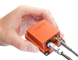
The MTi-G-700 by Xsens is a GPS-aided, IMU-enhanced GPS/INS that offers high-quality orientation and position. It makes use of sensory measurements from magnetometer, barometer, and a high-sensitivity GPS-L1 receiver to provide navigation estimates of position, velocity, and orientation at high data rates under high-dynamic conditions.
The Xsens estimation engine (XEE) sensor-fusion framework enables the motion tracker to take advantage of different aiding sensor measurements and optimally fuse them to get robust tracking estimates. The MTi-G-700 has a u-blox 6 internal 50-channel L1C/A code receiver with 2-meter horizontal accuracy and 5-meter vertical accuracy; SBAS; a 4-Hz update rate; 27-second cold start-up time; and -161 dBM tracking sensitivity.
The MTi is being used by customers for many maritime and oceanographic applications that require 3D orientation, 3D position, 3D velocity, and 3D dynamic data, such as a monitoring system in a barge master vessel where the MTi monitors the movement of a wave-compensated crane.
The U.S. Department of Transportation is holding a “GPS Adjacent Band Compatibility Assessment Workshop” on September 18, 10 a.m.–5 p.m. Eastern Daylight Time. Registration for the workshop is required, and closes September 4. The general public can either attend in person or via WebEx.
The workshop is being held to discuss implementation of a GPS Adjacent Band Compatibility Assessment. Discussion will focus on the various implementation steps of the assessment, including development of GPS receiver use cases, identification of representative GPS receivers, and development of a test and analysis program. “In particular, emphasis will be placed on the information needed from GPS receiver and antenna manufacturers, and the logistics of procuring and handling that information to safeguard manufacturer proprietary data,” according to the Federal Register.
The sponsoring agency is the Office of the Assistant Secretary for Research and Technology, Department of Transportation.
• Name
• Organization
• Telephone number
• Mailing and email addresses
• Attendance method (WebEx or on site)
• Country of citizenship
The meeting will be held at the U.S. Department of Transportation, John A. Volpe National Transportation Systems Center, 55 Broadway, Cambridge, MA 02142. ID is required to enter the building.
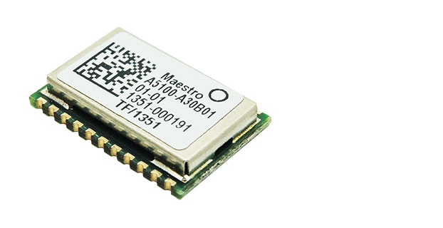
Hong Kong-based Maestro Wireless Solutions, a manufacturer of location receivers, and CSR plc, a global provider of silicon and software solutions for location-aware applications, announce the immediate availability of the A5100-A, a next-generation SiRFstarV GNSS positioning module that combines high-performance GPS and GLONASS receiver technology in a small 10 x 15 mm package.
The A5100-A is designed for a wide range of applications including wearable devices, cameras and automotive trackers.
The A5100-A is the first release within Maestro’s new line of GNSS receivers. It achieves high accuracy with quad-constellation support, up to 30 percent faster time-to-first-fix (TTFF), and up to 20 percent lower power consumption using CSR’s TricklePower and Push-to-Fix (PtF) modes. The module also accelerates customer time to market and reduces development risks by integrating a number of features, including TCXO, SAW filter, RTC, antenna-control mechanism, and flash memory for future-proof upgrades, as well as offering a drop-in replacement capability for Maestro’s previous SiRFstar4 generation modules. The castellated-edge form factor also enables simpler manufacturing and reduces assembly cost, the companies said.
Supporting all currently deployed GNSS, the A5100-A acquires and tracks all visible GPS, GLONASS, QZSS, and SBAS satellites. Concurrent GNSS performance enables the A5100-A to choose the best satellites from different constellations and deliver optimal location information. Immediate benefits are better coverage, enhanced stability, and accuracy in difficult environments, such as urban canyons, and stronger resilience to multipath and signal jamming. This ensures consumers maintain a position fix whether they’re in the middle of a busy city or in a remote rural location, the companies said.
The A5100-A offers a range of other features including:
Direct to Battery connectivity: Connects directly to a rechargeable 1.8V-3.6V Lithium battery enabling system cost reduction and increased power efficiency.
Low Power technology: Optimized for power consumption by incorporating CSR’s PtF technology. PtF rapidly establishes a valid position fix enabling the module to hibernate for longer periods of time, and adaptively changes power depending on the operating environment and motion conditions. Advanced algorithms and a powerful on-chip DSP processor maintain high accuracy (QoS) while achieving the lowest power level possible for the given environmental and motion conditions.
InstantFix Extended Ephemeris (EE): Accelerates TTFF for devices without internet connectivity such as cameras and wearable devices, by autonomously predicting EE for as long as three days and up to 31 days when connected to a network that supports SiRFInstantFix server generated extended ephemeris data (SGEE).
“Maestro Wireless has worked closely with CSR for many years to design and commercialize highly accurate and reliable location products,” said Anthony Murray, senior vice president, Business Group at CSR. “But to win in today’s highly competitive consumer electronics market performance isn’t enough. That’s why we’ve worked with Maestro Wireless to develop a solution that excels in a range of performance metrics but also offers the small form factor essential for today’s compact devices and is highly integrated to help them get to market fast.”
“The A5100-A is perfect for customers designing highly integrated products that need uncompromising performance but are pressured by the speed required to go-to market and lack of development resources,” said Olivier Bernard, EVP of Business Development at Maestro. “By combining low power consumption with high sensitivity, high jamming immunity and concurrent GNSS operation, and with its drop in upgrade path to the A2200-A, the A5100-A creates a fast and convenient route to the latest GNSS offering in the marketplace, to meet these needs quickly.”
Artist’s rendering of GPS III satellite (courtesy of Lockheed Martin).
So, there I was, sipping a cold green tea in the shade on my back deck in the beautiful foothills of the Rocky Mountains in early June, when the phone began to ring off the hook. Upon answering, I was hit with a barrage of questions. Have you seen the GPS III Sources Sought? What should we do? Do you have any advice? Should we respond? But by far the question I thought expressed most everyone’s initial reaction of incredulity was “Are these guys serious?” For frankly this Sources Sought does contain a bit of a giggle factor.
The questions continued and the phone rang all week. Officially the Sources Sought being referenced is the GPS III Space Vehicles Production Readiness Solicitation Number: FA8807-14-R-0008. Prepared or not prepared by, take your pick, the space acquisition folks at SMC (USAF, Space and Missile Systems Center), and it has caused quite a stir in the PNT (position, navigation and timing) industry.
Before we get ahead of ourselves, I should explain exactly what a Sources Sought means in terms of what the U.S. government is looking for and how to respond — in my humble opinion of course.
First a Sources Sought, as defined by the business folks at Georgia Tech (GTPAC) who have researched the matter thoroughly and who I absolutely agree with, is not an actual bid or proposal solicitation; instead, it’s a solicitation of interest. You should think of a Sources Sought as market research being conducted by a government agency or service to determine the capabilities and interests of the marketplace in a specific area, product or capability. This specific Sources Sought should be of interest to companies having an interest and capability to produce products relating to GPS III specifically.
So, that’s the boring official definition, but what is a Sources Sought really? Certainly, the official definition works, but more often than not in my experience, the Sources Sought has also been used to:
Determine what companies, new and established, are players and who is still in the game.
Determine what partnerships might be formed and how companies might work together to provide a required and often difficult capability. Often government acquisition officials will discover a new capability from a trusted supplier, or discover new teaming arrangements that provide a synergy otherwise unavailable.
Determine who is paying attention.
See which companies answer the announcement. Acquisition officials say it is often just as interesting and enlightening to see which companies do not submit a response as it is reading the proposals of the responders, especially if the Sources Sought is being used as justification for a Sole Source award.
Determine if the project has any hope of succeeding, and if so, how do various companies approach the problems involved?
Provide an official and public catalyst for lethargic or too-comfortable contractors that are not getting the job done on a current contract. Fear can be a great motivator.
Enact the old marketing axiom, “Let’s run it up the flag pole and see who salutes.”
Regardless of what you feel the real reason or reasons for the GPS III Sources Sought might be, or even if you have doubts about the seriousness of the release, the one hard and fast rule among marketers is that if you have any capability that even vaguely matches the Sources Sought announcement, then by all means respond.
The official GTPAC advice — and again, I totally agree — is to always respond to a Sources Sought if it appears to be of any interest to you. Just as I have always said to company marketing reps, when asked about the company’s capabilities, the answer, a la Marketing 101, is always “Yes” until it is emphatically “No.” As in:
“Can you build that MDU?”
“Absolutely!” (Stage whisper) “What’s an MDU?”
“Dude, it’s a Mission Data unit.”
“Oh yeah, that MDU. Of course we can build it!”
It may be hard to believe, in this technological day and age, but contracting officials frequently complain about the limited responses they routinely receive to Sources Sought. Responding is usually quick and painless, and can be the first step to place your company in the running for a lucrative government contract. It distinguishes you from your competitors, who did not take the time or effort to respond. The bottom line is it may very well lead to an inside track on an eventual government contract. Just like poker — you can’t win if you are not in the game.
Of course, the reverse is also true, as almost every Sources Sought states. There are no guarantees, and a Sources Sought announcement may — or may not — be followed up by the agency or service with the issuance of an actual bid or RFP (Request for Proposal). The GPS III Sources Sought legalese reads this way: “This notice does not constitute a Request for Proposal. There has been no decision to develop an RFP for the effort in this sources sought notice.”
You take your chances, but nominally it is time well spent, as most Sources Sought require very little in the way of scripted paperwork and government forms. Sometimes the response may be in the form of a simple response on company letterhead laying out your qualifications and stating clearly that you and your company are interested.
However, the government being the government, more often than not the reverse is true, and there may be very specific instructions in a Sources Sought for responding. GTPAC recommends, as do I, that your company follow these instructions to the letter. Give the government no more or less than requested — in other words, give the federal agency or service which posted the Sources Sought notice exactly what it asks for in exactly the form it asks for it.
Now that we are all on the same sheet of music and fully understand exactly what a Sources Sought announcement means, why did this particular GPS III Sources Sought generate so much interest?
Caught off Guard
First I think, well actually I know, this announcement caught almost everyone off guard. It was a surprise, even to those of us who heard rumors about it for some time, not only because of the timing, but also the scope. It far exceeded what most everyone expected —we will get to that shortly. My sources inform me the exact wording and timing were even a surprise to Lockheed Martin Space Systems Company (LMSSC) and Exelis, who are, of course, as incumbents officially excluded from responding.
In retrospect, however, perhaps it should not have been that big of a surprise. General William (Willie) Shelton (USAF), who when this column is first released will have only 48 hours remaining as the commander of Air Force Space Command, had been telegraphing for some time, in sometimes strident language, that he was not happy and something was in the works. He has been uncharacteristically publicly critical of both LMSSC and Exelis for schedule slips and overruns pertaining to GPS III.
Without a doubt, Lt. General Ellen Pawlikowski (USAF), the most recent former commander at SMC (Space and Missile System Center) where the GPS Directorate is located in Los Angeles, California, at LA AFB, let her misgivings concerning a single provider for the GPS III payload be known for some time. Earlier this year, referring to LMSSC, General Pawlikowski was quoted as saying “They know we are not happy — that we are disappointed at the delays we have seen, the technical issues that their subcontractor [Exelis] has had, and probably they are considering whether an alternative source could provide them a better opportunity…I think that Lockheed is doing the right things to figure out how do they best deliver the GPS III in the timelines that they’re expected to.”
In LMSSC’s defense, it was always aware of a possible schedule slip, as was the USAF — for more than two years a bevy of LMSSC engineers and senior managers have been putting in overtime at the Exelis facility in Clifton, New Jersey, to try and wrestle the wayward Mission Data Unit back on track. Many of them are still there, plugging away, including the indefatigable and always optimistic former LMSSC GPS III Program Manager and VP for Space Keoki Jackson.
The MDU is the beating heart of the payload for the GPS III SVs, and it has been in trouble for some time. So, although LMSSC and Exelis are late to need for the three LMSSC GPS III payloads awaiting a heartbeat in the City of Oz or the new LMSSC manufacturing facility in Deer Creek Canyon in Littleton, Colorado, it is not from want of extraordinary efforts to deliver the payloads on time, and those efforts continue today.
Lockheed Martin spokesman Chip Eschenfelder dropped me an email recently that stated: “All GPS III SV01 (Space or Satellite Vehicle Number One) Navigation payload components — including the Mission Data Unit — have successfully completed unit acceptance testing; these components have been integrated onto the payload panel; and the panel is now undergoing panel-level testing [at Exelis]. The SV01 Navigation Payload forecast delivery to Lockheed Martin is Fall 2014.”
As I write this, I have just received an email from Kristin Jones, the senior communicator for Geospatial Systems at Exelis. She states: “Delivery of the GPS III navigation payload to Lockheed Martin continues to progress following recent Mission Data Unit build and successful test activities. The GPS III navigation payload is an original, highly advanced system that brings new capabilities to the GPS constellation, including improved user accuracy and a more robust signal for contested environments. The new flexible design is also optimized to accommodate additional capabilities in the future. This system has now successfully completed testing and has been added to the payload panel. The integrated payload panel is now going into ambient testing. Also, all six of the navigation payload transmitters have successfully completed their ATP testing. To date, significant testing with flight-like engineering units and the SV01 flight hardware indicates that signal crosstalk variances have been addressed, and GPS III will meet all mission and quality requirements. Exelis is on track for a fall delivery to Lockheed Martin.”
The Farmers Almanac states: “In 2014, the autumnal equinox brings the fall season to the Northern Hemisphere on September 22 at 10:29 P.M. EDT. Let’s see, that is only a biblical 40 days and 40 nights from now, and according to both LMSSC and Exelis the MDU problems have been resolved, to the best of their knowledge to date. The MDU for GPS III SV01 is in the final portion of panel testing, and will undergo more rigorous testing, including thermal vacuum testing at the LMCO (Lockheed Martin Company) facility in Deer Creek this Fall. That is very positive news, and it sounds as though the MDU is back on track.
LMSSC has been involved with GPS for decades, and Exelis, formerly ITT, has been involved in producing all or some portion of almost every GPS payload for four decades, since the GPS program began. So why were there technological problems at this late date? I can only say that providing the Gold Standard for space-based PNT is a complicated business, and as the Europeans are learning the hard way with Galileo, slips are just part of the environment in spaceborne PNT platforms.
How Would It Work?
A subset of the official wording of the GPS III Sources Sought, which you can view in its entirety at Fed Biz Ops.gov goes like this:
SMC/GP is conducting market research to review the industrial base and determine whether viable alternate sources exist to the continued GPS III SV production on the current baseline by LMSSC. For every block of GPS satellites over the past 40 years, the primary risk has been the navigation payload. This market research seeks to determine if alternate sources can attain a production-ready configuration for a GPS III SV with an alternate navigation payload in time to allow the Production Ready Alternate Source to compete with LMSSC for up to 22 satellites.
For many, the key phrases are “product ready” and “compete.” This is not only, as many first thought, a Sources Sought searching for an alternate source for a GPS III MDU. It is that and much more. It is a Sources Sought for new competition. SMC is also looking for a full up GPS III production capability that is able to compete with LMSSC for up to 22 more GPS III SVs, and they want it at a FFP (firm fixed price). At this stage, some pundits might say it is a solution looking for a problem.
The bottom line is SMC is asking for companies to step up and produce a full-blown and fully compliant GPS III space vehicle, with NDS and all the associated payloads. This includes a validated, certified and integrated launch capability to compete with LMSSC for the next 22 GPS III SVs, and even though it is not specifically mentioned, competitors could find themselves competing against the United Launch Alliance with launch services from SpaceX, who bill themselves as the world’s fastest-growing launch provider. Who are the competitors? Can you say Boeing, Northrop Grumman, Raytheon and General Dynamics? Because these are the usual suspects, and all conspiracy theories aside, it appears the government does not want LMSSC to have a monopoly on GPS, and the Exelis MDU worries have given them…well, let’s just say, have justifiably fed that fear. The GPS III Sources Sought is just one result.
Results
So, just what were the results of the GPS III Sources Sought? I could easily say your guess is as good as mine, but I do have my sources, and they tell me on the one hand SMC heard from the usual suspects, and now you know who they are, about what they expected to hear, but then again they also heard from a couple of surprise (only to SMC) companies. Both have significant space capabilities, but have in one case not played in the GPS arena in some time (several decades), and in another case, a well known company may be looking for a way to increase their GPS role.
I also heard that few of the submittals were compliant or met all of the required criteria, and that should definitely not have come as a surprise to SMC. Consider they are asking companies with space capabilities to commit to designing an MDU from scratch — and indeed it may need to be an advanced MDU for new capabilities that will work with the current GPS III LMSSC interface. Those specifications are not exactly common knowledge, certainly not for a Sources Sought. SMC is asking for a full-up compliant system, and only gave companies two weeks to think about it.
Going back to my original premise: How should these companies have responded? Again, Marketing 101 — hopefully they said, “Sure, we can do that,” submitted the required paperwork, and then started scrambling to put a team together and figure out how they can produce and compete. And competing against the incumbents, especially when they are LMSSC and Exelis, is no easy task. Hopefully past performance still matters.
The 2014 Lamborghini Gallardo (Wikimedia Commons).
Still the disconcerting, curious and, according to some space companies, the giggle factor, concerns the scope of this would-be proposal. LMSSC has three almost-complete (missing only one crucial part) GPS III space vehicles waiting for a fully tested and certified MDU. Every other aspect of the GPS III program is on track and has been tested.
This is analagous to Sant’Agata Bolognese, a small comune in the province of Bologna, which just happens to be the home of Lamborghini, complaining that it has three brand-new Lamborghinis waiting to be delivered, if only Audi would ship the engines. One of the reasons I like this analogy is that it happened, it works, and I love exotic sports cars. The other reason is that it is easy to see the problem is the engine, not the Lamborghini, which remains as exotic and flamboyant as it has always been. Lamborghini is only going to fix the actual problem, a tardy engine delivery. They are certainly not going to scrap everything and fund competitors to build a new Lamborghini from the ground up.
Or closer to home, consider the F-35 engine issue. The USAF did not ask for companies to design a new F-35 just because it needed an alternate engine. It just contracted for another engine supplier — a simple solution to a complex problem. Viola! Bob’s you uncle!
The F-35C Lightning II test aircraft CF-1 performs a flight test (photo by Andy Wolfe, courtesy of the U.S. Navy).
The U.S. government, DoD, USAF, Air Force Space Command, and SMC is putting forward the proposition that it will pay for another company or companies to compete with a proven system that works, and works well. LMSSC GPS IIRs and IIRMs are on orbit today and preforming well past their programmed life. LMSSC knows how to build the best GPS satellites in the world today. Like Lamborghini and the USAF, LMSSC is just waiting on a subcontractor to supply the GPS III engine or MDU.
So regardless of the purpose or multiple purposes of the GPS III Sources Sought, and whether you think it is an overreaction or not, in the end it opens the door to numerous potential players in the GPS space arena. To paraphrase that paragon of wisdom, Martha Stewart, “Competition is a good thing,” even if you have to pay for it.
Until next time, happy navigating, and remember GPS is brought to you free of charge by the United States Air Force.
MicroSurvey Software released STAR*NET 8.1, a new version of the least squares network adjustment suite. With a multitude of new and improved tools, the software makes least squares adjustment even faster and easier, MicroSurvey Software said.
Several highly requested features have been added based on feedback received directly from STAR*NET users. All network plot display options are now customizable in an intuitive grid view that allows users to control the visibility, color, linetype and size of each network element to graphically differentiate conventional, GPS, and leveling observations. Directional linetypes indicate the direction and number of observations between each network station, and intuitive mouse controls allow for smooth zooming and panning in the network plot.
Additionally, a new .PRISM inline command lets users apply a correction for measurements that were collected with an incorrect prism offset setting. Support for Google Maps and Google Earth allows users to view and export network stations and connections in popular mapping formats, and a new Level Loop Tolerance Check allows users to instantly verify the vertical closure of level loops or traverses.
Other changes include:
A new Online Updater that makes it easier for users to stay current with the latest STAR*NET updates.
A new Data File Monitor that checks for any changes made by an external program to a loaded data file and prompts users to reload files from disk if needed.
Improved file references for easy access to corresponding data files directly from the listing.
Direct access to all conversion utilities through the Import menu, with help buttons for guidance.
Improved MicroSurvey FieldGenius Support, including the ability to convert COGO measurements from raw files as bearing measurement records and to read GPS offset measurements from raw files.
Improved Carlson SurvCE Support, including the ability to average shots in multiple sets, convert resection observations as direction sets, and import point descriptions with each vector.
Improved Leica DBX Support, including the ability to export all set observations or average set observations for any sets collected with either the Sets of Angles or Traverse applications, export stakeout observations as measurement records, and export check shot deltas as comment records.
“We’ve created several powerful new productivity tools and wanted to make these immediately available to STAR*NET users,” said Brian Sloman, desktop products manager at MicroSurvey. “The flexible and independent control of conventional, GPS, and leveling data in the network plot, including the new directional arrows which indicate both the direction and number of observations for each network connection, can help you visually identify regions with lower redundancy without having to analyze the listing file. The new .PRISM inline command lets you correct distances without having to make potentially thousands of tedious calculations and manual edits, and the level loop tolerance check lets you immediately confirm whether or not your level loops or traverses fall within the maximum allowable tolerances for a desired standard of accuracy. Toss in the ability to view your data in Google Earth and Google Maps, and it al all adds up to a faster and easier least squares analysis.”
STAR*NET 8.1 is a free upgrade for any STAR*NET users who have a valid Maintenance Subscription and Support Plan. A STAR*NET upgrade tour is available at https://www.youtube.com/microsurvey. To learn more or download a free demo, visit www.microsurvey.com.
Juniper Systems is launching Cedar Tree Technologies, a rugged handheld company. Cedar Tree, based in Corvallis, Oregon, brings ruggedness, affordability, and intuitive software to its customers — mainly consisting of mapping and field service professionals, according to Juniper Systems.
Cedar Tree Technologies, which exhibited at the Esri User Conference in July, is a recently launched rugged handheld company founded by Juniper Systems.
Cedar Tree’s new products — the CT7 tablet and CT4 handheld — run on the Google Android operating system, providing access to thousands of business and field-ready apps on the Google Play Store. Both devices can easily be customized by users via software.
The CT7 tablet features a 7-inch display, while the CT4 handheld has a more compact design, with a smaller 4.3-inch display. Both devices provide useful features such as GPS and camera, as well as excellent durability and functionality — all for the price of a smartphone. The CT7 and CT4 will be shipping within the next 30 days.
“By leveraging the wide array of apps and services available through the Android operating system, Cedar Tree Technologies offers users a complete rugged data collection solution out of the box,” said Rob Davis, Cedar Tree Technologies’ General Manager. “Add to that the fact that you can purchase one of these durable devices for about the same price as your smartphone, and it really makes it an easy decision.”
“Cedar Tree Technologies builds upon Juniper’s product offering, providing customers with a broader range of choices,” said Juniper Systems’ CEO, Rob Campbell. “This additional product variety allows customers to find the best fit for their needs, whether they need maximum ruggedness from a Juniper Systems product, or whether they need a very durable product that runs on more consumer-like platforms, like Cedar Tree’s products.”