The Carlson BRx5 GNSS receiver, an integrated all-in-one pole-top GNSS receiver, has just been released by Carlson Software, Inc. Each BRx5 contains a multi-constellation, multi-band 270-channel GNSS receiver, internal GSM cell modem, UHF radio, dual hot-swappable batteries and internal level sensors. Designed for survey and GIS professionals, the Carlson BRx5 delivers both affordability and the highest positional accuracy, the company said.
“Carlson’s exclusive LDL (live digital level) feature in SurvCE 4.0 uses the BRx5’s internal level sensors to provide electronic leveling for better x,y accuracy as you work,” said Bruce Carlson, president of Carlson Software. “In addition, it holds fix under canopy better than most GPS systems currently on the market.”
Manufactured to Carlson’s exacting specifications by Hemisphere GNSS, the BRx5 receivers can each be configured as base, rover, or network rover. They come with dual Bluetooth ports, allowing users to connect both data collector and a cell phone, and they each come with a fully integrated multi-constellation dual frequency GNSS receiver with UHF radio and GSM cell modem.
SurvCE 4.0 allows high positional accuracy with the BRx5′s integrated level sensors.
Designed for use by surveyors, contractors, builders, engineers and many others, the BRx5 can be purchased as either a Rover or as a Base/Rover package. The Base/Rover package includes two BRx5 GNSS receivers, one hard-sided carrying case, four BRx5 batteries with two chargers, one GPS tribach and one tribach adapter, and two Carlson GPS receiver poles.
With its dual hot-swap batteries, there’s no need to stop work to recharge or replace battery packs. In addition, the BRx5 is OmniSTAR-capable with submeter differential correction available worldwide.
The Carlson BRx5 GNSS receiver is designed to work seamlessly with most data collectors including Carlson’s rugged and popular data collectors: the Carlson Surveyor+, the Carlson MINI2, and the Carlson Supervisor.
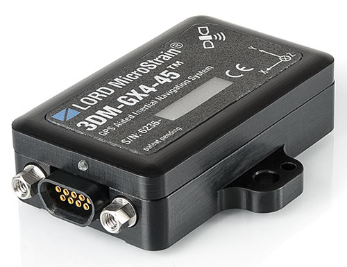
The 3DM-GX4-45 by LORD MicroStrain is a miniature, industrial-grade GPS-aided inertial navigation system that uses high-performance MEMS sensor technology. It combines a triaxial accelerometer, triaxial gyro, triaxial magnetometer, temperature sensors, pressure altimeter, and dual on-board processors running a sophisticated Extended Kalman Filter (EKF) to provide excellent position, velocity, and attitude estimates.
It offers a range of fully calibrated AHRS measurements, including acceleration, angular rate, magnetic field, deltaTheta and deltaVelocity vectors. GPS measurements include LLH position, ECEF position and velocity, NED velocity, UTC time, GPS time, and SVI. The receiver is a 50-channel u-blox 6, which receives GPS L1 C/A code, and the SBAS signals WAAS, EGNOS, and MSAS.
The 3DM-GX4-45 provides accurate navigation and orientation under dynamic conditions for applications such as GPS-aided navigation; unmanned vehicle navigation; camera stabilization; robotic control; and reconnaissance, surveillance, and target acquisition.
The European-focused imaGIne conference will provide attendees with an opportunity learn what is going on in the geospatial sector and to network with important decision-makers. EUROGI’s “imaGIne: Opportunities Everywhere” Conference will be held October 8-9 in Berlin, Germany.
The imaGIneconference will take place at the same venue and at the same time as the InterGeo trade fair.
A key aim of the conference is to showcase the best that Europe has to offer in the geospatial field, thus the conference subtitle “Geographic Information Expertise: Made in Europe.” The aim has guided EUROGI and its member associations in the selection of themes and speakers, organizers said.
Plenary Sessions and Keynotes
During the plenary sessions, presentations will be given by top European and global experts.
Roberto Viola, deputy director, Directorate General CONNECT, European Commission, will provide an outline of the European Union’s Digital Agenda Europe, with particular emphasis on geospatial aspects.
Detlef Dauke, director general, German Federal Ministry for Economic Affairs and Energy will speak on behalf of the German vice-chancellor, who is the patron for the conference.
Two speakers will provide a view of the state of the European geospatial industry from a global perspective, highlighting its strengths, weaknesses, opportunities and threats. Other issues which will be covered in the plenaries include the Internet of Things (billions of interlinked sensors across Europe), Linked Data (joining up data which was otherwise unconnected) and Big Data (massive amounts of data from diverse sources and across many fields).
In addition to the plenary sessions, there will be 15 parallel sessions of 90 minutes each, each of which has a specific thematic focus. The themes include Job Creation and Economic Growth, Energy, Environment, Demography, Smart Cities, Copernicus (Europe’s Earth Observation initiative), Open Data, Big Data, and Insurance. The sessions will not only provide interesting insights, but will also feature panel sessions with discussions of pertinent issues, as well as opportunities for audience engagement.
The European Commission’s Joint Research Centre will provide an opportunity to discuss the European Union Location Framework, a set of policies and measures which aim to facilitate the integration of geospatial information into e-government services and to increase alignment in and between existing and future EU policies.
InterGeo Fair. InterGeo is the world’s leading trade fair for geodesy, geoinformation and land management. With over half a million event website users, over 16 000 direct visitors each year from 92 countries and more than 500 exhibitors, it is one of the key platforms for business dialogue in the geospatial information sphere.
Registration for EUROGI’s imaGIneconference will automatically entitle delegates to visit the fair.
More information about the conference can be found at www.imagine2014.eu. The website also provides the opportunity to register. An early-bird discount rate will be available until August 31.
The Geospatial Sector — Huge and Growing Fast
Geospatial information, also often referred to as geographic information, is any information that has a location/position “tag.” The tags can take many forms, including for example, postal codes, street addresses, words that have a location/place reference (such as Barcelona, the Rhine, Slovenia, etc.), north/south coordinates, and more. Organizing and managing tags enables vast amounts of otherwise disparate information to be integrated and new and innovative insights and services to be provided.
According to a report published last year by Oxera, a leading UK economic research firm that was commissioned by Google, at $150-270 billion annually the geospatial sector globally was one third the size of the global airline industry. (See “What is the Impact of Geospatial Services?”)
The report states, “Geo services are making an important contribution to the global economy and to future productivity. The efficiency gains they create are helping to facilitate future economic activity and generate additional consumer welfare.”
Everyone is aware of the airline industry, but very few are aware of the geospatial industry, an industry that to a very large extent operates out of direct public view, but that produces products and services that impact on billions of people worldwide on a daily basis. The insurance, automotive, telecommunications, navigation, marine, agriculture, energy, utilities, tourism, and recreation and media industries are just some of sectors that rely heavily on geospatial products and services.
Apart from the enormous size of the sector, another key point highlighted in the Google-sponsored research report is that the sector is growing globally at about 30 percent annually. With overall global economic growth taking place in the lower single-digit range, growth of this nature can truly be described as explosive, conference organizers said.
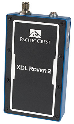
Trimble has introduced the Pacific Crest XDL Rover 2, an advanced, high-speed, wireless data link built to withstand the rigors of GNSS/RTK surveying and precise positioning.
The XDL Rover 2 is equipped with Bluetooth wireless communication for ease in configuration and operation. It can be quickly configured with an Android device in the field and UHF data can be transmitted via Bluetooth to a paired host device for operational efficiency.
The XDL Rover 2 is a lightweight, ruggedized UHF receiver designed for digital radio communications between 403 and 473 MHz in either 12.5 or 25 kHz channels. It is designed for high performance over the entire band. The XDL Rover 2 is pocket sized and provides for cableless operations. It features an internal, rechargeable battery for ease of use and portability that allows long operational hours.
“The XDL Rover 2 is an ideal, high-speed radio receiver for field operations that require a one-way communications link,” said Jess Cobb, business area director for Trimble’s Radio Communications Group. “Its interoperability with existing equipment and greater functionality allow customers to rapidly deploy the XDL Rover 2 for maximum productivity.”
This sophisticated radio leverages the latest generation XDL modem technology while remaining backward compatible with existing Pacific Crest and other products. By deploying the technology, users can instantly communicate with GNSS precise positioning receivers that share the same protocols throughout the world.
The XDL Rover 2 joins the line of XDL products that includes the XDL Micro, a transceiver OEM module. The XDL Micro is a 0.5-2.0 Watt UHF transceiver designed for integration into products that require either a one- or two-way radio communication link. The XDL radio line is based on the successful Pacific Crest ADL products.
Trimble has added advanced line acquisition technology to its Autopilot automated steering system Trimble OnSwath technology. The acquisition technology reduces the time lost turning at the end of a row by enabling the vehicle to make a tighter turn and approach the next line, or crop row, 50 percent faster.
Using OnSwath, the farmer can decrease idle driving time, fuel consumption, soil compaction, crop damage, and working time in the field — which can lead to cost savings. OnSwath is a free upgrade to customers using the Trimble Autopilot automated steering system.
The new OnSwath technology allows the user to customize their line acquisition to the vehicle, operation, and operator preference including adjusting turn angle, approach angle, and speed. Using OnSwath, the vehicle projects its path to the line, which allows it to get online faster. As a result of these improvements, vehicle performance is more controlled, predictable, and repeatable.
“By adding OnSwath to Trimble’s Autopilot steering system, we’ve enabled farmers to be more efficient with their field operations,” said Erik Ehn, Smart Machines business area director of Trimble’s Agriculture Division. “OnSwath saves time, money and fuel, while also decreasing soil compaction and crop damage. Since we’re providing the technology at no additional cost, farmers who use Trimble’s automated guidance can leverage OnSwath and measure how much it can save their farm.”
“With Trimble’s OnSwath, I’m able to get online much faster and more accurately,” said Joe Brightly, who began using the OnSwath technology this spring for planting and strip tilling operations. “After an end of row turn, I can get online in a matter of only a few feet, which has saved me a lot of time.”
OnSwath is available with a software update to the Trimble Autopilot system.
A new app from Esri called Explorer for ArcGIS puts mobile mapping and geographic content sharing at your fingertips.
Available right now for use on your Mac or iOS device (a version for Android is coming soon), you can use the app within your organization to find maps, locate assets and other geographic content, and share map presentations with colleagues. The interface is intuitive and requires no geographic information system (GIS) experience.
To become familiar with the app, tune in to the Esri live training seminar Boost Productivity with Explorer for ArcGIS. The presenters will show you how to use the app and share your data with other Explorer for ArcGIS users.
Esri.com/lts August 14, 2014
9:00 a.m., 11:00 a.m., and 3:00 p.m. (PDT)
After viewing this seminar, you will understand how to:
search for, discover, and explore your authoritative geographic data.
view asset information.
search for places and features in maps.
share your maps.
sketch on your maps to highlight important aspects of your data.
tell stories and brief stakeholders using map presentations.
This seminar will be of interest to those who want to share their authoritative content with anyone within their organizations, including executives, managers, and knowledge workers.
Explorer for ArcGIS is included with ArcGIS, so download the app from the Apple App Store, the Apple Mac App Store, or the ArcGIS Marketplace. Then open the app and sign in to your ArcGIS account. You will need a broadband Internet connection and an Esri Global Account to watch the live training seminar. Creating an Esri Global Account is easy and free: visit esri.com/lts, click Login, and register your name and address.
A few weeks ago at the Esri 2014 International User conference in San Diego, California, we conducted our first live event webinar from a Plexiglas booth sitting among many of the 14,000+ attendees buzzing around inside the San Diego Convention Center.
The webinar focused on high-precision GNSS on mobile devices (iOS/Android/Windows), unmanned aerial systems (UAS), and real-time GIS transactions. These are hot topics in the geospatial world, and that was confirmed when I received about 100 pre-webinar questions and more than 100 post-webinar questions.
In my article this month, I’ll do my best to provide answers to the questions asked. If I don’t get to your question, or if you have another, please email me at [email protected].
First of all, if you didn’t attend the webinar and would like to view the recording, you can register here and you’ll be provided a link to view it. It’s a great, interactive discussion. I grabbed Sharad Garg, iOS consultant, from the Esri show floor to talk about the intricacies and complexities of using GNSS receivers on iPads and iPhones.
Without further delay, following are some of the more popular pre- and post-webinar questions I received.
Mobile Devices
First, I’ll start with the questions about mobile devices and high-precision GNSS.
1. Will Android be the dominant mobile tablet platform in the Enterprise?
It’s hard to say. I recently met with a group of enterprise IT professionals and we were discussing this issue. Basically, the group was equally divided into thirds. One third were using Android. one third were using iOS, and one third were using Windows.
Android advantages: Lots of mobile devices available that run Android. Android disadvantages: Open source = non-standard implementations, so app software may not run on every device; security concerns.
iOS advantages: Consistent user interface, consistent software development environment, popularity of iPad and iPhone. iOS disadvantages: Closed ecosystem (very limited number of tablets); doesn’t interface to devices (such as GNSS) that haven’t been through the Apple certification process; security concerns.
Windows advantages: Security; lots of legacy apps and utilities written for Windows. Windows disadvantages: Limited number of tablets being deployed based on Windows.
For enterprise organizations, data security is a huge concern. Since Android is open source and gaining the most market share (at least in the consumer market), it’s got a target on its back for hackers. That’s the biggest concern I hear from corporate IT professionals. How will Android device developers address that, or will they? The consumer market for Android devices is exploding regardless of security. Do they even care about the enterprise market? Apparently Apple does as it recently signed an agreement with IBM to address the enterprise market, with IBM committing to deploying more than 100 enterprise solutions for iOS.
Site of the webinar broadcast from the Esri UC.
2. Which mobile platform is the most universal/easy to integrate with GNSS receivers?
Out of the box, Windows and Windows Mobile devices are still the easiest to interface to external GNSS receivers for the average consumer. Using Bluetooth, serial or USB, NMEA (or proprietary binary) data flows easily via the device com port or virtual com port. If you’re using a Bluetooth interface, there is some inconsistency among mobile devices due to the different versions of Bluetooth management software used on mobile devices, but it’s workable, and worst case you can buy an inexpensive third-party Bluetooth software manager like BlueSoleil.
With the use of an app such as Bluetooth GPS that allows you to select an external GNSS receiver, connecting your Android device to an external Bluetooth GNSS receiver is relatively painless.
Apple products are the toughest to integrate with external GNSS receivers via Bluetooth. Each GNSS receiver has to be specifically designed with an Apple Bluetooth authentication chip and be subjected to the Apple certification process, which can be lengthy and costly. This is the reason why you see very few Bluetooth GNSS receivers available for Apple products. The good news is that once the GNSS receiver is approved, the Bluetooth connection happens automatically when the GNSS receiver is in range of the Apple device. No com port config, no baud rate to worry about, etc.
3. What is available on Android that will make my smartphone a practical and useable tool that can assist in collecting professional data?
First of all, you need to find a high-precision Bluetooth receiver to connect to your Android device. Then, establish the Bluetooth partnership between the Android and GNSS receiver (scan for Bluetooth devices, enter passcode, etc). Once you have that, download the Bluetooth GPS utility I mentioned above and it will allow you to select which GNSS device to use (external vs. internal). Once you’ve selected the external GNSS receiver and connected to it via Bluetooth, every location app on your Android device will use the high-precision GNSS receiver for location.
This applies to an Android tablet or Samsung Galaxy phone. Take a look at this article to see how I ran RTK on a Samsung Galaxy using a Bluetooth RTK receiver.
Today’s challenge is finding “professional” GIS data collection apps that run in the Android environment. There are a few, but the selection is limited. Esri has its Collector for ArcGIS app that runs on Android, but it requires an ArcGIS server backend or ArcGIS Online account. Other data collection apps like Fulcrum and Amigocloud run on Android as cloud-based services.
4. Is there an actual GPS receiver within smartphones, or are they triangulating off of cell towers?
There’s a GNSS receiver in virtually every smartphone manufactured. The GNSS chips are so cheap (a few dollars) compared to the functionality gained that it wouldn’t make sense not to design a GNSS receiver in a smartphone. Now, just because there’s a GNSS chip in each smartphone doesn’t mean it’s the only technology used for location. For example, Apple iOS uses multiple data sources to determine the location at any given time. It will use a combination of cellular triangulation, Wi-Fi IP address, and internal GNSS receiver and external GNSS.
5. Which applications do you see requiring RTK accuracy within the mass-market applications?
A couple of years ago at the GPS World Leadership Dinner at the ION GNSS conference in Nashville, Dr. Todd Humphreys of the University of Texas at Austin predicted that you’ll have RTK (real-time centimeter accuracy) capability on your smartphone by the year 2020. I agree with his prediction, and I think we’ll see inexpensive Bluetooth RTK “pucks” well before 2020, as I’ve written before.
Often, I get the question raised above. Who needs RTK on a mobile phone?
I can’t tell you any more than that in the early 1970s when GPS was first being conceived, not one could tell you what GPS would be used for today. I love the following quote from Steve Jobs: “People don’t know what they want until you show it to them.”
6. Since many devices are complete systems with GNSS inside, do you see the direction of the industry moving towards remote “add-ons” like Bluetooth receivers?
Bluetooth receivers are certainly trending, and it’s primarily driven by the explosion of powerful yet inexpensive tablets and smartphones in the past five years, starting with the iPad/iPhone, and now with Android devices and smartphones in general. People want to use their consumer devices in a professional capacity and some need high-precision GNSS receivers, so that’s driving the demand for “add-ons” like Bluetooth GNSS receivers, laser rangefinders, and more.
Unmanned Aerial Systems
Ok, let’s transition to some questions on UAS (such as UAV, drones).
1. Do you see the FAA allowing simple operations for very low altitude UAV-sensors?
It’s difficult to speculate what the FAA will implement, but I have to think, based on its past behavior, that the initial rules will be super-conservative with minimum requirements being that a licensed pilot will be required to operate the UAS in addition to strict equipment requirements.
What’s going to be interesting to observe is what the FAA will do about the hundreds (maybe thousands) of UAS operators who will attempt (or are attempting) to “fly under the radar” and skirt the FAA rules. We’ve seen the FAA attempt (sometimes successfully and sometimes not) to crack down on some UAS operators whom it believes are violating the rules, but there have only been a handful of those cases.
2. When do you think the FAA will release rules for commercial UAV users?
I wouldn’t be surprised if the FAA issued some guidelines in September 2015, but I seriously doubt they will publish the full set of rules by then.
By the way, I attended an interesting UAS presentation at the AEC Summit prior to the Esri UC. You can see my write-up of it here.
That’s it for now. I’ve got many more questions from the audience that I’ll address in upcoming newsletters. Stay tuned and feel free to email me directly at [email protected].
Proteus FZC, a provider of satellite-derived mapping and classification services, has launched a fast-turnaround habitat mapping solution designed specifically for Environmental Impact Assessments (EIAs). Through the service, Proteus delivers high-resolution classification maps of terrestrial areas onshore and the seafloor in shallow-water marine environments.
“Energy and infrastructure development projects are under intense pressure to delineate fragile habitats onshore and in the coastal zone as part of their EIA submissions,” said Proteus CEO David Critchley. “The accuracy of these maps determines budget levels for environmental protection and remediation efforts.”
The Proteus habitat mapping service can be completed in a fraction of the time and is cost effective compared with traditional mapping methods, the company said. The solution is designed for use by engineering and construction firms, environmental consultancies and government agencies involved in the development of energy infrastructure, pipelines, power stations, desalination plants, port facilities and other projects where EIAs are mandated.
Mapping sensitive marine habitats in the coastal zone is a particularly challenging aspect of EIA preparation, explained Critchley. Divers are typically deployed to collect hundreds of ground truth points underwater, which are later used to delineate the boundaries of various habitat or land cover types on the seafloor. This process is time consuming, logistically complicated and does not provide a full picture of the sea-floor environment.
“In addition, many marine environments are simply too dangerous or difficult for ground-truthing crews,” Critchley said. “And that can be true onshore as well.”
For its mapping solution, Proteus obtains high-resolution multispectral imagery from commercial imaging satellites, such as DigitalGlobe’s WorldView-2 platform, which are capable of quickly capturing data anywhere in the world without the limitations of aircraft and ships. Proprietary processing techniques derive accurate land cover and seafloor classifications from the image data for generation of habitat maps.
“For seafloor and terrestrial areas, we deliver habitat maps with horizontal accuracy of five meters,” Critchley said. “The quality and information content of these maps far exceeds those traditionally submitted with Environmental Impact Assessments, and satellite image is included in the deliverables.”
Offshore, the habitat classification process is accurate to a depth of up to 20 meters, depending on water clarity. The minimum mapping unit varies with the client needs and resolution of satellite imagery. Satellite-derived bathymetric data is also offered as a product of the technique.
Since 2011, Proteus has been delivering solutions for mapping and classification projects using multispectral satellite imagery. These mapping projects have been delivered for environmental, oil & gas, engineering and other coastal zone applications in Europe, the USA, the Middle East and Caribbean.
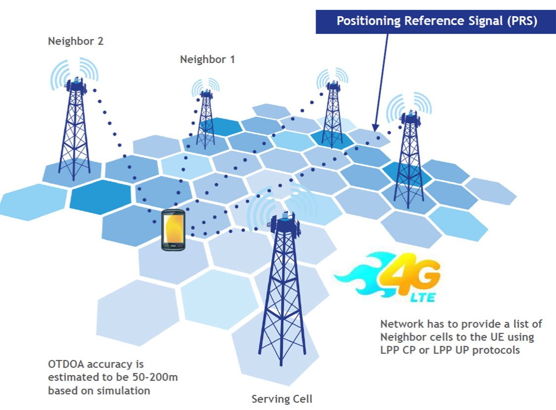
LTE brings a promise of improved location accuracy with new positioning technologies and their integration using hybrid techniques. Although established technologies such as A-GNSS (A-GPS and A-GLONASS) provides excellent performance in environments with a clear view of the sky, performance is often poor indoors, where detection of satellite signals is limited. In LTE, current standards support Observed Time Difference of Arrival (OTDOA), an advanced cellular positioning technology that can augment A-GNSS and provide a more accurate location fix for indoor scenarios.
With large-scale VoLTE rollouts imminent, leading operators are confronted with the need for extensive and complex testing of LTE positioning technologies to ensure VoLTE E911 works well from day one. Additionally, the FCC, whose current E911 regulations apply only to outdoor environments, has proposed stringent indoor requirements as a response to increased mobile usage for emergency calls and lack of accurate positioning information on calls that originate indoors.
“Roughly 70 percent of 911 calls are placed from wireless phones and a majority of these calls originate indoors, so there is a real urgency in providing better location accuracy for mobile users, wherever they are calling from,” said Nigel Wright, vice president at Spirent Communications. “Spirent is currently working with all the key industry players to evaluate OTDOA and its integration with other positioning technologies, and to enable operators to meet the location requirements for VoLTE E911 and the evolving FCC requirements.”
Spirent 8100 LTS has won widespread acceptance as the leading platform for location testing in the wireless industry, and with this latest capability is now able to support OTDOA Position Calculation Function (PCF). Minimum performance testing for OTDOA looks only at the raw measurements from the device, whereas use of OTDOA PCF enables full verification of a device’s position accuracy performance. Recognizing its importance, leading carriers have established their own OTDOA positioning performance requirements beyond bare minimum standards. Ensuring that devices fully meet these requirements as well as the evolving FCC regulations for E911 requires comprehensive testing.
“The Advisory Council is comprised of foundation members selected because of their unique expertise, background and reputations within the international navigation and timing community,” said Dana Goward, president of the foundation.
While the council will advise the foundation on an on-going basis, in-person meetings will be scheduled to coincide with those of the U.S. National PNT Advisory Board.
The RNT Foundation Advisory Council membership includes Donald Jewel, GPS World Defense Editor and United States representative; Chuck Schue, also from the U.S.; Refaat Rashad from Egypt; David Last from the United Kingdom; and Krzysztof Czaplewski from Poland.
Mitre’s new Time Anomaly Detection Appliqué (TADA) protects modern digital systems from spoofing attacks that can corrupt time source signals.
Successful spoofing attacks could result in navigational systems going haywire and grounding airplanes, jumbling of buying and selling orders, a shutdown of the stock market, or power-grid failures. Infrastructure and defense systems often rely on GPS’s unencrypted position, navigation, and timing (PNT) signal as their source of accurate time, accurate to about 14 nanoseconds.
The TADA system detects and, for certain users, mitigates timing attacks. “Almost every system has a need for precise and accurate time,” said Darrow Leibner, the Mitre TADA project lead. “Because GPS is accurate and ubiquitous, users have gotten away from implementing other time-keeping methods. That’s where the potential vulnerability comes in.”
TADA is designed to provide a cost-effective, reliable, and easy-to-use method for protecting GPS receivers against spoofing attacks. The system defends against spoofing by continuously comparing a trusted input, such as a known frequency or location, with those provided by the GPS receiver. When a difference between these two inputs is detected, TADA alerts the user to the suspected PNT anomaly.
For a trusted input, TADA uses an atomic clock frequency. For each second measured by the incoming GPS timing signal, TADA counts the number of frequency cycles generated by a Cesium clock. If the incoming GPS signal is valid, TADA will count exactly the expected number of Cesium frequency cycles. If TADA measures a higher or lower number of timing signals than expected, it will display the difference. A difference outside the acceptable margin of error will prompt TADA to alert its users that the GPS timing signal is possibly being spoofed.
In the same way it uses a trusted time source, TADA can also use a known location to detect a spoofing attack. To do this, the user inputs the location of a GPS receiver antenna into TADA. TADA monitors the reported position for any changes. Any reported change of the stationary location would most likely be due to spoofing attack and prompt an alert to the user. Once alerted by TADA to a spoofing attack, users can quickly switch to existing backup systems.
“This is not the invention of the lightbulb,” Leibner said. “Rather, it’s a clever use of existing technologies packaged in such a way that users obtain a greatly increased level of protection for a minimum of investment. None of the TADA components on their own are brilliant. But as one manufacturer said after seeing a detailed description of TADA, ‘It’s brilliantly simplistic.’”
The next stage in TADA’s development is to provide it with the capability to not only detect spoofing attacks, but to mitigate its effects and pinpoint their origin. Mitre will also continue to advocate that to bolster the nation’s infrastructure defenses against spoofing, TADA-like monitoring techniques be included within commercial product design.
Topcon Tesla handheld controller combines the advantages of a PC tablet with the ruggedness of a fully equipped survey device.
An Oklahoma Survey Firm Is Increasing Productivity with Cloud-Based Solutions
By Larry Trojak
Until recently, the flow of real-time information and job-critical data between the office and personnel in the field for survey and construction has not kept pace with advances in onsite GNSS equipment. But enterprise software suites are closing the gap, producing across-the-board efficiencies, cost reductions, and an ability to bid more competitively.
Sisemore Weisz & Associates (SW&A) of Tulsa, Oklahoma, is an engineering specialist in site design and land planning, and has survey experience with ALTA/ACSM work, high-end civil construction, structural layout, and large survey control networks. Topcon’s cloud-based software suite Magnet gives SW&A the ability to have immediate access to the plans, data, and site information needed to respond to and complete the job.
“Providing the ability for any crew to immediately access their data from anywhere via a Tesla field tablet is invaluable. It’s literally changed the way we do business,” said SW&A chief of parties Shawn Collins.
Collins’ ultimate goal was to establish a platform for data collection, sharing, and transfer that best utilized today’s technology, including Internet access and the ability to email and text message crews in real-time.
His first instinct was that a tablet such as an iPad might be the answer, but iPads weren’t suitable for surveying Instead, they chose Topcon’s newly introduced Magnet Enterprise package along with a pair of Tesla controllers. Finding it the right solution, after a few weeks they bought more Teslas. “It was just the solution we needed,” Collins said.
Magnet Suite
Comprised of three individual software components — Field, Tools, and Office — as well as the Enterprise cloud environment itself, the Magnet suite of products is designed to bring real-time, cloud-based efficiency to any survey or construction operation, according to Jason Hallett, Topcon’s senior product manager for software applications.
“Magnet considers everything from data collection, to CAD, to data manipulation and reporting, to data exchange, to cloud-based project management in an enterprise environment,” Hallett said.
Components of Magnet:
Field. Connects field users to the cloud, and enables real-time communication, as well as cloud storage and data exchange. A powerful field software for topo, staking, roads, and calculations is included.
Tools. Allows the processing and exchange of data between the enterprise cloud and popular desktop applications, such as Autodesk Civil 3D.
Office. Exchanges design files, survey jobs, and surfaces through the enterprise cloud for simple project revisions and real-time survey data from the field.
Dillon Dossey is a one-man crew with Magnet and the cloud.
In the year since they began using Magnet, Collins said that the system has become an integral part of the way SW&A does business. “It can be something as simple as getting a crew working faster than we ever could in the past,” Collins said. “For example, say we are set to begin a large highway project several hours from the office, but we are wrestling with plans or have calculations that still need fine-tuning on one part of the job. In the past, the whole project would have been held up until those issues were resolved. Now, we can send a crew out with what we already have and, when that missing data is completed, upload it to the cloud for them to access when they need it. As a result, production is on track, deadlines are met, and the customer is pleased.”
Re-routing crews — a time-consuming effort in the past —is now a simple process. “If a crew wraps up a project and needs to be re-routed from their original follow-up job, they now can simply check email or chats on their Tesla and see what’s changed. All of their pertinent information is going to be in the chat and in the cloud — all the directives are there, all the paperwork, everything they need to make a fast, seamless transition to the next job without having to come back to the office. Just minimizing those trips back here has shown us a nice 14 percent reduction in fuel costs since going forward with Magnet. And taking that 14 percent off of a bid allows us to be that much more competitive.”
As chief of parties, one of Collins’ primary roles is quality control on projects, and Magnet has helped. “I can show up to a site to see how a crew is doing, have them upload data to the cloud, and confirm their progress. As a result, managing the parties, managing the control, managing the job flow is so much better. And, contrary to what one might think, the fact that the crews know they are being checked has not had any downside at all. They know we are all on the same team and appreciate that this technology is helping make us more competitive — which ultimately benefits everyone.”
Collins has witnessed dramatic changes in his 30 years of surveying, but sees Magnet as a game-changer for data management and flow, the exchange of information, and bidding on jobs which, thanks to Magnet Enterprise’s cloud-based environment, has become a streamlined, efficient process.
“It is now possible to easily cross-reference jobs to help in the bidding process,” he said. “We can go into our cloud and see if we did a similar job before, and, if so, view the work order, view the billing files, see how much that job actually cost, see what we bid on it, see if we were profitable, see how we did for time management, and so on. In the past that would have been a painstaking, time-consuming process. But with that all data readily at hand, it is easy to put together an informed, competitive bid and get it out to the client in no time.”
One area that Collins hopes to pursue further is deeper client involvement. “We recently added 5 GB of capacity to our cloud storage, and that should help us move forward with that push. Making it possible for the client to look at the project as it exists in real-time, to be able to review and red-line items or discuss issues, and do so without a trip to our office will be a real plus.”
One-Man Crew
A visit to a local development called Yorktown finds a single rod man, Dillon Dossey, at work, a typical scenario for SW&A. “This is a 120-lot development, and Dillon has been the sole SW&A person on this job since the outset, surveying and staking to rough in roads for the developer, and he will be here until our portion wraps up,” Collins said.
With Topcon’s PS-103 robotic total station (SW&A’s latest purchase), his Tesla, and Magnet — which is also built into the total station — Dossey can operate as a one-man crew with confidence, Collins said. “If Dillon gets into a situation where he suspects something is wrong or he needs help deciding something, he doesn’t have to break down his equipment and drive all the way back to town; he has everything he needs right there with him. He has the data, he can chat with me, with the office, and we can send data right back to him.”
Dossey offered his take on Magnet’s impact on his role at SW&A. “We are working toward eventually eliminating the need for us to go back to the office at all,” he said. “If we have to, we can come in to get gear in the morning, but that’s about it. However, right now, if I am halfway through a job and Shawn contacts me to head to another one, he just sends me all the info I need and I’m on my way. It is very cool. The amount of data that we can exchange back and forth through the cloud is just startling.”