Trimble has introduced a new version of its office software suite used by surveyors and geospatial professionals for processing and analyzing geospatial data. Trimble Business Center Version 3.21 introduces new coordinate reference systems and a specialized Advanced Drafting module, which enables faster project turnaround and better decision making.
The optional Advanced Drafting module adds highly customizable templates and simplified selection tools, which are designed to reduce the time required to generate high-quality deliverables, such as geospatial maps and corridor cross-sections. Now, professionals working on road, pipeline, and railway projects can achieve efficiency gains through the software’s new automated cross-section plotting functionality.
Also included in the new module is the ability to create 3D PDFs so that team members and clients can collaborate from any computer or mobile device using Adobe Reader software.
“Trimble Business Center is the enterprise solution for surveyors and geospatial professionals to produce high-quality deliverables,” said Alain Samaha, business area director of GIS and Software for Trimble’s Geospatial Division. “These new capabilities demonstrate the continued evolution of our software portfolio to provide customers with an end-to-end solution to fulfill their client’s high-end requirements in the most efficient way.”
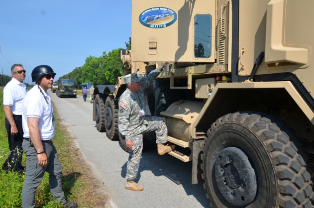
The U.S. Army Tank Automotive Research, Development and Engineering Center (TARDEC) and Lockheed Martin successfully demonstrated additional capabilities of the Autonomous Mobility Appliqué System (AMAS) May 29 at the Department of Energy’s Savannah River Site in South Carolina.
They conducted a driverless line-haul convoy with seven military trucks at speeds up to 40 mph.
The AMAS CAD II demonstration built upon capabilities demonstrated at Fort Hood, Texas, in January, when three unmanned military trucks negotiated oncoming traffic, followed rules of the road, recognized pedestrians, and avoided various obstacles at speeds up to 25 mph in an urban environment.
AMAS is a Joint Capability Technology Demonstrator, or JCTD. That means it’s a joint program between the U.S. Army and the U.S. Marine Corps. The AMAS common appliqué kit consists of the bi-wire active safety kit and the autonomy kit. It uses GPS, lidar systems, Automotive radar, and commercially available automotive sensors to make the system affordable. The AMAS JCTD goal is to standardize these kits across both the Army and Marine Corps and give the warfighter the ability to transform ordinary vehicles into optionally manned vehicles.
Colonel Bruce B. McPeak, Director of Materiel Systems, Combined Arms Support Command, climbs into a Heavy Equipment Transporter (HET) for an autonomous ride-along.
TARDEC is working closely with the U.S. Army Training and Doctrine Command (TRADOC), military users, and the acquisition community to advance the development of autonomous appliqué systems for tactical vehicles and make these capabilities available by 2020.
Autonomy-enabled vehicles will reduce accidents while augmenting the warfighter, and increase capabilities by creating greater stand-off distance from danger, which would make supply distribution safer and more efficient, and provide the flexibility to adapt to tomorrow’s ever-changing and evolving threats.
“The driverless vehicle is coming in both commercial and military applications,” said Bernard Theisen, TARDEC’s AMAS Technical Manager. “The Army is at the forefront of this technology.”
Military and industry VIPs drove alongside the convoy in a bus to watch the unmanned convoy demonstration.
The 30th Space Symposium offered a lot to see and do.
I have said before and will undoubtedly say again, there is absolutely no space-related event in the world today that approaches the sophistication and professionalism of the Space Symposium held annually in Colorado Springs, Colorado, at the five-star Broadmoor Resort. The Space Symposium, carefully engineered and meticulously overseen by the Space Foundation, is truly the premier, must-attend space event of the year on a global basis.
I have been honored to attend 27 of the 30 symposiums, and I hope to attend many more before I shuffle off this mortal coil. Believe me when I say this; it is not merely an oblique reference to health issues. I was hospitalized for four days afterwards with exhaustion among other issues, and the chairman of one of the key companies in space today now has walking pneumonia. So, while this is a major event, you can overdo it, but that is a personal issue and not by any means the fault of the Space Foundation or the event sponsors. Instead, it is an affirmation of the quality and necessity of the event. Indeed, the Space Symposium, with an average attendance of 9,000+, has grown to the point that a single individual just cannot take it all in. It is just not physically possible, whether you are 25 or 65 — believe me, I tried.
Therefore, planning your time at the Space Symposium is essential. Unlike many symposiums where you are able to “play it by ear” and take events as they come, at the Space Symposium if you don’t plan well you will truly miss some crucial space-related event. Plus, it is difficult to relate the quality of the networking opportunities. You have access to space professionals and company VIPs at the Space Symposium that you would never be able to contact in normal daily business circumstances, and the beauty of it is they don’t have an office to escape to. There are so many additional cultural and social events that most VIPs attend, so if you don’t contact your target company VIP, it is probably just for lack of trying. Having said that, it is always good to have your elevator speech polished, because your quantity of time may be limited. You must take advantage of every opportunity. And no matter how well you plan, there are always those chance encounters, which is one of the aspects that make the Space Symposium so worthwhile. Sometimes just the opportunity to rub shoulders and discuss space matters with other professionals is all that’s required; those opportunities were abundant at this year’s symposium.
May Day versus April Fool’s Day
This year circumstances prevailed, and the 30th Space Symposium was held 30 days later than normal. The events that led to that scheduling change are significant in their own right. For instance, I will list just a few events and names; they might initially seem random, but they are intricately related:
Phil Anschutz
Broadmoor Resort
Construction
Renovation
Colorado weather
School schedules
Graduation dates
Space legislation
Sequestration
Colorado governor
Ambiance
Consistency
Education
OK, the list could go on and on, but the point is that the Broadmoor Resort, as a resort, has been around since 1918, or 96 years. The property history actually goes back as far as 1871 and the founding of Colorado Springs by Spencer Penrose, but that is another story for another time. The most recent important facts are that in October 2011, Mr. Philip Anschutz, a local Denver-based billionaire, purchased the Broadmoor, a place he fondly remembered from his childhood. He decided that it needed renovating in the best style of the early 1900 Italian Renaissance — which was always reflected in the older resort buildings on the eastern side of the lake, but was not reflected in the newer western side, with a lack properties. Consequently, the two-plus-year renovation certainly impacted the dates and availability of rooms and services available for the annual Space Symposium. In 2012-13, the event took place in spite of construction, but the 2014 date needed to be moved from April to May to ensure all facilities would be available. Indeed, the formal completion and grand opening after renovations took place was on the Friday preceding the Sunday opening of the Symposium. But then, close only counts in love and horseshoes.
So this accounts for a few words on the list, but the rest are definitely related to the conference itself. For years, many of the non-Colorado space companies and sponsors of the symposium wondered aloud if the second week in April in the foothills of the Rocky Mountains might be a bit early for such an event, since it invariably snowed, usually more than once, on participants sometime during the week-long event. However, the Space Foundation held firm on the dates for many reasons, one of which was the belief that flatlanders just don’t understand that the foothills of the Rocky Mountains are eligible for snow 12 months out of the year. Seriously, we have lived here for going on 25 years now, and we always said we were eligible for snow 11 months out of the year until a couple of years ago, when it snowed ten inches in August. It had been 80+ degrees the day before. So the Space Foundation pretty much ignored the clueless flatlanders and stuck to their guns on the date issue.
But, in all honesty, there is much more to the date debate. The Space Foundation prides itself on education and fostering interest in all things space related. It helps fund numerous space-related institutions, scholarships ands organizations. The future of space and our national heritage as it relates to our future space professionals is a consuming force in the Space Foundation’s mission. In May, most schools in the Rocky Mountain region have been dismissed for the year, and quite frankly, as they discovered this year, the space symposium is significantly diminished if the students, teachers and professors cannot attend. This year the attendance was down almost 2,000 attendees, from 9000+ to 7000+, simply because schools and educators from grade school to graduate school found it difficult to participate. Be that as it may ,the Space Foundation could not ignore Philip Anschutz and the multimillion-dollar Broadmoor renovation, nor the major inconvenience to the guests and attendees. So they reluctantly agreed to move the date to May as a one-time experiment.
The results of that experiment were definitely mixed. On the plus side, the renovations were complete and the transformation was phenomenal — if you had never visited the Broadmoor before, you would not be able to tell anything was changed. Facilities and buildings on both sides of the lake look like they were built in the early 1800s, but with all the modern conveniences of the 21st Century — a truly amazing accomplishment and tribute to Phil Anschutz’s vision. I visited the Broadmoor at least once a month during the two-year renovation, and I was still amazed at the transformation. Nineteenth-century Italian ambiance and 21st-century convenience, what a combination.
Now to the weather. Indeed, there were only a couple of small snow showers in the early morning hours during the week at around 0500, which most everyone missed. But Wednesday’s monstrous mega-hailstorm happened in the middle of the afternoon and was not to be missed, visually, aurally or physically. I was enroute to a meeting with Dr. Mark Crews and company from Ball Aerospace on the East side of the lake when the meteorological freight train struck. Fortunately I was under a huge Broadmoor umbrella at the time, or would have surely suffered a concussion, and that is no exaggeration. Golf-ball-sized hail appeared in biblical proportions (Moses would have been proud), and insurance companies executives, many who were in attendance, could be seen talking rapidly on phones and groaning visibly. Indeed, USAA, my insurance company for the last 50+ years, reported more than 800 automobile and 400 property insurance claims in a 24-hour period following the storm, and many insurance companies sent in their disaster and catastrophe teams. So, all in all, I vote for the occasional light snow in April versus the icy rocks raining from heaven in May. I know it is an anthropomorphic illusion, but it is as if Mother Nature were thumbing her nose at those flatlanders who dared be critical of a few snowflakes in April. On the plus side, the added moisture ensured the fireworks display could take place as planned this year, and it is always a spectacular event over the Broadmoor Lake.
Politically Speaking
Politically, the timing could not have been better for the Governor of Colorado, the Honorable John Hickenlooper, who came south of the Mason-Dixon line and attended the event where he ceremoniously signed significant Colorado State tax legislation that — bottom line — makes it more profitable for all space-related companies to operate in Colorado. Colorado currently ranks third in the nation for space-related income. Many believe it will return to the Avis, or number-two, spot that it held for many years, after this legislation has time to take effect. Current rankings are California first, Florida second, and Colorado third.
Social Events
And last but not least, let’s not forget about the entertainment and social gatherings. There are more breakfasts and luncheons than you could possibly attend. Of course you have to be invited, but if you have something somebody wants, the invites flow. The evening dinners and some social events are much more restricted in nature, but are in truth where much of the real “marketing” and work — read deals — are accomplished.
This year just as last year there is one event that stole the show. Strictly invitation only — last year only 200 select individuals were invited, and this year although the number doubled (word got out), it was still very much the exclusive event. I am speaking of highly coveted invitations to the Connecting Colorado Gala hosted by Braxton Technologies at the Cheyenne Lodge at the Broadmoor, several miles from the main event. There were CEOs, company presidents, CFOs, politicians and wanna-be senators and congressmen. A small chamber music group played quietly in the background, and you could actually talk in a normal tone of voice and be heard. Delicious delicacies streamed out of the world-class kitchen for hours. There were huge roaring fireplaces on the wrap-around deck, lit with torches, and of course lugubrious cigars, champagne and other fine wines and brandy in abundance. The weather cooperated and the stars put on a fine show. Security was clearly evident, and it worked. Because parking is extremely limited and buses provided the majority of the transportation, you could not board the bus without an invitation. There were no gatecrashers at this event. As my highly prized pass to the event clearly stated — Non-Transferrable — some names were checked against photos at the door. It was truly a classy evening, one that will be long remembered and one that absolutely works from a networking point of view, and if you are not networking, then why be there? My hat is off to the O’Neil brothers, Kevin and Kenny, as well as their CEO Frank Backes. It was a class act, the place to be, and they literally showed every other company at the symposium how it should be done.
We haven’t even discussed all the announcements and events that took place at the 30th Space Symposium, and yet if you were there, you saw seamless million-dollar renovations at a major five star resort, all of your closest buddies in the space world, as well as VIPs you have been trying to get in to see for years, and meteorological and man-made fireworks second to none — along with networking opportunities that frankly only occur once a year at this prestigious event.
I was able to meet with and have lengthy conversations with many VIPs from major space companies, and there are some exciting announcements to come. Believe it or not, some companies want to get out of the government space business — frankly, seques-castration has scared them away. They no longer want to bet the future of the company on congressional budgets. Certainly understandable. Then there are companies that have been out of or momentarily unsuccessful in the GPS/PNT business and are anxious to get back in the game. There are groups of companies that briefed me on proposals that will simply amaze you, and be assured I am doing my best to obtain permission to write about those opportunities. These stories and conversations with VIPs are just too important to give short shrift, so I will be reporting on them in future columns.
Now let’s address the huge shift in Who’s Who in Military Space. The national military space landscape is changing dramatically and is being led by the imminent retirement, in August, of my long time friend and colleague General William Shelton. Willie will retire in the Colorado Springs area and be replaced as the Commander of AFSPC by Gen (S) John Hyten, who I have also had the pleasure of knowing and working with for the past 20 years. Indeed, almost all the major space players in Air Force Space Command and at SMC are changing and those that remain are in the most part good guys, like Colonel Wild Bill Cooley and Mr. David Madden at SMC who understand this business and can be trusted to do the right thing. However, be advised the changes are still pervasive. A friend emailed me just this week and asked me for info on all the significant changes in the Command that I knew about, that affected the continuity of the national security space mission. Just off the top of my head, I came up with 14 moves and retirements — so you get the point.
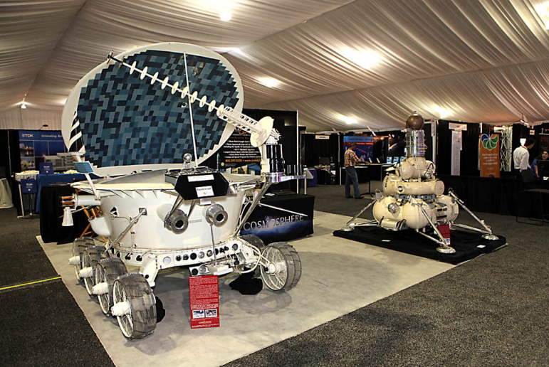
A Lunokhod Rover from the Kansas Cosmosphere and Space Center on display at the Space Symposium.
One of the major changes concerns the GPS IRT (Global Positioning System Independent Review Team), which John Darrah and I co-founded in the Chief Scientist Office at HQ Air Force Space Command just over 19 years ago in May. We decided that in order to operate totally independently, the IRT needed to be administered by a truly autonomous organization, so the IRT was designated to be tasked by the commander of AFSPC. For a time, this was the Undersecretary of Defense for Space through the auspices of an FFRDC (Federally Funded Research & Development Corporation) think tank, known as the Institute for Defense Analyses or IDA. During the last 19 years the IRT conducted studies and helped solve thorny space issues, mostly related to GPS and PNT, for eight commanders of Air Force Space Command and for key officials in the Department of Defense. Our first chairman was none other than the late Dr. James Schlesinger, who previously served as chairman of the Atomic Energy Commission, director of the CIA, U.S. Secretary of Defense, and the U.S. Secretary of Energy. He also served and advised eight presidents, and at the time of his passing was serving (since 2007) as the chairman of the National Space-based Positioning, Navigation, and Timing (PNT) Advisory Board. The PNT Board is composed of recognized GPS experts from outside the U.S. government that advise the deputy secretary level PNT Executive Committee in its oversight management of the GPS constellation and its governmental augmentations.
No sooner was the IRT formed under Dr. Schlesinger’s leadership than it was given a non-GPS or PNT-related task, and it proved to be a major task indeed. The task was to form a Broad Area Review panel for space launch and determine why the U.S. had, over the period of a few months, put more than $4 billion worth of space hardware into saltwater versus the vacuum of space. Since that original and subsequent BAR, the U.S. has not had a single complete launch failure in over 120+ launches, a record that cannot be claimed by any other space-faring nation and testament to the value of world-class, truly independent review teams that tell it like it is, warts and all.
Dr. Schlesinger represented the caliber of people that serve on the IRT, which still exist today as an independent panel led by Major General (USAF, Retired) Robert Rosenberg under the auspices of the Independent Strategic Assessment Group, also administered by IDA and chaired by former Chief of Staff of the USAF and former head of IDA, General Larry Welch (USAF, Ret).
The landscape and leadership are changing, but the National Security Space mission remains the same. Hopefully the national leadership will be able to adapt and perceive the current changes as opportunities – because while brilliant and intelligent leaders matter, people matter. Success should never be about personalities but rather about integrity, professionalism, and dedication – about doing the right thing and making the right decision every time.
What Is Don Reading?
This month I only have room for one important tome: Lindbergh by A. Scott Berg.
I initially read this wonderful volume several years ago and enjoyed it very much. I read it again recently because of the Time and Navigation display at the Smithsonian that piqued my interest in all things related to time and navigation through the ages. Lindbergh’s first solo flight across the Atlantic Ocean was not a flight of fancy, but rather a flight of daring as well as one of historical significance from a world-class aviator. He did not take any over-water navigation classes until after the event! As the jacket states, “…here at last is the definitive life of one of the most legendary, controversial, and enigmatic figures in American history.” I hope you enjoy it as much as I did. Highly recommended.
Until next time, happy navigating, and please make your plans now to attend the 31st Space Symposium in 2015. I hope to see you all in Orlando, Florida, at the ION JNC (Institute of Navigation Joint Navigation Conference) event later this month (June 16-19, 2014).
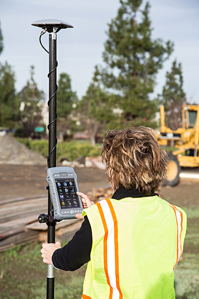
Sokkia has added the GHX2 network rover to its GNSS family of surveying products in the North American market. The GHX2 is designed to pair with the Sokkia SA300 external antenna to provide enhanced positioning accuracy and RTK performance in demanding environments.
“The power of a built-in survey and mapping grade GNSS receiver makes the GHX2 an excellent choice,” said Brice Walker, Sokkia vice president of survey sales. When combined with the Sokkia SA300 antenna, the system is a perfectly balanced and lightweight solution for surveying professionals.”
Features include a large 5.7-inch, sunlight readable touchscreen, waterproof housing, a built-in 3.2 MP camera with 4 GB of flash storage, and Bluetooth and Wi-Fi connectivity.
The system is compatible with MAGNET Field and Sokkia Receiver Utility (SRU) software.
Ethertronics has unveiled EtherHelix GPS, a small, stand-alone, Right Hand Circularly Polarized (RHCP) external GPS antenna. Measuring 35 mm in length, the EtherHelix GPS is 27 percent shorter than other antennas on the market with no performance trade-offs, the company said. It is designed for high-performance, mission-critical devices such as walkie-talkies, tough books, tough tablets, first responders, public safety, military applications and more.
EtherHelix can be tuned for various satcom frequencies and various polarizations (RHCP or LHCP). EtherHelix GPS is designed using Ethertronics’ patented Isolated Magnetic Dipole (IMD) technology providing high performance and efficiency in a small form factor.
EtherHelix GPS has a high tolerance to frequency shifts given the technology’s high RF isolation, which is designed to resist antenna detuning that can otherwise impair reception. EtherHelix GPS provides exceptional coverage inside buildings, vehicles or other areas where weak signals and signal reflection occur, the company said.
“GPS capabilities are critical for first responders and military applications. It is imperative that the antennas used in these devices are high-performance, small and rugged,” said Olivier Robin, general manager Americas and Europe at Ethertronics. “EtherHelix GPS is the most recent example of Ethertronics’ leadership in developing industry-first RF solutions to provide manufacturers with a way to differentiate their products and stand out in a competitive market. Already we have seen interest in our new EtherHelix GPS antenna given its best-in-class performance coupled with its smallest occupied volume.”
Given its reduced weight and size — 11.8 g and 35 mm long by 15 mm in diameter — manufacturers benefit from simpler integration for an array of GPS devices, Ethertronics said. In addition, the new GPS antenna’s capabilities include high selectivity, which minimizes the need for additional filters. EtherHelix GPS’s ruggedized design includes IP-68 protection from dust and water, as well as a standard SMA male connector for easy integration. The RoHS Compliant antenna is designed and manufactured in the United States.
EtherHelix GPS is commercially available now and is the first in a series of antennas for mission-critical applications.
The Leica Viva GNSS Unlimited Series, available in August, will allow customers to make a safe investment with future-proof GNSS receivers and smart antennas, Leica Geosystems said in announcing the new series. With a flexible design, the Viva GNSS sensors can be upgraded for maximum performance whenever needed.
The Leica Viva GNSS range fully supports the Chinese BeiDou navigation system. It can even provide BeiDou-only and GLONASS-only high-precision positioning. The unlimited series includes a future upgrade to a GNSS board with more than 500 channels and will serve users’ needs beyond 2020, the company said. Outages of real-time kinematic (RTK) communication links are bridged for up to 10 minutes with SmartLink to increase centimeter position availability in areas where RTK communications links are unstable.
Leica Viva GS15
The Leica Viva GNSS Unlimited Series can be upgraded to the full range of GNSS signals. The sensors’ future-proof design is equipped for GNSS modernization, providing users with confidence in their investment. The series embraces the future-proof concept by including an upgrade to a GNSS board with more than 500 channels. To fully guarantee future proof GNSS, board exchanges are inevitable because any likely modifications in GNSS signals require a new GNSS ASIC (Application Specific Integrated Circuit).
Leica SmartTrack technology guarantees accurate signal tracking, while SmartCheck technology evaluates and verifies RTK measurements to ensure reliable results. Both SmartTrack and SmartCheck technologies have been extended to support the BeiDou GNSS. BeiDou reached full operational regional capability in 2012 and has a total of 14 satellites. Leica Viva GNSS also supports features like BeiDou-only and GLONASS-only positioning to accommodate governmental regulations.
In addition, Leica Geosystems now offers SmartLink, a correction service delivered via satellite for uninterrupted centimeter positioning in areas where RTK communication links are unstable.
Leica Viva GS14
All Leica Viva GNSS products exceed the toughest environmental specifications, going beyond industrial standards such as IP68. This ensures flawless performance even in the most challenging environments. Applications for the range include construction and field surveying, mining, seismic work in dense forest, desert or mountains, as well as demanding work in extreme heat at 65°C (149 °F) or at extreme latitudes at -30°C (-22 °F). Premium precision and attention to detail ensure that the Leica Viva GNSS products can be trusted throughout the complete product lifetime.
Leica Viva offers a complete range of unlimited GNSS and TPS solutions made with Swiss precision, combining the highest accuracy with maximum versatility and optimized data flow. Leica Viva solutions include Active Customer Care (ACC) with an expansive organization of knowledgeable professionals to provide valuable support, training and service whenever needed. Combined with innovative services such as online support in the field with Leica Active Assist and an instant data exchange between field and office with Leica Exchange, Leica Viva enables continuous productivity.
Webinar on Multi-GNSS OEM
Thursday, June 5 10 a.m. PT / 1 p.m. ET / 5 p.m. GMT
GPS World’s upcoming webinar features an expert panel with informed viewpoints from GNSS high-precision and mass-market manufacturing, signal simulation, and alternative PNT providers. Registration is free.
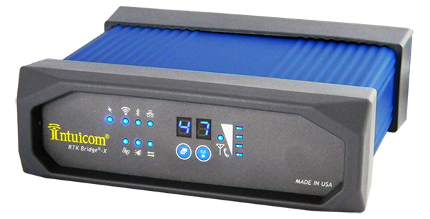
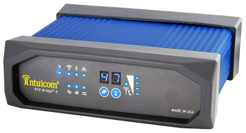
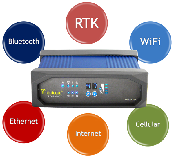
Intuicom, Inc., a wireless data solutions provider for the survey, machine control and precision agriculture industries, has added to its line of RTK Bridge solutions with the Intuicom RTK Bridge-X.
Along with providing reliable access to RTK corrections, the RTK Bridge-X features a Wi-Fi hotspot. Users can connect other Wi-Fi devices such as laptops, tablets and smartphones and access the Internet via the RTK Bridge-X’s cellular connection. Also new with the RTK Bridge-X is cable-free configuration. Configuration can now be accomplished through a wireless connection using any web browser.
Users can then access email, send files, and perform other Internet-based tasks using the connection provided by the RTK Bridge-X. With new Remote Access, the RTK Bridge-X can be reached over the Internet from anywhere.
The RTK Bridge-X also comes with internal GPS. Users can choose between an internal license-free 900-MHz radio, industry-standard UHF radio, or no radio.
Other improvements include a real-time cellular signal strength indicator on the re-designed front panel, as well as an Ethernet port that can be used for configuration or Internet connectivity. A numerical LED display now shows which of the four configurable profiles is active as well as which radio channel is selected. Bluetooth connections are also supported.
Like all Intuicom Bridge Products, The RTK Bridge-X is designed for easy setup and operation and is compatible with all major cellular carriers and equipment manufacturers including Leica Geosystems, Trimble, and others.
Trimble is offering a new agronomic service that is part of its Connected Farm solution. The new service, Soil Information System (SIS), provides farmers and their trusted advisors with in-depth 3-D soil data they can use to make more informed decisions about their crop production goals.
The SIS data is accessed through Connected Farm and can be used with Trimble’s Farm Works farm management software or other GIS platforms. Connected Farm enables better decision making by providing one central location for accessing key information impacting farm operations such as rainfall totals, weather forecasts, commodity tracking, planting coverage, yield mapping, fleet management, and irrigation monitoring and control, Trimble said.
The SIS 3D soil mapping technology uses advanced sensors along with intelligent targeting and geoprocessing algorithms to produce high-resolution, accurate soil and topographic information. By providing a greater understanding of the physical and chemical characterization of the soil, including how inputs move through the soil, SIS enables farmers to initiate more effective solutions to resolve the unique challenges of each area of their fields. The SIS solution outputs precise, multi-layer soil models that are more comprehensive than traditional methods used in the industry today. Some examples of map types include: root zone depth, soil texture, plant available water, compaction depth, macro and micro-nutrient levels, soil nutrient holding capacity, and salt and toxicity concentrations.
By analyzing soil variability and patterns prior to sampling — and by using its industry-exclusive data acquisition and analysis software — SIS provides targeted recommendations on the best locations where soil samples should be taken. In some cases this reduces the number of samples required to provide high-quality information by as much as 60 percent over traditional sampling methods. As a result, the solution enables agronomists to be more efficient with in-field data collection, providing valuable time and operating cost savings.
“By adding the Soil Information System solution to Connected Farm, Trimble is providing farmers and their agronomists with critical soil information they can use to improve crop production and benefit the bottom line,” said Levi Kettle, Connected Farm business area director of Trimble’s Agriculture Division. “For example, knowing the soil’s plant available water capacity can aid in irrigation layout, scheduling, moisture sensor targeting, root stock selection and many other management decisions.”
“Variability in yield and quality are due primarily to non-uniform soils being managed as uniform soils. In the past, our inability to identify the components of this soil variability prevented us from achieving greater crop uniformity and better economic returns,” said Robert Wample, Ph.D., a plant physiologist and owner of Edgeknoll Consulting, an SIS service provider. “SIS allows us to take a proactive approach to overcoming soil variability, and when combined with geo-referenced variability in crop yield and quality, the effectiveness of this approach is enhanced even more resulting in an ‘agricultural forensics’ approach to precision agriculture.”
The SIS solution is available in several service levels depending on the accuracy and resolution required for the particular crop type and the grower’s production goals.
Jack Dangermond, founder and president of Esri, has announced that Esri will make its advanced mapping software ArcGIS available for free to K-12 schools across the country, reports FORBES. Through the program, students will have access to the same cloud-based GIS technology used by governments and businesses to map and analyze data. The program is set to benefit more than 100,000 schools, with each ArcGIS online account worth about $10,000, adding up to a total potential value exceeding $1 billion, according to Esri.
“This is not a new endeavor by us. We have been supporting GIS in schools for more than 25 years,” Dangermond told FORBES. “Bringing GIS into schools gets the kids very excited and indirectly teaches them different components of STEM education. That’s been illustrated at school after school.”
The idea began when Dangermond met with President Obama a few months ago to discuss how Esri can contribute to the ConnectED Initiative, a program by the White House to help strengthen STEM education for K-12 students. “I asked myself: ‘What’s the biggest idea that we can go for?’” Dangermond recalled. As soon as he proposed that Esri would offer its software for free for every K-12 school in America, the president was immediately on board. “We thought this is a way to scale it up and bring GIS education to schools in the whole country,” Dangermond said.
Esri previously experimented with the initiative on a smaller scale in different states. In Detroit, students used the company’s software to identify environmental issues and come up with plans to fix them. Students also have used ArcGIS to map health issues in Los Angeles and use demographic data to get Walmart products delivered to returning veterans.
A new report from Research and Markets Ltd. forecasts intelligent transport systems, with a focus on highways. The report is titled “Intelligent Transport Systems Market by Component, Application, System (ATMS, ATIS, ITS- Enabled Transportation, Pricing System, APTS and CVO), and Geography (Americas, Europe, APAC, ROW) Analysis and Forecast to 2014-2020.”
Countries around the globe have started to employ a new set of technologies and approaches to meet the challenges that are surfacing in transportation. The applications of the Intelligent Transport System (ITS) are cater to today’s traffic challenges. ITS improves operational benefits of the transportation system by reducing delays, which develops the roadside infrastructure and allows the traffic to flow smoothly, the report says.
In developed countries such as the U.S., Germany, and France, ITS are already installed on a large number of highways. In developing countries such as India, China, Indonesia, the installation of ITS is increasing.
The ITS market covered in the report includes only the roadway transportation, as the rate of developments and improvements in the sector of roadway transportation is high. This ITS market research report covers Advanced Traveler Information System, Advanced Traffic Management System, ITS-Enabled Transportation Pricing System, Advanced Public Transportation System, and Commercial Vehicle Operation.
It also covers applications, including: fleet management and asset monitoring, traffic monitoring, collision avoidance system, traffic signal control system, variable traffic message signs, parking availability system, and traffic enforcement cameras. It also covers these components: PCB, Sensors, Surveillance Camera, Software License, Communication Networks, Monitoring and Detection System. Geographically, the report is segmented into North America, Europe, Asia-Pacific, and Rest of the World. These segments are further segmented into the major countries.
The report forecasts the growth from 2014 to 2020, along with market size, list of leading players, and the latest technology adopted M&A’s, and JV’s of key players.
Intelligent transportation market statistics with detailed classifications – market size, forecasts, and industry roadmap of ITS market, impact analysis of the market dynamics with factors currently driving and restraining the growth of the ITS market, along with their impact in the short, medium, and long term landscapes and Porter’s analysis of the market.
Key burning issues and opportunities with respect to ITS market.
Analysis of various ITS components, systems and applications of the market.
Identification of segments with high growth potential and key trends shaping and influencing the market.
Extensive segmentation, analysis, and forecast of the major geographical markets to give an overall view of the market – growth rates and trends of markets in the major revenue contributing countries such as the U.S., the UK, Germany, China, India, and Japan.
Competitive intelligence from the company profiles, developments, upcoming trends and technologies, revenue-growth strategies, and industry activities.
The governments of developing countries like Thailand, India, China, Malaysia, and so on, are revamping their infrastructures to develop road transportation.
Leica Geosystems has introduced its next generation vehicle-independent mobile mapping platform, the Pegasus:Two. By calibrating imagery and LiDAR point cloud data, the Pegasus:Two delivers highly accurate and economical geospatial data in a 360° spherical view while providing two methods for extracting data — either through LiDAR or via photogrammetry.
With its enhanced sensor platform using six horizontal cameras, plus an optional rear camera and a skyward view camera, a single high-speed LiDAR sensor, and an external output for an additional sensor, the Pegasus:Two enables unlimited mobile mapping applications, from pavement analysis to geo-referencing railways systems, now possible within the same platform, the company said.
From hardware to post-processing, Pegasus:Two allows economic data collection by balancing the largest pixel to sensor ratio on the market (5.5 x 5.5 µm), delivering extremely high image resolution, in a 4-MB camera and using a single low-noise, high-speed profiler. Users can download data via Wi-Fi or wired Ethernet, or even faster by using the latest USB3 interface, by means of a multi-core, industrial PC with 1-TB storage and a solid state drive, enabling longer missions. An optional rotation mount, designed specifically for the Leica ScanStation P20, also makes mounting the terrestrial scanner upside down or right side up while also enabling left or right rotation.
The Pegasus:Two in its new streamlined housing with aerodynamic design.
Expanding on the success of Leica Geosystems’ mobile mapping software, the latest software now offers semi-automatic object extraction features, which enable easy-to-use two-click GIS metadata extraction or calculation of distances on-the-fly directly into ArcGIS for Desktop software.
Leica Geosystems also introduces an external timing output and trigger signal for use with a variety of additional sensors, from a thermal camera, to ground penetrating radar, sonar, or even a pollution monitor. The External Trigger feature synchronizes time stamping and coordinates user data with one simple click, making 3D mobile mapping very user-friendly.
Urban canyons. Equipped with the NovAtel’s ProPak6 high-precision receiver for the most demanding city or rugged environments, the Pegasus:Two offers users a truly global system. It is a future-proof investment that tracks signals of all available constellations, GPS, GLONASS, Galileo and BeiDou as well as L-band, SBAS, and QZSS band coverage to ensure the best signal even when moving through urban canyons. The system provides a low noise, 200hz Inertial Measurement Unit for tracking the vehicle path thereby ensuring data is positioned accurately.
Aerodynamic design. The Leica Pegasus:Two mobile mapping system now comes with a new streamlined and compact look and continues to fit in only two travel cases. A convenient handle surrounding the unit enables easy mounting on and off your vehicles. The Pegasus:Two is a vehicle-independent system with a rechargeable 11 hour battery, and can be used on any moving platform.
“The Leica Pegasus:Two platform is a unique complete solution,” said Stuart Woods, vice president for Leica Geosystems Geospatial Division. “By providing software and hardware designed to seamlessly work together, users not only receive the latest in mobile mapping technology but also optimal performance and faster workflows. By keeping the platform vehicle independent and adding new sensor options, we encourage our customers to find new ways, to try out different sensors, new revenue models, and new places to measure. ”
Along with the Pegasus:Two, the advanced prototype, Pegasus:T2, a trolley based mobile system weighing less than 20 kilograms will also be on display at the HxGN LIVE 2014 Conference in Las Vegas.
Hexagon AB, a global provider of design, measurement and visualization technologies, has acquired iLab Sistemas, a provider of planning and optimization solutions for the agro business sector, with special focus in the sugar and ethanol industries. iLab will, together with Arvus and Leica Agriculture, form the backbone of Hexagon’s Smart Agriculture Solution.
Headquartered in Ribeirão Preto, Brazil, iLab takes advantage of extensive know-how and various techniques to deploy highly parameterized solutions that address complex problems related to agricultural processes and production. They include linear programming, operations research, genetic algorithms, constraint-based programming, neural networks, statistics and advanced mathematics. ILab’s offerings include software optimization tools for every stage of crop growth — from planting, harvesting and logistics planning to area and asset management, scenario comparisons, and cost and budget forecasting — permitting value-added decision analysis and process automation.
“Together with its established software suite of end-to-end planning optimization solutions for sugarcane mills, iLab’s strong market footprint in the sugarcane industry will support the further development of the Smart Agriculture solution from Hexagon Solutions,” said Hexagon President and CEO Ola Rollén. “Additionally, iLab’s offerings complement the product portfolios of Hexagon brands Leica Geosystems, Sisgraph and Devex in areas such as fleet management, precision agriculture, automation platforms and control room technologies.”
ILab will be fully consolidated as of today. The acquisition has no significant impact on Hexagon’s earnings, Hexagon AB said.