AT&T’s Network Disaster Recovery (NDR) program, as the first private company certified by the Department of Homeland Security for private-company voluntary disaster preparedness, is committed to maintaining and restoring the AT&T global network when natural disasters strike, the company said.
Despite predictions, no one is certain when the next tropical storm or hurricane will ravage the coastline. With $600 million invested in the NDR program, AT&T’s arsenal of equipment includes more than 320 technology and equipment trailers that can be quickly deployed, making it one of the nation’s largest and most advanced disaster programs.
“Staying connected during severe weather events is critically important to consumers, businesses and our emergency management officials,” said Sonia Perez, president, AT&T Louisiana. “That’s why AT&T invests a tremendous amount of resources in our network reliability and disaster response capabilities.”
The Network Disaster Recovery team works closely with other AT&T response teams, local AT&T network personnel, regional Emergency Operations Centers and Local Response Centers to fortify network facilities and equipment, and stage technicians and resources near the storm impact area. In the event of damage, teams are poised to restore and maintain service until permanent repairs can be made.
AT&T also conducts readiness drills and simulations throughout the year to ensure its networks are prepared and its personnel are ready to respond at a moment’s notice. Since its inception in 1991, the NDR has responded to more than 20 catastrophes across the U.S.
Response equipment readied in the wake of an event includes:
Mobile cell sites and mobile command centers
Emergency communications vehicles
A self-sufficient base camp, complete with sleeping tents, bathrooms, kitchen, laundry facilities, on-site nurse and meals ready to eat (MREs)
Hazmat equipment and supplies
Technology and support trailers to provide infrastructure support and mobile heating ventilation and air conditioning
Internal and external resources for initial assessment and recovery efforts.
Consumers and businesses also should have a plan in place. When preparing for an evacuation or shelter-in-place, remember these tips:
Keep your wireless phone batteries charged at all times. In case of a power outage, have alternate means of charging your phone available, such as an extra battery, car charger or device-charging accessory. Sales tax holidays are a great time to stock up on cell phone accessories for your household.
Keep your wireless phone dry. The biggest threat to your device during a hurricane is water, so keep your equipment safe from the elements by storing it in a baggie or some other type of protective covering, such as an Otterbox phone cover.
Have a family communication plan in place. Designate someone out of the area as a central contact, and make certain that all family members know who to contact if they get separated. Most importantly, practice your emergency plan in advance.
Forward your home number to your wireless number in the event of an evacuation. Because call forwarding is based out of the telephone central office, you will get incoming calls from your landline phone even if your local telephone service is disrupted at your home. In the unlikely event that the central office is not operational, services such as Voicemail, Call Forwarding, Remote Access call forwarding and call forwarding busy line/don’t answer may be useful.
Track the storm and access weather information on your wireless device. Many homes lose power during severe weather. If you have a working wireless device that provides access to the Internet, you can watch weather reports through services like AT&T U-verse Live TV or keep updated with local radar and severe weather alerts through My-Cast Weather, if you subscribe to those services.
Take advantage of location-based mapping technology. Services such as AT&T Navigator and AT&T FamilyMap can help you seek evacuation routes or avoid traffic congestion from downed trees or power lines, as well as track a family member’s wireless device in case you get separated.
Keeping the lines open for emergencies
During evacuations, the storm event and its aftermath, network resources will be taxed. To help ensure that emergency personnel have open lines, keep these tips in mind:
Text messaging. During an emergency situation, text messages may go through more quickly than voice calls because they require fewer network resources. All of AT&T’s wireless devices are text messaging capable. Depending on your text or data plan, additional charges may apply.
Be prepared for high call volume. During an emergency, many people are trying to use their phones at the same time. The increased calling volume may create network congestion, leading to “fast busy” signals on your wireless phone or a slow dial tone on your landline phone. If this happens, hang up, wait several seconds and then try the call again. This allows your original call data to clear the network before you try again.
Keep non-emergency calls to a minimum, and limit your calls to the most important ones. If there is severe weather, chances are many people will be attempting to place calls to loved ones, friends and business associates.
Small Business Tips:
Set up a call-forwarding service to a predetermined backup location. Set up a single or multiple hotline number(s) for employees, employees’ families, customers and partners, as appropriate, to call so that all parties know about the business situation and emergency plan.
Back up data to the Cloud. Routinely back up files to an off-site location. Services such as Mobile Workplace are a suggested solution for small businesses.
Outline detailed plans for evacuation and shelter-in-place plans. Practice these plans (employee training, etc.). Establish a backup location for your business and meeting place for all employees.
Assemble a crisis-management team and coordinate efforts with neighboring businesses and building management. Be aware that disasters affecting your suppliers also affect your business. Outline a plan for supply chain continuity for business essentials.
Consider a back-up cellular network. Services like AT&T Remote Mobility Zone, allows organizations to protect their critical communications by installing small cell sites at the businesses’ locations. If a disaster disables primary communications networks, the back-up cellular network can help keep your company connected.
In 2013, Lehmann Aviation launched the LA300 — a fully automatic personal drone working with Nokia Lumia 1020 and Windows 8 Tablet and designed for mapping and DEM.
Flight tests in May have proven compatibility of the GoPro Hero3+ camera, in addition to Nokia Lumia 1020 41-Mp camera, with the LA300 for orthomosaics and digital elevation models (DEM), which makes this drone the an affordable and easy-to-use professional rugged solution for mapping and surveying, Lehmann Aviation said.
LA300 is a fully automatic professional UAV designed for accurate mapping and surveying. To get the geo-referenced orthomosaics or DEM, the user needs to take three simple steps (watch the video below):
Step 1: Download the free Lehmann Aviation software — Operation Center — to any Windows 8 Tablet, Windows Phone 8, or PC. Step 2: Make the flight path by drawing on a touchscreen Windows 8 device the area of interest (on the map) and entering the waypoints, after which the software will automatically generate the mission. Step 3: Transmit the data to the drone by Wi-Fi, launch it by hand, and wait until the aerial robot returns to any chosen point with HD images or video on the SD card. Step 4: Use Operation Center to geotag each image after the flight, with LAT/LONG/ALT/YAW/PITCH/ROLL information.
The pictures then can be processed in any popular orthomosaic/DEM software to generate professional orthomosaics and 3D models.
The drone flies at a range of up to 15 km, at speeds of 20-80 km/h. It can be flown in harsh environments, between -25 °C up to +60 °C (-13 °F up to 140 °F), with winds up to 35 km/h (20kt). The LA300 weights 950 grams (including Nokia Lumia 1020 or GoPro Hero3+ camera), with a wingspan of 92 cm and the length of 45 cm. The drone is launched by hand and lands in a few meters of space.
All Lehmann Aviation drones come with one-year warranty and can be regularly upgraded to newer versions.
Tri-Band Multi-Constellation GNSS in Smartphones and Tablets
This article presents a single-chip BeiDou/Galileo/GLONASS/
GPS/QZSS/SBAS architecture for use in cell phones and tablets. The authors explain the advantages to end users of multiple constellations. They also examine the details of system interchangeability, multi-system issues, and how assisted-GNSS data operates with all constellations, including BeiDou.
By Frank van Diggelen and Kathy Tan
With GPS, GLONASS, SBAS, BeiDou, QZSS, and Galileo there are over eighty operational satellites. Why do we need all these satellites in the first place? The answer is simple: in urban environments we want a few (six to eight) good satellites with an unobstructed line-of-sight (LoS) to the receiver and good horizontal dilution of precision (HDOP). In order to achieve this, we need many more satellites in space than any single constellation. In this article, we address the following issues.
Receiver intersystem RF bias with a tri-band front-end. BeiDou uses a different RF section than GPS/Galileo/QZSS/SBAS and GLONASS. As a result, there is a receiver intersystem bias between BeiDou and each of these other systems—not just because BeiDou is on a different frequency, but because of the different RF path through the receiver. We explain how this bias is calibrated and removed.
In the space segment there are intersystem biases primarily caused by differences in time standards. We discuss time management and show how the different systems can be made interoperable.
BeiDou Assistance. In order to realize the benefits mentioned, we need infrastructure deployment for BeiDou assistance in accordance with 3GPP standards. We will discuss what is available, and what is left to do.
Coverage outside of China. Europeans can see more BeiDou satellites than Galileos. At the time of writing (March 2014) they could see approximately twice as many. Thus, when used in a multi-GNSS receiver, BeiDou is far from being just a regional system. We will provide coverage analysis, and live-test data, including a focus on Europe.
Finally, we will demonstrate all of the above in practice, explaining and showing how interchangeability is achieved, and where first fixes can be computed with no more than one of each satellite type.
Figure 1 illustrates the point referenced at the beginning, that we need many more satellites in space than any single constellation.
All of the lines in Figure 1 show signals that were actively tracked by the receiver at the position shown on the right. The orange lines are to satellites that are blocked, but the reflected signal is tracked. We do not want to use these measurements if we can help it, so we need many satellites to provide enough LoS signals.
Let’s look at the HDOP of the LoS signals. In this example, the HDOP for the three LoS GPS satellites was 50. For the three LoS GLONASS satellites, the HDOP was 45. However, with the combined GNSS constellation, the HDOP for the six LoS satellites was 2.2. In other words, we expect about a 20x accuracy improvement by using the combined constellation.
There are many places and times in cities where we see just one or two direct LoS signals from a particular constellation, and we need more than just GPS and GLONASS to get the desired number of good signals, thus explaining the desire and need for all available constellations.
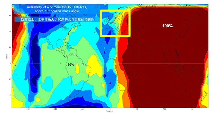
We’ll now look at the coverage provided by BeiDou2, which has five Geostationary satellites (GEOs), five inclined Geosynchronous satellites (GSOs), and four Medium Earth Orbit satellites (MEOs). With this 14-satellite constellation, the global coverage is as shown in Figure 2. This figure shows the percentage of time in a day that four or more BeiDou satellites are visible above a 10-degree mask angle. In the Asia-Pacific region, where the GEOs and GSOs are positioned, the coverage is predictably 100 percent. In fact, there are seven or eight BeiDou satellites visible in much of this region most of the time.
Figure 2. BeiDou2 global coverage.
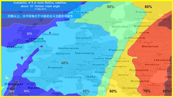
As shown in Figure 3, outside the Asia-Pacific region the coverage is also interesting. We see that at least four BeiDou satellites are available over Europe about half of the time. This is quite significant given the previous discussion; even one or two extra satellites can make all the difference in an urban environment. Another notable fact is that, for now at least, Europe can see more BeiDou than Galileo satellites.
Figure 3. BeiDou coverage over Europe. The different colors show the percent of time that four or more BeiDou satellites are visible above a 10° mask angle.
Technical Requirements
There are five significant technical requirements that we want to satisfy when creating a multi-GNSS receiver for consumer applications:
Three Separate RF Paths. To acquire and track all of the satellites already mentioned, we need three separate RF paths. Details follow in Section 3 (Front-End Architecture).
Search and Track capability for all visible GNSS satellites. The receiver must have the ability to search a very large number of code-frequency bins at once.
Host-Based. As much as possible, we want to make use of the host application processor (AP) and memory. This allows for tight integration with assistance data (which is coming from the host), other sensors, and other wireless data (such as Wi-Fi and Bluetooth for indoor locations). A host-based architecture also keeps size and cost as low as possible.
With Host-Offload. A significant trend in location applications is the need for “always-on low power” location. The host AP cannot be used for continuous position updates, since it draws too much power. So, while we want host-based location when the host AP is active (such as when navigating with turn-by-turn directions and a map), we also want a host-offload capability so that the GNSS chip can compute positions internally while the host is asleep.
Interchangeability. The ultimate requirement for multi-system GNSS is the ability to use any combinations of satellites as if they were all in the same constellation. This is summarized as “any four satellites will do.”
Front-End Architecture
From a cell phone/tablet perspective, the signals in space are all in the L1 band, with frequencies as shown in Figure 4. The key architecture feature of the GNSS front-end is that it should have three separate RF chains for the three separate frequencies-of-interest; see Figure 5.
Figure 4. Frequencies-of-interest for GNSS in cell phones.Figure 5. Front-end architecture showing three RF chains.
Baseband Architecture
The preferred architecture of a chip, as shown in Figure 6, is host-based to take advantage of the large host CPU when it is active. When the host CPU is asleep, a small, low-power, on-chip CPU is leveraged for background “always on” location. This enables applications such as geofencing to run without significantly reducing battery life.
Figure 6. Block diagram of the preferred architecture, showing a host-based configuration that includes a host-offload capability for geofencing and position caching on-chip when the host is asleep.
When the host is active, such as when you are actively using the phone for turn-by-turn navigation, the host AP is on and we want to make as much use as possible of the host AP and memory. This allows for tight integration with assistance data coming from the host, other sensors, and other wireless data (such as Wi-Fi and Bluetooth for indoor locations). A host-based architecture also keeps size and cost as low as possible, even with host-offload capability, which adds very little to the size of the chip.
Receiver Intersystem RF Biases
With the three different bands of frequencies, we will get RF group delays in the receiver front-end. These must be calibrated out by the receiver’s designer as part of the chip’s system design. If the group delay between BeiDou and GPS is not calibrated, it will lead to approximately three meters of bias between the two systems (Figure 7). Once it is calibrated, there is essentially no bias.
Figure 7. L1 frequency spectrum for BeiDou2, GPS, Galileo, QZSS, SBAS, and GLONASS.
Satellite Intersystem Biases
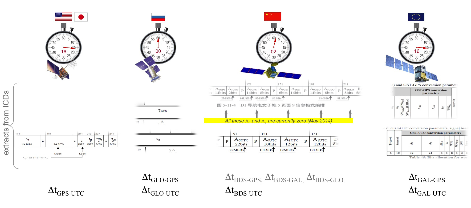
Different GNSS constellations run off their own master clocks; referenced to different realizations of UTC. GPS is referenced to UTC (USNO), QZSS is referenced to UTC (NICT), GLONASS to UTC (SU), BeiDou to UTC (NTSC), and Galileo to UTC (INRIM). GLONASS UTC (SU) differs from the others by 3 hours.
Furthermore, different systems treat leap seconds differently. This is indicated by the red arrows in the clocks in FIGURE 8. GPS, QZSS, BeiDou and Galileo system times are continuous and ignore leap seconds. Thus, each system time is ahead of UTC by a number of leap seconds. GPS time started in 1980 in synch with UTC; there have been 16 leap seconds since, so now GPS is 16 seconds ahead of UTC. QZSS and Galileo system times were started in synch with GPS. BeiDou system time was started in 2006 in synch with UTC; there have been 2 leap seconds since, so now BeiDou is 2 seconds ahead of UTC. GLONASS system time, on the other hand, includes leap seconds.
Apart from this, each of the different realizations of UTC is within several nanoseconds of the others.
To combine measurements from these different systems and avoid any time-induced intersystem biases, we need to resolve the time offsets. Each system transmits the delta-time between its system time and the systems that preceded it, as listed in Figure 8. To combine the systems, we either need to decode these data messages or obtain the delta-time values from Assisted GNSS.
Figure 8. Intersystem time differences and broadcast delta-time values from each system.
Note, however, that in the BeiDou broadcast Nav message the intersystem time-offset data values are all set to zero (even though the true offsets are not zero).
Assisted-GNSS Including BeiDou
Assisted GNSS, or A-GNSS, increases sensitivity and decreases the time-to-first-fix of a receiver by providing assistance data in the form of the receiver’s approximate position, time and frequency, as well as all data that the receiver might decode from the broadcast signals. The assistance data may also include data beyond what is broadcast, in particular, let’s focus on BeiDou time offsets. The BeiDou time offset to the other systems is included in the BeiDou broadcast Nav message as shown in Figure 8; however, at present these data values are all set to zero (even though the true offsets are not zero). Thus, in order to get these offsets and integrate BeiDou properly into a combined GNSS system, one must compute the offsets at a reference station and provide them as part of the assistance data, as shown in Figure 9.
Figure 9. A-GNSS provides broadcast satellite data over some other wireless network, as well as time-offsets between the different pairs of systems.
Commercial Implementation
The preferred architecture described in this article has been implemented in a commercial GNSS receiver that is now available for commercial host-based products, such as cell phones and tablets. The chip, Broadcom’s BCM47531, is the first consumer GNSS chip with a tri-band front-end capable of acquiring and tracking satellites from GPS, SBAS, QZSS, GLONASS, and BeiDou constellations, simultaneously; and operating in host-based mode for navigation and in host-offload mode for Always-On location.
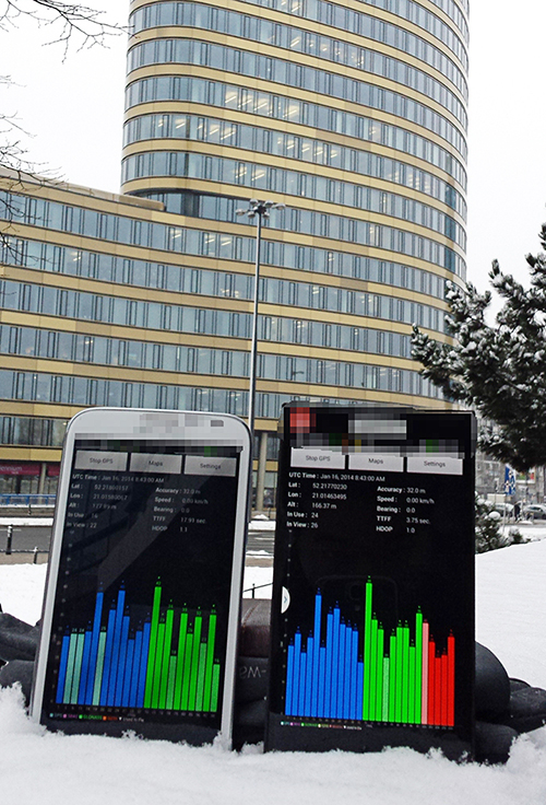
Broadcom has collaborated with leading smartphone manufacturers to launch the first wave of BeiDou enhanced consumer smartphones. Figure 10 shows one of these smartphones being tested in Europe. Note the number of BeiDou satellites in view. As predicted by the availability plots shown earlier, there are many BeiDou satellites in view (in this case, six).
Figure 10. GPS/GLONASS phone and GPS/GLONASS/BeiDou phone being tested in Warsaw, Poland. Note the six BeiDou satellites (red) that are seen and tracked by the BeiDou phone.
Interchangeability: Any Four
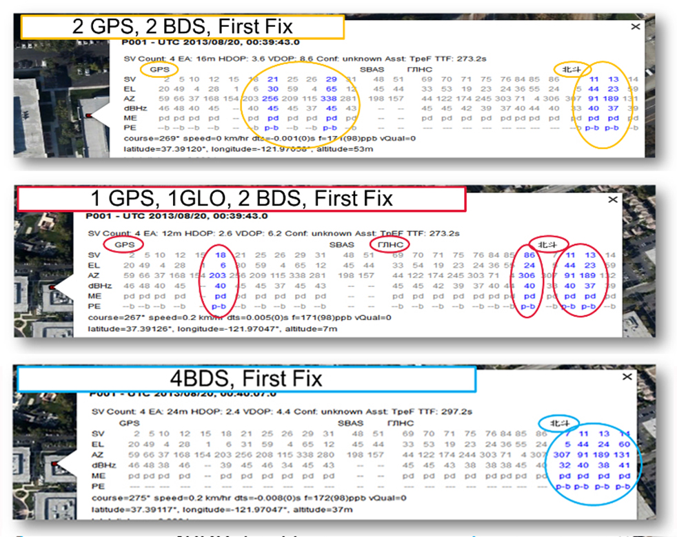
Now that we have addressed all of the major issues related to integrating different GNSS systems (in particular BeiDou), we can demonstrate the payoff.This is the achievement of interchangeability, where any GNSS satellites can be used together, as if they all belong to a single constellation. Figures 11 and 12 show assisted cold starts, where first fixes are obtained with no prior knowledge other than that provided by A-GNSS data. In each case, we show a different combination of satellites; including one satellite from each of four different constellations, and all four from BeiDou.
Figure 11. Interchangeability: Position fix with 1 GPS satellite, 1 GLONASS, 1 QZSS, and 1 BeiDou. The receiver is in Perth, Australia, where all of these constellations can be seen.Figure 12. Interchangeability: Assisted cold start, first fixes. Blue numbers show the satellites used in the position fix (top: two GPS and two BeiDou; middle: one GPS, one GLONASS, and two BeiDou; and bottom: four BeiDou only). The receiver is in San Jose, California, where four BeiDou satellites can be seen some of the time (some of the BeiDou GSOs can be seen and all the BeiDou MEOs can be seen for a few hours each day).
Multi-Constellation Robustness
While this article was being edited, the GLONASS system provided us with the most dramatic demonstration yet of the need for, and benefits of, multi-constellation receivers. On April 2, 2014, the GLONASS system failed spectacularly for a period of 11 hours. Receivers that used GPS and GLONASS had very large position errors, or no positions at all. While the receiver discussed in this article, the BCM47531, operated seamlessly. This receiver tracked GPS, GLONASS, QZSS and BeiDou satellites, correctly identified the faulty GLONASS satellites, and automatically stopped using them.
The details of the incident are as follows: The GLONASS control system uploaded incorrect orbit data to several satellites. When receivers used these satellites they had position errors of hundreds of meters, or no positions at all. At that time, the BCM47531 was being tested alongside a GPS/GLONASS receiver, and we have the data to show what happened. The receiver using only GPS/GLONASS suffered position errors of ten thousand meters, and long periods with no position at all; at the same time the multi-constellation receiver produced continual positions with normal accuracy. Figure 13 shows the test data — the left most image shows the route being driven, the middle image shows the data from the GPS/GLONASS receiver, and the right image shows the data from the BCM47531 multi-GNSS receiver. Figure 14 shows the details of the multi-GNSS receiver, you can see that no GLONASS satellites are being used.
FIGURE 13. Side-by-side tests of GPS/GLONASS receiver and multi-constellation receiver during the GLONASS incident of April 2, 2014. The GPS/GLONASS receiver produced errors of ten thousand meters and long periods with no position at all, while the multi-constellation BCM47531 operated seamlessly.FIGURE 14. Detail from the multi-constellation receiver when there is a problem with some satellites. The errors are recognized automatically by algorithms comparing the measurements to redundant measurements from the extra constellations, and the erroneous signals are not used.
This incident may raise the question: Why use GLONASS at all, why not just GPS? The answer is that in urban canyons, such as where this test was done, GPS alone does not have enough satellites to give the performance now expected in consumer products — for the reasons explained in the beginning of this article. Also, GPS, although it has been more reliable than GLONASS, is not immune to failures or jamming itself. The lesson of this incident is that reliability and accuracy comes from the combination of all the available constellations, with a receiver that can use the signals interchangeably.
Conclusion
We have shown the preferred architecture for a consumer GNSS receiver that includes all of the available constellations. We have addressed the major requirements of such a receiver for the consumer market, in particular, for cell phones and tablets. A receiver that meets these requirements is now available, the Broadcom BCM47531, has been designed into a new generation cell phones and tablets for 2014. Finally, we have shown how, with this receiver, the ultimate GNSS goal of interchangeability can be achieved.
Frank van Diggelen is vice president of technology at Broadcom Corporation, a consulting professor at Stanford University, and inventor of coarse-time GNSS navigation, co-inventor of Long Term Orbits for A-GNSS, and author of A-GPS: Assisted GPS, GNSS, and SBAS.
Kathy Tan is a senior principal engineer at Broadcom Corporation. She has worked on GNSS development and Assisted GNSS for Ashtech, Magellan, Global Locate and Broadcom. She received her MS and BS in electrical engineering from Fudan University, China.
Earth observing satellites are generating big data sets — Really Big!
I’m stepping in just for this month as a self-invited guest columnist, giving a brief look at the trailblazing work of the International Centre for Earth Simulation.
Look for both Eric Gakstatter and me at the ESRI User Conference in July, where Eric will also host a webinar on the hottest trends in mapping. We hope to accommodate a live audience at the webinar. If you’re not attending ESRI, attend the webinar anyway! For a top-level look at conference doings, register free.
In easily the most mind-blowing presentation of the Geospatial World Forum held recently in Geneva, Bob Bishop of the International Centre for Earth Simulation spun a vision of Big Data Earth Science, using the world’s largest computing resources (talk of exoflops and exobytes and “the human mind cannot comprehend these large volumes of data” supplied by many orbiting imagery satellites and other sensor inputs) to model the Whole Earth: surface, subsurface, ocean, atmosphere, and social economics.
The Centre’s mission is “Helping guide the successful transformation of human society in an era of rapid climate change and frequent natural disasters.”
In its prospectus, Bishop writes “The key to solving problems in weather, climate and environmental science is high-performance computing. Nature can only be accurately described and computed from equations that take account of complex, non-linear interactions between multiple natural systems, i.e. rivers, lakes, oceans, mountains, forests, dust, pollution, cloud cover, snow cover, ice, polar regions, etc. Such equations of motion are so interconnected and intertwined that they can only be managed when all aspects are held in big memory and computed simultaneously. Only then can we begin to address the systemic risks associated with natural disasters and planetary change.”
The ICES Foundation supports Open Science, which incorporates a combination of open data files, open source code, and open access publications. Much of the data supplied by the following organizations, upon whose resources ICES draws, is either directly produced by or referenced to GPS/GNSS data: Global Observing Systems Information Center and the U.S. National Oceanic and Atmospheric Adminisration; the European Space Agency and Centre for Space Records; the U.S. Geological Survey; the U.S. National Aeronautics and Space Administration; the European Union’s Joint Research Center; the U.S. National Center for Atmospheric Research; the U.S. Naval Research Laboratory; the European Commission’s Infrastructure for Spatial Information in the European Community (INSPIRE); and many more.
Slides from Bishop’s Geneva presentation are available here. These, however, of necessity lack some of the video and Flash Player simulations that he showed at the conference, revealing truly a dynamic planet in all aspects.
Bishop warned of both sequential and synchronous collapse of natural systems, leading to cascading crises. His language and message bear some resemblance to Al Gore’s An Inconvenient Truth, but Bishop, whose previous 40-year professional career had him responsible for building and operating the international aspects of Silicon Graphics Inc., Apollo Computer Inc., and Digital Equipment Corporation, has assembled some actual practical tools to apply to the many problems.
The immediate goal is modeling, simulation, visualization, and ultimately understanding of the whole, leading to new forms of civic engagement and insights as to risk, safety, food, water, and energy.
The highest court in the European Union has granted the right to be forgotten by a search engine. Will location privacy be next on the docket? We are seeing the beginnings of the in-car smartphone-type apps market and are watching for approaching hockey-stick style growth that is a year or two away. Google has added rich, engaging features to maps. And we take a look at results from indoor location advertising. Read more.
The European Court (EU) of Justice, made a curious and powerful ruling on privacy. The court stated that upon request, Google is obliged to remove reputation-hurting information that is generated by searching a person’s name. Like Mr. González, who brought this case to court, many of us have things in our distant past that we don’t want to be aired each time we are Googled. Perhaps it is an old bankruptcy or a youthful prank gone bad. The continuous re-airing of this information can make it hard for people to move forward in their lives. But while the court rule serves a purpose, it is poorly conceived and vague. The administrative complexity for search engines to comply is staggeringly onerous. And the information that it seeks to shield will still reside in websites.
How does this relate to location privacy? The EU Court of Justice is in the mood for privacy restrictions, and the use and handling of location data may be in their scopes. Also, sensitive location information can turn up in Google searches. A person in the EU will be able to request to have it shielded. Location information can be revealing. There may be records of check-ins from the café outside a rehab center or other treatment center, for instance.
Market, Fast Approaching. Companies are falling over each other for a piece of a new market about to burst open — software apps within vehicles. Analysts at IHS Automotive expect there will be 370 million smartphone apps for cars in use by 2020, a hefty growth from the 6.9 million units projected by the end of this year. Aha Radio is in Honda cars. General Motors is embedding Pandora, the music streaming app. 4G Internet connectivity will be in some GM and Audi models next year. BMW is opening app stores, this year in Europe and next year in the U.S.
The Players. Google and Apple (Google Projected Mode and Apple CarPlay) are poised to together dominate the market for auto apps integration, but other companies are in pursuit as well, including MirrorLink, Aha by Harman, and Ford Sync AppLink. North America is ahead of the global rush. Let’s hope some money flows into Detroit.
Google v. Apple. Information about Googles’ Projected Mode is scarce. Daimler posted an ad for a software engineer to help implement Google’s new in-car system, referred to as “Google Projected Mode.” The employment ad described Project Mode as a way to “seamlessly integrate” Android smartphones into a dashboard’s head unit. There is no mystery about Apple’s CarPlay, an extension of IOS. CarPlay simplifies the in-car experience by offering the same look and feel as an iPhone.
GM Pulls Ahead. Ford was the early automotive leader to offer smartphone-type apps with its Sync system, but more recent versions of the offering have had issues. They weren’t alone. Other car makers have had confusing interfaces that often contained annoying bugs. IHS now predicts that vehicle OEM adoption and integration will be led by General Motors. “Apps for autos are growing rapidly and will have a profound impact on auto infotainment and connectivity in the next decade,” said Egil Juliussen of IHS Automotive. “Auto apps will influence the competitive landscape among auto manufacturers and will even change the brand market share between them. OEMs will have to keep up to remain competitive.”
Better Google Maps. Google’s navigation system will now offer less congested or otherwise quicker routes during navigation, a byproduct of Google’s purchase of Waze. In addition, the navigation system will now advise on the best traffic lane, replacing less precise directions such as “keep left at the fork.” Google has partnered with cab provider Uber to show how long it would take to get home via cab when searching for public transit or walking directions. Google maps also now enable users to save entire cities for offline use.
Indoor Location Pays? In order for retailers to adopt indoor location technology, there needs to be clear returns. “A body of information is now gathering that verifies the effectiveness of these technologies,” reports Dominque Bonte of ABI Research. “We can see how limited trials are showing increases of advertising local search click-through rates from 0.1 to 3.5 percent, indoor location applications increasing basket sizes 10 percent, and how smartphones are significantly changing the cross channel shopping habits of users.”
Not everyone is talking up the accuracy of indoor positioning. Arlington, Virginia-based Telecommunications Industry Association says the technology, which is seen as the one way location-based services providers will be able to capture consumer interest, is not ready. In other LBS news, AT&T has come out with data pricing for its connected vehicle initiatives.
In a recent FCC filing, the Telecommunications Industry Association said that indoor positioning technology is not sufficiently developed to support ongoing wireless E-911 location accuracy requirements.
While TIA supports the FCC’s goal to improve location accuracy, “Imposing location accuracy mandates at this time would be premature, given the nascent stage of the technology that will be needed to accomplish the Commission’s objectives, and should neither favor nor disfavor specific technologies,” said the association in its filing.
The NPRM proposes a requirement to achieve “rough” indoor location information, TIA said. It proposes to require providers to provide horizontal information for wireless 911 calls that originate indoors, specifically a caller’s location within 50 meters.
TIA also disagrees with an FCC proposal to require mobile operators to provide z-axis, which is vertical location within 3 meters of a caller’s location, for 67 percent and 80 percent of indoor wireless 911 calls — ranging from three to five years after adoption. Again, TIA says that the technology is not fully developed.
TIA quoted AT&T’s filing: “[The] time [is] right to begin discussing Indoor Location Accuracy for E-911” but the “FCC should be careful to ensure that any proposed rules on location accuracy are aligned with proven capabilities of the current state of technology and they should set realistic accuracy benchmarks that the industry and public safety can embrace.”
The location industry has been counting on indoor positioning, with its beacons and Wi-Fi enhancements, to jump-start a location-based services market that always seems to have tremendous potential, but the numbers don’t back it up. Some big-time analysts have said that while the promise of indoor positioning is huge, it just isn’t there technically yet.
In fact, one analyst said that the biggest technological breakthrough last year was indoor mapping. Such major retailers as Home Depot and Lowes launched indoor maps with product search locators. These same analysts say that indoor Wi-Fi positioning is not accurate enough for macro location.
The big deal coming up is how FCC positioning accuracy regulations will affect beacons or Bluetooth low energy for micro location and proximity services.
TIA said it supports initial FCC location accuracy requirements back to 2007. However, don’t ask TIA for more location regulation. “To date, the development of 911 and E911 location accuracy technologies and applications has been fostered by a voluntary and consensus-based standards process. This process has proven quite successful to date, and the Commission should refrain from imposing regulations that could slow additional development,” the association said.
AT&T Announces Connected Car Pricing
AT&T Mobility said standalone pricing for new LTE-enabled OnStar service will be $5 or $10 per month, depending on whether the driver is an OnStar subscriber. The company said it will allow customers, with a GM LTE-capable vehicle, to add the car as another device for $10 — which is the same price as a tablet.
OnStar subscribers will get coverage ranging from $5 for 200 MB of data per month to $50 for 5 GB. GM is also allowing customers to buy one-time data packages.
At this year’s CES, General Motors announced its first LTE-enabled vehicles — in which AT&T Mobility is powering the LTE network for GM’s OnStar service. The first LTE-enabled vehicles, which will be available this summer, are Impala, Spark, Volt, Orlando, Spark RV, Silverado, Silverado HD, Malibu, Equinox and Corvette Stingray. GM plans to have 30 Chevrolet, Buick, GMC and Cadillac vehicles LTE-equipped by the end of the year.
AT&T also made recent deals to provide connectivity for Ericsson Connected Vehicle Cloud which connects to the AT&T Drive platform for automakers.
CEA Hosts CES on the Hill
Members of Congress and their staff had the opportunity to observe location technology during the Consumer Electronics Association’s recent CES on the Hill event in Washington. Exhibiting companies include Origo Safe, distracted driving; AT&T Drive; DashIt; Qualcomm, which showed off a geofencing product around schools; and RideScout.
Washington-based Ridescout is a cool, and free, mobile app that allows a user to find the nearest subway, bus, taxi, bikeshare, sedan service, carshare, pedi-cab or carpool. A user can choose from a list of options by proximity, cost or arrival time.
“We launched in November in Washington, D.C. We are in Austin, San Francisco, Boston, Chicago and planning several new markets,” said Steve Carroll, Ridescout vice president of operations.
The app, which is on the iOS and Android platforms, generates revenue by sharing with the ride providers, large organizations and universities and the public transport network, Carroll said.
Some of Ridescout’s partners include Mozio, RidePost, Metro of Washington, Bandwagon, Sidecar, Car2Go, Arlington Transit, Capital Bikeshare, Yellow Cab, DC Circulator and Dash.
RideScout, founded by two Army veterans, was hatched when founder and CEO Joseph Kopser wanted an application to show him the best way to get to work in the Washington area. He could not find one and started the company with Craig Cummings. The company initially launched an alpha product at South by Southwest in 2013.
Though it was the first to combine all modes of transportation in a single application, the company has some competition. Of course this competition is from the 800-pound location gorilla, Google.
Google, with its Google Maps platform, shows the directions to the nearest transportation mode. Now it is incorporating Uber, which is an on-demand transportation provider.
This is not the first time Google has launched a product in an effort to dominate a market place or niche. When it launched Google Maps in 2009, it put the hurt on many companies in the location industry, which underwent a three-year period of consolidation, company closings and layoffs.
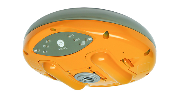
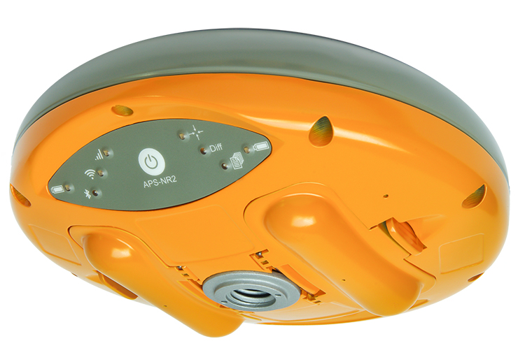
Altus Positioning Systems has introduced its new APS-NR2 RTK surveying receiver. The new product is being previewed at the 2014 Geo Business conference and exhibition in London May 28-29, and will be commercially available in July.
“The APS-NR2 provides a powerful combination of high GNSS RTK performance, light weight, low power consumption, versatile Quad-band modem, remote Web-based access and connectivity with Esri’s cloud-based platform,” said Neil Vancans, Altus president and CEO. “The result is a versatile product designed to enhance productivity and minimize downtime in the field for a wide range of surveying and geolocation jobs.”
The APS-NR2 is Altus’ second-generation RTK rover, building on the highly successful APS-3 product series. It features an easily accessible on-board web interface and integrated Wi-Fi for easy remote configuration and status monitoring, as well as Bluetooth for real-time data streaming, providing true cable-free operation. In parallel to RTK positioning, data can be recorded on a removable 2-GB SD memory card for post-processing.
The APS-NR2 is built around a low-power 132-channel GPS/GLONASS L1/L2/L2C SBAS receiver, which offers robust RTK performance, as well as DGPS capability. The internal 3.5G Quad-band GSM/GPRS/EDGE cellular modem supports RTK network connectivity. Dual internal cellular antennae ensure a positive signal lock and minimize disruptions due to dropped calls.
The new Altus receiver comes with two Li-Ion batteries. It has a built-in USB battery charger, as well as a separate two-bay external charger. The batteries are hot-swappable, allowing uninterrupted productivity on the job.
With Altus’ open-architecture philosophy, the user has a choice of data collector software from Carlson SurvCE, MicroSurvey FIELDGenius or direct interface to Esri ArcGIS Online, as well as proprietary customer-developed software.
The APS-NR2 doesn’t sacrifice essential processing power or connectivity and still weighs only 0.7 kg (1.5 lbs). The compact receiver is just 69 mm (2.7 in) high and 167 mm (6.6 in) in diameter. The rugged unit is waterproof to IP67 and has an operating temperature range of -40 to +85°C.
GPS World Publisher Steve Copley is attending GEO Business 2014, where GPS World is a sponsor. The show is being held in London this week. He’s been tweeting from the show. Follow his tweets here, and GPS World’s Twitter account here.
GEO Business 2014 is a new geospatial event for everyone involved in the gathering storing, processing and delivering of geospatial information. It is organized in collaboration with The Chartered Institution of Civil Engineering Surveyors (ICES), The Association for Geographic Information (AGI), The Royal Institution of Chartered Surveyors (RICS) and The Survey Association (TSA).
McMurdo Group, an end-to-end search and rescue (SAR) and maritime domain awareness (MDA) company, has acquired Techno-Sciences, Inc. (TSi), a provider of SAR satellite ground stations, integrated emergency response center systems and coastal surveillance solutions. Terms of the acquisition were not disclosed. TSi’s Beltsville, Maryland, location becomes the U.S. headquarters for McMurdo Group, a division of Orolia, global specialist in critical GNSS solutions.
TSi has been instrumental in the development of the COSPAS-SARSAT international satellite-based SAR program, which has helped to save more than 35,000 lives worldwide since 1982. TSi is also actively involved in the next-generation COSPAS-SARSAT system, MEOSAR (Medium Earth Orbit Search and Rescue), which will greatly improve the existing SAR process with near-instantaneous detection, identification and location of emergency distress beacons.
MEOSAR, currently in its demonstration and evaluation phase, is expected to have initial operational capability in 2016 and full operational capability by 2018. MEOSAR will use SAR-enhanced Galileo (Europe), GPS (U.S.) and GLONASS (Russia) satellite constellations for greater global coverage and includes innovative end-user beacon functionality such as a return-link service on Galileo satellites to acknowledge distress signal receipt and provide ongoing rescue effort status.
“The acquisition of TSi firmly establishes McMurdo Group as the global leader in satellite-based search and rescue solutions. We are the only provider capable of supplying a single-vendor, end-to-end COSPAS-SARSAT emergency solution with a seamless ecosystem of products, technologies and processes that will streamline and expedite search and rescue efforts,” said Jean-Yves Courtois, CEO, McMurdo Group and its holding company Orolia Group. “TSi expands our global sales, support and customer footprint and adds to our already extensive expertise in SAR and MDA. We look forward to developing a U.S. SAR Center of Excellence to include manufacturing, distribution and support of McMurdo Group’s broad solution offering of distress beacons, AIS equipment, satellite communications units and emergency control centers equipped with search and rescue management software.”
TSi solutions are installed in more than 20 countries worldwide and include satellite ground stations or local user terminals (LUTs), rescue and mission control centers, and coastal surveillance/instruction detection systems. TSi installed the world’s first operationally ready six-channel MEOSAR LUT (MEOLUT) in 2011 for the U.S. National Oceanic and Atmospheric Administration (NOAA) and has recently completed a second NOAA installation (March 2014). With a team of 40 employees, TSi has a prominent list of government, military and commercial customers in Asia, Europe, Africa and the U.S. (including NOAA, NASA and the U.S. Navy).
Port Douglas, Queensland, Australia, is looking to reduce any potential deaths from falling coconuts, reports ABC News.
The Douglas shire council is mapping the GPS locations of its coconut trees, to reduce the danger. Mayor Julia Leu says more than 4,000 mature coconut palms have been identified in Port Douglas.
“All local governments that have coconut palms in their area do have a de-nutting program. However the de-nutting process is very costly,” Leu said. “What we want to do is look at this in a far more innovative way.”
On average, 150 people die annually around the world from falling coconuts.
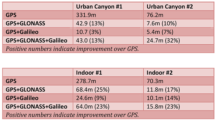
The European GNSS Agency (GSA) and Rx Networks Inc., a mobile location technology and services company, announced the results of tests conducted by the company measuring the performance of Galileo when used in various combinations with GPS and GLONASS.
Tests were conducted in real-world environments, including urban canyons and indoors. These environments pose significant challenges to location accuracy due to multipath and obstructed views of satellites. Each test consisted of a three-hour data capture of GNSS signals, which was later replayed to produce hundreds of fixes using a multi-constellation GNSS receiver from STMicroelectronics.
The results showed that using Galileo with one or more other GNSS constellations provides significantly more accurate location fixes compared to GPS alone, when indoors or in urban canyons. As expected, the GPS+Galileo combination did not exceed the performance of GPS+GLONASS, due primarily to there only being four Galileo satellites available at the time of the testing. It is expected that, as more Galileo satellites are launched, the combination of Galileo with GPS will show further improvements in performance, GSA and RX Networks said.
According to Gian-Gherado Calini, head of Market Development at the GSA, “Dual-constellation GNSS designs are the standard for many smartphones and other devices. The combination of GPS and Galileo provides a robust solution and is expected to offer performance that will meet or exceed end-user expectations.”
“The results should be encouraging to any GNSS chipset manufacturer who is considering adding Galileo as a competitive differentiator,” said Adrian Stimpson, senior vice president of Sales and Marketing, Rx Networks.
Test Results
Recent test results confirm that Galileo significantly improves accuracy in challenging environments:
The tables above show the summary results for various scenarios and constellation combinations. The GPS row shows the absolute 2D errors in meters. All other rows show the improvement (+) or degradation (-) in meters and percentages relative to GPS-only fixes. All measurements are within the 95th percentile.
Globecomm, a global provider of communications solutions and services, has received a contract extension from NATO Communications and Information Agency (NCI Agency) valued at $9.6 million to extend communication services and onsite support for the company’s previously deployed GPS-Based Force Tracking System (FTS).
The FTS provides NATO with high levels of tracking data and messaging traffic. It enables NATO to identify where its personnel are located at all times, identify other multinational forces, and have the ability to do so in routine and operational situations. This is critical in assisting with the identification of friendly forces and helps prevent “blue-on-blue” incidents, the company said.
Globecomm previously announced approximately $74.7 million in contracts from NATO for this project to design and install a GPS FTS, bringing the combined contract value to approximately $84 million.
“Globecomm is pleased to receive this contract extension to continue to deliver this important service,” said Paul Knudsen, vice president of Globecomm’s Eastern Atlantic Team. “We completed an upgrade of this system last year under a separate contract that was previously announced. Globecomm has been providing this service since 2007.”


 The drone flies at a range of up to 15 km, at speeds of 20-80 km/h. It can be flown in harsh environments, between -25 °C up to +60 °C (-13 °F up to 140 °F), with winds up to 35 km/h (20kt). The LA300 weights 950 grams (including Nokia Lumia 1020 or GoPro Hero3+ camera), with a wingspan of 92 cm and the length of 45 cm. The drone is launched by hand and lands in a few meters of space.