HX Global’s new Travel Oracle mobile app provides an instant lifeline for business travelers and expatriate employees as well as access to critical information and support, before and during their travels, the company said. Key features include an instantly accessible Mayday call, automated personal tracking, online storage of all travel documents, instant news reports of unrest pushed to impacted travelers, e-learning travel security certification and destination profiles.
“Duty of Care requires that measures be taken to protect employees and Travel Oracle accomplishes that,” said Gregory Cain, president of HX Global. “Emergencies can strike at any time. On average, we airlift six medical emergency cases every day and respond to more than 450,000 assistance calls every year. The Travel Oracle app provides a safety net for employees and employers to provide protection for security issues and medical emergencies.”
“Traveler tracking systems have provided travelers and corporations with peace of mind over the years, but they have significant limitations,” said Dave Sarafinas, managing director and senior vice president of HX Global. “Travel Oracle overcomes those limitations by making traveler tracking personal and proactive. This new tool helps corporations provide end-to-end travel security.”
Travel Oracle leverages eLearning, live personal tracking and situational awareness to drive traveler empowerment. Combined with HX Global’s global capabilities and resources in the event of an emergency, a Travel Oracle traveler will be safer, and employers have the confidence that they have exceeded duty of care responsibilities. Key features include:
Emergency Call Function – calls are instantly sent to a 24/7 Command Center
Mayday Alert-Personal Tracking – alerts nominated contacts of traveler whereabouts via email, takes situational photographs, sends an audio recording and current GPS location, if pre-authorized
Online Personal Profile & Documents – online storage of travel documents and photographs
News Alerts and Live Support – global incident monitoring service with real-time country alerts sent directly to employee mobile devices. Access to 24/7 Emergency Assistance Helpdesk
e-Learning – travel safety courses, including certification upon successful completion
Country Profiles – comprehensive country briefings on over 200 countries including country risks and cultural differences
On April 1, Rohde & Schwarz joined the M2M Alliance, the largest association for the machine-to-machine sector.
“The advanced networking between people and machines and among machines themselves is completely changing our lives. It is opening up entirely new fields of application for our wireless test solutions,” said Jörg Köpp, who is responsible for the M2M/NFC market segment at Rohde & Schwarz. “With our commitment to the M2M Alliance, we want to promote this future-oriented technology worldwide.”
“We are very pleased to welcome Rohde & Schwarz to the M2M Alliance and gain a wireless specialist that has stood for quality and innovation in wireless communications technology for 80 years,” said Eric Schneider, first chairman of the M2M Alliance. “The company’s wireless test solution expertise and comprehensive portfolio make it an asset to the entire M2M industry.”
The reliability and security of mobile and wireless technologies are crucial to the success and acceptance of M2M applications. There are many industries where wireless applications have not previously played a role, but now even household appliance manufacturers, for example, are facing the challenge of integrating wireless components into their products. They need to verify that these components function correctly and obtain any necessary certification.
Rohde & Schwarz supports these users by providing T&M equipment for almost all mobile, wireless and positioning technologies, from LTE/LTE-Advanced, UMTS/HSPA(+), CDMA2000, Bluetooth and WLAN wireless Internet access to GPS/Galileo. Rohde & Schwarz also offers specific test solutions for eCall and vehicle-to-vehicle communications. Solutions for secure M2M communications and monitoring of associated networks round out the portfolio.
GPSTrackIt now offers Vehicle Diagnostics through its Fleet Manager dashboard to give fleet operators information about a fleet’s health in real time. The information is the same as that used by professional mechanics to identify why a check engine light is on.
Since 1996, vehicles sold in the United States have been equipped with an On Board Diagnostics (OBDII) port. Mechanics plug a handheld computer into the port to read the codes produced by the on-board computer. GPSTrackIt offers two ways to gain the benefits of vehicle diagnostics — with its new CP3000V plug-and-play device or the L2000V adapter cable.
The vehicle diagnostic codes received are used to determine the health of the various systems (ABS, Airbags, etc.) throughout the entire vehicle. In addition to the engine codes themselves, the system reports on a variety of indicators and parameters related to the codes.
“A key feature is that this engine diagnostic data can be used to trigger SMS text or email alerts,” said Eddie Bermudez, GPSTrackIt’s Product Development Manager. “These alerts would be sent to designated personnel. Being able to identify problems early helps reduce and often times eliminate costly repairs.”
Friday’s launch of a Delta 4 rocket carrying the latest GPS satellite was tracked via GPS itself instead of by radar, reports Spaceflight Now in an article.
United Launch Alliance’s Atlas and Delta rockets are transitioning to GPS metric tracking for range safety functions, which protect the public and property should a launch vehicle veer off course. The move is a money-saving upgrade to the military’s aging range infrastructure.
A special avionics system on the launcher transmitted the location. For decades, most rockets launching from Cape Canaveral, Florida, and Vandenberg Air Force Base, California, have been tracked by C-band radar.
Many of the nation’s leading public safety and public health organizations submitted comments this week in support of a proposed Federal Communications Commission (FCC) rule to help emergency responders more quickly and accurately find 911 callers using wireless phones from indoor locations. More than 300 individuals and organizations filed during the initial comment period with the overwhelming majority supporting the FCC proposal.
Among those supporting the rule were many of the largest and most respected organizations representing 911 professionals, police officers, fire fighters, EMS workers, public safety professionals, older Americans, heart attack and Alzheimer’s patients, and the deaf and hard of hearing. They were joined by hundreds of individual 911 dispatchers and first responders who submitted personal comments through the FCC’s web site or in survey responses that were filed with the FCC.
“The support for this rule across the public safety and public communities is truly breathtaking,” said Jamie Barnett, director of the Find Me 911 Coalition and former chief of the FCC’s Public Safety and Homeland Security Bureau. “These organizations are on the front lines of emergency response, and they know that lives are being lost every day because 911 professionals cannot quickly find indoor callers using wireless phones. The urgency of this rulemaking is unquestionable, and we commend Chairman Wheeler and the other commissioners for their leadership by taking fast action on it.”
According to the FCC’s estimates, at least 10,000 lives a year could be saved by improvements in response time through the FCC’s proposed rule. All of the comments submitted are online.
Find Me 911 is an effort supported by more than 200,000 individuals, as well as national and local organizations. The individuals and organizations represent a broad range of 911 operators and first responders — emergency medical services personnel, fire fighters and police. Find Me 911 seeks to ensure that the FCC moves forward quickly to establish a reasonable, measurable level of location accuracy for emergency calls made indoors, enabling first responders to locate emergency calls from wireless phones from all locations rapidly and efficiently.
Among the organizations filing joint or individual comments in support of the FCC’s proposed rule were:
Law Enforcement
International Association of Chiefs of Police
National Sheriffs’ Association
Fire Fighters
International Association of Fire Fighters
International Association of Fire Chiefs
Emergency Medical Professionals
National Association of State Emergency Medical Services (EMS) Officials
National Association of EMS Physicians
National Association of EMTs
National EMS Management Association
American College of Emergency Physicians
9-1-1 Professionals
National Association of State 911 Administrators
National Emergency Number Association
Association of Public Safety Communications Officials
CALNENA
Texas 9-1-1 Alliance
Texas Commission on State Emergency Communications
[Texas] Municipal Emergency Communication Districts Association
San Francisco Department of Emergency Management
Nebraska Public Safety Commission
Older Americans
AARP
Alliance for Retired Americans
Public Health
Alzheimer’s Association
American Heart Association
Public Safety
National Association of Regulatory Utility Commissioners
National Public Safety Telecommunications Council
Deaf and Hard of Hearing
Telecommunications for the Deaf and Hard of Hearing
National Association of the Deaf
Association of Late-Deafened Adults
Cerebral Palsy and Deaf Organization
California Coalition of Agencies Serving the Deaf and Hard of Hearing
Deaf and Hard of Hearing Consumer Advocacy Network
Flawed processing of GPS satellite data in some GPS receiver chipsets has caused concern, but the problem is not with the GPS constellation itself. “SVN 64 broadcasts a data message that clearly indicates SVN 64 is unusable for navigation. Nevertheless, the U.S. government has confirmed that certain GPS receivers are using data from SVN 64, in violation of GPS interface specifications, resulting in outages or corrupted, inaccurate position calculations,” Executive Secretariat Rick Hamilton, Civil GPS Service Interface Committee (CGSIC), said in a May 15 message.
Read the full text of the message below.
Known Problem with Certain GPS Devices
May 15, 2014
Recently, many GPS users have reported intermittent GPS outages in their devices. After investigating, the U.S. government has linked the problem to flawed processing of GPS satellite data within certain GPS receiver chipsets. The GPS satellite service continues to function as designed and is fully operational and available worldwide.
The problem affects only user equipment that erroneously ignores the satellite health status information broadcast from every GPS satellite. The problem is not related to the April 28, 2014, activation of civil navigation messages on the GPS L2C and L5 signals.
Since March 15, 2014, the Air Force has been conducting functional checkout on a GPS satellite, designated Space Vehicle Number (SVN) 64. SVN 64 broadcasts a data message that clearly indicates SVN 64 is unusable for navigation. Nevertheless, the U.S. government has confirmed that certain GPS receivers are using data from SVN 64, in violation of GPS interface specifications, resulting in outages or corrupted, inaccurate position calculations.
The Air Force testing is scheduled to end in mid-May 2014 at which time SVN 64 will begin normal operation. At that point, these problems may stop occurring. Meanwhile, the U.S. government urges all GPS device makers to review their products for compliance with the GPS interface specifications, and if necessary, to issue software/firmware updates to users as soon as possible. View specifications.
Users experiencing GPS outages should check with their device manufacturers for available software/firmware updates. In addition, any civil user seeing unusual behavior in GPS user equipment should report it to the U.S. Coast Guard Navigation Center (NAVCEN). Aviation users should file reports consistent with FAA-approved procedures. Military users seeing unusual behavior should report it the GPS Operations Center (GPSOC).
Please direct any civil user questions to NAVCEN at (703) 313-5900,
http://www.navcen.uscg.gov
Please direct any military user questions to the GPSOC at (719)
567-2541, DSN: 560-2541, [email protected] https://gps.afspc.af.mil
Military alternate: Joint Space Operations Center, (805) 606-3514,
DSN: 276-3514, [email protected]
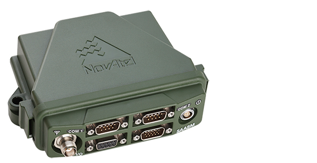
NovAtel has launched the FlexPak-S GNSS SAASM enclosure. The FlexPak-S contains a NovAtel dual-frequency OEM625S receiver card integrated with L-3’s XFACTOR Selective Availability Anti Spoofing Module (SAASM) onboard. The FlexPak-S is security-approved by the GPS Directorate for operational use.
NovAtel made the announcement at AUVSI’s Unmanned Systems 2014, being held this week in Orlando, Florida.
When keyed by authorized defense integrators, the FlexPak-S provides centimeter-level Real Time Kinematic (RTK) Precise Positioning Service (PPS) solution by taking the raw measurements from the XFACTOR SAASM and applying them to NovAtel’s Advanced RTK algorithms. The FlexPak-S can be handled as unclassified when keyed.
In the Standard Positioning Service (SPS) fallback mode, the FlexPak-S continues to provide centimeter-level accuracy by utilizing NovAtel’s dual-frequency civil GNSS positioning engine. FlexPak-S’ fallback mode is configurable for GPS or GPS+GLONASS. Adding GLONASS tracking increases position performance in obstructed sky conditions, which is a benefit for unmanned ground vehicles.
FlexPak-S was developed for size-constrained environments, so it’s compact and lightweight, NovAtel said. Despite its size, the rugged GNSS enclosure has been engineered to ensure reliability, even in harsh environments. The IP67 housing is water-resistant and operates in a wide temperature range. FlexPak-S also allows for easy integration with standardized hardware connections and NovAtel’s comprehensive set of software commands. The SAASM position is provided via a dedicated communication port, as well as through NovAtel’s software command protocol, allowing for maximum flexibility. FlexPak-S uses the same form factor as the FlexPak6 design.
“FlexPak-S is a great option for customers looking for a reliable solution in environments where size is critical, like UAV and robotics applications,” said Shane McEwen, product manager for NovAtel Enclosures. “With standard software and hardware connections, integration is simplified so there is a quicker time to market.”
Applanix Corp. and American Aerospace Advisors, Inc. (AAAI), have agreed on an OEM supply agreement that will incorporate Applanix direct georeferencing technology into AAAI’s unmanned aerial platforms. The collaboration creates a commercially available professional-grade mapping UAV system for civilian applications such as pipeline monitoring, power line surveys and emergency-response mapping.
The availability of the system follows a series of successful test flights of AAAI’s RS-16 Unmanned Aircraft System equipped with Applanix’ DMS-UAV aerial photogrammetry payload with commercially available inertial technology. Joint teams from Applanix and AAAI planned and flew a sequence of missions to evaluate the capabilities, including the ability to provide highly accurate, directly georeferenced and orthorectified aerial imagery without the need for ground control points or aerial triangulation calculations.
The system — consisting of the airframe, its avionics, mobile ground control station, telemetry systems and the digital mapping payload — performed according to expectations and successfully produced high-quality imagery.
The announcement was made at AUVSI’s Unmanned Systems 2014 Conference in Orlando Florida, where the most comprehensive collection of unmanned systems for every domain – air, ground and marine – are on display. A video of the system can be watched here.
“The OEM supply agreement with Applanix formalizes our plans to transform the aerial mapping industry by creating an integrated, professional-grade mapping system for unmanned flight,” David Yoel, CEO of American Aerospace Advisors, said. “For civilian aerial survey projects, this can mean safer operations, lower costs and more efficient deployments while still delivering very high accuracy. We are very pleased to announce the availability of the RS-16 Direct Mapping Solution.”
“We believe this is a ground-breaking development for the airborne imaging systems market,” Joe Hutton, Director of Inertial Technology and Airborne Products at Applanix, said. “There has been a lot of attention on developing a commercial, directly georeferenced mapping solution for UAVs, and now it is a reality.”
The RS-16 with the Applanix DMS payload is available through American Aerospace Advisors directly, for sale to jurisdictions where it is permitted to fly civilian UAV systems.
At the ENC-GNSS Conference in Rotterdam, we delved into actions necessary to officially use EGNOS (giving me déjà vu from WAAS’s early days), heard sage words from Brad Parkinson, the father of GPS, and, on the last day, saw amazing proof of a claim many of us initially thought was outrageous — that differential (DLoran) with modern monitoring can result in consistent horizontal accuracies approaching five meters on a moving platform.
When I was asked if I could cover the European Navigation Conference 2014 (ENC-GNSS) in Rotterdam, The Netherlands, it took me about two seconds to answer in the affirmative. Let’s see… Travel to Europe in the spring, visit The Netherlands — my old stomping grounds where my daughter was born — see miles and miles of beautiful Tulips in bloom, and visit with some old friends. Gee, what a tough decision. Oh, and of course, cover the ENC. Almost forgot that
Seriously, my primary purpose, of course, was to cover the ENC and associated events such as the Resilient PNT Forum and a meeting of the European Maritime Radionavigation Forum (EMRF), but literally miles and miles of brilliant red, white, and yellow tulips interspersed with ancient windmills are hard to ignore. But I digress.
In past years the ENC, with approximately 400 attendees, has been naturally dedicated to European PNT matters, and in reality it concentrated almost exclusively on Galileo with a slight mention of EGNOS. That was about it. This year, the venue was the same, but the program was more open, with presentations on PNT augmentations such as EGNOS and DLoran, and maritime navigation to include radar and inertial systems.
For those of us that have been in the PNT (positioning, navigation and timing) or merely the navigation business, say, for the past 40+ years or so, in some respects it was more than slightly reminiscent of times past. As the great American octogenarian baseball philosopher and malapropism aficionado extraordinaire, Yogi Berra, once said, “It was déjà vu all over again.”
European Maritime Radionavigation Forum
The Port of Rotterdam today (2014).
The EMRF was the first official function to kick off in Rotterdam. When you consider that Rotterdam is one of the busiest ports in Europe and had been around since 1340, you would naturally expect one of the main conversations at the EMRF to concern the port of Rotterdam and navigating in less-than-perfect conditions. The Netherlands is known as the Low Country, and that is as an apt description since most of the country is below sea level — hence the persistent fog, dikes, sea walls, and windmills that pump water and grind grain and all those good things. Today, the modern versions of those windmills are huge — twenty stories tall — and generate electricity. Many of them are close to shore so precise navigation in foggy conditions is even more critical than in times past.
The main topic of conversation at the EMRF revolved around the actions necessary to officially use EGNOS (the European Geostationary Navigation Overlay Service) as a precision and official safety-of-life augmentation for GPS (similar to WAAS, Wide Area Augmentation System) and Galileo.
During those discussions, I swear when I closed my eyes, except for the accented English, I was propelled backward almost 20 years to discussions of WAAS as a safety-of-life system, not for maritime but for aviation purposes. Still, the dialogue and heated discussions echoed down through the years almost verbatim. The main difference, of course, being that in the U.S. it was 20 years earlier, we were embarking on virgin territory, and we had only ourselves, one nation, to debate. Whereas the Europeans are fighting the same battles two decades later, with a system that is purposefully almost an identical copy of WAAS technically, and they are working for maritime and aviation certifications simultaneously. And not with just one nation but the entire European Union. A truly daunting task.
The EMRF website is sponsored by Trinity House in London, which is responsible for the safety of [English and European] shipping and the well being of seafarers, which have been their prime concerns ever since Trinity House was granted a Royal Charter by Henry VIII in 1514. I planned to list the EMRF website for your further edification, but since the latest news on the site concerns the upcoming January 2011 EMRF meeting in Paris, I thought it was best left to molder in obscurity. The website, not the EMRF.
The bottom line for the EMRF is that while it fills an important role where EGNOS and maritime navigation are concerned, it still has a lot to learn and could benefit greatly by lessons learned from WAAS. However, I personally see no indication that will happen, so we wish them luck. Many of us are standing by to assist if asked. Even if it is only, “Been there, tried that, and here is why it did or did not work.” Quod homo non sit Island.
Resilient PNT Forum
I was happy to see Dana Goward (USCG Ret), the head honcho at the Resilient Navigation and Timing Foundation, which conducted the Resilient PNT Forum at ENC 2014. Dana’s forum, which took place just before the official ENC 2014 kickoff, concentrated on the need for and strategies to achieve resilient position, navigation and timing (PNT) services. The event was well attended, and was jointly hosted by the European Group of Institutes of Navigation, the International Association of Institutes of Navigation, and the International Association of Marine Aids to Navigation and Lighthouse Authorities. There was no charge to attend the event, and the collaboration proved interesting, especially since Dana really wanted to talk eLORAN and GPS/Galileo augmentations.
Dana is retired U.S. Coast Guard and worked many years supporting LORAN-C and the USCG Navigation Center. Dana showed a brief video of his recent testimony before the U.S. Congress, where he lobbied for a cessation of the destruction of LORAN-C towers and their associated infrastructure. If recent congressional actions are any indication, he has been somewhat successful in that regard. Now all that is left is to help the U.S. Congress, services, and agencies realize how badly the United States needs LORAN as a backup, enhancement, and augmentation to GPS and other space-based PNT services on a global basis. No small task, but it is a task that Dana Goward and the Resilient Navigation and Timing Foundation have strapped on, and we wish them the best. Plus, as you will see later, a surprise presentation at ENC-GNSS may have given Dana and his cause just the boost they need. Keep reading.
As it turns out, many others thought these non-Galileo presentations were timely topics as well, and the discussions were enlightening, especially the Resilient PNT Forum keynote address by Professor David Last. Among many other titles he holds, Last is a consultant engineer and expert witness specializing in radio navigation and communications systems. He is a professor emeritus at the University of Bangor, Wales, and past president of the Royal Institute of Navigation. He acts as a consultant on radio-navigation and communications to companies and to governmental and international organizations and is active as an expert witness, especially in forensic matters concerning GPS.David and I are old friends, and it is always enlightening and entertaining to hear him speak. On this occasion, Professor Last spoke eloquently and authoritatively concerning the ubiquity of GPS/PNT and the resultant and inherent vulnerabilities of space-based systems. David made the essential point that while GPS remains the sine qua non of PNT, it is still vulnerable and subject to failures as are all space-based PNT systems, the recent GLONASS debacles being prime examples. More on these unfortunate Russian examples of PNT vulnerability at a later date.
David pressed the issue, as he has many times, that we desperately need a ground system or many different ground-based augmentations, backups, and enhancements to ensure that the user is never without navigation and timing data at a critical juncture, such as navigating through an insanely busy commercial port in thick fog.
This theme was carried forward in the ENC-GNSS very adroitly by none other than Dr. Bradford Parkinson, the Father of GPS. Dr. Parkinson spoke at length on the need to “Protect, Toughen, and Augment GNSS” against all enemies, be they manmade or natural. Brad made the point, with all due credit to Will Rogers, that “Rumors of GPS’ death are greatly exaggerated.” Indeed, the GPS constellation has never had more satellites on orbit, in residual status, and spares in the barn than we do today. The SIS or Signal In Space has never been more accurate, and the GPS atomic reference systems have never been more stable than today, and yet GPS remains incredibly vulnerable. But take heart, as Dr. Parkinson is convinced “There are actions such as PTA that can be taken to safeguard PNT for all users.” We will cover Dr. Parkinson’s 60+-slide presentation in depth at a later date.
Surprise! Loran Is the Answer
The big surprise came on the last official day of the conference during a group of alternate PNT presentations co-chaired by Dr. David Last. The rather startling enhanced differention LORAN (eDLoran) presentation was given by Professor Durk van Willigen, representing his colleagues René Kellenbach and Cees Dekker of the Dutch consulting firm Reelektronika, and Wim van Buuren of the Dutch Pilots’ [ed. maritime] Corporation, who helped with the DLoran research and authoring of the paper for the ENC presentation.
Professor van Willigen made what many of us initially thought was an outrageous claim, and then amazingly went on to prove that enhanced differential Loran with modern monitoring produced consistent horizontal accuracies approaching five meters on a moving platform. Needless to say, Professor van Willigen, who teaches at the Delft University of Technology in The Netherlands, was mobbed at the end of his presentation, but I did manage to catch him for a few minutes afterwards. Since then, GPS World Editor-in-Chief Alan Cameron has spoken with Professor van Willigen at length, and the result is the first of what I am sure will prove to be numerous articles on eDLoran in GPS World.
Shipboard DLoran receiver installation (orange boxes on rails).
One would hope that with this rather startling improvement in differential Loran accuracy and the decision by the U.S. Congress to halt the destruction of Loran-C infrastructure in North America, that there might once again be a future for Loran, especially eLoran and/or DLoran in North America, and hopefully globally as well.
As Professor David Last in his best imitation of John Cleese might say, “It is the answer to a maiden.s prayer.”
Until next time, happy navigating. I hope to see you all at the 30th Space Symposium May 19-22 in Colorado Springs at the Broadmoor Resort. More than 10,000 attendees are expected, and I hope you will be one of them. Stop by the GPS World booth and say hello.
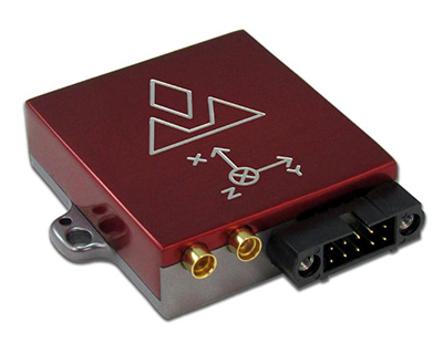
VectorNav Technologies has introduced its VN-300 dual-antenna GPS-aided inertial navigation system (GPS/INS). A follow-on product to the VN-100 IMU/AHRS and VN-200 GPS/INS, the miniature, high-performance VN-300 enables a wider range of applications through the incorporation of GPS compassing techniques.
The VN-300 can be used in a wide variety of industrial and military applications, and is well suited for size, weight, power, and cost (SWAP-C)-constrained applications such as unmanned vehicle systems; antenna, camera and platform stabilization; heavy machinery monitoring; robotics; and primary or secondary flight navigation, among others. The VN-300 will be on display and available for review at VectorNav’s booth #330 at AUVSI in Orlando May 13-15.
Incorporating the latest MEMS sensor technology, the VN-300 combines 3-axis accelerometers, 3-axis gyros, 3-axis magnetometers, a barometric pressure sensor, two GPS receivers, and a low-power microprocessor into a rugged aluminum enclosure about the size of a matchbox. When in motion, the VN-300 couples the position and velocity measurements from the onboard GPS receivers with measurements from the onboard inertial sensors to provide position, velocity, and attitude estimates of higher accuracies and with better dynamic performance than a standalone GPS receiver or Attitude Heading Reference System (AHRS).
The dual GPS receivers incorporated into the VN-300 provide the added benefit of accurate True North heading measurements when the sensor is stationary through the use of GPS compassing techniques, the company said. The VN-300 is designed for applications that require a highly accurate inertial navigation solution under both static and dynamic operating conditions, especially in environments with unreliable magnetic heading and good GPS visibility.
VN-300 Differentiating Features:
The VN-300 has small size, low weight, and low power requirements.
With Development Kits priced around $5k USD, the VN-300 is a fraction of the cost of similarly performing dual-antenna GPS/INS systems and is competitively priced with other MEMS-based GPS/INS systems that do not provide the dual-antenna moving baseline RTK features.
The GPS compass feature coupled with the GPS/INS capabilities on the VN-300 enables applications that require high-accuracy position, velocity, and attitude measurements under both static and dynamic operating conditions.
The algorithms on board the VN-300 enable applications to seamlessly transition between static and dynamic operations without having to collect extended stationary measurements or perform specific dynamic maneuvers in flight for attitude alignment.
The VN-300 incorporates a “True INS Filter” that does not force any requirements on alignment of the sensor to the velocity direction of a platform or specify the orientation of the sensor for initial alignment.
“The VN-300 is unique in that it provides a complete, high performance GPS-aided navigation solution under both stationary and moving conditions, all in a miniature and cost-effective package,” said VectorNav President, John Brashear. “By addressing some of the most difficult issues users face when trying to integrate an inertial navigation system — high cost; large size, weight and power; unreliable magnetic environments; and restrictive operating requirements — the VN-300 will enable an unprecedented number of applications.”
The Leica iCON CC55 controller is part of the Leica iCON portfolio.
Leica Geosystems now offers the Leica iCON CC55 controller, a versatile and rugged PDA with a 3.5-inch color display, as part of its iCON construction portfolio. The handheld controls Leica iCON sensors, runs the iCONstruct field software, and has a QuadraClear sunlight readable display and a fast 1-GHz processor.
The smaller Leica iCON CC55 handheld controller, as well as the seven-inch Tablet PC Leica iCON CC65/66 field controller, are both fully integrated into Leica Geosystems’ iCON portfolio of hardware and software solutions. It runs the Leica iCON build or site software to display and connect measured points for as-built data capturing or to lay out points and construction lines directly from the digital construction plan. The controller provides flexible options for data communication and an extensive data storage.
The Leica iCON CC55 can be used to control the Leica iCON robot total stations, enabling one-person operation, saving time and increasing productivity for construction layout tasks and as-built checks, the company said. The optional Long-Range Bluetooth allows communication with the iCON robot 50 at distances of more than 350 m/1150 feet. Alternatively, the iCON CC55 can be used as a data logger with the Leica Builder manual total station. Together with the versatile Leica iCON gps 60 SmartAntenna, the iCON CC55 creates a compact and light-weight GPS rover system.
The iCON CC55 runs the state-of-the-art Windows Embedded Handheld 6.5 operating system and comes with 256MB NAND Flash memory and 8 GB of extended storage, enabling extensive data process and storage capacity. An internal WLAN module and Long-Range Bluetooth offer users impressive distance communication, the company said, and the longer life 5.6Ah battery lets users easily complete a full day’s work. The iCON CC55 also comes equipped with a 5-MP camera so users can document their construction projects.
Visual Intelligence has announced that its iOne Software Sensor Tool Kit Architecture (iOne STKA) is available for purchase or licensing by manufacturers of unmanned airborne vehicles (UAVs) who want to deliver an integrated UAV/geospatial imaging solution to customers.
Capturing high-resolution imagery for applications in engineering, construction, urban planning, military missions and other uses is a significant emerging market for UAV manufacturers, and Visual Intelligence’s iOne STKA makes it possible to bring high-resolution geospatial sensors to UAVs, the company said. By purchasing or licensing Visual Intelligence’s geospatial imaging platform, UAV companies can meet emerging demand for geoimaging solutions that combine the benefits of UAVs with the imaging capabilities of a geoimaging platform.
iOne STKA provides the technology foundation to configure a variety of multi-purpose sensors, including miniaturized 2D/3D applications, for the emerging UVS and mobile/handheld markets. The iOne STKA received the Geospatial Forum 2013 World Technology Innovation in Sensors Award, is the first to be considered for NEANY’s Arrow UAV, and is field-proven by the commercial large-format 2D/oblique/3D multipurpose metric mapping systems iOne IMS, iOne Stereo, and iOne n-Oblique.
With the iOne STKA, the same UAS/UAV sensor system architecture can be used for agricultural and forestry mapping, pipeline or corridor monitoring, utility assessments, aerial surveys, research, persistence surveillance and other metric 2D/3D professional applications. The iOne STKA is a modular multipurpose sensor platform reconfigurable for UAVs of any size. With the iOne STKA, UAV manufacturers are no longer limited to offer monolithic, single purpose DSLR type cameras. Using the iOne STKA technology, UAV end users can economically collect high-quality color or infrared NADIR, oblique, or video imagery as well as co-mount and co-register e.g., LiDAR and thermal sensors using the same system architecture.
“By providing UAV manufacturers and end-users with one reliable and performing end-to-end standard digital sensor system solution for MANY applications, we are empowering our customers with a more efficient and standard technology foundation and paradigm to grow their business, enhance their products, and maximize their return,” said Visual Intelligence President and CEO Dr. Armando Guevara.
At the core of the iOne STKA is Visual Intelligence’s Patented Advanced Retinal Camera Array (ARCA). Developed using open systems and object-oriented software engineering principles, the ARCA is “encapsulated” with a rich set of advanced proprietary software methods that integrate camera components. The ARCA enables the collection of different types of imagery, fused in one pass, producing low-cost, extremely accurate, high-resolution products. It also enables unprecedented array-based collection and functional scalability sensor fusion. The arrays made of these varied imaging devices perform like a single camera, producing one single metric, radiometrically and geometrically correct image, or set of co-registered and fused images; such as a Virtual Frame, of higher accuracy, resolution and quality than DSLR-based monolithic cameras.
Adds Guevara, “UAV manufacturers can take advantage and offer bundled with the iOne sensors Visual Intelligence’s advanced computing technology for fast cloud-based basic and advanced actionable information product generation. As a fully automated solution (from the sensor to the cloud), the iOne STKA includes processing software that uses streamlined workflows and processes imagery faster with multicore/multithreaded/GPU computing technology, making it easy to quickly produce and analyze products in a device-content eCosystem environment. This technology/business model is designed to provide UAV manufacturers and users recurrent ROI.”
UAVs built using sensors based on the iOne STKA have the following features and advantages:
Strong digital obsolescence resilience, extending the useable life of the system while improving operational efficiencies and reducing operating costs for an even better ROI.
In the field:
Collection scalability
Functional scalability
Sensor reconfiguration, e.g. increase collection or functionality as needed or per mission requirements.
Large cross-track and FOV collection through smaller aperture (ARCA enabled).
Ability to collect different sources of metric imagery that can be fused in one pass.
Sensor fusion: Ability to co-mount and co-register in a “small and tight packaging” the EO capability with any other EO or active sensor such as LiDAR, Thermal, IR, etc.
The iOne STKA software architecture is normative across all ARCA-based products; that is, the software is the same for different array configurations or sizes. This reusable component approach yields economies of scale in the manufacturing and use of multipurpose UAV/sensor configurations.