The Department of Defense announced that U.S. Air Force Space Command will begin broadcasting Civil Navigation (CNAV) messages on all operational GPS satellites capable of transmitting the L2C and L5 signals. L2C and L5 are the first of several new civil capabilities being added to GPS as part of the GPS modernization program announced in 1999. The L2C signal is designed to meet commercial needs and L5 meets safety-of-life transportation requirements.
“We have been working in partnership with the U.S. Department of Transportation (USDOT) to enable early delivery of two more civilian frequencies from the GPS satellite constellation,” said Maj. Gen. Robert E. Wheeler, DoD deputy chief information officer, C4 and Information Infrastructure Capabilities. “These new CNAV messages will enable manufacturers to develop and test advanced civil receivers and make for a more robust Position, Navigation and Timing (PNT) solution available to the civilian public. We do not anticipate any GPS satellite outages or legacy degradations as a result of the pre-operational deployment of these frequencies, and those currently using the GPS Standard Positioning Service should not be impacted,” he added.
The implementation will take place in two phases. First, on April 28, 2014, the initial broadcast of CNAV message-populated L2C and L5 signals will occur at a reduced data accuracy and update frequency compared to the legacy GPS signals in wide use today. Second, in December 2014, CNAV data updates will increase to a daily rate, bringing L2C and L5 signal-in-space accuracy on par with the legacy signals. However, derived position accuracy cannot be guaranteed during the pre-operational deployment of the frequencies. These pre-operational signals are primarily used to test various equipment and should be employed at the users’ own risk; not used for safety-of-life or other critical purposes.
The Air Force will broadcast L2C messages with the health bit set “healthy,” as was the case during a June 2013 test. L5 messages will be set “unhealthy,” but as greater experience with the L5 broadcast and implementation of signal monitoring is achieved, this status may change upon review. The public will receive ample notification before any decision to set the L5 health bit to “healthy.”
“The U.S. Department of Transportation is pleased with the collaborative effort and work of the CNAV tiger team, formed between the Office of the Secretary of Defense, Air Force Space Command, and the U.S. Department of Transportation, to address concerns about implementation of a pre-operational CNAV capability on the GPS L2C and L5 signals,” said Greg Winfree, assistant secretary for research and technology at USDOT.
For additional information about the testing, contact the Air Force Space Command public affairs office at 719-554-3731.
Trimblehas released a new GNSS-based machine control solution to improve efficiency of bulk earthworks and landfill compaction operations. Installed on a four-drum soil or landfill compactor, the Trimble CCS900 Compaction Control System allows a machine operator to make more uniform and efficient passes, report compaction production data in the field, and ensure target compaction is reached with minimal fuel usage and machine wear.
The announcement was made at WasteExpo 2014, North America’s largest solid waste and recycling tradeshow.
CCS900 for Bulk Earthworks. The CCS900 system tracks compaction passes in real time with easy-to-read color mapping on the in-cab display. It improves bulk earthworks operations by ensuring fill material is adequately balanced and uniformly compacted from the bottom up.
CCS900 for Landfills. Landfill operations require contractors to compact the maximum amount of waste into the smallest area of vertical and horizontal cell space. Using CCS900, landfill owners can ensure that cell space is optimized, voids are eliminated and layers are compacted to their target density more efficiently. With real-time mapping on the in-cab display, the operator can avoid unnecessary passes that waste fuel and cause additional wear on the machine. The system also collects as-built layer information for in-field reporting and tracking of daily volumes.
In-Field Reporting and Printing for Quality Control. For both soil and landfill applications, Trimble CCS900 offers extensive in-field reporting options, including in-cab report generation and printing. This functionality allows compaction production analysis to be carried out in the field instead of waiting until data is transferred back to the office. Compaction progress and problem areas are indicated on the in-cab graphical control box and listed in the in-field report so they can be addressed immediately, instead of at project completion when re-work is more costly. An optional serial printer in the compactor cab also enables supervisors to sign off on the completion of the compaction work in the field.
CSR plc and OriginGPS have announced a series of high- performance GNSS modules using CSR’s SiRFstarIV and SiRFstarV product lines.
The new modules are 70% smaller than current solutions and deliver a 30% reduction in Time To First Fix (TTFF), making them ideal for health and fitness trackers, sports watches, medical devices, wearable action cameras, and digital still cameras. All modules, including the newly released 7 x 7 millimeter Multi Spider (ORG4572) solution, integrate the LNA, SAW filter, TCXO, RTC crystal and RF shield.
“To accelerate market adoption of location technologies in wearable devices and cameras, manufacturers must minimize the embedded GNSS module size without compromising on performance, sensitivity, or power consumption,” said Anthony Murray, senior VP, Business Group at CSR. “By leveraging CSR’s industry-leading GNSS solutions and collaborating with OriginGPS on module development, we have achieved this objective.”
The OriginGPS modules offer high sensitivity resulting in shorter autonomous and aided TTFF, better navigation stability, and higher accuracy in harsh environmental conditions. In real-life testing of the module in camera applications, TTFF performance improves by over 30 percent compared to other solutions. The module also delivers TTFF results in less than one minute over 90% of the time (cold starts).
In addition to its small footprint, the GNSS module’s ultra-fast geotagging capability dramatically improves the consumer experience. The GNSS antenna module’s outstanding sensitivity and OriginGPS’ proprietary Noise Free Zone (NFZ) technology for faster position fix and navigation stability provides geo-tagging availability even under challenging satellite signal conditions such as low signal areas, under dense foliage, in urban canyons, and during motion-based activities. Battery life is considerably extended as a result of CSR’s breakthrough low power Push-to-Fix (PtF) technology, which rapidly establishes a valid position fix enabling the module to hibernate for longer periods of time. Push-to-Fix is an intelligent periodic low power mode that adaptively changes power depending on the operating environment and motion conditions. Advanced algorithms and a powerful on-chip DSP processor maintain high accuracy (QoS) while achieving the lowest power level possible for the given environmental and motion conditions.
“As the wearable technology and action camera markets continue to grow, we must ensure that our solution meets the market’s need for high performance and small form factor GNSS modules,” says Gal Jacobi, CEO of OriginGPS. “It is our privilege to partner with CSR and its excellent engineering team to meet the market’s need. CSR’s leading multifunction semiconductor platforms and OriginGPS’ miniaturized high performance modules create a unique value proposition for customers in these markets.”
OriginGPS modules are currently in mass production, and additional information can be found at www.origingps.com.
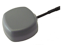
Tallysman Wireless, Inc., is offering a family of very low power, compact, high-performance GNSS antennas for precision, commercial, and military applications.
Based in Ottawa, Canada, Tallysman Wireless, is a designer and manufacturer of high-performance GNSS, Iridium, and Globalstar antennas and associated components.
The TW4327 and TW4329 are low-power GPS L1 + GLONASS G1 antennas that feature current consumption of 1.75 mA typically and parametrically invariant performance over a supply range from 2.5V to 12V.
The TW4327 o ffers a 21-dB gain minimum, and the TW4329 includes a narrow pre-fi lter to prevent front end saturation by near out-of-band interfering signals.
Both antennas are more tolerant to detuning eff ects caused by the operational environment, thanks to a 40% thicker patch element that provides wider bandwidth than conventional antennas. These antennas are also very compact (38mm x 38mm x 14.4mm), making them ideal for use in a wide range of locations.
The TW4027 and TW4029 are equivalent antennas for reception of GPS L1 signals.
“These products are ideal for any battery operated applications where low power is a pre-requisite,” said Gyles
Panther CEO of Tallysman Wireless, “and the wider patch element bandwidth will minimize detuning in non-ideal
environments, such as in covert applications.”
Tallysman Wireless has recently added an authorized distributor of its products for Russia (Aurora Mobile Technologies), and another distributor for Asia (Advanced Information Technology, Inc.), for the countries of Vietnam, Hong Kong, Singapore, China, Indonesia, and India.
Facebook Nearby Friends feature helps people get together.
While Facebook has made big news buying companies for billions of dollars, it hasn’t been making many location-based services headlines. The recent announcement that it is rolling out a friend finder is interesting news, not only for social applications, but the potential indoor positioning markets. The news is also interesting because as many as half of Facebook users access the social media network through mobile devices.
Signaling that it does have a location strategy, as GPS World reported earlier this week, Facebook announced that it was launching an LBS offering called Nearby Friends. The opt-in service allows users to find out what friends are nearby or mobile.
Nearby Friends will be available on Android and iPhones in the U.S. market this month. In Facebook’s press announcement, apparently privacy is a big issue as the company insists it is an opt-in function.
Once users agree to use the service, they will be notified when friends are in close proximity. Users can select the friends who can see their location — and can turn the service on or off at any time.
At first glance, Nearby Friends could be a valuable tool for users looking to find friends and make plans, but the real potential could be for retailers who wish to drive in-store traffic. Users can not only invite friends to a specific business on a map, but tag other traffic.
The area or business to where the friends are traveling will be displayed on their profile. This allows the friends who opt in to recommend shops, restaurants and other things to do in the specified area.
How retailers get their message out to Nearby Friends users remains to be seen. Research company Berg Insight still says advertising will constitute the main revenues for social networking and local search market segments. However, in several published reports, users have tired of the increased Facebook advertisements.
Berg says that social networking and entertainment has now overtaken mapping and navigation as the largest location market. The company says that those services include general social networking, messaging apps, friend finders such as Nearby Friends, and games.
While Facebook could use the Location History in Nearby Friends to make money selling ads, the company says it isn’t right now. But it has to be the future — and one that, privacy issues aside, could be very lucrative for the company. It could target opt-in users with ads that are only a few feet away or in the area they will meet friends.
The Wall Street Journal reported that Facebook will leverage its user base, estimated at one billion users, to improve ad targeting, expand marketing reach, and to make more money. The company earned $1.24 billion in revenue through mobile ads for the last three months of 2013, according to published reports.
After the announcement that Facebook was launching Nearby Friends, a number of tech business articles sprung up about potential, real and imagined, privacy issues. With the predictable privacy issues comes opportunities for location startups. A new location app is touting itself as the “anti-social networking” tool. Called Cloak, and available in Apple’s App Store, it allows a user to avoid friends they want to avoid by revealing the location of contacts — while keeping the user’s position hidden.
The app, which already has been downloaded more than 100,000 times, uses Instagram and Foursquare data, and published reports say Facebook compatibility is coming soon.
Rumors about Acquisition Prove False?
Earlier this month, several tech business industry publications wrote that Israel-based indoor navigation startup ShopCloud was in talks with Samsung to sell the company for as much as $90 million. Samsung has denied the rumors.
In articles like these, red flags always include terms like “several sources familiar with the details”. The price seemed high for a young company that hasn’t launched a product, though according to published reports, it has an app called Inside.
One analyst says that the Israel tech business media frequently pumps up local companies and even creates buzz for startups — and often these reports are picked up by local journalists.
Autonomous Vehicles Will Happen, but When?
In January’s Transportation Research Board (TRB) meeting in Washington, D.C., attendees agreed that self-driving vehicles are the future. The bottom line is when is the future? “We have seen the business case for autonomous vehicles — it will be a reality. When you look at the number of lives it will save, efficiency of the network, it is very compelling,” said Kevin Link, Verizon senior vice president and general manager, China. “We have to begin a slow migration of educating consumers — one of those ways is through the connected vehicle. I don’t think consumers are there yet.”
Link talked about autonomous vehicles at the Consumer Telematics Conference, also in January, but those at TRB are mainly academics and government officials, not business executives. Most believe it will take decades, Google car aside, to have a fully autonomous vehicle on the road. Others believe that if Detroit does not take notice, they can read about Google dominating this vehicle market, not being a player in it.
In other location news:
Place, the Business of Location conference will be July 22 in New York. Executives from SK Telecom, Thinknear, Sonic Notify, Aisle411, and Factual will join Google, retailer Alex and Ani, and agency MEC North America (WPP), among others. The conference will include case studies and explore how mobile, offline tracking and indoor location will change the future of digital marketing and brand advertising. Many location conferences have died in the last two years, so it is refreshing to see a conference with a strong agenda back on the scene.
Finland-based IndoorAtlas rolled out an indoor mapping application for iOS. While iOS supports Apple’s iBeacon micro-fencing solution for indoor positioning, IndoorAtlas uses the compass chip built into smartphones and does not require external hardware such as Bluetooth beacons or Wi-Fi to determine location, the company said.
The U.S. Patent and Trademark Office awarded Apple a patent that could drive technology on the next generation iPhones. The patent describes a system that combines GPS, Wi-Fi access points, and on-board location databases to provide mobile devices positioning data in all types of environments, particularly indoor location.
Concerns about data privacy aren’t going away and, in fact, are growing. Many retailers that have adopted in-store tracking technology to enhance shopping experiences and gather information on customer behavior have met with backlash. Increasingly, people are turning to a new crop of apps to safeguard how personal information is used in other apps. We have apps to guard other apps. The world is getting more confused and scary. The Heartbleed bug and other threats have heightened concern about an even more threatening vulnerability of our connected world. So how will drivers feel about increasingly automated vehicles that generate huge masses of data of an exceedingly personal nature? What happens when it is hacked?
Automated vehicles require multiple types of sensors to obtain information about the vehicle, its movement, and the surrounding environment, which includes the roadway, other vehicles, obstacles and infrastructure. All sorts of ambient information may be captured. Perhaps activity outside of your house, or your kids on their way to school, or the licenses of cars in your driveway will be caught on camera.
The massive amount of data collected needs to be crunched, and only some of it will be processed within the vehicle. Other captured data will be sent off-board to the cloud for handling, with results then returned to the vehicle. The amount of data that will be created by automated vehicles is uncertain, but I’ve seen estimates of 1 GB per second. Whatever it is, it will be immense.
What’s collecting data in a driverless vehicle? Lidar, a laser technology that uses reflected light, is identifying everything around the vehicle with great precision. Cameras are taking pictures to detect phases of traffic lights, identify stop signs, and map road lane markings. GPS is tracking the location of the vehicles and helping with navigation. Sonar is detecting objects and measuring their distance, speed and direction. And each vehicle is exchanging positioning, braking, heading and speed data with other vehicles on the road to prevent collisions.
The data generated is both of a critical and personal nature. And data that is moving in and out of the vehicle to be processed elsewhere or to communicate with other vehicles is particularly vulnerable. The consequences are far greater than a violation of privacy or a stolen identity. The operation of vehicles is at risk to be maliciously disrupted to disastrous outcome. This isn’t an issue we can put off until driverless vehicles are closer in reach. Vehicles today are increasingly equipped with safety and entertainment features that capture critical or sensitive data, any of which could present a threat in the wrong hands.
NovAtel Inc. announces that with the release of its 6.400 firmware, NovAtel CORRECT positioning technology is now available with TerraStar’s precise point positioning (PPP) corrections. Delivered via L-band, TerraStar corrections provide decimeter-level accuracy worldwide on all NovAtel OEM6 high-precision receivers, without users having to add base-station infrastructure. Subscriptions to the TerraStar correction service are available seamlessly to customers through NovAtel’s standard sales order process.
NovAtel CORRECT optimally combines data from multiple GNSS satellite constellations with corrections from a variety of sources, to deliver the best position solution possible. The strategic importance of TerraStar’s decimetre-level correction service to NovAtel’s product offering is reflected in the recent purchase of TerraStar parent company Veripos by Hexagon.
“The OEM nature of TerraStar’s correction service makes them a perfect partner for NovAtel,” stated Sara Masterson, New Business Development Manager for NovAtel. “We are extremely pleased with the performance of our current TerraStar offering and, with the ability to now work more closely together, we are very excited about developing positioning innovations for our customers in the future.”
NovAtel CORRECT is available for land, air and sea applications, providing customers with one-stop shopping for receivers, antennas and correction services. It provides integrators with the opportunity to choose pricing and subscription options that best match their OEM business objectives.
GPS IIF-5 was launched on February 20 and turned over to the 2nd Space Operations Squadron (2 SOPS) for operations on March 5. This was the 10th successful launch and initialization using Braxton Technologies‘ Launch, Anomaly Resolution, and Disposal Operations (LADO) system.
LADO has performed all the mission planning, commanding and telemetry processing necessary to prepare all GPS satellites for operational use since October 2007. Developed and sustained by Braxton Technologies, LADO was built using Braxton’s ACE Premier commercial-off-the-shelf (COTS) product line for spacecraft control, astrodynamics and simulation.
“Braxton is proud to be a key partner on the GPS program,” said Ken O’Neil, Braxton’s President and Chief Operating Officer. “As a small business, we greatly value our partnership with the US Air Force and enjoy quickly delivering innovative capabilities to support the U.S. military and the GPS worldwide user community.”
The GPS IIF-5 replaces the GPS IIA-15 satellite launched in 1994. The 19th Space Operations Squadron (19 SOPS) will control the GPS IIA-15 using LADO, where the spacecraft will be stored as a spare available for reactivation within the x-plane for the remainder of its useful life.
Facebook Nearby Friends feature helps people get together.
Facebook has started rolling out a feature called Nearby Friends. Users can turn on the feature to help them discover which friends are nearby or on the go. When notified that a friend is nearby, the user can then get in touch or meet up.
“For example, when you’re headed to the movies, Nearby Friends will let you know if friends are nearby so you can see the movie together or meet up afterward,” wrote Andrea Vaccari, Facebook Product Manager, in an article on the website.
Nearby Friends is an optional feature. Users can choose who can see whether they are nearby (such as friends, close friends, or a specific friends list) and it can turned on and off at any time. Both the user and the friend needs to have the feature turned on and choose to share that information before notifications are sent.
Users can also choose to share a precise location with particular friends for a set period of time, such as the next hour. The friend will see exactly the user’s location on a map, to help them meet up.
Nearby Friends will be available on Android and iPhone in the U.S. over the coming weeks.
Omnilink, a provider of advanced machine-to-machine (M2M) tracking and monitoring solutions, has been named to the Verizon Partner Program as a Silver member.
“U.S. government agencies, businesses, and consumers have depended on Omnilink to monitor the location, safety, and condition of offenders, assets, vehicles, loved ones, fleets, employees, and much more since 2004,” said Steve Hudson, Omnilink’s chief development officer. “We help businesses track and monitor virtually anything on almost any device, and set high standards in reliability, accuracy and ease of use. And now we are excited to make these solutions available to Verizon customers.”
Omnilink FocalPoint Offender Monitoring is an advanced electronic monitoring solution that gives government agencies the ability to reliably track and monitor the location and status of their entire offender caseload across the U.S. on virtually any device. FocalPoint Offender Monitoring combines reliable GPS/AGPS/AFLT/RF hardware, the friendliest software, comprehensive 24/7/365 support services, and state-of-the-art-infrastructure for complete offender supervision.
Omnilink Asset Tracker helps companies better manage their assets with an award-winning asset optimization, theft prevention, and monitoring and safety solution. Asset Tracker is an all-in-one asset tracking system that gives companies the ability to track and monitor the location and condition of all their physical assets—vehicles, trailers, equipment, retail, ATMs, bank bags, goods in transit, and much more — across the U.S. and beyond via their computer, tablet, and smartphone.
The Verizon Partner Program tailors regional and national opportunities for systems integrators, value added resellers, agents and solutions providers to accelerate delivery and adoption of solutions for meeting medium business requirements. In addition, the program features a tiered benefits structure that allows members the flexibility to determine levels of commitment, and also includes simple-to-use tools and clear and consistent engagement processes.
Verizon Enterprise Solutions creates global connections that generate growth, drive business innovation and move society forward. With industry-specific solutions and a full range of global wholesale offerings provided over the company’s secure mobility, cloud, strategic networking and advanced communications platforms, Verizon Enterprise Solutions helps open new opportunities around the world for innovation, investment and business transformation.
Spectra Precision has introduced the MobileMapper 20 GIS handheld. In the same form factor as the current MobileMapper 10 handheld, MobileMapper 20 offers enhanced capabilities: a new bright VGA color touch screen display, a 5-MP camera for higher resolution images, doubled memory capacity and 3.5G cellular performance.
The Spectra Precision MobileMapper 20 provides real-time GPS accuracy of better than 2 meters and post-processed accuracy of a half-meter using MobileMapper Office software. Mapping professionals can also take advantage of Spectra Precision’s optional MobileMapper Field software for data collection, maintenance and inspection.
MobileMapper 20 GIS handheld.
MobileMapper 20 incorporates a variety of communication technologies, including Bluetooth, Wi-Fi and a 3.5 G cellular modem, to keep mobile workers connected and more efficient while in the field. With a compact lightweight design, large display and long battery life (typically more than 20 hours), the easy-to-use handheld is ideal for intensive data collection. The MobileMapper 20 runs Windows Embedded Handheld 6.5 and offers the flexibility to support a broad range of third-party software applications.
“Building on the popular MobileMapper 10 handheld and responding to our customers’ evolving needs, we have significantly increased the power and functionality of our entry-level MobileMapper product portfolio,” said Olivier Casabianca, business area director of Trimble’s GeoInstruments. “With the introduction of MobileMapper 20, Spectra Precision is further extending the GIS capabilities of our customers in the field, while simultaneously providing them with the peace-of-mind of a standard two-year warranty.”
Art Kalinski, Geointelligence Editor, interviewed USGIF CEO Keith Masback about GEOINT 2013*, being held this week in Tampa, Florida. Mossback discusses new technology, future combat systems, and plans for the 2015 conference. Watch the interview above.
Kalinksi has been reporting from GEOINT* 2013 all week, with video reports. His coverage of Day Three includes visits with experts at six booths in the exhibit hall, including a demonstration of the Occulus Rift 3D glasses and an inkjet printer that produces 3D terrain models, as well as an interview with USGIF CEO Keith Mossback about the show and plans for next year.
Coverage of Day Two includes a press briefing with Lettitia Long, director, National Geospatial-Intelligence Agency (NGA); a demonstration by Airbus; and a visit to the Skyline booth.
Read his coverage of Day One of the symposium here. Included are videoclips from a DigitalGlobe presentation about the TomNod crowdsourcing efforts to find Malaysian Airlines Flight 370.