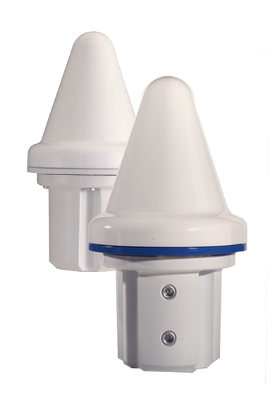
The VIC100 Series antenna by Panasonic is an active L1 GPS antenna designed for timing and synchronization. It offers immunity to noise and interference, and secure performance by attenuating noise and interference near the GPS L1 frequency through triple-filtering design.
The VIC100 Series is housed in a waterproof enclosure designed for excellent performance under severe environmental conditions. Its shape prevents accumulation of snow and ice, eliminating problems with bird perching and enhanced immunity to lightning surge.
Raven Aerostar has integrated Septentrio’s AsteRX2eH into its tethered aerostat system.
Septentrio announced today that Raven Aerostar, a manufacturer of Lighter-Than-Air (LTA) platforms, has successfully integrated Septentrio’s AsteRx2eH, a single-board dual-antenna GPS/GLONASS heading receiver, into its tethered aerostat systems.
Raven Aerostar recently completed a maritime persistent surveillance solution demonstration, deploying a TIF-25K aerostat system aboard the High-Speed Vessel — SWIFT (HSV-2), during which the AsteRx2eH performed remarkably, according to the companies. Integrating the single-board AsteRx2eH dual-antenna receiver to replace a solution based on two separate GNSS receivers allowed Raven Aerostar to achieve a reliable and accurate heading solution while also decreasing deployment time and total cost of GNSS sensors.
The AsteRx2eH provides a compact and low-power solution for precise positioning combined with accurate heading information, produced at a high output rate. The tracking of both GLONASS and GPS satellites allows the receiver to improve the availability and robustness of a solution in challenging environments.
The AsteRx2eH is a globally acclaimed OEM solution with field proven performance for land, marine and aerial applications, Septentrio said. It is used onboard helicopters and aerostats during stabilized flights hovering at low dynamics, where inertial sensors cannot easily provide a drift free solution. Another application is delivering reliable heading information for driverless ground vehicles, even at very low speeds.
“From its user interface to its accuracy and durability, Septentrio’s AsteRx2eH receiver has proven to be an exceptionally stable system,” commented Patrick Lokken, Engineering Technician at Raven Aerostar. “We have integrated the AsteRx2eH into our lighter-than-air applications in multiple environments including desert and maritime, and have yet to see it falter.”
Accord Technology, maker of NexNav products, is debuting its capabilities for enabling fully FAA compliant GPS for Detect and Avoid at the AUVSI Unmanned Systems annual convention, being held in Washington D.C. August 12-15.
Known for its certified, U.S. FAA ADS-B fully compliant GPS WAAS/SBAS sensors and receivers for NextGen solutions in the airline, business and general aviation industries, NexNav products include OEM circuit-card assembly receivers the size of a credit card as well as line replaceable sensor units.
This is the company’s first time exhibiting at the AUVSI conference.
“We are excited to be exhibiting at this show and I believe our NexNav products will fill a niche that the unmanned aircraft need,” commented Hal Adams, Chief Operating Officer for Accord Technology, LLC. “Our NexNav product already meets FAA requirements and us currently flying on many manned platforms as well as on EU UAS platforms now. I look forward to talking with attendees about the Detect and Avoid GPS solution NexNav can provide them.”
Accord Technology received TSO-C145c for its NexNav mini in 2010, and fully qualified as GPS source per the U.S. FAA ADS-B Advisory Circular 20-165. The NexNav mini GPS technology was the first GPS WAAS sensor to be authorized U.S. FAA TSO-C145c WAAS Class Beta-1 ONLY. It is a market-breaking hybrid of automotive technology and aviation requirements providing an affordable solution for ADS-B GPS source, Accord said.
TerraStar GNSS, a supplier of precision positioning services for land and near-shore applications, has established a base at Nottingham University’s GNSS Research and Applications Centre of Excellence (GRACE). GRACE operates operates under the auspices of its Institute of Engineering Surveying & Space Geodesy (IESSG).
TerraStar GNSS maintains and controls a worldwide network of more than 80 GPS and GLONASS DGNSS reference stations and associated control centers on behalf of a diverse range of users. Under the collaborative venture, TerraStar GNSS will contribute and have access to GRACE’s support facilities. These include customized incubation units, project offices, state-of-the-art test equipment, secure research and development laboratories, and dedicated training suites.
Expected projects include joint research and development of new GNSS-type solutions, in addition to provision of support for continued commercial exploitation of academic research endeavors. Also available will be mutual access to general geospatial expertise consistent with TerraStar GNSS’ present capability of providing year-round meter and decimeter-levels of precision for both land and aerial survey applications using software and a series of advanced purpose-designed integrated receivers.
Headed by General Manager Gary Wilcock, TerraStar GNSS’s new base facilities are at Office A03, The Nottingham Geospatial Building, University of Nottingham Innovation Park, Triumph Road, Nottingham NG7 2TU, UK.
Topcon Positioning Group announces new reference station network software — TopNET+ v10 — bringing new features and functionality to the TopNET+ reference station software suite.
Topcon’s TopNET+ software is a scalable solution supporting everything from a single CORS station to multiple CORS sites covering a large geographical area. Users of a TopNET+ reference network get GNSS RTK correction data generated using information from all reference stations in a network. This feature allows regional use of RTK while providing data that is specific for each local rover, Topcon said.
New features available in the latest TopNET+ v10 include:
Custom sub-networks based on a rover’s position within a larger regional network, which better supports the network RTK rover to local field conditions;
RINEX (Receiver Independent Exchange Format) shop with expanded data management functionality for conversion of data from Topcon and third party reference stations connected to the network;
Background maps and BING Maps allow multiple perspectives of the network orientation and regional surroundings;
“This upgrade of TopNET+ software provides increased capabilities and a more visual and detailed presentation of network status to the users of Topcon networks,” said Tom Morris, TPS senior product development manager. “Users will have a customized solution better adapted to local conditions and a better view into the hard processing and statistics being generated in TopNET+.”
Microsemi Corporation, provider of semiconductor solutions differentiated by power, security, reliability and performance, today announced the highest density family of single-chip timing card devices with support for both Synchronous Ethernet (SyncE) and IEEE 1588-2008 packet networks including 4G and LTE applications. The highly integrated ZL30361, ZL30362 and ZL30363 provide all of the key elements required for wireless network synchronization including support for phase and frequency. The devices are available today and are currently being designed into wireless backhaul products where phase synchronization performance is crucial.
Microsemi’s new timing devices provide the high flexibility, small footprint (13mm x 13mm) and low cost compared to alternative solutions. Key features include the availability of up to four independent timing channels; each channel can be configured to support any electrical or packet mode of operation. This allows for the simultaneous support for GPS, SyncE and IEEE1588-2008 timing. As a result, these devices can be used to enhance or to replace GPS timing in wireless infrastructure at a lower cost.
“Our new SyncE/IEEE1588 solutions provide customers with a highly compelling value proposition and very flexible architecture as evidenced by several product design-ins already in development by leading telecom companies,” said Maamoun Seido, vice president of Microsemi’s Timing Products group. “These offerings are indicative of the innovative products that have made us the No. 1 provider of network timing semiconductor solutions globally, and the new products in our pipeline will help solidify our leadership position.”
SyncE and IEEE 1588-2008 technologies allow carriers to improve synchronization and performance in packet-switching networks including the fast-growing 4G and LTE segment, which, according to a report from market research firm Infonetics, is rising from $8 billion in 2012 to a forecasted $17 billion in 2016.
Trimble has introduced the TirePulse Tire Monitoring System to assist fleet managers in reducing maintenance costs, increasing overall fleet productivity and promoting site safety. Part of the Trimble Connected Site portfolio, the advanced machine monitoring solution wirelessly reports tire temperature and pressure data from the jobsite to the VisionLink fleet, asset and site productivity management solution from Trimble. Automatic, real-time tire pressure and high-temperature alerts help fleet managers and site supervisors schedule cost-effective preventative tire maintenance, extend the life of tires, increase fuel efficiency and avoid dangerous blowouts.
Under-inflated tires can reduce fuel economy, increase overheating, tread wear and blowouts that take a machine out of production. Together, these factors can significantly affect fleet productivity and operating costs.
Trimble TirePulse can improve tire life while also reducing the need for fleet managers to drive to the site and visually inspect inflation, tire wear and temperature. Using a Trimble TP920 Industrial Tire Sensor in the tire valve stem and a Trimble SNM940 Connected Site Gateway for communications, the information is automatically relayed back to the office for analysis by the fleet manager. Accurate data is communicated through VisionLink, so the fleet manager can proactively manage tire maintenance on more machines across construction sites. Better preventative maintenance can result in improved fleet costs.
The Trimble TirePulse system also promotes increased jobsite safety by reducing the risk of tire blowout and injury to workers. Properly inflated tires improve the performance of vehicle braking systems and allow a faster response time in potentially dangerous conditions. The system is also safer and more accurate than manual visual inspection because it does not require personnel to be in close proximity to overheated tires on heavy machinery.
VisionLink automatically alerts the fleet manager or site foreman when a tire experiences a 20 percent drop in pressure and becomes a potential hazard. It can also provide a high-temperature alert to indicate that jobsite conditions are likely to accelerate tire breakdown.
“Preventative maintenance is more cost effective than a machine going down suddenly with a blown tire. But with equipment moving around so much from site to site, fleet managers struggle to stay ahead of the game,” said Julian Dann, business area director for machine control. “TirePulse is priced for installation across the entire fleet of on- and off-road machine tires, regardless of make, model or manufacturer. Increased wear or breakdown can be reported and acted upon proactively. The system can often pay for itself by preventing just one blowout.”
GTX Corp, which specializes in putting GPS technology in consumer products, and Atlantic Footcare have signed a manufacturing and distribution agreement to develop and launch GPS embedded insoles. Under the agreement, Atlantic Footcare will be making an investment of $200,000 to advance the development of the new GPS SmartSoles.
Atlantic Footcare, headquartered in Rhode Island, has been a designer and manufacturer of insoles for more than twenty years and supplies many of the major athletic and shoe companies, national retail chains, and the U.S military with high-quality and comfort insoles. Atlantic Footcare has experience in embedding electronics inside insoles through other partnerships and alliances and has completed the first prototypes of the GPS SmartSoles, which are undergoing testing.
“This relationship and investment with GTX is a great opportunity to couple technology with an insole, enabling us to produce a truly innovative and cost effective solution to meet today’s growing personal tracking needs. We are very excited at the opportunity to be at the forefront of wearable GPS tracking technology,” said Charlie Sipes, Atlantic Footcare president.
GTX Corp had been researching ways to further miniaturize its GPS module to penetrate new markets and expand current ones. “Compared to our existing module, this next gen is approximately 30 percent smaller, thinner, and lighter; 20 percent less expensive; and has 200 percent more battery life. It is equipped with a motion sensor and advanced A-GPS technology for pinpoint accuracy and rapid time to first fix,” said GTX Corp CEO Patrick Bertagna. “The opportunity to partner with Atlantic Footcare opened up and with this latest next generation device, embedding the module inside an insole was a natural next step.”
Rocky Mountain Tracking has added new GPS tracking devices that utilize CDMA cellular data networks in addition to its existing GSM-based devices.
CDMA coverage has steadily grown within North America during the last decade and is sometimes available in places where GSM networks don’t currently provide coverage. “Adding support for CDMA based devices allows us to offer our customers a choice of cellular provider based on their operational needs,” said Brad Borst, the company’s president.
“We’ve worked with our existing manufacturing and cellular service partners with the goal of being able to let our customers mix and match GSM and CDMA based devices into their fleet tracking strategy. The new CDMA devices look the same and function almost identically to their GSM counterparts,” says Borst. “CDMA devices will appeal to our customers operating in more remote locations within the United States while GSM continues to be a good option in metro areas and abroad.”
Rocky Mountain Tracking is a national GPS tracking device supplier and service provider.
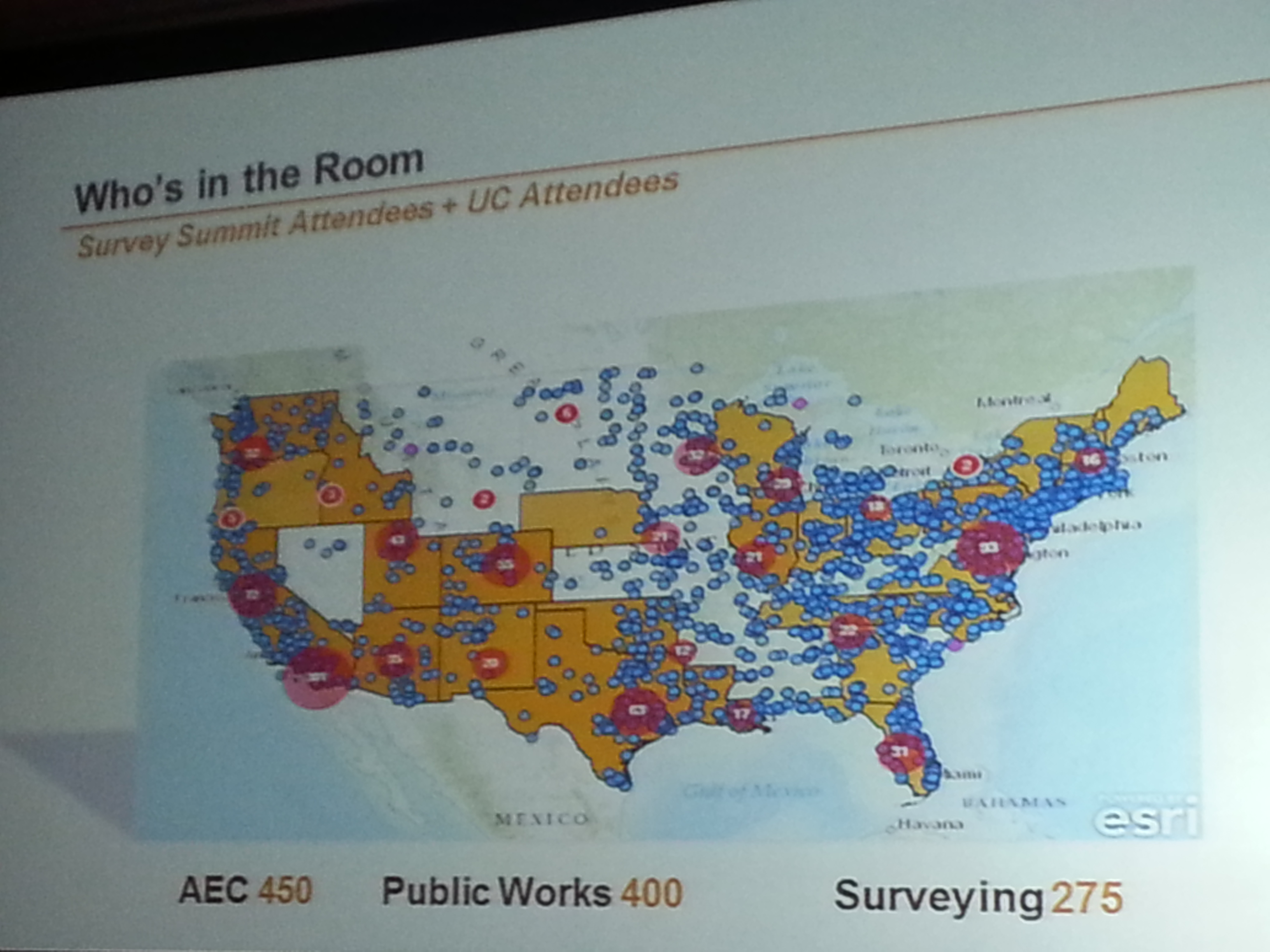
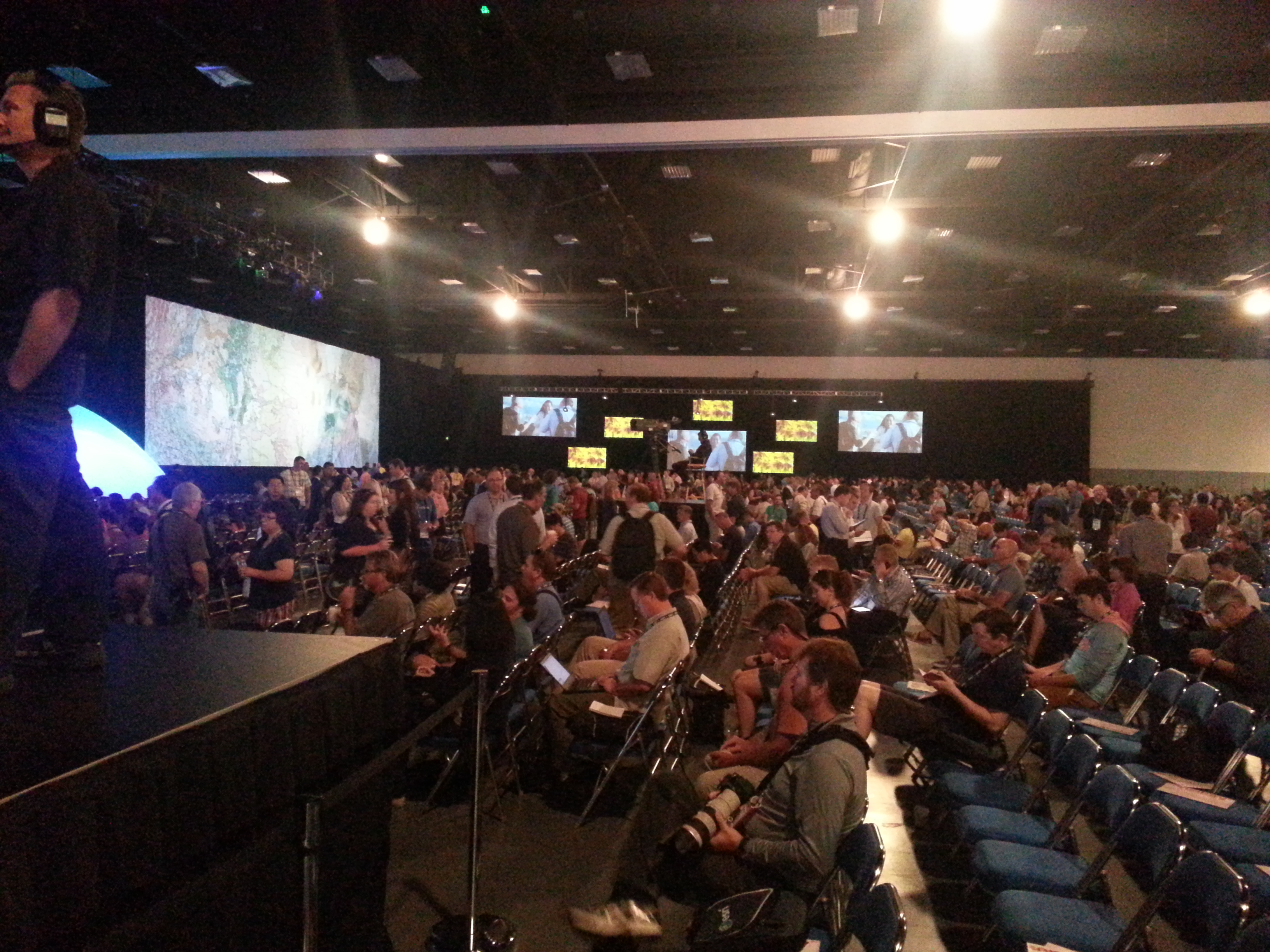
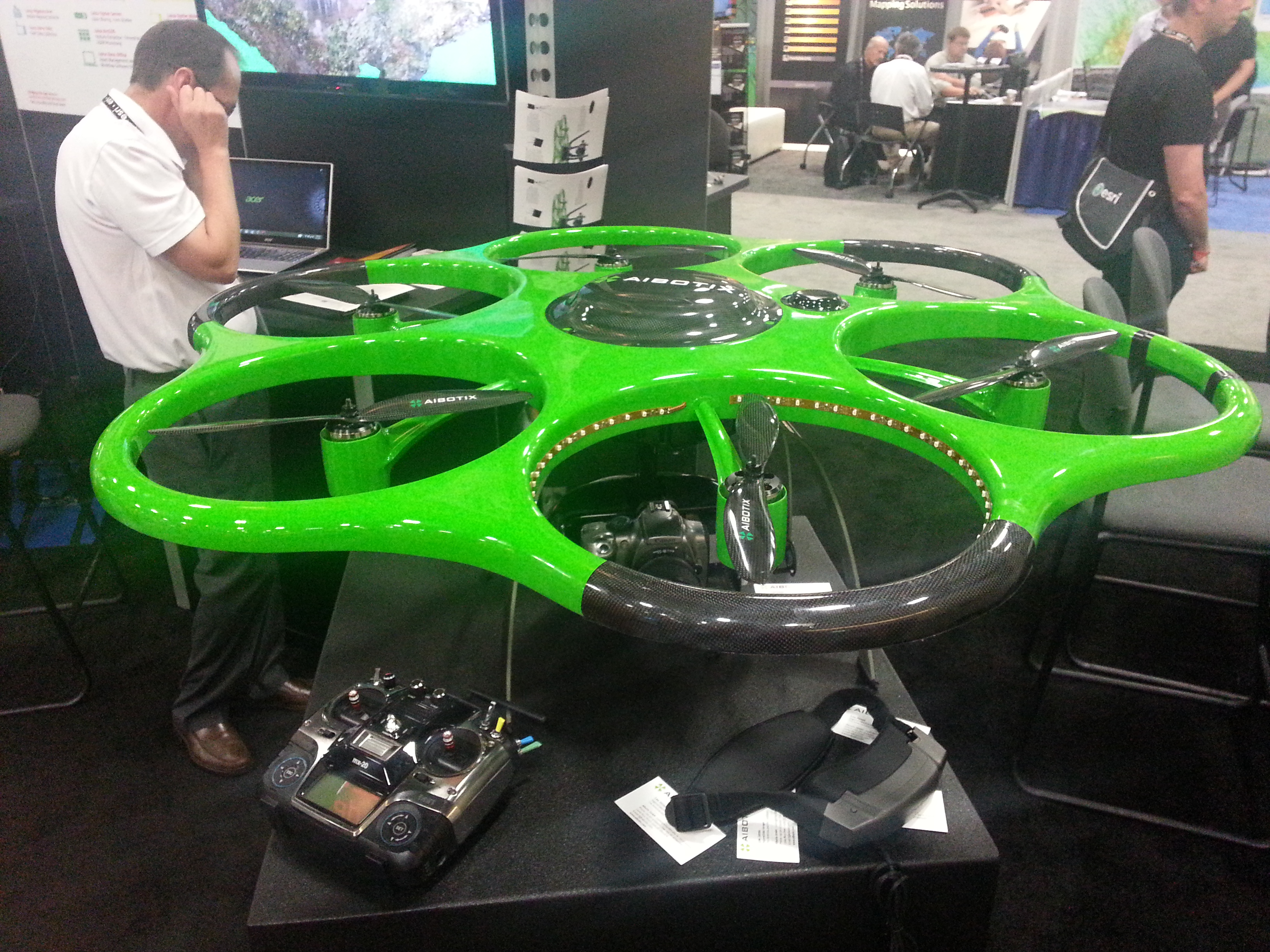
The Esri Survey Summit and Esri International User Conference (UC) were held in July in San Diego, California (they’re held San Diego every year). As always, these events are a whirlwind of spatial data technology, covering surveying software to handhelds/tablets, GNSS/GPS units, UAVs, handhelds/tablets, and plotters. There are only two conferences in the world where you will experience such a breadth and depth of hardware/software spatial technology: the Esri International User Conference (UC) and Intergeo.
The Esri UC, which is preceded by the Esri Survey Summit, is a vendor-specific conference, so you won’t see any Esri competitors there (such as Autodesk, Intergraph, MapInfo, Bentley, and Smallworld). Intergeo, set for October 8-10, is vendor-independent, so anyone can attend if you pay the fee, but it’s always located in Germany, which puts it out of reach for many North and South Americans. It’s also much more focused on business and a trade show than the UC. Finally, the Esri UC offers many more technical sessions than Intergeo. In my opinion, one of the greatest values of the Esri UC is the diverse, GIS-centric technical sessions available for about any vertical market you can imagine, from utility infrastructure to municipal engineering and wetland science. If you’re interested in browsing the technical sessions from last month’s Esri UC, you can do so here.
Survey Summit
The bulk of the Survey Summit was held the weekend before the Esri UC. This is an event where surveyors and GIS professionals (sometimes the same person) interact. The concept is solid, as surveying and GIS technologies are converging. However, this year’s Survey Summit suffered from a lack of attention from the organizers and, consequently, attendance took a hit. Only about 150 people attended, when the conference really should attract 750-1,000 people. Yes, tight travel budgets can be attributed to the decline in attendance, but there wasn’t buzz created leading up to the conference, and the content was marginal. For the first time since I can remember, there was no exhibition area for vendors. Note to Survey Summit organizers: I get that you’re busy on other projects, but if you want this to be a serious conference, you’ve got to put more energy into it.
Who’s in the Room. Survey Summit + UC.
Who’s in the Room. Survey Summit + UC.
Most interesting take-aways from the Survey Summit:
• Esri programmers responsible for the geographic datum transformations in ArcGIS were at the Survey Summit and engaged. Esri needs to do a lot of work in this area to accommodate high-precision GIS and surveying, and it seems the company is taking it seriously, but it can’t come soon enough.
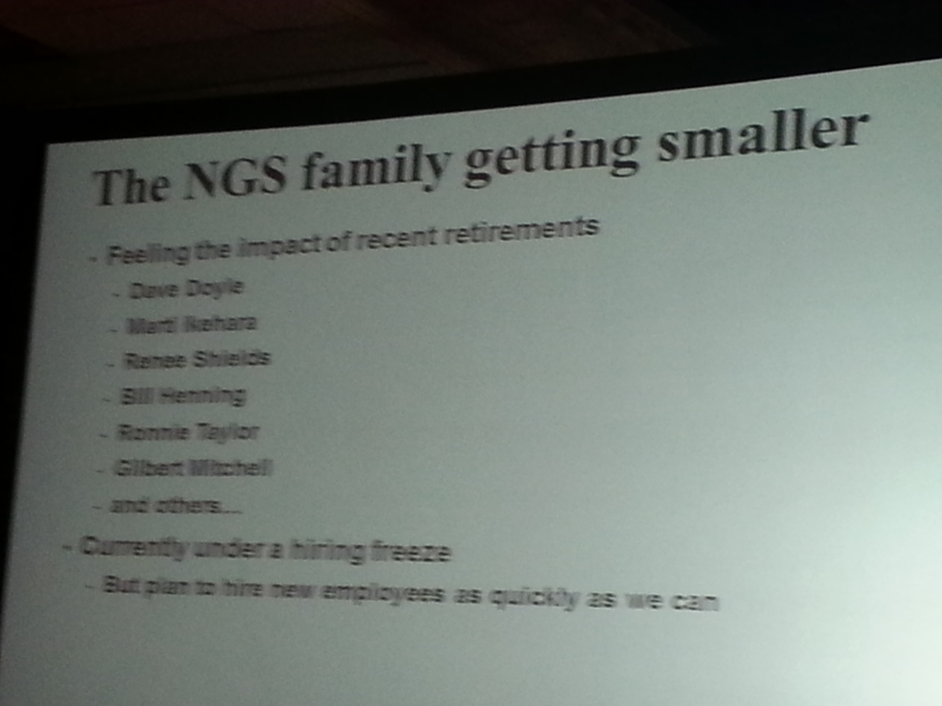
• National Geodetic Survey (NGS) usually sends a pack of people to the conference. This year, it all fell on Michael Dennis, who delivered a record number of presentations. The NGS is getting smaller. It employs about one third of the people it used to. People with a tremendous amount of knowledge and outreach throughout the years such as Dave Doyle and Bill Henning have retired recently, and there’s a hiring freeze at NGS. While geodesy for GIS is becoming more important, we are losing geodesy expertise at the federal level.
Most interesting quotes from the Survey Summit:
• “GIS isn’t an acronym for Get It Surveyed; it’s an acronym for Get Involved Seriously.” — Curt Sumner, National Society of Professional Surveyors
• “Think about what’s not going to change in the next 10 years, that’s the more important question.” — Brian Matsubara, Amazon Web Services
Esri International User Conference Keynote
The challenge is that Esri President Jack Dangermond sets the bar so high every year that there’s an expectation that he will “wow” us again. That didn’t happen this year. Mind you, I’m a huge fan of Mr. Dangermond. I love it that he’s kept Esri a privately held company (no public shareholders) and the way he dismisses investor community analysts. I love it that he has a vision, sticks to it, and yet doesn’t hesitate to make significant changes as he sees fit. He told Investor’s Business Daily, “We’ve never borrowed money,” conceding that this meant the company grew more slowly than it might have. “We had to be very, very, very conservative with money. …It drove careful decision making. We were never at the (beck) of outside shareholders or banks. What that means is we could focus on our users and employees.”
Think about a guy who, at 67 years of age, struck up a relationship with pop musician Will.I.Am, who ended up speaking in front of thousands of attendees at the Esri UC this year. You can view a video of Will.I.Am’s and other keynote conversations here. By the way, Will.I.Am says he’s going to attend the Massachusetts Institute of Technology (MIT) this fall, studying computer science. I’m impressed.
Esri International User Conference
Attendance at this year’s conference was probably down from last year, likely from reduced government travel budgets. On the conference opening day, Jack reported that 12,000 people were in attendance from 130 countries, making it the largest gathering of geospatial users in North America.
During the plenary session, four technologies were emphasized. None of them are new or earth-shattering, but each are pushing forward:
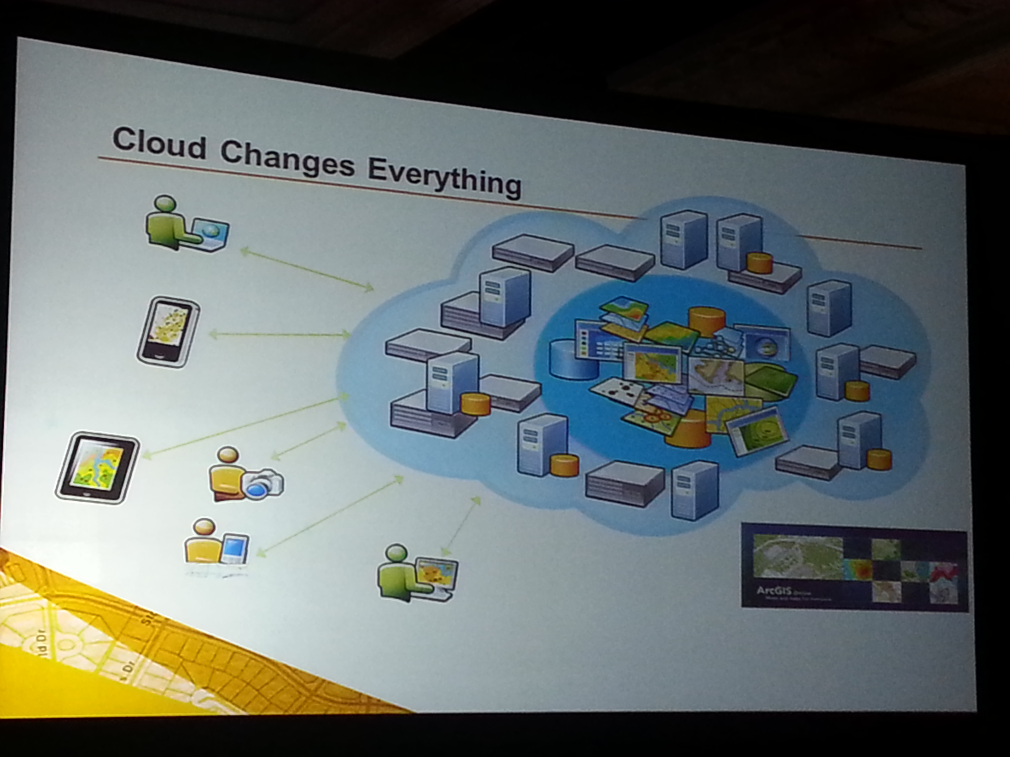
Cloud-based GIS: Esri is pushing cloud-based GIS hard. It’s a significant transformation, and there’s no turning back. During the plenary session, Jack announced that starting with ArcGIS 10.2, each license will also include a subscription to ArcGIS online. The cloud is a natural segue into Big Data.
More Data: If GIS software is the engine, then data is the fuel. More data usually translates into more apps. More granular data usually translates into better decision-making capability.
Esri reported that 100 million square miles of imagery was added or updated to ArcGIS online. DigitalGlobe announced that ArcGIS Online users will now have access to DigitalGlobe’s Global Basemap, FirstLook, and Multispectral Premium Services.
More Apps: Taking a lesson from Apple, Jack reported that “in a couple of months Esri will introduce an itunes-like appstore for GIS apps.” Seeing how GIS apps are largely customized, it will be interesting to see what this offers to the user community. It’s a super-smart idea from an Esri strategy perspective, allowing users to derive greater value from their Esri investments.
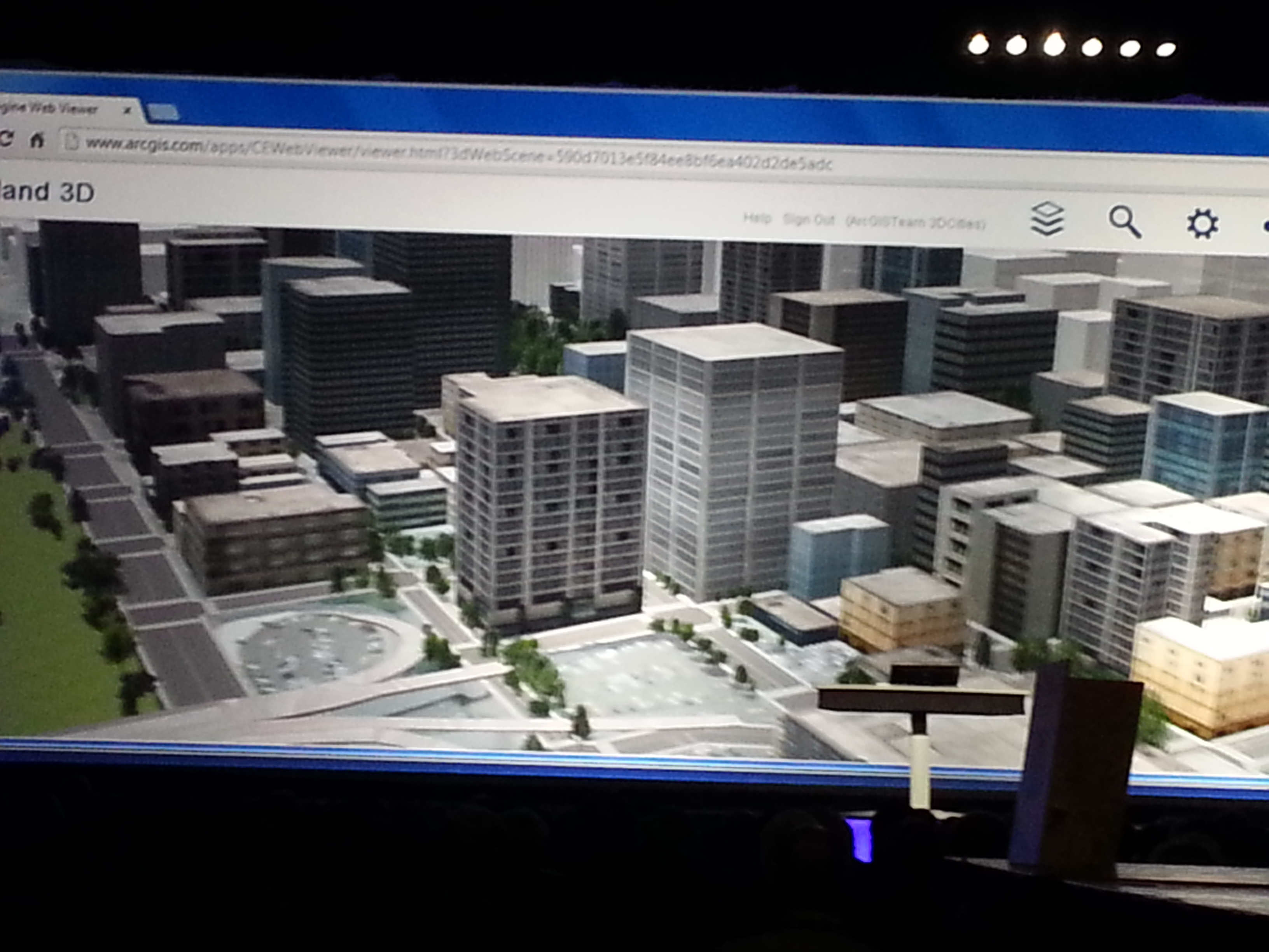
3D: Esri is spending time promoting 3D online. Jack said, “Once you get there, it’s hard to leave. 3D is a major footprint for us.” Ten years ago, I was involved with 3D visualization in landscape architecture and accident reconstruction. Generating 3D models was a painfully slow process. Jack is correct. If you can generate 3D visualizations relatively easily and inexpensively, why would you stay in 2D? This is the future. Check out Autodesks’s free Recap software for easily generating 3D visualizations from scan data and photos (even from your smartphone).
The most interesting take-aways from the Esri International User Conference:
Most interesting quotes from the Esri International User Conference:
• “One quarter of all Esri licenses are used by NGO’s or non-profits at little or no cost.” — Jack Dangermond, Esri
•”The poorest of the poor must obtain the best education possible. Information will be the fourth pillar of democracy in 21st century.” — Dawn Wright, Esri
• “In the past year, ArcGIS online has transformed from a web mapping tool to a true GIS.” — Jack Dangermond, Esri
• “Gangs are a business too, and they recruit (kids) earlier than companies do. To get a job, you have to graduate from college. What do you want these kids to be? If you’re not going to tell (them) what to do, (they’re) just going to go over here (to the gangs). Our system is broke.” — Will.I.Am
If you missed it, I along with Michael Dennis (Geodesist, NGS) were guests on the NSPS Radio Hour <ACSMJuly22_2013>. We talked about geodesy, LightSquared, and a few other subjects. It’s anMP3 file so you can download it onto your smartphone, i device or computer to listen at your convenience.
U.K. firm Chronos Technology has released the CTL3520 handheld GPS Jamming Detector and Locator System. Aimed specifically at detecting GPS jammers hidden in vehicles, the unit can pinpoint even the weakest jammer and identify the vehicle in which the jammer is hidden, even in a busy multi-storey car park, Chronos said. Other applications include detecting vehicles with jammers at ports, fleet depots, airport car parks and taxi ranks.
The CTL3520 device was recently tested by representatives of law enforcement and security agencies in screened rooms at the MIRA test facility in Warwickshire and successfully identified hidden jammers both in vehicles and people’s pockets.
The CTL3520 was developed from research undertaken by the University of Bath and is a significant commercial outcome of the Sentinel research project, which was partly funded by the Technology Strategy Board.
“Previous jamming detecting products have been unable to identify which vehicle is hosting the jammer,” said Charles Curry, founder and managing director of Chronos Technology Ltd. “This has been a particular limitation and a major challenge for people wishing to protect critical infrastructure if faced with GPS jamming emanating from a nearby vehicle. Most websites currently selling GPS jammers maintain that the operating distance of a jammer is just a few meters. This is simply not true. We have tested GPS jammers in controlled trials and their range is easily 250/300 meters which makes specific vehicle identification extremely difficult, particularly in a multi-storey car park. The CTL3520 solves this problem and can pick out one vehicle in a thousand which has the jammer installed.”
“This product contains advanced technology which is the culmination of more than two-years of research and development at the University of Bath, funded by the Engineering and Physical Sciences Research Council (EPSRC) within the Sentinel project. We are delighted that our collaboration with Chronos has led to a commercial product,” said Robert Watson, University of Bath Electronic & Electrical Engineering Department.
In addition to UK users, Chronos is seeking international resellers and distributors to take the product into critical infrastructure protection and law enforcement markets where there is a recogniszd concern about the proliferation of low cost GPS jammers used by criminals to cover their tracks or vehicle drivers for personal privacy purposes.
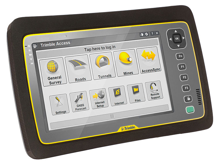
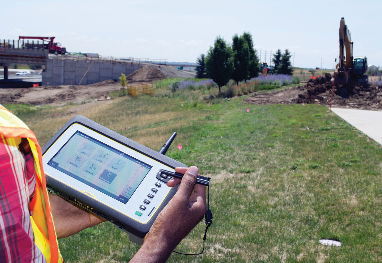
Trimble introduced today its next-generation Trimble Tablet PC for surveying. The Trimble Tablet is a lightweight, rugged and highly mobile field computer that can operate with Trimble’s suite of receivers and total stations to provide a complete surveying solution. With Trimble Access field software onboard, the Trimble Tablet streamlines the flow of information between the field and office while also allowing surveyors to run the applications they need to perform office work directly from the field.
The Trimble Tablet offers a 7-inch capacitive multi-touch screen in an easy-to-hold form factor that measures 6.3 inches x 9.6 inches and weighs three pounds. An extended battery set provides up to 16 hours of operation.
With the Microsoft Windows 7 Professional operating system, a 1.6 GHz Intel Atom dual-core processor, 4 GB RAM and 128 GB of flash-based storage onboard, the Trimble Tablet allows surveyors to run a variety of the applications they need to perform office work fast and reliably. Connectivity via Bluetooth, Wi-Fi and a built-in 3.75G GSM cellular data modem enables manageable and efficient workflows so surveyors can remain connected wherever networks are available. With the Trimble Tablet, surveyors can check their work and deliver it to clients without a trip back to the office.
Using the multi-touch capacitive touchscreen, surveyors can type, pan, and zoom with their fingers, a stylus or capacitive gloves. The large display features new technology created specifically to enhance sunlight readability. Viewing data, maps and applications is also easier so that surveyors can unlock the full potential of Trimble VISION instruments and applications dependent on highly visual data and graphic interfaces. Jobsite documentation is possible using the Trimble Tablet’s built-in 5MP camera with autofocus and built-in flash capabilities, while simultaneously providing geotag functionality using integrated GPS.
Ruggedized for extreme conditions, the Trimble Tablet holds an environmental rating of IP65 and can operate in temperatures of –30 °C to +60 °C (–22 °F to +140 °F), providing exceptional versatility, efficiency and portability. The full-color screen resides under a Gorilla Glass panel that is scratch and impact resistant.
“The ability to stay connected and complete office work from the field is becoming increasingly important to surveyors,” said Elmar Lenz, business area director of Trimble’s GNSS and survey handheld solutions. “With new features and functionality, the next generation Trimble Tablet rugged PC is an ideal solution that provides even more capability to surveyors—more memory, computing power, connectivity, data visualization, increased documentation and more.”
The Trimble Tablet rugged PC is available for ordering immediately through Trimble’s Survey distribution channel.