On June 6, the FCC, following a unanimous vote of the commission, issued an order enabling NextNav, LLC to begin commercial operation of its advanced positioning network, which is designed to support 911 emergency first responders. NextNav is deploying its nationwide network using Part 90 Multilateration Location and Monitoring Service licenses that are held by its affiliate, Progeny LMS, LLC. NextNav has been operating a fully-deployed location network for trial, testing and other non-commercial purposes in the San Francisco Bay Area for more than three years.
“We are pleased that the Commission has unanimously approved our ability to enter into commercial service,” said Gary Parsons, CEO of NextNav. “The commission conducted an extremely thoughtful review of the technical characteristics of our innovative system, and this order will allow us to offer location services that have the potential to significantly enhance 911 and public safety applications.”
NextNav’s high-performance terrestrial positioning network is designed to complement GPS in urban areas and inside structures, places where GPS is significantly degraded or denied due to blockage of the fainter, satellite-based GPS signal. The FCC-chartered Communications Security, Reliability and Interoperability Council Working Group III found that NextNav’s system delivered 90 percent smaller search rings then existing technologies in challenging indoor urban environments, and was the only technology tested capable of providing floor-level height accuracy.
The operation of this system is significantly enhanced by its use of Part 90 M-LMS spectrum licenses, which are designated for the location of mobile devices. The spectrum licenses used by NextNav cover nearly all major U.S. urban centers and over 93 percent of the U.S. population.
Trimble has introduced its next-generation Unmanned Aircraft System (UAS) — the Trimble UX5 aerial imaging rover with the Trimble Access aerial imaging application. The new solution builds upon the strengths of its predecessor, the Trimble Gatewing X100, to offer enhanced image quality and intuitive workflows. Combined with the Trimble Business Center photogrammetry office software module, the Trimble UX5 is the a complete UAS photogrammetric mapping solution specifically designed for surveyors and geospatial professionals.
Trimble’s UAS for photogrammetric aerial mapping allows surveyors and geospatial professionals to collect data with an unmanned aircraft for large projects. A wide variety of traditional surveying applications such as topographic surveying, site and route planning, progress monitoring, volume calculations, disaster analysis and as-builts in industries such as surveying, oil and gas, mining, environmental services, and agriculture can now benefit from aerial imaging by allowing professionals to safely collect large amounts of accurate data in a short time.
“With the recent introduction of the Trimble Business Center photogrammetry module and now the Trimble UX5 and Trimble Access aerial imaging application, Trimble continues to pioneer the development of UAS photogrammetry data collection and integration for geospatial professionals,” said Erik Arvesen, vice president of Trimble’s Survey Division. “The complete solution represents a significant leap in efficiency, transforming traditional workflows with faster data collection, easier processing and enhanced deliverables.”
The new Trimble Access aerial imaging application is field software for planning UAS missions, performing flight checks and monitoring flights — all with intuitive workflows. The imaging application is used to define the project area, avoidance zones, and flight parameters as well as take-off and landing locations. In the field, it is used to perform pre- and post-flight checks and download the flight data and images after landing. The new wizard-like digital checklists give the operator a complete “to-do list” so critical steps are not bypassed or missed in the field that can enhance reliable and safe flights. The software also includes fixed post-flight procedures to ensure that operators do not leave the field with a dataset that is incomplete or inconsistent.
The Trimble UX5 can provide a safer method to collect data compared to traditional surveying methods, Trimble said. Flights are fully automated, from launch to landing, and require no piloting skills. The operator facilitates the aircraft’s operation and built-in safety procedures can ensure safe and successful launches. Data collection can be performed remotely without exposing individuals to hazardous terrain, environmental contaminants or heavy equipment and machinery.
The Trimble UX5 unmanned system in use at a construction site. Photo: Trimble
The Trimble UX5 aerial imaging rover has been designed to follow the latest developments in the “prosumer” camera market, providing optimal image quality along with maximum photogrammetric accuracy.
Incorporating a mirrorless 16-megapixel camera with a fixed focal-length external lens, the Trimble UX5 provides high-resolution imagery and accurate deliverables. The large field of view from the camera allows the UX5 to cover 50-75 percent more area to enhance efficiency and reduce operational costs. In addition to the increase in flight efficiency, the Trimble UX5 is capable of producing 3D surface deliverables with a ground sampling distance of approximately 2.4 centimeters (approximately 1.0 inch).
Designed to operate in real-world conditions, the Trimble UX5 is capable of flights between 75 and 750 meters (approximately 246 and 2,460 feet) above ground level and can be flown in light rain and windy conditions, up to 65 kph (approximately 40 mph).
The Trimble UX5 airframe is comprised of a carbon frame inside expanded polypropylene. Impact-resistant plastics and composite fibers are used for the aircraft components, including winglets and belly plate. This design and choice of materials results in a rigid aircraft with strong torsional stability and the ability to withstand rough landings.
Performance enhancements also include the ability to execute steep landing approaches and thrust reversal for accurate and repeatable landings. The landing procedure starts 300 meters (approximately 984 feet) from the landing location allowing the UX5 to be used for jobs that have site restrictions such as buildings, towers or trees.
Orthophotos, contour maps, point clouds, digital surface models (DSMs) and feature maps can easily be created from aerial images using the Trimble Business Center photogrammetry module. Single-click processing for stitching images streamlines the office process for generating powerful deliverables, Trimble said.
The Trimble Business Center allows surveyors and other geospatial professionals to combine aerial photography with data collected from GNSS receivers, total stations, 3D laser scanners and more. By combining imagery from the Trimble UX5 and any Trimble VISION instruments, users can visualize their project from both aerial and terrestrial perspectives, measure points within the images and create 3D models of the infrastructure and terrain.
Trusted Positioning has released the Trusted Portable Navigator (T-PN) indoor location software. Available for any operating system, this mobile embedded software allows mobile users to navigate shopping centers, airports, and subway stations. No additional hardware or infrastructure required.
The T-PN combines the use of existing smartphone motion sensors with wireless updates (such as Wi-Fi and GNSS) for a complete solution with no extra hardware or infrastructure needed.
T-PN needs no additional infrastructure: This enables a consumer to navigate through an environment with no existing navigation technology. T-PN integrates with existing sensors such as Wi-Fi and GPS when available and utilizes significantly less power than either GPS or Wi-Fi positioning. The company reports that accurate positioning can be maintained while the phone is swinging in a hand, a call is answered, the phone is in a pocket or purse, or the consumer is texting.
Three-fifths of all smartphones, tablets, and notebooks shipped worldwide during the first quarter of 2013 run Google’s Android mobile operating system, independent analyst firm Canalys reports.
Manufacturers shipped 308.7 million smart mobile devices between January and March, Canalys states. Android powers 59.5 percent of all shipments. Apple’s iOS ranks a distant second at 19.3 percent, fueled by its strength in the smartphone and tablet markets, followed by Microsoft at 18.1 percent, buoyed by its relative strength in the notebook segment. Rival platforms including BlackBerry account for the remaining 3.1 percent.
Among the three device categories under the microscope, the tablet market continues to experience the fastest growth: Worldwide tablet shipments grew 106.1 percent year-over-year to 41.9 million units. Apple continues to lead tablet shipments with a 46.4 percent share, but Android-based rivals narrowed the iPad’s lead for the third consecutive quarter.
“Spearheaded by Google and Amazon, the commoditization of the tablet market has happened far quicker than that of the wider PC market,” said Tim Coulling of Canalys. “Profit margins are being squeezed and vendors without a low cost structure will find it hard to compete. A solid range of must-have accessories and a software and services strategy are vital as vendors will increasingly need to make revenue around their devices.”
Smartphone shipments eclipsed 216.3 million during the first quarter, up 47.9 percent over year-ago totals. Android accounted for 75.6 percent of all smartphone shipments, led by Samsung Electronics, which increased its volume 64.3 percent year-over-year to capture 32 percent market share. Apple’s iPhone shipment volume grew just 6.7 percent over the first quarter of 2012, the smallest increase since the launch of the original iPhone back in mid-2007.
Drivers looking for parking account for up to a third of all traffic in major cities, according to INRIX, a provider of traffic information, directions, driver services, apps, and tools to car makers and other businesses. The company’s proudct Park Service provides drivers with continuously updated pricing, hours, and availability information for participating off-street parking locations in North America and Europe. The service will be available immediately with all active Audi connect accounts. In the U.S. market, the service brings new benefits to more than 100,000 Audi models on the road today.
More than 18,000 parking locations in the U.S. and 42,000 more across Europe participate in the program. With the INRIX Park, Audi connect customers gain the ability to easily compare rates, gauge proximity to their destination and get turn-by-turn directions to parking entrances. The roster of available parking destinations will continue to grow as data on the locations and available spaces builds.
“Together with Audi we’re making it easier to get new integrated navigation services in your vehicle than it is to update your smartphone,” said Bryan Mistele of INRIX. “With drivers looking for parking accounting for up to a third of all traffic in our cities, INRIX Park demonstrates how new data driven services can help drivers save time and frustration on the road.”
Mapping turned up the heat in June, becoming a hot topic across the board. Apple ended negotiations to buy Waze, a provider of crowd sourced mapping and traffic, reportedly because the company did not want to relocate from Israel. Google quickly took Apple’s place as Waze’s buyer. With almost 50 million drivers using Waze, many via Apple Maps, Google would get another leg up in the race to own mapping. The connected car industry, gathered in Detroit last week, discussed the need for intelligibility in the market, particularly more organized categories of offerings. Also of interest this month is the backpack-mounted Google Trekker used to map the world where cars don’t go, as well as the LocationTech working group.
Surprisingly, reaction to Google’s sweeping design of new personalized maps, now in limited release, has been muted. The maps show landmarks, restaurants, and other details tailored to the user’s plans, habits, and interests that will become increasingly individualized with usage. One person’s map may include bars and public pools, another’s may include book stores and playgrounds. Google also introduced other map features like blending of Google’s place images, 360 degree views within retail shops, and 3-D satellite images of earth without a plug-in or download needed.
Connected Car Gathering. At Telematics Detroit last week, the connected car industry tried to reach much-needed clarity on the state of the connected car, with attention to standardization, consolidation, increased collaboration, and partnership. Many are trying to build a smartphone experience in the car but, “compared to a mobile phone, you’re always going to lose,” said Robert Acker of Harman. “The car is another device on the ‘Internet of Things,’ and we need to optimize that thing for consuming content while driving. Don’t make it a bigger smartphone device. That’s all Google or Apple can do. Rather, completely change the paradigm. Make it totally seamless; introduce gesture, head-up displays, steering controls. Make it truly revolutionized for the customer.”
Auto OEMs Are Changing Really. Smartphone-like capability in the vehicle is revitalizing the staid OEM industry and has encouraged car manufacturers to take more risk and speed up development time. It used to be de rigueur that a car maker would first pick a supplier like Denso to build a component, like a radio. “Now the automotive companies are first choosing a platform and layering on companies to build the solution. Tech companies are specialists,” says David Jumpa of Airbiquity. “We stand in the middle of the platform that makes it all work together.” Jumpa expects connected car services to get bundled and consumers to pay a subscription fee.
Freedom to Choose. To the unhappiness of wireless carriers, the automotive industry is planning on building cars with embedded subscriber identity module (SIM). Unlike current SIM cards that are carrier-specific, these are universal SIM cards that would enable customers to pick their vehicle’s wireless carrier and then change it at will. For OEMs, embedding SIM cards creates great efficiency. SIM cards can’t be easily replaced, as they must be soldered into vehicles because of vibration and shock. With OEMs shipping vehicles to multiple countries that have different carriers, a universal SIM card provides great flexibility and cost savings. Apple once tried to pursue an embedded SIM card and the carriers rose against it, but let’s see how the OEMs fare.
Mapping the World on Your Back. You’ve probably seen cars loaded with GPS and cameras for mapping streets. It is less likely you’ve seen mapping trikes, carts, or new photo-mapping backpack. Google uses the Trekker, a 42-pound backpack equipped with GPS and 15 cameras. Every 2.5 seconds it takes a picture as a person lugs it along trails, narrow streets, alleys, and mountains. Photos are stitched together to create panoramic images for StreetView.
Location Collaboration. A new initiative, LocationTech, has arrived on the location scene and is dedicated to individual and company collaboration on open-source software with an emphasis on location. The non-profit Eclipse Foundation, has created the working group LocationTech, led by Oracle, IBM, OpenGeo, and Actuate. LocationTech will allow companies to jointly develop and deploy components that bring location awareness to enterprise IT. “No single vendor can address the range of issues our LocationTech working group members are going to solve,” said Mike Milinkovich of Eclipse. “By creating a multi-vendor, open platform for location technologies, we intend to spur even broader adoption of location aware products, devices and services.” LocationTech might sound similar to the Open Geospatial Consortium (OGC) and the Open Source Geospatial Foundation (OSGeo); however, LocationTech offers full-service support and staffing for open-source location-aware technologies.
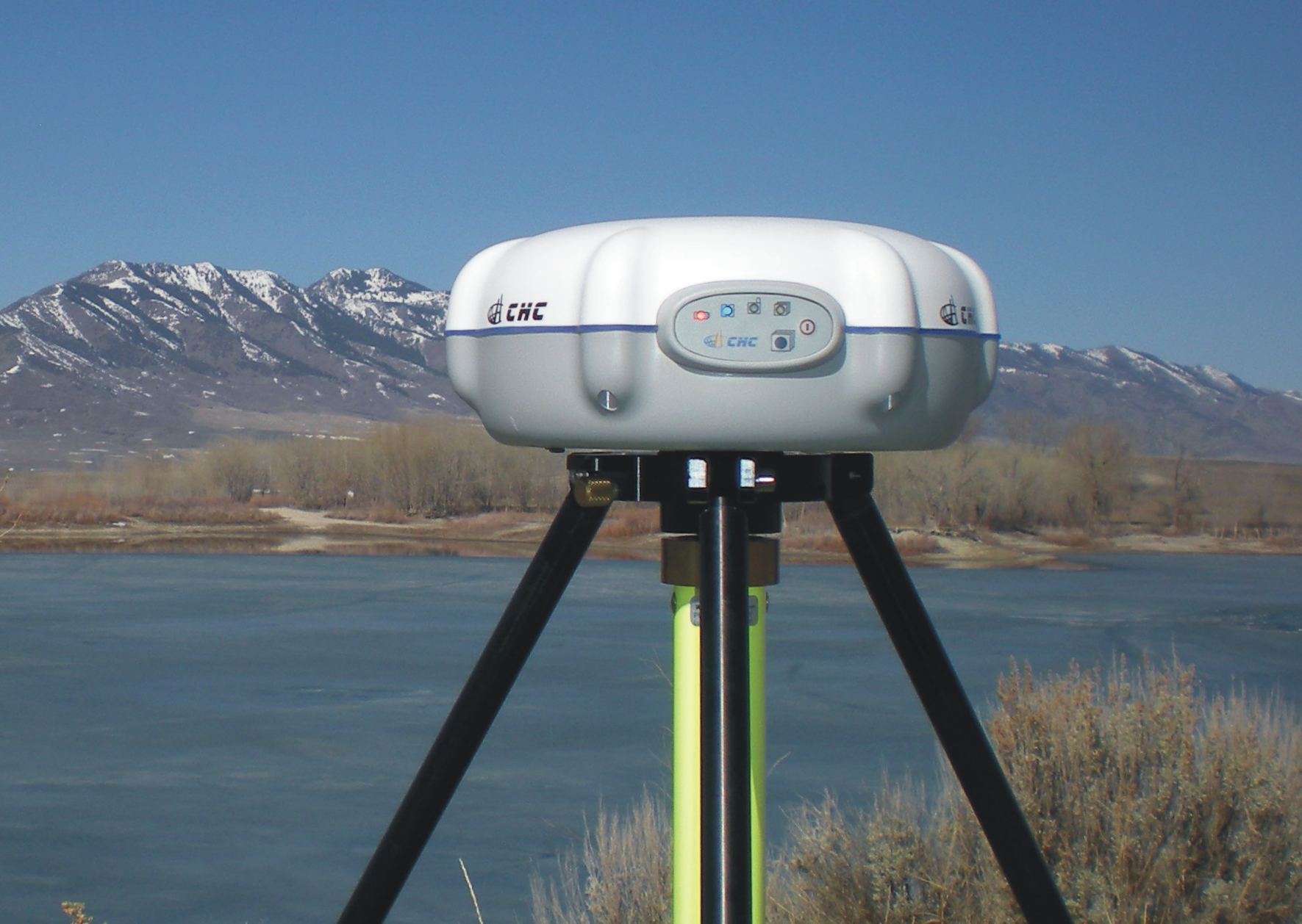
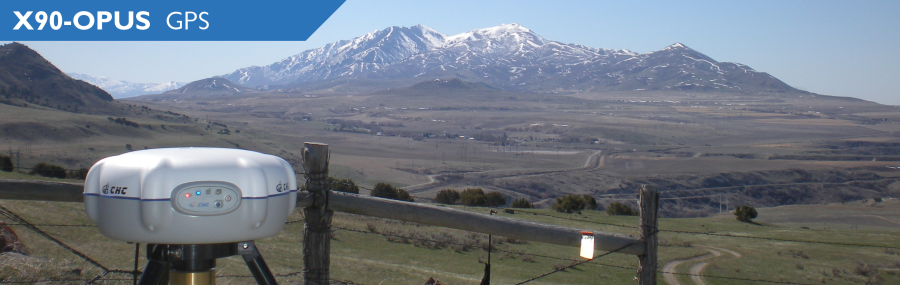
iGage Corporation announces the introduction of a simple, low-cost, L1/L2/L2C GPS receiver specifically designed to use the National Geodetic Survey’s OPUS online post-processing service. The X90-OPUS has a single button interface and customized firmware/software to automate data submissions to OPUS for centimeter-level post-processing anywhere in the United States.
At only US$2,450, iGage reports that the X90-OPUS is the least expensive L1/L2 GPS surveying receiver in the world. Its 4GB internal memory stores more than four years of 15-second interval data. A simple plug-and-play USB connection behaves exactly like a USB memory stick on the user’s computer for easy data download.
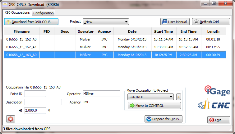
The X90-OPUS Download software has single button download. Another button press decimates occupation data, ZIPS the observation file, and automatically fills in the entire OPUS online submission form.
Photo: iGage
According to the announcement, the X90-OPUS makes field surveying easy, no data collector is required just press the power button to begin and end an observation.
“We have taken our years of static GPS surveying experience and boiled it down to a simple one-button operation,” said Mark Silver, President of iGage. “You turn it on and it works. There are no data collectors and no complicated displays. It is drop-dead simple.”
The X90-OPUS receiver is waterproof, submersible, nonincendive, and it floats (IP-67). It carries a standard two-year warranty. The package includes two rechargeable batteries, a dual slot charger, external power cable, and hard shell carrying case.
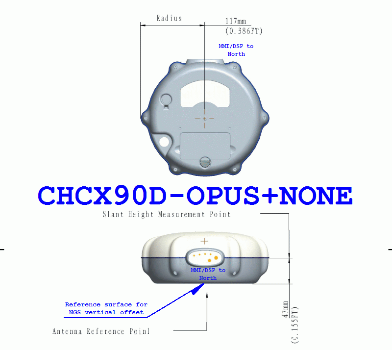
At 3.1 lbs and less than 8” in diameter, the 24-channel L1/L2/L2C X90-OPUS is ideal for surveying using OPUS, OPUS-RS, OPUS Projects, and standard static surveying campaigns. With a low cost of ownership, the X90-OPUS virtually eliminates the need for “leap-frogging” GPS receivers in large static campaigns.
The X90-OPUS is available immediately. Details are available at http://www.x90gps.com.
In the more than 100+ articles I’ve written for GPS World magazine over the past seven years, I don’t think I’ve ever written about a new product introduction like you will see below. I tend to focus on GNSS and geospatial technologies rather than a brand-specific products and services. In fact, last week I had an outline prepared for my article that included some really cool free and useful GPS/GNSS apps. I decided to set that outline aside until later, in favor of writing about this product.
Although certainly different than mainstream GPS/GNSS receivers, I wouldn’t refer to this new product as a disruptive one (a marketing term used to describe something that is industry-changing) and it doesn’t incorporate leading-edge GPS/GNSS technology. In fact, it’s relatively low-tech in comparison to the other GPS/GNSS surveying receivers available in the marketplace.
Even more fascinating is the fact that the product was developed not by any of the mainstream GPS/GNSS receiver manufacturers you hear about today, but rather an electrical engineer from Utah who leveraged the design/manufacturing expertise of one of China’s largest manufacturers of GPS/GNSS surveying receivers.
The final nail in the coffin is the fact that I’ve expended thousands of words in GPS World denouncing the future of post-processing and celebrating the virtues of high-precision, real-time GNSS (RTK, SBAS, PPP) receivers.
I tried to talk myself out of writing this article more than once, telling myself that I’ve never written specifically about a new product and I wasn’t going to start now. But, as much as I didn’t want to, I always came back because it is so darned compelling.
While the product is not aligned with my vision of real-time being the future of high-precision GNSS receivers, it is perfectly aligned with my vision that the cost of high-precision GNSS receivers are dropping and will continue to decline considerably over the next few years.
However…it is incredibly inexpensive, and it is designed to be perfectly simple to operate.
iGage X90-OPUS Photo: iGage
In one sentence, the X90-OPUS is a one-button, dual-frequency GPS receiver that is specifically designed to use the National Geodetic Survey’s free online OPUS post-processing service to achieve centimeter-level GPS positioning anywhere in the United States and surrounding countries.
You might say to yourself, “So what? There are plenty of GPS receivers on the market that are capable of providing this functionality.” I would make the same comment, except it has one product feature that I’ve never seen before.
The Price
What makes the X90-OPUS so compelling is its low cost. The X90-OPUS GPS receiver sells for US$2,450, including all software and accessories (except for tripod/tribrach) that allow you to submit GPS data files to OPUS in a very automated fashion.
At US$2,450, the X90-OPUS may open a new world for surveyors, engineers, and scientists who have previously shunned high-precision GPS receivers due to their high cost and complexity.
Simplicity
For those of you who yearn for the yesteryear of the one-button Ashtech’s legacy Locus GPS receiver, the X90-OPUS reminds me of that sort of simplicity, but on steroids. The X90-OPUS is a dual-frequency (L1/L2) receiver, while the Locus was a single-frequency receiver. The difference is that one can use OPUS and the other cannot. OPUS post-processing doesn’t support single-frequency GPS receivers. However, Mark Silver, the electrical engineer from Utah, has taken it a step further by developing software that automates the OPUS data submission process. Although I’ve made it clear in the past that I’m not a fan of post-processing, it doesn’t get any easier than this. You don’t need to buy a base station, and you don’t need to own post-processing software. It’s a two-button push operation: once to turn it on, and once to turn it off.
X90-OPUS Software Photo: iGage
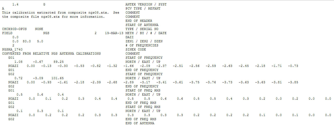
The X90-OPUS receiver was characterized by the National Geodetic Survey back in March 2013 and is listed on the NGS’s Individual Antenna Calibration website.
Photo: iGagePhoto: iGage
Pertinent Background
You might think that with the US$2,450 price point and not being offered by a major GPS receiver manufacturer, this is some home-brew GPS receiver. If you thought that, you would be incorrect. The GPS engine in the X90-OPUS is a Pacific Crest BD950, the same engine found in many receivers from other GNSS system manufacturers. CHCNav integrated the GPS engine into its casing to produce the X90 receiver. However, Mark added his own special sauce to the X90 to turn it into the X90-OPUS so this isn’t just a CHCNav receiver being marketed by iGage (Mark’s company).
In all fairness, I’ve not touched the X90-OPUS yet. I likely will in the next few days. However, unless the hardware is unreliable, I don’t see how this product is not going to be a winner, and it will introduce high-precision GPS receivers to an entirely new group of surveyors, engineers and scientists who have been holding out on using GPS.
Summary: A look at the challenge of dealing with horizontal datums in your GIS. We are moving into a new era in dealing with datum transformations. Geodata 2.0 is coming, and it can create big headaches when attempting to combine disparate geospatial databases. Sensors such as GPS receivers, remote sensing imagery, and 3D scanning provide much more accurate data, setting up a collision with outdated and mismatched legacy horizontal datums.
Speakers:
Kevin Kelly, Geodesist, ESRI, Inc.
Kevin Kelly is a Geodesist with ESRI in Redlands, California where he researches and implements geodetic algorithms and applications for the ArcGIS software. His experience spans over 35 years in hydrography, geodesy, surveying and most recently, geographic information systems. He has held the posts of Manager of Geodetic Services for the Province of Ontario, Chief Geodesist for the Kingdom of Saudi Arabia’s Military Survey Department and Senior Project Surveyor for The Keith Companies (now Stantec, Inc.). Mr. Kelly received a Master of Applied Science in Geodesy at the University of Toronto, Canada and holds an Honors Diploma in Hydrographic Surveying Technology from Humber College in Toronto. He is also a licensed Geodetic Surveyor in the Province of Ontario, Canada.
Craig Greenwald, Technical Director, GeoMobile Innovations
Craig Greenwald is the Technical Director and a principal at GeoMobile Innovations Inc. He has worked in the GPS and Mobile GIS industry for over 13 years, including seven years for GIS software leader, ESRI and is well known for his work on the ESRI ArcPad team. Craig leads the GeoMobile software development and consulting team specializing in Mobile GIS and field data collection applications and technology providing Mobile GIS software, consulting, and training services to GeoMobile Innovations? clients. Craig has real world experience designing, implementing, and consulting on all sizes of projects, ranging from local campground trash mapping to the U.S. national census, and has been a key developer in GeoMobile?s commercial applications such as LaserGIS for ArcPad and Geo-Photo Inventory Tool for Garmin GPS solutions.
Michael L. Dennis, RLS, PE, Geodesist, NOAA
Michael L. Dennis, RLS, PE, is a geodesist at NOAA’s National Geodetic Survey (NGS) where his duties include analysis of geometric (“horizontal”) and vertical datums; evaluation of data processing and survey network adjustment procedures; development and promotion of standards and guidelines; integration of NGS products and services with GIS; and public outreach. Mr. Dennis is also a registered professional engineer and surveyor with private sector experience, including ownership of a consulting and surveying firm. Mr. Dennis is an officer of the American Association for Geodetic Surveying (AAGS), an American Congress on Surveying and Mapping (ACSM) Fellow, and a member of the Arizona Professional Land Surveyors Association and the Geomatics Division of the American Society of Civil Engineers.
Moderator:
Eric Gakstatter, Editor of Geospatial Solutions Monthly and Survey Scene
Eric Gakstatter has been involved in the GPS/GNSS industry for more than 20 years. For 10 years, he held several product management positions in the GPS/GNSS industry, managing the development of several medium- and high-precision GNSS products along with associated data-collection and post-processing software.
The U.S. Air Force Space and Missile Systems Center has signed a Cooperative Research and Development Agreement (CRADA) with Space Exploration Technologies Corp., better known as SpaceX, as part of the company’s effort to certify its Falcon 9 v1.1 Launch System for National Security Space (NSS) missions. This cooperative agreement facilitates data exchanges and protects proprietary and export-controlled data. The CRADA will be in effect until all certification activities are complete.
A CRADA enables the Air Force to evaluate the Falcon 9 v1.1 launch system according to the Air Force’s New Entrant Certification Guide (NECG). As part of the evaluation, SMC and SpaceX will look at the Falcon 9 v1.1’s flight history, vehicle design, reliability, process maturity, safety systems, manufacturing and operations, systems engineering, risk management and launch facilities.
SMC will monitor at least three certification flights to meet the flight history requirements outlined in the NECG. Once the evaluation process is complete, the SMC commander will make the final determination whether SpaceX has the capability to successfully launch NSS missions using the Falcon 9 v1.1. SMC anticipates entering into additional CRADAs with SpaceX to evaluate its Falcon Heavy rocket and with Orbital Sciences for its Antares launch vehicle.
“Certifying Evolved Expendable Launch Vehicle’s for new entrants is in keeping with the Air Force strategic intent to promote the viability of multiple domestic EELV-class launch providers as soon as feasible,” said Col. William Hodgkiss, Launch Systems director.
Currently, United Launch Alliance’s Delta IV and Atlas V are the only certified launch vehicles capable of lifting NSS payloads — such as the GPS satellites — into orbit. The addition of multiple certified launch vehicle providers bolsters assured access to space by providing more options for the warfighter to place needed capabilities on orbit. While certification does not guarantee a contract award, it does enable a company to compete for launch contracts. Those contracts could be awarded as early as Fiscal Year 2015 with launch services provided as early as Fiscal Year 2017.
I first met just-pinned-on, shiny and bright, Captain Bernard Gruber-USAF in 1992. Bernie had just arrived at the Space and Missile Systems Center at Los Angeles Air Force Base in California where he would hold several important positions.
For those readers not aware of the mission and importance of the Space and Missile Systems Center (SMC), today SMC, which began in 1954, is the nation’s center of technical expertise for military space acquisition with more than 5,000 employees nationwide and an annual budget of $10 billion.
Bernie’s first association with GPS at SMC was as the chief of User Equipment Production at the then NAVSTAR Global Positioning System Joint Program Office (GPS-JPO). He went on to serve as the program manager for Foreign Military Sales (FMS), working with our allies, and then as the program manager for Advanced Military Devices, which is a euphemism for things we can’t discuss in this venue. All this in a short 40-month time frame, which is almost as long as he has served in his current capacity as the director of the Global Positioning Systems Directorate, now 21 years later. As a young starry-eyed captain, I remember Bernie as energetic, dedicated and full of ideas, which pretty much describes him today as he completes his last active duty assignment and his 26-year U.S. Air Force career draws to a close.
While it may be fair to say that Bernie had some notion of what to expect when he was assigned as the commander of the GPS Wing in 2010, he actually had no idea of all the tremendous and mostly positive changes that would occur to the GPS program under his watch.
I thought it would be fitting to conduct an exit interview with Bernie during his last full month on the job and get his opinion concerning the changes to GPS during his tenure and the probable way ahead for GPS as he turns over the reins.
Don Jewell (DJ): Colonel Gruber, thanks for taking the time to speak with us today. I know you are extremely busy and your time is running short at SMC. Bernie, you have certainly lived the old Chinese adage, also sometimes described as a curse, during your tenure as the GPS Wing Commander and as the director of the GPS Directorate, “May you live in interesting times.” Your tenure has been beset with one major challenge after another and yet you have persevered and — I think this is something for which you will be remembered — you have consistently turned those challenges into opportunities. Let’s discuss some of the opportunities.
Certainly sequestration and budget issues are big topics today. Having come from the Pentagon and having worked on the financial side of GPS, were you surprised by what you found when you took over as the GPS Wing commander? Was it all you expected it to be? The big question seems to be, how is sequestration going to affect the future of the GPS?
Colonel (USAF) Bernard Gruber (BG): Well, Don, certainly budget issues are a key topic today, but let me say before we get started on the questions and answers that I really appreciate the opportunity to speak with you and your readers at GPS World. As you said in your introduction, these have certainly been interesting times. Some people may call it crazy but they are certainly interesting, nonetheless.
I must say that I was pleasantly surprised how much had changed on the [GPS] program when I came back to SMC, and the changes were really all for the good. It warmed my heart to see the Foreign Military Sales [FMS] office — which I actually started back in 1992 — now has agreements with 55 nations, and military sales continue to increase year-by-year. I was also very happy and surprised to see the SAASM or Selective Availability and Anti-Spoofing Module program, which I was actually the program manager for in its infancy, has now been installed on over one million GPS military receivers — in my estimation this program is protecting warfighters around the globe every single day. I think that is something we can be very proud of together.
The folks in the [GPS] Program Directorate that I have had the good fortune to work with are really something special. They work their hearts out every single day to protect, modernize, and sustain this great system. Also, I continue to be very much amazed that people understand the value of GPS as part of our critical infrastructure. So, my thanks to folks like you, Don, and the folks at GPS World for educating the public on this great utility that we have.
DJ: Thank you, Bernie, for those kind words. You know we are always happy to serve.
BG: Moving on to the sequestration bill… We are working very hard to reduce our costs and invest in different opportunities that have a return on investment like dual launch [of GPS III — ed.] and NavSat, or I think it is NibbleSat, as you and Dr. Parkinson referred to it in your article from the National Space Symposium, which we look at as an augmentation to GPS III. That is a good thing because it can significantly reduce total lifecycle costs of the program. So we continue to look at these, amongst other items, that we will prioritize and spend our development dollars on — items such as Lithium Ion (Li-Ion) batteries, smart solar arrays, that allow you to have more efficient use of power, more efficient power amplifiers, that are significantly shrunk down in size from what we have today. Bottom line is we will continue to work on processes that clearly show a positive value stream.
DJ: I would think that one of your bigger, albeit not technical, challenges during your tenure was transitioning the GPS Wing back to an SMC Directorate. Any thoughts about the wisdom of that transition? Has it affected operations in a positive or negative way, or can you detect a difference? Has it affected the space career field for your military members?
BG: I remember you asking me this very same question back in 2011 during our very first interview, and I wish I remembered [ed. We remember — click the link]what I said back then, but I will give it a shot from where we are, right here, right now (laughs).
General Sheridan, as you very well know, the prior SMC Commander, had actually given me six goals when I got here. The first of those was fix the gap between OCX and GPS III. If you recall, we had about a 15-month gap in the delivery of those items. The second one was he asked me to transfer the AEP and LADO[launch, early orbit, anomaly and disposal operations, now provided by Braxton Technologies] ground segment to our users [the 50th Space Wing] and get that capability to them as soon as we could, so that they could operate it and own it. The third one was fix the IIF production line. The fourth one was to get the MGUE, or military GPS user equipment, back on track and award contracts. The fifth one was build a relationship and continue that relationship with the 50th Space Wing [Schriever AFB, Colorado]. The last one that he actually gave me was to ready the first space vehicle for GPS III through the GNST, which of course is the GPS III Non-Flight Satellite Test Bed and an engineering, manufacturing and development pathfinder for the GPS III program, used to achieve modernization. And, Don, I am happy to say that we as a team have achieved every one of those goals.
Not far behind those goals, Don, General Sheridan followed up with the task of transitioning the Wing back to the Directorate. And as far as I can tell, it has really been seamless. I have to say, though, I really miss the instant recognition that we, as airmen first and then as acquisition professionals, had when we were called Squadrons, Groups and Wings. While I certainly understand that the number of folks that we supervise may have not have justified those titles by themselves, the level of responsibility that we have and my peers have around here certainly did, in my opinion. All around the change has not affected us in any negative way, and I really don’t detect any significant difference resulting from that transition.
DJ: Bernie, you oversaw the first successful launches of the Boeing-built GPS IIF satellites — a program beset by significant schedule and costs issues. Yet it has evidently become a success under your watch, even though there are still some issues. What are your overall thoughts about the IIF program?
BG: Thank you for that, but I really share this success with many, many other people here at SMC as well as at Team Boeing. The IIF program really and truly has turned a corner. It’s delivering world-class position, navigation and timing (PNT) data right now for users all over the world. Under my watch we had the addition of three IIF satellites actually put into the active constellation today. And although a lot of people may not know it right now, we recently achieved our very best day ever on the 21st of April in terms of accuracy of the GPS signal, with average user range errors (URE) of less than 51 centimeters. That is really astounding! It is better, clearly better, than any PNT system in the entire world today.
So the IIF program, at this point, is focused on closing out the production line and certainly completing those remaining few satellites. We will ready those eight satellites for launch, and then we will support the existing on-constellation needs as they arise.
Now, the nature of space programs is such that technology issues can, of course, creep up on you at any given time. I think we have proven that we can meet those issues head-on and keep the program on track. I could not be prouder of my IIF team very specifically. I very much recall when I first walked into this program office, when we had to actually shut down the IIF production line for over a month. That was a hard thing to do, but it really focused us on closing all the discrepancy reports we had and modeling a very smooth production flow.
So, here we are now with four [GPS-IIFs] on orbit, and five in the barn. As far as I can tell, programmatic and technology challenges have really pretty much been abated to continue to allow world-class spacecraft and mission data as we look forward.
And, Don, let me also add that we successfully transitioned at that time the entire ground segment, the LADO system, which I know you are very familiar with, the systems training system, as well as the data archival system to our operators and partners at the 50th Space Wing, without one single lien.
DJ: Bernie, what you just told us is very impressive. Accuracy and standardization are critical to GPS program success, and it sounds like you have that well in hand. Of course, the seamless transition of key responsibilities to the 50th Space Wing and 2SOPS (2nd Space Operations Squadron) is to be applauded. Plus, it really appears you have the IIF issues resolved and the GPS III program has become a reality during your tenure. What are your hopes for that program? Do you think the Lockheed Martin built GPS III will truly, as some have predicted, become the first 30-year GPS satellite?
BG: The bottom line is that I sincerely hope that the GPS III program will be a benchmark for future space acquisition programs, both in terms of the high standards that were set for mission assurance, and the level of communication between our program office and the contractor. The GPS III program is entering the very early stages of testing right now on the first flight vehicle, and I anticipate that we will begin to see the program move down that learning curve in very short order. You know with the 15-year design life, which we put in the contract, along with stringent parts requirements and our priority on systems engineering, I really do expect that the GPS III satellites will operate beyond the standards set by the current constellation. And I do have to say that what we call our “back to basics” approach, that other folks have written about, which includes those attributes of strong systems engineering discipline, detailed manufacturing systems readiness reviews, and strict adherence to standards, are actually now showing tangible and documented results. In some cases a 60-percent reduction in our cycle time and a 70-percent reduction in discrepancies for the next delivered items. I think that is huge.
You know, even from an historical perspective, our pathfinder vehicle, which we talked about earlier, called GNST, has taken actually one year out of labor and interference testing from troubleshooting we have seen on two previous programs alone. So we are taking GNST through all the steps the very first GPS III satellite will be exposed to. Then we will ship it down to the Cape [Canaveral] in one month and we should be able to complete our initial and final look at integration and delivery.
DJ: Bernie, so far we have talked mainly about the successes in the space segment, while the future of OCX to many still seems very uncertain, especially in light of the latest GAO report, which had some serious issues of its own. You have been closer to this process than anyone. What are your thoughts? Does OCX have a future? There are rumors there are going to be major changes. Any announcements you would like to make or predict?
BG: The development program for the Next Generation Operational Control System has made significant progress, and has just recently completed a very critical Milestone B approval, in November 2012. As we stand right now, the program is poised to deliver the next-generation GPS space vehicle command and control capability, mainly for GPS III, of course. It will replace our legacy ground [command and control] system and will support legacy and future space vehicles, as well as all the signals that accompany them. The program at this point remains on track to deliver capabilities according to the acquisition program baseline that we set down during the recent milestone.
That said, Don, some of the recent and heavy work of information assurance criteria are extremely rigorous. In fact, they are the most rigorous I have ever seen on any program that I have been involved with. Someone once told me a few months ago, “Bernie, you know you are building an information fortress that just happens to do Command & Control.” So I don’t know if I actually subscribe to that thought, but I think it gets the point across. In today’s cyber-threat environment, we have to do this, and we have to do it right for the protection of GPS.
To give you some confidence in the program, as of today we have actually coded over 98 percent of the Block Zero system, which is the basis for launching and commanding the basic GPS III constellation and, of course, the first vehicle. And we followed that up with two very significant exercises to provide telemetry and an integrated planning system. In July, we will actually go forth with our third exercise itself. In fact, I just got off the phone with the team a few minutes ago, to exercise what we call off-nominal behavior. Those are different types of test plans we have to go through just in case something in the system goes wrong.
What that means, Don, is if something does not go according to plan, what we do is we inject faults into the system and other types of non-nominal behavior, and then we see if we can do recovery actions and how the command and control system will actually fix it and correct it. This ensures the operators will have the tools to fix it.
So, Don, as kind of an overview, along with what we call the complete authority to test the documentation that is in place right now and the conclusion, which we recently had, of our third critical design review, I think we are on our way. We will be challenged along the way, there is no doubt about that, but we are looking forward to achieving our full capability with Block One. [ed. OCX Block RTO currently scheduled to be delivered in Q1 2017.]
DJ: Bernie, that is great news for those who are worried about the future and viability of OCX. It is good to know you still see a way ahead. Now we have covered the three main segments of the program, but there are still concerns over the initial acquisition process and how that plays out over time. Certainly in your career you have been steeped in Air Force and DoD acquisition programs for years, which is a process many in government describe as a process in need of a major overhaul. What are your thoughts? How could we, the government, the USAF, do things differently? Any solutions or cogent thoughts?
BG: Sure, off the record! No, seriously, I have indeed been involved in acquisitions for a long time now, and let me just say that is a great question and it is certainly deserving of a much, much longer answer than I have time to provide for you here today. As a matter of fact, I have written a couple of papers on the subject of acquisition reform in the past, and I have been involved with three very significant studies in Defense Acquisition University (DAU) as well as one of our nation’s premier think tanks, the Center for Strategic and International Studies in Washington, D.C.
But, in my opinion, there is a lot we can do, so let me just capture a couple of thoughts here. The first one, and I have noted this one many time before, is funding and requirements stability, both in what we call the program stages and execution stage of the program, is just paramount. That said, I fully realize with sequestration and budget control measures that we cannot control budget releases from Congress, cuts or changes. But it really does create an incredible burden on our ability to deliver systems on time. The second is one is to look seriously at decentralizing execution. As has been cited in many studies before, whether those be “Beyond Goldwater-Nichols” or the DAPA Study (Defense Acquisition Performance Assessment) that some people call the General Kadish study, it is easy for anyone along the long chain of acquisition approvals to say no or to add another layer of documentation or to change, but the ripple effect of doing that as well as what it does to the system is just overwhelming.
And I will say that as our Air Force Space Command commander (AFSPC/CC), someone who I know both you and I respect very deeply, General William Shelton, often says, “You know these times come with great opportunities and we need to seize upon them.” I couldn’t agree more with him.
DJ: Colonel Gruber, I assume you have had at least a few moments in your hectic schedule to reflect on your tenure at SMC and the GPS Directorate, so as we wind down today, can you describe your high and low points in the job? Would you in hindsight do anything differently?
BG: I think that is a great question, and I will say in all sincerity that there have actually been very few low points on this job, but there have been a couple. As you know, it has been frustrating for me to see civilian funding on GPS not come to closure. We have taken very large cuts over the last couple of years, and I am really not sure that the future is any more certain. I am not sure where we stand right now. This has a combined effect of increasing risk and potentially delaying the OCX program capabilities. Also, I was disappointed, quite frankly, to not be postured adequately to get a multi-year buy for the GPS III satellite system this time around for satellite vehicle nine and out. I truly believe that we can greatly reduce our costs through stable production line, an increased learning curve, correct incentives, and a large block buy. I really think we are going to get there, but I would really liked to have gotten this done before my successor, Colonel William “Bill” Cooley, arrives here in about a month.
As far as the high points go, Don, there are literally hundreds — seeing our folks get promoted, supporting the community activities here at Los Angeles Air Force Base, and of course the mission successes that we have enjoyed. These include, of course, the recent and successful launch of the IIF-SV4 on the 15th of May. Increasing the dependability of the GPS ground segment, and that is an actual measure, to 99.34 percent, which, by the way, is the best it has ever been in the history of the program. Awarding new contracts for on-orbit support and ground contracts that have reduced our contract costs by almost 50 percent. Another one is locking in three vendors to be able to build the next generation of GPS [ed. military] user equipment, and of course the achievements of the SMC commitments that I mentioned earlier and those that General Pawlikowski [SMC Commander] have laid out for us for the future.
So, in the big scheme of things, I am not sure that I would have done anything different, but the truth is, Don, it might take a little bit more reflection on my part, and I might answer that differently sometime in the future. But for right now I feel very confident with what we have done and very proud of what the team has taken forward with me.
DJ: Colonel Gruber I want to thank you very much for your time today, for your dedication to the GPS mission and for your service to your nation over the last 26 years. Now, this is your opportunity for a parting message and a chance to fill us in on what your future holds.
BG: I am not sure I have a parting message for you. Truth be told, leaving this program, the people in it and the great service our country provides through GPS is going to be hard to do. My three years is up, and I will be retiring from the USAF after 26 years of service. It has been a great ride. I applaud the efforts of you and your readers, our contractors, our government employees, and our international partners, of course, who continue to overcome adversity and invent new applications and services for GPS. But most of all, Don, I really want to thank the men and women who serve in deployed regions of the world. They are putting their lives on the line every single day. We owe it to them to have this system to be able to support them, anytime and anyplace.
And as to my future — I actually leave the Air Force with a smile on my face, it has been a great ride. After many discussions with my family, we are heading back to our roots in Minnesota. My wife and I are very fortunate to be able to make the decision to spend time with our parents and our families and relatives back home in the St. Paul-Minneapolis area.
DJ: Well, Bernie, I am totally surprised. I don’t think I ever heard you say, “ja shure, you bet, you know” once in all the years I have known you.
BG: Ya know, Don, I can really lay it on pretty thick when you need me to, ya know. [ed. Saying this, Bernie sounds exactly like an extra in the movie Fargo.] But seriously, we are going to spend some time with family and take it easy for awhile, and then I will explore future opportunities.
And with that comment, we wish Colonel Gruber the best of luck in the future. That’s a wrap for this month. Next month we will review some of the latest and best user equipment for our warfighters, government users, and critical first responders. So until next time, happy navigating.
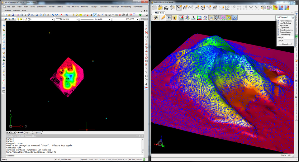
MicroSurvey, the maker of MicroSurvey CAD and the MapScenes System, announces the release of three new software versions optimized to make full use of datasets from the new Leica Nova MS50 MultiStation. MicroSurvey CAD Ultimate 2013, MicroSurvey CAD Studio 2013 and MapScenes PointCloud 2013 provide complete point cloud and Leica Nova MS50 support in an intuitive interface that allows users to quickly and easily integrate 3D point cloud data into their workflows.
Photo: MicroSurvey
MicroSurvey CAD Ultimate 2013, the desktop survey and design software solution for surveyors, contractors and engineers, provides a familiar field-to-finish CAD survey solution with the Leica Nova MS50 MultiStation. With just a few clicks, users can easily import datasets from the Leica Nova MS50 complete with all TPS measurements, pictures, points and scan data. For users who need to enhance their data visualizations with fly-through movies and animations, MicroSurvey CAD Studio 2013 includes all the functionality of MicroSurvey CAD Ultimate plus a powerful animation module capable of creating stunning movies.
MapScenes 2013, drafting, point cloud data visualization and animation tool for forensic investigators, accident scene reconstructionists and other public safety professionals, now includes the ability to take advantage of the rich 3D datasets captured by the Leica Nova MS50 MultiStation. MapScenes 2013 lets the user quickly and easily draw in the point cloud view for extremely fast, accurate linework as well as use the scan data from the Leica Nova MS50 in animations for accurate and compelling reconstructions.
MicroSurvey CAD Ultimate 2013, MicroSurvey CAD Studio 2013 and MapScenes 2013 are available as optional software packages with the Leica Nova MS50 MultiStation. For more information, visit www.microsurvey.com or www.mapscenes.com.
The GPS Fiber Optic Distribution system from Optical Zonu connects up to 32 remote locations, transporting GPS signals from a single antenna to as many as 32 GPS receivers (or multiple antennas to multiple receivers). A common example of this application is a campus scenario where installing multiple GPS antennas is impractical. This particular system consists of the OZC J‐Series 5‐Slot modular 1U chassis. The Master Unit is located within close proximity of the GPS antenna and it contains modular and hot‐swappable fiber optic transmitter, AC power supply and J Optical Splitter cards. The remote unit is a stand‐alone (wall mountable) unit. It comes in a low profile semirugged package. A single 1U chassis at the master site is capable of supporting up to 32 remote locations.
The optical transmitter module has built‐in LNA for high sensitivity detection of low level GPS signals. The Master Unit also has a Bias‐T to provide DC power to the GPS Antenna. Local monitoring is also integrated into the Master Unit, which is accessible via a single computer interface terminal. The maximum RF input signal into the transmitter is ‐25 dBm and the RF interface is via a 50 Ohms SMA connector. The standard optical connector is SC/APC (FC/APC is also available upon request) for low back reflection applications. The system is designed to operate on single mode fiber but may be custom configured to work on multimode fiber. The system is configured for complete dual redundancy, including additional fiber optic Tx module for a second GPS antenna.