Indoor location research and fielded developments currently focus on consumer-level applications, mostly using mobile phone handsets, but this work will hopefully also benefit professional and high-precision uses of GNSS. Indoor location technologies could be of particular interest in machine control for warehousing, industrial assembly, indoor and even underground mapping, underground mining, in forestry where dense canopy virtually cuts out GNSS, construction, and other areas where sky-view is limited or negligible.
Tune in to Indoor Nav Webinar Thursday
Tune in to GPS World’s webinar, “Indoor Positioning and Navigation: Results of the FCC’s CSRIC Bay Area Trials,” on Thursday, April 18. Speakers include Khaled Dessouky (Technocom); Ganesh Pattabiraman (NextNav); Norm Shaw (Polaris Wireless); and Greg Turetzky (CSR). Registration is free.
Professional users will want to keep abreast of developments in the E-911 area, and be aware as achievable accuracies begin to approach what could be possible for precision applications. Right now, that’s maybe a pretty big stretch, but taking a look periodically is a good idea. A recent round of landmark tests by the Federal Communications Commission (FCC) provides just such an occasion for a look-in.
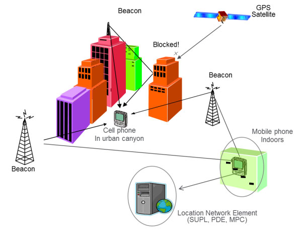
The U.S., E-911 legislation put in place back in 2001 required that both landlines and cellphones should provide the location of callers to within specific accuracy levels. Location information was to be sent transparently to Public Safety Answering Points (PSAPs) which would allow fire/rescue/police personnel to be dispatched to the location of the 911 call. For mobile phones, cellphone manufacturers and network providers forged ahead and implemented a number of location strategies using differing technologies — all require being outdoors where a clear sky-view is available.
GPS and augmented GPS technologies were only part of the cellphone solution. Other implementations included use of the cell-signal itself, along with an extensive database that can contain, amongst other things, signal attributes and network asset locations. Turns out that, today, around 60 percent of mobile phone calls are made within buildings, so the FCC started to investigate how to bring E-911 capability to indoor calls.
In 2011, the FCC commissioned a group called the Communications Security, Reliability and Interoperability Council (CSRIC), and Working Group 3 (WG-3) is the one currently investigating what can be done for indoor E-911 location. Drawn from interested industry participants, the WG-3 Location-Based Services (LBS) sub-group set about finding what technologies exist, how well they work, and how they could be applied to E-911. Now, there are a lot of people trying to crack this problem and many, many ways that it’s been tackled — all of which are at different stages of development and with differing levels of capability. In order to make definitive progress, WG-3 LBS decided that a test-bed was the best way to evaluate and compare what’s currently available.
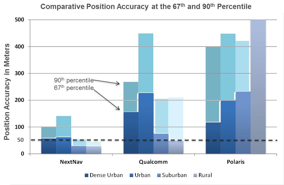
Seven vendors signed up initially, but only three — NextNav, Polaris Wireless, and Qualcomm — completed the rigorous testing, which set out to basically establish horizontal and vertical accuracy, speed of location, and reliability and consistency of results for each system. The trial tested the performance of location systems across urban, suburban and rural areas in the San Francisco Bay Area. More than 13,000 test calls were placed from various tested technologies in 75 different indoor locations selected by participating public safety organizations from around the U.S. Click here for the full report.
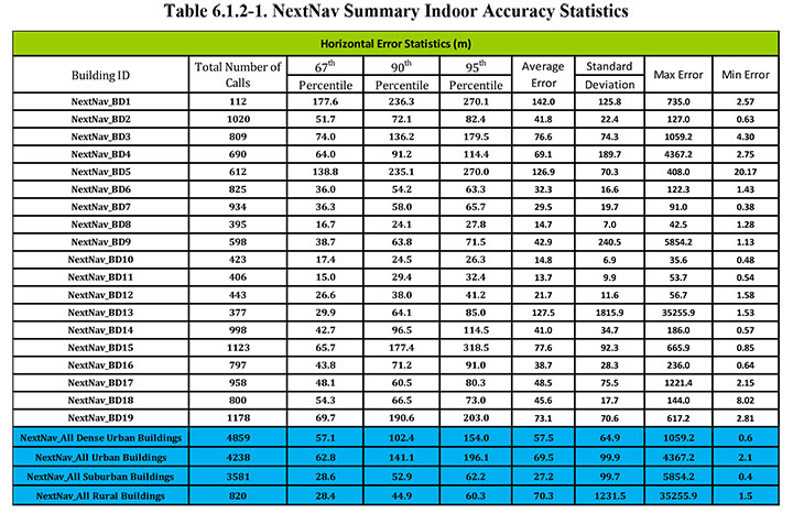
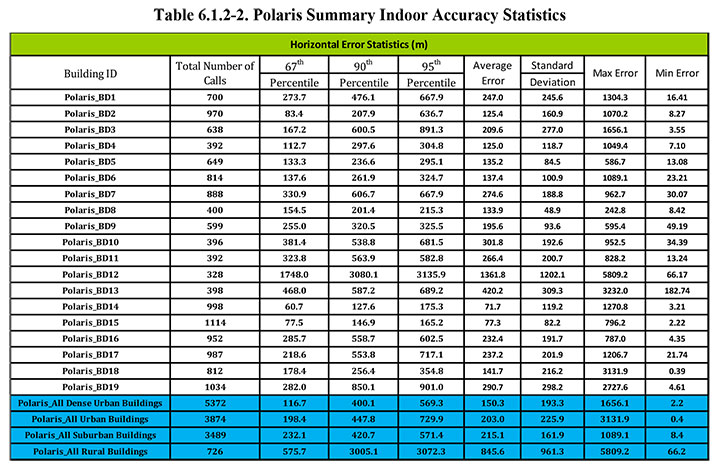
In the tests, Polaris Wireless used an RF pattern matching/fingerprinting technique, Qualcomm used a hybrid Assisted-GPS (A-GPS)/Advanced Forward Link Trilateration (AFLT) system, and NextNav used wireless beacon technology. NextNav came out on top, and largely within the magical 50-meter “search ring” requirement, and was the only vendor to provide vertical location capability.
NextNav uses pressure transducers in its beacons and in the handheld units to accurately measure calibrated altitude — within about 2 meters — so it can actually report the floor where the handheld is located; it’s the only system tested that was able to do so. Apparently the use of MEMS pressure sensors in cellphones is forecast to increase to 681 million units in 2016, so this could be the right approach.
NextNav is focusing on the San Francisco market, where the company has fielded a significant number of beacons, but it has also placed beacons in another 40 metropolitan locations across the U.S. NextNav has acquired appropriate spectrum rights to transmit a 900-MHz “GPS-like” signal that’s synchronized to GPS. This enables good penetration into most urban buildings — both high-rise and those with fewer floors.
To support adoption of its solution, NextNav is working with a chipset manufacturer to incorporate processing of its location signal within an upcoming spin of an embedded cellphone chipset. While other solutions have adopted Wi-Fi and cell-signal solutions, NextNav contends that its approach is the most cost effective, as beacon deployment is geographically less dense and can be amortized over so many users.
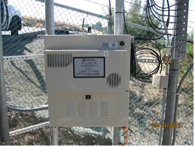
NextNav Beacon.
Other solutions also apparently rely on the use of databases that store signal characteristics and a number of other parameters – the CSRIC report highlights the complexity this brings to database management and maintenance. NextNav also has a database, but this is basically to store records of location, cable configurations and calibration data. This is only used to ensure consistent performance of their system; it’s not required for network operation or location.
Higher precision applications would also benefit from this type of augmentation in the same way that WAAS users achieve higher accuracies, except this system uses local beacons, and there could be the potential for even higher precision with known fixed beacon locations within urban environments. As commercial UAV applications grow, it’s not impossible that there will be higher precision flight applications within cities, for geo-location surveying, building and outside appliance inspections, signal mapping, traffic mapping, road-work repair monitoring — in fact, many of the monitoring activities we see daily in towns and cities where a view of the sky can be particularly restricted.
The CSRIC participants are not the only ones pursuing the holy grail of indoor location. As mentioned, seven different location vendors/technologies began the process to demonstrate their performance indoors through the common test bed, but only three completed the process. The others remain highly motivated and involved, however, and at work tuning their varied solutions. The WG3 report states, “The following location vendors showed initial interest in having their technologies tested and highlighted through the test bed process, but ended up not participating in the Stage 1 test bed, for a variety of reasons.
LEO Iridium Satellite-based Positioning (BoeingBTL).”
Meanwhile, promising indoor location research goes on at a number of commercial and academic institutions, such as the University of Calgary PLAN group, which has focused on integration of Wi-Fi and GPS. An upcoming paper reports that Wi-Fi, using the 802.11 standards, can be employed in several different ways as a complementary positioning technology for GPS/GNSS navigation, and the two can be used in an integrated framework to provide a continuous and robust positioning service.
Another promising component for indoor location could be the recent release of a software application by Baseband Technologies, which can provide rapid ephemeris for up to 28 days, between ephemeris downloads from GPS directly or over cellphones from the Internet. But indoor location warrants much more extensive treatment than these few random comments — what’s summarized here are only some recent developments in E-911.
There will likely be another round of E-911 test-bed activities if funding and management issues are resolved. See CSRIC WG-3 LBS Subgroup member Greg Turetzky’s “Expert Advice” column from GPS World for perspective and a forward look. We can anticipate even wider participation by differing technologies and even greater levels of performance in future. Longer term progression towards higher precision professional applications seems to be inevitable.
The FCC released in March results of intensive indoor location trials of various technology solutions to this most difficult of PNT problems — yet the one that will unlock the greatest remaining untapped potential. The results will shape FCC-mandated position-reporting requirements for cell phones, and will drive future development of all indoor positioning applications. This story gives a top-level view of the results. For in-depth exploration, tune in to the free webinar this Thursday to hear critical information, insight, and perspective on this groundbreaking study from four key participants.
The April 18 webinar is free, but you must register beforehand. A downloadable file of the webinar will be available roughly one week afterwards, in case you miss the live presentation. Speakers include Khaled Dessouky from TechnoCom Corporation, a company that supervised the trials; Ganesh Pattabiraman from NextNav and Norm Shaw from Polaris Wireless, two companies whose technologies underwent rigorous testing in the trials; and Greg Turetzky from CSR, a company closely involved in the process.
Testing Overview
Conducted by the Communications Security, Reliability, and Interoperability Council (CSRIC) of the Federal Communications Commission (FCC), Working Group 3 (WG3), the tests trialled thousands of attempted location fixes in four representative morphologies (dense urban, urban, suburban, rural) and various building types.
The massive R&D movement focus on consumer-level applications, that is, cell phones, but this work will also ultimately affect professional and high-precision uses of GNSS. Those involved in machine control for warehousing, industrial assembly, indoor and even underground mapping, construction both above- and underground, underground mining, utility work, and even forestry will find this of particular interest — any activity in areas where sky-view is limited or negligible.
Today, well more than half of mobile phone calls are made inside buildings. The number of emergency calls roughly parallels that, and both figures are only projected to rise. The FCC has a clear mandate to bring E-911 capability to indoor calls.
The 2001 regulations governing such emergency calls required that both landlines and cellphones should provide the location of callers to within specific accuracy levels. Location information was to be sent transparently to public safety answering points (PSAPs), to dispatch fire/rescue/police personnel to the source the 911 call, and not just to the right street address, but to the right floor of a multi-storied building. That’s the driver for all this.
Widespread application of successful technology/ies meeting the indoor requirement, once determined, is the key to significant revenue for many parties, not least of them GNSS manufacturers and location-based services (LBS) providers.
GPS and augmented GPS technologies were only part of the cellphone solution, and other implementations included use of the cell signal itself along with an extensive database which can contain amongst other things signal attributes and network asset locations.
The WG-3 Locations Based Services (LBS) sub-group set about finding what technologies exist, how well they work and how they could be applied to E-911. Click here for the full report.
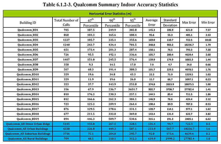
In the tests, Polaris Wireless used an RF pattern-matching/fingerprinting technique, Qualcomm used a hybrid assisted-GPS (A-GPS)/advanced forward link trilateration (AFLT) system, and NextNav used wireless beacon technology.
WG3 selected the San Francisco Bay Area for the Stage-1 Indoor Test Bed. The methodology centered on indoor testing in sample buildings within the most common wireless use environments, called morphologies: dense urban, urban, suburban, and rural.
Dense urban: Bldg. 2: One Front Street, San Francisco, California.Urban: Bldg. 18: Super 8 Motel on O’Farrell St., San Francisco, California.Rural: Bldg. 13: Gilroy Gaits, Beige Stable Building, Hollister, California.
Polygons surrounding areas containing 19 buildings were selected; the distribution of buildings tested was 6 dense urban, 5 urban, 6 suburban and 2 rural. 75 test points were selected by TechnoCom within these 19 buildings. Statistically significant samples of stationary test calls were placed from each test point using multiple test devices for each of the 3 location technologies under test by NextNav, Polaris Wireless, and Qualcomm.
More than 13,000 valid test calls were collected across the test points for each of the three technologies. Broad, representative wireless industry participation in the test bed meant that Polaris’ results were aggregated over AT&T’s and T-Mobile’s networks; Qualcomm’s results were aggregated over Sprint’s and Verizon’s networks; and NextNav operated essentially as a standalone overlay location network.
A certified land surveyor provided indoor ground-truth accuracy to compare test-call locations. The certified accuracy was +/-1 cm horizontal and +/-2 cm vertical.
The test results show the location-performance attributes under test: horizontal location accuracy, vertical accuracy, yield, time to first fix (TTFF), and reported uncertainty.
Satellite signals (in this instance, GPS) have, of course, significant challenges in penetrating large buildings. Consequently, AGPS fall-back modes, such as AFLT, were experienced frequently. Accuracy degraded as expected when GPS fixes were not attained. While a surprising proportion of hybrid fixes were experienced, even at test points where one would not expect a satellite signal to penetrate, the quality of the hybrid fixes was in general significantly degraded compared to GPS fixes.
RF finger-printing experienced its best performance in the dense urban setting. This is probably a combination of a confined environment that could be extensively calibrated and many RF cell sites and handoff boundaries that could be leveraged in creating a good RF fingerprint map of the dense urban center.
The best observed performance in the dense urban setting was that of the dedicated terrestrial (beacon) location system — a new infrastructure. However, due to multipath, location fixes that may be relatively close in absolute distance (for example, 40 meters away) are often located in a building across the street, in a neighboring building, or even across a few blocks from the test point.
Urban Environment
Each individual test building in the urban morphology produced different challenges, and the three technologies under test met them in varying degrees.
A major-league baseball stadium created a situation where AGPS fallback fixes could be very far away due to the exposed RF propagation outside the structure in which the test points were located. Stadium structure created challenges to RF fingerprinting at some test points.
A convention center created in some cases an environment that was deep indoors but with very strong cellular signal from cell sites inside the building. This made the beacon-based location system perform poorer than in most other test points, since attenuation to different directions in the outside world was particularly strong in those scenarios. AGPS and RF fingerprinting relied on the cell sites inside the structure to create adequate location fixes.
An older building of comparatively heavy construction, with a large atrium in its middle, produced widely varying results based on distance from windows or the atrium. Again, the phenomenon of apparent location in a building across the street was seen for both NextNav and Qualcomm. RF fingerprinting fixes appeared to cluster about the larger reflectors in this urban corner of San Francisco, which happened to be mostly across the streets from the target building.
A motel building demonstrated the unique challenge with indoor location: absolute distances (like 50 or 150 meters) which may have meant much in assessing outdoor performance mean less for the indoors, since emergency dispatch to the wrong building or even the wrong block could be easily encountered at those distances. A location across the street is certainly better than one a few or many blocks away but it may still leave some human expectations unmet.
A tall condominium building in a (non-dense) urban downtown San Jose created relatively poor AGPS performance, uneven beacon system performance, and RF fingerprinting performance that degraded with the height of the test point. All of the above factors related to each of the urban buildings, combined with a generally lower cell site density for fall back (than in dense urban), resulted ultimately in an aggregate urban performance that is slightly worse than the dense urban performance.
Suburban Environment
The effect of smaller buildings with lighter construction and more spacing between buildings quickly became evident. Outstanding GPS performance, almost as good as outdoors, can be achieved inside single-story homes. Similarly outstanding performance is achieved on average by the beacon-based location technology under similar circumstances. RF fingerprinting appears to suffer from performance degradation compared to more dense morphologies in the city.
The AGPS performance predictably changes as the suburban buildings become bigger and higher. The terrestrial beacon-based network continues to perform well in the larger suburban. RF finger-printing shows some enhancement relative to the smaller suburban buildings, but still shows most of the location fixes along the roads, highways or reflecting buildings.
Rural Environment
Large one-story structures with metal roofs limited the available number of satellite signals available for trilateration. In these cases more hybrid fixes were experienced with a concomitant increase in the spread of the location fixes about the true location. The performance of the beacon-based network was less impacted by the metallic roof (since that roof had more impact on sky visibility rather than on side visibility towards terrestrial beacons). Consequently the performance was somewhat better than for AGPS. The performance of the beacon-based network would of course depend on the density of its deployed beacons covering the rural area, which was sufficient in the case of the rural test polygon.
RF finger-printing showed reduced performance relative to the suburban environment due to the large spacing between surveyed roads (where calibration is done) and the rural structures as well as the lower density of cell sites.
Conclusion
Finally, the report concludes: “Stage-1 of the test bed contained in the end only three technologies to test. With the complexity of the task at hand, this created a good learning opportunity for both CSRIC WG3 members and the test house. However, there are a number of technologies that are either in use for location based services (LBS) or that are emerging which should be evaluated for their potential to contribute to the improvement of indoor wireless E911.
“Indoor wireless E911 is a critical public safety issue that will only increase.”
One key factor that the report does not at all address is relative cost of implementing these respective solutions. The same can be said for timeline. While some observers have concluded that “NextNav came out on top,” this solution in particular can be presumed to face much greater challenges for full or nationwide implementation than the other two, which rely largely on already existing infrastructures.
Another round of E-911 test-bed activities will ensue once funding and management issues are resolved. See CSRIC WG 3 LBS Subgroup member Greg Turetzky’s “Expert Advice” column from GPS World for perspective and a forward look.
Once again, for an up-close and personal look at the CSRIC Bay Area indoor tests, register beforehand here for Thursday’s webinar, April 18. A downloadable file of the webinar will be available roughly two weeks afterwards, in case you miss the live presentation.
A LocataNet will provide the vitally important high-precision positioning required by the VRC to perform rigorous, consistent and repeatable scientific evaluation of the new vehicle crash avoidance systems, Locata said. VRC crash tests produce the “Top Safety Pick” ratings that have helped consumers make informed decisions about buying safer cars for years. Now research into new technology systems, which allows cars to avoid crashes in the first place, will elevate the value of the institute’s safety ratings, Locata said.
Carrying out these new tests is not a trivial exercise, Locata said. The VRC will have to research and install new robotic and positioning technology to enable the required level of precision. The LocataNet installation will furnish the IIHS with a locally controlled positioning system that is seamless over all of the VRC test areas, enabling extremely reliable automated positioning of vehicles. The newly expanded facility includes a continuous vehicle test track that traverses not only open-air roadway areas, but also a vast 300- by 700-foot fully covered testing area. Locata’s ability to provide centimeter-accurate, locally controlled positioning across both outdoor and indoor environments gives the IIHS flexibility to design a positioning system to meet their vital test requirements, while also allowing easy upgrade and expansion in the future, Locata said.
The dramatic video footage from IIHS crash tests draws extensive media coverage, which becomes a powerful public incentive for automakers to improve the safety of their vehicles. The media, auto industry and policymakers look to the IIHS as a leader in highway safety research, and the expanded VRC will enable the IIHS to play a major role in the emerging area of crash avoidance testing, Locata said. IHS’s YouTube channel shows crash tests and dicusses the ratings system.
“Crash tests and research conducted at the VRC have helped drive life-saving improvements in vehicle designs,” said Adrian Lund, IIHS president. “Our new state-of-the-art facility will allow us to also evaluate emerging vehicle-based systems intended to prevent crashes or lessen their severity, so that we can encourage the entire industry to adopt the most effective ones.”
To do this new research, it is essential to conduct tests under identical, controlled condition, Locata said. With Locata, IIHS researchers will be able to ensure precise positioning data is available in all of its test areas. In places where GPS signals would be unreliable or unavailable when tests are conducted under cover, Locata seamlessly delivers consistent, reliable and accurate positioning, available everywhere, the company said. It will help IIHS carry out automated, identical testing to allow “apples to apples” comparisons of motor vehicles. This is a critical advancement for testing systems that will save many lives in the future, Locata said.
The planned Locata-enabled covered test track.The Locata-enabled covered test track building (artist’s concept).
Here is a video tour of the VRC.
Locata technology provides GPS-style, ground-based positioning covering local areas ranging in size from a parking lot to thousands of square miles. It provides precise positioning either in combination with, or in the total absence of, GPS. It is the first technology that can replicate GPS’s precise positioning capability without using satellites.
Locata’s current devices have already delivered new positioning capabilities to professional applications in mining, aviation, warehousing, and as “GPS backup systems” for important strategic areas. Locata is being trialed by several government bodies in urban areas as a locally controlled positioning infrastructure in applications for transport, first responders, surveyors, and container port automation. As Locata devices are further miniaturized over the next few years, this technology promises to be a game changer for the positioning capabilities available to indoor, mobile and smartphone applications, Locata said.
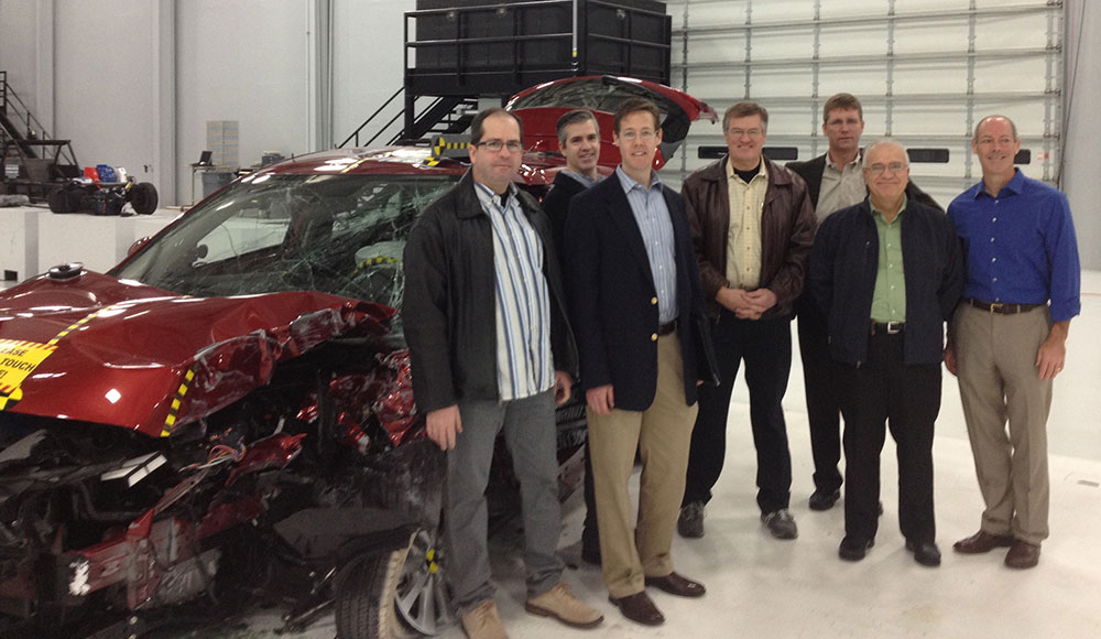
The partners met at the VRC on February 14 to plan out the Locata installation. From left are Robert “Bo” Jones, IIHS engineer; Paul Perrone, president, Perrone Robotics; Geoff Hoekstra, business development, Perrone Robotics; Adrian Lund, president, IIHS; David Zuby, chief research officer, IIHS; Nunzio Gambale, Locata CEO; Jimmy LaMance, Locata. The auto is the result of a crash test conducted that day.
“GPS satellites are in a constant state of motion,” said Nunzio Gambale, CEO of Locata Corporation. “In many environments, this makes it impossible to achieve the level of reliable positioning required for meaningful scientific testing. Locata readily steps into these environments to deliver an always-on, unfailing and superbly accurate positioning signal. We are honored to be chosen as the positioning technology that helps the IHS research, test and drive forward the development of life-saving automotive initiatives. This Locata installation at the legendary Vehicle Research Center will be the most publicly visible jewel in our crown to date. Relationships like this confirm the value of years of hard work we put in to invent this amazing and unique technology.”
“The Locata team is thrilled to see how rapidly our systems are being taken up by the creme-de-la-creme of the positioning industry,” continued Gambale. “We know this VRC testing is world-first, groundbreaking work that has enormous global and social value. It’s wonderful to think that our work may contribute to one day saving my life—or yours.”
The U.S. Department of Transportation’s Research and Innovative Technology Administration (RITA), in partnership with the U.S. Coast Guard, is seeking public comments on current and future user needs for the Nationwide Differential Global Positioning System (NDGPS).
The agencies want to know how users use NDGPS, and are seeking ideas for future uses or alternative uses.
According to the notice in the Federal Register,”The NDGPS was designed to broadcast signals to improve the accuracy and integrity of the Global Positioning System (GPS) derived positions for surface transportation, as well as other civil, commercial, scientific, and homeland security applications. This analysis will be used to support future NDGPS investment decisions by the Department of Homeland Security and the Department of Transportation beyond fiscal year 2016. This notice seeks comments from federal, state, and local agencies, as well as other interested members of the public regarding current and future usage of the NDGPS, the need to retain the NDGPS, the impact if NDGPS signals were not available, alternatives to the NDGPS, and alternative uses for the existing NDGPS infrastructure.”
NDGPS is a ground-based augmentation system that provides increased accuracy and integrity of GPS information to users on U.S. land and waterways. The system consists of the Maritime Differential GPS System operated by the U.S. Coast Guard and an inland component funded by the Department of Transportation. NDGPS is built to international standards, and similar systems have been implemented by 50 countries around the world. Modernization efforts include the High Accuracy NDGPS (HA-NDGPS) system, currently under development, to enhance the performance and provide 10-15 centimeter accuracy with integrity throughout the coverage area. For more information about NDGPS, visit the following webpages:
Comments and related material must reach the Docket Management Facility on or before July 15, 2013.
Comments can be submitted identified by docket number USCG-2013-0054 or RITA-2013-0001 using any one of the following methods:
Federal eRulemaking Portal: http://www.regulations.gov.
Fax: 202-493-2251.
Mail: Docket Management Facility (M-30), U.S. Department of Transportation, West Building Ground Floor, Room W12-140, 1200 New Jersey Avenue SE., Washington, D.C. 20590-0001
Hand delivery: Same as mail address above, between 9 a.m. and 5 p.m., Monday through Friday, except Federal holidays. The telephone number is 202-366-9329.
All comments received will be posted, without change, to http://www.regulations.gov and will include any personal information provided.
Topcon Positioning Group has launched a new web portal—Sitelink3D.net—designed specifically for general construction and engineering companies.
In its announcement at the Munich construction trade show Bauma 2013, Topcon focused on the website’s features, which include giving end-users an intuitive way to manage and control every aspect of Topcon 3D machine control systems anywhere in the world.
The subscription web-based service—accessed via computer, tablet or smartphone—is a user-friendly, real-time visualization and communications tool that allows users to access job site status and create new or update job site parameters, and view movement of machines on the job, Topcon said.
Features of Sitelink3D include file transfers, messaging, machine tracking, remote support and training, real-time cut/fill mapping, and acquiring and storing real-time survey data.
“While Sitelink3D is a complete site communications systems providing data control, machine tracking and a reporting system in one solution, Sitelink3D.net gives complete site management power in real time and provides remote information access to and from any piece of enabled equipment regardless of location,” said Richard Jackson, vice president of machine control applications.
“The web portal provides simple, effective tools for monitoring machine efficiencies and site progress,” Jackson said. Through Sitelink3D.net, “companies can now better manage onsite progress, maintain data integrity, optimize production and minimize downtime. The ability to be able to send and receive job data and make instantaneous decisions or corrections saves time, fuel and money.”
Most machines currently equipped with a Topcon 3D-MC system can be included in the Sitelink3D network by adding the SL-100 radio modem. New Topcon 3D-MC systems can be ordered with the modem pre-installed. Users of Topcon Pocket3D and 3D Office software can also be included in the Sitelink3D network.
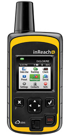
DeLorme has announced the launch of its newest product, the inReach SE (Screen Edition) satellite communication device. With 90 percent of the world’s surface lacking cell phone coverage, inReach SE is designed for the traveler or outdoor adventurer to keep them connected and safe anywhere in the world. The expanded standalone capabilities of inReach SE include a color screen, virtual keyboard, slim design and long-lasting internal lithium battery. In standalone mode, inReach SE provides free-form texting capabilities of up to 160 characters to any cell phone number, email address or social media page.
Using DeLorme’s Earthmate App, inReach SE pairs wirelessly with iPhone, iPad and iPod touch to access topographic maps and NOAA charts and to make text messaging more convenient. inReach SE is also compatible with Android devices.
With the ability to maintain satellite signal lock even in difficult GPS environments, inReach SE also offers global SOS capabilities, adjustable tracking intervals from 10 minutes to four hours, and remote real-time follow-me/find-me tracking and ping-me locating. In the event of an emergency, the interactive SOS capability of inReach automatically triggers remote tracking and allows users to describe and update their situation so proper resources can be deployed, DeLorme said.
“Whether you’re deep in the backwoods, floating on a remote lake, or simply traveling abroad, anyone can benefit from the comprehensive functionality of inReach SE,” said Michael
Heffron, DeLorme CEO. “Over the last two years we have been listening to customer feedback, so the next generation of inReach includes many new features based on their input. The internal rechargeable battery and the on-screen, free-form texting are especially beneficial, making on-the-go communications more convenient and delivering peace of mind to family and friends easier than ever before.”
inReach operates over the Iridium satellite network, providing global two-way satellite communications, high network reliability and low-latency data links (less than 60 second delivery of messages end-to-end) anywhere on Earth, with no gaps, fringe or weak signal areas, DeLorme said.
The follow me / find me tracking feature of inReach provides GPS position updates allowing family and friends to follow the user’s trip as it happens. Family and friends can log into a dedicated MapShare page to follow a detailed breadcrumb trail, ping a location, and send messages to the inReach owner. In the event of an emergency, the built-in SOS button can be activated to trigger a distress alert with delivery confirmation and it automatically activates the remote GPS tracking feature. GPS tracking assists search-and-rescue personnel with homing in on the user’s location, whether stationary or on the move.
Pairing the inReach SE via Bluetooth with the Earthmate App turns a mobile device into a global satellite communicator and navigation tool. Real-time GPS location, tracking and text messages are overlaid on the digital maps for easy navigation and position location. inReach owners get exclusive, unlimited access to DeLorme’s topographic maps and North American NOAA charts, which can be downloaded via an Internet connection prior to departure and remain available in the Earthmate App even when outside cellular coverage.
According to a new research report from the analyst firm Berg Insight, the total value of the global real-time mobile location-based advertising and marketing (LBA) market will grow from €526 million in 2012 at a compound annual growth rate (CAGR) of 65 percent to €6.5 billion in 2017. This will then correspond to 32.8 percent of all mobile advertising and marketing. This means that location-based advertising and marketing will represent around 5 percent of digital advertising, or more than 1 percent of the total global ad spend for all media. SMS, mobile search and coupons are today important high-volume LBA formats.
The ability to precisely target prospective customers using real-time location is currently one of the most promising additions to the advertising toolbox, Berg Insight said. “Key drivers for LBA include the growing adoption of both outdoor and indoor location technologies, as well as the increasing consumer acceptance of location-based services in general,” said Rickard Andersson, Telecom Analyst, Berg Insight. Location targeting in combination with other contextual and behavioral segmentation greatly enhances the relevance of mobile advertising. “Major brands are so far the main spenders, but LBA has also opened the mobile channel for small local merchants. Local businesses can extend their marketing initiatives with mobile components such as location-sensitive coupons using online self-services, while big box retailers leverage enterprise LBA solutions for conquesting and to combat showrooming,” Andersson said.
The LBA value chain is still forming and there are a large number of players involved in the ecosystem, Berg Insight said. Since the value chain is fragmented and the industry has not yet reached maturity, many different roles are involved. Companies range from LBA specialists such as Verve, Placecast and xAd, to LBS players including Telmap, Telenav and Waze, and operators such as AT&T, SFR and the new UK joint venture Weve.
There is, furthermore, an abundance of location-aware applications and media that serve geo-targeted ads, with examples such as Foursquare, Shopkick and SCVNGR. Other stakeholders include coupons and deals providers including Vouchercloud, Yowza!! and COUPIES, search solutions such as Yell and Yelp, and proximity marketing providers like Proxama, NeoMedia and Scanbuy. A number of traditional mobile advertising players are also active in the LBA space, for example Millennial Media, Madvertise and Nexage, as well as major digital and telecom players such as Google, Apple and Facebook.
GIS is a platform for understanding our world. In the past, the data that fueled GIS was typically created to represent the state of the geoscape at a specific moment in time (“historic” or “current”; or “future” to represent a future modeled state). While this data has proven valuable for countless GIS applications and analyses, even the “current” snapshot falls out of sync with the real world quickly. In today’s fast-paced, constantly changing world, the “current” snapshot is outdated almost as soon as it is created.
A number of new technologies are combining to enable the real time collection of data, and the sharing of that data in real time with GIS. The result is a dynamic platform which enables real time visualization, analysis, and understanding of our world. This is the new age of real-time GIS.
Some of the new technologies enabling real-time GIS include:
GeoEvent Processor is a new ArcGIS for Server extension. It gives users the ability to connect to real-time data streams from a wide variety of sensors, perform continuous processing and analysis of those data streams, and send relevant information to users or other systems.
Geofencing is the creation of a virtual perimeter for a real-world geographic area. In the case of GeoEvent Processor, the GIS server is detecting and using geofences to issue an alert when a mobile device approaches, enters, and leaves the geofenced area (which can be based on any map feature). GeoTrigger technology will let developers build geofences into their apps that can be triggered based on time of day, speed, or position. This technology will be available as part of developers’ ArcGIS Online subscriptions in the second quarter of 2013.
GeoEvent Processor for Server makes it possible to use GIS features as geofences and create geofences on the fly Source: Esri
Operations Dashboard for ArcGIS provides a common operating picture for monitoring events. Operations Dashboard integrates maps and a variety of data sources to create comprehensive operational views that can include charts, lists, gauges, and indicators which update automatically as underlying data changes.
Collector for ArcGIS is designed with field crews in mind, and is used to capture and update both tabular and spatial information via smartphones using the built-in GPS capabilities of the device, or by tapping on the map. Data captured using Collector can be displayed in the Operations Dashboard.
Mapping social media data provides insight into what people are saying and where they are saying it. Social Media Mapping apps let you display in real time what people are saying through location-based social media such as Flickr, Twitter, and YouTube.
Esri is also busy adding new features to ArcGIS Online such as Real-Time Data Services, support for GeoRSS Feeds, and more, and we are working with our imagery partners to enable the delivery of Real-Time Imagery in to ArcGIS Online just seconds after it has been captured by satellites.
New types and sources of geographic content, and new ways of sharing them, provide people with exciting new capabilities to incorporate dynamic, real-time information into decision making. The result, as Esri president Jack Dangermond likes to call it, is a Living Atlas of the World—a new vision for the concept of an atlas. “It’s a kind of global gathering place for integrating and applying knowledge about our planet and sharing it with everyone—and to do it all in real time,” says Dangermond.
The thematic information available within this virtual atlas is dynamic; it’s not stored in one centralized, static database—“It’s live, linked to and feeding in from multiple sources across the web and across the world in real time,” adds Dangermond. “The Living Atlas of the World is not only changing the way we look at the world, it is also changing the way we interact with it.”
About Matt Artz
Matt Artz joined Esri in 1989. In his current role as GIS and Science Manager, he helps communicate the value of GIS as a tool for scientific research and understanding. He writes extensively about geospatial technologies, manages the GIS and Science blog, and is the editor of GIS.com. Prior to joining Esri he worked as an Environmental Scientist at a large science and engineering consulting company, on such diverse projects as highway noise modeling, archaeological impact assessment, and chemical weapons disposal. His educational background includes an M.S. degree in Environmental Policy and Planning and a B.S. degree in Anthropology and Geography.
The U.S. Military relies on GPS to aid air, land and sea navigation. Like the GPS units in many automobiles today, a simple receiver and some processing power is all that is needed for accurate navigation. But, what if the GPS satellites suddenly became unavailable due to malfunction, enemy action or simple interference, such as driving into a tunnel? Unavailability of GPS would be inconvenient for drivers on the road, but could be disastrous for military missions. DARPA is working to protect against such a scenario, and an emerging solution is much smaller than the navigation instruments in today’s defense systems.
DARPA researchers at the University of Michigan report that they have made significant progress with a timing and inertial measurement unit (TIMU) that contains everything needed to aid navigation when GPS is temporarily unavailable. The single-chip TIMU prototype contains a six-axis IMU (three gyroscopes and three accelerometers) and integrates a highly-accurate master clock into a single miniature system, smaller than the size of a penny. This chip integrates devices (clocks, gyroscopes and accelerometers), materials and designs from DARPA’s Micro-Technology for Positioning, Navigation and Timing (Micro-PNT) program.
Three pieces of information are needed to navigate between known points A and B with precision: orientation, acceleration and time. This new chip integrates tiny devices that can measure all three simultaneously. The design is accomplished through new fabrication processes in high-quality materials for multi-layered, packaged inertial sensors and a timing unit, in a tiny 10-millimeter-square package. Each of the six microfabricated layers of the TIMU is only 50 microns thick, approximately the thickness of a human hair. Each layer has a different function, akin to floors in a building.
“Both the structural layer of the sensors and the integrated package are made of silica,” said Andrei Shkel, DARPA program manager. “The hardness and the high-performance material properties of silica make it the material of choice for integrating all of these devices into a miniature package. The resulting TIMU is small enough and should be robust enough for applications (when GPS is unavailable or limited for a short period of time) such as personnel tracking, handheld navigation, small diameter munitions and small airborne platforms.”
The goal of the Micro-Technology for Positioning, Navigation and Timing (Micro-PNT) program is to develop technology for self-contained, chip-scale inertial navigation and precision guidance. Other recent breakthroughs from Micro-PNT include new microfabrication methods and materials for inertial sensors.
The radio spectrum is about to get even busier, as Europe’s Galileo satnav system starts services, at the same time the European Space Agency (ESA) tests novel satellite-based telecommunication services. Supporting these developments from the ground, ESA’s new custom-built Telecommunications and Navigation Testbed Vehicle will measure the resulting signals from all over Europe.
Adapted from a Mercedes Benz Sprinter van, this unique measurement vehicle has been delivered to ESTEC by Austria’s Joanneum Research institute. “This is a dual-purpose vehicle, suitable for both telecommunications and navigation system testing,” explained Simon Johns of ESA’s Radionavigation Systems and Techniques Section.
“For navigation, we have the Galileo constellation coming on stream, as well as the stepping up of ESA’s GNSS Evolution programme — designing what comes next after Galileo’s first generation.”
The four wheel-drive vehicle can host a three-person team, and is crammed with dedicated navigation and telecommunication monitoring equipment.
Testbed vehicle screen.
“One of the main goals driving the design was to have an ‘easy to adapt’ test platform suitable to set up test campaigns for different mobile satellite systems and standards that would require different types of antennas and specific receiver/transmit equipment,” explained Olivier Smeyers of ESA’s Communication-TT&C Systems and Techniques Section.
“On the telecommunications side, there is a continuous effort to enhance current and create new mobile satellite-based broadcast and interactive services via the evolution of current systems or developing new standards,” Smeyers said. “Testing in the field is an essential element for validating and eventually establishing evolved or new standards. The vehicle has built-in multimedia equipment, including storage and control computers, multimedia gateway, passenger LCD screens, cameras and microphones, to serve this purpose.”
The vehicle features include two removable roof plates to mount specialized antennas (one currently hosts the antenna of a Broadband Global Area Network satellite terminal for Internet connectivity and multimedia and data streaming), an 8-meter-high telescopic mast capable of carrying 25 kilograms, a rubidium atomic clock synchronized to GPS time with nanosecond accuracy, a high-end spectrum analyzer and oscilloscope for signal measurements, and mobile temperature sensors to monitor the rack equipment.
A fish-eye video camera incorporating onscreen GPS timing and positioning performs continuous recording of its surroundings — to throw light on high buildings, trees, or other factors that might affect results.
Internal and external generators yield up to 5 kilowatts to keep everything running — sufficient power to supply two typical European households.
“The challenge was to fit in all the equipment and provide the necessary power and air conditioning, while still weighing less than 3.5 tonnes,” said Thomas Prechtl of Joanneum Research. “Exceeding this weight would have meant drivers would have needed a special license, and potentially limited its operations in some European nations.”
Neither rain, sleet, snow, hail, wind, nor dark of night will deter…
Loosely Translated, Herodotus, Histories (8.98)
…attendees at the 29th National Space Symposium from their appointed rounds.
Seriously, folks, with apologies to postal workers everywhere, here in the Rocky Mountains it was 72 degrees on the eighth of April, the first day of the largest space symposium in the world. This morning, the ninth, the startled thermometer hovered around eleven degrees with snow, high winds and attendees searching for any outer wear they could find. And except for NASA (National Aeronautics and Space Administration) personnel, everyone braved the weather and soldiered on.
NASA, of course, one of the few government agencies with space in its name, decided they did not need to attend the National Space Symposium this year. But that is NASA’s loss and a story for another time, because more than 9,000 other dedicated space professionals did attend, and more than 170 companies provided major exhibits that filled to capacity the largest pillar-less exhibition hall west of the Mississippi. Just writing this makes my feet hurt. And the best part is this all takes place at the five-star Broadmoor Resort in the foothills of the Rocky Mountains, hence Mother Nature’s raucous spring weather shenanigans.
This is truly a watershed event for the global space community, and it improves every year. I have had the honor of attending 25 of the 29 National Space Symposiums, and as usual there are always a few major topics of interest that everyone wants to discuss. This year I can literally not walk ten feet without someone stopping me to discuss:
The error-plagued GAO (Government Accountability Office) OCX (Next Generation GPS Operational Control System) report and subsequent regrettable sensationalized news reports
The actual status of the OCX program
Lockheed Martin’s GPS III program
NavSat – Nee Parkinson’s NibbleSat – real or imagined
Software-defined GPS receivers and GPS user equipment in general
When it comes to opinions, informed or otherwise, concerning each of these topics, the resulting litany reminds me of the old saw about asking three psychologists to comment on a patient’s diagnosis, and you will invariably wind up with four opinions. But have no fear: I spoke directly with the prime companies developing each of these programs, and the following is straight from the horse’s mouth, or some other part of their anatomy as the case may be. You be the judge.
GAO and OCX
The Government Accountability Office, which historically is anything but, released a report on March 28titled “Defense Acquisitions: Assessments of Selected Weapon Programs,” in which it seems to claim that the original $886 million GPS OCX program awarded to Raytheon Information Systems in Aurora, Colorado, in February 2010, has grown by 43 percent and ballooned to $3.695 billion. In fact, the report does not actually say that exactly, but you have to dig deep to determine that. Most readers won’t take the time to do that and will assume that the OCX program is grossly over budget. It is not. In fact, to reach that extraordinary number, OCX cost overruns would need to have grown by 43 percent for each year since it was awarded, and that is ludicrous. According to Raytheon VP and OCX Program Manager Ray Kolibaba, the $3.695 billion number probably comes from including “…programmatic costs beyond OCX development costs and pessimistic projections from the government” that in my experience no acquisition agency, nor Congress for that matter, would ever include when determining true program cost adherence parameters. Such ancillary costs would certainly never be included in a Nunn-McCurdy-Sarbanes-Oxley-Graham-Rudman-Harry Potter fiscal responsibility evaluation.
Speaking from personal experience, in 1990 I was appointed the very first Legislative Liaison Director for Headquarters Air Force Space Command. I had a small office and staff and spent most of my time on Capitol Hill meeting with congressmen and senators, where I advocated the latest space programs, and/or sat in on congressional hearings and then advised senior U.S. Air Force space officials on what budget and policy decisions they could expect from Congress. And I can tell you now, using the methods the GAO concocted to compile this report, I could cause any space program to come under close and unwarranted scrutiny. However, using time-tested congressional oversight rules of engagement (ROE), OCX has not come close to triggering any of the automated congressional watchdog cost overrun tripwires. The truth of the matter is OCX has grown in scope and schedule due in part to government change requests, mainly in the cyber and information assurance areas, along with affordability mandates due to schedule slips and sequestration. According to Stephen Moran, Raytheon mission solutions director, the true cost of OCX today is approximately $967 million, which means the total program cost to date has grown by approximately 10 percent, a far cry from the fictitious annualized 43 percent increase claimed by the GAO. While the GAO goes to great lengths to justify its inflated numbers, it is comparing or rather sensationalizing apples and oranges.
Some may say, so what? Who outside of Washington D.C. reads or believes GAO reports? Unfortunately, Congress, the congressional staff and congressional budgeters read these reports, since the GAO is officially the investigative arm of Congress. In fact the GAO is an independent, nonpartisan agency that works for Congress. Often called the “congressional watchdog,” GAO investigates how the federal government spends taxpayer dollars. And many times they do a great job. But in this case they are wide of the mark. It would be a shame if Congress cancelled OCX because of a flawed or, at a minimum, a poorly explained report.
Ray Kolibaba and Stephen Moran assured me during our talks at the 29th NSS that OCX was alive and well and on track to meet a re-baselined time and costs schedule. OCX Block One RTO should occur as planned in the first quarter of 2017 and will include the ability to launch and control GPS IIF and GPS III satellites and payloads, but not GPS IIA satellites and payloads. That mission, along with the responsibility for maintaining residual satellites, still falls to the LADO (Launch Anomaly and Disposal Operations) contractor Braxton Technologies, which is an OCX subcontractor to Raytheon.
The bottom line is the OCX schedule has slipped and the budget has grown, but within historically acceptable parameters; certainly, it is not even close to triggering congressional oversight. However, having said that, in this budget sequestration environment, the overall GPS budget has taken some significant hits so that even the slightest cost overrun is of concern. Still, let’s hope that Congress makes funding decisions using actual historically acceptable numbers and not overblown rhetoric.
LMCO and GPS III
Keoki Jackson
Let me say right up front that I really like Keoki Jackson and what he has accomplished on the GPS III program at Lockheed Martin. Keoki is the vice president of Navigation Systems, and as such heads the GPS III program. Keoki has an honest and open demeanor and just oozes integrity. He runs a very open program and, indeed, has extended an open invitation to me, wearing multiple hats, to visit the LMCO GPS III facility in Waterton, Colorado, to discuss GPS III anytime. Believe me, I have and will continue to take him up on his offer. To someone in my line of work, that confidence speaks volumes. Keoki obviously has supreme faith in his people, and is assured the GPS III program is on the path to success. I spoke with Keoki on Monday, April 8, as I toured the GPS III facility with him. He was like a father with pictures of his children. Happy, smiling, engaging — he could not wait to show off their latest accomplishments.
My bottom line is this is a rare attitude among senior execs and PMs on major space programs. And that may be because so many of them are under congressional scrutiny. Not the case for GPS III, however. The back-to-basics GPS III program is on schedule and budget, and is set to deliver GPS III SV-01in May 2014, exactly six years after program award. The USAF has said it may not launch the first GPS III until April 2015, but that is a separate ground support and commanding issue. It has nothing to do with the schedule and availability of the GPS III satellites.
Historically, LMCO-built satellites are some of the best in the world. According to LMCO statistics, and verified by yours truly, LMCO GPS satellite vehicles have accumulated more than 175 operational years on orbit with a reliability record better than 99.9 percent. Keoki also proudly pointed out that the Lockheed Martin heritage dates back to the production of the Oscar and Nova Transit satellites — programs that paved the way for the current GPS gold standard on orbit today.
Now, don’t let the back-to-basics approach fool you. That just means sound, solid, proven engineering and management practices are employed, but the technology is anything but basic. The kingpin of the LMCO GPS III approach is an artifact known as the GNST, or pathfinder spacecraft. The GPS III Non Flight Satellite Testbed (GNST) gives everyone confidence that Lockheed is on the right track. The pathfinder goes through all the rigorous steps a flight article goes through, only it completes them first and allows LMCO personnel to find all those schedule-busting, expensive glitches that show up in any program. As Keoki said, “Our endeavor is to find any anomalies now before the satellites and payloads are on orbit.” The GNST, along with cutting-edge 3-D motion studies with avatars (an amazing story and teaser for another time), will hopefully allow a smooth transition for SV-01 through SV-09 when the program plans to initiate programmatic and hardware changes to allow for the first-ever GPS dual launch.
This is a far different approach from the Boeing GPS IIF spacecraft and payloads, which experienced major anomalies on orbit for the first two SVs. Changes were made to subsequent ground space vehicles before launch, but the first two SVs on orbit are stuck with those anomalies. The LMCO approach hopes to eliminate or at least minimize that risk. If the full LMCO GPS III program comes to fruition, there could eventually be as many as 32 GPS III satellites in various configurations on orbit. Which means Keoki will probably be referring to GPS IIIs not as children but grandchildren, and he will need a much bigger scrapbook. Bottom line, GPS III is alive and well, on schedule and budget.
NavSat or NibbleSat
For those of you who have not heard about the NavSat or NibbleSat, it is a small GPS satellite endeavor by AFSPC, SMC, and AFRL to determine the feasibility of building a GPS-only small satellite, one without NDS, SAR, or any other auxiliary payloads. However, this is not solely a Weight Watchers program — it is about far more than a slimmed-down GPS. It addresses technological aspects of the GPS program as well as SWAP (size, weight, and power) issues that have plagued the GPS program since its inception.
Since 1978 when the very first GPS satellite was launched, the program has grown in complexity and size with ancillary payloads, more signals, more power, and more flexibility, which all add up to a heavier, more complex satellite — and in space, where weight and complexity equal greater costs. GPS III has finally reached the point that it will cost nearly $450 million to place a single GPS SV and payload in orbit.
As I said earlier, the GPS III payload may last 30 years, which equates to a sizeable return on your investment (ROE) for space assets, but in this constrained sequestration budget environment Congress is not looking down the road 30 years; it is barely able to consider the FYDP or the next five years’ development plan budget. So $450 million per GPS III on orbit is a big number. Even with dual launch, according to Lockheed’s Keoki Jackson (see above, “LMCO and GPS III”), from SV-09 forward the savings will only amount to about $70M per launch because it will require a larger launch vehicle. Certainly, $70 million is not a number to disregard, especially if you could build and launch a small GPS-only SV for that same amount. I know it sounds nearly impossible, but that is what the NavSat program hopes to achieve. To date, no less than 20 companies, U.S. and European, have expressed an interest in making NavSat happen. Most companies I spoke with are convinced it is not a technological issue, but a commitment and funding issue on behalf of the U.S. government. So what else is new? In my book, NavSat is a real possibility, and the recent plethora of BAAs (Broad Area Announcements) from SMC (Space and Missile Systems Center), AFRL (Air Force Research Laboratory), and SPAWAR (Space and Naval Warfare Systems Command) attest to that fact. Stay tuned for more.
GPS Payloads, Receivers: Software-Defined and Otherwise
It is a fact of life where GPS is concerned that when you talk about GPS technology, you are talking about ITT Exelis. There is not a single U.S. GPS payload on orbit today that was not built in whole or in part by ITT Exelis. There are few companies in the world today that can claim such a prestigious record for space assets that are arguable the best in the world. The ITT Exelis record of providing proven GPS payloads for 35 years is unequaled in the space arena, and the company continues to innovate and grow. So, it should come as no surprise that Exelis provided LMCO with the GPS payload for the GNST pathfinder mentioned earlier. The bottom line is, when it comes to GPS payloads, nobody does it better than ITT Exelis.
Therefore, I took the opportunity to sit down with Mark Pisani, a vice president and general manager in the geospatial systems business at ITT Exelis, to discuss the recent $2.15 million contract award from AFRL to research navigation payloads to support the current GPS program and the NavSat program specifically. Mark stated that the technologies being investigated could easily translate to the entire GPS program.
Mr. Pisani stated that over the next 18 months, the company will conduct research into potential methods to reduce payload size, weight, and power, and improve GPS signal strength and reception for disadvantaged users, especially warfighters, in either urban canyons or mountainous terrain. ITT Exelis is also working on new methods of tamper-proofing for its GPS reference and monitor receivers, which will deployed around the globe to ensure GPS accuracy for all global users. So it appears that where GPS is concerned, you name it and ITT Exelis is working some aspect of the program.
NSS Wrap-up
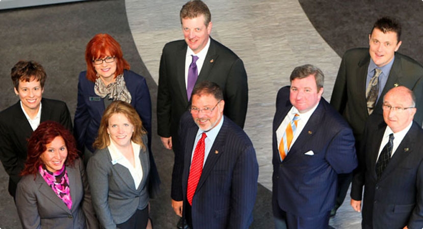
Space Foundation Leadership Team.
NSS 29 is still in full swing as I write this. Indeed, my old friend and colleague in uniform, General William (Willie) Shelton, just gave his state-of-the-military-space-community address, and he did it in his usual exemplary manner. Few generals can match his grace and style. But to paraphrase Robert Frost, “…deadlines, time and tides wait for no man,” so I will wrap up with a few personal observations.
As many of you have heard me say, year after year, the National Space Symposium is like no other space event in the world. It gets bigger and better every year, and this year events extended all the way to LMCO in Denver and to Broadmoor properties that have never been used for this event previously. The NSS agenda and speakers are top notch and international in nature. Just a sampling are George Nield, associate administrator for commercial space transportation at the Federal Aviation Administration (FAA), Jean-Jacques Dordain, director general of the European Space Agency (ESA), and Yasushi Horikawa, chairman of the United Nations Committee on the Peaceful Uses of Outer Space. Officials from commercial space leaders such as LMCO, SpaceX, Boeing, XCOR Aerospace, Sierra Nevada Space Systems, and others will also speak, while actress Sigourney Weaver, star of the Alien films among others, is the featured speaker at the Space Technology Hall of Fame gala tomorrow night. So there is literally something for everyone.
Sigourney Weaver
I have known Elliot Holokauahi (yes, it is a mouthful) Pulham (CEO), Chief Chuck Zimkas (USAF, Ret) who serves as president of the Space Foundation, and Holly Roberts, the CFO, for many, many years, and they are always striving to make the National Space Symposium better every year; in my book, they have succeeded beyond anyone’s wildest dreams. Their zeal is combined with the dedicated support of Steve Bartolin, CEO and president of the Broadmoor. I first met Steve more than 25 years ago when he ran the famed Greenbriar Resort in White Sulphir Springs, West Virginia, the playground of congressmen and senators. Steve has always had a penchant for living in places that ended in Springs, as well as for perfect service, while going to great lengths to make sure his employees are happy and enjoy their work. It shows at the Broadmoor, which is a Triple AAA Five Diamond Resort, and has been for more than 20 years. Together, Steve’s commitment to perfection and the vision of the Space Foundation make the National Space Symposium not only the world’s largest but by far the best space symposium in the world today.
Braxton Technologies Sets the Example
Personally, I enjoy the exhibit hall and tend to spend most of my time there. The event along with the Cyber presentations lasts for four full days, but you cannot see and do everything in that time, which leads me a personal observation. Many of the vendors and exhibitors in the past several years have begun to offer refreshments in their booth space, to help draw in the huge crowds always roaming the exhibition floor. Some offer ice cream, coffee, even beer and pretzels, but personally I like what Braxton Technologies has developed. Remember, this is a Space Symposium, so Braxton decided to mount small-scale full working models of various satellites above their booth space and allow attendees to actually send wireless commands to control the satellites. You can sit at one of their control stations, see a real spacecraft commanding (TT&C) screen, send commands to the scale-model satellites, and watch the satellites react in real time.
Now, Fred (I call him the model builder and engineer extraordinaire) is the one who built the majority of the models, and they are an excellent example of fine craftsmanship. Indeed, the first night there were some issues with one of the older models, and Fred stayed in the booth working the problem from closing time on Monday evening until 0700 on Tuesday morning. And his hard work paid off, because there is always a crowd around the Braxton booth waiting to control or just watch the satellites respond. The Braxton folks are very good at and very proud of what they do, and it shows. They automated GPS scheduling, on their own nickel last year, and this year offer a glimpse at the future of GPS mission planning. Plus, they have an application for unimproved aircraft landing sites around the world that is simply amazing.
But, in the end it is watching the children, the future space operators and astronauts, who gather in huge crowds around the Braxton booth, waiting with thinly veiled anticipation to send a command to a satellite. It has been a long time since I was a child, but you should have seen the smile on my face when Fred allowed me to send a command and I could see the satellite model respond. Both Frank Backes, Braxton CEO, and Kenny O’Neil, Braxton president, and most of the Braxton employees are former space operators, and they have not forgotten the thrill of actually commanding satellites. Now they have made that thrill available for our future space operators. I think they hit it out of the park.
There’s still time. Drop by the Braxton booth, speak with Fred, and send a command to a satellite. Oh, and you are allowed to smile!
Until next time, happy navigating, and go fly a satellite!
GreenRoad has announced the integration and availability of GreenRoad Advanced Tracking, powered by GPS Insight fleet tracking service. GreenRoad Advanced Tracking provides fleet operators with a new level of insight into fleet performance, resulting in improved fuel economy, better asset utilization, and enhanced productivity, GreenRoad said.
With the availability of GreenRoad Advanced Tracking, GreenRoad adds powerful fleet management capabilities to its best-in-class driver performance and safety solution, which combines real-time, in-vehicle safety feedback with a management portal that provides insight and guidance.
“GreenRoad Advanced Tracking builds on the GreenRoad Connected Fleet vision by giving managers deeper, broader insight into how they’re using their fleet assets, in addition to how their drivers are performing,” said Karen White, senior vice president of customer solutions for GreenRoad.
Additional highlights of GreenRoad Advanced Tracking include:
Interactive displays of entire fleet, any vehicle group or single vehicle. Color-coding for easy status identification, 2D and 3D mapping, vehicle history trails, automatic alerts when management attention needed.
Increased fleet activity insight with landmark and geofence support. Automatic alerts when a vehicle enters or leaves a landmark or group of landmarks.
Enhanced reporting to optimize fleet resources. Multiple, detailed activity reports including Drive Time Summary, Fleet Utilization and Odd-Hours Violations. Vehicle MPG reports available with fuel card transaction data integration.
A customizable dashboard runs specific reports and provides managerial insights with a minimum of mouse clicks.


.")