National Geographic Mapshas joined with Avenza Systems to offer a new channel to access its map content. The alliance enhances Avenza’s digital map database by adding more than 500 maps from National Geographic and furthers National Geographic Maps’ established reach with mobile consumers.
The Avenza PDF Maps app takes advantage of geospatial technology and allows users to view, acquire and interact with maps on their mobile devices, including iPhone and iPad, without needing a mobile data connection or being accessed international roaming charges. PDF Maps offers an in-app store to facilitate the transaction and delivery of the maps, consolidating, in a digital format, consumers’ access to hundreds of maps from multiple publishers.
“In the last decade, advances in technology have shifted how consumers receive and use information, and we have responded by making our rich map content available on a variety of platforms,” said Charles Regan of National Geographic Maps. “Avenza’s PDF Maps app provides a unique way for consumers to access our content with an easy-to-use in-app map store and a set of robust features that will enhance the map user’s experience.”
Hundreds of maps from National Geographic Maps’ extensive library are now available in Avenza’s PDF Maps system, including travel and destination titles covering five continents, historical and thematic maps, and educational and reference titles. The app provides constant access to geographic information and points of interest, with additional interactive tools such as measuring, place marking and location tagging. PDF Maps operates without the risk of lost reception, due to cell tower proximity, and does not rely on an Internet connection.
Broadcom Corporation has introduced the BCM47521, a GNSS chip with architecture that enables geofence capabilities while preserving battery life. According to Broadcom, the new chip opens the door to always-on location-aware applications such as social networking, place-based mobile commerce and local merchant advertising.
Broadcom will showcase its GNSS innovations at the upcoming Mobile World Congress show in Barcelona, February 25-28.
A geographical region of interest (“geofence”) is being used by many new and innovative location-aware applications. The geofence feature enables the application to receive a notification when a user enters or exits a virtual perimeter. However, the implementation of this feature in traditional architectures is not viable, as the applications processor needs to run constantly, causing rapid drain to the device’s battery. Broadcom’s new BCM47521 overcomes this issue, making it possible to continuously monitor geofence areas while consuming 60x less battery power.
“The astounding growth of mobile devices is driving new opportunities for inventive applications that deliver valuable location-aware information,” said Scott Pomerantz, Broadcom vice president and general manager, GPS. “With the BCM47521’s low-power geofence mode, Broadcom is driving the next wave of system power consumption innovation that will allow OEMs to incorporate features that differentiate their mobile offerings and make location-aware, always-on applications a reality.”
The BCM47521 chip also provides multi-constellation support by simultaneously collecting data from GPS, GLONASS, QZSS and SBAS, and using the best received signals, resulting in faster searches and more accurate real-time navigation, Broadcom said. Broadcom’s multi-constellation technology, coupled with advanced signal processing, provides faster positioning performance for improved user experience, especially in challenging urban environments where buildings and obstructions can dramatically impact accuracy and time-to-first-fix.
A key feature is the 60x better system power efficiency versus a host-based architecture. An advanced host-offload mode monitors geofences in the background and only activates the applications processor when there is a trigger event, and smart algorithms adapt in real-time as the user gets closer to a geofence boundary.
LOCiMOBILE, Inc., a wholly owned subsidiary of GTX Corp, has launched its first enterprise app for companies looking to effectively track and monitor their workforce in real time. Track My Work Force (“TMWF”) is available for download on iTunes, and based on its early success, is in development for release on the Android platform.
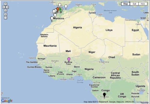
Once downloaded on either an iPhone or iPad, the app works in the background and reports the whereabouts of that device back to the GTX Corp monitoring back-end. The app was designed for small- to medium-sized companies that have a mobile sales or service workforce and need to know the location of their reps in real time. Companies in the U.S., Canada, Czech Republic and Morocco, in industries including transportation, construction, plumbing, IT, medical and pharmaceutical, have already deployed the TMWF app and the GTX back-end monitoring platform.
In January, a pharmaceutical company based out of Morocco that services 25,000 pharmacies across several North African countries deployed TMWF for 150 of its sales reps.
“Our diamond delivery business relies heavily on our traveling sales representatives in order to maintain relations with existing customers as well as meeting new ones. GTX Corp’s Track My Work Force app was extensively tested during our system trial,” Jack Daynes of the Diamond Group said. “The results were such that we implemented the program immediately and haven’t regretted it in the slightest. Both the pricing and the service that we’ve received have exceeded our expectations.”
Companies can easily deploy this technology by leveraging the mass adoption of smartphones and tablets in the workforce, said GTX Corp. In January, a pharmaceutical company based out of Morocco that services 25,000 pharmacies across several North African countries deployed the app for 150 of its sales reps.
“We are very pleased with the initial feedback and potential of this app,” said Patrick Bertagna, GTX Corp CEO. “There are tens of thousands of companies all over the world that can benefit and increase customer service, productivity and security from two-way GPS technology and are now able to implement this technology with a simple download.”
The TMWF app is an efficient and cost-effective way for business owners and managers to keep track of and manage their mobile work force, GTX Corp said. It’s faster and safer than text messaging and allows the worker to focus on the task at hand rather than spending valuable time calling HQ to check in and report, the company said. The app costs $9.99 initially, with an additional monthly monitoring service fee that costs around $5.00 per user per month.
The company provides a free two-week evaluation for any business with more than five employees, and custom solutions along with a licensable white-label platform for larger companies.
Trimble has acquired a suite of software solutions from Penmap.com Ltd. of Bradford, United Kingdom. Penmap.com’s solutions include both office and field data collection software specifically designed for the cadastral and surveying markets. The comprehensive software suite enables Trimble to further address local application requirements and customer needs by providing complete customized surveying software solutions for the cadastral market, the company said. Financial terms were not disclosed.
The software solutions include:
Penmap encore: A new solution specifically designed for PDAs and handheld GPS receivers running Windows Mobile operating system. The software’s revolutionary user-friendly interface takes advantage of virtually the entire display screen to maximize map real-estate and is designed for fingertip operation.
Penmap encoreT: A new premium data collection software specifically designed for tablet PCs running Windows 8, 7, Vista or XP operating system. Its user interface shows collected data on the map in real-time. This feature gives users peace of mind that they have collected data correctly before leaving the site, Trimble said.
Penmap Office: An intuitive office platform for Penmap encore software. The office software streamlines the land administration professional’s workflow — from project preparation and importing data to managing large raster and vector background maps collected in the field, Trimble said.
“Penmap.com has built a very close and successful relationship as a customer of Trimble for many years,” said Erik Schütz, managing director for Penmap.com Ltd. “Since Penmap.com was founded, our vision has been to focus on the local requirements of the regional markets we serve and provide those customers with a fine-tuned and easy-to-use solution. The software is an ideal fit within the Trimble portfolio of solutions to address the cadastral market.”
“The acquisition of Penmap.com’s software suite of office and field solutions reinforces Trimble’s continued commitment to the cadastral market, as well as our focus on providing customers with complete solutions that are customized for local market requirements,” said Matt Delano, business area director for Trimble’s Land Administration Solutions. “Penmap.com’s strength lies in its ability to customize surveying software applications for regional markets, providing users the most intuitive work processes for optimal efficiency and productivity, making it a perfect fit for our customers.”
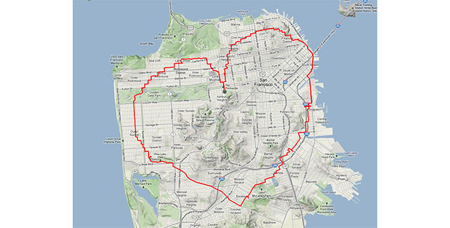
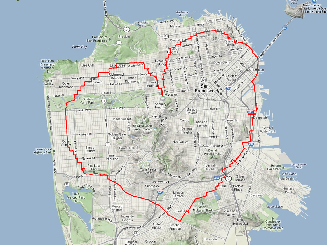
Yes, there is a way. According to Krulwich Wonders, an NPR science blog, a man in San Francisco equipped with an iPhone and tracking app rode his bike 27 miles around the city. Two and a half hours later, Payam Rajabi had etched a heart shape onto a city map.
Click to enlarge.
In 2012, Rajabi had to leave his girlfriend behind in Toronto for a new job. To make sure Clare knew this was a labor of love, Payam included an elevation map of his ups and down in the hilly city.
This year, Verizon is featuring Rajabi — who repeated the feat for cameras — in a television commercial:
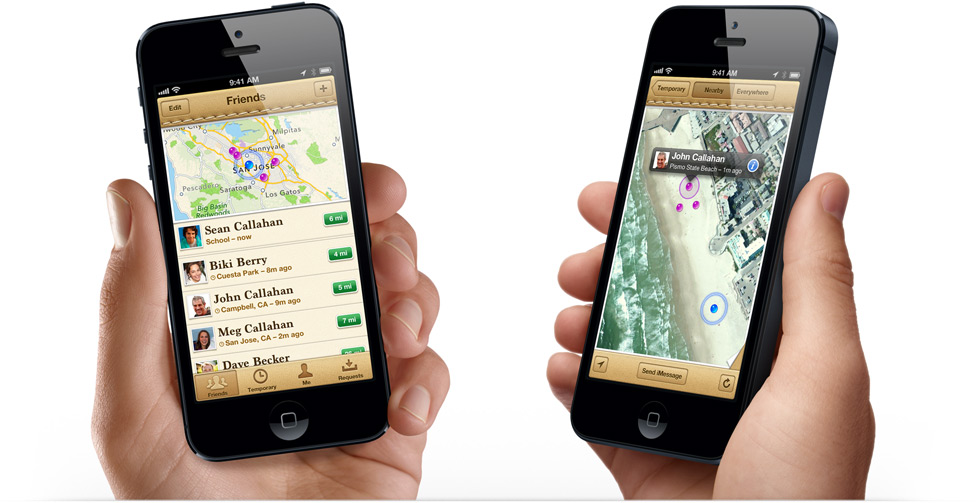
There always is a lull in news between the Consumer Electronics Show and the Mobile World Congress, which is later this month in Barcelona. However, published reports that Facebook plans to launch a location application is big news. The social network giant, with more than 1 billion mobile users worldwide, could conceivably generate huge advertising revenue through the location-based friend-finder app. Facebook has a number of competitors, but with the sheer number of worldwide users, it has to make the industry take strong notice.
Facebook to Roll Out Location Application for Mobile Users
Facebook is attempting to grab a big piece of the mobile location market with a new app that will track users to perhaps boost mobile advertising sales. The news, first reported by Bloomberg, indicates that Facebook is adding location features to perhaps take a chunk of profit from 1 billion mobile users who use the social network.
The new feature, expected to be launched in March, will work with smartphones, even when the user is not using the application, according to the Bloomberg article. This may raise some privacy hackles, as competing services have opt-in functions. In addition, some handset manufacturers and carriers require user opt-in as part of privacy agreements.
Facebook already purchased two location companies in Glancee and Gowalla. Glancee is a location-tracking startup Facebook bought in May 2012. Gowalla, a location-based social network, was purchased in December 2011.
Facebook Has Competitors in Location Market
The new Facebook location app will be an answer to Google Latitude, which was launched in early 2009. Latitude, a feature for Google Maps, is an opt-in mobile app that allows users to see the location of friends and family, who also allow the service to track them. Google’s premise, four years ago when it launched Latitude, was that many users wonder where their friends and family are — and what they are doing.
Because it is an opt-in service, Google said users could find out where a spouse was stuck in traffic on the way home from work, knowing when a loved one’s flight landed safely, or if a buddy was in town. Although it has been around for more than four years, Latitude was innovative with the concept that not only can you see friends on a map, but you can get in touch with them via SMS, Google Talk, gmail and updating a status message.
“While Google quietly improved its databases, tools and location services, most other players in the location industry were slipping further behind, apparently involved in a frenzy of disorganization prompted by a lack of skills in strategic planning,” said Mike Dobson, Telemapics president, in a recent interview.
Another similar service, Find My Friends from Apple, runs on the iOS 5 operating system. It is another location share service that attempts to allow users to find friends in real time, according to published reports.
Apple needs to hit a home run in the location and mapping market. Last year, the controversy surrounding Apple Maps caused a shake up at the company and industry because of faulty map data. The incident made manufacturers realize that digital maps are a very important feature for smartphones. It also made many of these giant companies, who believe that location isn’t that big of a deal, sober up to the fact it is hard to make quality maps.
A number of other companies are offering friend and family finder apps, namely Location Labs, Life360 and Loopt.
Still, while such companies as Facebook, Apple and Google give away maps and navigation for free, which destroyed smaller companies and caused a huge consolidation of the industry starting in 2008, some believe that maps are too hard to produce for free. Some analysts, Dobson included, think that “free” maps and navigation services may not stay that way as consumers and enterprise customers demand better accuracy.
Tablet Owners Spend More than Smartphone Buyers
In advance of the Consumer Electronics Show, analysts were saying not only that flatscreen TVs sales were dropping, but the champion of the previous shows, the tablet, also was to see a downward trend. Not so, says ABI Research, which estimates nearly 200 million tablets shipped worldwide since 2009, with an additional 1 billion tablets forecast to ship over the next 5 years.
What’s interesting, or not, depending on your location company’s strategy, is that ABI says 22 percent of users spend $50 or more per month and 9 percent spend $100 or more on purchases ordered from their tablets. That’s higher amounts than from even smartphones, the company says.
As we reported last fall, the next edition of Amazon’s Kindle Fire tablet introduced mapping services in partnership with Nokia, which snubbed technology from Google, which is funny because its mobile operating system powers the platform. But it was an indicator of how much promise companies are still seeing in adding location-based services capability to tablets.
In other LBS news:
Sense Networks released the results of a location-based mobile advertising campaign for Denver-based fast food chain Quiznos. The campaign, conducted in Portland, Oregon, placed ads on mobile devices of people 18-34, who eat at competing, and similar, restaurants such as Subway. The company said Quiznos had a 20 percent gain in coupon redemptions.
TeleCommunication Systems, Inc. (TCS) is providing map, local search, location services and navigation applications for the new BlackBerry 10 smartphone. The TCS-based mapping application will ship with the new smartphones, which are scheduled to roll out in mid-March. TCS’ APIs are also available for Blackberry 10 developers. This leads many in the industry to believe that if this smartphone is a much-needed home run for Research in Motion, the TCS partnership could be a big deal.
Locaid plans to provide GTECH with secure mobile location, IP location and other LBS to include geofencing and location authentication. What’s cool about this deal is GTECH designs and sells lottery technology. Its service includes a geo-complaince engine that ensures a mobile or Internet-connected device is within state lines.
If you have news, or tips, or gossip, please contact me at [email protected]. The Mobile World Congress in Barcelona is coming up this month, so get me your story ideas and product news.
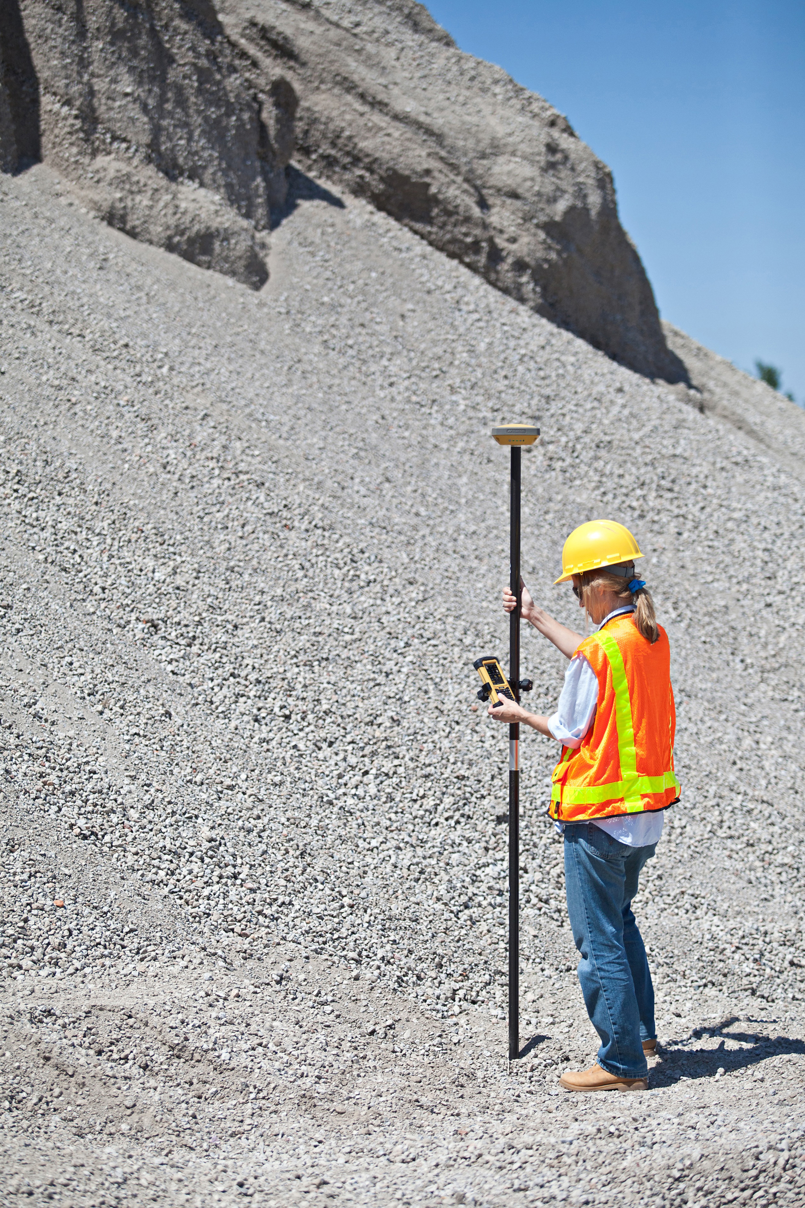
With the introduction of a new version of Pocket 3D software for its HiPer SR GNSS receiver, Topcon Positioning Systems is expanding the delivery of high-accuracy 3D positioning technology to contractors needing a low-cost, one-man layout and measurement system.
Pocket 3D is powerful, easy-to-use data collection and control software for grade checking and other measurement applications on a job site. Version 10.0.2 makes it fully functional with the HiPer SR receiver, introduced in August.
The new receiver is not only “perfect for contractors, but also for other non-traditional GNSS users such as landscape architects, law enforcement forensics projects or any others requiring high-accuracy 3D positioning,” said Tony Vanneman, Topcon construction products marketing manager.
Its field-rugged and fully-integrated design delivers a 1,000-foot working radius through Topcon’s new LongLink technology. “This innovative wireless data link was developed specifically for the HiPer SR, and provides reliable and interference-free base-to-rover communications that don’t require an FCC license to operate,” Vanneman said.
“We took the best signal tracking technologies and packaged them in a small, energy-efficient design,” he said. “Anyone looking for a rugged, easy-to-use, low-cost 3D GPS system will find what they need in the HiPer SR.”
Additional key features of the HiPer SR include:
Shock-resistant magnesium alloy housing – allowing the HiPer SR to take a 6 ft. (2m) pole drop onto concrete;
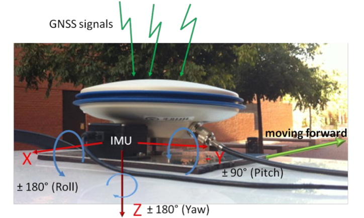
A new system developed by Universidad Carlos III de Madrid (UC3M) researchers uses sensors to improve the ability of GPS to determine a vehicle’s position compared to use of conventional GPS devices by up to 90 percent.
The prototype can guarantee the position of the vehicle to within 1 or 2 meters in urban settings, the researchers said.
Sensor Fusion. The prototype system incorporates a conventional GPS signal with those of other sensors (accelerometers and gyroscopes) to reduce the margin of error in establishing a location. “We have managed to improve the determination of a vehicle’s position in critical cases by between 50 and 90 percent, depending on the degree of the signals’ degradation and the time that is affecting the degradation on the GPS receiver,” said David Martín, a researcher at the Systems Intelligence Laboratory (LSI – Laboratorio de Sistemas Inteligentes) at UC3M. The system was jointly designed and developed by LSI and the Applied Artificial Intelligence Group (GIAA – Grupo de Inteligencia Aplicada Artificial).
The margin of error of a commercial GPS, such as those that are used in cars, is about 15 meters in an open field, where the receiver has wide visibility from the satellites. However, in an urban setting, the determination of a vehicle’s position can be off by more than 50 meters, due to the signals bouncing off of obstacles like buildings, trees, or narrow streets. In certain cases, such as in tunnels, communication is lost, hindering the GPS applications reaching Intelligent Transport Systems, which require a high level of security.
“Future applications that will benefit from the technology that we are currently working on will include cooperative driving, automatic maneuvers for the safety of pedestrians, autonomous vehicles or cooperative collision warning systems,” the scientists comment.
Integration of GNSS antenna of rover receiver and IMU in a platform over the roof of the vehicle.
The greatest problem presented by a commercial GPS in an urban setting is the loss of all satellite signals. “This occurs continually, but commercial receivers partially solve the problem by making use of the urban maps that attempt to position the vehicle in an approximate point,” Martín said. “These devices can indicate to the driver approximately where he is, but they cannot be used as a source of information in an Intelligent Transport System like those we have cited.”
The basic elements that make up this system are a GPS and a low-cost inertial measurement unit (IMU). The latter device integrates three accelerometers and three gyroscopes to measure changes in velocity and maneuvers performed by the vehicle. Then, everything is connected to a computer that has an application that merges the data and corrects the errors in the geographic coordinates. Enrique Martí of UC3M’s GIAA explains, “This software is based on an architecture that uses context information and a powerful algorithm (an unscented Kalman filter) that eliminates the instantaneous deviations caused by the degradation of the signals received by the GPS receiver or the total or partial loss of the satellites.”
The current prototype can be installed in any type of vehicle. It is already working on board the IVVI (Intelligent Vehicle based on Visual Information, pictured above), a car that has become a platform for research and experimentation for professors and students at the university.
The LSI and UC3M researchers working on this “intelligent car” can capture and interpret all of the information available on the road, and that drivers use. To do this, the team is using optical cameras, infrareds and lasers to detect whether drivers are crossing the lines on the road, or whether there are pedestrians in the vehicle’s path, as well as to adapt the speed to the traffic signals and analyze the driver’s level of sleepiness in real time.
Next Steps. The researchers will analyze the possibility of developing a system that makes use of the sensors that are built into smartphones, because intelligent telephones are equipped with more than ten sensors, such as an accelerometer, a gyroscope, a magnetometer, GPS and cameras, in addition to Wi-Fi, Bluetooth or GSM communications.
“We are now starting to work on the integration of this data fusion system into a mobile telephone,” said Enrique Martí, “so that it can integrate all of the measurements that come from its sensors in order to obtain the same result that we have now, but at an even much lower cost, since it is something that almost everyone can carry around in his pocket.”
Location-powered mobile advertising company Verve Mobile announced today it has closed its Series C financing led by Nokia Growth Partners, a global growth stage venture firm focused on mobile technology, services and media with participation from new investor Qualcomm Incorporated, acting through its venture investment group, Qualcomm Ventures (QCOM), and Series B lead investor BlueRun Ventures.
The capital will be used to further develop and expand Verve’s proprietary mobile location-based advertising and publishing products and to grow its marketing and sales capabilities.
“Verve’s focus is combining big data, location-based services (LBS) and ad technologies to make mobile advertising work better for advertisers and publishers,” said Tom MacIsaac, Verve Mobile CEO. “Nokia and Qualcomm are global leaders in mobile technology innovation and have important insights, assets, initiatives and relationships that can help Verve maintain its lead in location powered mobile advertising.”
John Gardner of Nokia Growth Partners has joined Verve’s Board in connection with the financing, and Quinn Li of Qualcomm Ventures has become a Board Observer.
Verve Mobile’s customers are national-brand advertisers who want to engage consumers on their mobile devices with location-aware, data-driven and highly targeted marketing, the company said. Verve has offices in New York, Washington D.C. and San Diego, California.
Telematics Detroit — scheduled for June 5-6, in Novi, Michigan — is a conference and exhibition focused on the entire telematics ecosystem. In 2012, 1800+ executives attended along with 100+ industry speakers.
Key topics this year include:
The Ultimate End-to-End Telematics Platform: Dispel the “killer app” myth to adopt an approach to connectivity that eschews the next big thing in favor of a holistic suite of connected services that encompasses CRM, HMI and content.
Turn the Car into a Money-Making Machine: Subscription-only models have failed to ignite mass adoption of connected vehicle services. Discover how to create a flexible micro-transactional platform that aligns with the service and payment demands of consumers.
Make Big Data Useful Data: Tackle the proliferation of vehicle generated information to debate the granularity of data collection required to provide OEMs with data sets relevant to optimizing the driving and vehicle ownership experience.
The Telematics Trojan Horse: Debate whether strategic partnerships with the titans of CE, including Apple, Google and Microsoft, will result in diminished OEM influence or translate into the ability to attract tech. loyal consumers and close the automotive innovation gap.
The Infotainment Ecosystem Reinvented: BMW, Ford and GM announce their connected car visions to gain cross-industry buy-in. Analyze whether opening up APIs and SDKs will attract third party developers by creating higher volumes to support a truly auto-centric business case.
SeeControl, a machine-to-machine (M2M) cloud service provider, announced today that it will add Quake Global’s Q4000 to its line of turnkey M2M solutions for agriculture and equipment telemetry.
The Q4000 is a dual-mode communication modem that will connect either to a satellite network or to a traditional ground-based wireless data network. The modem will automatically choose the most economical method of sending the data. The combined communication capabilities of the Q4000 and SeeControl’s turnkey telematics applications will allow equipment OEMs and owners to send and receive information from globally dispersed heavy equipment, harvesters, irrigation systems, fluid tanks, generators and vehicles.
“Our device store offers a vast selection of turnkey M2M sensor devices to enable mixed asset and fleet operations,” Said Bryan Kester, CEO of SeeControl. “Now, with Quake, this extends to effortless satellite and GSM connectivity in a single easy-to-deploy product. It is perfect for equipment owners that want to add new asset types to an existing global fleet, or for OEM equipment manufacturers designing the next generation of telematics programs.”
“We are very pleased to establish this relationship with SeeControl,” said Polina Braunstein, CEO of Quake. “They are a recognized leader in the agricultural OEM and Telematics solutions arena. We anticipate that considerable agriculture and equipment telematics innovation will be fueled by the global reach of the Q4000, combined with SeeControl’s software-as-a-service cloud for sensor reporting and analytics.”
The combined offering is on display at Booth P48 at the 2013 World Agricultural Expo, taking place now through Thursday in Tulare, California.
An agreement announced today between GE and Google will integrate Google Maps data into GE’s Smallworld electrical, telecommunications and gas applications.
GE, a provider of geospatial analytical tools and insight, and Google will help utilities increase productivity based on the ability to visualize and analyze their data with GE’s Smallworld product suite. The combined solution will enhance the existing network visualization capabilities and will allow utility customers to receive incremental efficiency and productivity of operations in the field. By enhancing the ability to visualize data on a map, utility customers will be able to quickly provide their end-use customers with important information such as outage restoration times and will help to more efficiently manage their network assets.
“We are relentlessly looking at ways to bring value to our customers and this agreement brings together two world-leading solutions providers to help improve productivity,” said Bryan Friehauf, product line leader—software solutions for GE’s Digital Energy business. “Millions of people are already familiar with Google Maps as seen on their computer screens in the office or on mobile devices in the field. Now we’re able to bring that familiarity to our Smallworld products so that our customers can use a platform that’s completely customized for their assets and networks.”
GE developed a set of small focused applications for the Web, mobile devices and desktops. Google’s rich mapping content will form an integral part of GE’s solutions, strengthening the existing geospatial capabilities of GE’s Smallworld products by providing out-of-the-box base mapping as well as visualization and analytics capabilities, the companies said.
GE’s Distribution Management Systems and Outage Management Systems also will use Google’s mapping content in the context of operational control of electricity networks. Notably, for field operators, GE will utilize Google’s Android platform to augment its existing portfolio of mobile products. The new portable solution will integrate Google Maps, providing better contextual information to users in the field.
“By using Google Maps and our API offering, GE is providing its customers with the advantage of a simple and intuitive user interface. Because so many people already know how to use Google Maps, this allows GE’s Smallworld technology to be an even more powerful enterprise solution,” said Tarun Bhatnagar, director, Google Geo Enterprise. “Both GE and Google have a heritage of innovation, and we look forward to working together to provide new ways to use and visualize data on a map.”
GE’s Smallworld geospatial solutions design and model complex network infrastructures while supporting asset management life-cycle processes and producing solutions for companies with complex network asset management problems. The agreement will deliver those solutions for applications such as business intelligence, engineering, Web clients, schematics, corridor management and enterprise gateway.
“We believe together, GE and Google will utilize their unique combination of technical talent and capabilities to significantly enhance the efficiency of their operations in a wide array of applications,” said Friehauf. “Ultimately, our customers will notice significant benefits from this new agreement.”