The Society of Exploration Geophysicists (SEG) has published an article describing how two energy companies used satellite imagery to accurately locate and then try and unravel part of the mystery surrounding a British Royal Air Force (RAF) fighter plane lost in the Egyptian desert since World War II. Contributed by Spatial Energy and Apache Corp., the article appears in the February 2013 issue of SEG’s monthly publication, The Leading Edge.
Discovery of the Curtiss P-40 Kittyhawk in March 2012 by a Polish exploration group made international headlines, prompting the RAF to search its archive for more information. The fighter was reportedly flown by Flight Sargent Dennis Copping when it went missing over the Egyptian Sahara in June 1942. Copping was never found and presumed dead.
The absence of remains at the crash site concerned Mohamed Abdel Aziz, a desert guide who traveled to the site days after the initial discovery. Having worked for Apache Corp. in exploration projects, Abdel Aziz reached out to Apache geologist Bill Bosworth with a question: Could the satellite imagery used so often in energy development help shed light on the fate of the missing flyer?
“We felt that using any technology within our means to possibly find and bring the pilot’s remains back to Britain was the right thing to do,” said Apache’s Bosworth.
He put in a request to Spatial Energy, a global services firm that specializes in processing, supplying and managing geospatial data, such as satellite imagery, for oil and gas companies worldwide. Spatial Energy concluded that a 32-foot-long aircraft exposed in the rocky desert should easily be visible in the commercial imagery captured by DigitalGlobe’s WorldView-2 satellite, which typically resolves features just 18 inches in diameter.
“In addition to honoring the memory of a fallen war hero, this project illustrates the constantly expanding utility of satellite imagery in the energy development cycle to include archaeological preservation,” said Chris Carlston, managing director of Spatial Energy GmbH in Austria.
Satellite images and information derived from them are routinely applied in every aspect of oil and gas development, from exploration and appraisal to production and restoration. Energy development companies rely on imagery to help them minimize disturbance to fragile environments and return the surroundings to their natural conditions when operations are completed.
“In many parts of the world, energy companies go to great lengths to avoid archaeological artifacts in the areas where they work,” Carlston said. “The Kittyhawk project in Egypt illustrates the important role imagery can play in identifying, mapping and preserving historical sites in difficult terrain.”
Although the Kittyhawk was accurately pinpointed in the WorldView-2 imagery, the satellite scene failed to provide insights into the pilot’s final resting place. The accurate location information, however, assisted in the quick recovery of the aircraft from the crash site before it was disturbed by souvenir seekers. Sargent Copping’s Kittyhawk is reportedly on its way to a museum for restoration and eventual display.
Red Hen Systems offers VMS-HDII Gas Finder, a turnkey pipeline patrol service solution. It detects pipeline gas leaks in parts per million (ppm) while capturing their locations on maps and video. This combination of Red Hens’ VMS-333 hardware and Boreal GasFinderAB laser delivers the information decision-makers need in order to quickly respond to problematic cracks or leaks in pipelines, the company said.
Red Hen Systems President Neil Havermale said the VMS-HDII Gas Finder is easier to use and more cost effective than other pipeline patrol solutions. “Simply put, our process involves gathering customer’s important data, processing their data, and making it available to them whenever and wherever they please.”
Designed specifically for pipeline corridor patrol and field-tested over the course of many years, this robust system helps enable companies to meet FERC compliance, keep patrol costs down and, detect leaks or defects in rugged and inaccessible terrain. Once leak detection data, video data, and mapping data are collected Red Hen Systems provides anytime, anywhere viewing via Google Earth or ESRI ArcGIS. Video images of the locations of detected gas leaks help companies identify the source, while providing a visual reference to integrity maintenance crews deployed to address the problem. With more than 80 percent of methane leaks occurring within pipeline corridors and related surface equipment, reliable detection and location data is vital.
The VMS-HDII Gas Finder offers a reliable means for maintaining the integrity of nearby assets and assuring the safety and wellbeing of populations and the environment. Boreal laser technology, which is used in our pipeline patrol service, was tested at the Rocky Mountain Oil Field Testing Center (RMOTC) where it substantially out-performed other gas leak detection devices tested at the facility, the company said. Data is collected during corridor patrol with a video camera, a GPS unit, and a high-definition video recorder. The VMS-HDII simultaneously records several streams of data as one file to be mapped following the operation. The gas detection map is viewable anytime, anywhere on Google Earth or ESRI ArcGIS through Red Hen Systems’ server.
The map visually indicates where each leak was detected by the Boreal Laser and is paired with the measurement of each leak in parts per million. Red Hen Systems recognizes that not all companies’ needs are the same, allowing the VMS-HDII Gas Finder to be customized to meet individual specifications.
Magellan today announced that it has expanded the worldwide availability of the Magellan Switch Series of crossover GPS watches to Europe for athletes who run, bike, swim or participate in a variety of outdoor activities. The Magellan Switch and Switch Up watches are available this month from select retailers and through Magellan’s European distribution network.
To support its European users, Magellan has also expanded its Magellan Active website with additional languages including French, Spanish, German, Italian and Dutch as well as English. Magellan Active makes it convenient for multisport athletes who record their performance data on Magellan’s Switch Series to easily upload and track data online with intuitive charts, maps and metrics, from a single location, Magellan said.
“Magellan is continuing to further enrich the lives of multi-sport athletes worldwide with best-in-class fitness watches and innovative tools to help them take control of their active lifestyles,” said Clark Weber, Senior Director of Fitness Products for Magellan. “The Switch Series is rapidly gaining popularity with fitness enthusiasts, and we are pleased to work with our European distribution partners to make our GPS watches available to consumers throughout Europe.”
Both Switch watches include features such as an Activity Pacer that shows runners if they are on target with their goal, and provides specific targets to attain the desired result. The Switch GPS watch, designed primarily for runners, includes nine customizable sport profiles, high-resolution display, eight hours of battery life, a high-sensitivity GPS receiver, 50-meter water resistance, and compatibility with ANT+ sensors. The Switch Up GPS watch has the same features as the Switch GPS watch but includes a barometric altimeter for precise elevation data, a thermometer to monitor and capture outside temperature, vibration alerts for notification in louder environments, and a quick-release mounting system to transition between sports.
The Magellan Switch Series is available from Magellan’s European distribution partners serving UK, France, Germany, Turkey, Spain, Italy, Austria, Switzerland and Benelux.
Developer API Program. Magellan also is making available its Magellan Active Developer API program. Third-party websites and applications can now access activity data from Magellan Active and import data into their websites once customer permission has been granted. A Magellan Active Web Widget can be embedded in any website for uploading activities and gives users the ability to upload activities and perform device software updates from within a personal website or HTML Widget/Gadget.
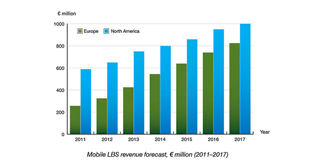
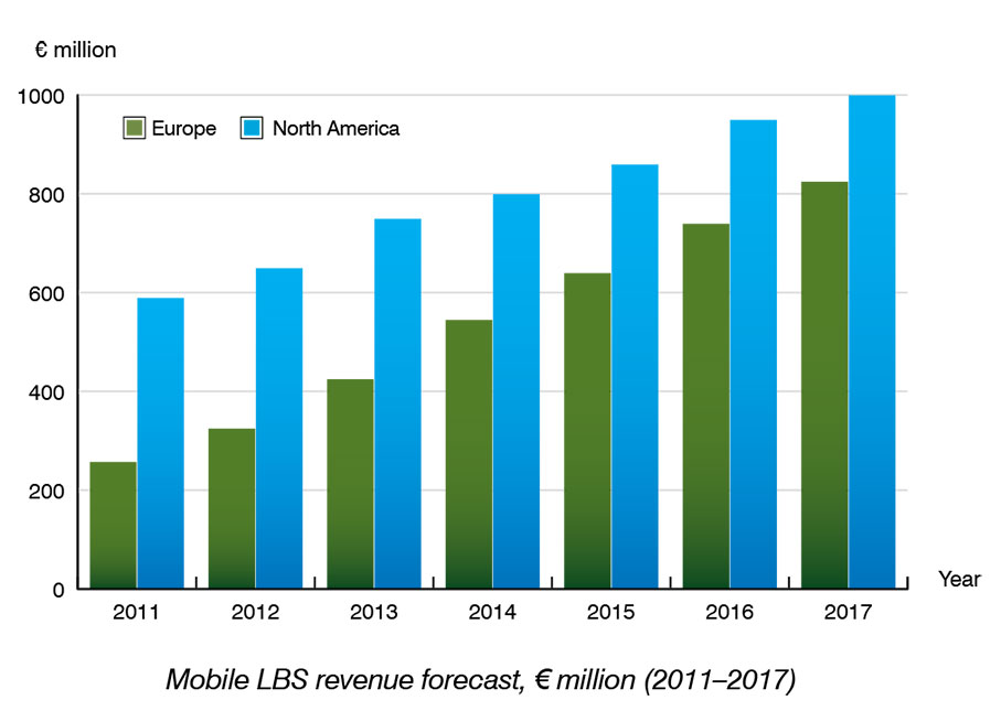
According to a new research report by Berg Insight, mobile location-based service (LBS) revenues in Europe are forecast to grow from €325 million in 2012 at a compound annual growth rate (CAGR) of 20.5 percent to reach €825 million in 2017.
The North American LBS market is forecast to grow at a CAGR of 9.2 percent from US $835 million in 2012 to reach US $1,295 million in 2017. Berg Insight estimates that 40 percent of all mobile subscribers in Europe use some kind of location-enhanced application on a regular basis. In North America, the larger installed base of GPS-enabled handsets and smartphones has enabled higher uptake of LBS.
Berg Insight estimates that about 50 percent of all mobile subscribers in the region now access LBS at least monthly. Local search, social networking and navigation services are the top application categories in terms of number of active users. Mobile workforce management services that aim to improve operational efficiency for businesses are also gaining traction in new industry segments.
“Smartphones are the most important enabler for LBS adoption in general. The installed base of smartphones in Europe has now reached 45 percent of total handsets and already surpassed 55 percent in North America,” said André Malm, Senior Analyst, Berg Insight. He adds that besides differences in smartphone adoption, there are other regional differences. “Mobile operators still play a more central role in North America than in Europe, marketing branded services to both consumer and enterprise customers.”
However, the operators’ central role in the LBS ecosystem is now being challenged by the smartphone ecosystems that bundle key LBS and give developers access to location data and distribution channels in the form of on-device app stores. Mobile operators are therefore showing renewed interest in offering network-based bulk location data for advertising and analytics, as well as new services such as secure authentication and fraud management.
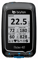
Bryton Incorporated has chosen to integrate u-blox’ UBX-G6010 GPS single chip to give its sports electronics products location-aware features. Founded in 2009, Taiwan-based Bryton has established a brand of GPS-enabled sports monitoring devices dedicated to four main activities: cycling, fitness, outdoor adventure and athletic training.
“At Bryton, we understand the mindset of sport enthusiasts, and know exactly what they are looking for when they shop for electronic equipment to enhance their exercise experience: it must be smart, small, attractive, accurate, dependable, and packed with interesting and useful features that make their workouts more fun and informative,” said Wolf Lin, President at Bryton Inc.
“u-blox’ extremely small GPS chip solution requires very few external components, meaning we don’t need to allocate much space in our products to achieve state-of-the-art, extremely sensitive GPS positioning capability,” added Lin. “Another primary feature is long battery life. Thanks to u-blox’ low power chip design with sophisticated power saving modes, the GPS receiver, which must be active much of the time, requires only a small fraction of the device’s power.”
Bryton evaluated leading vendors of GPS technology and selected u‑blox’ GPS single-chip based on four key product features: small size, high sensitivity, low-power consumption, and upgradability.
Bryton markets its products under two main product categories:
Rider. An extensive line of waterproof bike computers that provide navigation while monitoring location, distance, elevation, route history as well as heart rate and calories usage.
Cardio. Smart sports watches for runners with integrated GPS that delivers accurate time, pace, distance, stride, lap information and much more.
Next month Spirent is hosting a meeting with hands-on training sessions on GNSS simulation equipment led by Spirent engineers. The 2013 Spirent Federal 2013 GNSS Technical Interchange Meeting will be held March 19-21 at the DoubleTree Hotel Anaheim-Orange County, in Orange, California.
March 19 and 20 are for general participation. The third day, March 21, features FOUO (For Official Use Only) sessions for U.S. citizens only.
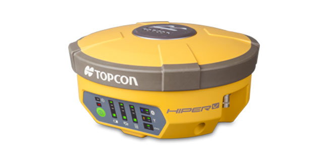
Topcon has introduced the HiPer V receiver, which features Topcon’s Vanguard technology. The HiPer V provides users with the choice of GPS and GLONASS signals (as well as Galileo when operationally available), and also includes a variety of choices of internal radio, cellular and Bluetooth communication options and what Topcon calls a state-of-the-art power supply.
The core of the HiPer V is the new Vanguard GNSS technology, according to Ewout Korpershoek, Topcon senior vice president and chief marketing officer. With its 226 channels and Universal Tracking, the Vanguard chipset is future proof, as it will track signals from all available and currently planned GPS, GLONASS and Galileo satellites.
“Topcon’s Universal Tracking provides a whole new definition of ‘channel technology.’ There is nothing available like it. Universal Tracking allows a single receiver channel to ‘automatically’ select and track any satellite signal,” Korpershoek said. “Because our channels are not pre-programmed to receive only one specific signal or a type of signal, Topcon users will always receive the maximum number of signals at any given time. In addition, Topcon’s Universal Tracking will automatically weigh the best combination of available signals based on health, geometry and application, providing unmatched accuracy, speed of initialization and fixing. HiPer V will work at places where other receivers will not, at highest accuracy, and with greatest ease of use.”
Other features include the rugged, durable magnesium alloy housing, the choice of communication options, “and longest life rechargeable battery while maintaining the lightest weight in its class,” Korpershoek said.
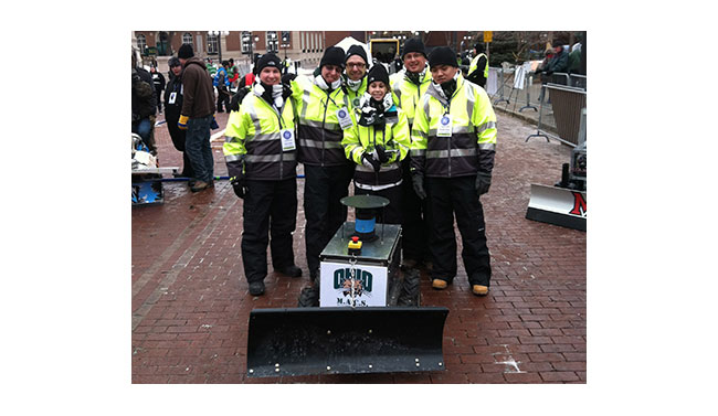
The Institute of Navigation (ION) Satellite Division held its third annual ION Autonomous Snowplow Competition January 24-27 at Rice Park in downtown Saint Paul, Minnesota, as part of the 127th Saint Paul Winter Carnival.
Sponsored by The ION Satellite Division and held in cooperation with the ION North Star Section, the ION Annual Autonomous Snowplow Competition is a national event open to college and university students, as well as the general public, that challenges teams to design, build, and operate a fully autonomous snowplow using navigation and control technologies to rapidly, accurately and safely clear a designated path of snow.
Eight teams participated in the four-day competition, each using state-of-the-art navigation systems to plow two different snowfields. Teams included students, partners from private industry and faculty advisors from Case Western Reserve University; Dunwoody College of Technology; Miami University (Ohio); Ohio University; The University of Michigan – Dearborn, and The University of Minnesota.
Teams were judged based on their cumulative scores earned throughout the competition phases: 75 percent of the total score was based upon the plowing competition; and 25 percent of the total score was based on the presentations and pre-event report.
First place was awarded to Ohio University’s Avionics Engineering Center with students Samantha Craig, Ryan Kollar, Adam Naab-Levy, Pengfei Duan and Kuangmin Li with support from faculty advisors Dr. Frank van Graas, Dr. Wouter Pelgrum and Dr. Maarten Uijt de Haag who submitted their four-wheeled Monocular Autonomously Controlled Snowplow (M.A.C.S.). The first place prize included $5,000 and a golden snow globe trophy. Ohio University also captured the Best Student Presentation Award that included $500 and the “Golden Shovel” Award and the Best Written Report that included $500 and the “Golden Pen” Award.
Second place was awarded to the Miami University team “RedBlade” that included students Mark Carroll, Chad Sobota, Robert Cole, Richard Marcus, Harrison Bourne, Jamie Morton and Michael Harris with support from advisors Dr. Yu (Jade) Morton, Dr. Peter Jamieson, Steve Taylor. The second place prize included $4,000 and a silver snow globe trophy.
Third place was awarded to the University of Michigan (Dearborn) team “Yeti 3.0” that included students Angelo Bertani, Zachary DeGeorge, Ahmed Alkirsh, Abdelqwee Yaffai, Mark Bajor, Craig Cowling, Cody Schmitt, Jacob Mack and Mengxing (Simon) Chen with support from faculty advisor Narasimhamurthi (Nattu) Natarajan. The third place prize included $3,000 and a bronze snow globe trophy.
In addition, the first place team, Ohio University, has been invited to display its winning snowplow during ION GNSS+ 2013 conference September 16-20 in Nashville, Tennessee.
Sponsors of the second annual ION Autonomous Snowplow Competition included Honeywell, Inc., Alliant Techsystems Inc., Lockheed Martin Corporation, ASTER Labs, Inc., Space Exploration Technologies Corp., The Toro Company, Proto Labs, Inc. and U.S. Bank.
The Fourth Annual ION Autonomous Snowplow Competition will be held in January 2014 at the Saint Paul Winter Carnival, St. Paul, Minnesota.
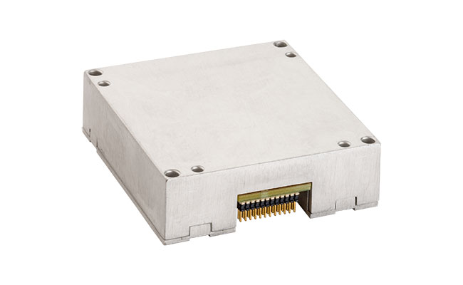
NovAtel Inc., supplier of OEM GNSS components and subsystems, has announced the addition of a new commercially exportable MEMS IMU to its line of SPAN GNSS/INS products. Available for immediate shipping, this custom Analogue Devices MEMS inertial sensor is exclusive to NovAtel, and can be paired with an OEM6 receiver card to provide continuously available position, velocity and attitude (roll, pitch, yaw) in a small, single-unit form factor.
SPAN tightly couples NovAtel’s precise GNSS technology with highly accurate inertial measurement technology to provide a robust, stable and continuous 3D navigation. The new OEM-ADIS-16488 sensor is designed to be coupled with NovAtel’s OEM6 receivers via the MEMS Interface Card (MIC), providing integrators with a compact, powerful GNSS/INS engine, NovAtel said.
The OEM-ADIS-16488 features low noise gyros and accelerometers in a small, lightweight form factor. This IMU enables precision measurements for applications that require low cost, high performance and rugged durability. Tight-coupling of the two technologies enables continuous robust positioning in difficult environments where satellite signals are unreliable or unavailable for short periods of time.
The OEM-ADIS-16488 is now available for order and immediate shipment.
For quite some time, I’ve been writing in GPS World magazine and speaking at conferences about the declining prices of high-precision GNSS receivers and how the cost of high-precision data (especially vertical) is going to decline substantially. For my colleagues in Asia, Africa, Europe, and South America, you’ve already seen this. Dual-frequency, multi-constellation GNSS receiver prices in those areas are significantly lower than in the United States and Canada.
Previously, I’ve presented to you that I think dual-frequency (L1/L5), dual-constellation (GPS/Galileo) GNSS receivers will be inexpensive in the future. My reasoning, simply, is that L5 is an open signal (legacy L2 is not) and supported by both GPS and Galileo. Furthermore, both GPS and Galileo use a CDMA radio technology, so designing a GPS/Galileo receiver is a heck of a lot easier than a GPS/GLONASS receiver. Therefore, unlike today’s GNSS receiver competitive landscape of only a dozen or so manufacturers of high-precision GNSS receivers, there will be dozensssss (emphasis on s) and maybe hundreds of high-precision GNSS receiver manufacturers, based on oodles of L1/L5 GNSS chipsets that are sure to come.
Will all GNSS chipset designers decide to expend the extra energy it takes to optimize their chipset for RTK FIX or Float solution? No, but certainly there will be “boutique” GNSS chip designers that will specialize in high-precision designs. It likely won’t be the companies selling a $3 GNSS chip to Apple or Samsung today. Those companies rely on selling tens (or hundreds) of millions of GNSS chips per year. I’m talking about companies that can survive on selling hundreds of thousands of high-precision GNSS chipsets for $50-100 each.
However, Galileo is still at least two years from a minimal usable constellation and the GPS operator, the U.S. Air Force, is in no hurry to launch GPS satellites with new capabilities (for example, L5) — so low-cost, high-precision GNSS chipsets are still a couple of years away. If this is the case, then why are high-precision GNSS receiver prices declining in some areas today?
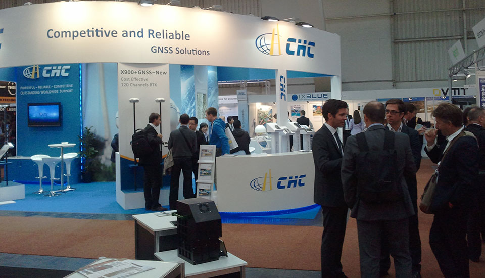
As I mentioned before, our colleagues in Asia, Africa, Europe, and South America are already seeing lower-cost high-precision GNSS receivers. There are brands offered in those geographic regions that aren’t known (or are very little known) in the U.S. and Canada. Brands like Stonex, FOIF, BHCNav, CHCNav, and others market themselves outside of the U.S. and Canadian markets, but not much in the United States or Canada. The increased competition in those foreign markets has driven high-precision GNSS prices down.
The CHC booth at Intergeo 2012.
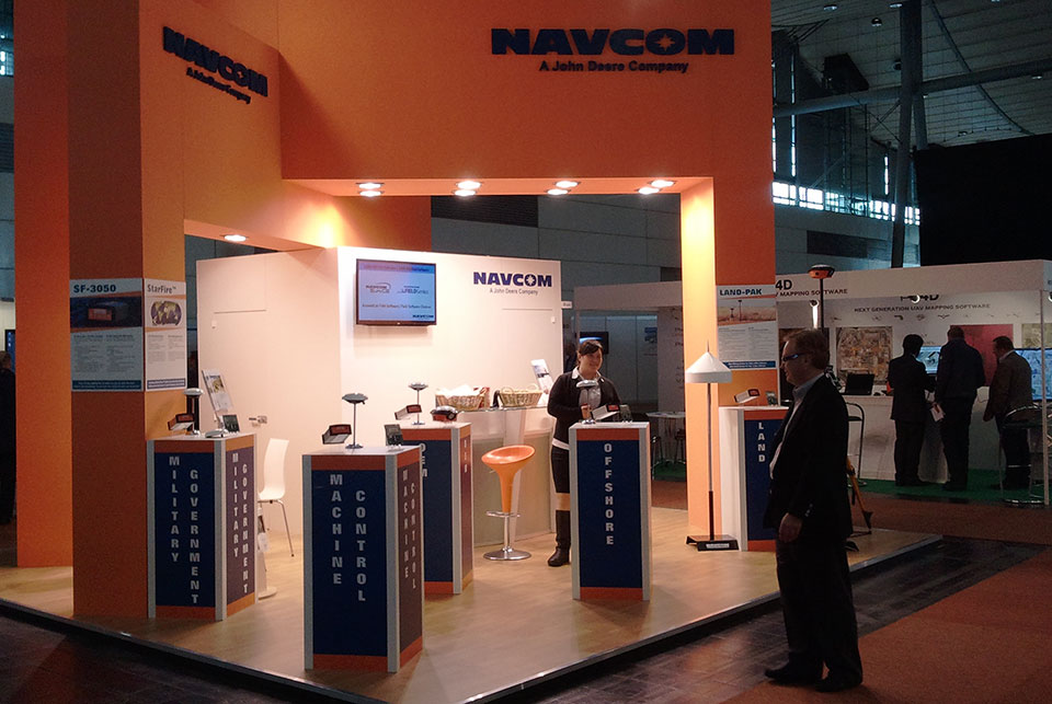
The reason high-precision GNSS prices are still high in the U.S. and Canadian markets are because it’s still primarily a Trimble, Leica, Topcon game. Yes, there are other brands like Ashtech/Spectra-Precision, SXBlue, Javad, Sokkia, Hemisphere, Altus, and Navcom, that may offer entry-level entry points, but the Big Three still dominate the U.S. and Canadian markets, partly because of their broader product lines and mostly because they have the best network of dealers. Differing from the others in this mix is Navcom, a subsidiary of John Deere & Co. Navcom’s GNSS technology is distributed by Deere & Co, and is focused almost exclusively on the agriculture market.
In the United States and Canada, high-precision GNSS receiver users are still willing to pay a premium for leading brand-name products and their dealer networks. You might think that there’s a lot of price pressure from the other brands. There is some, but some of the other brands are owned by the big boys. Trimble owns Spectra-Precision and Ashtech. Topcon owns Sokkia.
Spectra Precision (here at Intergeo 2012) is owned by Trimble.
For there to be serious price movement in the United States and Canada as there has been in other areas of the world requires more competition. I think we’re going to start to see more of that.
I know you don’t want to hear this, but the competition for high-precision GNSS receivers is coming from China — and it’s serious competition. Chinese GNSS receiver manufacturers are already well-established in Africa, Europe, and Asia (of course). Their high-precision GNSS gear is coming soon to a place near you.
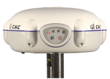
What exactly is a Chinese-made GNSS receiver? Mostly, they are receivers made using the guts (GNSS receiver boards) from mainstream GNSS receiver designers like Trimble, Topcon, NovAtel, and Hemisphere. The Chinese companies buy these receiver boards and design their own cases, battery packs, and other supporting systems around the GNSS receiver board. The finished products, like the CHCNav X91, look much like what you see from Trimble/Topcon/Leica today, and it sports a Trimble or Novatel GNSS receiver inside, for fraction of the price you’ll pay for the equivalent Trimble GNSS receiver.
Of course, you wouldn’t benefit from Trimble (or whomever) dealer network support, and you would be risking that the manufacturer has designed a reliable system around the GNSS receiver board. What happens if the receiver needs service? Where’s the nearest support center? Who do you call? These are all very valid questions that any prudent businessperson would ask themself before making a significant equipment purchase.
Some of the Chinese manufacturers rely on low price to attract your attention and then offer minimal customer support. Others, like CHCNav, are addressing this by setting up regional centers around the globe for support and repair. Can they produce high-quality GNSS products that will meet the expectations of U.S. and Canadian buyers? The reputation of Chinese manufactured products in the surveying market is not very good. Will they have the staying power to hang on for a few years, long enough to gain the confidence of U.S. and Canadian users?
In their favor is their home market. China is the largest consumer of high-precision GNSS receivers in the world. In fact, it’s been said that more high-precision receivers are sold in China than in the rest of the world combined. Even if that’s not an accurate statement, it’s not incorrect by very much. That tells you something about the size of the Chinese market for high-precision receivers. With a market that size, I think it’s safe to say that Chinese receiver manufacturers are gaining a lot of experience in designing and manufacturing GNSS receivers, and one can assume that the next-generation receiver design is better than the previous one.
While they haven’t quite ventured into offering their own GNSS receiver designs (still buying GNSS receiver “guts” from established manufacturers), last week one Chinese manufacturer took a step closer to doing so. On January 31, Hemisphere GPS announced that Beijing UniStrong Science & Technology Co Ltd. is acquiring Hemisphere’s core GPS design/manufacturing business. Hemisphere has chosen to divest itself of all non-agriculture related businesses and rename the company AgJunction, the same name as a software company it acquired recently. Of course, GNSS technology is highly related to agriculture, and there’s no doubt that AgJunction will continue to use GNSS technology, but clearly the AgJunction management team doesn’t think it’s an important enough technology to have to own it.
UniStrong is no stranger to the GPS/GNSS business and is no small fry. It’s been in business since the mid-1990s and boasts more than 1,000 employees, offering a wide variety of high-precision GPS/GNSS receiver solutions from handheld GIS receivers to full-blown RTK GNSS receivers. With this acquisition (US $15 million), it becomes the first Chinese-owned GNSS receiver design/manufacturing group in North America.
Thanks, and see you next time.
Follow me on Twitter.
Navcom, a subsidiary of John Deere, focuses on the ag market.
Trimble is launching a high-accuracy correction service for the agriculture market. The Trimble RangePoint RTX correction service is expected to be available in March.
According to Trimble, the RangePoint RTX service is an introductory, cost-effective correction service available to farmers across the contiguous U.S. as well as most of Canada, South America, Russia, and the Commonwealth of Independent States, Africa, Asia and Australasia. It’s designed for broadacre agriculture applications. For 2013, all compatible devices — the Trimble CFX-750 display, FmX integrated display, and the AG-372 GNSS receiver — are eligible for an introductory, free 12-month subscription to the RangePoint RTX correction service.
The new service uses satellite broadcast capabilities to deliver real-time accuracies of better than 50-centimeter (20-inch) repeatable, or a superior 15-centimeter (6-inch) pass-to-pass, and does not require the use of traditional reference station infrastructure. Trimble RTX technology supports both GPS and GLONASS satellite constellations, increasing accuracy and reliability for users by leveraging the availability of multiple satellite systems. As a result, the RangePoint RTX service can provide a more accurate, reliable correction solution than some of the traditional Satellite Based Augmentation Systems (SBAS), and is also available in certain geographic areas where SBAS is not currently accessible.
“Trimble is committed to expanding the services and software applications that we provide to the global farming community,” said Mike Martinez, market manager for Trimble’s Agriculture Division. “We recently expanded the availability of real-time, satellite-delivered corrections to most of the world through Trimble’s CenterPoint RTX correction service. Now, we are enhancing the Trimble correction services portfolio by providing an introductory RTX-based option for farmers looking for more accuracy at an affordable price point. Our customers want a broad range of solutions, and we’re delivering those options.”
Trimble RangePoint RTX real-time satellite delivered corrections can be received directly by compatible GNSS receivers, so there are no additional costs for mobile data plans or requirements for additional hardware such as radios and antennas. The RangePoint RTX service is compatible with the Trimble CFX-750 display, FmX integrated display and the AG-372 GNSS receiver.
On January 31, Hemisphere GNSS Inc., a subsidiary of Beijing UniStrong Science & Technology Co. Ltd., purchased the Precision Products business and related GNSS technology and intellectual property from Hemisphere GPS Inc. for $15 million US. In a related press release, Hemisphere GPS Inc. has announced the intention to change its company name to AgJunction.
As part of the transaction, Hemisphere GNSS acquired all of the high-precision GNSS product lines, all related intellectual property rights and the Hemisphere GPS trademarks and brands. The Precision Products segment generated revenues of approximately $13.3 million in 2012 serving marine, land survey, construction, mapping, and OEM segments.
Hemisphere GNSS will operate its business headquarters out of Scottsdale, Arizona, and will maintain its operations in Calgary, Alberta, Canada.
Phil Gabriel has been appointed president of Hemisphere GNSS Inc. and will also serve as a board member. Gabriel has more than 15 years of experience with Hemisphere GPS, serving for the past six years as the vice president and general manager of the Precision Products business. “We are truly excited about our future growth prospects as a fully focused GNSS products and technology provider,” Gabriel said. “I would like to assure all our global distribution partners, suppliers and customers that it remains business as usual as we take our first steps forward with the strong backing of UniStrong.”
With this acquisition, UniStrong is expanding its capabilities in the high-precision GNSS business and also expects to promote commercial applications of China’s BeiDou Navigation System. UniStrong is listed on the Shenzhen Stock Exchange under ticker 002383.
Business analysts have reported in China that this is the first acquisition of an internationally renowned enterprise initiated by a domestic enterprise in China’s satellite navigation industry and represents an important milestone in the development of the industry. “The acquisition will create an international route enabling UniStrong to expand its global business outlook, enhance our ability to attract international talent, and lay the foundation for international growth and profitability,” stated Xingping Guo, president and CEO of UniStrong.
As part of the agreement, Hemisphere GNSS and AgJunction have formed a strategic alliance and a collaborative business relationship covering supply chain management, customer support, technology development and cross-licensing. “Having already established a relationship with UniStrong as one of our resellers made our new alliance a win-win for both parties,” said Rick Heiniger, president and CEO of AgJunction. “I am very pleased to be working together in this close technology-sharing relationship.”
Hemisphere GNSS’s newly appointed board of directors brings additional GNSS industry experience to the company. The board is chaired by Jonathan W. Ladd, former president and CEO of NovAtel Inc. Also joining the board is Werner Gartner, former executive vice president and CFO of NovAtel Inc.
“Hemisphere’s talented team will leverage its core GNSS capabilities and product marketing knowledge with UniStrong’s high quality, low cost GNSS product design and development resources,” said Ladd. “Hemisphere’s existing and future customers and partners will most certainly benefit from the resulting rapid, cost-effective product innovation across multiple product lines.”
Beijing UniStrong is focused on GNSS industry, with R&D, production, engineering, sales and service facilities. Its technical solutions and products cover GPS/GLONASS/COMPASS receivers, multi-system navigation and positioning, high-accuracy surveying, GNSS data post-processing, and system integration.
The re-branding of Hemisphere GPS as AgJunction is an integral part of the strategic re-focusing of the company’s resources on precision agriculture, and part of the restructuring initiated in September 2012. The company maintains ownership of its key patents and leading agricultural brands including AgJunction, Outback Guidance, and Satloc.