Most GPS devices in cars today give the driver two choices: shortest route or fastest route. GreenGPS provides a third option: most fuel-efficient route.
With gas prices skyrocketing, many drivers would be happy to spend a few more minutes on the road, or take a different route, if it meant burning less gas.
The answer could be the GreenGPS navigation service, now being developed by researchers at the University of Illinois at Urbana Champaign (UIUC), which finds the most fuel-efficient route for your vehicle.
“The most fuel-efficient route may be different from the shortest route because the latter may pass through downtown stop-and-go traffic,” explained Tarek Abdelzaher, project lead and computer science professor. “It may also be different from the fastest route because vehicles are not as fuel efficient at higher speeds.”
All cars manufactured in the U.S. since 1996 come with a standard interface to their internal gauges and engine measurements called the On-Board Diagnostics Interface, or OBD-II. GreenGPS runs on the driver’s GPS-enabled cell phone and uses an off-the-shelf wireless adaptor plugged into the vehicle’s OBD-II port to receive engine readings via Bluetooth.
The cell phone collects the readings and connects to a server that models the engine’s fuel efficiency and customizes navigation advice to the particular vehicle, Abdelzaher explained.
The best route computed by GreenGPS to the same destination may differ from one vehicle to another. “For example, my vehicle uses about 20-25 percent more gas in stop-and-go traffic compared to free-flowing traffic, whereas my wife’s car uses closer to 40 percent more,” Abdelzaher said. “GreenGPS may recommend to her a path that is longer but has no traffic, whereas it might recommend to me a path that incurs some traffic but is shorter.”
To users, GreenGPS looks like a regular navigation service. The driver specifies a destination, then ask the service to find a route. “It runs on your cell phone, except that in addition to the fastest and shortest route options, it offers the ‘least-fuel route’ option,” Abdelzaher said. “If the driver chooses that option, they receive the GreenGPS-recommended fuel-efficient route.”
The program works best with a small hardware addition to collect readings specific to the vehicle. “In order for the advice to be customized to the performance of your specific vehicle, the driver should invest in buying the OBD-II adaptor. It costs about $50 and is a one-time investment,” Abdelzaher said.
“If the driver does not wish to buy the adaptor, they can still use GreenGPS and supply the make, model, and year of their vehicle. In this case, GreenGPS will use data from other vehicles of the same make, model, and year, or vehicles as close to them as possible to compute the navigation advice,” Abdelzaher said. This social networking component is also being developed as part of the project.
The system pulls the GPS data from the driver’s cellphone. “If you use a GPS phone (and most smartphones have GPS), the system simply finds out your current location from your phone. Otherwise, you would need to supply both source and destination addresses (like you would when you get directions from Google Maps) and the system will show you the route on a map.”
Gas-Saving Pilots. In the first stage of testing, the team solicited volunteers to drive in the area of their university, in Urbana-Champaign, a city of 170,000. In all, 1,000 miles were driven by 16 different cars. Results demonstrated that following the fuel-efficient route saves on average 6 percent over the shortest route, and 13 percent over the fastest. “This was done on flat terrain and in the absence of significant congestion,” Abdelzaher said. “We expect that testing in higher traffic and richer topology will increase the variability in fuel consumption among different routes, resulting in even more potential savings when following the most fuel-efficient route. Verifying this conjecture is currently a topic of investigation for our ongoing research project.”
Abdelzaher said his team has just started the second stage. “In the second stage of testing, we will deploy GreenGPS on the UIUC Facilities and Services fleet (about 100 cars) and monitor performance over a longer period of time. Preparations for this deployment are currently under way. We also expect to offer GreenGPS publicly to any other volunteers who wish to help with testing.”
Impressed by early findings of gas savings, the second phase is being funded in part by a $300,000 grant from the National Science Foundation. Abdelzaher and Robin Kravets, another UIUC computer science faculty member, were awarded the grant this spring. It will help deploy GreenGPS among the campus fleet cars, and track and analyze the results.
“By sharing data on speed, fuel efficiency, and location of vehicles, better real-time navigation services can be developed that guide drivers to routes that are maximally fuel-efficient for their cars, hence reducing transportation carbon footprint,” the grant reads. “This project helps usher in a new era of sensing applications with more integration of humans, networks, and the physical world, which may have a significant impact on the economy, energy, and the environment by reducing transportation energy cost and carbon footprint.”
Other grant providers are the Office of Naval Research, which is funding research on the technology’s networking component, and IBM through its Smarter Planet initiative. As a part of this project, 200 or more cars in the Urbana-Champaign area of various makes and models will be fitted with GreenGPS. Through a social network of drivers, data and routes collected can be shared and used by those who don’t have the OBM-II adaptor installed.
Fuel consumptions for the various roundtrips between different landmarks.The landmarks and corresponding shortest and fastest routes.
Operation Waypoint, a Minnesota-based, non-profit program administered by American Legion Post 621, has broadened its program from a state and regional focus to national in scope with its new website, gpsfortroops.org.
Run by volunteers, the program is committed to increasing the safety of military men and women deploying to the Middle East with the guidance of highly accurate, handheld GPS units and mapping cards for Iraq and Afghanistan. Since its inception, Operation Waypoint has relied heavily on its partnership with GPS device manufacturer Lowrance to provide GPS products and charts to soldiers preparing to serve, as well as generous donations from service and social organizations and numerous individuals to fund the effort.
Operation Waypoint was started in 2005 by retired educator Ed Meyer after a former student, preparing for deployment to Iraq, contacted him to ask what type of GPS unit would be best for his mission. As the military only provides one GPS device per unit, which is usually mounted in a vehicle, Meyer contacted a friend at Lowrance, requested three GPS handheld devices, and trained the company commander and two former students how to use them.
Close Call in Baghdad. Shortly after the soldiers arrived in Iraq, while traveling at night, their 24-vehicle convoy took a wrong into a dangerous Baghdad neighborhood following the lead truck’s Army-issued GPS unit. Realizing the mistake, the convoy commander called Sgt. Gaylen Heacock, one of the soldiers equipped with a Lowrance GPS supplied by Meyer. Heacock’s device determined the correct route and was able to guide the convoy to safety. Upon hearing of how the Lowrance units aided in safety, Meyer worked through the American Legion Auxiliary and Post 621 to broaden the idea into a full not-for-profit program.
“Our goal is to spearhead an even larger movement where communities nationwide can directly support our troops in a very meaningful way,” said Meyer. “I believe that every soldier that feels a GPS would aid them in their mission in the Middle East should have one with them.”
With the enhancement of GPS accuracy and advanced features, today’s GPS units are even better suited to the challenges often seen by the military than when the program began. Operation Waypoint provides soldiers with Lowrance Endura Safari handheld GPS units that contain a precision GPS+WAAS antenna with 42-channel receiver and 3-axis magnetic compass to ensure troops have pinpoint accuracy for proper guidance or calling in air support when needed. The combination of the touchscreen, simple menus, and the ability to control one-handed or with gloves keeps usability fast and seamless, Meyer said. However, the most important benefit is the ability to store up to 2,000 waypoints for areas of safe passage, suspected insurgent buildings, and other items that are marked and identified with any of 193 different icons and then shared between GPS units over time or added to satellite maps.
“The [GPS] unit helped ensure the safety of crews while running convoys through the worst part of Iraq,” said Sgt. Heacock. “It’s helpful in pinpointing casualty evacuation points and points of hostile action.”
To date, Operation Waypoint is responsible for delivering more than 200 handheld devices into the hands of deploying soldiers. The St. Augusta American Legion accepts donations for Operation Waypoint and purchases its Endura Safari handheld GPS units directly from Lowrance. Lowrance also provides permission for the organization to copy and encrypt its Middle East mapping onto locally sourced microSD cards. While more work, this avoids packaging and operational overhead costs that would normally be seen by a manufacturer. Once the GPS and mapping cards are prepared, each participating soldier is personally trained on the GPS device and mapping before he or she takes it overseas.
“Each Lowrance GPS and chart card costs $115 after corporate discounts are factored in,” said Meyer. “Unfortunately, there are still times when we can’t purchase enough units. I have even given my personal GPS away, because I can’t imagine turning down a brave soldier. The challenge, as with most non-profits, is maintaining enough donations to support the program effectively.”
Operation Waypoint seeks to grow nationally by working with other American Legion Posts and organizations with a goal to provide a GPS device to every deployed unit. The Operation Waypoint website was redesigned to build awareness, make it easier for visitors to donate, and encourage other organizations to become partners in the project to provide GPS devices for soldiers in their own communities.
A system that tracks and monitors valuable high-risk assets for defense and commercial customers has received certification from Iridium Communications, increasing the system’s accuracy and effectiveness. The Iridium constellation of low-Earth satellites provides voice and data services for areas not served by terrestrial communication networks.
The Global Sentinel System, by Cubic Global Tracking Solutions, tracks and monitors assets with two-way, redundant encrypted communications. The system provides up to 2,000 unique geozones for each Global Sentinel device to control precise reporting rules along the supply chain. It can monitor asset conditions including temperature, humidity, light sensing, motion, and container door status.
The latest generation of Cubic’s Global Sentinel System provides continuous global coverage by incorporating the Iridium 9602 short-burst-data transceiver. “As an Iridium partner for the past seven years, we’ve worked closely to integrate the Iridium 9602 transceiver into Cubic’s fifth generation of products,” said Mary Ann Wagner, president of CGTS.
Wagner said Cubic relies on Iridium to provide real-time low latency reporting on customers’ assets in areas where other modes of communication are unavailable. This capability allows for continuous global coverage for reliable secure reporting of asset position, status, and event alerts. “This is essential because of the critical nature of the assets we are tracking and monitoring for our Department of Defense and commercial customers,” Wagner said.
Power-Saving GPS. GPS also plays an important role. With the flexibility derived from geozone attributes for GPS, Cubic can provide an optimum balance between position accuracy and power management.
Cubic’s devices take full advantage of GPS receiver circular error probable (CEP) estimates to set accuracy limits for reporting, explained Randy Shepard, vice president of technology innovations for CGTS. While higher position accuracy may be a challenge for battery-powered units operating for years between servicing, it is often necessary to avoid false alarming for events like route deviation where position accuracy is important.
“One of the unique features of Cubic’s devices is the aggressive manner in which we manage power for all device functions including GPS,” Shepard said. “Using the geozones that are remotely reconfigurable on the device, GPS accuracy and response time can be controlled as a function of geozone.
“As an example, for our current GS-5B receiver used for global tracking and monitoring of shipping containers, the initial default dwell time to capture GPS position is 60 seconds. Our experience is that from a cold start we get a normal lock in less than 45 seconds. The maximum acceptable CEP is 100 meters. If a CEP of less than 100 meters is not received, we do not update position. If a CEP of less than 100 meters is received, we wait up to an additional 60 seconds to improve the CEP. Once a CEP of 10 meters or less is received, the position is captured and the GPS receiver turned off. Again, all four of these parameters are remotely reconfigurable for each of the 2,000 user-defined geozones.”
The other GPS receiver parameter that is configurable as a geozone attribute is whether power is maintained on the receiver to retain satellite ephemeris data. If the position update interval for a geozone is more often than every 15 minutes, data back-up power is usually maintained on the GPS receiver and the satellite ephemeris data is retained. This provides and effective warm start for the GPS and usually results in a much quicker initial position lock, which saves overall power.
To provide real-time asset tracking worldwide, Cubic’s Global Sentinel System relies on a variety of transmission links to communicate the positioning and status of an asset. Based on the location of the asset, the system selects whichever link is the most cost-effective for data transmission. This includes wireless mesh networking, cellular, or the ubiquitous global two-way coverage of the 66-satellite Iridium constellation. The Global Sentinel System relies on the Iridium network’s ability to eliminate blind spots when the asset is out of range of other routing methods.
Today, some of the most exciting innovations in consumer electronics aren’t the ones in your living room or your office — they’re the ones inside your car. — Audi CEO Rupert Stadler
While most automobile magazines do a great job of reviewing the performance of automobiles and trucks, they do not adequately address the vehicles’ GPS or positioning, navigation, and timing (PNT) capabilities, sensors, or electronics suites. Nor do they endeavor to fully grasp how these sensor suites, many enabled by GPS and other PNT devices, add to their safety, peace of mind, and overall situational awareness. My pick of the best automobile currently on the market for driver situational awareness is the 2011 Audi A8.
Lest you think the choice was easy, it was not. For two years I drove more than 26 different candidate automobiles and I found myself repeatedly comparing them to the A8L. The Audi 8L is designated by its maker to premiere and test all electronic features — hardware and software, including situational awareness devices — that may eventually go into production on other Audi models.
I noticed when I began testing automobiles that, on the high end, they were fairly uniform in performance. The majority of them went from 0 to 60 miles per hour (0 to 100 kilometers per hour) in less than five seconds. They all stopped or went from 60 to 0 in approximately 100 feet (30.48 meters), depending on the tires, weather, and road surface. They were all reasonably quiet and to some degree comfortable. The average fuel mileage varied from 15 to 27 miles per U.S. gallon, with the Audi A8L taking honors in this class. However, the models varied tremendously in their electronic sophistication, integration, and situational awareness: some vehicles kept the driver situationally aware, and some failed miserably at this critical task.
I look not only at the electronics and how they are integrated, but also how easily and completely they inform the driver in all sorts of traffic and weather conditions. Do the windshield wipers activate automatically when it rains or you enter a fog bank? Does the navigation system automatically reroute you or at least offer that option when weather, accidents, or delays are encountered? Does the PNT system alert you in time to take evasive action in a potential dangerous situation? Does it present the mapping interface and alerts so that you are aware of your options both aurally and visually? Do you have to manually intervene or merely follow clear and precise directions?
Every major automobile maker and dealer I spoke with said that the majority of serious buyers today look for performance and style as always — but those have become secondary to the options provided, mainly the electronic awareness, safety, and entertainment suites. Of course, makers and dealers also appreciate the fact that these options, while adding safety, convenience and awareness, also add — often significantly — to the bottom line, or the vehicle’s drive-away price. So, yes, situational awareness does come at a price and sometimes a steep one. However, if it gives you peace of mind, lower stress, and saves lives, it is hard to complain. One can certainly make the argument that all these devices should be available on all automobiles. As time goes by they will be, and at a lower price. For now, we pay a premium for them. But what price can you place on a human life? Rest assured, many of these features are potentially life-saving.
Stealth GPS
I want to alert you to a phenomenon some GPS subject matter experts and I discovered while researching for the Department of Defense. It surprised us, but in retrospect we have always suspected the phenomena existed; we have chosen to call it Stealth GPS.
Stealth GPS exists in many military platforms today, and the practice now extends to the automotive industry as well. Basically, 90 percent of the more than 1 billion GPS users in the world use GPS for time or timing purposes and not for just position or navigational purposes. Obviously, in automobiles with very high-tech systems onboard, timing and synchronization are critical. Since GPS chips today are relatively inexpensive, they occasionally show up in unexpected places. No less than five major auto makers told us that every model they produce has a single and more likely multiple GPS chip(s) embedded somewhere in the electronic suites. These automobiles may or may not have a standalone GPS display, and it may not be obvious to the owner or even the mechanics that work on the vehicle, but GPS information, including timing data, is essential to proper vehicle operation.
For example, on the Audi A8L the Quattro sensors measure tire adhesion or slip up to 100 times per second and report that information through the traction-control system’s electronics. This requires precision timing and a tightly integrated timing or synchronization system.
Consider that GPS time is distributed freely around the world, and relatively cheap quartz crystal clocks can act to hold over precise GPS timing for a considerable period when the vehicle’s GPS antenna, also usually a stealth device, cannot see the sky. GPS chips in addition to position and navigation information may provide time of day to include day, month, year, hour, seconds, and divisions of seconds down to 1 x 10-14, along with altitude, attitude, heading, and velocity information, all independent of any other sensors on the car. As you will see, when GPS data are tightly integrated with other sensor data and display systems, the resulting displays and capabilities can be almost staggering in their versatility and ability to make the driver situationally aware.
How many GPS chips, stealth or otherwise, does the Audi 8L carry? Frankly, I am not sure, and it’s just possible that neither is Audi; after all, some of them are likely very stealthy. But regardless of how many there are, they inform and enable a dizzying array of displays, capabilities, and overall situational awareness second to none.
When I drove the A8L, every time I wanted a piece of information that the situation demanded, it always seemed to be readily available, and usually in more than one location. There is a pop-up full-color 8-inch display screen in the center console and a full color 7-inch display screen directly in front of the driver, between the speedometer and tachometer. The 7-inch screen is so well integrated that until information starts to appear, you never know it exists. I did not have to search or push buttons or pull levers — the information was simply there when I needed it.
The Audi’s displays were the most intuitive I have experienced to date. So much so that after experiencing the Audi’s non-intrusive total situational awareness capabilities, they were subsequently conspicuously absent on any other vehicles I drove.
The Audi A8L is available with all of what Car and Driver calls Audi’s latest “electronannies,” including a multimedia interface (MMI) and voice-controlled GPS display, which disappears when not in use or when the automobile is turned off. There is also active and adaptive cruise control with low-speed stop-and-go capability that will actually initiate and fully stop the vehicle if you are about to collide with an object, person, or another vehicle — and you fail to stop the car yourself.
The A8L has
a blind-spot monitoring system;
a camera-enabled lane-assist mode that turns on above 40 miles per hour and warns you with a steering wheel vibration when you are wandering in your lane or about to intrude on another;
a night-vision system that displays yellow silhouettes for anything warm-blooded ahead, including pedestrians and those lovable but pesky Bambis lurking by the side of the road; when such creatures are directly in the car’s path, the alerts turn bright red.
a visual reverse navigator in the center pop-up that clearly displays the exact parking path the car will take depending on how you turn the wheel. The proximity sensors beep with increasing frequency as you near objects and turn to a solid tone when you are within four inches of the object. I parked the Audi A8L several times solely by monitoring the center display.
While these wonders are merely enabled by GPS, the display screens in the vehicle are nothing short of amazing in their capability and versatility. The touch-screen color display can enable almost any feature of the automobile through a mere touch while many features are MMI- and/or voice-activated. You quickly learn, if your hands are occupied keeping you on the road, that you merely need to speak, and the Audi quickly obeys.
Road Trip
Before driving from Colorado Springs to Denver and back, I spent two very informative hours with the dealer staff going through the A8L’s features and capabilities. They do this with every prospective buyer — a good thing because the number of features can be daunting. But once you are actually driving, everything seems intuitive and, most important, non-distracting. I never once had to hunt for switches or buttons, because if you can’t remember, just use the audio system and tell the Audi what you want or need.
On the open road, I headed north to Denver. I set my destination merely by asking aloud for the Denver airport; the system immediately gave me a choice of the three airports in and around Denver, and I selected one. I could have looked up all airports within 100 miles, or put in the address if I knew it, or just browsed local transportation options, or even input the coordinates if I had them.
The center display always gave me the speed limit of the road I was traveling; it allows you to set a warning if you exceed that speed by your choice of number. The car is so quiet, there are no audible clues as to your actual velocity. If there had been any speed cameras on I-25, the Audi would have warned me about them as well.
The car always displayed the next three turns in blocks that clearly gave the mileage to the turn, the direction and degrees of the turn, and the name of the exit and road to turn onto. A mile before each exit, the navigation system displayed all its amenities and points of interest (POIs): gas stations, motels, hotels, restaurants, hospitals, and cash machines. It can display much more or less, depending on how you program, it, but the logos for the amenities show up just like they do on some road signs with the same information (although the road signs never seem to be there when you need them, or they go by too fast to read). Plus, both the center and driver’s panel displays show in bright vivid blue your route and the turns to make, the lane you should be in, and very accurate distances and times to the next turn, your final destination, and any intermediate points.
Wonder of wonders, when I turned off the prescribed route (on purpose), I never heard the dreaded “Recalculating…” The system adjusted and gave me new data to my destination based on my waywardness, and a pleasant suggestion to “proceed along the highlighted route.”
Back on I-25, all of a sudden yellow triangles appeared on both navigation displays, with a visual and audible warning of slow traffic ahead; a few seconds later came an indication that an accident had occurred. The nav system immediately zoomed out to show alternate routes with major thoroughfares that would take me around the slowdown. I took the first turn off the Interstate without making any manual adjustments to the system. It routed me effortlessly around the accident and back to I-25. I never pushed a button or had to ask a question. If I’d wanted to continue on secondary roads, it would have accommodated that automatically.
On the outskirts of Denver, I programmed the system to find the nearest Starbucks, which was less than a half-mile off the Interstate. There I reprogrammed my return route to go through seven POIs. Having accomplished this feat without once looking at a manual, I was off again.
I made the trip back on secondary roads mainly so I could cruise with both sun roofs open and listen to the 19 speakers of the wonderful Bose stereo system (Bang and Olufsen option). I stayed about 5 miles below the speed limit and was passed innumerable times, but I didn’t care because I was having so much fun. This automobile is so comfortable, you find yourself looking for ways to extend your journey: 22-way adjustable leather seats; five-way, five-intensity massage system, automatic seat heating/cooling.
I made it to all seven POIs, including a couple I had heard of but never visited before, because of the frustration of getting lost trying to find them. Before I was ready, I found myself back at the dealership. The excellent staff encouraged me to keep the car longer, but frankly I was afraid if I did, it would wind up in my garage, and that is just not in the budget right now. That reminds me, I need to ask for a raise.
Bluetooth connectivity is available; the Apple iPhone can be fully controlled and/or downloaded onto the A8’s terabyte hard drive and accessed from any of the three color touchpad screens in the car.
You can control the GPS navigation interface to include new destinations, from the full color 10-inch touch screens in the rear passenger compartment, giving new meaning to the phrase “back seat driver.” There is a single DVD-CD drive slot in the center dash console as well as a six-disk changer unit in the optionally refrigerated glove box. That is, if the large cooler that extends into the rear cabin from the trunk space is not enough for you. Understandably, the rear cooler is a bit hard to reach from the front seat while you are barreling along the Autobahn at 130 miles per hour, or down I-25 at 75.
Information Everywhere
Bottom line for the Audi A8L: the information you need is displayed almost everywhere you look, and can be called up with the touch of a button, the scroll of a finger, or the sound of your voice. All internal and external data is provided in an atmosphere that is second to none climatologically and ergonomically. It is the only automobile I have driven lately with four full-color touchscreens that, while keeping you situationally aware no matter where you are seated, can simultaneously control all the systems in the automobile. The two 10-inch rear-seat screens can be used to read e-mail, browse the Internet, or watch the latest movies or television programming. Add to this an incredibly performance-minded vehicle, the highest gas mileage rating in its rank, amenities that want to make you slow down and enjoy the journey, and you have my pick for the best GPS-enabled, situationally aware vehicle in its class.
Thanks to Vince Cimino, general manager at the Phil Long Audi dealership in Colorado Springs, and his staff for unfettered access to the Audi A8L and all their expertise.
Until next time, happy navigating.
Burkhard Hunhke, executive director of Volkswagen Group’s Experimental Research Laboratory: “We are now able to keep up with and even surpass the technology in mobile devices.”
Interview with Audi Research Director Burkhard Huhnke
While testing Audis for this article, I had the opportunity to interview Dr. Burkhard Huhnke, executive director of the VW/Audi Experimental Research Laboratory (ERL) in Palo Alto, California. Palo Alto is also home to Stanford University, and thus to Stanley and Shelley, autonomous vehicles that have driven into the record books. ERL supports all brands within the Volkswagen Group: Audi, Bentley, Bugatti, Lamborghini, Seat, Skoda, and Volkswagen.
The integration of external and onboard capabilities with GPS and a screamingly fast new Nvidia Tegra 2 chip make the Audi navigation system the first in-car navigation system with 3-D display capabilities.
Don Jewell (DJ): How is this integrated GPS different from a mobile device adhered to the windshield?
Burkhard Huhnke (BH): Let’s say the driver is overwhelmed in a very difficult situation, like approaching a traffic jam in bad weather at high speed. The Audi will sense this — we call it pre-sense — alert the driver, begin a series of automatic safety measures, such as tightening the seatbelts and closing windows, and then automatically start to brake the automobile. For us, the systems in the Audi are for more than just displaying information or blinking warning lights. The systems actually take over some of the functions and support the driver, especially in emergency situations. GPS provides a way for us to localize the car in its environment with data such as time of day, weather and traffic conditions, and any other information that both onboard and external sensors, such as the Internet and Google, connected provide.
DJ: What happens when GPS data is not available?
BH: We must provide additional sensors and train our systems to learn to bridge the time with GPS outages or interruptions without the driver being aware that GPS is no longer being received, make it seamless. The intelligence, the metadata from other sensors is onboard in the embedded systems, and they are programmed to provide the necessary data when GPS is not available.
DJ: How does this translate to a better experience for the customer?
BH: We put a lot of effort into the optimization of the human-machine interface (HMI). We have psychologists working on the HMI along with our designers and programmers. Some car manufacturers provide systems that force you to think like an engineer to operate them. We realized this approach won’t work. To create an intuitive navigation system requires much, much more. It requires input from our customer, what is intuitive to them. For this as I said we use simulators, customer inputs, along with psychologists, clinical studies, and a great deal of effort that goes into understanding what makes a truly intuitive interface and a system that people will like and enjoy using.
You do not need a handbook to operate our systems. I actually hate handbooks and I believe that if you cannot figure out how to do something, such as program a destination into a GPS in just a few seconds, without a handbook, then the customer will not like it; so we purposely made the system intuitive and very user friendly. The learning curve is very short and our customers find themselves using the system in no time at all.
We found out one of the key things our customers want is beautiful, high-definition, and fast graphics. So we started working with one of the leading companies (Nvidia) for graphical interfaces. In the end, we created an environment in the Audi A8 that is more like your home living room than a normal automobile.
In the A8 we combined the Internet and the onboard Audi network with things like Google Maps so you can continuously download Google Maps as they are needed: beautiful high-definition color graphics and maps with connectivity. The POI search is absolutely as up-to-date as it can be, often including data updated the same day or possibly just a few minutes before from the Internet. In the A8 for a POI you get the same information as if you had searched on your computer at home.
DJ: How much do you care about accuracy for your GPS/PNT systems in the Audi? Is one meter enough?
BH: We are extremely interested in a very accurate GPS position down to the centimeter level. Not all manufacturers are. Since you live in Colorado you may have heard about the Audi TT that successfully drove autonomously up Pikes Peak. To do this, we used differential GPS signals to take hairpin turns at race-like speeds.
But we realized that it is a risk to only depend on external signals such as GPS. GPS information is critical, but we find ourselves depending more and more on our onboard sensors. This gives us a huge advantage, such as with our onboard camera system. It gives us the ability to develop better adaptive cruise-control functions. All these extra sensor inputs combined with GPS gives you the best precision, but when you don’t have GPS, you have to rely on other sensors to take over.
We launched a navigation system with a processor from Nvidia at the same time it was announced as a capability in a mobile device. In the past, we were always behind the time with technology because we were conservative with what we put in the cars, but with this move we are now able to keep up with and even surpass the technology in mobile devices. We created a very smart motherboard so we can exchange and process data quickly.
DJ: What do you see as your mission?
BH: Producing the safest car in the world, and I think we are there. The United States still has 37,000+ traffic fatalities every year, so we took it as our responsibility to create the safest systems onboard any automobile. Our new navigation system predicts curves and safe speeds for the conditions and sometimes automatically reduces the speed of the automobile. We talk a lot about driverless cars, but actually I think we all enjoy driving, like you do, Don, with your Q7 in the snow in Colorado. But there are also times when we are extremely bored and not paying attention to our driving and just wish we could press an autopilot button and start answering e-mails or something. This could be in a traffic jam or any circumstance where it is no longer fun to drive. So that is something we would like to accomplish.
Recently we created a new program with Stanford University to work on solutions for mobility challenges. We want to be able to obtain more external information, use onboard information, and create the car of the future with the smart people at Stanford and those of us at ERL. We want a navigation system that is smart and can predict traffic, which helps and supports the driver, and therefore makes driving extremely safe. That is now our mission.
Okay, folks, this is where the rubber meets the road. The FCC public comment period ends this Saturday (July 30). If you use GPS at all, it would be very wise to submit your comments today. Don’t expect the FCC to make a rational decision. There’s a lot of money and political influence in LightSquared’s camp and those can dwarf engineering/technical arguments even if they are overwhleming. The best weapon the GPS user community has is sheer numbers, but we aren’t showing up!
To date (July 27), only 1,896 comments have been submitted. That’s not even close to being enough to get the FCC’s attention, and many of those are aviation and geocaching. Also, you see the politically connected comments (chiefs of police, mayors, state legislators, etc.) are largely in support of LightSquared. That’s because LightSquared is mobilizing its political influence machine.
Submitting your comments to the FCC only takes five minutes. You don’t need to write an essay. Here’s what you need to make the FCC aware of:
What you (or the organization you work for) use GPS for.
How much (approximately) your organization has invested in GPS equipment/software.
How much your organization (business or public entity) depends on GPS.
How it would affect your organization (business or public entity) if GPS was interfered with.
If you are worried about not getting approval in time from your department, etc, just keep your comments generic and don’t mention your organization name. The value is the story you tell about how important GPS is to you and your organization, not the specific names.
I suggest composing your comments in a word processor (Word, WordPad, Notepad, etc.) first, then copy/paste to the FCC form so you don’t lose your work in case something goes sideways with the FCC website while you are typing.
Here are simple instructions to submit your comments:
Go to the FCC comment submission website by clicking here.
Type in the following information:
Proceeding Number: 11-109
Name of Filer: Enter your name
Address Line 1: Enter your street address
City: Enter your city
State: Enter your state
Zip: Enter your zip code
Type in or paste your brief comments: Copy/paste your comments
That’s it. Five minutes and you’re done.
DO NOT assume the Department of Defense, Department of Transportation, the National Telecommunications and Information Administration (NITA) or other organizations that have submitted comments will save the day. They are interested in only protecting their own turf, not yours. I still hear people saying, “The FCC will never let this happen because the Department of Defense or DOT will stop them.” If that was the case, this would have stopped months ago. The further along this goes, the more the following statement rings true (that I wrote back in May):
“The military is going to be accommodated in the name of national security. The aviation industry is going to be accommodated in the name of safety-of-life. The auto navigation industry is going to be accommodated because they are high-profile. The high-precision user is going to be thrown under the bus because we are the most difficult to accommodate (technically) and don’t have a high profile nor are perceived as significant enough to accommodate.”
LightSquared’s latest proposal is to begin using its lower frequency spectrum (1526-1536MHz) first. The departments of Defense, Transportation, and NTIA may bite on this as a compromise for LightSquared’s “good faith effort.” LightSquared says this new plan will accomodate all but 0.5% of GPS receivers. To the FCC, it appears like LightSquared is bending over backwards because they’ve accommodated 99.5% of all GPS receivers. If you didn’t know any better, you’d be impressed, too! The problem for you is that the remaining 0.5% of the GPS receivers are your RTK and high-precision GPS receivers that you’ve spent tens of thousands of your money to purchase! LightSquared’s solution is to have you purchase new equipment.
If you’re interested in reading my comments to the FCC, the following is what I’m submitting to the FCC today. Feel free to copy/paste parts you agree with and incorporate them into your comments if you choose.
July 27, 2011
Eric Gakstatter
Editor – GPS World magazine Survey Scene enewsletter
Editor – Geospatial Solutions
High-precision GPS Consultant
PO Box 663
West Linn, OR 97068
Marlene H. Dortch, Secretary
Federal Communications Commission
445 12th Street SW
Washington, DC 20554
Re: IB Docket No. 11-109
Dear Ms. Dortch,
I have serious concerns about LightSquared’s proposal for a nationwide 4G LTE system. I’m afraid that neither LightSquared nor the FCC fully understand the impact of LightSquared’s proposed system on GPS receivers, America’s small businesses, and America’s economy.
As a Contributing Editor to GPS World magazine, my specialty is high-precision GPS receivers, of which I’ve been involved with for more than 20 years as a product developer, power user, and consultant. I’m in touch with tens of thousands of high-precision GPS users from around the world through my newsletter articles (bi-weekly), webinars, and my attendance at technical conferences. I consider myself and I’m considered by others to be an advocate for the high-precision GPS community.
Hundreds of thousands of high-precision GPS receivers in the U.S. are used across many market segments including civil/environmental engineering, construction, land surveying, Geographic Information Systems (GIS), agriculture, forestry, road/rail/airport, hydrography, environmental, water/gas/electric/oil/telecom utilities, mining, bridge/dam monitoring, emergency management, defense & intelligence, higher education, and all levels of Fed/State/Local government.
To illustrate, allow me to describe some examples of how high-precision GPS is being used.
In road construction, high-precision GPS offers a 5-to-1 efficiency advantage over legacy construction equipment. Can you imagine the delays if road construction projects took five times longer to complete? California’s Department of Transportation (CALTRANS) currently has 846 construction projects ongoing with construction costs of ~$10.5 billion. High-precision GPS receivers are a critical component of these projects. Projects such as the widening project pictured below, are completed way ahead of schedule. For this reason, CALTRANS has invested in 250 high-precision GPS receivers valued at ~$5 million (~$20,000 per receiver).
CALTRANS Highway 101 project widened the route from four to six lanes to extend the carpool lane for two and a half miles and upgrade a congested interchange in Santa Rosa, six months ahead of schedule
It’s not just large, high-precision GPS receiver deployments that matter. GPS also keeps the public safe.
In Florida, the 5.5 mile Sunshine Skyway Bridge spanning Tampa Bay has five high-precision GPS
receivers permanently mounted on it so engineers can monitor the health of the structure. On an annual basis, more than 18 million vehicles travel over the bridge. High-precision GPS is a core technology that ensures the safety of those 18 million vehicles.
The structural integrity of the Sunshine Skyway Bridge over Tampa Bay is continuously monitored by high-precision GPS receivers, ensuring the safety of more than 18 million vehicles per year
It’s not just thousands of public entities that are invested in high-precision GPS technology. Tens of thousands of U.S. small businesses rely on high-precision GPS technology in their daily operations.
A small land surveying firm owner in Virginia says:
“I have relied on GPS for survey grade data for at least 15 years. We use GPS every day for all projects. If GPS becomes unavailable or unreliable it will just about put us out of business. Our $500,000 investment would become worthless.”
A four-person agricultural drainage firm owner states:
“I am president of a small business that relies solely on high accuracy GPS. We do GPS Ag drainage (I and three other employees) we set a base on site all over the state because close proximity RTK correction is the only way to get the vertical accuracy required to do what we do. Any GPS interference immediately closes my business and puts four people out of work.”
Another small land surveying firm says:
“High-precision GPS allows us to obtain measurements between monuments which are miles apart to control land boundaries … in a couple of hours that 20 years ago would required 20 to 30 hours of field crew time. The change in technology comes with our investment of approximately $100,000 which is very significant for a small firm like ours. If we are to wake up here in the next year and find our equipment useless for high-precision GPS, the effects would be devastating to us and our clients in both private development and public infrastructure.”
Finally, high-precision GPS users rely on a complex infrastructure of 7,000+ high-precision, fixed-mount GPS base stations deployed nationwide. The infrastructure began with a few receivers in the early 1990s and has been built upon over the past 18 years by the GPS user community volunteering time, money, equipment, and expertise. It would be impossible to replace all of these receivers since the ownership is so disparate. Many are publicly owned and the rest are commercially owned by businesses and used by people in all the market segments I listed above. To illustrate, one such network consisting of more than 875 high-precision GPS receivers is located in the western United States managed by UNAVCO, a university-governed consortium which is sponsored by the National Science Foundation (NSF), National Aeronautics and Space Administration (NASA), U.S. Geological Survey (USGS), and National Oceanographic and Atmospheric Administration (NOAA).
UNAVCO uses this massive network of high-precision GPS receivers to, among other things, monitor the earth’s crustal plate movement (think earthquake montoring).
Each dot represents a permanently-mounted high-precision GPS receiver that continuously monitors the Earth’s crustal plate movement
Another type of high-precision GPS network is called an RTK network. It delivers real-time, high-precision corrections to engineers, surveyors, Geographic Information Systems (GIS) specialists, construction specialists, and others. This particular network, owned by Keystone Precision Instruments, consists of 178 fixed-mount, high-precision GPS receivers and delivers high-precision GPS corrections to users in New York, Pennsylvania, Maryland, Virginia, Delaware, New Jersey, Connecticut, Vermont, Massachusetts, Rhode Island, New Hampshire, and Maine.
Like the UNAVCO network, the Keystone Precision Instrument RTK Network is a multi-million dollar investment in high-precision GPS infrastructure.
Keystone Precision Instruments’ RTK Network diagram showing 178 fixed-mount, high-precision GPS receivers that provide high-precision GPS corrections to high-precision GPS users in the northeastern U.S.
Recommendations
I’m grateful for this 30-day public comment period as I think it will give the FCC and LightSquared a new perspective on the impact that disrupting high-precision GPS receivers would have on the GPS user community and America’s economy.
Although I’m in favor of a nationwide 4G LTE system, I’m opposed to LightSquared’s proposed plan for the following reasons:
1. The GPS user community knew this was coming and chose to do nothing. This is false. Contrary to what LightSquared asserts, the GPS user community did not know anything about this potential interference until November 2010. LightSquared and the FCC incorrectly assumed that communicating/negotiating with the U.S. GPS Industry Council (USGIC) was the equivalent of communicating/negotiating with the GPS user community. That is a false assumption. The USGIC does not communicate directly with the GPS user community and never has. That’s not its role. I’ve been personally involved in the high-precision GPS industry for 20+ years and writing a monthly newsletter on high-precision GPS technology for GPS World magazine for the past five years. I attend almost every major GPS conference and high-precision GPS market segment conference in the U.S. and some abroad. The first I’d heard about the LightSquared interference issue was November 2010.
Furthermore, there is a clear precedent already set that demonstrates how to handle a case very similar to the current LightSquared situation. In 2008, the U.S. Air Force proposed to discontinue supporting the semicodeless technique that is used by virtually every civilian L1/L2 high-precision GPS receiver in existence. It was the first time in history that an action would render several hundred thousand high-precision GPS receivers obsolete, a scale which is very similar to the impact of the LightSquared system.
There was no industry coalition formed to engage the Air Force. There was no industry outcry. A public/private technical working group was not formed to test the effects on receivers if semicodeless was not supported. Why is that?
The answer is very simple. The U.S. Air Force, to its credit, did a fantastic job of communicating directly with the GPS user community along with the Department of Commerce. It issued public statements describing the impact the action would have on high-precision GPS receivers.
The U.S. Air Force did its homework. At the end of the day, it set a sunset date of December 31, 2020, to discontinue supporting the semicodeless technique. It correctly determined that 12 years is about the amount of time that would allow a smooth transition with a manageable financial impact to the high-precision GPS user community.
Imagine if the U.S. Air Force had set a period of one year to transition away from using the semicodeless technique. That action would have destroyed the high-precision GPS user community resulting in billions of dollars in losses and widespread small business closure
. Fortunately, they did their homework, understood the impact, and made the correct decision.
LightSquared, on the other hand, either didn’t do its homework or intentionally kept quiet in order to fly under the radar and push its initiative through before the GPS user community (and others) knew what was happening. In either case, the GPS user community shouldn’t be held accountable in paying for the FCC’s and LightSquared’s lack of communication/notification.
2. The FCC needs to consider future GPS signals as well as satellite signals from other satellite navigation systems. The FCC needs to investigate the effect of the LightSquared system on the future GPS L1C signal as well as GLONASS L1 (Russia), Galileo L1 (Europe), and Compass L1 (Chinese) to understand the effect on receivers of today and of the future. GPS L1C, Galileo L1, and Compass L1 all use wider bandwidth than today’s GPS L1, which makes them even more susceptible to interference from LightSquared’s system.
L1 and L5 are the GPS, GLONASS, Galileo, and Compass signals of the future. Those signals will drive hundreds of billions of dollars in revenue because they will bring high-precision accuracy to our everyday lives, which is something only available on very expensive GPS receivers today.
Again, precedence has been set. Look at what happened to GPS navigation after Selective Availability (SA) was turned off in May 2000. Overnight, GPS accuracy improved from 100 meters to 10 meters, and subsequently the multi-billion dollar market for GPS automobile navigation devices was launched. Companies like TomTom grew from zero revenue to multi-billion dollar corporations.
The same is expected to happen again when mainstream GPS accuracy improves from 10 meters to well under a meter using the L1 and L5 signals, but that will only occur if the GPS L1, GLONASS L1, Galileo L1, and Compass L1 signals are protected. Some say that L2 can be used instead of L1 in the future. While that’s true for GPS, L1 and L5 have become the international standard while L2 is not supported by the international community.
3. LightSquared mobile devices are potentially portable GPS jammers. The FCC needs to seriously investigate the interference impact of LightSquared mobile handsets (1626.5-1660.5 Mhz) on GPS receivers. It is already known that Inmarsat (1626.5-1660.5 MHz) devices and Iridium (1616-1626.5 MHz) devices interfere with each other, but Iridium devices are only used in remote areas so it’s not a widespread problem. It is also known that these devices interfere with the GLONASS L1 signal (1597-1605 MHz). We don’t know the extent of the effect that LightSquared mobile devices will have on GLONASS L1, GPS L1, Galileo L1, or Compass L1 signals. The problem is that no LightSquared mobile phones are available to test. Yes, lab simulations can be performed, but LightSquared devices will be made in Asia, among other places, where the designers won’t care one bit about GPS interference. There is not an acceptable design margin, if any, to allow for sloppy LightSquared device designs.
The consequence of LightSquared mobile devices interfering with GPS L1, GLONASS L1, Galileo L1, and Compass L1 is hard to imagine and might be worse than interference from the 40,000 LightSquared towers. Although the LightSquared mobile devices are much lower power (2-3 watts vs. 1,500 watts), LightSquared has announced they intend to deploy more than 250 million mobile devices, which could behave like portable GPS jammers.
Please pay attention this important technical issue that many have chose to ignore.
4. LightSquared needs to permanently abandon using the upper frequency spectrum (1545-1555 MHz) for terrestrial broadcasting. The idea of LightSquared using its licensed upper frequency spectrum (1545-1555 MHz) for terrestrial purpose needs to be permanently abandoned. It’s clear from the test results that this causes widespread GPS interference no matter which class of GPS is used.
Finally, I would like to emphasize that the GPS user community should bear no cost as a result of any interference from LightSquared’s system. The GPS user community was blindsided in November 2010. While you can debate whether about the communication between the FCC, MSV/Skyterra/LightSquared, and the U.S. GPS Industry Council, no case can be made that the GPS user community knew of MSV/Skyterra/LightSquared’s intentions earlier than late last year, yet the FCC and LightSquared expect the GPS user community to bear the cost of interference caused by LightSquared’s system?
Furthermore, far too little testing has been completed in order to fully understand the impact of LightSquared’s system on GPS receivers. Yes, we have a rough idea of the scale of interference from the test reports submitted in June 2011, but the devil is in the details.
Even if LightSquared only uses the licensed lower spectrum (1526-1536 MHz), as it has proposed as an alternative, the number of high-precision receivers affected would be at least 200,000 at an estimated replacement cost of $10,000 per unit which equates to a total equipment replacement cost of $2 billion dollars. That does not include the cost of removal/installation, lost productivity, required software upgrades, and training. Does the FCC expect the GPS user community to bear that cost?
For the above reasons, I recommend that the FCC deny LightSquared’s request to proceed and encourage them to use spectrum outside of the MSS band. The resources expended by federal/state/local governments and private corporations to vet LightSquared’s proposal to use the MSS band has run into the tens of millions of dollars, if not more than a one hundred million dollars. I’m afraid the cost of further vetting will double or triple the expenditure as well as result in tremendous opportunity cost as significant resources are expended by public and commercial entities to continue this debate.
Thank you for your attention. If you feel that further testimony is needed, I’m more than happy to oblige.
Sincerely,
/S/ Eric Gakstatter
Eric Gakstatter
Principal – Discovery Management Group LLC
Editor – GPS World Magazine Survey Scene enewsletter
The world is spinning in a new direction. Consumers are spending more time on mobile apps than on the web. In June, mobile app use overtook both mobile and desktop web, as measured by apps analytic firm Flurry. Consumers spent an average of 81 minutes per day on mobile apps, and 74 minutes on the web. App use was measured on Apple’s iOS, Android, Blackberry, and J2ME platforms, and web use was measured on the open web, mobile web, and Facebook.
Last year, the numbers told a different story. In 2010 iOS was popular, but Android was yet to skyrocket onto the market. Web time led with 64 daily usage minutes; mobile app time lagged at 43 minutes. What are consumers doing with their apps in 2011? Having fun, or more likely, wasting time. Games and social networking categories captured the significant majority of app usage. Consumers spent nearly half their time playing games, and a third were connecting with social networking apps. Together, these two categories account for 79 percent of consumers’ total mobile app time.
Mapping Apple. Last month I wrote that rumors of Apple’s imminent release of its own mapping database was proven wrong by its renewal of Google maps. This doesn’t mean Google isn’t hard at work on it. MacRumors reports that there are legal disclaimers found in iOS 5 in a new section called “Map Data.” A diverse list of licenses appear from third parties that provide mapping data and services. Included are CoreLogic, Getchee, Increment P Corp, Localeze, MapData Sciences, DMTI, TomTom, Urban Mapping, and Waze. Urban Mapping provides in-depth neighborhood data and Waze offers crowd-sourced real-time map and traffic data.
Foursquare is set to start making money. Foursquare made its name as a location-based check-in community that awards mayoralships and other rewards for visiting stores and restaurants. Users share recommendations for venues. If you wondered how the company was going to bring in revenue, here’s the dope. Foursquare will team with LivingSocial and Gilt Groupe to offer location-targeted daily coupon offers, its biggest move yet to harness its consumer buzz into a long-term revenue model.
Foursquare will leverage its location-tracking capabilities and customer data to offer deals. The depth of Foursquare’s consumer database is extensive and should give the company insight into individual perspectives and behaviors, and provide an edge in targeting offers that will grab a high conversion rate.
LightSquared causes GPS interference. “LightSquared should not be permitted to use the L-Band spectrum for a densely-deployed, non-integrated terrestrial-only network. Such a network would cause unacceptable interference to GPS operations, wiping out an installed base of over 500 million units used in a wide array of public safety, aviation, industrial and consumer applications.” So reads the technical working group’s final report to the FCC. The group concluded that no mitigation techniques, such as using filters on GPS receivers, were considered because they don’t exist and therefore cannot be tested. The FCC is currently holding a comment period and eventually the commission will make a decision about LightSquared band use.
Continuing to press its case, LightSquared presented the FCC with a plan to mitigate interference with GPS by using Inmarsat’s lower spectrum band, enabling reduced power of base stations by more than 50 percent. However, the working group indicated testing of this lower channel does not eliminate harmful interference to GPS receivers.
LightSquared has argued that the issue is with GPS receivers, not their proposed system: “Despite the commercial GPS device industry’s best record to rewrite the record and obfuscate the nature of the problem, the simple fact remains that GPS receivers do not adequately reject base-station transmissions in the adjacent band.” Jim Kirkland of Trimble and the Coalition to Save our GPS responded that GPS receivers were designed against satellite transmissions with an ancillary terrestrial component, consistent with LightSquared’s initial design, but not later changes.
Despite mounting concern of GPS interference, LightSquared recently snared $265 million in financing for its LTE network. This year LightSquared raised a total of $2.3 billion and appears close to a Sprint deal. Does LightSquared have a viable “Plan B”?
Action-based ads. A bit more than a third of mobile ad campaigns ask subscribers to click to call, click to map, click to download, or click to SMS, reports mobile advertiser, Jumptap. The remaining ads usually invite users to a website, and aren’t as immediately actionable. Mobile ad engagement peaks at mid-day, and click through rates are at the lowest during morning commute and initial workday hours.
Moment of Zen. When asked about the stealth in which FourSquare just raised $50 million, CEO Dennis Crowley opined, “Loose Tweets sink companies.”
To solve the LightSquared versus GPS controversy, Javad Ashjaee, president and CEO of JAVAD GNSS, has appealed directly to President Obama to discontinue the encryption of P-code, the restricted military GPS signal. His comments came in the context of the LightSquared/GPS interference imbroglio, as part of his solution to the conflict over spectrum. “This policy is not helping national security. It is hurting both precision users and the broadband project. We need more broadband, for global, fast, and inexpensive real-time kinematic (RTK) GPS.”
Ashjaee, a longtime leader in high-precision GNSS equipment, made the remarks during a panel discussion at the Esri Survey Summit, and expands upon them in a video posted on his company’s website: “A Solution for LightSquared.” In the video, he calls the LightSquared saga “a good thing, because it brings the issue of in-band interference to many GPS users, especially surveyors and high-precision users.”
He goes on to address three issues: collateral damage, why high-precision receivers are more affected by the LightSquared attack, and finally a proposed solution to the problem.
In the first section, he disputes the assertion that LightSquared interference to 5 percent (surveyors) and 1 percent (military) of GPS users should be tolerated as collateral damage. “When you add substance to the numbers, you see how quickly this argument fails. The military is the backbone of our national security, and high-precision users are the backbone of our financial security and growth.”
On the second topic, he gives two reasons why high-precision receivers are more affected by the LightSquared signal, briefly summarized here as:
the crucial importance of the arrival time of the signal edges; the edges are first to be distorted by interference. Narrow filters, proposed as a solution by LightSquared, also blur the signal-edge shape.
the encryption of P-code on L1 and L2 bands, degrading their effectiveness by a factor of 1,000, according to Ashjaee. “Encryption does not do any good to anybody.”
As his solution to the problem, Ashjaee says Lightsquared should stay further away from the GPS signal, and use a cascade of filters; secondly, he calls on President Obama to discontinue P-code encryption, at least until the new L2 signal is operable in 8 or 10 years. “This would make GPS less vulnerable to the LightSquared project and others like it.”
In a subsequent conversation with GPS World, Ashjaee likened the P-code situation to that of selective availability (SA), another U.S. government effort to restrict use of high precision. Ashjaee recalled campaigning vigorously against SA in 1991, with full-page ads in GPS World depicting the Mona Lisa painting with many missing parts. “Selective availability is a step backward in providing the best of this excellent work [GPS] of science and art. As the leader in GPS technology, we consider selective availability as being neither good science nor good politics,” the ad copy reads.
Ashjaee adds with a twinkle, “[A former director of the GPS Wing] told me that a high general in the Air Force had that ad pinned to the wall behind his desk. Why? Who knows. Perhaps he agreed with it.”
SA was discontinued in May 2000.
(As an interesting historical side-note, in an adjacent ad in the same January 1991 issue, the company advertised “Ashtech’s True P-Code Advantage.” At that time, P-code was not encrypted. The copy reads:
“GPS was designed as a dual-frequency system and the Ashtech P-12 GPS receiver enables users to take full advantage of GPS capabilities. Dual-frequency reception eliminates ionospheric refraction effects, so medium-to-longer baselines can be measured more accurately.
“High-quality P-code measurements on both bands also enable shroter station occupation time, further increasing productivity for survey crews.”
“P-code correlation produces carrier-phase measurements of higher accuracy because of significantly higher SNR over conventional codeless techniques. This, combined with the P-12 receiver’s ability to measure full-wavelength L2 carier-phase, allows nearly instantaneous integer cycle-phase ambiguity resolution for kinematic survey, precision navigation, and other applications.
“Unlinke conventional codeless techniques, ‘true P-code’ tracking provides inherent immunity from jamming for uninterrupted tracking in areas of high interference.”)
“The U.S. policy of national security and P-code is 30 years old,” Ashjaee resumes. “This policy was devised at the time we were head-to-head in the Cold War with Soviet Union. They had missiles targeted at us, we had missiles targeted at them. That’s why we encrypted the P-code. But this situation is gone. There is now an agreement between Obama and [Russian president] Medvedev that citizens of the two countries can have 3-year visas to visit each other. Our missiles are not targeted at each other.”
“Since the inception of GPS, there is no shred of evidence that GPS has ever been used to attack any U.S. national security, let alone its P-code signals.”
Further, Ashjaee pointed out, “At that time, GLONASS did not exist, and we did not want them to use our system. Now GLONASS exists, and its signal is arguably more robust than GPS.”
Ashjaee called on President Obama to turn off P-code encryption. “This policy is not helping national security. It is hurting both precision users and the LightSquared project, which we all desperately need. We need more broadband. They know the system is not good, and they want to put another clear code [on L2]. It will take 8 or 10 years. Turn off encryption temporarily until we have it. Encryption can be turned on in a fraction of a second whenever needed.”
“Turning off P-code encryption not only makes the GPS signalmore robust to LightSquared, but also protects it against all kind of other interferences, including harmonics of innocent signals like harmonics or radio stations.”
He embraced the use of wideband communication between base and rovers for RTK GPS. “We have base and rovers, with VRS networks. The corrections must be transmitted from base to rovers. Now we have a mess of communications: UHF (different in every country, difficult to certify in every country), spread-spectrum, VHF, Ethernet, WiFi. These are kludgey communications. If we have broadband, similar to Lightsquared, we have RTK globally, fast, and inexpensive.”
In a separate conversation with GPS World, another expert in high-precision use confirmed that “we have worked very hard in the past, when bandwidth was much more expensive, to minimize the bandwidth required to send differential GPS corrections with minimal latency. Sensor fusion has mitigated the latency issue as well. As robotics applications increase, not only base-rover communications but tons of data relevant to precise positioning, sensor fusion, including vision, RF ranging, path planning, mission planning, obstacle detection, and so on, will be needed. Industrial, scientific, and medical (ISM) band spread-spectrum and ultra-wideband (UWB) ranging systems have a lot of problems that 4G systems could alleviate.”
“We need a coalition to save GPS and Lightsquared,” concluded Ashjaee. “It’s a nice complement.”
“Broadband would be a good help to our industry, and to our technology. We want global, universal wideband communication, either through towers or satellites, or through any means to transmit base station or VRS network corrections to rovers.”
Ashjaee offered to debate the P-code encryption issue with representatives from the GPS Wing, State Department, Department of Defense, PNT ExCom, and others, at the annual GPS World Leadership Dinner, held during the ION-GNSS conference each September. “It will be a very lively debate,” he said. “Add Tom Stansell, too. And representative of LightSquared.”
At stake is the high-precision GPS industry as we know it. If LightSquared’s current proposal is approved by the FCC, it will render tens of thousands, and possibly hundreds of thousands of GPS receivers obsolete starting as early as next year. The FCC is accepting public comments until July 30 and replies to those comments until August 15. After the public comment period is closed, the FCC can render a decision at any time. Last weekend, I spoke alongside LightSquared and the Coalition to Save Our GPS in a two-hour panel discussion at the Esri Survey Summit in San Diego. Here’s my report.
Last weekend, I attended the Esri Survey Summit in San Diego. This year was different in that it was combined with the ACSM (American Congress on Surveying and Mapping) annual conference. Part of the conference Plenary on Saturday were 30-minute presentations by LightSquared and the Coalition to Save Our GPS. The following morning (Sunday), there was a two-hour discussion panel on the LightSquared/GPS interference issue, in which I participated.
At stake is the high-precision GPS industry as we know it. If LightSquared’s current proposal is approved by the FCC, it will render tens of thousands, and possibly hundreds of thousands of GPS receivers obsolete starting as early as next year. The FCC is accepting public comments until July 30 (see also instructions at the bottom of this column) and replies to those comments until August 15, 2011. After the public comment period is closed, the FCC can render a decision at any time.
The FCC is clearly biased on the LightSquared/GPS issue favoring LightSquared. There’s a lot of pressure to push the U.S. National Broadband Plan, which includes improving Americans’ accessibility to high-speed wireless connectivity to the Internet. After only 2 ½ weeks on the job, FCC Wireless Telecommunications Bureau Chief Rick Kaplan stated earlier this month that “We need to make sure we aren’t locking out valuable spectrum because of inefficient transmission,” obviously referring to the LightSquared/GPS interference issue.
The LightSquared propaganda machine has been effective in bending the ear of technically-challenged policymakers into believing GPS receivers are using LightSquared’s spectrum without permission, and that GPS receiver designers have known this issue was coming since as early as 1995. Both statements, of course, are not true as I’ve written before, as has GPS World editor Alan Cameron (see LightSquared, FCC Rebuttals Distort Record), and as published on the Coalition to Save Our GPS website.
Last weekend’s Survey Summit was perhaps the best opportunity to date for land surveyors and other high-precision GPS users to speak out and let LightSquared and our policymakers know how crucial high-precision GPS/GNSS receivers are to their operations. The discussion content was very good and our industry clearly made its points, but it was all for naught.
Esri got LightSquared Executive Vice President Jeffrey Carlisle to fly in from Washington D.C. to speak at the plenary and then participate in the discussion panel along with myself, moderator John Matonich (NSPS), Dr. Javad Ashjaee (JAVAD GNSS), Dr. Joe Paiva (consultant), Curt Sumner (ACSM), and Peter Large (Coalition to Save Our GPS). However, it was a lost opportunity. Only fifty or so people attended the discussion panel, and I’m sure Mr. Carlisle flew back to Washington D.C. to report that the high-precision GPS users just rolled over, and they are not nearly the roadblock that might have been anticipated.
LightSquared: 1, High-Precision GPS Users: 0
A few key points from the discussion panel I think are worth noting:
It’s a joke, but LightSquared is probably going to win the argument that the “GPS industry knew this was coming.” It is going to win not because it is correct, but because Jeff Carlisle was an FCC employee for several years and knows which buttons to push at the FCC, where to find documents that are publicly available — but not reasonably accessible to the general public, in my opinion — and how to misrepresent them.
Who is the “GPS industry” that LightSquared and the FCC refer to?
When LightSquared and the FCC refer to the “GPS industry,” they certainly are not referring to the GPS user community (you and I), which is expected to bear a huge financial burden (you and I will need to buy new GPS equipment) if the LightSquared proposal is approved.
In nearly all of its documents, LightSquared refers to discussions and agreements with the U.S. GPS Industry Council (USGIC). I have a problem with this, and so should you. The USGIC is a sort of chamber of commerce for GPS manufacturers. If you perform a Google search for the U.S. GPS Industry Council, you won’t find a website, you won’t find a listing of council members, nor will you find much other information about it.
The USGIC, in other words, does not maintain a high public profile. To be fair, it is an industry council, not a user council.
To be further fair, the Industry Council did negotiate an agreement several years ago with a former version of LightSquared (under different ownership then) and with the FCC, along certain business terms and technical parameters. That agreement did not harm GPS users in any way; in fact, it contained some inherent protections for GPS users. The current version of LightSquared has completely changed both its business plan and those technical parameters — turned them on their heads, as a matter of fact — but blithely continues to claim that this was all worked out and agreed to previously.
Nevertheless, how has it come about that the USGIC was the negotiator with LightSquared and its predecessors for you and I regarding your GPS equipment when you’ve never met a USGIC representative, and never had a chance to provide comments before negotiations with LightSquared and its predecessors on such a critical issue?
When I made a statement about this during our discussion panel, Jeff Carlisle called me a “fear-monger,” if I recall correctly, and he referred to my assertion that the USGIC is a chamber of commerce as “ridiculous.” I think he needs a little education.
The analogy I used was that when Walmart wants to build a store in your town, it does not negotiate with the Chamber of Commerce, because the Chamber of Commerce does not represent the citizens. Walmart negotiates with the City Planning Department and City Planning Commission, which is comprised of citizens of the community, who are directly impacted and must bear the consequence of the development.
The reason LightSquared is in this controversial and expensive predicament today is because it chose the incorrect organization to negotiate with. Perhaps on purpose, so it could maintain later that it had negotiated with someone.
This is not virgin territory. There is a clear precedent on this subject. Do you remember back in 2008 when the U.S. Air Force (GPS stewards) wanted to discontinue supporting the semicodeless technique that is used by virtually every civilian dual frequency GPS receiver in existence? It was the first time in GPS history that an action would render several hundred thousand high-precision GPS receivers obsolete, a scale which is very similar to the effect that the LightSquared system would have on high-precision GPS receivers today.
Do you recall an industry coalition being formed to fight it? Do you recall an industry outcry? Do you recall a technical working group being formed to test the effects on receivers if semicodeless was not supported?
The answer is no.
Why is that
?
The answer is very simple. The U.S. Air Force, to its credit, did a fantastic job of communicating with the GPS user community along with the Department of Commerce. It issued public statements describing the impact the action would have on GPS receivers. It held a public comment period. The following statement from its website succinctly summarizes its approach:
“The Office of Space Commercialization worked hard to raise awareness of the size and significance of the high-end GPS user community, which was poorly understood within the government. The Office collected industry information to quantify the installed base of codeless/semi-codeless GPS equipment, estimate its economic value, and determine an acceptable time frame for its replacement. The Office also issued a request for public comments to receive broad stakeholder feedback.”
In other words, it did its homework. At the end of the day, the U.S. Air Force set a date of December 31, 2020 to discontinue supporting the semicodeless technique. It correctly determined that 12 years is about the correct amount of time that would allow a smooth transition with a manageable financial impact to the GPS user community. Users would naturally upgrade their equipment during that period.
Imagine if the U.S. Air Force had set a period of one year to transition away from using the semicodeless technique. That action would have destroyed the high-precision GPS user community, and the continued adoption of high-precision GPS technology would have been set back for years. Fortunately, it did its homework.
LightSquared, on the other hand, either didn’t do its homework or intentionally kept quiet in order to fly under the radar and push its initiative through before the GPS user community (and others) knew what was happening.
During the discussion panel, I wanted to (and I think I did) make three points very clear:
The high-precision GPS user community did not know this was coming, period.
There was a precedent already set that clearly illustrated how to successfully communicate to the high-precision GPS user community when an action is proposed that would effectively render hundreds of thousands of high-precision GPS receivers obsolete.
The high-precision GPS user community should not bear any cost related to LightSquared implementing its system.
That said, I’m not saying “no” to LightSquared.
I get the 4G wireless broadband argument that LightSquared and the U.S. National Broadband Plan make. I want high-speed internet on my smartphone too. I want my phone to work in elevators and elevator-like environments that LightSquared promises. I think this might be a boost to the economy.
While I’m not saying “no” to LightSquared, I’m saying “no” to LightSquared’s proposal at this moment. There are still waaaaay too many unknown issues to be understood and resolved.
A few of them are:
Even using the lower frequency spectrum in its new proposal (1526-1536MHz), at least tens (maybe hundreds) of thousands of your high-precision receivers will need to be replaced. Who will bear that cost?
More testing is needed to understand exactly what the effect of using only the lower frequency spectrum will have on all types of GPS receivers. That was not LightSquared’s original roll-out plan and therefore wasn’t tested extensively to determine its affect on GPS receivers.
The idea of using the upper frequency (1545-1555MHz) for high-powered terrestrial broadcast needs to be permanently abandoned.
The effect on GLONASS L1, Galileo L1, Compass L1, and GPS L1C need to be extensively tested to understand the effect on GNSS receivers of today and of the future. Galileo L1, Compass L1 and GPS L1C all use wider bandwidth than today’s GPS L1 C/A, which makes them even more susceptible to interference from LightSquared’s system.
A serious effort needs to be made to understand the effect of LightSquared’s mobile devices on GPS/GNSS receivers. LightSquared’s mobile devices will operate in the 1626.5-1660.5MHz frequency spectrum, above the GPS L1 spectrum and GLONASS L1 (~1597-1605MHz). It’s been reported that Inmarsat devices (using LightSquared’s 1626.5-1660.5MHz mobile device spectrum) do not fare well around Iridium phones (1616-1626.5MHz), which is very close to GLONASS L1.
We have to be very careful and test these scenarios because once the plug is pulled, you can’t suck the water back out of the drain. There’s no turning back. Also, the FCC doesn’t have a solid history of making good decisions in the wireless arena. In the words of noted wireless industry guru Andrew Seybold (BlackBerry, HP, AT&T, Motorola):
“The history of wireless is littered with examples where the FCC acted on a request by a vendor, approved the deployment of a system, and later learned that the new system created interference to other services.”
In fact, Mr. Seybold writes that LightSquared shouldn’t be permitted to move forward at all. On July 6, 2011, he published the following:
“Okay, I admit it. I don’t believe LightSquared should be permitted to use what was supposed to be satellite spectrum for a terrestrial broadband network. Not only that, I don’t believe LightSquared has a sound business plan. Building more than 40,000 cell sites, maintaining them, and reselling the bandwidth to others who want to sell it to its customers, does not pencil out in my book. The margins will be too slim, especially given the fact that prices for both voice and broadband services keep falling in the United States so margins will continue to be squeezed. But apart from a faulty business plan, the main reason I am opposed to LightSquared’s plan to build this network is that if there is the slightest chance it will interfere with GPS receivers, it simply should not be permitted to be built.”
To file comments with the FCC: Comments may be filed electronically using the Internet by accessing the ECFS: http://fjallfoss.fcc.gov/ecfs2/. Filers should follow the instructions provided on the website for submitting comments. In completing the transmittal screen, ECFS filers should include their full name, U.S. Postal Service mailing address, and IB Docket No. 11-109.
It is not the best of times as we have been at war for ten years without significant upgrades to the military GPS user equipment supplied to our valiant warfighters. It is not the worst of times as war inexorably draws to a close; now of course come a few military GPS upgrades for which the warfighters have been clamoring for ten years.
Space and CyberSpace Warfare Symposium
The warfighter clamoring has been accomplished for all to hear in warfighter panels at symposia such as I had the honor to attend in Colorado during the month of June. Ski season was still in full swing in selected portions of the Rocky Mountains (it sometimes lingers through July), and many warfighters took advantage of the situation to spend some time on the slopes with their families or play a round of high-altitude golf during the sixth Annual Space and Cyberspace Warfare Symposium held in beautiful Keystone, Colorado, June 14-16, 2011. This symposium, which is sponsored by the Lance P. Sijan Chapter of the Air Force Association, usually attracts about 300+ warfighters and senior decision-makers to the Rocky Mountains to spend time networking and sharing facts and perspectives concerning the war first-hand from warfighters of every description.
In just six years, Kevin Estrem, the current Lance Sijan Chapter president, and his staff have made this the place to be for space and cyberspace warriors as well as the wannabees in the month of June. According to Kevin, the Lance P. Sijan Chapter is one of the largest and most active and award-winning chapters in the AFA, and when you experience the top-flight event they put on for the space and cyberspace warriors every year, it is easy to see why they win so many awards. Timely topics, great venue, great speakers, incredible attention to detail, tremendous service, and an extraordinary venue — how can it not be a great symposium?
Warfighters Run the Gamut
At this space and cyberspace symposium you will see warfighters from across the Department of Defense (DoD) wearing four stars and warfighters with one stripe. The great thing is all are heard and have the opportunity to interact in an incredibly relaxing and collegial atmosphere.
You can opt to play golf with other warfighters, as I mentioned, or exchange thoughts and opinions over the wonderful meals provided by the Keystone Conference Center. Or many, like yours truly, prefer to ride their mountain bikes or just jog along the roaring and cascading Snake River. This year, due to the abundant rainfall in the mountains, the sinuous Snake was running close to flood stage but was contained within its banks, if barely, and that just made it all the most exciting and vociferous. What a sound and what a thrill to ride just inches away from that huge winding and cascading volume of icy cold mountain water. Imagine if you will all the fury of Mother Nature contained in that narrow channel. Breathtaking!
The high mountain backdrop for the Keystone Space and Cyberspace Warfighter Symposium can be both exciting and relaxing at the same time, while still affording everyone opportunities to express their viewpoints in a unique atmosphere. A truly inspiring venue for this type of gathering with more than 100,000 square feet of meeting exhibit and function space.
Nation’s Senior Space Warfighters
The four-star guest and evening banquet speaker at this year’s event was General William L. Shelton (USAF), the Commander of Air Force Space Command. As such General Shelton is officially responsible for organizing, equipping, training, and maintaining mission-ready space and cyberspace forces and capabilities for North American Aerospace Defense Command (NORAD), U.S. Strategic Command (USSTRATCOM), and other combatant commands around the globe. As the senior space warfighter, General Shelton oversees U.S. Air Force network operations; manages a global network of satellite command and control (C2), communications, missile warning, and space launch facilities; and is responsible for space system development and acquisition. He leads more than 46,000 space and cyber professionals, assigned to 88 locations worldwide and deployed to an additional 35 global locations. So you might say he possesses unparalleled qualifications to be the senior warfighter at this year’s warfare symposium.
You might even get the idea that General Shelton likes Colorado, since he began his Air Force career there in 1972 at the United States Air Force Academy (USAFA) and this is his forth assignment to Colorado since that time. But for our purposes in GPS World, one of his most telling Colorado assignments was from August 1990 to June 1992, when he served as the Commander of the 2nd Space Operations Squadron (the folks who fly and maintain the GPS constellation among other things) at Falcon (now Schriever) Air Force Base, Colorado. In fact when I have the opportunity to speak to the space operators at Schriever AFB these days, my old stomping grounds, I quickly remind them that where General Shelton is concerned, almost any topic you broach concerning space operations, especially GPS, he can truthfully say, “Been there…done that,” and he has not the T-shirt, but the stars to prove it.
General Shelton’s Vice Commander, Lt. General Michael Basla (USAF), a lifelong communicator, was also a speaker and attendee again this year. Indeed, Mike has been a regular at this seminal warfighter event since he arrived in Colorado Springs at Peterson AFB. General Basla really knows how to stir up a crowd and he did not disappoint. While both General’s Shelton and Basla had important things to say, it was more important for the warfighters to see them there in person. The presence of the nation’s two senior space warfighters at a symposium for warfighters meant a lot to these brave young men and women, and it showed. All week long I heard the warfighters talking about meeting and getting to hear General Shelton and General Basla speak. A few even hoped to be able to speak to them privately, and they were not disappointed.
General officers do not of course vie to win popularity contests, but if either General Shelton or General Basla were running for public office this year, and the warfighters had their say, the generals would win by a landslide after their presentations and their presence at Keystone.
General Jerome O’Malley Award
The General Jerome F. O’Malley Distinguished Space Leadership Award was awarded to Brigadier General David D. Thompson, the Director of Air, Space and Cyberspace Operations for Air Force Space Command. Mrs. Sharon O’Malley Berg was on hand to present the award and speak about her famous father who many credit for originating the idea of and laying the groundwork for Air Force Space Command.
Warfighter Panel
Nothing Earth-shattering came out of this year’s conference, and that’s probably a good thing, but the highlight had to be the warfighter panels. The young warfighters were exceptional this year; their stories were both heartwarming and heartrending. It is incredible the feats our young warfighters accomplish, whether they are in an F-16 Fighting Falcon or infiltrating Taliban positions as Special Operators on the ground, always in harm’s way. There are space and cyberspace warfighters supporting all the warfighter missions, as space operators in CONUS (Continental U.S.), in the
ater at command positions, and in theater with the Special Operators; heck, as many of us discovered many of them are the Special Operators. I could not have been prouder, and everyone else felt the same way, as was demonstrated by the thundering applause and standing ovation each panel received. If you have never been to one of these events you can justify it by the warfighting panels alone. It is something you will always remember — bravery has that effect.
Memorable
I attend a great many symposia and numerous conferences every year. Sometimes, unfortunately, the venues tend to blend together and you may not even know in what city you are located. However, few if any come close to the ambiance and connectedness of the warfighter symposium at Keystone. You will never mistake it for any other location. The facilities at the Keystone Hotel and Convention Center are first class, and the staff treat the warfighters with special care. More than one of the warfighter panel members, who had just arrived back home from theater, commented that he and his family (yes, the symposium sponsors paid for him to have his family with him) felt like they were in a five-star resort, and it was a much-needed vacation and time together with his family. Many of the warfighters also commented on the extraordinary level of service and the excellent cuisine. For that they have the fantastic magician Angela Andrews, the director of Conference Services and Catering, and her excellent staff at the Keystone Convention Center to thank. Angela and her staff oversee every detail and you do feel pampered. Another distinct advantage of a small but personal and service-oriented symposium in the Rocky Mountains. The cuisine is five-star quality and they have their own pastry chef, which is immediately evident the first morning you partake of the incredible breakfast pastries and treats. Don’t tell my wife, but I’m quite sure I had more than one every morning. It generates a genuine desire to have breakfast for lunch, and breakfast for dinner, if you catch my drift!
Now, I ask you, don’t our warfighters deserve this kind of treatment? From a dark, dank, dangerous, and stinking goat-infested cave in the mountains of Afghanistan, with enemies on every side, to the Keystone Hotel in the beautiful Rocky Mountains where everyone is your friend and supporter. Frankly, it doesn’t seem like too much to me; it just simply seems like the right thing to do. Join us next year won’t you? June 2012, and if you dare, bring your mountain bike.
Joint Navigation Conference (ION-JNC)
Actually, the real name of this conference is a mouthful: The Joint Services Data Exchange (JSDE) and The Institute of Navigation (ION) Annual Joint Navigation Conference (JNC) — or just JNC for short.
For our purposes, the difference between this conference or symposium and the previous warfighter symposium is that papers, presentations, and demonstrations are given by GPS, GIS, and GNSS experts from around the globe on our favorite topics, things to do with positioning, navigation, and timing (PNT).
There are numerous exhibits and an exhibit hall, which will suck you in and never let you go if you allow it to, but only because the exhibits are so interesting. There are of course plenary and general sessions, but basically everyone comes for the individual papers, the research, the camaraderie, the networking, the technical expertise, and the of course the warfighter panels. Indeed, the warfighter panels at this conference are held at the SECRET level each year in a secure location and are limited to citizens of the U.S., U.K., Australia, and Canada. This year the classified events were held in Colorado Springs at Fort Carson, Colorado, one of five military installations in the Colorado Springs area. More on the warfighter panels later.
JNC Venue
This year the JNC ran June 27-30 at the Crowne Plaza Hotel in the Springs, and as I said the classified sessions were held at a separate and secure location.
The accommodations at the Crowne Plaza were barely adequate this year because no one knew the conference would grow so much in popularity. But then when your conference is in demand, attendance will grow, and attendance at the classified sessions alone this year doubled from 300-600 attendees. So the normally unflappable Lisa Beaty that I know and respect at ION and her excellent staff were caught a bit off guard. People typically travel from all over the globe to attend JNC, and this year was no exception. As the numbers mounted, Lisa had a choice between restricting attendance and limiting papers or opening the gates and hoping for the best. The latter choice was the correct one, of course, and in the end it all worked out fine. Some sessions were standing room only and the hotel could not accommodate everyone, but there are numerous excellent hotels in the vicinity. There may have been room for a few more exhibits, but if it grows by as much next year the space may well be maxed out. Such is the price of popularity, and who knows? There may be some hidden space no one noticed. I am sure they will have it all sorted out by next year.
There were few senior officers present this year, although they have frequently been there in the past. But again this is more of a technical and warfighter exchange than it is a policy meeting. Frankly, the people that needed to be there were there, although a few more stars might increase the draw for some potential attendees. Sure, just what Lisa needs right now, a bigger draw! Stars or no stars, if you are a technical PNT geek, this is the conference/symposium for you.
While the presentations generally ran the gamut from good to great (we are generally speaking about engineers here after all), the information exchange and networking that went on were phenomenal to see. There are numerous subject-matter tracks to follow, and only you can decide where you need to be when, but fortunately there are plenty of readily identifiable JNC staff members around to help you find your way.
Presentations
As far as presentations go, the presenters have a stop-light system to help them stay within time limits and ION is ruthless about enforcing it. After all, why wait all day for your favorite presentations just to have them canceled because someone was long winded? This will never happen at JNC. Stars, bars, stripes, mister, or doctor — you have your allotted time for sound and fury on stage and then the hook. It is all very politely accomplished of course, and no one gets the bum rush, but that red light blinking in your face lets you know your allotted time has come to an end. I sincerely wish more conferences ran with this much precision and efficiency. Lisa and her staff are to be congratulated for their Teutonic punctiliousness.
FOUO
I wish I could relate more concerning the excellent FOUO papers; however, ever since 9/11, many JNC presentations have been conducted at the FOUO or For Official Use Only level. Frankly that means that, since this is an international magazine, I cannot relate details of the various presentations. I know some publications blithely ignore that restriction, at their own peril, but you won’t catch me making that mistake. For ION members the papers will be published online at the ION site, and of course you are always free to attend and hear them in person, which is what I hope you will do next year. The presentations are well worthwhile, take my word for it. You can of course peruse the agenda and paper topics at the ION website. When they are posted you should be able to download a cleared version of some of the papers. The papers cover the gamut from an excellent GPS constellation update by Lt. Col. Jennifer Grant (USAF), the current Commander of the 2nd Space Operations Squadron, to something as esoteric as Al
ternative Navigation Technologies (Natural Occurring Phenomena) chaired by my good friend and colleague James Doherty (Capt., USCG Retired) at the Institute for Defense Analysis. Jim is a former President of ION and former Commander of the United States Coast Guard (USCG) NAVCEN (Navigation Center), and for Jim the more esoteric the presentation the better. Jim was also the moderator and organizer of the excellent warfighter panel. He shared the panel duty this year with the immediate past ION President Mickel Miller.
JNC Warfighter Panel
While there is indeed something for everyone at JNC, again the highlight of the event was the final classified day, which included the warfighter panel. And since it was held at the SECRET level I can say almost nothing except that you should have been there. However, Jim Doherty did ask a question of the panel that relates directly to GPS — the question we have been asking of warfighters in this column for the last five years, “If you could have the perfect handheld GPS/communications device, what features would it have?” Not surprisingly, the answers have not changed. The consolidated answer was basically an iPhone-sized device with iPhone weight and battery life with embedded military (SAASM-enabled) PNT and communications capabilities with an Apple- or Garmin-like friendly operating system, and a color screen with maps and multiple grid coordinate systems displaying blue force tracked assets and networking capabilities. In other words, everything the current MUE (like the DAGR) does not do in an iPhone-sized device with an operating system someone could actually enjoy using. There were other specifics, of course, that I cannot go into in this venue. But there were no surprises. The warfighters’ needs have not changed and the DoD continues to not meet them. I thank Jim for asking the question.
In the end the warfighters were simply phenomenal, and there was again thunderous applause, and the only standing ovation of the day, and possibly for the whole conference. If you are reading this in GPS World magazine, then this is not a conference you can afford to miss. I hope to see you in Colorado Springs next June at JNC 2012.
The U.S. Departments of Defense and Transportation declared their strong opposition to the proposal of LightSquared Subsidiary LLC to operate a nationwide broadband service within the spectrum immediately adjacent to GPS signals, in a letter sent on June 14 to the National Telecommunications and Information Administration (NTIA). The agencies acted on behalf of the on behalf of the National Executive Committee for Space-Based Positioning, Navigation, and Timing, which they are responsible for co-chairing.
The Departments asked the NTIA administrator to advise the Federal Communications Commission (FCC) to continue to withhold authorization for LightSquared to commence commercial service per its proposed deployment of a terrestrial service within the 1525-1559 MHz bands. LightSquared’s proposal is to deploy a network of 40,000 base stations along with some satellite coverage over 139 major markets in the United States.
According to their official statement, “The Departments continue to support the National Broadband Plan, but cannot do so at the expense of a global, ubiquitous utility such as the Global Positioning System. The Departments encourage further assessment of any alternative spectrum and/or signal configuration plans.”
The DoD/DoT letter was sent just prior to the original deadline for the final report of the Technical Working Group commissioned by the FCC to research and recommend on this matter. Certainly, the respective signers were cognizant of the contents of that report, at least on the test results regarding interference with GPS. As it turned out, on June 15 LightSquared asked for more time, and was granted a two-week extension. The final report was filed with the FCC on June 30.
The Departments’ position followed an interagency review of the findings of the National Space-Based Positioning, Navigation, and Timing Systems Engineering Forum (NPEF), tasked to assess the GPS impacts of LightSquared’s deployment plan as originally filed. The NPEF determined that, if permitted to operate as originally planned, LightSquared’s signals would significantly interfere with GPS users and, as a result, impact national security, economic security, and public safety nationwide. The NPEF report served as working material for the TWG report.
The NTIA Administrator forwarded the letter and report to the FCC Chairman on July 6. These materials can be found at www.PNT.gov.
It’s July, which means big news is slow to come by — and it is the opportunity to examine what will drive the location-based services market for the rest of 2011…and beyond. So far, consolidation is continuing, with Nokia combining digital mapping giant Navteq into a single LBS unit. In addition, strong entries into the machine-to-machine market include Iridium, while AT&T seeks to increase market share. Privacy issues were a big topic in the first part of the 2011, but will they hamper market growth the rest of the year?
Nokia to Consolidate Navteq into Location-Based Services Unit
In a move that looks like a strategy overhaul, Nokia plans to combine its Chicago-based Navteq digital mapping unit with its location-based services business. The new location and commerce division will be led by Michael Halbherr, who told LBS Insider in April that he was involved in Nokia’s $8.1 billion decision to acquire Navteq in 2007.
Nokia had touted that it had a “hands-off” approach with Navteq, unlike competitor TomTom, which incorporated its Tele Atlas mapping unit so much that the TA brand is no longer visible.
Halbherr told LBS Insider he predicted the demise of the portable navigation system early on, a market that competitor TomTom has been finding difficult recently. Navteq maps power Nokia’s Ovi Maps service for smartphones. Yahoo and Microsoft also incorporate Navteq digital mapping into their offerings.
Privacy Legislation Looks For Consumer Consent
New legislation aims to preclude such companies as Apple and Google from using customer’s location data without their consent. Senators Al Franken, D-Minn., and Richard Blumenthal, D-Conn., co-sponsored the bill, called the Location Privacy Protection Act of 2011.
Franken honchoed a Senate Judiciary Subcommittee on Privacy, Technology, and the Law hearing that grilled Google and Apple executives in May. The uproar about consumer privacy arose in April at a California LBS application developers’ conference when companies indicated that customer’s privacy data was collected and shared.
How this legislation, if passed, will affect the industry is not known. But it has raised eyebrows in several market sectors. Thilo Koslowski, Gartner vice president, told attendees at an automotive telematics conference last month that privacy is a big concern to auto makers who want to incorporate LBS-type of connectivity into their new vehicles. Koslowski went further when he said that not only do consumers not want social media in their vehicles, the privacy factor is not going away — and the industry needs to take notice of that.
Iridium Forging Into M2M Markets
Saying the machine-to-machine market constitutes its fastest growing segment, McLean, Va.-based Iridium Communications has partnered with several industry companies to grow beyond its government markets.
“M2M in 2010 exploded for us in 2010, a real tipping point. In short, we reduced the size of the 9602 [short burst data] module to the size of matchbook, so the much lower price point allowed us to win a bunch of new programs,” said Patrick Shay, Iridium vice president and general manager for data services.
Shay, an industry veteran who worked at Motorola, Rand McNally and Hughes Telematics, said that Iridium plans constellation enhancements in 2015. “It’s a one-for-one [satellite] replacement with backward compatibility and no service disruption,” he said.
Such big M2M names as Kore Telematics, Digi International, and SkyBitz have become Iridium partners. Kore integrates satellite connectivity into its Prismpro unit.
One Iridium partner, DeLorme, said it is rolling out a personal communicator this fall with two-way satellite messaging, SOS capabilities, remote tracking and Android smartphone interface so messages can be posted to Twitter or Facebook. The unit will go for $249.95 and have subscription fees starting at $9.95 a month.
Editor’s Note: The August issue of GPS World will carry an article about Iridium certifying Cubic Global Tracking Solutions’ Global Sentinel System.
AT&T Location Information Services Focusing on Enterprise Market
AT&T Location Information Services is greatly expanding its location marketing, particularly in M2M, with its partners Loc-Aid Technologies and TechnoCom Corp. The company announced the partnerships at its developer summit in January.
The company is focusing on the enterprise market because consumer location-based services have been a tough go for AT&T. The enterprise/M2M market has been a good one for AT&T and its network-based location systems, said John Booth, AT&T LIS senior product manager.
The interoperability with the other carriers helps to grow the market, Booth said. “Historically, a customer had to work with one carrier and that limited them,” he said.
Booth says there are benefits in using a network-based location solution because it prevents users from needing to download applications or use a specific platform in order to be located. The services are both device and network agnostic, he said.
Loc-Aid is working with AT&T on its Location-as-a Service offering where businesses can access a customer’s location based on requirements or events. TechnoCom and AT&T are creating location and messaging products for the enterprise market.
AT&T is working with Road America, a roadside assistance service provider, for a network-based application for location capability in the event of an accident or break down. The service, called LocateMe, is a cross-carrier offering that links to Road America’s 24-hour response centers.
AT&T is working on integrating other location technology into its network service offerings, Booth said. “We are working on a number of applications besides assisted GPS [and cell ID] to include Wi-Fi and RFID. We want something that works in whatever the environment — airports or railroads,” he said.
In addition to call center and transportation logistics, which is AT&T’s strong areas, emerging markets include fraud prevention and even truancy monitoring. “School districts get millions of dollars in funding based on student attendance. It’s a natural location market,” Booth said.
In addition to the truancy monitoring market, regular parolees and bail bond holders constitute a huge potential market. AT&T estimates there are 5 million parolees nationwide and 7 million bail bond holders.
Carriers Still Focal Point for LBS Implementation
For years there have been arguments about who is driving the mobile information market for LBS: Is it the carriers? Auto manufacturers? New media companies such as Google? Despite all of the talk, companies still are trying to align themselves to offer the carriers’ capabilities to implement LBS.
The recent Alcatel-Lucent partnership with Polaris Wireless and Thales Alenia Space is an example of companies tailoring E911 type of location capability and marketing for carriers. The three companies have partnered to pursue business with Tier 1 wireless operators in the United States and other regions, said Bhavin Shah, Polaris Wireless vice president of marketing and business development.
“Alcatel-Lucent and Thales Alenia Space have a working relationship based on the former’s prior part-ownership of the latter. Alcatel-Lucent and Polaris Wireless have pursued a closer relationship based on shared interests in promoting their respective location solutions to wireless operators,” he said. “Recent developments and announcement of the partnership were triggered by impending Tier 1 LTE decisions,
and the fact that the partnership enables a quicker time to market than ALU building a location solution on its own, and Polaris Wireless and Thales Alenia Space approaching Tier 1 operators directly without a larger infrastructure partner.”
Alcatel-Lucent is the platform provider and direct interface with the customer (network operator). ALU provides all hardware, middleware, and conducts sales, support, operations, and billing. Polaris Wireless provides network-based location technology and network interfaces, including Polaris Wireless Location Signatures (Polaris WLSTM) and other location technology, such as Enhanced Cell-ID. Thales Alenia Space, with its expertise in satellite positioning, provides handset-based (GPS) location technology.
Septentrio Satellite Navigation NV and Altus Positioning Systems today announced that the two companies are expanding their strategic relationship to pursue growth opportunities in the high-precision satellite-based surveying sector.
Septentrio is a manufacturer of high-end Global Navigation Satellite System (GNSS) receivers for professional navigation, positioning, and timing applications. Altus is an international supplier of GNSS equipment for survey applications. Both are privately held companies.
Under the agreement, Septentrio is making a substantial investment in Altus through its U.S. subsidiary, Septentrio Inc., which is jointly owned by Septentrio Satellite Navigation NV, and by the Belgische Maatschappij voor Internationale Investering – Société Belge d’Investissement International (BMI-SBI) / Participatiemaatschappij Vlaanderen (PMV), a Belgium-based investment consortium.
“The investment in Altus is an exciting new step in the life of Septentrio,” said Peter Grognard, founder and CEO of Septentrio. “Surveying has traditionally been the largest segment of the professional GNSS industry. Both in traditional and emerging markets, the survey segment has continued to enjoy double-digit growth rates in recent years, and our investment in Altus will further accelerate our growth and expand our global presence in this key industry sector.
“Since the surveying community demands the highest-possible performance in precise measurements, it is a very important driver for GNSS technology,” Grognard said. “Our expanded relationship with Altus will help us refine and improve our products to meet these exacting standards, which will benefit other markets as well, and will create a closer bond between the technology and the marketplace.”
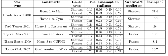
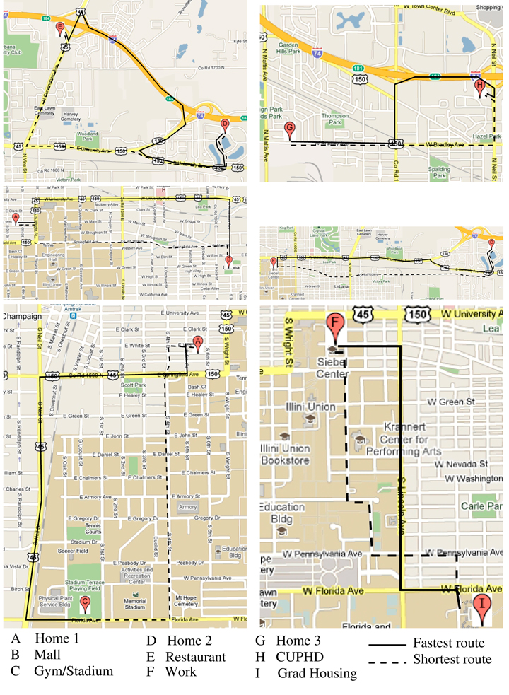


 Nation’s Senior Space Warfighters