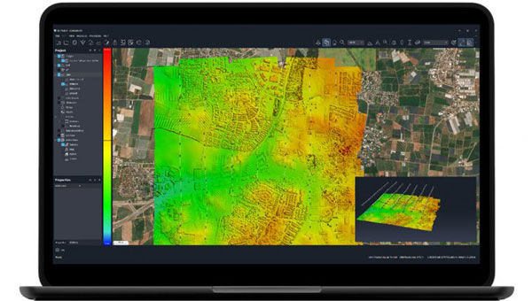
SimActive has released upgraded cloud capabilities for its Correlator3D mapping software. With its distributed processing capabilities, Correlator3D allows users to scale their processing to match individual operational needs.
With the upgrade, Correlator3D can process large mapping projects and deliver results from UAV, aircraft and satellite imagery. It features a software package – a patented, end-to-end photogrammetry solution — designed to generate high-quality geospatial data from a variety of sources, including satellite and aerial imagery and UAVs. The upgrade aims to improve the technology’s performance in diverse cloud scenarios.
Correlator3D is designed to provide aerial triangulation (AT) and generate dense digital surface models (DSM), precise digital terrain models (DTM), point clouds, orthomosaics, 3D models and vectorized 3D features. By using GPU technology and multi-core CPUs, Correlator3D offers enhanced processing speed to support the rapid production of large datasets.
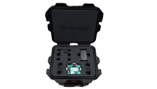
UAV Navigation-Grupo Oesía has released its GNSS-denied navigation kit designed to offer navigation capabilities in challenging environments.
The kit combines UAV Navigation’s attitude and heading reference system (AHRS), the POLAR-300, with its Visual Navigation System, the VNS01, designed to offer unmatched dead reckoning navigation capabilities with minimal drift.
The technology offers users improved navigational accuracy, with error rates as low as 0-1% over covered distances. This is made possible by the kit’s visual-based technology, which allows for precise attitude and position estimation to stabilize flights in challenging conditions. The kit is equipped with advanced algorithms that can detect and counter sophisticated spoofing and jamming techniques to offer reliable and secure navigation, even in the face of potential signal disruptions.
As technology advances and geopolitical challenges emerge, the demand for reliable and secure navigation for UAVs intensifies. Offering operational integrity in both the civil and defense sectors is paramount, especially with the rise of disruptive systems designed to interfere with radio-electronic navigation and communication.
Earlier this week House Intelligence Committee Chair Mike Turner sounded an alarm about a serious national security threat. It had to do with Russia, a weapon, space, and something nuclear.
For many, these clues conjured up images of bombs falling to Earth from space, satellites destroyed by powerful electromagnetic pulses, shrapnel impacting the space station, and so on.
Yet, putting nuclear weapons in space would be a clear violation of the 1967 Outer Space Treaty to which Russia and the United States are both signatories. It would also significantly increase East-West tensions at a time when Russia has enough tension and international condemnation to handle.
Thursday evening the White House calmed the waters a bit by saying that Russia was pursing an anti-satellite weapon that cannot cause physical destruction on Earth.
The most reasonable conclusion to draw from all of this is that Russia is closing in on its goal of having a nuclear-powered electronic warfare capability in space.
Such a reusable weapon could be far more useful than any one-use nuclear explosive device.
“There is strong evidence from publicly available sources that a Russian company called KB Arsenal is working on a new type of military satellite equipped with a nuclear power source. Called Ekipazh, its mission may well be to perform electronic warfare [EW] from space.”
The author, Bart Hendrickx, goes on to explain that development of such a weapon would be entirely in keeping with reported Russian government plans. Citing one Russian language source he says:
“… the deployment of EW platforms in orbit would be in accordance with a policy for Russia’s electronic warfare program until 2020 approved by the Russian government in January 2012. A summary of this policy indeed mentions space-based electronic warfare as one of the objectives to be accomplished in the period before 2025. More specifically, it talks about the need to deploy ‘multifunctional space-based EW complexes for reconnaissance and suppression of radio-electronic systems used by radar, navigation and communications systems.’”
When intelligence agencies assess the severity of a particular threat, they look at an adversary’s desire or intent to carry out a particular act, and their capability to do so. If the reporting is correct, Russia has intended to put a nuclear-powered EW satellite or spacecraft in orbit for some time. This week’s political dust up may mean that the decades of hard work described by Hendrickx in Space Review have paid off and given them the ability to do so.
More Useful Than Orbiting Bombs
The United States is far more dependent upon space than any other nation. As regular GPS World readers know, this is especially true for the essential positioning, navigation, and timing services that underpin virtually every technology.
Destroying satellites would quickly lead to a shooting war that no one would want.
On the other hand, electronic warfare doesn’t necessarily lead to casualties right away and is harder to recognize as actual warfare. For example, Russia has been attacking NATO countries, ships, and aircraft in the Baltic with GPS jamming and spoofing on and off since mid-December. No one has died (yet) and NATO, to the best of our knowledge, has not responded.
Rather than destroying satellites, how much more useful is it to be able to temporarily disrupt the operation of one or more satellites? Or perhaps one type of satellite, such as GPS?
Such attacks are reversable, so the attacked party is less likely to send bombs and bullets in return right away. And if the attacker gets what they want, or suddenly discovers they have gone a bit too far and are approaching a kinetic exchange, backing off is as easy as flipping a switch.
Just the threat of being able to deny GPS or other satellite signals over a wide area would be useful.
In fact, Russia has already made this kind of threat and it didn’t backfire.
In November 2021, prior to its invasion of Ukraine, Russia used a ground-based missile to destroy one of its own defunct satellites. Shortly thereafter Russian state-sponsored media claimed the demonstration “… means that if NATO crosses our red line, it risks losing all 32 of its GPS satellites at once.” Aside from a strong diplomatic tongue-lashing, there were few consequences. Additionally, wherever the “red line” was, it seems that NATO did not cross it.
Nuclear Powered EW Most Likely
It’s hard to know what more will be revealed, if anything, about this week’s dust-up over Russia, weapons, space, and nuclear.
It is highly likely that Russia is executing its plans to extend this prowess and advantage into space with a nuclear-powered EW satellite.
Whether or not this is the root Washington’s kerfuffle, the possibility should be an on-going concern for the United States.
Our dependance on space makes us vulnerable. Our critical over-dependence on space for PNT, especially in light of the terrestrial PNT alternatives available to Russia and China, exposes our jugular and virtually invites attack.
We have placed most of our eggs in the same basket — and there are too many ways in which it can be knocked to the ground.
Until the United States establishes a resilient national PNT architecture, one with GPS at its center supported by other diverse and robust sources, we will continue to unintentionally encourage such things as space-based nuclear-powered electronic warfare and be at severe risk.
The United States Department of Justice (DOJ) has filed to dismiss satellite communications firm Ligado Network’s October 2023 lawsuit against the federal government, arguing that the court does not have jurisdiction and the company’s claims have no legal basis.
Ligado’s $40 billion suit alleged that officials at the U.S. Department of Defense (DOD) took “unlawful actions” to, in effect, improperly seize the firm’s L-band spectrum without compensation. Ligado was granted to build a 5G communications network by the Federal Communications Commission (FCC) in 2020.
Ligado plans to use the L-band spectrum — normally used by satellites — to develop a wireless cell phone network. However, the DoD, and several other federal agencies, including the Department of Transportation (DOT), have expressed concerns that Ligado’s terrestrial operations could have harmful effects on GPS.
According to Ligado, as long as the DOD continues to use the spectrum, Ligado will be unable to use it to launch its terrestrial communications services.
The DOJ’s motion asserts that rather than the U.S. Federal Claims Court, the issue instead falls under the jurisdiction of the Federal Communications Act, which “established a comprehensive remedial scheme” for FCC licensing decisions.
Secondly, the motion says Ligado’s complaint “fails to allege any authorized government actions that could give rise to takings liability, and instead, it contends that the government has been engaged in an unlawful effort to preclude Ligado from using its FCC license. These contentions necessarily preclude any takings liability.”
The motion goes on to contest each of the Ligado suit’s four specific legal claims. The DOJ alleges, “Ligado fails to plead any plausible facts to support its purely speculative claim that the government has occupied its licensed spectrum. And its theory that the government required a spectrum ‘dead zone’ around the separate spectrum bands allocated for GPS use similarly fails because Ligado cannot identify any authorized government action that precluded it from actually using its modified license.”
In response to the motion, Ligado provided a statement to Breaking Defense, reiterating its complaint that government officials deliberately deprived Ligado of its rightfully licensed property and must be held accountable.
“This attack on an American business by the world’s most powerful institution is contrary to the rule of law and antithetical to the government’s years-long support for the deployment of 5G technology as a vital national priority,” the statement said. “We worked diligently and in good faith with government agencies to find a fair resolution but were left with no choice but to pursue litigation to defend our interests. We continue to stand firmly behind our complaint and will reply to the government’s motion in the appropriate forum.”
Geely, a Chinese automaker, has launched its second set of low-Earth orbit (LEO) satellites in its effort to enhance navigation capabilities for autonomous vehicles. The 11 satellites were launched from the Xichang Satellite Launch Center in Sichuan, China province.
According to Geely, the company aims to have 72 satellites in orbit by 2025. The long-term goal is to establish a constellation of 240 satellites to create a comprehensive satellite network for various applications.
Geely’s satellite network is designed to provide high-precision positioning support for autonomous vehicles. By using satellite technology, the company aims to enhance navigation accuracy to enhance safety and efficiency on the roads.
The newly launched satellites are equipped with artificial intelligence (AI) remote sensing capabilities, which allows them to capture clear high-resolution imaging. With a resolution ranging from 3.2 ft to 16.4 ft, these satellites can provide valuable data and imagery for multiple applications, including surveillance, urban planning and infrastructure management.
China’s satellite industry has seen a significant surge in commercial activities since the government allowed private investment in the space sector. With supportive policies and investments, numerous commercial companies, including Geely, have ventured into satellite manufacturing and launch vehicles.
“Seen & Heard” is a monthly feature of GPS World magazine, traveling the world to capture interesting and unusual news stories involving the GNSS/PNT industry.
According to the 2023 Arctic Report Card by the National Oceanic and Atmospheric Administration (NOAA), new records have been documented showing that human-induced warming of the atmosphere, ocean and land is creating adverse impacts on people, ecosystems and communities across the Arctic region. The report states the Arctic is experiencing a faster rate of warming than any other part of the world. Overall, it was the Arctic’s sixth-warmest year on record. Sea ice extent continued to decline, with the past 17 Septembers now registering as the lowest on record.
Researchers from Chang’an University in China have developed a new method of tracking landslides. The team combined GNSS precise point positioning (PPP) techniques with a cumulative sum control chart (CUSUM) method. Conducted at the Tengqing landslide in Liupanshui, Guizhou Province, Southwest China, the study aims to enhance the precision in tracking the movements of the landslides and improve the overall reliability of the monitoring results.
Crabs on the move
Image: United States Geological Survey (USGS)
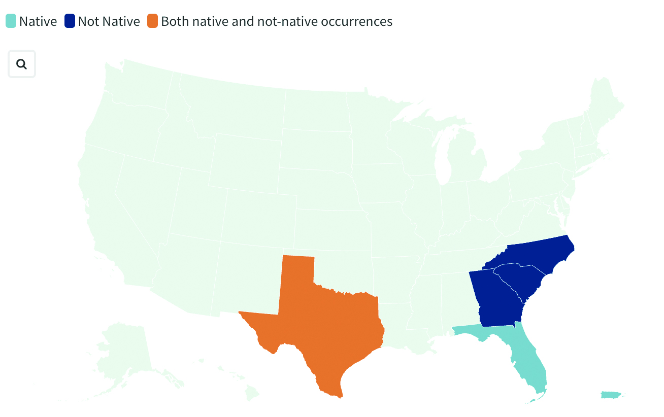
Georgia officials are asking the public for help in spotting non-native blue land crabs as they appear to be moving north in recent years, according to data collected by the United States Geological Survey (USGS). According to USGS, it is unclear whether this movement is driven by humans or by the crabs themselves, or if the crabs are breeding in their non-native homes. Officials worry about the damage caused by the crabs’ burrowing behavior. While scientists learn about how the species interacts with its new environment, several states are asking residents to report sightings.
India’s war on drugs
Image: evandrorigon / E+ / Getty Images
India’s border security force (BSF) has said it is battling an unprecedented UAV “menace” infiltrating the border with Pakistan, fueling the drug crisis in the state of Punjab and raising serious security issues, reported The Guardian. UAVs have dropped weapons such as pistols and Chinese-made assault rifles, as well as consignments of opium and heroin believed to be from Afghanistan.
New GPS ground stations that are contracted by Raytheon Technologies to replace the current ground stations have been delayed until July 2025, the Pentagon’s testing office reported.
The Next Generation Operational Control System (OCX) is facing a new delay of 16 months, according to the 2023 Annual Report of the Director of Operational Test & Evaluation (DOT&E).
More than seven years behind schedule, the continuous delays have caused the U.S. Department of Defense (DOD) to go over its yearly budget and have sparked discussions as to future budget allocations for the U.S. Space Force (USSF) to continue to control and enhance the GPS constellation.
“These delays increase the risk that U.S. and allied warfighters will be unable to conduct successful operations in future contested environments due to the lack of access to modernized GPS position, navigation, and timing (PNT) information,” the Pentagon’s testing office said in a statement.
The M-Code can now be broadcast on 21 of the 31 GPS satellites in orbit. However, it is only available to a small number of military personnel due to both the OCX issue and a lack of radios and receivers equipped to access it.
The Space Force has a Military GPS User Equipment (MGUE) program underway to develop new computer chip-carrying cards to retrofit existing platforms, such as aircraft and ships, so they can ingest M-code signals, as well as to develop a new handheld receiver. This effort has also experienced delays, according to a June 2023 report by the Government Accountability Office.
The 2024 DOT&E report notes that because of the delays in the development of the MGUE receiver cards, the Army and Marine Corps are now buying commercially developed receivers capable of ingesting the M-Code for fielding with ground vehicles.
Additionally, the DOT&E report cautions that because the OCX software is designed to be the basis for an upgraded system, OCX Block 3F, designed to control the planned next generation of GPS satellites called GPS IIIF, that effort also is likely to be delayed. The Space Force intends to launch the first GPS IIIF satellite in 2027.
Intecs, a hardware and software developer, is creating a multi-sensor, GNSS-based platform for obtaining absolute position of trains on rail lines. The system incorporates cameras that read QR codes installed in the area adjacent to the track. The system includes a robust, software-based, data fusion engine that combines GNSS and visual data to determine train position.
The delay when a train loses its position can be significant and affect other vehicles on the rail lines. The Intecs system — assisted GNSS with imaging sensors for rail applications (AGIS4RAIL) — can correctly identify the position of a vehicle.
Test campaign
Numerous field tests have been conducted for the new system. One of the most critical sets of trials was carried out on an auto racing track. The trial involved a ground vehicle with GNSS antennas positioned on the roof and with cameras pointing to the side where QR code panels were set up at 10 m intervals. The vehicle was driven for 30 laps around the course under various conditions. AGIS4RAIL correctly identified the position of the vehicle at every lap, with the vehicle achieving a maximum speed of 35 km/h. The maximum estimated error was 4.76 m, which is in line with the target of 5 m.
Imaging sensors help to reduce the negative impact of various local effects on positioning systems that rely solely on Global Navigation Satellite Systems (GNSS), such as multipath errors. The AGIS4RAIL system also offers protection against jamming and spoofing. Additionally, the QR-code landmarks can contain data to verify the authenticity of the landmark itself.
Further testing continues and will soon include trials onboard operational trains in Italy, according to Intecs. The AGIS4RAIL project received funding under the European Space Agency’s Navigation Innovation and Support Program (NAVISP).
Every day, the Federal Aviation Administration (FAA) monitors and assists more than 45,000 flights — up to 5,000 at any one time — across the more than 29 million square miles that make up the U.S. National Airspace System (NAS). It knows the position of each plane with an accuracy well within its length.
Three key NAS systems are the Automatic Dependent Surveillance-Broadcast (ADS-B), the Airport Surveillance Radar (ASR-11), and the Wide Area Augmentation System (WAAS). They are all part of the Next Generation Air Transportation System (NextGen), a large-scale FAA initiative to modernize the NAS.
ADS-B — which includes ground-based radar and navigational aids and GNSS signals — provides real-time precision, shared situational awareness, and advanced applications for both pilots and air traffic controllers. It enables pilots to see on their cockpit displays what controllers see: other aircraft in the sky.
Relying on satellites instead of ground navigational aids also enables aircraft to fly more directly between airports, reducing flight times, fuel consumption, and air pollution. Furthermore, the improved accuracy, integrity and reliability of satellite signals over radar will enable air traffic controllers to safely reduce the minimum separation distance between aircraft, thereby increasing the number of flights.
ASR-11 is an integrated primary and secondary radar system at terminal air traffic control sites. It interfaces with both legacy and digital automation systems and provides greatly improved local weather forecasts that enhance situational awareness for both air traffic controllers and pilots.
WAAS, a form of a satellite-based augmentation system (SBAS), enables the NAS to provide horizontal and vertical navigation for approach operations for all classes of aircraft in all phases of flight, including vertically-guided landing approaches in instrument meteorological conditions at all qualified locations. It may be further enhanced with ground-based augmentation systems (GBAS) in critical areas.
Through NextGen, the FAA has modernized air traffic infrastructure in communications, navigation, surveillance, automation, and information management with the aim of increasing the safety, efficiency, capacity, predictability, flexibility, and resiliency of U.S. aviation. NextGen includes airport infrastructure improvements, new air traffic technologies and procedures, and safety and security enhancements.
Now, contrast all this with the near inability of the Federal Railroad Administration — tasked with enabling the “safe, reliable, and efficient movement of people and goods” by rail across the United States — to track any of the trains that carry 28 percent of the country’s freight, including many hazardous materials, and to know what they contain. In 2023, there were more than 1,000 train derailments in the United States, most of them in railyards. The derailment in East Palestine, Ohio, a year ago, caused more than $800 million in damages and 80 percent of residents experienced health consequences. Only luck has so far prevented massive loss of life due to a derailment in an urban area. True, the FRA’s operating environment, which includes tunnels and multipath, is very different from the FAA’s, as are its regulatory challenges. Still, tracking where trains are and what they carry would be a great start to addressing the threat of toxic spills.
For centuries before sonar, lidar and unmanned surface vehicles (USVs), sailors would measure depths by throwing a line overboard with a lead weight at the end — called a leadline — and record its length to the seafloor. Mapping large areas of the seafloor, therefore, required thousands of these measurements.
However, even after extensive measurement efforts, the acquired data was often inaccurate or incomplete, which forced navigators and surveyors to estimate the seafloor’s bathymetry until remote sensing was introduced in the 1970s.
Since then, the growing need for increasingly accurate and rapidly available data has led to a worldwide effort to develop sensors and alternative techniques for measuring depths.
In the ongoing Florida Seafloor Mapping Initiative (FSMI), the Florida Department of Environmental Protection tasked Woolpert Geospatial Program with acquiring bathymetric survey data using lidar technologies to produce a comprehensive, publicly available, high-resolution seafloor surface model of Florida’s coastal waters by 2026.
Similar initiatives across the globe have kick-started innovations in underwater data collection and interpretation. In this feature, SBG Systems, CHC Navigation (CHCNAV) and Advanced Navigation describe how they used modern hydrographic surveying to aid defense departments, produce 3D topographic maps, and analyze the depth of The Great Blue Hole in Belize.
Exploring challenging waters
SBG Systems
Advancements in hydrographic surveys can lead to the exploration of depths previously unknown. The Great Blue Hole, located off the coast of Belize, is the largest marine sinkhole in the world, with a diameter of 300 m and a depth of 125 m. This major scuba hotspot is part of the Belize Barrier Reef Reserve System and a UNESCO World Heritage Site.
Aquatica Submarines conducted an expedition survey of the Blue Hole. For two weeks, a team of scientists, explorers, and filmmakers collected survey data and captured photos and videos of this geological wonder. It is the first time in history that an expedition of this scale was attempted at the Blue Hole.
The challenge: Finding submersibles to equip with sonar
The expedition team chose two submarines to carry out the survey: its Stingray 500 and the Roatan Institute of Deepsea Exploration’s IDABEL. Both vessels can carry up to three persons for a maximum of 12 hours.
Norwegian technology group Kongsberg’s dual-axis sonar technology was used to create a 3D representation of the sinkhole. The surface and submarine-mounted sonar equipment were also equipped with SBG Systems’ Ellipse miniature inertial navigation system (INS).
The Ellipse was used to mark the Blue Hole perimeter and scientists then processed the recorded data using MS1000 processing software.
Additional steps and results: Analyzing 3D sonar maps
A key outcome of the expedition is the creation of a complete 3D sonar map of the Blue Hole using point-cloud data collected by Kongsberg’s dual-axis sonar to create a 3D map of the site. The sonar was pole-mounted on the survey vessel with the GPS receiver and motion reference unit directly over the scanner’s head.
Sonar expert Mark Atherton from Kongsberg’s Canadian subsidiary, Kongsberg Mesotech, was a key member of the science-based sonar and data collection team. Atherton operated the sonars aboard the Research Vessel Brooks McCall, contributing to an invaluable high-resolution map of the entire sinkhole.
“By understanding the geological history and geometric structure at the Blue Hole, we can contribute new data to the global scientific community studying sinkholes and cenotes,” Atherton said.
The team was able to conduct more than 20 dives into the large sinkhole, taking videos and 3D images during each trip. They also completed a two-hour live broadcast featured on The Discovery Channel.
“What [the Great Blue Hole] tells us is that sea level rise is not [always] a gradual process,” said Erika Bergman, Aquatica’s chief pilot and oceanographer. “We carefully measured the terraces and layers built up in the hole and we can see that sea level rise can happen dramatically.”
Producing 3D hydrodynamic models
CHC Navigation
Flood control structures — such as dikes, dams, spurs, drainage channels, and floodways — are designed to protect coastal and riverine areas of cities and farms and, above all, the people who live there.
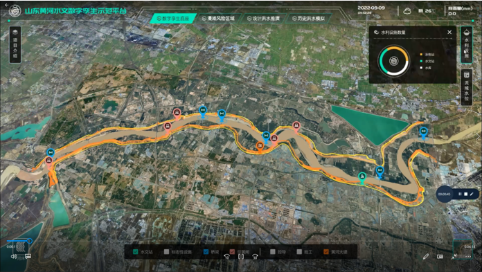
To prevent flooding in low-lying regions and support national ecological protection and development strategies in the Yellow River Basin in China, the Ministry of Water Resources launched the “Digital Twin Yellow River Construction Plan (2022-2025)” project. The Chinese Bureau of Hydrology and Water Resources was tasked with building a digital twin flood model based on part of the country’s Yellow River, targeting the 28-km section of the river basin.
The challenge: Building and designing a digital twin flood model
The first step was to acquire 3D data underwater, on land, and from the air. CHC Navigation (CHCNAV) provided its Apache 6 and Apache 4 USVs to collect underwater data using multi-beam and single-beam echo sounders. The AlphaUni lidar system mounted on the BB4 UAV was used to gather the land data. Finally, the team obtained aerial data using an oblique photographic system from CHCNAV mounted on a UAV.
As a result, researchers obtained large-scale remote sensing images, laser point clouds, terrain data, oblique photography, CAD drawings, and BIM models.
The simulation and analysis of the historical flood events on the third party software; based on the data collected by CHCNAV’s USV and UAV. (Image: CHCNAV)
CoPre software, a 3D laser scanning pre-processing software that can process captured raw data, including POS trajectories, lidar data, and RGB images, was used for the Tilt and DOM modeling.
CoProcess software, designed for reality capture post-processing tasks and DEM/DTM generation, generated high-precision DEM models, a 3D representation of a ground surface created from elevation data, with a point cloud density of more than 50 points/m2 for the areas above and below the water.
Additional steps
The remotely operated vehicles and generated models obtained site data such as climate records, flood maps, flow records, hydrologic summaries, groundwater level records, water quality, and resource data to use as the basis of the analysis.
The team also used historical flood information during the scoping phase to develop a conceptual model of the flood mechanisms. Based on the actual flood records, a third-party flood simulation platform was used to produce the entire flood process for the different years.
The real-time flood extrapolation was processed on the third-party software, which simulated steady and unsteady flow patterns using hydrodynamic modeling algorithms.
“Advancements in bathymetric surveying, incorporating cutting-edge technologies such as UAVs with lidar, USVs with echo sounders, and high-precision positioning systems, have transformed the creation of digital twin models for water bodies, particularly the Yellow River in China,” said Taxiya Wang, Business Development Manager of Marine Survey at CHC Navigation. “This bathymetric surveying effort has laid the foundation for hydraulic models, flood maps, and customized applications, emphasizing the importance of up-to-date, high-quality data in watershed engineering and construction projects.”
The result
Based on the developed digital flood model, the next step for the digital watershed twin project is to collaborate with technical staff, experts, and users to create customized applications for watershed engineering and construction. The project is ongoing and will end in 2025.
Surveying wet gaps
Advanced Navigation
Defense departments are continuously looking to improve the safety of military personnel and equipment in conflict regions. With this aim, the UK Defense Science and Technology Laboratory (DSTL) launched its “Map the Gap” competition. It invited engineering firms to design and build an unmanned surface vessel (USV) capable of quickly, reliably, and safely surveying wet gaps — including rivers, streams, canals, and waterways — without putting engineers and other personnel at risk. Commanders can then view the survey data to determine the safest crossing points for troops and equipment.
DSTL relied on Advanced Navigation’s Spatial FOG Dual fiber optic gyroscope to conduct the hydrographic surveying project.
The challenge: Building a USV to assist defense forces
Challenges in the project included measuring water depths and flow rates, crossing lengths, river-bed topography, and riverbank heights, as well as shape profiling and assessing ground load handling capabilities. The vehicles also had to be either remotely operated or fully autonomous and deliver the collected data in a way that could be easily interpreted for quick decision-making.
The survey required multiple sensor technologies for simultaneous above- and below-water 3D surveys. For above-water use, dual lidar sensors produce high-resolution point clouds of the surrounding environment. For below-water mapping, a sensor suite consisting of a multibeam sonar, an Acoustic Doppler Current Profiler/Doppler Velocity Log (ADCP/DVL), and a cone penetrometer were used to measure current and water flow as well as to test substrate density.
Ultrabeam Hydrographic won the DSTL competition. Its team integrated multiple sensors into a single housing and selected the four-wheeled Axolotl vehicle for the second phase of the project.
Additional steps
An example of the highly detailed single-3D survey output from the Axolotl, showing features both above and below the water. (Image: Advanced Navigation)
The team was in search of a GNSS/INS device capable of dead-reckoning and maintaining accurate heading for extended periods of time, which led them to Advanced Navigation’s Spatial FOG Dual GNSS/INS.
Ultrabeam Hydrographic had previously been using a MEMS-based solution that could maintain a suitably accurate heading without GNSS for up to approximately 60 seconds. However, tests with the Spatial FOG Dual showed that it could maintain an accurate heading for more than 15 minutes.
“The MEMS can hold onto heading for maybe 30 seconds to a minute, accurately. After that, it’s not reliable,” Gabriel Walton, Ultrabeam Hydrographic’s technical director said. “We have used the Spatial FOG Dual in certain circumstances where we went 10 to 15 minutes without GNSS. I do believe it will go on for longer.”
The team integrated the Advanced Navigation solution into their survey management and mission control software. This allowed the Spatial FOG Dual to be used for survey purposes and to provide motion data to the robot’s artificial intelligence (AI) for autonomous mission control and object detection and avoidance.
The result
“Map the Gap” Phase 2 demonstrated that the Axolotl’s mechanical design, sensor suite integration, extensive use of AI for autonomous mission control, decision-making and precise navigation can serve as a significant advancement for bathymetric surveying.
Since “Map the Gap,” Ultrabeam Hydrographic has deployed the Axolotl on commercial waterway survey missions, such as surveying bridge sites and attaining a clear understanding of riverbed and water conditions.
The U.S. Space Systems Command (SSC), part of the United States Space Force, is actively seeking insights from the GNSS industry through a Request for Information (RFI) regarding the development of a Global Positioning System (GPS) Rapid Prototype Demonstration, Tranche 0.
This initiative is part of a strategic effort to upgrade GPS capabilities to meet modern challenges in space navigation and ensure continued operational superiority. This RFI aims to collect information about the industry’s capacity to innovate and deliver solutions that can enhance the GPS infrastructure. The focus is on identifying technologies and approaches that can reduce the size, weight, power and cost (SWaP-C) of future GPS satellites, streamline their production and launch processes and improve compatibility with a variety of launch vehicles.
According to the SSC, the goal of Tranche 0 is to create a prototype satellite that can emit certain GPS signals that are compatible with existing user equipment. The operation of this prototype in medium-Earth orbit (MEO), approximately 20,000 km above Earth, aims to test and validate these innovations in a real-world setting. The SSC’s approach aims to encourage collaboration, inviting both established and emerging players in the industry to showcase their abilities in rapid development, fabrication, and integration of GPS payloads.
Respondents to the RFI are reminded to adhere to security protocols to ensure that all submissions are unclassified, though they may include Controlled Unclassified Information (CUI) if properly marked. The SSC has also provided references to essential GPS Interface Control Documents (ICDs) and performance standards.
The Volpe National Transportation Systems Center of the U.S. Department of Transportation (DOT) has issued a solicitation to obtain proposals from vendors with operationally ready complementary positioning, navigation and timing (CPNT) services to be used for testing and evaluation in the Rapid Phase of the DOT’s CPNT Action Plan.
The Volpe Center is seeking proposals from industry professionals to deploy PNT services with a technical readiness level (TRL) of eight or higher.
The evaluation conditions will include situations where GPS/GNSS service is disrupted or manipulated, and CPNT‐specific threat vectors are introduced. Proposals are encouraged to be tailored to critical infrastructure PNT user requirements with the expectation that Rapid Phase evaluation results will be shared with sector risk management agencies (SRMAs) through the Federal interagency process to drive CPNT adoption.
According to the Volpe Center, it is prepared to make multiple awards if multiple proposals meet the solicitation requirements.
Responses to the request for quotation (RFQ) should include the bidder’s preferred test range model(s) out of the following three proposed models, where the proposed CPNT service can quickly become operationally ready to meet the Rapid Phase timeline objectives — no later than six months after award:
Federal Government‐hosted test range
Critical infrastructure test range
Vendor-fielded test range
Offers are due March 25, 2024. Click here for more information.