The U.S. Department of Transportation (DOT) has approved $2.5 billion worth of bonds to help fund the Brightline West high-speed rail project connecting Las Vegas, Nevada, and Southern California.
The 218-mile line, estimated to cost $12 billion in total, will run along the I-15 median with electric trains capable of running at 186 mph.
The DOT previously approved private activity bonds of $1 billion for the project in 2020. The second tranche of private activity bonds brings the total to $3.5 billion. In December 2023, the DOT also awarded a $3 billion grant from President Biden’s infrastructure law to the Nevada DOT for the project.
In June 2023, DOT awarded a $25 million grant to San Bernardino County Transportation Authority (SBCTA) through the Rebuilding American Infrastructure with Sustainability and Equity (RAISE) Program to be used for the construction of the Brightline West stations in Hesperia and Victor Valley, California.
Brightline West is expected to break ground in early 2024.
Three U.S. service members were killed and dozens wounded during a UAV attack on U.S. forces stationed in northeastern Jordan near the Syrian border, President Joe Biden and U.S. officials said on January 28.
Biden blamed Iran-backed groups for the attack, the first deadly strike against U.S. forces since the Israel-Hamas war erupted in October 2023 and sent shock waves throughout the Middle East.
“While we are still gathering the facts of this attack, we know it was carried out by radical Iran-backed militant groups operating in Syria and Iraq,” Biden said in a statement.
At least 34 personnel were being evaluated for possible traumatic brain injury, a U.S. official told Reuters, speaking on the condition of anonymity. Two officials said some wounded U.S. forces were medically evacuated from the base for further treatment.
The Islamic Resistance in Iraq – an umbrella organization of Iran-backed militant groups — claimed attacks on three bases, including one on the Jordan-Syria border.
The attack is a major escalation in the already tense situation in the Middle East, where war broke out in Gaza after the Palestinian Islamist group Hamas attacked Israel on October 7, killing 1,200 people. Israel’s subsequent assault on Gaza has killed more than 26,000 Palestinians as of January 2024, according to the local health ministry.
Since then, U.S. forces have come under attack more than 150 times by Iran-backed groups in Iraq and Syria. U.S. warships have also been fired at by Iran-backed Houthi forces in Yemen, who are regularly attacking commercial ships passing through Red Sea waters off Yemen’s coast.
While the United States has maintained an official line that Washington is not at war in the region, it has been retaliating against the Iran-backed groups in Iraq and Syria and carrying out strikes against Yemen’s Houthi military capabilities.
Referring to the fallen soldiers, in his statement released by the White House Biden said: “We will carry on their commitment to fight terrorism. And have no doubt — we will hold all those responsible to account at a time and in a manner of our choosing.”
A street in Pompeii shows the structures that were remarkably preserved after Mount Vesuvius covered the city in ash in 79 CE. Everything about Porta Nocera, Region I 14 is being digitized by archaeologists. (Image: Allison Emmerson)
At the edge of Pompeii, along a city gate known as the Porta Nocera, professor Allison Emmerson of Tulane University directs a team of archaeologists. The famous Roman city, frozen in time when Mount Vesuvius erupted and covered it with ash, continues to reveal new insights to archaeologists nearly 275 years after the site was first discovered.
Within a building long believed to be a home around 2,000 years ago, the team unearthed a different story — one unraveling traces of economics, urban design, and social life among an elite and a lower class. To tell the story, Emmerson and her team have created a location-aware digital twin of the excavation site, which incorporates 2D maps, smart maps, and 3D models. The team is also able to share live data via a fully digital workflow using iPad Pros and Apple Pencils.
Revolutionary documentation with mobile app workflows
The latest geographic information system (GIS) technology allows Emmerson’s team to digitize everything they unearth at Porta Nocera, Region I Insula 14 as part of the Pompeii I.14 Project run by Tulane.
The team first used UAV imagery, terrestrial photography, and a technique called structure-from-motion photogrammetry to create a base map and 3D base model of the site. They then used tablets loaded with GIS apps to layer data over that 3D base model.
Leading the GIS data collection workflow is professor Alex Elvis Badillo, cohead of the project’s digital data initiatives team. Badillo said the archeologists use GIS documentation on the iPad Pro to record and explore data in layers to avoid information destruction.
Using ArcGIS Survey123, the team can share data on-site and implement paperless workflows. That data can also be linked to digital ArcGIS Dashboards to keep track of progress and foster collaboration during the excavation.
Interpreting the dig site
Emmerson and her team determined that the structure they initially uncovered was used for commercial activity such as shopping and dining, often identified with the lower classes at the time. Meanwhile, an elite residence was located right next door and the two buildings shared resources.
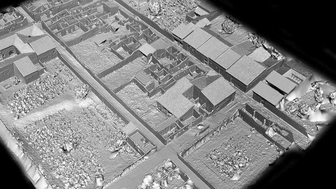
Lidar (light detection and ranging) uses laser light to densely sample the surface of the Pompeii I.14 site, producing highly accurate x,y,z measurements that provide the foundation for the digital twin. (Image: Allison Emmerson)
The Pompeii I.14 Project is ongoing. Once it is complete, the data will be incorporated into a larger digital twin from the Pompeii Bibliography and Mapping Project (2017) led by Eric Poehler, an associate professor of Classics at the University of Massachusetts Amherst. It will also be added to Pompeii’s central archaeology database and be available to policymakers, educators, archaeologists, and the public.
Researchers hope that a new understanding of the economic and social life of an ancient city such as Pompeii can not only inform us about the past but also help us create a better future.
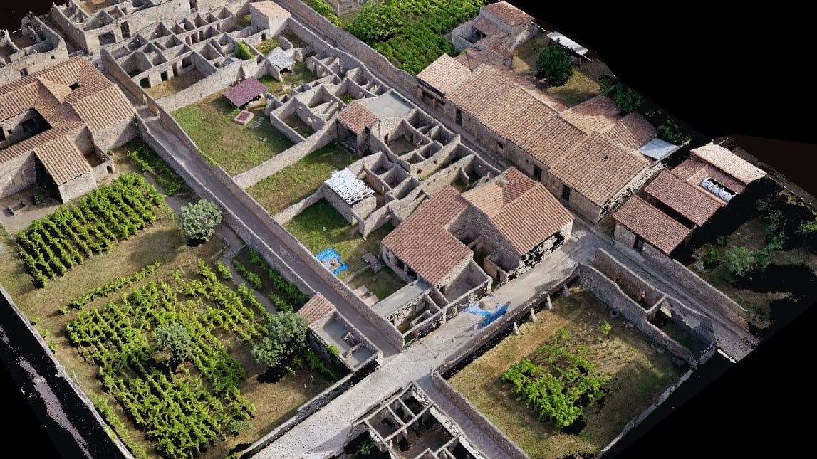
UAV imagery draped over the lidar data provides a photorealistic surrogate of the Pompeii I.14 Project site, which serves as the centerpiece for project data collection. (Image: Allison Emmerson)
DJI has launched DJI Modify, its first intelligent 3D model editing software.
The solution can be integrated seamlessly with DJI’s enterprise UAVs and 3D modeling and mapping software, DJI Terra. When integrated with these products, the software can be used for aerial surveying, transportation and emergency responses.
Seamless workflow with DJI Terra
DJI Modify paired with DJI Terra offers users an end-to-end solution from modeling to model editing. Once DJI Modify has been enabled, DJI Terra files for model editing are automatically generated, including pre-identified objects and pre-processing of the model. It is designed to make repairing common 3D model defects seamless and efficient. As of early 2024, DJI Modify will only support repairing models built by DJI Terra.
Efficient 3D model editing
DJI Modify allows for model files to be quickly imported and exported to the DJI Terra and other third-party software. In the future, processed models can be shared to the cloud for online viewing and sharing via links without software installation, DJI said.
DJI Modify’s intelligent auto-repair editing supports flattening, editing textures, repairing water surfaces, removing floating parts, and filling holes. Edits can be made using one-click repairs or manually by selecting custom polygons, areas or meshes.
The software’s smoother model display technology allows high- and low-quality models to be viewed and edited in a single interface. Changes made can be synchronized across both models and previewed immediately, which allows users to address model editing issues in real-time.
ComNav Technology has introduced its new handheld P6H solution. The device is designed for GIS data collection and outdoor operations. Featuring a GNSS high-precision positioning module, rugged IP67-rated design, and 6-inch sunlight-readable display, the P6H offers positioning accuracy even in harsh environments.
Equipped with a SinoGNSS self-developed high-precision K8 board and antenna, it can track all running and planned constellations with 1,590 channels, including GPS, BDS, GLONASS, Galileo, QZAA, IRNSS and SBAS.
The P6H offers users centimeter- or decimeter-level accuracy. Its IP67 rating protects against dust and water to enhance its efficiency and durability in tough environments.
The device comes equipped with Survey Master, boasting robust GIS functions, which allows users to take measurements of geographic elements and store the results as attribute data for subsequent analysis, calculation and visualization. It also includes a mock location function for users to accurately share Survey Master’s position with P6H. The location data can then be accessed on a third-party GIS software.
It is also compatible with common GIS software such as ArcGIS Collector, Mapit GIS and QGIS. Additionally, the P6H features an 8-core 2.0 GHz processor, up to 128 GB of storage and up to 6 GB of RAM to offer users smooth software operation and efficient data processing.
The handheld device, featuring a high-precision GNSS module and antenna, also incorporates 4G LTE, Wi-Fi and Bluetooth to improve its data transmission and sharing capabilities.
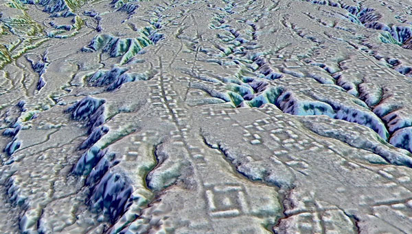
A lidar map of the city of Kunguints in the Ecuadorian Amazon reveals ancient streets lined with houses. (Image: Antoine Dorison and Stephen Rostain)
Archeologists have discovered a vast and highly complex system of ancient cities dating back nearly 3,000 years in the Amazon rainforest. Complete with a complex network of farmland and roads, the discovery is the oldest and largest of its kind in the region.
Located in Ecuador’s Upano Valley, the structures lie in the eastern foothills of the Andes mountains, according to a study published in the journal Science. After more than 20 years of research, the ancient urban centers were only discovered when the Ecuadorean government employed lidar technology.
“I have explored the site many times, but lidar gave me another view of the land,” archaeologist Stéphen Rostain, lead author of the study and director of research at the French National Center for Scientific Research (CNRS), told Live Science. “On foot, you have trees in the way, and it’s difficult to see what’s actually hidden there.”
A team of researchers from France, Germany, Ecuador and Puerto Rico conducted a lidar survey that covered roughly 300 km2. The survey revealed a landscape full of organized human activities, including more than 6,000 rectangular earthen platforms, as well as agricultural terraces and drainage systems.
According to the study, these structures formed at least 15 distinct settlements, which were connected by a system of wide, straight roads. Co-author Antoine Dorison, an archaeologist at the CNRS, said that this society’s complexity is especially evident in this web of streets, which were carefully constructed to cross at right angles rather than follow the landscape.
In recent years, lidar has been a vital tool for discovering traces of ancient civilizations. Lidar allows researchers to survey densely forested areas that are difficult to explore on foot and allows for the creation of accurate maps in a fraction of the time.
In August 2023, a team of researchers in a biological preserve in Mexico’s Campeche State used airborne lasers to cut through dense vegetation. This revealed ancient structures and human-modified landscapes beneath, including pyramids, palaces, and a ball court. The team was able to explore the dense area safely and identified the ancient Mayan city they discovered as Ocomtún.
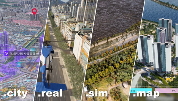
Techtree Innovation has launched AROUND, a high-precision, high-resolution 3D geospatial map platform designed to improve the quality and accuracy of existing 3D maps.
According to the company, AROUND is based on its existing 3D map generation and rendering technology. It offers four solutions for various industrial applications, such as urban or smart city planning, simulation, military and disaster management.
AROUND intends to provide high-precision, high-resolution 3D geospatial maps rendered with satellite maps, GIS data, 3D scanning using the photogrammetry software mapping (PSM) method, and high-end graphic production technology using the Unreal Engine, a 3D rendering platform.
The mapping platform aims to increase realism by implementing various visual geospatial information data — including terrain, buildings, vegetation, roads, transmission towers, traffic lights, signs and signboards, weather conditions, sunlight, coordinate data, elevation differences, and more from the real world. It is characterized by having accuracy and resolution within 5 cm and unifying all high and low altitude resolutions.
AROUND can be used for digital twins, smart city construction, autonomous driving, aviation, military training and education, disaster prediction, smart city or urban planning, review, architecture, design and more.
Image: Techtree
The platform offers four geospatial 3D map solutions tailored to users’ individual needs:
AROUND.city
AROUND.city is a solution that simulates the construction and development of urban areas or buildings. Through city simulation, 3D visualization, and data, AROUND.city can be used for analysis of various environments such as commercial, cultural, and residential facilities, and for space, environment, planning, design, and landscaping. The platform is designed to aid in the establishment and exploration of alternative plans, progress of development and evaluation in urban planning.
AROUND.real
AROUND.real provides high-quality 3D visualization mapping data with all collisions and blocks placed, which can be used in simulators of aircraft such as urban air mobility (UAM), helicopters, airplanes, autonomous cars, and various transportation means based on the development platform.
Using digital twins, AROUND.real allows for safe testing in risky real boarding and training areas. It also implements a variety of accurate and detailed visual-spatial information data, such as real terrain and buildings, grass, roads, utility poles, traffic lights, signs and signboards, weather conditions, and sunlight.
Around.sim
AROUND.sim visualizes refined data on various environmental factors such as building wind, flood, and population density in a specific area using the high-precision, real-world terrain and structures provided by the AROUND platform. Through this, users can predict problems about complex future situations in the same environment as reality, derive insights, or propose solutions.
AROUND.map
AROUND.map is a 3D real-estate marketing solution that already has commercialization achievements in the construction and allotment market. It visually represents the vision and buildings of the future that do not exist at the time of pre-sale, addressing the disadvantages of the existing pre-sale market, and implements all visual expressions such as virtual tours of all surrounding locations and pre-sale complexes, traffic, development plans, development benefits, view rights, and sunlight rights, just like reality.
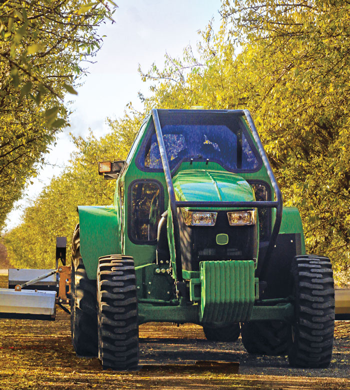
Seirrowon concentrates on the orchards and fixed crop market using u-blox RTK and sensor fusion receivers. (Image: Seirrowon)
I asked Jason O’Flanagan, co-founder and CEO of Seirrowon Labs — which specializes in robotic vehicle control, electronics hardware and firmware development — about the company’s collaboration with u-blox on precision agriculture. Here are a few excerpts from our conversation. Click here for the full version.
I know you’re working with u-blox.
We’re using both hardware and services products from u-blox. We’re using both their normal RTK receiver and their sensor fusion GNSS receiver. We started looking at u-blox, NovAtel, Trimble and Septentrio. However, we settled on u-blox as its mix of services and hardware were best suited to our business model. They provide a fully unlocked, fully functional receiver out of the gate.
In the fixed crop, orchard situation, having as many satellites as possible really helps with your position. So, from a hardware standpoint, it was a perfect solution for us. It allowed us to track up to 85 satellites at a time (two channels each) in adverse conditions. Their sensor fusion version, which is their ZED-F9R, allowed us to fill in the gaps when the GNSS became unusable under the tree foliage. The SL LITE is a generic RTK receiver, the SL LITE-R includes sensor fusion, and the SL Pro uses their L band receiver with the sensor fusion module.
What value do you add to u-blox’s modules?
All they give us is the raw GNSS. We add some IP functionality and support. U-blox outputs its data in a certain format, which is not applicable to the ag industry. So, we map out the data to get it in the right format that will work for a lot of the equipment that’s in the marketplace.
Second, we added a support server to it so that it backs up its settings to a remote server. So, if customers go down, we can flash their replacement receivers and overnight them back to them. The customers are also able to turn on remote support where we can see the data from the receiver and diagnose issues remotely. Our dealers have the same access.
We’ve added a support mechanism into our hardware that allows for better remote support without having to wait hours for someone to get to the field or diagnose an issue. We’ve also added remote updating for support and software. So, the customer can update and add new features remotely without us having to send someone out to do that.
What is involved in installing your equipment on tractors, combines, sprayers and so forth? What kind of support do you provide? I assume you’re brand-agnostic.
We designed our receiver so that anyone can install it. We took a lot of the complications out of it. We use industry standard Deutsch connectors and our device’s user interface is HTML. So, you can use any smartphone or a laptop or any device that has WiFi in it to set up the device. There’s no special software required, there are no special cables; you just connect to it as if it were a hotspot. You can set it up completely from there.
We’ve simplified everything to make sure that users don’t need a degree in GNSS or in engineering to install the receiver. It’s very straightforward. It has several pre-configured profiles within it that allow you to take a generic setup and say, “Hey, I’m putting you here,” so it will default to all the correct settings. We really want to make it as simple and straightforward as possible.
What is the typical use case for your technology?
We have a generalized solution that would be equivalent to, say, a SMART7 from NovAtel. It’s designed for row crop work out in the field and functionality within the standard operations that you get for GNSS receivers within agriculture. Our offering includes the LITE, which is a generic RTK receiver and the LITE-R and PRO, which use active sensor fusion to allow us to function better in orchards and fixed crops that have obstructions to the sky.
I’m concentrating on the orchards and fixed crop market because none of the main OEMs that are out there doing GNSS are taking any time with that market, so that’s where we see our niche.
I asked Jason O’Flanagan, co-founder and CEO of Seirrowon Labs — which specializes in robotic vehicle control, electronics hardware and firmware development — about the company’s collaboration with u-blox on precision agriculture.
What is your background and your company’s origin story?
I’ve been doing precision agriculture for 25 years. I started with Beeline, which was the first company to do automated steering of agricultural equipment, late in the last millennium. I worked for many of the big OEMs, including Kubota and AGCO. I saw an opportunity for GNSS solutions and products. Obviously, there’s a lot of competition there, but we wanted to focus on fixed row crops and orchards because GNSS does not work well in an urban canyon-type scenario. So, there was a niche there for us to jump on.
Were you the company’s co-founder?
Yes, I am one of the company’s co-founders. The company’s name, Seirrowon, is actually “no worries” spelled backward.
I know that you’re working with u-blox.
We’re using both hardware and services products from u-blox. We’re using both their normal RTK receiver and their sensor fusion GNSS receiver. We started looking at u-blox, NovAtel, Trimble and Septentrio. However, we settled on u-blox as its mix of services and hardware were the best suited to our business model. They provide a fully unlocked, fully functional receiver out of the gate.
In the fixed crop, orchard situation, having as many satellites as possible really helps with your position. So, from a hardware standpoint, it was a perfect solution for us. It allowed us to track up to 85 satellites (two channels each) at a time in adverse conditions. Their sensor fusion version, which is their ZED-F9R, allowed us to fill in the gaps when the GNSS became unusable under the tree foliage. The SL LITE is a generic RTK receiver and the SL LITE-R includes sensor fusion and the SL Pro uses their L band receiver with the sensor fusion module.
What value do you add to u-blox’s modules?
All they give us is the raw GNSS. We add some IP functionality and support. U-blox outputs its data in a certain format, which is not really applicable to the ag industry. So, we map out the data to get it in the right format that will work for a lot of the equipment that’s in the marketplace.
Second, we added a support server to it so that it backs up its settings to a remote server. So, if customers go down, we can flash their replacement receiver and overnight them back to them. The customers are also able to turn on remote support where we can see the data from the receiver and diagnose issues remotely. Our dealers have the same access.
We’ve added a support mechanism into our hardware that allows for better remote support without having to wait hours for someone to get to the field or diagnose an issue. We’ve also added remote updating for support and software. So, the customer can update and add new features remotely without us having to send someone out to do that.
Basically, what ag uses violates several of the NMEA conventions. For example, NMEA limits the number of satellite outputs to show 12, but in the ag world all GNSS receivers output the actual number of satellites, using the correction in the NMEA 183 message.
How does the NMEA data format differ from what’s need in agriculture?
Raw GNSS is not sufficient for an active moving solution. Regardless of what GNSS supplier we ultimately chose, the solution provided in GNSS via raw NMEA was not suitable for autonomous or mapping applications by itself. We spent a great deal of time tweaking our output to be best solution possible. This included adjusting for time, terrain and movement. Senor Fusion introduced its own unique issues that we worked through to create the best working solutions. I have spoken to several companies that tried to implement GNSS solutions expecting the raw modules and boards to work out of the box and have been left with a bad taste in their mouth.
In general terms the NMEA 0183 Standards for GGA and VTG don’t have the accuracy required for RTK/PPP performance without violating the length of string limit. We added some additional information to the GGA message to help diagnose issues with performance without needing extra logs and data to see performance. While this does not meet the NMEA 0183 spec it is mostly ignored by Ag equipment downstream. We are currently working with the AgGateway Organization to better use the NMEA spec for use in agricultural applications.
Who stores, aggregates and analyzes the data collected?
We’re not actually taking any position data. We’re just taking GNSS performance information, and the customer must opt in for that. So, it’s defaulted off; if the customer turns it on, it means that we get a complete set of their settings backed up to a server that we own. We have a server with a backup server. So, it comes to our server, and it’s just a just a general setting information that we’re using, and some performance information on satellite tracking, and other things that help us diagnose issues with the receiver. It’s not performance information as far as their location or how they use the receiver. It’s more diagnostic information only.
What is involved in installing your equipment on tractors, combines, sprayers, and so forth? What kind of support do you provide? I assume that you’re brand-agnostic.
We designed our receiver so that anyone can install it. We took a lot of the complications out of it. We use industry standard Deutsch connectors and our device’s user interface is HTML. So, you can use any smartphone or laptop or any device that has WiFi in it to set up the device. There’s no special software required, there are no special cables; you just connect to it as if were a hotspot. You can actually set it up completely from there.
We’ve simplified everything to make sure that users don’t need a degree in GNSS or in engineering to install the receiver. It’s very straightforward. It has several pre-configured profiles within it that allow you to take a generic setup and say, “Hey, I’m putting you here,” so it will default to all the correct settings. We really want to make it as simple and straightforward as possible.
How does it interface with the machine’s steering control?
To interface with the vehicle, we use standard NMEA 0183. We have all the hardware for NMEA 2000 CANBUS but that will come in early 2024.
So, typically, growers just buy the device and have one of their team members put it on?
We normally sell through dealers and OEMs. They incorporate it into their solution. For example one of our dealers uses a system called Weedit. Basically, the distributor incorporates that receiver into each scenario that they have. They must record all that information for EPA in California, so they know exactly what chemicals they put where. So, GPS becomes incredibly important within those orchards to know exactly where the chemical was applied, because they must submit that information.
So, the dealer does the integration onto the machine?
The OEM. However, it is available as a drop-in replacement for any of the old legacy receivers such as Raven receivers that fail over time and some of the other older equipment. So, a general customer that uses Raven equipment can put our receiver in to replace it. I’m just using Raven in this example because it’s a US company that has basically disappeared.
So, it’s not factory-installed and it’s not usually installed by the user, but the dealership put it onto a machine before selling it?
We have dealers and distributors, but it can be installed by an end user as a replacement for a failed old piece of equipment.
Is any of our equipment factory-installed?
No. Not with the big guys anyway. They’re all tied up with their own GNSS at the moment. AGCO is in a pending joint venture with Trimble, CNH Industrial has bought Hemisphere GNSS and Deere has its own offering. So, the big guys all have their own GNSS solutions for now.
The consolidation in the industry is very interesting. I find it curious that in some of the mergers and joint ventures are combinations where both parties already have similar offerings.
Perhaps it’s still evolving.
It sounds like it’s still in the early phases of agreement.
What is the typical use case for your technology?
We have a generalized solution, that would be equivalent to, say, a SMART7 from NovAtel. It’s designed for row crop work out in the field and functionality within the standard operations that you get for GNSS receivers within agriculture. Our offering includes the LITE, which is a generic RTK receiver, and the LITE-R and PRO, which use active sensor fusion to allow us to function better in orchards and fixed crops that have obstructions to the sky.
I’m concentrating on the orchards and fixed crop market because none of the main OEMs that are out there doing GNSS are taking any time with that market, so that’s where we see our niche.
I looked after all the North American support and product direction when I was at AGCO and there was nothing more frustrating than having a product that was complicated to use, difficult to set up, and required multiple people to touch it to make it work. With that in mind, we developed our products to be very simple, very straightforward, able to diagnose most of their problems by themselves, and as functional as possible without having to have someone go out and spend time on diagnosing issues. Our devices are intelligent enough to do that. While generating our product, and putting it into the marketplace, we have spent a lot of time thinking about how to support our customers by avoiding complications and downstream issues.
What else differentiates your company from your competitors?
We have PPP correction services from both satellites from the Internet — similar to services provided by Trimble and NovAtel. However, the industry standard is to only offer a three-month or 12-month subscription, while we offer it monthly. So, you can actually activate it with a phone on the device, purchase a one-month subscription and just use it in the months that you need it. So, a farmer who needs it for only two months in the spring and three months in the fall can pay for only those months instead of having to pay for the whole year. We’re trying to make it as usable and as targeted toward farmers as possible. Through Pointperfect from Ublox. We sell this under our brand name of Flat Earth PPP. (We thought this was a funny name that makes fun of the flat earther movement given that GNSS works because the world is a sphere.)
What else distinguishes your products?
Our receivers are completely unlocked and ready to go out of the gate, without nickel and diming customers or holding features back from them. When they pay for the system, they get everything. If you are going to unlock a feature on a NovAtel or Trimble receiver, you have to get back to the dealership, they then have to use some e-commerce system to purchase that Auth code, then they either give the customer this huge, 64-character code, or someone has to come out and make that change. We don’t have to do any of that. Everything’s unlocked and ready to go.
Our use case is focused on a low profile, a small footprint, and a ruggedized enclosure. We came up with a unique design of antenna that resulted in reduced size without losing any performance. As a result, our receiver is only 35mm tall, 100mm wide and 180mm long. We have filed a patent on this unique design. We also designed it for most agricultural environments by having protection on all IO and the ability to be powered from 9-36V to meet the requirements of both US and European agricultural applications.
Because of the low-profile requirement, we needed a receiver module that is mounted to the board directly instead of a separate receiver board that would have made the enclosure taller.
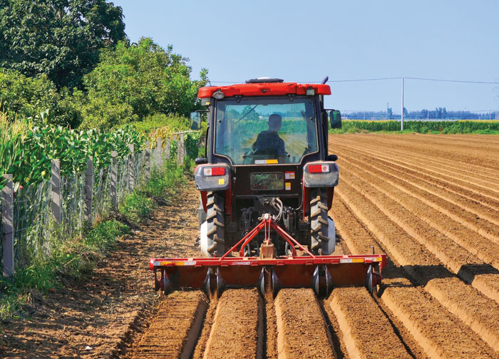
CHCNav’s NX510 SE GNSS RTK auto-steering system helps growers achieve the precision required for specialized planting operations. (Image: CHCNAV)
CHC Navigation’s NX510 SE GNSS RTK auto-steering system helps growers around the world achieve the precision required for specialized planting operations.
Intercropping. Growing two or more crops together in the same field, known as intercropping, is a sustainable and effective agricultural practice that is being adopted worldwide to increase yields. It is a bit counter-intuitive because it forces the different crops to compete for water, light, and nutrients. However, if the plants are carefully selected, their seeds are correctly spaced, and their growth is properly managed, it can be a recipe for success. For example, legumes, such as soybeans, which are good at nitrogen-fixing, can provide nitrogen to corn, thereby reducing the need for additional nitrogen fertilizer and the concomitant risk of chemical runoff. Mixing these two plant species also increases biodiversity and ecological stability. However, if the seeding is not planned carefully and executed precisely, the corn’s tall stalks will shade the soybeans’ short stems and reduce their yields.
Mr. Chen, a farmer and president of Agricultural Machinery in Anhui, China, co-crops corn and soybeans in the same field. To seed them precisely, he relies on CHCNAV’s NX510, which has a pass-to-pass accuracy of ±2.5 cm. Prior to using an automated steering system, his yields suffered because his seed rows were not straight. The system makes planting a simple task: the operator sets the row spacing for crops and the tractor automatically maintains it. Operators can also share those patterns among multiple farm machines, greatly increasing efficiency.
Growing rice. About half of the world’s population — especially in Asia, South America, and sub-Saharan Africa — relies on rice as its staple food. China is consistently ranked among the top 10 rice-producing countries due to its ability to cultivate it during two to three rice-growing seasons per year. Rice farmers around the world share challenges, including resource depletion due to soil degradation, urbanization, the effects of climate change, and a shrinking labor force, especially skilled labor.
Every rice planting season is a race against time and requires optimizing efficiency, including executing precise, straight-line planting operations to accurately align the new rice crop with previously established rows of seedlings. Any inaccuracy can sharply reduce rice yields. This is a key concern in China, which has only 0.02 hectares of rice land per capita. It is also vital to achieve sustainability and minimize environmental impact.
In a recent application, the NX510 has been successfully integrated into rice transplanters used to plant rice seedlings in swampy soils in China. It ensured that rice seedlings were planted at consistent depths and in the correct vertical and horizontal positions, promoting adequate ventilation and optimal light exposure for their subsequent growth.
NX510 SE. The NX510 SE utilizes five satellite constellations — GPS, GLONASS, Galileo, BeiDou and QZSS — and multiple correction sources, including 4G RTK networks and UHF RTK stations. Its built-in 4G and UHF modem connects to all industry-standard DGPS and RTK corrections and its terrain compensation technology maintains high accuracy even in challenging environments and terrain. The receiver’s 10.1-inch industrial display, operating on the AgNav multilingual software, supports multiple guidelines patterns, including AB line, A+ line, circle line, irregular curve and headland turn, to handle all common farming operations.
The NX510 autosteering system delivers significant productivity gains at a cost accessible to nearly every farm, making it suitable for retrofitting old and new farm vehicles. An additional advantage of autosteering is that it enables growers to maintain the same high level of accuracy when operating at night, which is often required to escape the oppressive daytime heat or to meet tight schedules.
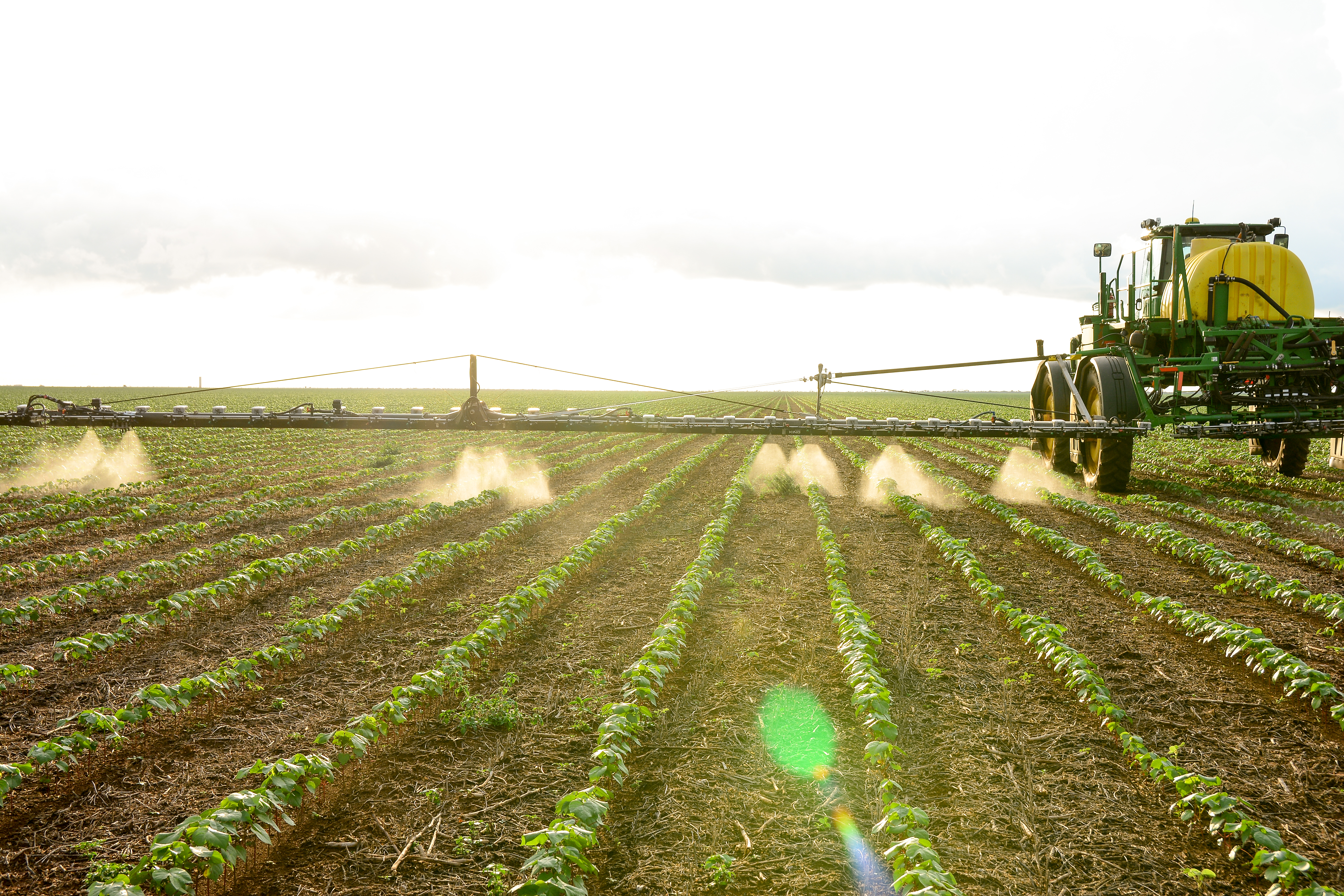
Trimble’s WeedSeeker 2 automatic spot spray system uses advanced optics and processing power to detect and eliminate resistant weeds. (Image: Trimble)
In September 2023, Trimble announced an agreement to form a joint venture (JV) with AGCO “to better serve farmers with factory fit and aftermarket applications in the mixed fleet precision agriculture market.” I discussed the announcement with David Britton, vice president of product management, Trimble Agriculture.
Your press release says “Trimble and AGCO’s shared vision is to create a global leader in mixed fleet, smart farming, and autonomy solutions.” What does mixed fleet mean in this context?
That’s focused on the farmers’ ability to use any brand of tractor or implement together. As you can imagine, there are multiple OEMs in the market. One of the beliefs that Trimble’s had, and that AGCO shares, and why this JV makes sense, is that the farmers’ decisions around what technology they use and the way that their farms operate shouldn’t be inextricably tied to the brand of tractor that they use.
So, they could use an AGCO tractor, but with a GNSS receiver that’s not from Trimble or vice versa?
More so that on their farm they could have equipment from AGCO and other OEMs. In many cases, they’ll have more than one tractor and multiple different implements.
Those machines can talk to each other and share the data.
Ideally, yes.
Image: Trimble
What will be the division of labor between Trimble and AGCO? How will the interface work?
The JV will not be involved with any of the tractor manufacturing, which will stay within AGCO. We’re going to be focused on the precision ag technology that will go into the tractor, help manage the implements, and complete the work, as well as the data systems that underpin that.
Currently, Trimble Ag has capabilities on embedded display software that are used to help manage activities in the field and steer the vehicle. We also have cloud software that allows farmers to manage their information and data and work with other people in their ecosystem, as well as many other things. That’s all going into the JV. Trimble will supply GNSS technology to the JV, which is a foundation to enable geolocating the information in the activities.
Then you have JCA Industries [which AGCO acquired in 2022] that has been focused on implement control and autonomy. So, the two businesses are complementary. They are coming together to focus on higher technology components and then work with both AGCO as well as other manufacturers and the aftermarket to deliver smart farming and autonomy solutions into the farm to help farmers run their businesses and farms more efficiently.
Tell me more about the aftermarket.
One of the key things that we’ve seen historically, and we expect the trend to continue, is that you’ll see innovation happen in the aftermarket first, because it gives a chance to rapidly iterate and learn before you go through the process of putting it into the factory. We expect that we’ll have a very healthy aftermarket business, as well as a portion of the business where our technology will be factory-fit into machines from both AGCO and other manufacturers, because that’s been an important part of the Trimble business. Being able to work with other OEMs to provide important technologies will be a part of that story.
Are you still expecting the deal to close in the first half of 2024?
That’s still the target.
Will the JV sell anything or will it be totally transparent to the user?
The JV will have its own channel to the aftermarket, as well as people working with OEMs from a sales perspective. In terms of branding, that’s something that’s being evaluated right now. Ultimately, the JV will have a channel to the aftermarket and we also have our own relationships with OEMs through which we will continue to sell. So, the end customers should be aware that they’re purchasing technology that has been built by the JV.
Under a name or branding that is still to be determined?
Yes.
Over time, the JV will become the main way for Trimble to sell its precision ag equipment.
Correct. Trimble will go into the ag market primarily through the JV.
Will Trimble also continue to sell to other OEMs other than AGCO?
Trimble will sell ag equipment to other ag OEMs via the JV.
Image: Trimble
Does that mean that AGCO, through the JV, will sell equipment to some of its competitors?
My understanding is they already have businesses that do that currently. Their Precision Planting business works with other OEMs as well as other businesses that they’ve brought into the AGCO family. So, it’s not new for AGCO to have a part of the business that is selling to OEMs in some ways. Trimble has some experience with that as well.
We recognize that it’ll be important for our customers to trust that their data is being managed appropriately. That said, it’s a great way for other OEMs to have access to scale. As we talk about what needs to happen for precision ag to realize the opportunity that comes with technology, scale is going to become increasingly important, which I think is a part of why this JV is so exciting for both Trimble and AGCO. Ultimately, it should be exciting for farmers as well because it’s going to create a very well scaled business that can help provide technology very effectively.
Who will collect, aggregate, analyze, and control the data? How will farmers access it?
We’ll continue to work with the end customers and to find ways that we can ensure that they have the right access to and ownership of their data, while also looking for ways that we can use anonymized data to enhance product functionality.
Is that an opt in or an opt out?
The JV’s policy on that has not been determined yet.
For which crops or scenarios do you expect the greatest adoption of the JV’s technology?
There are places where you see the adoption of precision ag technology more than others, in terms of larger scale farms and high value crops. Ultimately, we take pride in being a global business, which means that we’re thinking about all areas of the globe, as well as multiple crop types. So, every region has crops that are particularly important to it. We try very much to build solutions that fit those local markets, while also leveraging what we can from a scale perspective. There isn’t one particular crop type or one particular region that dominates our thinking at this point.
Trimble has its RTX correction service. Does AGCO have its own?
Trimble will keep RTX but also make it available to the JV and to AGCO, which does not have its own solution. So, RTX is a very good fit. That’s one of the benefits you see in the JV. We’ve already been working with them from an RTX perspective on receivers that we’ve provided. So, we’re more excited to continue that through the JV.
Will the JV come up with any new tiers for corrections?
The JV will work with Trimble to come up with what’s right for the market. As you’ve seen RTX evolve over the years, we’ll continue that process working with Trimble to figure out the right tiers and the right solution for what the farmers need.
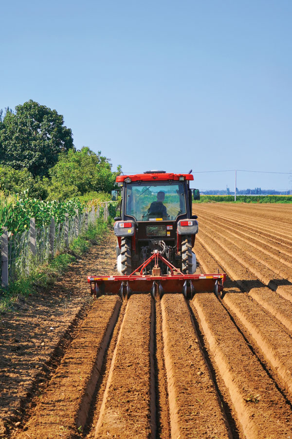
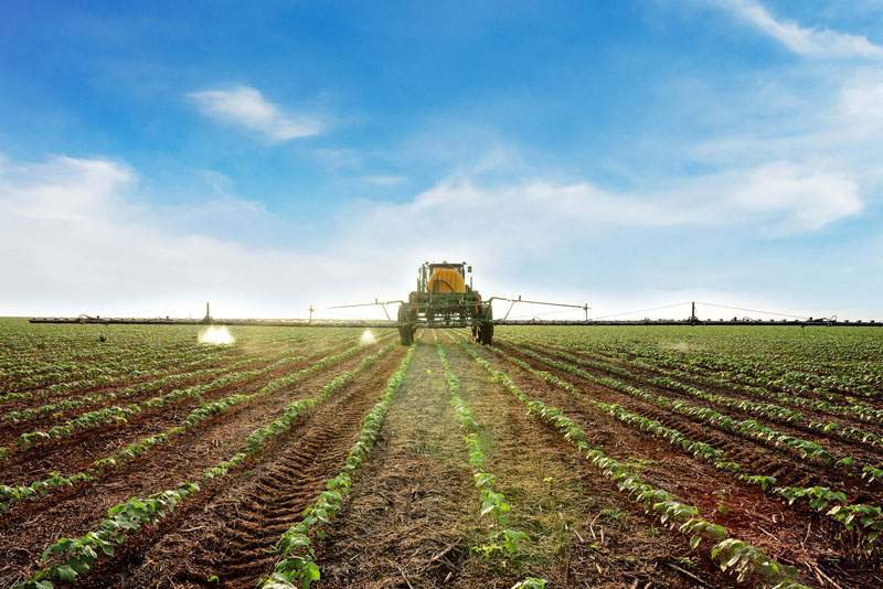
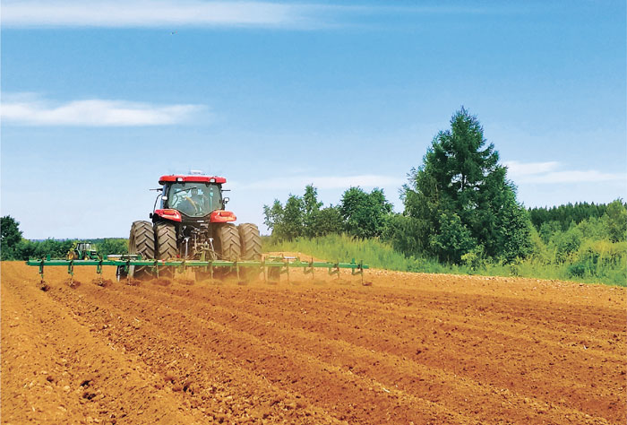
Precision agriculture — which enables growers to reduce inputs of water, fertilizers and pesticides by matching them to variations in soil conditions, thereby reducing environmental impacts, increasing yields and productivity, and reducing fuel consumption — is a prime use case for global navigation satellite systems (GNSS). While the typical open sky conditions in the fields minimize concerns about signal occultation and multipath, the accuracy requirements for this practice, particularly for certain crops and planting techniques, can be very high. Challenges for receivers often include severe roll and pitch due to bumpy terrain, the requirement to maintain exact heading at very low speeds, and the need to receive corrections over very large areas.
Precision agriculture began more than 30 years ago — GPS World published a few issues of a special supplement on the subject about 25 years ago — and now all tractors from major manufacturers come equipped with a GNSS-based guidance system. Adoption has increased hand-in-hand with improvements in enabling technologies. These include satellite-based and ground-based sensors, UAVs, geographic information systems (GIS), and a plethora of GNSS corrections services (see “Corrections Services Abound” in our January 2023 issue and “Understanding GNSS Correction Methods” on p. 28 of our January 2024 issue).
In this cover story, we present three recent developments in precision agriculture. Click below to read more about: