Category: Space & Earth

  • Amateurs with smartphones help monitor GNSS signals in space

    Amateurs with smartphones help monitor GNSS signals in space

    This graphic represents measurements uploaded via the CAMALIOT app by thousands of volunteers. (Image: ESA)
    This graphic represents measurements uploaded via the CAMALIOT app by thousands of volunteers. (Image: ESA)

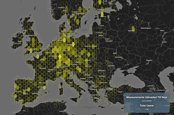
    More than 11,000 people around Europe and the world have turned their smartphones into GNSS monitoring tools by downloading the CAMALIOT app, so far delivering more than 53 billion measurements of meteorology and space weather patterns to researchers, according to the European Space Agency (ESA).

    ESA asks CAMALIOT volunteers to leave their smartphones by a window each night with GNSS on. The phones record small variations in satellite signals, gathering data for machine-learning analysis. More than 50 smartphone models with dual-frequency receivers can use the app.

    CAMALIOT was developed through ESA’s Navigation Innovation and Support Programme (NAVISP) with the support of the agency’s Navigation Science Office through its GNSS Science Support Centre. The combination of GNSS data, smartphone access and machine learning in support of science is a priority research line of ESA’s Navigation Science Office.

    GNSS signals undergo scintillation as they pass through irregular plasma patches in the ionosphere. This electrically charged upper atmospheric layer is continuously changing, influenced by solar activity, geomagnetic conditions and the local time of day. Dual-frequency GNSS receivers can compensate for this effect by comparing their two frequencies.

    As these signals head to Earth, they are also modified by the amount of water vapor in the lower atmosphere, helping to forecast rainfall in particular.

    “Fixed satnav stations already monitor these effects, but these smartphone-based measurements are boosting our coverage hugely. We’re very gratified by all the support we’ve received,” said Vicente Navarro, ESA navigation engineer. ”These results will then undergo a Big Data machine-learning analysis, seeking out previously unseen patterns in both Earth and space weather.”

    Formally known as the Application of Machine Learning Technology for GNSS IoT Data Fusion project, CAMALIOT is run by a consortium led by ETH Zurich in collaboration with the International Institute for Applied Systems Analysis.

  • CACI to demonstrate time-based navigation to support GPS

    CACI to demonstrate time-based navigation to support GPS

    Artist's impression of the CACI/York Space DemoSat scheduled to launch in January 2023. (Credit: CACI)
    Artist’s impression of the CACI/York Space DemoSat scheduled to launch in January 2023. (Credit: CACI)

    CACI International, a U.S. defense contractor, plans to demonstrate a supporting navigation technology for military use as part of its DemoSat launch in January 2023.

    CACI will launch two demonstration payloads on a York Space Systems satellite scheduled to fly to low Earth orbit in January aboard the SpaceX Transporter 7 rideshare.

    The payload will contain an alternative positioning, navigation and timing solution that will work in a contested space domain. It is designed to support rather than replace GPS.

    The technology is two-way time transfer and clock modeling technology. Two-way time transfer has been used for years on the ground, but in this case will be used in space. The low size, weight and power (SWaP) space-based PNT is expected to significantly improve multi-platform remote sensing.

    If the experiment is successful, CACI plans to offer the two-way time transfer PNT service to the military and other government agencies.

    CACI has completed the critical design review for the DemoSat. CACI and its partner York Space Systems will also demonstrate a tactical intelligence, surveillance and reconnaissance (TacISR) payload. The TacISR payload identifies and captures key signals of interest and operates with CACI’s Beast ground receiver to demonstrate real-time radiofrequency geolocation for deployed U.S. forces.

    “CACI expertise, systems, and technology help our customers maintain dominance in the increasingly contested space environment,” said Mike Hale, executive vice president of CACI’s Advanced Solutions Group. “We are very proud that CACI is launching a DemoSat payload into orbit – distinguishing our mission technology and transformative solutions for customer success.”

  • EUSPA recounts accomplishments at first anniversary

    EUSPA recounts accomplishments at first anniversary

    The European Union Agency for the Space Programme (EUSPA) is celebrating its one-year anniversary by sharing its achievements, including through a new video and an interactive quiz.

    EUSPA’s mission is to link space to user needs. Over the past year, EUSPA has increased access to EU space data and services around the world, launched new Galileo satellites, and put in place additional satellite navigation services.


    Think you know the EU Space Programme? Prove it by taking EUSPA’s interactive quiz.


    EUSPA operates Europe’s satellite navigation systems Galileo and EGNOS. It is also the gatekeeper to a secure EU Space Programme, providing end users with the confidence of knowing that the space-derived data they depend on is safe and secure.

    The agency plays a central role in the market uptake of the data and services offered by the EU Space Programme components. EUSPA also manages the development of GOVSATCOM hubs, which will provide secure, cost-efficient communication capabilities to security and safety-critical governmental missions, operations and infrastructure.


    On 17 May, EUSPA is hosting a GNSS Raw Measurements Task Force meeting, a chance to learn the latest on using GNSS raw measurements with Android devices.


    First-year accomplishments include:

    “I am more than proud of what EUSPA has achieved in a year. I am also proud to be at the helm of an organization staffed with dedicated professionals, with a service-oriented mindset who work to make EU Space accessible to citizens,’’ said Rodrigo da Costa, EUSPA executive director. “EUSPA remains committed to helping the union and its citizens maximize the socio-economic benefits of space.”

    Image: EUSPA
    Image: EUSPA
  • Emcore contracted for navigation for space launch vehicles

    Emcore contracted for navigation for space launch vehicles

    Initial value of the contracts is expected to be more than $12 million

    Logo: EmcoreEmcore Corporation has been awarded new contracts for the Booster Rate Gyro (BoRG) and Tri-Axial Inertial Measurement Unit (TAIMU) programs for space launch vehicles resulting from its acquisition of the L3Harris Space and Navigation business.

    The BoRG program award is a contract valued at more than $12 million for the production of IMUs used for flight stabilization of the booster stage of a multistage launch system. The TAIMU program award is a development contract for the design and qualification of IMUs deployed for navigation and flight control of the upper stage of a multistage launch system.

    Pending successful demonstration of required capability and quality, Emcore expects to be awarded follow-on production contracts for TAIMU within the next 12 months.

    “We are honored to supply our highest grade inertial navigation equipment for these critical space launch vehicle programs,” said Albert Lu, senior vice president and general manager, Aerospace and Defense for Emcore. ”We look to further our close partnership with L3Harris through successful on-time deliveries for both the BoRG and TAIMU programs,” Lu added.

    Acquisition Closes

    Emcore’s acquisition of the L3Harris Space and Navigation business closed on May 2. Emcore acquired the business for approximately $5 million in an all-cash transaction, subject to any net working capital adjustments.

    The acquisition expands Emcore’s inertial navigation product portfolio with the addition of navigation-and strategic-grade gyro and inertial measurement unit products.

    Emcore acquired all outstanding assets and liabilities of the L3Harris Space and Navigation business, including all L3Harris intellectual property rights primarily used in the Space and Navigation business, a 110,000-square-foot leased production facility in Budd Lake, New Jersey, and associated production equipment.

  • GNOMES-3 GNSS radio-occultation satellite launched

    GNOMES-3 GNSS radio-occultation satellite launched

    Artist's illustration of a GNOMES satellite. (Image: Blue Canyon)
    Artist’s illustration of a GNOMES satellite. (Image: Blue Canyon)

    A new GNSS radio-occultation (RO) satellite is now in orbit. The GNOMES-3 — GNSS Navigation and Occultation Measurement Satellite — flew aboard the SpaceX Falcon 9 Transporter-4 rideshare mission on April 1 and was launched into a 646-km circular sun-synchronous orbit. The payload was powered on and operating nominally within four days of launch.

    The GNOMES-3 was manufactured for PlanetiQ by Blue Canyon Technologies LLC, a wholly owned subsidiary of Raytheon Technologies. Using refracted GNSS signals, PlanetiQ can determine the density and moisture content of the atmosphere to improve weather predictions, helping improve NOAA weather models.

    The GNOMES-3 joins GNOME-2 on orbit and is expected to achieve highly accurate GNSS-RO measurements using the fourth-generation Pyxis-RO sensor. PlanetiQ plans to launch more Pyxis-RO atmospheric and ionospheric sounding spacecraft in 2023. In all, PlanetiQ plans for a fleet of 20 GNOMES by 2024.

    The GNOMES-2, launched in June 2021 on SpaceX’s Transporter-2 mission, produces more than 3,200 soundings of the Earth’s atmosphere and 5,000 ionosphere soundings per day with a large-aperture RO antenna that tracks all four GNSS constellations: GPS, Galileo, GLONASS and BeiDou.

    The soundings have sufficient signal-to-noise ratio to indicate the location of the planetary boundary layer, as well as detect super refraction at the boundary layer and near the Earth’s surface. The higher quality GNSS-RO soundings, along with the associated lower troposphere assimilation tools, will be used to produce more accurate weather forecasting and hurricane tracking, and aid in energy, transportation and agriculture industries as well as serve as a climate record with its SI-traceable data.

  • Seen & Heard: Shackleton’s ship, Beijing underground

    Seen & Heard: Shackleton’s ship, Beijing underground

    “Seen & Heard” is a monthly feature of GPS World magazine, traveling the world to capture interesting and unusual news stories involving the GNSS/PNT industry.


    Photo: dk1234/iStock/Getty Images Plus/Getty Images
    Photo: dk1234/iStock/Getty Images Plus/Getty Images

    POSITIONING UNDERGROUND

    A “BeiDou positioning system for subways” began construction March 20 on the Beijing subway capital airport express line. The project will cover a 30-kilometer-long section of the express line, including five stations. To provide positioning, the BeiDou Navigation Satellite System (BDS) will be combined with 5G for indoor positioning or in areas where the satellite signals are blocked. The system will improve the positioning accuracy in subways to less than 2 meters, making it available for vehicle dispatching, passenger transport organization and emergency response. In addition, it allows passengers to use their phones to navigate and position in complex environments in subway stations through three-dimensional navigation.


    Image: ESA
    Image: ESA

    THE SHAPE OF OCEAN WATER

    The European Space Agency (ESA) investigated a technique to precisely measure sea-surface topography based on an idea submitted by the Institute for Space Studies of Catalonia (IEEC). The technique involves GNSS reflectometry — signals that have been reflected off of the sea surface at very low angles. The ESA-funded activity involved developing a GNSS receiver and setting up an experiment in the Balearic Islands to collect GNSS signals reflected off the sea surface. The team linked the coherence of the reflected signals to wave height and elevation angle of GNSS satellites. The team then processed the signals for optimized measurements of the shape of the sea surface, useful in applications such as ocean current forecasting, climate research, ship routing, cable laying and debris tracking.


    Image: Japan network/Ohta and Ohzono, Tohoku University
    Image: Japan network/Ohta and Ohzono, Tohoku University

    CELLPHONE NETWORK DETECTS EARTHQUAKES

    A paper published Feb. 9 in Earth, Planets and Space by Japanese Earth science researchers analyzed the potential of a dense network of GNSS receivers, installed at cellphone base stations, to monitor crustal deformation as an early warning indicator of seismic activity. Results showed that data from a cellphone network can rival the precision of data from a government-run GNSS receiver network, while providing more complete geographic coverage. Japanese cellphone carriers have constructed networks of GNSS receivers to improve locational information for such purposes as automated driving. The study examined the potential of a GNSS network built by SoftBank Corp. to play a role in monitoring crustal deformation.


    Photo: Falklands Maritime Heritage Trust
    Photo: Falklands Maritime Heritage Trust

    ENDURANCE IN POLAR ICE

    Researchers have discovered the remarkably well-preserved wreck of polar explorer Ernest Shackleton’s ship, Endurance, a century after it was swallowed up by Antarctic ice. A team of marine archaeologists, engineers and other scientists used an icebreaker ship and underwater drones to locate the wreck at the bottom of the Weddell Sea, near the Antarctica Peninsula. The ship is at a depth of 3,008 meters, 4 miles south of the position originally recorded by navigator Frank Worsley. The expedition team used two Saab autonomous underwater vehicles to explore in a pre-programmed search pattern. After the ship was located, technicians swapped out sonar equipment for a high-resolution camera and a laser-surveying device to make highly detailed scans of the site.

  • Analog Devices converter sets performance benchmarks for harsh environments

    Analog Devices converter sets performance benchmarks for harsh environments

    Radio frequency analog-to-digital converter sets performance benchmarks for space and harsh environments

    Photo: Analog Devices
    Photo: Analog Devices

    Analog Devices has released the AD9213S-CSH, a highly integrated RF analog-to-digital converter (ADC). The ADC is a 12-bit, 10.25 giga samples per second (GSPS) ADC in high-reliability packaging, with advanced production screening and quality inspection.

    It is the company’s fastest ADC available for the space environment.

    The AD9213-CSH enables the next generation of software-defined systems for satellite communications, radar and remote sensing, driving greater system integration, lower costs, reduced power consumption and decreased size, weight and power (SWaP).

    Additionally, a high sample rate and integrated post-processing enable further performance gains for narrow-band applications.

    The AD9213-CSH provides space customers with greater flexibility and the ability to process larger sections of the spectrum for electronic support measures, as well as increased-resolution radar designs.

    The wider Nyquist bandwidth allows satellite-communications customers to deliver products with increased bandwidth. In addition, wide input bandwidths combined with high sample rates enable new wideband digital predistortion architectures communications applications.

  • Orbital Insight partners with Satellogic on satellite imagery and video

    Orbital Insight partners with Satellogic on satellite imagery and video

    A sample image from Orbital Insights showing classes of military aircraft at a base. (Image: Orbital Insights)
    A sample image from Orbital Insights showing classes of military aircraft at a base. (Image: Orbital Insights)

    Orbital Insight will integrate Satellogic’s high-resolution multispectral imagery, hyperspectral imagery, and full-motion video into its GEOINT platform

    Geospatial intelligence company Orbital Insight has partnered with Satellogic, a leader in sub-meter resolution satellite imagery collection. The partnership will integrate Satellogic’s high-frequency, high-resolution collections of satellite imagery and full-motion video into Orbital Insight’s platform and offer customers better access to high-quality data, improve the revisit rate, and reduce the cost of running analytics.

    Satellogic designs, manufactures and operates its own constellation of Earth observation satellites. It  has 22 operational satellites in low Earth orbit with plans to launch up to 12 additional satellites by the end of the year. The company aims to expand its constellation to more than 200 satellites by 2025 for daily global coverage of the entire surface of the Earth.

    Orbital Insight’s flagship GO platform combines information from the world’s sensors to analyze economic, societal and environmental trends at scale and support activity-based intelligence. Commercial businesses and government agencies use the self-service platform to synthesize answers to critical questions about what’s happening on and to Earth.

    Satellogic will provide high-resolution Earth observation data at vastly superior unit economics. This will allow Orbital Insight customers to increase the number of daily revisits on points of interest, see a more granular picture and get deep insights that were not possible before.

    “Advanced geospatial analytics require access to high-resolution, high-frequency satellite imagery and simple tasking,” said Kevin O’Brien, CEO, Orbital Insight. “Satellogic is disrupting the industry with a cost-effective, vertically integrated business model. This approach aligns well with our philosophy of making geospatial intelligence efficient, intuitive, and simple so that our customers can get timely insights, make critical decisions, and respond faster.”

    “Our mission is to enable greater access to critical Earth observation data. Working with Orbital Insight extends our reach, making our data available to more customers across diverse fields who need to know how the world around them is changing,” said Emiliano Kargieman, CEO and co-founder of Satellogic.

  • The Moon: Where no satnav has gone before

    The Moon: Where no satnav has gone before

    News from the European Space Agency

    The test version of a unique satellite navigation receiver has been delivered for integration testing on the Lunar Pathfinder spacecraft.

    The NaviMoon satnav receiver is designed to perform the farthest ever positioning fix from Earth, employing signals that will be millions of times fainter than those used by smartphones or cars on Earth.

    The NaviMoon receiver and low-noise amplifier. (Photo: SSTL)
    The NaviMoon receiver and low-noise amplifier. (Photo: SSTL)

    “This engineering model of our NaviMoon receiver is the very first piece of hardware to be produced in the context of ESA’s Moonlight initiative, to develop dedicated telecommunications and navigation services for the Moon,” explained Javier Ventura-Traveset, head of ESA’s Navigation Science Office and manager of ESA lunar navigation activities.

    “It will be flown aboard the Lunar Pathfinder mission into orbit around the Moon, from where it will perform the furthest satellite navigation positioning fix ever made, at more than 400,000 kilometers away to an accuracy of less than 100 meters,” Ventura-Traveset said. “This represents an extraordinary engineering challenge, because at such a distance the faint Galileo and GPS signals it uses will be barely distinguishable from background noise. This demonstration will imply a true change of paradigm for lunar orbiting navigation.”

    Relaying signals for multiple lunar missions
    Relaying signals for multiple lunar missions

    The washing-machine-sized Lunar Pathfinder is being built as a commercial mission by Surrey Satellite Technology Ltd. (SSTL), in the United Kingdom. ESA is funding guest payloads for it, including the 1.4-kg NaviMoon receiver that will be accommodated beside the spacecraft’s main X-band transmitter that links it with Earth.

    “Receiving physical hardware for a mission is always fantastic,” said Lily Forward, SSTL system engineer. “This engineering model receiver will be integrated into our FlatSat Test Bed version of the mission to test that all our systems communicate and work together properly, ahead of receiving the flight-model receiver and antenna later this year.”

    Lunar Pathfinder will relay communications from orbital and surface missions
    Lunar Pathfinder will relay communications from orbital and surface missions

    This will be SSTL’s first full-fledged mission beyond Earth, she added. “Laying the foundations for numerous scientific missions that will come after it, Lunar Pathfinder is a communications relay satellite, intended to serve assets on both the nearside and farside, orbiting in an elliptical lunar frozen orbit for prolonged coverage over the South Pole — a particular focus for future exploration. Then, during regular intervals, we will orient the spacecraft towards Earth to test out the NaviMoon receiver.”

    Satnav position fixes from the receiver will be compared with conventional radio ranging carried out using Lunar Pathfinder’s X-band transmitter as well as laser ranging performed using a retroreflector contributed by NASA and developed by the KBR company.

    Laser ranging station
    Laser ranging station

    “This will be the first time these three ranging techniques will be used together in deep space,” explained ESA navigation engineer Pietro Giordano. “There is a long heritage of lunar laser ranging, going back to the Apollo missions, and the retroreflector we are using is an evolution from NASA’s Lunar Reconnaissance Orbiter. The combination of all ranging techniques will improve the orbit estimation further, potentially beyond what radio ranging can achieve.

    “In principle, this could mean that future missions could navigate themselves to the Moon autonomously using satellite navigation signals alone with no help from the ground.”


    Galileo 'side lobe' signals
    Galileo ‘side lobe’ signals

    Finding ultra-faint satnav signals

    The satnav signals employed here on Earth are already vanishingly faint, equivalent to a single pair of car headlights shining all across Europe. By the time these signals reach the Moon, they have crossed distances of more than 20 times further, attenuating through space like ripples from a stone splashed in water.

    “Adding to the difficulty, the satnav constellations are not designed to transmit up into space, but to keep their antennas facing Earth,” Giordano said. “So we are reliant on much weaker side-lobe signals, like light spilling from the sides of a flashlight. To be able to make use of these signals, we turned to a specialist in space-based satellite navigation, whose signal-processing techniques have really proven the magic ingredient.”

    Testing the NaviMoon receiver and Low Noise Amplifier engineering models at SSTL ahead of integration testing. The flight models of the receiver and amplifier will be delivered later in 2022. (Photo: SSTL)
    Testing the NaviMoon receiver and Low Noise Amplifier engineering models at SSTL ahead of integration testing. The flight models of the receiver and amplifier will be delivered later in 2022. (Photo: SSTL)

    SpacePNT, based in Switzerland, oversaw the NaviMoon receiver design.  “We began working on the idea of lunar-distance satnav positioning back in 2013 as something of a scientific challenge,” said Cyril Botteron, company head.

    “The combination of Galileo dual-frequency signals with those of the existing GPS satellites is what started to make it feasible,” Botteron said. “Although, along with the extreme sensitivity that is demanded, the other big problem is that from the Moon all the satnav satellites are in the same narrow geometry of sky around Earth, periodically rotating out of view.”

    Lunar navigation satellites will ultimately help guide Moon landings, such as with the European Large Logistic Lander. (Image: ESA)
    Lunar navigation satellites will ultimately help guide Moon landings, such as with the European Large Logistic Lander. (Image: ESA)

    The solution that SpacePNT came up with leverages more than half a century of lunar exploration. The company installed a dynamic software model of all the forces acting upon the satellite into the receiver, including the gravitational influences of the Moon, Earth, Sun and planets as well as the very slight push from sunlight itself — solar radiation pressure — along with factors such as clock error and the radio signal direction.

    “As we experience a given acceleration the receiver can judge it is most probably at one particular point in its orbit,” Botteron said. “Usually a satnav receiver needs signals from four satellites to fix its position, but with this approach, less than four signals is still enough to obtain useful information, constraining the model to minimize any error drift.”

    European Engineering & Consultancy (EECL) in the UK was assigned the task of turning SpacePNT’s design into fully tested hardware, and also designed the crucial low-noise amplifier that sifts through noise to boost usable signals.

  • US bans anti-satellite weapon tests, seeks global agreement

    US bans anti-satellite weapon tests, seeks global agreement

    Vice President Kamala Harris speaks to media representatives alongside leadership from the U.S. Space Force and U.S. Space Command during her visit to the Combined Space Operations Center (CSpOC). (Photo: USSF)
    Vice President Kamala Harris speaks to media representatives alongside leadership from the U.S. Space Force and U.S. Space Command during her visit to the Combined Space Operations Center (CSpOC). (Photo: USSF)

    Updated April 20 with additional information.


    The United States government has committed to ending the practice of anti-satellite missile tests, Vice President Kamala Harris announced April 18 at Vandenberg Space Force Base. She also urged other nations to follow its lead.

    On Nov. 15, 2021, the Russian military destroyed a defunct satellite with its anti-satellite technology (ASAT), a test it followed with verbal threats to the U.S. GPS.

    The Russian test created thousands of pieces of debris in low Earth orbit, and sent astronauts on the International Space Station into shelter as it passed through the debris field.

    Image: janiecbros/iStock/Getty Images Plus/Getty Images
    Image: janiecbros/iStock/Getty Images Plus/Getty Images

    Harris made the announcement during an all-call in front of more than 200 members of the Space Force and Air Force.

    Harris, who chairs the National Space Council, called on other nations to make similar commitments and to work together in establishing this as a norm, saying such efforts benefit all nations. “It is clear there is strong interest among our international partners to develop these norms. We must write the new rules of the road, and we will lead by example,” she said.

    “The destruction of space objects through direct-ascent ASAT missile testing is reckless and irresponsible,” Harris said. “The long-lived debris created by these tests now threaten satellites and other space objects that are vital to all nations’ security, economic, and scientific interests, and increases risk to astronauts in space. Overall, these tests jeopardize the long-term sustainability of outer space and imperil the exploration and use of space by all nations.”

    In addition to making this announcement, Harris toured the Combined Space Operations Center (CSpOC) and met with U.S. Space Force Maj. Gen. DeAnna Burt, Combined Force Space Component Command commander, as well U.S. and coalition personnel who work in space operations, to learn about U.S. efforts in space and the dangers posed by anti-satellite missiles.

    The CSpOC is comprised of both U.S. and allied partners and operates 24 hours a day, seven days a week. It executes the operational command and control of space forces to achieve theater and global objectives. Additionally, the CSpOC hosts a Commercial Integration Cell representative to enhance cooperation with several commercial partners.

    This was the first vice presidential visit to the nation’s premier West Coast launch installation since it was redesignated in May 2021 from an Air Force base to a Space Force base. The department of the Air Force announced April 4 that the base is the possible future home of the U.S. Space Force’s training headquarters.

    While Harris toured the CSpOC, her husband, Second Gentleman Douglas Emhoff, met with military and civilian spouses to discuss employment, mental health programs and diversity and inclusion.

    Also in attendance at the all-call were Deputy Secretary of Defense Kathleen Hicks; Gen. James Dickinson, U.S. Space Command commander; Gen. John “Jay” Raymond, chief of space operations for U.S. Space Force; Sen. Alex Padilla, Rep. Salud Carbajal and Rep. Ted Lieu.

  • Hexagon AB freezes business operations in Russia

    Hexagon AB freezes business operations in Russia

    Logo: Hexagon ABBecause of circumstances following Russia’s invasion of Ukraine, Hexagon AB has made the decision to freeze all business activities in Russia. Hexagon AB is a global leader in digital reality solutions combining sensor, software and autonomous technologies.

    Hexagon already suspended all exports of hardware and software licenses to Russia and is now taking further steps to adapt to the current business situation.

    Given the uncertainty of the outlook, these steps are constantly under review and will be adjusted if the situation changes.

    About 2 percent of Hexagon’s annual turnover can be attributed to business in Russia, with approximately 200 people employed in the country.

  • Research Roundup: Lunar GNSS applications

    Research Roundup: Lunar GNSS applications

    Artist's rendering of the Lunar Pathfinder. (Image: SSTL)
    Artist’s impression of the Lunar Pathfinder satellite built by Surrey Satellite Technology Ltd. (SSTL) that will provide communications and navigation services for the Moon.

    NASA and its international partners are planning a return to our natural satellite. The following three papers — presented at the Institute of Navigation (ION) GNSS+ conference Sept. 20–24, 2021 — discuss the role of GNSS in lunar exploration. The full papers are available at www.ion.org/publications/browse.cfm.

    Using GPS for Time Transfer

    NASA and the European Space Agency have conceptualized the initial framework for a GPS-like constellation for the Moon, which will ensure uninterrupted navigation and communication services for future lunar missions. The authors designed a smallsat-based Lunar Navigation Satellite System (LNSS) with time-transfer from Earth-GPS to alleviate the size, weight and power (SWaP) and timing stability requirements of the onboard clocks. A timing filter corrects the lower grade clock when Earth-GPS signals are available and propagates these clock estimates forward in time when no Earth-GPS signals are available. The authors analyzed their proposed time-transfer technique using high-fidelity simulations of an LNSS satellite with an onboard chip-scale atomic clock for three cases of elliptical lunar frozen orbits.

    Bhamidipati, Sriramya, Mina, Tara, Gao, Grace, “Design Considerations of a Lunar Navigation Satellite System with Time-Transfer from Earth-GPS,” https://doi.org/10.33012/2021.18021

    GNSS Nav for Moon Missions

    The authors show the potential of autonomous GNSS signal-based navigation for a set of Moon scenarios. This technology could be a game changer for the future of lunar exploration, representing an extremely low cost and effective alternative for Moon navigation. Results show that not only autonomous GNSS navigation for lunar orbiters is possible, but it also delivers good navigation performance. In fact, navigation with root-mean-square (RMS) errors on the order of 50–100 meters were obtained for scenarios of high interest, such as for the planned Lunar Pathfinder and near-rectilinear halo orbit of the Lunar Gateway space station around the Moon.

    Mangialardo, Marco, Jurado, María Manzano, Hagan, David, Giordano, Pietro, Ventura-Traveset, Javier, “The full Potential of an Autonomous GNSS Signalbased Navigation System for Moon Missions,” https://doi.org/10.33012/2021.18040

    Finding the best lunar orbit

    A continuous and reliable lunar positioning and timing system, such as a GNSS-like constellation, is considered essential infrastructure for lunar exploration. The authors focus on halo orbits with the aim of defining an optimal halo constellation for supporting and delivering a navigation service on the Moon. This paper shows the performance of a GNSS-like constellation deployed in Halo orbits around Earth-Moon L1 and L2 collinear libration points. Different phases have been considered, from a minimum number of satellites able to provide a local PNT service on the South Pole (Initial Operational Capability), to a final, extended constellation able to cover the whole lunar surface (Final Operational Capability).

    Musacchio, Daniele, Iess, Luciano, Carosi, Mattia, Capolicchio, Jacopo, Eleuteri, Massimo, Stallo, Cosimo, Di Lauro, Carmine, “Design of Earth Moon Halo Orbits for a Global Lunar PNT Service,” https://doi.org/10.33012/2021.18020