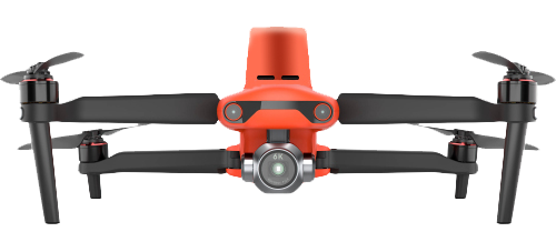
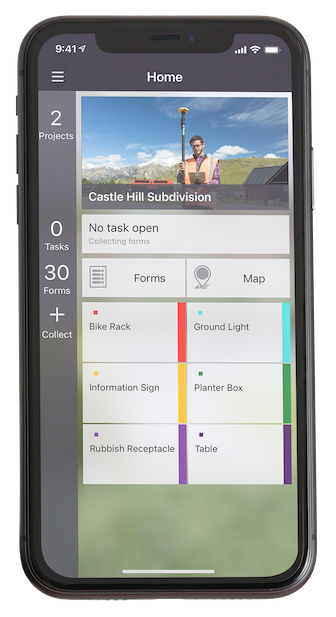
The Autel EVO II Pro RTK UAS. (Photo: Autel Robotics)
Carlson Software and Autel Robotics are partnering on the Autel EVO II Pro Series drone to provide drone operators with the opportunity to use the full suite of Carlson’s software and hardware solutions.
“We can take you through the entire project lifecycle, from setting your ground control points with a BRx7 GNSS receiver and RT4 data collector with SurvPC field software to the actual drone flight to the photo processing on your computer or in the cloud, all the way through to processing that data, creating linework, surfaces, and finished plans in CAD with our powerful, industry-standard office software,” said Derek Roché, Carlson regional manager.
Carlson’s tools for UAS professionals include:
Carlson PhotoCapture, a standalone or cloud-based photogrammetry software to create point clouds, orthoimages, surfaces and more from drone photo data
Carlson Point Cloud office software, which provides powerful tools such as bare-earth and automated feature extraction for point clouds
Carlson’s suite of CAD office software, including the Carlson Survey program to create finished CAD files and plans
Carlson BRx7 GNSS receiver, which can be used both to accurately place ground-control points and as a base to provide corrections to an Autel EVO II Pro RTK drone through Carlson’s Listen-Listen network.
“The workflow capabilities Carlson already has in place present an excellent choice for land development professionals, and now with the addition of the Autel EVO II series to handle the aerial data collection, we’re proud to offer the most comprehensive option in the industry today.”
In 2015, Autel Robotics released its first-generation UAS product: the X-STAR. The success of the X-STAR and the subsequent EVO II series allowed Autel Robotics to quickly build a reputation in U.S. markets. With the introduction of the EVO II series and platform in 2020, Autel Robotics will push its folding UAS to new heights in performance and application.
Carlson specializes in land surveying, construction, engineering, mining, machine control, and CSI solutions for professionals worldwide. In business since 1983, Carlson’s approach has always been to provide its customers with the most efficient, specialized, and powerful tools possible, backed by the best free, unlimited support in the industry.
Visit Carlson’s Autel EVO II RTK product page here, or find your Carlson sales representative or authorized dealer here.
Onocoy has launched a project to provide a dense network of community-powered GNSS reference stations. Based on Web 3.0 and an innovative incentive program, onocoy’s project strives to ensure outstanding positioning data quality suitable for mass market applications such as drones, micro-mobility, robotic lawnmowers or autonomous vehicles.
In the past, ultra-precise GNSS navigation with real-time kinematics (RTK) was only available to high-end markets because of prohibitive costs. With increasing demand for higher accuracies and advances in receiver technology, along with the availability of new GNSS signals, RTK receiver prices have dropped, yet high correction service costs and insufficient business models for mass markets have limited large-scale application of RTK.
Onocoy’s project aims to provide scalable correction services by leveraging Web 3.0 methods and distributed ledger technology. Such technology will facilitate a decentralized approach to the number of GNSS reference stations, 20 times the density as exist now. Ultra-dense distribution of GNSS reference stations will allow global access to instant centimeter-level positioning.
“Utilizing Web 3.0 methods with distributed ledgers and smart contracts, onocoy is poised to create the world’s densest distribution of GNSS reference stations that will enable RTK positioning anywhere,” said Daniel Ammann, initiator of the onocoy project. “By applying an open governance system, the interests of all stakeholders are taken into account in a transparent manner, ensuring that the project effectively addresses the needs of the stakeholders.”
The project will enable users to have the highest quality in GNSS data thanks to rigorous data validation and an innovative incentive scheme for data miners, where high-quality data is rewarded. Costs will be kept at a minimum with cutting-edge technology implementation and the wide user base. As a result, users will have the freedom to shape their solution to fit their market’s needs.
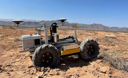
The CivDot UGV marks thousands of coordinates per day precisely and efficiently
Trimble Ventures, Trimble’s corporate venture capital fund, is investing in Civ Robotics, a San Francisco-based construction tech startup focusing on transforming surveying layout for civil engineering and infrastructure projects.
The investment supports Trimble Ventures’ mission to invest in early and growth-stage companies that are accelerating innovation, digital transformation and sustainability in the industries Trimble serves: agriculture, construction, geospatial and transportation. The investment terms were not disclosed.
The construction industry faces a variety of challenges including shortage of skilled workers, safety and productivity. Civ Robotics addresses these challenges with CivDot, a new autonomous surveying solution that empowers efficiency, productivity and safety on the job.
CivDot is an unmanned ground vehicle (UGV) designed for civil engineering and infrastructure projects such as solar farms, roadways, data centers, power plants and more. Augmenting the surveyor’s work, CivDot marks thousands of coordinates per day precisely and efficiently, while delivering layouts faster than traditional methods.
“We are focused on investing in companies that are seeking to address important challenges in markets that align with Trimble’s mission of transforming the way the world works,” said Aviad Almagor, vice president of technology innovation at Trimble and technology advisor for Trimble Ventures. “Civ Robotics technology supports surveyors and field workers and helps remove the burden of repetitive and risky work.”
Civ Robotics uses Trimble’s high-precision GNSS positioning technology and surveying software to improve productivity and increase safety, Almagor said. “This is an exciting opportunity to help accelerate innovation in autonomy, surveying and construction.”
“Trimble and our vision are in lockstep towards construction automation with a sharp focus on the highest standards of safety and quality,” said Tom Yeshurun, co-founder and CEO, Civ Robotics, which announced its $5 million seed funding round this morning. “Through Trimble’s latest GNSS technology in our autonomous surveying products, our customers can benefit from an end-to-end workflow.”
Civ Robotics will be showcased at the Trimble Dimensions+ User Conference, taking place Nov. 7-9 in Las Vegas.
The CivDot UGV, equipped with Trimble high-precision GNSS. (Photo: Civ Robotics)
An interview with Chris Trevillian, director of product management, geospatial GNSS at Trimble about recent GNSS receiver innovations.
Trevillian
What was the most significant technical innovation in your GNSS receivers in the past five years?
In 2019, Trimble broke ground with Trimble ProPoint, the fifth generation high-precision positioning engine, engineered to provide position and orientation data from the fusion of GNSS signals, globally accessible high-accuracy correction services, and measurement data from a variety of sensors.
When Trimble launched ProPoint signal processing with the Trimble R12 GNSS receiver, head-to-head testing with the Trimble R10-2 in challenging GNSS environments (near canopy and built environment) showed the R12 performed 30% better across a variety of factors, including time to achieve survey precision levels, position accuracy and measurement reliability.
In September 2020, Trimble announced the Trimble R12i GNSS receiver. It incorporates tilt compensation based on an IMU using Trimble TIP technology, which enables points to be measured or staked out while the survey rod is tilted. This empowers land surveyors to focus on the job at hand and complete work faster and more accurately.
What has it enabled users to do that they could not do before?
ProPoint provides new levels of reliability and productivity. In addition, the ProPoint engine is a key enabler of the new TIP technology.
The combination of ProPoint and TIP in the Trimble R12i allows users to accurately mark and measure points in areas previously inaccessible for GNSS rovers, such as building corners, or hazardous situations, such as the edge of an open excavation. The R12i also features real-time automatic inertial navigation system (INS) integrity monitoring. This system allows users to detect and correct for IMU biases introduced by use over time, temperature or physical shocks, helping ensure measurement quality and integrity for the life of the receiver. The combination of ProPoint and TIP technology improves accuracy, increases availability, provides better integrity and enhances constellation support.
Available on Trimble products utilizing Maxwell 7 technology, ProPoint leverages the latest developments in GNSS signal infrastructure and Trimble’s high-precision receiver hardware to deliver improved positioning performance in challenging environments. It also contains dynamic models of specific application movements, allowing it to filter out unexpected dynamic movements for improved accuracy.
What is a good example of this?
Benchmark Surveys, a small firm in Southwest England, wanted to test the R12i’s capabilities on a narrow road between an industrial park and Exeter Airport lined with high hedges, thick tangled foliage and large trees. The road-widening project, which required surveying 10 meters on either side of the road, would have been a challenge for any combination of surveying equipment. James Richards, Land, Utility and Measured Building Surveyor with Benchmark Surveys, told us the R12i was able to fix and gather points “in places not accessible by other GNSS kits we’ve used.” He said, “With the tilt compensation, we could reach under the edge of hedges and shrubs, up against buildings and walls, and safely out into the road.”
Trimble has released the Trimble TerraFlex Premium edition, a new tier of Trimble’s flagship geographic information system (GIS) data-collection software. The edition provides customers with offline GNSS corrections.
The new automated service works exclusively with Trimble GNSS receivers — including the Trimble DA2 receiver for the Trimble Catalyst positioning service — to provide high-accuracy GIS data capture in a wider range of locations and difficult GNSS environments than was previously possible.
TerraFlex users can increase the quality and speed of their data collection using offline GNSS corrections in situations where real-time services are intermittent or unavailable. Using the new service, all data from the field is automatically processed in the cloud without user intervention.
The most accurate real-time or offline processed position is stored for each feature, unlocking a high-productivity enhancement for all TerraFlex Premium subscribers.
Combining data-collection software and offline GNSS corrections into a single TerraFlex subscription simplifies both the workflow and the purchasing process for GIS organizations, from state and local governments to enterprise customers, including federal governments and utilities companies. This workflow to collect, process and deliver the most accurate and reliable positioning information reduces complicated manual processing steps and helps preserve data integrity.
Photo: Trimble
Streamlined post-processing using TerraFlex offline GNSS corrections is also available to Esri ArcGIS users, with the new Trimble Terra Office add-in for the Esri ArcMap GIS application. The new add-in replaces both the Trimble Positions Desktop and Trimble TerraFlex Desktop add-ins and supports offline GNSS corrections as well as existing desktop post-processing workflows. Terra Office is available as a yearly subscription.
“With Trimble offline GNSS corrections, we’ve taken the manual steps out of post-processing and made it as effortless as possible,” said Gareth Gibson, marketing director, Trimble Mapping and GIS. “This workflow enables TerraFlex customers to expand the locations and environments in which they work while still achieving high-accuracy results, and all without needing to become a GNSS expert.”
The TerraFlex Premium edition subscription is available through Trimble Geospatial Distribution Partners.
The TerraFlex offline GNSS corrections service uses a network of community base stations, and is broadly available in North America, the United Kingdom, Europe, Australia and New Zealand.
The Trimble Terra Office add-in for Esri ArcMap software is available through Trimble Geospatial Distribution Partners.
Expanded Construction One Portfolio enables an end-to-end digital experience for heavy civil and infrastructure contractors to enhance productivity, profitability and sustainability
Trimble has acquired privately held B2W Software, a provider of estimating and operations solutions for the heavy civil construction industry. Financial terms were not disclosed.
With the passage of the U.S. Infrastructure Investment and Jobs Act (IIJA) and other infrastructure legislation across the globe, construction organizations are fast-tracking the digitization of their processes and operations. As infrastructure projects become increasingly complex, data-driven insights and analytics will be imperative to improve productivity, increase efficiency and drive sustainability.
“Seamlessly connected workflows are key to unlocking the true potential of an organization’s data,” said Elwyn McLachlan, vice president of Trimble’s Civil Solutions Division. “With the acquisition of B2W, Trimble will be able to provide an unparalleled end-to-end digital experience — connecting the digital to the physical — for heavy civil and infrastructure contractors.”
The addition of B2W’s comprehensive suite of pre-construction and operations capabilities will expand Trimble’s already extensive civil infrastructure portfolio and Trimble Construction One, a purpose-built connected construction management platform.
Photo: Trimble
B2W’s integrated suite of applications includes estimating, scheduling, field tracking, equipment maintenance, data capture and business intelligence. By combining these capabilities with Trimble’s field data, project management, finance and human capital management solutions, civil contractors will be able to bridge the gap between office and field in new ways, promoting transparency, efficiency and ultimately profitability.
“B2W has helped thousands of heavy civil contractors increase their bid accuracy and operational efficiency,” said Paul McKeon, B2W founder and CEO. “Now with Trimble, we can realize the next chapter of our story. By linking the planned with the executed, we will provide civil contractors with a truly connected construction experience, unlocking valuable new insights for our customers across their entire operation.”
B2W will be reported as part of the Buildings and Infrastructure segment.
Perkins Coie LLP acted as legal advisor to Trimble. Piper Sandler & Co. acted as a financial advisor and Foley Hoag LLP acted as legal advisor to B2W Software.
An interview with Rachel Wong, product manager, surveying and engineering division at CHC Navigation about recent GNSS receiver innovations.
Wong
What was the most significant technical innovation in your GNSS receivers in the past five years?
CHC Navigation is a technology enabler for geospatial professionals in more than 120 countries. End users of geospatial data increasingly come from diverse backgrounds. This forces us to invest heavily in simplifying data-acquisition processes by focusing on the user friendliness and positioning reliability of our GNSS receivers.
The latest technological developments in GNSS real-time kinematic (RTK) rovers are based on the maturity and improvement of satellite navigation systems, as well as on the integration of IMU sensors in the receivers — the latter being certainly the most important innovation.
In addition, the latest generation of our GNSS rovers, such as the CHCNAV i83, is based on the sophisticated iStar algorithm, which significantly improves the efficiency of tracking GNSS satellite signals for unmatched performance in GPS, GLONASS, BeiDou, Galileo and QZSS constellations, using all available frequencies including BeiDou 3. This goes hand-in-hand with the integration of the IMU as it helps to ensure increased GNSS positioning accuracy through optimized satellite geometry.
What has it enabled users to do that they could not do before?
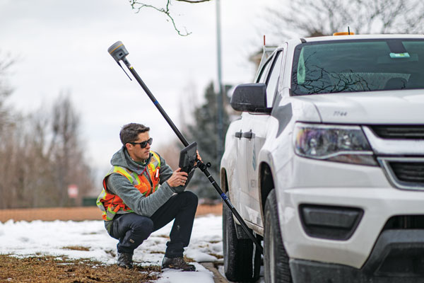
A utility worker uses the tilt-pole-compensation feature to measure a manhole. (Photo: CHC Navigation)
The integration of GNSS+IMU modules allows surveyors to survey points without the need to level the range pole, accelerating the adoption of GNSS technologies for early adopters by simplifying work processes. For example, our i83 GNSS is powered by a 1,408-channel multiband GNSS receiver, the latest iStar technology and a high-end, calibration-free IMU sensor for faster, more reliable GNSS field surveys.
The i83 GNSS’ integrated IMU automatically compensates for pole tilt, increasing surveying, engineering and mapping efficiency by 30% over conventional RTK GNSS surveying methods. In less than 5 seconds, the 200-Hz inertial module is initialized to ensure survey-grade accuracy over a pole-tilt range of up to 30 degrees that meets the real-world operational needs of our users.
What is a good example of this?
Surveyors can extend their working boundaries near trees, walls and buildings without the need for a total station or offset measuring tools. This can be illustrated in sewer and drainage applications, such as measuring the bottom of manholes for water, utilities or sewers, which was barely feasible in terms of GNSS measurement before the advent of hybrid GNSS + IMU positioning.
Operators only need to concentrate on their tasks and no longer need to level their pole vertically. They are now able to perform many measurements without compromising accuracy and reliability. Productivity is greatly increased, RTK usability is greatly improved, and potential human error is reduced, whether you are an engineer, foreman or surveyor, and whether you are an experienced or new user.
According to Fact.MR, a market research and competitive intelligence provider, the global surveying and mapping services market was worth US$9 billion in 2021 and is expected to expand at a CAGR of 3% during the forecast years of 2022-2032.
The survey and mapping industry has significantly benefited from drone technologies, because UAVs are less expensive and more accessible compared to traditional methods. Conventional surveying methods require rental aircraft and trained pilots, along with attached recording instruments — a costly and resource-intensive process. The introduction of UAVs has substantially created a future opportunity for surveying and mapping services to gather spatial information in a tighter structure. This also allows the collection of geospatial information with easy storage, processing and sharing capabilities.
For instance, in May 2022, India-based software company PDRL introduced a software-as-a-service platform — DroneNaksha — under the Svamitva Yojana scheme by the government of India for mapping land parcels using drone technology across the country. Similarly, in March 2022, Australia-based Emesent introduced Hovermap ST autonomous drone lidar mapping and surveying payload.
The integration of advanced technologies such as Wi-Fi, first-person view cameras, and GPS technology to make UAVs highly flexible and eliminate the need for a skilled pilot is expected to stimulate the demand for drones for survey and mapping activities, thereby driving market expansion.
Key Takeaways
The global surveying and mapping services market is projected to expand at a CAGR of 3.4% and reach US$13 billion by 2032.
Over the 2017-2021 historical period, the market evolved at 3.2% CAGR.
Forestry and agriculture account for a leading share in the market at a valuation of US$1.80 billion in 2021.
North America and East Asia account for leading shares in the global mapping services market at 24% and 32%, respectively.
A roundup of recent products in the GNSS and inertial positioning industry from the September 2022 issue of GPS World magazine.
OEM
Receiver Upgrade
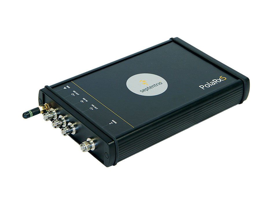
OSNMA anti-spoofing tech now on PolaRx5 GNSS reference receivers
Photo: Septentrio
Open Service Navigation Message Authentication (OSNMA) is now available on the high-end PolaRx5 reference receiver series. OSNMA offers end-to-end authentication on Galileo’s civilian signals, protecting receivers from GNSS spoofing attacks. OSNMA adds another layer of security to the receivers’ existing AIM+ anti-jamming and anti-spoofing technology. The PolaRx5 product range also now supports RINEX format versions 3.05 and 4.0.
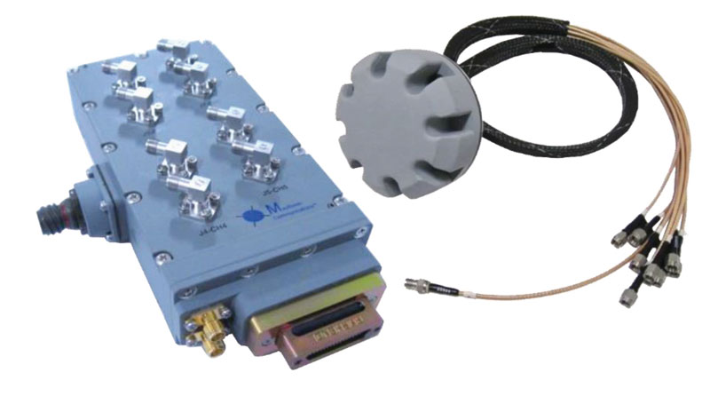
The MAGNA-F and MAGNA-I GPS anti-jam antennas provide simultaneous L1/L2 protection and can protect commercial and military GPS receivers on aircraft. The MAGNA products were developed with sponsorship by the U.S. Navy and further improved by the U.S. Army to support GPS protection requirements for air, sea and ground platforms, such as fixed-wing/rotary aircraft, ships, UAVs and tactical vehicles. The MAGNA-F uses a 3.5-inch-diameter controlled reception pattern antenna (CRPA) compatible with existing fixed radiation pattern antenna (FRPA) footprints. The MAGNA-I (NavGuard 730) is a high-performance yet small GPS anti-jam integrated solution with a 4.5-inch diameter FRPA-compatible footprint.
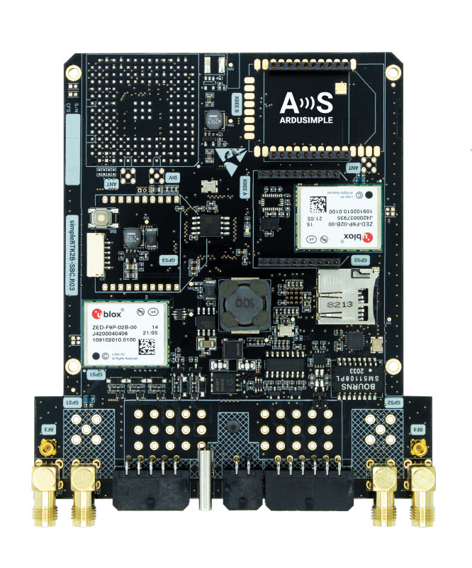
Centimeter-level GNSS for mass-market applications
Photo: ArduSimple
The SimpleRTK2B single-board computer (SBC) is built around up to three u-blox ZED-F9P high-precision GNSS receivers. It simplifies development of centimeter-level positioning solutions supporting real-time kinematics (RTK), making the technology accessible to broader audiences. The SimpleRTK2B-SBC was developed to make RTK technology as close to plug-and-play as possible. In addition to working as a stand-alone solution, customers can program their own applications with the company’s microPython API. The SimpleRTK2B-SBC delivers mechanical integration with centimeter position on three axes (heading, pitch and roll), outputting on NMEA, RTCM, RS232 and CANBus interfaces via Ethernet, Bluetooth, Wi-Fi and 2G/3G/4G communication. It offers configurable input/output and an inertial measurement unit.
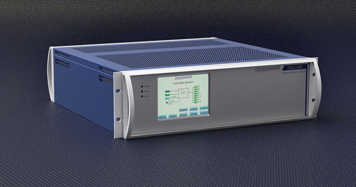
For assured positioning, navigation and timing (PNT)
Photo: ADVA
The OSA 3300-HP is a high-performance optical cesium clock with a 10-year lifetime compared to the five-year lifetimes of high-performance magnetic clocks. It provides the resilience required for PNT assurance in critical infrastructure and empowers service providers to deliver differentiated service-level-agreement timing offerings with integrated GNSS backup. The OSA 3300-HP has embedded Ethernet- and IP-based management as well as a user-friendly touchscreen graphical user interface.
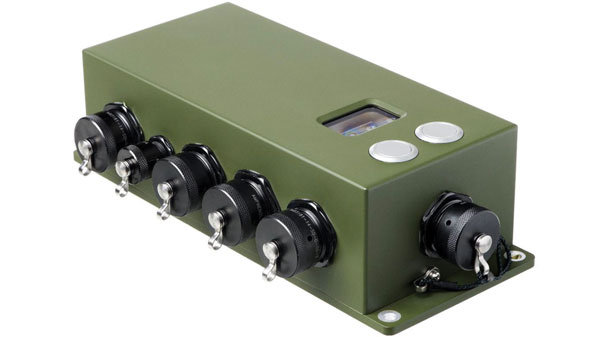
With M-Code capabilities and upgrade paths for other GNSS systems
Photo: Collins Aerospace
NavHub-200M is a vehicle navigation system for the international market with military code (M-code) receiver capabilities. NavHub-200M provides assured positioning, navigation and timing (APNT) while improving overall resistance to threats to GPS, such as jamming and spoofing. Its message formats and signal modulation techniques ensure faster and more accurate performance for ground vehicles on the connected battlespace, while advanced security features prevent unauthorized access or exploitation. NavHub-200M also includes the open interface standards and sensor-fusion capabilities required for a GNSS upgrade path, such as that for Europe’s Galileo constellation, as well as the ability to interface with key vehicle sensors such as the inertial measurement unit (IMU) and odometer.
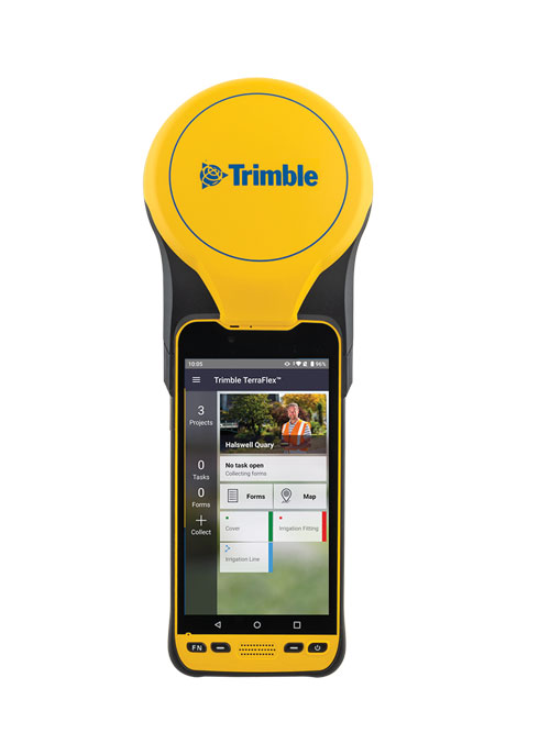
The Trimble TDC650 handheld is built for data collection, inspection and asset management activities. The rugged solution provides scalable high-accuracy GNSS positioning for professional field workflows, including apps such as Esri ArcGIS Field Maps and Trimble TerraFlex software. The TDC650 is scalable, allowing customers to choose their desired accuracy down to the centimeter level.
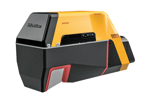
Powerful solution for manned and unmanned aircraft
Photo: YellowScan
The Voyager long-range lidar scanner has a wide field of view, with all points collected oriented toward the ground so there is no loss of points. In all, 1.5 million points per second will be usable. Voyager combines a Riegl VUX-120 laser scanner with a Trimble Applanix AP+ 50 AIR or Applanix AP+ 30 AIR GNSS-inertial board, providing a precision of 0.5 cm and an accuracy of 1 cm. Voyager’s detection and processing of up to 15 target echoes per laser pulse allows for excellent vegetation penetration. It has an extremely fast data-acquisition rate of up to 1,800 kHz, suitable for projects requiring the highest point density. The laser scanner’s specifications can be customized and can be combined with YellowScan’s software solutions.
Extends 3D Tiles Next workflow into Esri ArcGIS Pro
Photo: ArcGIS
The 3D Environments Add-In application for Esri ArcGIS Pro allows ArcGIS users to rapidly transform 3D Tiles Next data formats, such as One World Terrain, into ArcGIS Pro projects to create 3D scenes from 2D vector data and 3D models. The add-in leverages Presagis’ building templates and texture libraries that analysts use to create enhanced 3D visualizations of GIS environments, helping increase collaboration across the enterprise. The 3D Environments Add-In contains tools to create, transform and extract a wide variety of 3D formats to provide seamless interoperability between ArcGIS Pro and modeling and simulation applications. It is available on the Esri ArcGIS Marketplace.
Energy performance data helps tackle climate change
Photo: XMAP
Municipal geographic information system XMAP can now incorporate the energy-performance ratings of individual properties to help local authorities tackle climate change, improve housing standards, and ensure landlords comply with legislation. The Energy Performance Certificate (EPC) data layer uses a rating system similar to the one used on new appliances, ranging from A (very efficient) to G (inefficient). It allows tenants and house buyers to make informed decisions. In addition to a color-coded visualization of current ratings, the XMAP EPC layer contains enhanced analysis including generalized ratings and the potential for improvement. Bath and North East Somerset Council, UK (pictured), has embraced this resource and is looking at how the data can be used to raise housing standards.
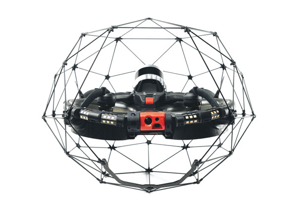
The Elios 3 is a collision-tolerant drone equipped with a lidar sensor for indoor 3D mapping. The drone is powered by a new SLAM engine called FlyAware that lets it create 3D models as it flies. It also hosts a new version of Flyability’s software for inspectors, Inspector 4.0. The Elios 3 comes with an Ouster OS0-32 lidar sensor, allowing inspectors to collect data for the creation of survey-grade 3D models using Connect software from Flyability’s partner GeoSLAM. Protected by a cage, the Elios 3 has advanced collision-tolerance features that allow inspectors to fly it inside dangerous confined spaces such as boilers, pressure vessels and mines.
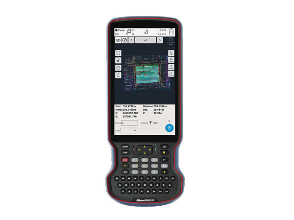
The R60 is a powerful handheld with an ergonomic design. It runs on Android 12 OS, providing a suitable workhorse for surveying professionals in the field. Survey Master field software works seamlessly on the R60, which features a Qualcomm 8-core processor for massive data processing. Its 64-GB memory allows ample data storage and enables the opening of CAD drawings in seconds. Other features include a QWERTY keyboard, a 5.5-inch sunlight-readable high-resolution screen, an IP67 rating (dustproof and waterproof), and a 9,000 mA Li-ion battery for more than 30 hours of continuous functioning.
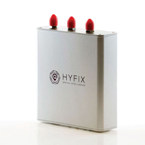
The Mobile Centimeter (MobileCM) Space Weather Station is a ready-to-use GNSS device that will act as a real-time kinematic (RTK) base station and collect space weather data. The device is pre-configured to securely connect with the Global Earth Observation Decentralized Network (GEODNET) using a home Wi-Fi network. The full four-constellation GNSS base station has built-in NTRIP server functionality and is packaged with a survey-grade triple-band roof antenna and required cables.
The SAgro10 GNSS guidance system is an entry-level guidance system for precision agriculture, providing users with higher navigation precision and higher productivity, which can be upgraded to an automatic steering system. Embedded with a high-precision GNSS module, the SAgro10 system tracks all four global constellations. For users with network coverage or a UHF base station, the system provides centimeter-level accuracy navigation in real-time kinematic mode. In the absence of base stations, the SAgro10 system provides sub-meter navigation accuracy in single-point smoothing mode. Compatible with most agricultural tractors, its components can be installed within 15 minutes. The 10-inch sunlight-readable touchscreen has a clear and simple graphic interface.
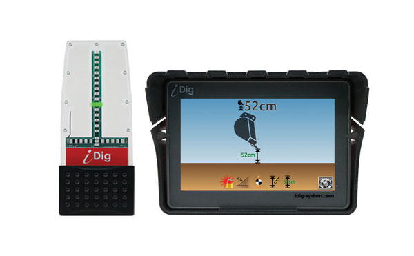
iDig 3D Connect is a solar-powered excavator guidance system with a GNSS receiver that can be removed and used as a rover, rather than permanently installed on the machine. 3D excavator guidance has seldom been used for small projects such as house foundations because of the need for a surveyor to stake out points and map a site. The removable receiver enables contractors to complete these tasks. The software provided creates a GNSS-generated site map, enabling precision digging relative to the area and making the process quicker, simpler and more eco-friendly than with 2D.
The Cloud Locator service takes data from LoRa Edge-enabled devices and uses Semtech’s LoRa Cloud Geolocation and Modem services for asset tracking both indoors and outdoors. It features built-in serverless technology and enables testing of ultra-low-power asset tracking on either a private or public LoRaWAN network. It is designed to work with trackers using Semtech’s LoRa Edge LR-series chips. The LR-series chips combine Wi-Fi and GNSS to obtain the latitude and longitude of devices in any indoor or outdoor location. Once configured on the service, together with Semtech’s LoRa wireless radio frequency technology for transmission to the cloud, customers can view the tracker location on a map in less than 15 minutes.
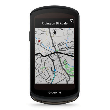
The Edge 1040 bike computer features solar charging and multi-band GNSS technology. Its multi-band GNSS receiver (GPS, GLONASS and Galileo) provides accurate positioning in challenging ride environments, such as dense urban areas or under deep tree cover. Advanced navigational tools help cyclists stay on track, such as turn-by-turn navigation and alerts that notify riders of sharp curves ahead. Route guidance and off-course notifications can be paused for exploring and turned back on for return to the original route. When using the Trailforks app, Forksight mode automatically displays upcoming forks in the route and where a rider is within a trail network.
Skydel 22.5 is a significant software upgrade to the Skydel simulation product line. It features advanced hardware-in-the-loop (HIL) testing solutions providing very low to zero effective latency. Enhanced visualization tools can monitor internal latency through real-time curves showing when the data is generated and sent to the RF signal. Users can also review the transmission of HIL packets for optimizing the entire network’s latency, checking its stability (jitter), and that data is available and used at the right time in Skydel. HIL testing is an essential step in the verification process of the model-based design approach because it involves all the hardware and software that will be used operationally.
The Time-Loader is designed for defense and mission-critical applications, for deployment in environments where GNSS signals are denied or disrupted. It supports any ground, naval or airborne system that needs real time of day (TOD) and 1PPS external synchronization aligned to the UTC or GNSS. It generates a GPS L1 C/A code RF output as if the signal were coming from a live-sky GPS antenna. It provides full-constellation GPS output and is compatible with external GNSS receivers. Its GPS-disciplined oscillator (GPSDO) is the Microsemi MAC-SA53/55, which provides excellent UTC accuracy with outstanding hold-over rubidium clock performance. A self-contained, miniature GPS simulator provides real-time extremely accurate signals. The 18-channel full-constellation simulator stores location/time/date data in internal memory and stores complex vector data to simulate dynamic scenarios. The simulator also can be used to transcode NMEA or SCPI position/ velocity/time (PVT) data into GPS RF signals.
Technology changes the rules of the game, and surveying may be more in its crosshairs than the profession will admit
Maps have existed for centuries. The lines on maps indicating the boundaries of political and administrative units — cities, counties, states, and countries — are graphic representations of the limits of those entities. These lines don’t, however, typically exist in real life. There isn’t a large line between the United States and Canada stretching from the Pacific Ocean, through the Great Lakes, and onto the Atlantic Ocean.
The same goes for latitude and longitude lines on maps and globes. The public generally accepts the various delineations on maps as being somewhat accurate with an unwritten level of trust in those who have produced these maps.
Definition
trust: assured reliance on the character, ability, strength, or truth of someone or something.
Here are the guidelines surveyors use for determining surveys.
lines physically verified in the field and proven from evidence
monuments and/or boundaries set and called for within legal descriptions
natural monuments
artificial monuments
adjoiners (to determine junior/senior rights)
courses
bearings, then distances (metes and bounds states)
distances, then bearings (public land survey states)
recitation of area
controlling description
evidentiary description
coordinates: local and/or geodetic
Surveyors rely on physical monuments, title documents and evidence of occupation to assist with the establishment of not just major dividing lines, but all lines of property, public or private. Finding, setting and honoring physical monuments has been a significant character trait of the surveyor for as long as maps have existed.
Monuments are placed to determine the endpoints of these lines as depicted on maps or plats, but what happens when technology introduces new ways to re-establish these lines? What will happen to our monuments when technology — more specifically those who utilize them — deems them obsolete?
The guidelines above are known as “priority of calls” or “rules of construction” by the surveying community. These items have provided the instructions for surveyors to follow in retracement of lines for many years. However, like nearly everything else in our modern world, technology has a hand in modernizing even this time-honored “surveyor’s code of retracement.”
Who would have guessed that the rotary phone dial would give way to touch-tone buttons, that the system would jump from landlines to cellular and satellite signals to remote handsets, then progress to receivers evolving away from physical buttons to touchscreens?
Technology changes the rules of the game, and surveying may be more in its crosshairs than the profession will admit.
Here come the numbers
Note that the last entry in the above guidelines for survey retracement is “coordinates.” In accordance with most accepted lists, coordinates can be local or geodetic. These coordinate values are generated by surveyors, geodesists and public agencies; they can be found on plats, and in records and websites kept by government agencies.
Now that we are more than two decades into the 21st century, it would be safe to say that most of the surveying profession uses an established geodetic coordinate system. The use of GNSS receivers is widely accepted as normal practice by many surveyors because these systems are much more user friendly than in years past. Additional constellations have added to the availability and accuracy of GNSS positional values, so utilizing state plane coordinates has become the norm.
We are now surrounded by something that has an incredible impact on our profession and the world around us. We are placing trust in a georeferenced coordinate system that cannot be identified by any of our senses, like we can with a physical monument.
A coordinate cannot be seen, touched, tasted, heard or smelled.
We are placing our full trust in a reliable position on Earth as determined by our GNSS receiver working within a published coordinate system. Because of these advancements in technology, a new generation of geospatialists is insisting we should revise the way we survey, because technology provides much higher precision and accuracy.
Just like lines on a map or plat, coordinates only exist as a calculation of a position on the face of Earth. So why is there animosity in trusting coordinates over the more traditional items on the list of retracement guidelines? It may have to do with the fact that the ground we are surveying is not in the same place it was a short time ago. Depending on where you live, it may have moved more than you think. For more information on the shifting ground we live on, let us dig into some research about our continents.
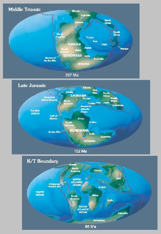
From about 300-200 million years ago (late Paleozoic Era until the very late Triassic), the continent we now know as North America was continuous with Africa, South America and Europe. They all existed as a single continent called Pangea. Pangea first began to be torn apart when a three-pronged fissure grew between Africa, South America and North America. Rifting began as magma welled up through the weakness in the crust, creating a volcanic rift zone. Volcanic eruptions spewed ash and volcanic debris across the landscape as these severed continent-sized fragments of Pangea diverged. The gash between the spreading continents gradually grew to form a new ocean basin, the Atlantic. The rift zone known as the mid-Atlantic ridge continued to provide the raw volcanic materials for the expanding ocean basin.
Meanwhile, North America was slowly pushed westward away from the rift zone. The thick continental crust that made up the new east coast collapsed into a series of down-dropped fault blocks that roughly parallel today’s coastline. At first, the hot, faulted edge of the continent was high and buoyant relative to the new ocean basin. As the edge of North America moved away from the hot rift zone, it began to cool and subside beneath the new Atlantic Ocean. This once-active divergent plate boundary became the passive, trailing edge of westward moving North America. In plate tectonic terms, the Atlantic Plain is known as a classic example of a passive continental margin.
Today, the Mesozoic and Cenozoic sedimentary rock layers that lie beneath much of the coastal plain and fringing continental shelf remain nearly horizontal.
Image: USGS
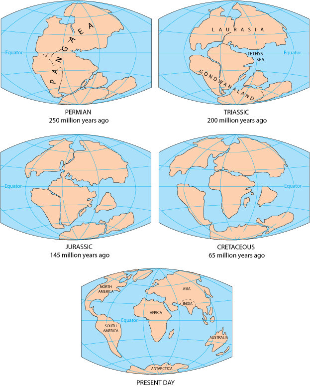
In geologic terms, a plate is a large, rigid slab of solid rock. The word tectonics comes from the Greek root “to build.” Putting these two words together, we get the term plate tectonics, which refers to how the Earth’s surface is built of plates.
The theory of plate tectonics states that the Earth’s outermost layer is fragmented into a dozen or more large and small plates that are moving relative to one another as they ride atop hotter, more mobile material. Before the advent of plate tectonics, however, some people already believed that the present-day continents were the fragmented pieces of pre-existing larger landmasses (“supercontinents”).
The diagrams below show the break-up of the supercontinent Pangaea (meaning “all lands” in Greek), which figured prominently in the theory of continental drift — the forerunner to the theory of plate tectonics.
Image: USGS
Continental drift, plate tectonics and prime meridians
Historians and other scientists have theorized about Pangea for centuries. Common soil types, fossils, and other evidence found on different continents help to solidify the concept of Pangea. Items discovered on the west coast of Africa have many similarities with those found on eastern South America. The physical evidence is quite convincing that an earlier supercontinent existed millions of years ago.
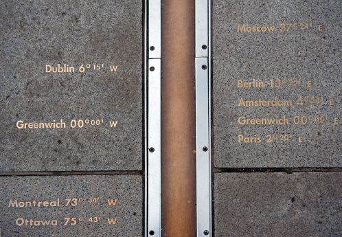
Now, let’s apply a fixed measurement system with lines upon Earth that defines latitude and longitude. In the past, geodesists, geographers and mathematicians established various “prime meridians” around the world to serve as a basis for maps. Locations and cities used included Amsterdam, Antwerp, the Bering Strait, Bern, Brussels, Copenhagen, Florence, Giza, Jerusalem, Kyoto, Lisbon, Madrid, Naples, Oslo, Paris, Philadelphia, Pisa, Rio de Janeiro, Rome, Stockholm, Warsaw and Washington, D.C. (in four different places!), just to name a few.
Thankfully, scientists gathered in the 19th century to agree upon a singular “initial meridian” that would pass through Greenwich, England, and was based upon several centuries of astronomical observations at the nearby Royal Observatory.
For approximately 100 years, mapmakers (and geodesists) used the new Prime Meridian at Greenwich as the beginning baseline for longitude determination around the world. After all, it was based upon years of astronomical observations and solved the age-old problem of where longitude starts. (Latitude was a much easier calculation for astronomers and geodesists, but that story is for another day.)
The late 20th century and the fourth industrial revolution
Technology, once again, provides us with conflicting results. While most technological advancements are game-changing improvements to mankind, they also tend to shake up information and standards that have existed for many generations. Like the previously discussed advancements in telephones, technology makes us change the way we look at things and how we go about our lives.
Mapping has become a central part of our everyday lives. Georeferenced positions for literally everything is now a standard characteristic of many functions within our environment, especially in our surveying world. Most of these improvements are due to GPS, which was originally developed for the U.S. military to guide and assist with positional location of our defense systems in relation to our enemies. We use this same precise technology to establish positional locations for boundary points, infrastructure and topographic information.
Image: Tim Burch
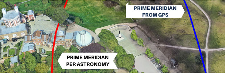
We have also used GPS to learn much about our tectonic plates and varying movement of the continents.The first thing we learned is that the Prime Meridian established in 1884 does not fall in the same place as our 0° latitude designation as determined by GPS/GNSS calculations.
This finding, however, is not the telling item within our adaptation of GPS data; it came when various agencies established the continuously operating reference system (CORS), composed of static GPS base stations. CORS stations, while used to help establish new survey positions in relation to a known reference location, also measure a continuous drift of latitude and longitude positions over time.
The National Geodetic Survey (NGS) is in the process of finalizing a new reference framework for establishing coordinate values that utilize time as a core component. Future implementation of the new National Spatial Reference System (NSRS) will require the additional attribute of time within the metadata of any new values.
So how does this affect surveying and the monuments we surveyors hold on such a high pedestal? The answer varies depending on who one asks. Most surveyors will continue to hold the “priority of calls” as listed above. Several practitioners, however, want to move coordinates higher up the list because of technology, and the ability to retrace a published point because of the increase in technology and the higher accuracy and precision of today’s GNSS.
This is possible if the user of the technology follows the procedures as established by NGS with metadata and accurate timing, but there are still several variables in the setting and retracing methodologies. When was the last time the equipment was calibrated? Was adequate research performed to minimize environmental errors? Was there any interference due to solar storms or multipath? There are many potential issues a surveyor can face, but few are checking all the boxes when performing highly accurate and precise positional measurements.
Technology has brought surveying into the 21st century with GPS/GNSS and ever-increasing accuracy and precision. It should also be the profession’s goal that the technology does not override what the general public can see. They can see monuments, fence lines, buildings and other improvements, but they cannot see coordinates, which remain invisible to the naked eye. Technology may change that in the future, too, but until that time, we must rely on what we can see.
Trimble is committing to reduce greenhouse gas emissions in line with the ambitious goals of the Paris Agreement and a net-zero future to keep global temperature increase to 1.5° C.
“Taking decisive climate action is essential to protect our planet and communities for future generations,” said Rob Painter, president and CEO, Trimble. “It also demonstrates Trimble’s commitment to our purpose — to transform the way the world works as well as transform the way ‘we’ work.”
“For decades, Trimble solutions have contributed to reducing greenhouse gas emissions and combating climate change,” Painter said. “The nature of Trimble’s technologies, which connect the physical and digital worlds, provides efficiencies and promotes sustainability in our end markets such as construction, agriculture, forestry, utilities and transportation. Our leadership team is committed to further reducing our carbon footprint as well as continuing to develop solutions that enable our customers to reduce their climate impacts — it is an important lever in our Connect and Scale strategy. Trimble is dedicated to do its part to help protect and build a better world.”
Trimble’s science-based targets accelerate decarbonization across its value chain, and include the following commitments:
reduce absolute scope 1 and 2 greenhouse gas emissions by 50 percent by 2030 from a 2019 base year
achieve 100 percent annual sourcing of renewable electricity by 2025
reduce absolute scope 3 greenhouse gas emissions from fuel and energy-related activities, business travel and upstream transportation and distribution by 50 percent by 2030 from a 2019 base year
commit to partner with 70 percent of its suppliers by emissions covering purchased goods and services and capital goods to set science-based targets by 2026.
“Setting ambitious yet achievable climate targets is part of our commitment to reducing Trimble’s carbon footprint,” said Leah Lambertson, senior vice president and head of Sustainability, Trimble. “Embedding our climate action goals into Trimble’s operational choices will help ensure that our decision making and growth plans are consistent with our low-carbon vision. Today’s commitments are important steps in our journey to delivering growth in a responsible and sustainable way to achieve a net-zero future.”
Trimble’s 2021 Sustainability Report
Trimble also announced the release of its 2021 Sustainability Report. Built around the company’s mission of transforming the way the world works, the report describes how Trimble is helping to create a better future for the planet and the communities it serves.
The report summarizes its initiatives and performance across environmental, social and governance (ESG) topics, highlighting the company’s sustainability approach; end-user industry solutions; community philanthropy through its Trimble Foundation Fund; employee engagement and development as well as diversity, equity and inclusion (DEI) initiatives; and governance.
ComNav Technology Ltd. has released the N2 Palm RTK GNSS receiver. The release coincides with the company’s 10th anniversary. With its advanced technologies, the N2 is suitable for surveying, mapping and construction.
The N2 has a highly integrated main board and a three-in-one antenna, yet is extremely thin and portable, weighing about the same as a basketball (0.72 kg with battery) and measuring 48 mm, the thickness of AirPods.
Powered by ComNav’s SinoGNSS K8 high-precision module, the N2 can track 1,590 channels, including all existing and planned signals of GPS, BDS-2, BDS-3, GLONASS, Galileo, QZSS and SBAS. Its advanced satellite-tracking technology ensures it works well even in harsh environments, such as under heavy foliage or close to buildings.
A third-generation inertial measurement unit (IMU) makes the N2 immune to magnetic disturbance, which greatly improves its reliability. Pole-tilt compensation of up to 60° allows surveyors to locate difficult points precisely and easily while maintaining positioning accuracy within 2.5 cm. By using the company’s Quantum algorithm, the N2 achieves calibration-free operation — after 10 seconds of initialization, users can make tilt measurements with centimeter-level accuracy for an extended period, greatly improving efficiency.
With its integrated UHF modem, the N2 can reach a working range of up to 15 km. It can be used as either a base station or a rover.
The N2 features a 10,000 mAh intelligent Li-ion battery, along with ComNav’s patented low-power-consumption technology. It fully charges in five hours and works continuously in the field for 20 hours. The built-in USB-C port makes it convenient to charge with standard smartphone chargers or external power banks.
As with ComNav’s other products, the N2 meets ComNav’s high quality and durability standards; it is rated IP67 (dustproof and waterproof) and can work in temperatures from –35° C to +65° C. It can be used in a wider range of outdoor working conditions.
With near-field communication (NFC), the N2 can connect to other NFC-enabled devices, such as the R60 data collector. V5.0 dual-mode Bluetooth inside allows users to connect at ultra-long distances with low energy requirements.
The N2 Palm RTK GNSS receiver now is available through ComNav Technology authorized local distributors or directly from ComNav Technology.