“Seen & Heard” is a monthly feature of GPS World magazine, traveling the world to capture interesting and unusual news stories involving the GNSS/PNT industry.
Photo: nattrass/iStock/Getty Images Plus
SMARTWATCH REVEALS RUNNER’S FATE
On the morning of July 10, Berkeley resident Philip Kreycik went for a run in Pleasanton, California. That day, temperatures reached 106 degrees, and he didn’t return home. His body was found Aug. 3, reports the San Francisco Chronicle. His Suunto smartwatch stopped tracking movement 4.5 hours after he started his run. GPS data from the watch showed him moving in erratic zigzags and circles before he stopped. Experts concluded he experienced delirium before succumbing to heat exhaustion.
Organized gangs riding e-scooters are stealing high-value GPS/GNSS technology from farms in the United Kingdom, reports BBC News. Insurer NFU Mutual said the cost of replacing the stolen equipment nearly doubled in a year to £2.9 million. The technology, in worldwide demand, has become the “rural thieves’ top target,” the insurer said. GPS/GNSS equipment on tractors can cost up to £10,000 per unit.
SPACE FORCE RECRUITS WITH GPS
A 13-minute recruitment commercial from the U.S. Space Force debuted Aug. 24, with GPS as a star. “There’s no such thing as a day without space operations. You just don’t see them,” explains the video, mentioning how GPS is key to the operation of ATMs, cell phones, gas pumps, traffic lights, power grids, guided missiles and more. The commercial states that the Space Force is seeking guardians who will help protect satellites from attack and debris. Current guardians describe the importance of GPS. “We won’t just think outside the box, we’ll think outside the atmosphere, in one of the most challenging environments ever known,” concludes the video. “The sky is not the limit.”
THIEVES STEAL TRACKERS AND… (GUESS THE REST)
Two burglars who stole a package from a drop-off box were quickly apprehended — the package was filled with Roambee GPS-based trackers heading to a COVID-19 vaccine maker for use in tracking shipments. The Santa Clara Police Department was ecstatic to learn what the thieves had stolen, reports Roambee, who knew the package had gone missing. Unaware of what was in their trunk, the thieves traveled more than 761 miles around the Bay Area before being arrested 14 days later on July 18.
Multiple leaders and technology experts from U.S. Army Futures Command are scheduled to speak at Fed Supernova 2021, an innovative defense technology conference that will take place online and at Austin’s Capital Factory Sept. 28-29.
Representatives from the command’s Army Applications Laboratory, Army Research Laboratory, Army Software Factory, Futures and Concepts Center, 75th Innovation Command and Austin-based headquarters will share insights on topics ranging from Joint Force software development initiatives to Army efforts to foster strategic industry partnerships that help bring promising new solutions to scale.
“Army Futures Command is dedicated to continuous innovation and broad collaboration. Events like Fed Supernova offer a unique opportunity for us to highlight recent wins while preparing for what’s next in the tech innovation space,” said Lt. Gen. Thomas Todd III, AFC deputy commanding general for Acquisitions and Systems and Chief Innovation Officer, who is scheduled to speak at the event.
Of the hundreds of papers researchers presented at 2020’s annual Institute of Navigation (ION) GNSS+ conference, which took place virtually Sept. 21–25, the following six focused on combating jamming and spoofing. The papers are available at www.ion.org/publications/browse.cfm.
Using Direction of Arrival
The author presents a scheme to combine multiple measurements for GNSS spoof detection for safety-of-life applications. The author’s algorithm combines both independent and correlated direction of arrival measurements that result in an analytic solution for the detection threshold, which can be computed online by the receiver. The scheme is validated for correlated azimuth measurements with data recorded by a dual-polarization antenna mounted on a C12 aircraft in flight, and applied to data from a live spoofing event. Results show an increase in detections of 47% using just two sequential measurements, with equal robustness for false alerts compared to snapshot-based detection. The results also show using sequential spoof detection is a powerful way to improve the detection capability of an anti-spoof defense, costing only added computational complexity while introducing a timely component to the detection.
Citation. Rothmaier, Fabian; “Optimal Sequential Spoof Detection Based on Direction of Arrival Measurements.” https://doi.org/10.33012/2020.17538
Using Neural Networks
Spoofing attacks are difficult to model and counteract. Data-driven schemes become useful if enough training data is available. This article explores such an approach using the cross-ambiguity function delay/Doppler map as input to a deep neural network for classification purposes. Several neural network models are trained, and their performance compared for detection and false-alarm probabilities. Results are promising, particularly with more complex neural networks, which are able to capture the nature of spoofing attacks. The method operates on a per-satellite basis.
Information cross-validation can be a powerful tool to detect manipulated, dubious GNSS timing data. Opportunistic time providers, Wi-Fi beacons and dedicated timing infrastructures provide largely available, precise sources of time information. A promising approach is to leverage time obtained over networks to which a mobile device can connect, and detect discrepancies between the GNSS-provided time and the network time. The paper investigates different options to secure augmentation time information, notably Network Time Security (NTS) and modified Wi-Fi beacons to support authentication. This scheme requires limited overhead, does not disrupt the normal operation of the Wi-Fi access points, and can be readily deployed.
Citation. Spanghero, Marco; Zhang, Kewei; Papadimitratos, Panagiotis; “Authenticated Time for Detecting GNSS Attacks.”
Using Cooperative Positioning
This paper highlights possible metrics to be checked to identify malicious attacks to the positioning and navigation systems in mass-market connected devices. The network-based exchange of GNSS data — such as GNSS raw measurements recently disclosed in Android smart devices — could offer the possibility to compare or combine such metrics to better identify spoofing and meaconing attacks.
This paper provides experimental tests and analysis toward devising an anti-spoofing strategy in connected GNSS devices. Included are a classical spoofing approach (simplistic RF attack) and its effects on the raw GNSS observables. With two synchronized devices in a cooperative framework, possible metrics are highlighted to identify a spoofing attack to one of the devices by observing anomalies.
Also included is work on simulated meaconing of an already-developed collaborative positioning framework based on the exchange of raw GNSS measurements through the network. The different approaches of an attack to the framework are laid down, and the anomalies to be considered to detect an attack in a network of cooperating devices are presented.
This paper represents a part of a larger goal to develop an anti-spoofing detection and coping mechanism in connected commercial GNSS devices.
Citation. Rustamov, Akmal; Gogoi, Neil; Minetto, Alex; Dovis, Fabio; “GNSS Anti-Spoofing Defense Based on Cooperative Positioning.”
Using OSNMA in the GIANO GNSS receiver
In recent years, the awareness about jamming and spoofing risks has been increasing, particularly in the timing community because they may cause the disruption of critical services and infrastructures in the telecommunication, energy and finance sectors, which rely on GNSS timing to operate. To overcome these hazards, the European GNSS Agency (GSA) has funded the development of timing receivers for professional applications, with the aim to address specifically the above vulnerabilities, improving the receiver’s robustness and the accuracy and reliability of time transfer.
In this context, the GIANO (Galileo-based timing receiver for critical infrastructures robustness) project consortium, coordinated by Thales Alenia Space Italy and with the support of Deimos Engenharia S.A. (Portugal), the Space Research Centre PAS in Poznan (Poland), Piktime System SP. Zoo (Poland) and Business Integration Partner S.p.A. (Italy), has been awarded a contract in the framework of the GSA’s “Fundamental Elements” program to develop a timing receiver for critical infrastructure applications. Besides the implementation of some interference and spoofing detection and mitigation techniques, the GIANO receiver makes use of Galileo’s authentication service OSNMA (Open Service Navigation Message Authentication), which can be employed as an added defense against some types of spoofing.
OSNMA exploits the TESLA (Time Efficient Stream Loss-tolerant Authentication) scheme, which is a protocol based on the transmission of message authentication codes generated with a key broadcast with some delay. The receiver authenticates the satellite messages through a digital signature algorithm and a public key known by the receivers, which also validates the root key of the TESLA chain, and through message authentication codes (MAC) used to authenticate specific fields of the navigation message. The receiver will also support public key renewals over the air.
This paper presents the OSNMA implementation within GIANO receiver, including the cryptographic operations required. The GIANO OSNMA capability will be extensively tested and validated with the support of the European Commission Joint Research Centre (Ispra, Italy).
Chimera is a signal authentication enhancement suitable for protecting the L1C GPS signal. As specified by the acronym itself (chips-message robust authentication), Chimera is based on the insertion of authentication features both at the message and spreading code levels. The data are digitally signed, while the spreading code is protected by the insertion of cryptographically generated punctures.
The Chimera interface specification document was made public in 2019, while its first transmission is expected to be broadcast from the Navigation Technology Satellite 3 (NTS-3) satellite, set for launch in 2023.
This paper describes the software implementation of the functions required to enable a GNSS software receiver to elaborate the Chimera authentication service. It includes a description of the development work and a detailed software profiling analysis, allowing for evaluation of the additional computational burden required by the Chimera verification and useful for providing important guidelines for receiver implementation.
Boeing will build the U.S. Navy’s MQ-25 Stingray unmanned aerial refueler at a new 300,000-square-foot facility at MidAmerica St. Louis Airport in Illinois. (Photo: Boeing)
Boeing will build the MQ-25 Stingray — the Navy’s first carrier-based unmanned aircraft — at a new high-tech facility in Illinois. The 300,000 square-foot facility at MidAmerica St. Louis Airport, Illinois, is scheduled for completion in 2024.
The MQ-25 facility will include state-of-the-art manufacturing processes and tools, including robotic automation and advanced assembly techniques, to improve product quality and employee ergonomics. The facility initially will employ 150 mechanics, engineers and support staff, but could grow to 300 with additional orders.
Boeing digitally engineered the entire MQ-25 aircraft and its systems, resulting in high-fidelity models used to drive quality, efficiency and flexibility throughout the production and sustainment process.
For two years, Boeing and the Navy have been flight testing the Boeing-owned MQ-25 test asset from MidAmerica Airport. In recent missions, the T1 model has refueled an F/A-18 Super Hornet, an E-2D Hawkeye and an F-35C Lightning II.
The U.S. Navy intends to procure more than 70 MQ-25 aircraft to help extend the range of the carrier air wing, and the majority of those will be built in the new facility. Boeing is producing the first seven MQ-25 aircraft, plus two ground test articles, at its St. Louis facilities, and they will be transported to MidAmerica for flight test. The MQ-25 program office, including its core engineering team, will remain based in St. Louis. MidAmerica is adjacent to Scott Air Force Base.
The new MQ-25 facility will be in addition to existing manufacturing operations at Boeing St. Clair, which produce components for the CH-47 Chinook, F/A-18 Super Hornet, F-15 and other defense products.
T1 Stingray refuels a Navy F/A-18. (Photo: U.S. Navy/Boeing)
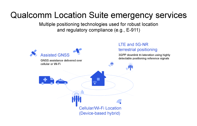
To comply with Federal Communications Commission (FCC) E-911 regulations, Qualcomm Technologies has enhanced its Qualcomm Location Suite to provide improved horizontal and vertical positioning information. The upgrade will help first responders better determine the floor within a multi-story building from which an emergency call was placed.
The Qualcomm Location Suite is deeply integrated with Qualcomm’s Snapdragon Mobile Platforms and Snapdragon Modem-RF Systems that power millions of mobile devices in the U.S. The suite has supported emergency location services in the U.S. and globally for two decades.
The change will help mobile service providers comply with new E-911 regulations requiring that the horizontal and vertical position of each wireless caller be determined with a certain level of precision.
The Qualcomm Location Suite uses GNSS with network-based positioning and dead reckoning to deliver accurate location with speed and efficiency. GNSS assistance is delivered over cellular or Wi-Fi, LTE and 5G-NR terrestrial positioning; cellular/Wi-Fi-based location is also provided.
When an emergency call comes in, operators rely on a combination of triangulation of wireless signals and device positioning technologies, such as GPS, to provide the position of the caller. The use of technologies in the Qualcomm Location Suite is designed to result in highly accurate positioning information and the ability to share this reliable information with first responders, allowing them to reach the precise emergency site more quickly.
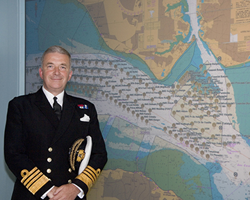
Admiral Lord Alan West of Spithead has served the United Kingdom as First Sea Lord and led the government’s efforts for counter terrorism and cybersecurity. He has been a member of the House of Lords since 2007 and has stayed engaged with defence and maritime issues. RNT Foundation President Dana A. Goward spoke with him in early September about the UK’s way forward for GPS-like services.
DG: The UK government has been talking for years about the nation’s vulnerability to disruption of space-based signals such as those from GPS and Galileo. What is being done about it?
LW: Unfortunately, the government is not being as transparent as we might like on this. I do know from comments made in the House of Lords that there is a group developing a strategy. Also, that the Cabinet Office — our equivalent of the National Security Council in the United States — is deciding who is to be in charge and how things will be run.
I have heard the strategy group will propose a mix of technologies such as has been discussed in the United States. The idea of having several different systems, I am sure, is so that something interfering with one won’t disrupt them all.
This is all supposed to published in November. But I am concerned that government distractions with COVID, Afghanistan and other issues will delay that.
DG: What about the OneWeb project? That doesn’t seem to be waiting for a November announcement. And there is talk it may provide GPS-like timing and navigation services.
LW: OneWeb is moving forward, but at present it is only about 5G and making it available more quickly and broadly. There may be a OneWeb Phase 2 that includes modified or additional satellites to provide positioning, navigation and timing (PNT), but that is to be decided.
Admiral Sir Alan West, then First Sea Lord, is pictured with the official chart of anchorages for the International Fleet Review. (Photo: DP Kilfeather’s book Trafalgar 200 Through the Lens, Queen Elizabeth II 80th Birthday Edition, CC BY-SA 2.5)
DG: How about the UK rejoining Galileo?
LW: Actually, that makes a lot of sense from a practical point of view for both the UK and Europe. Unfortunately, there were a lot of hurt feelings on the continent with Brexit, some EU leaders seemed to be in punishment mode, and expulsion from Galileo was part of the fallout. I think that in due course as tempers cool, we will fully re-engage with the European Space Agency.
DG: So, no UK project for a GPS equivalent?
LW: The government allocated £90 million to that, which enabled a thorough look at the idea but was woefully inadequate to even start a project. Doing a British version of GPS or Galileo would be hugely expensive and doesn’t make sense. There are better, cheaper ways of getting what we need.
DG: And what does the UK need? What is the goal?
LW: We need several things.
First, we need a global capability that is ours, or that we are closely partnered in, to support the UK’s worldwide military and economic interests.
We also need to have something in place so that, even if space is denied to us — and that is getting to be more and more of a threat each day — we can keep our industries, critical infrastructure and economy going at home.
And third, we need a resilient PNT capability as a foundation for current applications, and to build on for such things as autonomy, intelligent transportation, and the like.
DG: So how do you get there?
LW: For the global bit, the OneWeb, and perhaps an even closer partnership with the United States on GPS.
At home, we definitely need a sovereign capability for when space is denied by solar weather or our adversaries. Also to be a check on space signals because our adversaries and criminals are spoofing them more and more.
I have always thought eLoran was a good choice. The UK pioneered its development and had the world’s first operational system in 2015. It is really hard to interfere with the signal, and there are other features that could be added to it that would make it even more robust.
There was a very interesting report called MarRINav put out last year about what UK maritime needs to ensure it can navigate regardless of whether the satellites are working or not. They came up with a reasonably inexpensive combination of systems anchored by eLoran.
By the way, it is interesting that the MarRINav study was funded by the European Space Agency. They seem to understand that satellites are not the be all and end all for PNT services.
DG: That all seems pretty straightforward and the right thing to do. What’s standing in the way?
LW: Well, so few people understand the problem. The population as a whole is almost completely unaware. At some level government understands all 13 of our critical infrastructure sectors could be impacted, but the people senior enough to drive action have dozens of other issues to deal with that probably seem more urgent.
DG: I wonder what it will take to make it seem urgent enough.
LW: Let’s hope the wakeup call is something short of a national disaster.
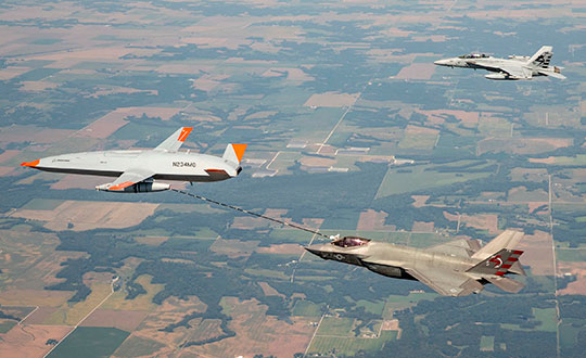
An unmanned MQ-25 T1 test asset refueled a third U.S. Navy carrier-based aircraft, demonstrating the maturity of the aircraft’s design and performance
The U.S. Navy and Boeing used the MQ-25 T1 test asset on Sept. 13 to refuel a U.S. Navy F-35C Lightning II fighter jet for the first time, demonstrating the aircraft’s ability to achieve its primary aerial refueling mission.
This was the third refueling mission for the Boeing-owned test asset in just over three months, advancing the test program for the Navy’s first operational carrier-based unmanned aircraft. T1 refueled an F/A-18 Super Hornet in June and an E-2D Hawkeye in August.
“Every test flight with another type/model/series aircraft gets us one step closer to rapidly delivering a fully mission-capable MQ-25 to the fleet,” said Capt. Chad Reed, the Navy’s Unmanned Carrier Aviation program manager. “Stingray’s unmatched refueling capability is going to increase the Navy’s power projection and provide operational flexibility to the Carrier Strike Group commanders.”
During a test flight on Sept. 13, an F-35C test pilot from the Navy’s Air Test and Evaluation Squadron Two Three (VX-23) conducted a successful wake survey behind T1 to ensure performance and stability before making contact with T1’s aerial refueling drogue and receiving fuel.
“This flight was yet another physical demonstration of the maturity and stability of the MQ-25 aircraft design,” said Dave Bujold, Boeing’s MQ-25 program director. “Thanks to this latest mission in our accelerated test program, we are confident the MQ-25 aircraft we are building right now will meet the Navy’s primary requirement — delivering fuel safely to the carrier air wing.”
The T1 flight test program began in September 2019 with the aircraft’s first flight. In the following two years, the test program completed more than 120 flight hours — gathering data on everything from aircraft performance to propulsion dynamics to structural loads and flutter testing for strength and stability.
MQ-25 is benefitting from the two years of early flight test data, which has been integrated back into its digital models to strengthen the digital thread connecting aircraft design, production, test, operations and sustainment.
T1 will be used to conduct a deck handling demonstration aboard a U.S. Navy carrier in the coming months to help advance the carrier integration progress.
Boeing’s MQ-25 T1 test asset transfers fuel to a U.S. Navy F-35C Lightning II fighter jet Sept. 13 during a flight-test mission. The Navy and Boeing have conducted three refueling flights in the past three months, including an F/A-18 Super Hornet and E-2D Hawkeye. (Photo: Kevin Flynn/Boeing)
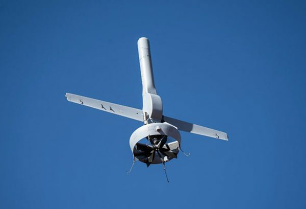
Northrop Grumman and Martin UAV (a Shield AI company) have completed successful flight testing of a V-BAT unmanned aircraft system (UAS) with new features including GPS-denied navigation and target designation capabilities.
The enhanced V-BAT’s flexible vertical take-off and landing (VTOL) capability is based on a platform deployed to address the U.S. Army’s Future Tactical Unmanned Aircraft System (FTUAS) mission. For FTUAS, the U.S. Army is seeking a rapidly deployable, GPS-denied navigation-capable, expeditionary VTOL system capable of persistent aerial reconnaissance for U.S. Army brigade combat teams, special forces, and Ranger battalions.
The offering is based on Martin’s UAV V-BAT UAS. According to Northrop Grumman, it is compact, lightweight, simple to operate, and can be set up, launched and recovered by a two-soldier team in confined environments. The V-BAT also is designed with sufficient payload capacity to carry a range of interchangeable payloads, including electro-optical/infrared (EO/IR), synthetic aperture radar (SAR), and electronic warfare (EW) payloads, depending on mission-specific requirements. Additionally, Shield AI’s recent acquisition of Martin UAV will enable rapid development of GPS-denied and autonomy capabilities for V-BAT through the future porting of Shield AI’s autonomy stack, Hivemind, onto V-BAT.
Northrop Grumman and Martin UAV conduct flight testing of Martin UAV’s V-BAT aircraft for the U.S. Army’s Future Tactical Unmanned Aircraft System effort in Camp Grafton, North Dakota. (Photo: Northrop Grumman)
The Air Wolf just prior to Burns Flat dawn launch. (Photo: Kratos)
Kratos Defense & Security Solutions, a provider of national security solutions, has announced that its Air Wolf Tactical Drone System has completed a 100 percent successful flight at the recently approved Burns Flat, Oklahoma Range Facility. The Kratos Air Wolf Mission, which was the inaugural flight at the Burns Flat Range location, included multiple new payloads carried by the Air Wolf UAV, including a proprietary Kratos artificial intelligence/autonomy system, which has been developed by Kratos specifically for high performance, jet UAV aircraft.
Air Wolf is one of several drones in Kratos’ family of jet drones that are flying today, also including the attritable UTAP-22 Mako, XQ-58A Valkyrie, and, in conjunction with the company’s partner Dynetics, the reusable X-61A Gremlins drone. According to the company, the newly approved Burns Flat Test Range and Facility is an important new strategic asset available to it, enabling the company to accelerate its drone testing and demonstration, further increasing its ability to rapidly develop and demonstrate jet drones, supporting subsystems, and other tactical systems and aircraft.
Kratos develops and fields technology, platforms, and systems for United States national security-related customers, allies, and commercial enterprises. The company specializes in unmanned systems, satellite communications, cyber security/warfare, microwave electronics, missile defense, hypersonic systems, training, combat systems and next generation turbo jet and turbo fan engine development.
TRX Systems was awarded funding through the National Institute of Standards and Technology (NIST) Public Safety Innovation Accelerator Program (PSIAP) to test, validate and harden the TRX NEON Personnel Tracker solution to support wide-scale public safety deployment. TRX is partnering with the Arlington County Fire Department (ACFD) to conduct extended testing during which the TRX 3D location technology will be used by all personnel at Station 5, serving Pentagon City and Crystal City, to validate usability and performance and to better align the solution with first responder needs.
Through a previous NIST PSIAP award, TRX improved the accuracy and capabilities of its NEON Personnel Tracker solution. With this subsequent Technical and Business Assistance (TABA) award, TRX will take the next steps toward wide-scale deployment by validating and tuning the NEON solution in a challenging live environment. Combined, these projects aim to accelerate the availability of improved 3D location accuracy, easy to use 3D map data tools, and actionable 3D visualizations for first responder use cases.
Over the course of this program, TRX will partner with ACFD to conduct an 8-month field trial that exercises the TRX NEON Personnel Tracker solution 24 hours a day, 7 days a week in a fully operational environment. The key objectives of this extended deployment are to identify and close any gaps that could inhibit widescale deployment, validate usability and tracking accuracy, and demonstrate the operational feasibility and value of the solution.
First responders typically operate in environments that are indoors, underground, or in other areas where reliable access to GPS signals is impeded. TRX’s NEON Personnel Tracker system delivers reliable and real-time 3D location in these GPS-denied environments by using patented mapping and tracking algorithms that fuse inertial sensor data to compute the user’s path and position. This solution lets on-scene and remote commanders track the real-time location of personnel during an incident, helping them to ensure the safety of their teams and improve the efficiency of their response.
Photo: U.S. Army/Spc. Brooke Davis, Operations Group, National Training Center
BAE Systems has unveiled its ultra-small MicroGRAM-M GPS receiver that receives the new M-code military GPS signals resistant to jamming and spoofing.
About the size of a postage stamp, MicroGRAM-M is a small, lightweight and power-efficient M-code embedded GPS receiver, capable of delivering assured positioning, navigation and timing (PNT) for size-constrained and other micro-applications.
“We’re delivering reliable PNT where our customers need it — from soldiers’ handheld devices to small unmanned aerial vehicles,” said Greg Wild, director of Navigation and Sensor Systems at BAE Systems. “MicroGRAM-M provides our armed forces and allies with a low-SWAP M-code GPS solution that’s resistant to adversaries’ disruption efforts in highly contested environments.”
MicroGRAM-M features rapid, secure GPS signal acquisition, enhanced security and resiliency, anti-jamming and anti-spoofing capabilities, and very low power consumption for an M-code device. The 1.0 x 1.25 x 0.275-inch MicroGRAM-M has the same physical dimensions as its predecessor, enabling quick upgradability to M-code and reduced system integration costs. At its core is a proven, tamper-proof M-code Common GPS Module that encapsulates classified data and signal processing.
“MicroGRAM-M is the latest BAE Systems M-code military GPS product, joining MPE-M and NavStrike-M, which deliver enhanced awareness in highly contested environments and precision munitions guidance,” said John Watkins, vice president and general manager of Precision Strike & Sensing Solutions at BAE Systems. “Qualification of MicroGRAM-M is underway, with full-rate production expected in 2022.”
Delivering M-code User Equipment to Germany
On June 29, BAE Systems received the first contract from the Space and Missile Systems Center’s Space Production Corps to deliver M-code military GPS user equipment to Germany. Under a Foreign Military Sales contract, the company is delivering the advanced M-code GPS technology to Germany, enabling precise, resilient, and secure geolocation and positioning capabilities that improve the effectiveness of allied operations.
The German FMS order focuses on BAE Systems’ Miniature PLGR Engine — M-code (MPE-M), which delivers precise positioning, navigation and timing capabilities; anti-jamming and anti-spoofing capabilities; a modern security architecture; and a size suitable for space-constrained applications.
BAE Systems will provide the first MPE-M receivers to Germany for integration, test and evaluation in 2021. Work on the program will be performed at BAE Systems’ facilities in Cedar Rapids and Coralville, Iowa.
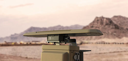
DroneShield Ltd. has released CompassOne, a self-contained navigation solution for fixed site, vehicle and marine applications.
The device provides real-time military-grade location, orientation and direction sensing for deployed static and on-the-go assets. The device can be used both in counter UAS systems and general situations requiring satellite navigation.
With a strong focus on durability and ruggedness, CompassOne is suitable for installation and operation in harsh environments. Military-grade (MIL-SPEC) connectors and high-end stainless-steel hardware ensure uninterrupted connection and protection from the elements, while the aluminium underside provides exceptional impact resistance and rigidity while keeping overall weight low.
CompassOne can operate stand alone or integrate with DroneShield’s DroneSentry system. Power over Ethernet reduces cable clutter and VESA compatibility makes CompassOne easy to integrate into new or existing systems. Installation is clear and fast with status LEDs, installation graphics and tool-less fasteners.
“CompassOne, with its ruggedness and incorporation of advanced technologies, integrates seamlessly within DroneShield’s product ecosystem, and equally with third party systems as a stand-alone product,” said Oleg Vornik, DroneShield CEO. “Its accurate navigation is substantially superior to other systems on the market globally.”
The product is expected to be of interest to both counterdrone and other customers requiring a rugged navigation solution.