Category: Defense

  • Orolia adds new GNSS simulator to BroadSim product line

    Orolia adds new GNSS simulator to BroadSim product line

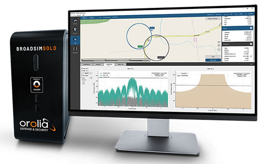
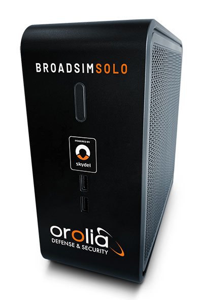
    BroadSim Solo provides advanced GNSS scenario creation on the engineer’s desktop

    Orolia Defense & Security released the latest addition to its GNSS simulator family — BroadSim Solo — at the Institute of Navigation Joint Navigation Conference (JNC) taking place this week in Covington, Kentucky.

    The Solo joins the BroadSim line of Skydel-powered GNSS simulators, which includes models suited for hardware-in-the-loop and multi-element antenna/controlled reception pattern antenna (CRPA) testing.

    Live demonstrations of BroadSim Solo are taking place in the JNC Exhibit Hall at Orolia Defense & Security booth No. 117 through Aug. 26. Orolia provides M-code solutions for resilient positioning, navigation and timing.

    BroadSim Solo shares the same Skydel simulation engine that runs on a standard BroadSim, BroadSim Anechoic and BroadSim Wavefront. It supports advanced scenario creation features and the benefits provided by a software-defined architecture such as high dynamics, a 1000-Hz iteration update rate and ultra-low latency of 5 ms.

    Photo: Orolia
    Photo: Orolia

    Nearly all civilian GNSS signals can be generated through the Solo’s single RF output (one frequency band at a time), along with jamming or spoofing signals, and GPS AES M-code. AES is an encryption method; rather than using the MNSA encryption, it is possible to use AES for testing purposes only.

    BroadSim Solo’s compact form factor is designed to do away with bulk, fitting comfortably at a typical desk or workstation. Plus, the Solo addresses the permanent challenge engineers face with laboratory capacity and availability.

    “Creating complex test scenarios can be a tedious process, especially when emulating challenged environments,” said Tim Erbes, director of engineering for Orolia Defense & Security. “Having the ability to create scripts at your desk significantly frees up lab time and space for running these important simulations. Also, scenario creation is no longer limited to one person fixed to one system. Imagine a team of engineers, each with a BroadSim Solo, simultaneously building tests. Having a whole fleet of BroadSim Solos? It’s game-changing.”

    BroadSim Solo with the Skydel simulation engine offers an intuitive user interface, a comprehensive API supporting Python, C++ and C#, and automation tools and custom plugins that will speed up development cycles, increase performance and ultimately drive innovation.

    “In an effort to enhance the customer experience and expand the reach of advanced GNSS simulators, we wanted to offer an affordable solution with all of the same core features as our most advanced BroadSim systems,” said Tyler Hohman, director of products for Orolia Defense & Security. “This gives our customers the opportunity to place more simulators in the hands of engineers and scientists without sacrificing capabilities. Our hope is that customers will find value in having a simulation ecosystem that is scalable based on their requirements.”

    Photo: Orolia
    Photo: Orolia
  • Spirent Federal launches alternative RF navigation simulator

    Spirent Federal launches alternative RF navigation simulator

    Photo: Spirent
    Photo: Spirent

    Spirent Federal has launched an alternative RF navigation simulator. As GPS jamming and spoofing continue to rise, interest in complementary sources of positioning, navigation and timing (PNT) data has likewise increased.

    Recent government directives recommend a layered, multi-source approach, with much of the attention focused on non-GNSS radio frequency signals. These RF signals, coined alternative RF navigation, offer unique PNT capability in GPS-degraded or denied environments. The signals are secure and resilient and can act as an effective complement to GPS signals.

    Spirent Federal’s product can simulate resilient alternative RF navigation signals on its own or concurrently with GNSS signals. Testing can be static or dynamic, with stationary, pedestrian and ground vehicle trajectories available.

    “As a result of our extensive research and development incorporating a variety of assured PNT technologies, we’re pleased to be the first to provide this capability to our customers,” said Roger Hart, director of engineering. “Our product enables developers to test early and often, from the first stages of R&D to integration and field testing. Solutions can be tested with edge cases, hardened against interference, and deployed faster with greater confidence they will work for our warfighters.”

    Spirent is actively engaged with several alternative RF navigation technologies and technology providers to incorporate signal simulation capability. To learn more, contact Spirent Federal to discuss fielded configurations.

    A U.S. Marine Corps radio operator grounds an during long-range HF radio training in Kuwait Oct. 7, 2020. (Photo: U.S. Marine Corps/Capt. Joshua Hays)
    A U.S. Marine Corps radio operator grounds an during long-range HF radio training in Kuwait Oct. 7, 2020. (Photo: U.S. Marine Corps/Capt. Joshua Hays)

    Collaboration with Xona Space Systems

    Spirent Federal Systems also announced that it is collaborating with Xona Space Systems to develop simulation and test capabilities for Xona signals produced by small satellites (smallsats) operating in low Earth orbit (LEO). Xona is a San Mateo-based startup developing a smallsat constellation for a dedicated PNT service.

    Xona’s patent-pending approach using small satellites in LEO is intended to improve global PNT resilience and accuracy by both enhancing GNSS and operating as an independent system. Xona’s high-power signals utilize advanced signal structure and security techniques, improving jamming and spoofing resistance as well as multipath mitigation.

    “We do all we can to protect, toughen, and augment PNT and are eager to work with emerging companies like Xona who are developing a next-gen navigation and timing architecture,” said Jennifer Smith, senior director of Business Development at Spirent Federal. “Our simulators provide critical support to developers and integrators by enabling testing and validation before the product deploys.”

    The space and defense sectors also benefit from Spirent Federal’s expertise in generating high fidelity RF signals using quadrature (I/Q) data. Spirent test tools allow the full customization of I/Q data. Customers can generate unique I/Q data corresponding to experimental modulation schemes and use Spirent Federal’s signal generation capabilities to create the corresponding RF.  Such rapid prototyping allows for quick turnaround times and shorter iteration cycles.

    Alternatively, scenarios created using Spirent Federal’s proprietary SimGEN software can be saved as I/Q data which can be processed by software-implemented receivers.

    “Building a new generation of satellite navigation and timing services goes far beyond just the satellites,” said Brian Manning, CEO of Xona Space Systems. “It requires building an entire ecosystem from ground stations to chipset manufacturers to end users and systems integrators. Having reliable and trusted simulation capabilities is critical to support all of these areas which is why we are thrilled to be working with Spirent to provide a robust solution to our partners.” 

  • Microchip offers new chip-scale atomic clock for defense

    Microchip offers new chip-scale atomic clock for defense

    New SA65 CSAC provides wider operating temperatures, faster warm-up and improved frequency stability in extreme environments

    Photo:
    Photo: Microchip Technology

    Microchip Technology Inc. is offering the new SA65 chip-scale atomic clock (CSAC), providing precise timing accuracy and stability in extreme environments. Designed for military and industrial systems, the Microchip’s SA65 CSAC features ultra-high precision and low power consumption

    Advanced military platforms, ocean-bottom survey systems and remote-sensing applications all require precise timing. CSACs ensure stable and accurate timing even when GNSS time signals are unavailable, thereby helping industrial and military system designers to meet timing requirements.

    Microchip’s SA65 CSAC is an embedded timing solution with improved environmental ruggedness, delivering higher performance than the previous SA.45s CSAC, including double the frequency stability over a wider temperature range and faster warm-up from cold temperatures. The SA65 has an operating temperature range of –40 to 80 °C and a storage temperature range of –55 to 105 °C. The warm-up time of two minutes at –40 °C is 33% faster than that of the SA.45s.

    These performance improvements benefit designers of highly portable solutions for military applications such as assured positioning, navigation and timing (A-PNT) and C5ISR (command, control, communications, computers, cyber, intelligence, surveillance and reconnaissance). It meets precise frequency requirements of a low size, weight and power (SWaP) atomic clock. Improvements such as fast warm-up to frequency after cold start, temperature stability over a wide operating range, and frequency accuracy and stability enabling extended operation while GNSS is denied help to ensure mission success in conflict environments.

    The SA65 CSAC provides precise timing for portable and battery-powered applications requiring continuous operation and holdover in GNSS-denied environments. The SA65 is form-, fit- and function-compatible with the SA.45s, which minimizes risk and redesign costs for the system developer while improving performance and environmental insensitivity.

  • NextNav demos GPS-free PNT network for critical infrastructure

    NextNav demos GPS-free PNT network for critical infrastructure

    The trial for the U.S. Department of Homeland Security showcases the precise, resilient timing capabilities of NextNav’s TerraPoiNT service in the event GPS is unavailable.

    NextNav has successfully demonstrated the timing precision and resilience of its terrestrial positioning, navigation and timing (PNT) system, TerraPoiNT, in a recent evaluation by the Science and Technology Directorate of the Department of Homeland Security (DHS S&T).

    The trial tested the timing redundancy of the TerraPoiNT system in a number of scenarios, including instances of GPS outages, spoofing and jamming. It validates TerraPoiNT’s capabilities as a terrestrial, GPS-free network capable of powering critical national infrastructure in the event of GPS failure.

    During a simulated 72-hour GPS outage, the TerraPoiNT service was able to deliver a timing accuracy better than 50 nanosecond in urban and semi-urban environments, successfully meeting timing requirements for various applications including 5G networks, the synchronization of the power grid, and more.

    In addition, TerraPoiNT provided precise timing and redundancy utilizing two alternate absolute timing sources — atomic clock (Cesium/Rb) and LEO satellite (Satelles).

    “GPS is critical infrastructure, but it has its limitations,” said Ganesh Pattabiraman, co-founder and CEO of NextNav. “In working with DHS S&T, we’ve validated that TerraPoiNT can serve as an important backup to GPS and ensure the resilience and continuity of our nation’s most critical systems, including next-generation telecommunications networks, financial services, and power grids.”

    Satelles STL

    STL from Satelles was one of two alternate absolute timing sources for the trial. Available today on a global basis, STL is a service that provides alternative PNT independent of GPS, supporting PNT-reliant applications such as 5G communications networks, high-frequency trading in financial markets, and electrical grids throughout the United States and around the world.

    “Satelles applauds NextNav for conducting a successful field demonstration of its resilient PNT service, and we were delighted to have played an instrumental part in the exhibition,” said Christina Riley, vice president of Commercial PNT.

    NextNav’s selection of STL to help demonstrate their own technology’s operation in the absence of GPS was a natural fit. That’s because earlier this year the U.S. National Institute of Standards and Technology (NIST) confirmed STL as an accurate and reliable source for the wide-area delivery of Coordinated Universal Time independent of GPS/GNSS.

    Previous TerraPoiNT evaluations

    The successful trial builds on recent evaluations of TerraPoiNT conducted by independent bodies. Earlier this year, the Department of Transportation (DOT) evaluated 11 alternate PNT solutions, in which each was rigorously tested across applications and scenarios. As a result of the evaluation, the DOT named TerraPoiNT the best and only performing solution across all PNT categories.

    Spartacus. In June, NextNav entered into a definitive merger agreement with Spartacus Acquisition Corporation in a transaction that would result in NextNav being listed on the Nasdaq. The transaction is expected to close late in the third quarter of 2021 or early in the fourth quarter of 2021, subject to satisfaction of customary closing conditions.

    Image: kanawatvector/iStock/Getty Images Plus/Getty Images
    Image: kanawatvector/iStock/Getty Images Plus/Getty Images
  • US Defense Department looking for GNSS disruption detection and analysis

    US Defense Department looking for GNSS disruption detection and analysis

    The U.S. Department of Defense wants help making sense of commercially and publicly available information that could be used to detect GNSS disruptors, especially over large areas.

    Obtaining the ability to detect and geolocate GNSS disruptions has been cited as an unmet need in a number of U.S. national policies and plans dealing with positioning, navigation and timing.

    The recently posted solicitation calls the project “HARMONIOUS ROOK – Situational Awareness for Intentional Disruption of Global Navigation Satellite System (GNSS) Users.” The solicitation says:

    “The Department of Defense (DoD) seeks commercial solutions leveraging machine-driven analytics and datasets derived from publicly/commercially available information (PAI/CAI) to provide a situational awareness capability for intentional global navigation satellite system (GNSS) disruptions. This solicitation is particularly focused on persistent, large-area coverage of falsified GNSS emitters that result in localized spoofing phenomenology.”

    Studies and analyses by non-profit organizations and commercial entities have demonstrated the ability of non-governmental organizations to do this kind of work and produce remarkable results. In 2017, our Resilient Navigation and Timing Foundation detected and reported on widespread GPS spoofing in the Black Sea.

    Another non-profit, C4ADS, built upon our work and produced a detailed 2019 report on GPS spoofing in Russia and Syria. In 2019 and 2020, the environmentally oriented non-profit SkyTruth reported on circle spoofing in China and around the globe. In July, SkyTruth revealed warship activities being misreported in Automatic Identification System databases.

    This acquisition is being led by the Defense Innovation Unit, or DIU. The unit was specifically created to accelerate the adoption of commercial technology and services by the defense and national security establishments. While letting a traditional DoD contract for a prototype can often take up to 18 months, DIU aims to award contracts within 60 to 90 days of identifying the problem.

    To do this, DIU uses the government’s “commercial solutions opening” process, which is designed to be simple and quick.

    Companies who provide analytic services and those who have unique data sets are both encouraged to apply. The deadline is August 23.


    Dana A. Goward is president of the Resilient Navigation and Timing Foundation

    An Interim Armored Vehicle "Stryker" and AH-64 Apache helicopters with Battle Group Poland move to secure an area during a lethality demonstration as part of Saber Strike 18 in June 2018. (Photo: U.S. Army/Spc. Hubert D. Delany III, 22nd Mobile Public Affairs Detachment)
    An Interim Armored Vehicle “Stryker” and AH-64 Apache helicopters with Battle Group Poland move to secure an area during a lethality demonstration as part of Saber Strike 18 in June 2018. (Photo: U.S. Army/Spc. Hubert D. Delany III, 22nd Mobile Public Affairs Detachment)
  • Defense Innovation Unit seeks GNSS interference solutions

    Defense Innovation Unit seeks GNSS interference solutions

    A surveillance system is demonstrated during a Naval Information Warfare Systems Command (NAVWAR). (Photo: Rick Naystatt/U.S. Navy)
    A surveillance system is demonstrated during a Naval Information Warfare Systems Command (NAVWAR) exercise. (Photo: Rick Naystatt/U.S. Navy)

    The U.S. Defense Innovation Unit (DIU) is asking for commercial solutions to fight GNSS disruptions, including jamming and spoofing.

    DIU is particularly asking for “solutions leveraging machine-driven analytics and datasets derived from publicly/commercially available information to provide a situational awareness capability” against intentional disruptions.

    Responses to “HARMONIOUS ROOK — Situational Awareness for Intentional Disruption of Global Navigation Satellite System (GNSS) Users” are due by Aug. 22.

    DIU is a Department of Defense organization focused exclusively on fielding and scaling commercial technology across the U.S. military to help solve critical problems.

    The solicitation is focused on “persistent, large-area coverage of falsified GNSS emitters that result in localized spoofing phenomenology.”

    It cites intentional manipulation of GNSS signals as enabling “nefarious activities, to include narcotics trafficking, unapproved operation of autonomous vehicles, illegal fishing and sea-borne piracy.”

    “Additionally, nation-state use of GNSS jamming or spoofing systems may extend beyond the area of conflict, causing deleterious effects on civilian populations,” the solicitation states. “Such activities degrade or deny critical geolocation capabilities and further introduce hazards to safety-of-life-navigation, critical infrastructure, and emergency response services. “

  • Masten to develop beacon navigation system for the Moon

    Masten to develop beacon navigation system for the Moon

    PNT beacons can be deployed in orbit to penetrate the lunar surface and enable consistent wireless connectivity. (Image: Masten Space Systems)
    PNT beacons can be deployed in orbit to penetrate the lunar surface and enable consistent wireless connectivity. (Image: Masten Space Systems)

    Masten Space Systems has been awarded a U.S. Air Force contract to develop and demonstrate a lunar positioning and navigation network prototype that functions much like GPS.

    The Phase II Small Business Innovation Research (SBIR) contract was awarded through the Air Force Research Laboratory’s AFWERX program. AFWERX connects innovators across government, industry and academia.

    The navigation network will enhance cislunar security and awareness by enabling navigation and location tracking for spacecraft, assets, objects and astronauts on the lunar surface or in lunar orbit. As the lunar infrastructure grows, the network will help advance lunar science and resource use by improving landing accuracy and hazard avoidance near critical lunar sites.

    “Unlike Earth, the Moon isn’t equipped with GPS so lunar spacecraft and orbital assets are essentially operating in the dark,” said Matthew Kuhns, vice president of research and development at Masten. “As a result, each spacecraft is required to carry heavy navigation hardware and sensors on-board to estimate positioning and detect potential hazards. By establishing a shared navigation network on the Moon, we can lower spacecraft costs by millions of dollars, increase payload capacity, and improve landing accuracy near the most resource-rich sites on the Moon.”

    In Phase I, Masten completed the concept design for the network prototype that offloads positioning, navigation, and timing (PNT) beacons from a spacecraft into a dedicated sensor array on the Moon.

    In Phase II of the project, scheduled to be complete in 2023, Masten will develop PNT beacons equipped to survive harsh lunar conditions. Masten is collaborating with Leidos to build shock-proof beacon enclosures that can be deployed in lunar orbit to penetrate the lunar surface and create an autonomous surface-based network. Similar to a mesh network, the surface-based network can enable consistent wireless connectivity to lunar spacecraft, objects, and orbital assets.

    “Leidos is proud to collaborate with Masten Space Systems in their quest toward a successful lunar surface-based positioning and navigation network,” said Thomas Sereno, vice president and division manager of the Applied Science operation at Leidos. “We are prepared to support the team as they progress through the next phase of the contract.”

    In Phase II of the project, the PNT technology will also be tested aboard Masten’s rocket-powered lander, Xodiac, to demonstrate payload integration and beacon operations in a terrestrial environment, enabling a path towards lunar demonstration.

    Masten has more than a decade of experience maturing PNT systems, including Jet Propulsion Laboratory’s lander vision system that was tested on Masten’s Xombie rocket to enable a successful Mars mission for the NASA Perseverance rover.

    “As one of the first commercial companies sending a lunar lander to the Moon, we’re in a unique position to develop and deploy a shared navigation system that can support other government and commercial missions and enable a thriving lunar ecosystem,” said Masten CEO Sean Mahoney. “We are literally blazing the trail with this effort, creating the pathway for regular, ongoing and reliable access to the Moon.”

  • US Space Force to host GPS document forum

    US Space Force to host GPS document forum

    CGSIC logo

    The U.S. Space Force will host the 2021 Public Interface Control Working Group and Open Forum in September and November. The meetings are open to the public in person and virtually on Wednesday, Sept. 29, 8:30 a.m. to 4 p.m., and Tuesday, Nov. 19, 8 a.m. to 4 p.m. (Pacific Time).

    The meeting and forums will discuss the following documents:

    The purpose of the meeting is to update the public on GPS public document revisions and collect issues and comments for analysis and possible integration into future GPS public document revisions.

    The meeting will be held in person at

    Los Angeles Air Force Base
    Great Room, -PCT Campus
    100 Sepulveda, Blvd.
    El Segundo, CA 90245

    Attendees are highly encouraged to participate virtually. It can be accessed at this link or at this link.

    • Primary Dial In: 571-200-1700, Meeting ID: 160 913 1495, Password: 813441
    • Backup Dial In: 410-874-6300, Conference PIN: 961616381

    The official public notice in the Federal Register provides further information, including how to register, submit comments and dial in on the telephone.

  • DroneShield counter-UAS products head to Australia, Brazil

    DroneShield counter-UAS products head to Australia, Brazil

    Counter-unmanned aircraft system (C-UAS) company DroneShield has sold its RfOne MKII long-range sensors to the Australian Army. The capability is being delivered immediately to allow the Australian Army to assess its future counter-drone requirements and options, the company said.

    “As an Australian company, DroneShield is immensely proud to support the Australian Army with its long-range counter-drone strategy, said DroneShield CEO Oleg Vornik.

    Deployment of the long-range sensors will highlight the flexibility, resilience and capabilities of DroneShield equipment in a dynamic field environment, while also assisting the Australian Army in establishing its counter-drone requirements and future capability options.

    The sale, announced July 19, was structured as a one-off sale to the Australian Army. Similar to the standard purchases from DroneShield’s other defence and law enforcement customers, comprises a small purchase of equipment.

    Australian counter-unmanned aircraft system (C-UAS) company DroneShield has sold several of its RfOne MKII long-range direction-finding sensors to the Australian Army. The deal, announced July 19. and will “allow the Australian Army to assess its future counter-[UAS] requirements and options”, DroneShield said in a statement, as well as equipping existing platforms with the sensors.

    Brazilian Sale

    DroneShield also has received formal approval from Anatel, the Brazilian National Telecommunications Agency responsible for issuing the concession of new radio frequencies. Following approval earlier this month, the company has sold a quantity of its DroneGun Tactical units to the Brazilian government.

    “Brazil is a large and sophisticated market for military and security equipment, and we are pleased to commence active presence in the country, deploying equipment to the customers,” Vornik said. “We look forward growing our presence in Brazil with the urgent counter-drone requirements mirroring what we are seeing in other countries.”

    New Kit

    Immediate Response Kit. (Photo: DroneShield)
    Immediate Response Kit. (Photo: DroneShield)

    DroneShield also released its Immediate Response Kit (IRK), a rapidly deployable C-UAS detection and defeat kit. The IRK consists of an RfPatrol portable (1.2 kg/2.6 lbs incl battery) detection device and a DroneGun MKIII (2.1 kg/4.7 lbs including battery) defeat device in a rugged carry case.

    Both RfPatrol and DroneGun MKIII are currently fielded by military and government customers globally.

  • NTS-3 mission progresses toward launch in 2023

    NTS-3 mission progresses toward launch in 2023

    The Navigation Technology Satellite-3 (NTS-3) program is making major strides in developing a new navigation spacecraft for in-space demonstration. The NTS-3 is scheduled to launch to geosynchronous orbit from Cape Canaveral in 2023.

    This summer, Northrop Grumman Corp. delivered the ESPAStar-D spacecraft bus to L3Harris Technologies of Palm Bay, Florida.

    “The transfer of the bus allows L3Harris to move forward building the NTS-3 spacecraft,” said 2nd Lt. Charles Schramka, the program’s deputy principal investigator. “L3Harris will perform tests and begin integrating the NTS-3 PNT payload onto the bus. Together the bus and payload will form the NTS-3 spacecraft.”

    Following L3Harris’s work, the Air Force Research Laboratory (AFRL) will test the bus with the NTS-3 ground control and user equipment segments, and will perform its own integrated testing on the overall NTS-3 system architecture.

    Northrop Grumman has successfully delivered an ESPAStar-D spacecraft bus to L3Harris in support of the NTS-3 mission. (Photo: U.S. Air Force)
    Northrop Grumman has successfully delivered an ESPAStar-D spacecraft bus to L3Harris in support of the NTS-3 mission. (Photo: U.S. Air Force)

    NTS-3 in the Vanguard. In 2019, the U.S. Air Force designated NTS-3 as one of three Vanguard programs — priority initiatives to deliver new capabilities for national defense. The NTS-3 mission is to advance technologies to responsively mitigate interference to position, navigation and timing (PNT) capabilities, and increase system resiliency for GPS military, civil and commercial users.

    “This is the first time an ESPAStar bus has been built and delivered as a commercially available commodity,” said Arlen Biersgreen, NTS-3 program manager. “NTS-3 is using a unique acquisition model for the ESPAStar line that fully exercises the commercial nature of Northrop Grumman’s product line, in order to provide the bus to another defense contractor for payload integration using standard interfaces.”

    The ESPAStar-D bus, built in Northrop Grumman’s satellite manufacturing facility in Gilbert, Arizona, includes critical subsystems such as communications, power, attitude determination and control, in addition to configurable structures to mount payloads.

    The bus will “provide affordable, rapid access to space,” according to Northrop Grumman. Its configuration, using an Evolved Expendable Launch Vehicle (EELV) Secondary Payload Adapter (ESPA), allows multiple separate experimental payloads to be stacked together on one launch vehicle. AFRL developed the ESPA ring to transport space experiments, allowing for lower cost and more frequent trips to space for government and industry users.

    Besides the bus delivery, there are other advances in the program.

    GNSSTA receiver. In June, AFRL took delivery of an experimental receiver — GNSS Test Architecture (GNSSTA). The receiver was developed by the AFRL unit the Sensors Directorate, located at Wright-Patterson Air Force Base in Ohio, and Mitre Corporation. GNSSTA is a reprogrammable software-defined signal receiver that will allow the Air Force to receive both legacy GPS and advanced signals generated by NTS-3.

    AFRL will continue its integration efforts through 2022 to ensure all parts are working together for the fall of 2023 NTS-3 launch.

    “With the delivery of the bus we are entering into the next phase of payload integration,” Biersgreen said. “These recent breakthroughs allow the program to continue to move forward and prepare for launch of the first U.S. integrated satellite navigation experiment in over 45 years.”

    Artist’s concept for NTS-3 in geostationary orbit. (Artist's concept: 2d Lt Jacob Lutz, AFRL/RV)
    Artist’s concept for NTS-3 in geostationary orbit. (Artist’s concept: 2d Lt. Jacob Lutz, AFRL)
  • SMC commander Lt. Gen. Thompson retires

    SMC commander Lt. Gen. Thompson retires

    Lt. Gen. John F. Thompson
    Lt. Gen. John F. Thompson

    Lt. Gen. John F. Thompson, commander of the Space and Missile Systems Center (SMC), will retire Aug. 1. A ceremony celebrating his career and achievements took place July 27 at Los Angeles Air Force Base, California, where SMC is based.

    Thompson, who is the longest serving three-star commander for SMC, retires after a 36-year career with the U.S. Air Force, having served in various roles leading defense acquisition programs, strategic systems and lifecycle management.

    Brig. Gen. D. Jason Cothern, current vice commander of SMC, will serve as the SMC commander while the center awaits a confirmation of a three-star general officer.

    SMC includes the positioning, navigation and timing (PNT) mission, in which professionals acquire, deliver and sustain reliable GPS capabilities to America’s warfighters, allies and civil users.

    “Lt. Gen. Thompson’s exemplary career has made the nation safer, stronger and better secured against an increasingly contested space environment, and earned the well-deserved opportunity to enjoy this next chapter in his life,” stated a press release from SMC.

    As the commander of SMC, he led more than 6,300 military, government service and contract employees nationwide, and oversaw an annual budget of $9 billion, which accounts for 85 percent of the nation’s space budget.

    In the past 18 months, Lt. Gen. Thompson tirelessly led the groundwork for the stand-up of the U.S. Space Force’s newest Field Command, Space Systems Command, which will lead the Force in the development, delivery and acquisition of innovative space warfighting capabilities.

    Having completed his four-year tour as the SMC commander, his retirement will not affect the timeline of the SSC stand-up — a complex process requiring activities and approvals at the highest levels before implementation.

  • U.S. Army Sentinel A4 radar program receives Orolia M-code solution

    U.S. Army Sentinel A4 radar program receives Orolia M-code solution

    Orolia Defense & Security delivers M-code-enabled timing and synchronization to Lockheed Martin

    In September 2019, Lockheed Martin was awarded a contract to develop the U.S. Army’s Sentinel A4 radar system, an air and missile defense radar that will provide improved capability against dynamic threats.

    The following November, Orolia Defense & Security announced the availability of M-code military GPS receivers in its flagship SecureSync — the first time server approved by the Defense Information Systems Agency.

    Orolia is supplying SecureSync units for Lockheed Martin's Sentinel A4 radar. (Photo U.S. Army)
    Orolia is supplying SecureSync units for Lockheed Martin’s Sentinel A4 radar. (Photo U.S. Army)

    This May, Orolia delivered a shipment of M-code-enabled SecureSync mission timing and synchronization units to Lockheed Martin, marking a key milestone for the Army program. SecureSync with M-code provides enhanced resilient positioning, navigation and timing (PNT) capabilities and improved resistance to existing and emerging GPS threats, such as jamming and spoofing.

    Lockheed Martin selected Orolia’s SecureSync M-code as the A4 system’s resilient time and frequency reference solution in part due to its modular, open architecture – the same characteristics that are the cornerstone of the radar’s design – making integration a simple process and ensuring future upgrades.

    “As a trusted Lockheed Martin partner, Orolia is proud to support the development of the Sentinel A4, which will be a key asset to our warfighters for decades to come,” said Hironori Sasaki, president of Orolia Defense & Security. “Making M-code available now in a readily configurable and scalable form factor is a critical step in advancing our forces out in the field, whether in the air or on the ground,” Sasaki added.

    The next-generation of U.S. military systems are fortified with M-code, and Orolia leads the industry in M-code solutions for navigation warfare (NAVWAR) environments.

    Orolia is supplying SecureSync units for Lockheed Martin's Sentinel A4 radar. (Photo U.S. Army)
    Orolia is supplying SecureSync units for Lockheed Martin’s Sentinel A4 radar. (Photo U.S. Army)
    Photo:
    Image: Orolia