Fugro has launched the G4 service, designed to provide GNSS augmentation for offshore positioning applications. The new satellite correction service takes advantage of all four GNSS: GPS, GLONASS, BeiDou and Galileo.
By using all available GNSS satellites, Fugro’s G4 service is designed to improve availability and reliability of offshore positioning and thus enhance the safety and productivity of a wide range of survey and other activities offshore. G4 represents a significant advancement compared to augmentation systems which are based on GPS-only or GPS + GLONASS, the company said.
The BeiDou system operated by China currently provides coverage in the Asia-Pacific region. Fugro’s G4 service already utilises the first BeiDou satellites and is ready to start using the Galileo satellites as soon the EU announces Initial Operational Capability (IOC) status for this system. Galileo and future BeiDou satellites will be automatically included as they come online, steadily increasing availability and robustness of the integrated augmentation service.
The new G4 service will be particularly beneficial when the line-of-sight to certain satellites is obstructed by offshore structures – a key consideration during critical positioning operations. The G4 augmentation signals, transmitted via seven high–powered communication satellites to provide at least two independent broadcast channels anywhere in the world, will offer Fugro’s customers unrivalled coverage and availability.
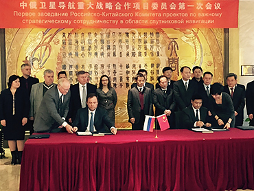
Russia and China have signed a cooperation agreement on satellite navigation, a Russian Space Agency spokesperson told RIA Novosti on Tuesday.
Roscosmos chief Igor Komarov met with Xu Dazhe, the leader of China’s National Space Administration, on an official visit in Beijing.
“The first provision to set up a committee and a protocol were signed during the first working session. Igor Komarov and Xu Dazhe discussed issues of bilateral cooperation in the field of electronic components for rocket construction and building rocket engines,” the spokesperson said.
A Russian-Chinese committee on satellite navigation was established in October 2014 at the meeting between Russia’s Deputy Prime Minister Dmitry Rogozin and his Chinese counterpart, Wang Yang.
In November, China North Industries Corporation (NORINCO) and the Russian GLONASS nonprofit partnership agreed to establish a joint venture to promote worldwide services based on GLONASS and BeiDou.
Russia and China also recently completed joint reconnaissance for the placement of GLONASS differential correction and monitoring stations in the Chinese cities of Urumqi and Changchun. Each country is expected to accommodate three such facilities.
A senior Chinese government space official on Feb. 5 said precision-navigation user receivers in China will be fitted with chipsets receiving satellite signals from BeiDou, GPS, GLONASS, and Galileo, according to Space News. The move could accelerate the trend among navigation chipset and receiver makers to build gear for multi-constellation reception, and at the same time undermine regional measures to promote one system over others.
Chen Zhi, deputy chief designer of the China Aerospace Science and Industry Corp., said China’s early deployment of satellite navigation receivers for precision agriculture already feature multi-constellation GPS-Beidou receivers.
The United States and European Union have signed World Trade Organization agreements for their constellations, GPS and Galileo. China and Russia are not part of the agreements.
BeiDou Signals, Future Receiver Design Highlighted at Stanford PNT Symposium
By James D. Litton and Tom Langenstein
James L. Litton
The Stanford Center for Position, Navigation and Time conducted its eighth symposium on PNT in October 2014. These symposia have always been a superb two (this year three) days of excellent presentations, ranging over the entire domain of PNT, including policy factors as well as technical ones.
This year the first day featured student speakers, either from Stanford or the students of former Stanford students who are now faculty at other universities. The conference is by invitation only; sponsors include Lockheed Martin, Boeing, and other companies involved with GNSS. This essay highlights two presentations that struck us as harbingers of change in the industry: Greg Turetzky’s paper on ubiquitous location, and Minquan Lu’s and Zheng Yao’s paper on new signal structures for BeiDou.
Brad Parkinson gave a keynote address mixing challenges and opportunities from the frontiers of policy formation. David Last did not fail to amuse with his lighthearted and satirical commentary on navigation and society at dinner. Many others gave noteworthy presentations, and all of the presentation slides can be found online.
Tom Langenstein
Both papers that we selected for this article have very broad scope with considerable strategic significance in GNSS design and applications. It seems a little impertinent, as well as superficial, to try to convey their essence in fewer than 2,000 words, but the material presented is available elsewhere, too.
New Signal Structures for BeiDou
Professors Mingquan Lu and Zheng Yao of Tsinghua University laid out in clear and detailed fashion the motivations for BeiDou’s choosing to introduce new signals for the Phase III global system, analyses of alternative modulations, and the results of bench testing in service to the desired properties (interoperability, acquisition and tracking thresholds, receiver complexity, in-band interference, and so on).
They emphasized one non-technical or operational motivation: independent proprietary designs for patent protection. No declaration of policy intention was made; however, the direction was clear, even though the authors are university professors and not government officials.
Some of this work has been published elsewhere in IEEETransactions by the same authors and has a substantial history, reflecting the lessons learned from the predecessor system designs and very thorough analysis, simulation and bench testing. Space does not allow extensive citation, but the key drivers for the designs and the results are summarized below. The preferred modulations chosen or synthesized are quadrature multiplexed binary offset carrier (QMBOC) for B1C and asymmetric constant envelope-binary offset carrier (ACE-BOC).
The principal deficiencies cited of the earlier-proposed BeiDou Phase III signals (circa 2010-ICG) were given as:
no independent intellectual property rights; thus, a big patent risk
signal performance needs to be improved
more flexible receiving modes and more varied application scenarios should be considered.
The principal requirements for BeiDou Open Service signals were cited as:
independent intellectual property rights
better compatibility and interoperability with GPS and Galileo
smooth transition from Phase II to Phase III
improved performance
Separate requirements were stated for the B1C and B2 signals, as follows:
B1C: (QMBOC)
compatibility with other signals of the same carrier frequency
better interoperability with GPS L1 and Galileo E1 signals
better ranging accuracy (than GPS C/A and BeiDou Phase II B1(I))
receiving mode diversity for different receivers (low-end and high-end)
independent Intellectual property rights
B2C: (ACE-BOC)
multiplexed B2a and B2b into a constant envelope signal
better interoperability with the GPS L5 and GALILEO E5 signals
In the quoted case study tests, simulated ACE-BOC and AltBOC signals were generated at several fixed transmitting power levels and processed using software receivers. For each given transmit power level, the ACE-BOC was allotted three times power for the pilot channel over that of the data channel while the AltBOC allocated equal amount of power for both the pilot and the data channel, that is, 3:1 for ACE-BOC and 1:1 for AltBOC.
The resulting tracking performance of the ACE-BOC is more robust than that of the AltBOC.
Table 1, taken from the presentation, provides an overview of the signals.
Table 1. New signal structures proposed for BeiDou.
The compatibility properties of the new signals, if adopted, which seems quite likely, are desirable. The implicit intellectual property aspects of the development, both in motivation and in differential design of a signal structure which seems to be claimed as novel have a defensive basis, apparently, in earlier assertions of proprietary designs. It will be interesting to see whether similar international negotiations follow, or perhaps already have. The paper was well received and stimulated considerable hallway comment.
Ubiquitous Location
Turetzky’s paper laid out the phenomenal growth of location-based services and the implications of such growth for design requirements in GNSS-wireless at the user device level and at the silicon level. On growth (from various quoted sources):
The compound annual growth rate of GNSS devices will continue, from its current 22 percent level to a robust 9 percent for the years 2016-2022; heading for seven billion installed units by 2022.
The cumulative core revenue in the decade 2012-2022 will be 46 percent in LBS portable and wearable devices and 47+ percent in vehicles.
There will be many billions of installations of indoor location technologies by 2018, in virtually every venue imaginable.
Some of the design implications of the requirements driving the growth in indoor location are:
Always Located, or continuous location. For this case, the energy dissipated per day (16 hours) and signal availability (100 percent) are the featured specification and the secondary specification, respectively. These specifications, in turn, require hybrid constellations and minimal standby power consumption.
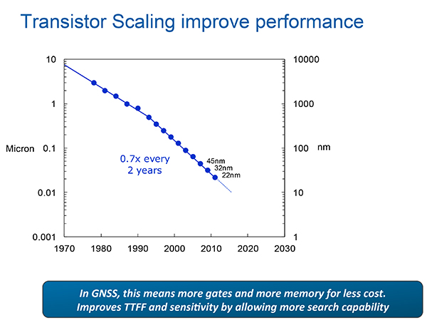
The scaling down to very small (14 nanometer) dimensions enables much faster switching speeds, search rates and lower power dissipation in active modes and more complex algorithms, but at the expense of leakage current, which adversely affects standby power, an increasingly important factor.
Thus, for GNSS design, the challenges are to:
Take advantage of benefits of smaller geometries to achieve higher clock speeds, more memory, lower active power and smaller size, while greatly reducing standby power from leakage;
Incorporate new methodologies at chip and system design level; Integrate multiple radios on a single die to reduce cost and size without creating interference to a very sensitive GNSS radio;
Integrate multiple radio sources into a single location solution;
Bring together a disparate value chain;
Turetzky outlined a vision for his employer, Intel, to be a leader in all aspects of these revolutionary developments. The technology roadmaps embrace most modalities of positioning: GNSS, Bluetooth, WI-Fi, cellular, and SBAS, and cross most platforms, including wearables. We think that another, unemphasized challenge is in the increasing density of these units with the current specifications on out-of-band-emissions and the spectrum sharing and spectrum management factors in the ubiquity of the devices.
From Greg Turetzky’s Ubiquitous Location paper, presented at Stanford PNT Symposium.
Tune in to our free webinar Receiver Design for the Future,with Greg Turetzky of Stanford speaking on Ubiquitous Location, scheduled for Jan. 15 (1 p.m. EST/ 10 a.m. PST/ 6 p.m. GMT). Register today!
Both papers represented the dynamism of our industry and its diversity of technologies and practitioners and the service to that industry provided by the remarkably consistent excellence of this symposium.
James D. Litton heads the Litton Consulting Group and previously played key executive roles at NavCom Technology and Magnavox.
Tom Langenstein is executive director of the Stanford Center for Position, Navigation, and Time, and deputy program manager of the Gravity Probe-B project.
By Li Wang, Director of the International Cooperation Center, China Satellite Navigation Office
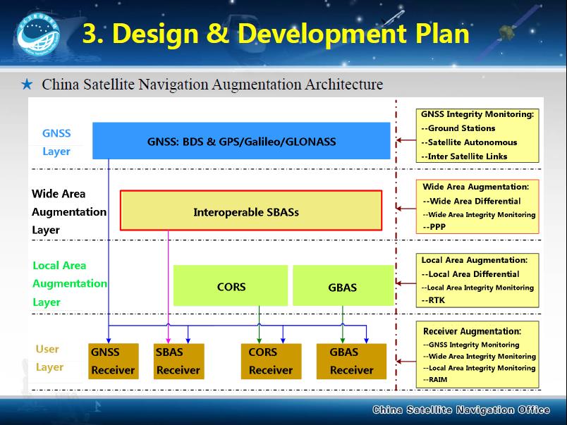
By adhering to the principles of independence, openness, compatibility, and gradualness, China is steadily accelerating the construction and development of the BeiDou Navigation Satellite System.
The BeiDou System already provides continuous and reliable Full Operational Services to most parts of the Asia-Pacific region. Its positioning, navigation, and timing performance keeps improving, while the deployment for a global constellation is also making progress. The BeiDou System and its products, which are compatible with other navigation satellite systems, have been gradually applied in many sectors and industries related to the national economy and to entering the mass market.
As one of the four core GNSS service providers, BeiDou has always made unswerving efforts to exchange, coordinate, and cooperate with other organizations, system providers, and users.
BeiDou has been actively engaged in international affairs on the platform of the United Nations, such as participation in related activities held by the International Committee on Global Navigation Satellite Systems (ICG), and coordinated affairs under the framework of the International Telecommunication Union (ITU). It has also pushed forward the integrated applications of BeiDou and other navigation satellite systems in the fields of civil aviation, maritime traffic, mobile communication, and so on.
In order to provide better services for global users, the BeiDou system has carried out exchanges and coordination with the other navigation satellite systems. It has established cooperative mechanisms with GPS and GLONASS, and respectively signed the Joint Statement of U.S.-China Civil Global Navigation Satellite Systems (GNSS) Cooperation, as well as the Memorandum of Understanding between China and Russia on Cooperation in the Field of Satellite Navigation. Furthermore, the cooperation between the BeiDou and Galileo systems has also been included into the China-EU 2020 Strategic Agenda for Cooperation.
Potential areas for cooperation may include compatibility and interoperability, GNSS applications, policies and standards, international GNSS service performance monitoring and assessment, and so on.
Meanwhile, the BeiDou System continues carrying out the BeiDou/GNSS Application Demonstration & Experience Campaign (BADEC) and has negotiated with related countries to jointly establish BeiDou/GNSS Centers. Those centers will implement BeiDou/GNSS popularization, exhibition, application demonstration, and user experience activities, as well as system performance testing and assessment, academic exchanges, training, and R&D, to jointly promote the compatibility and interoperability among the multiple navigation satellite systems, boost the spread of technologies, and improve satellite navigation applications and industrial development..
In 2015, China will continue this effort, launching four to five next-generation BeiDou Navigation Satellites (MEO and IGSO) for testing and verification of new technologies.The BeiDou System with global coverage will completely be established by around 2020. This will enable provision of continuous, stable, and reliable satellite navigation services for global users.
Global navigation satellite systems and related industries are going through an unprecedented revolution. Under such an environment, compatibility and interoperability among systems, and integration of multiple industries, will be the tendencies of future, which will definitely promote wide applications of GNSS in broadening fields. During such a process, the BeiDou System with distinctive characteristics will abide by the objective of “serve the world and benefit mankind,” undertaking the responsibility and obligation to work together with other systems to provide better services for global users.
Li Wang is the director of the International Cooperation Center, China Satellite Navigation Office.
China North Industries Corporation (NORINCO) and the Russian GLONASS nonprofit partnership agreed to establish a joint venture to promote worldwide services based on GLONASS and BeiDou, according to a report in the Russian daily newspaper izvestia.
The two parties met November 11 in the Chinese city of Zhuhai. Under the agreement, the parties will identify existing technological competence that will be the foundation for the joint venture, and seek government support for joint initiatives to promote abroad.
Before the establishment of the joint venture, the parties agreed to establish a Russian-Chinese center for the implementation of satellite navigation technologies in the civil sphere. According to the agreement, “The center will be the controlling authority in determining the future direction of the joint venture and will deal with administrative issues related to the establishment of the future joint venture.”
Another topic at the meeting was the feasibility of establishing an international techno park dedicated navigation topics using GLONASS and BeiDou. China already has two specialized industrial park focused on developing technologies based on BeiDou.
NORINCOis a Chinese company that manufactures vehicles, machinery, optical-electronic products, oil-field equipment, chemicals, light industrial products, explosives and blast materials, and civil and military firearms and ammunition. NORINCO is also involved in domestic civil construction projects.
China plans to build a BeiDou station in Antarctica this summer, according to a report in the Sydney Morning Herald. China’s official Xinhua news agency disclosed the plans.
The facility at Great Wall station in Antarctica will include receivers, auxiliary equipment and a reference station key to improving BieDou’s accuracy, according to the Chinese enews.com website.
Project leader Wu Xuefeng said the BeiDou facility would greatly improve China’s Antarctic mapping autonomy and improving the system’s precision.
The BeiDou facility will join others, including Norway’s Trollsat, strategically located in Antarctica to fit that country’s global networks, but which some claim breach the Antarctic Treaty. The treaty says “Antarctica shall be used for peaceful purposes only” and prohibits activities of a military nature.
Norwegian Bard Wormdal, author of The Satellite War, told Fairfax Media, “The Chinese military wants to use BeiDou for instance for guiding all sorts of missiles. A BeiDou base in Antarctica makes the system more reliable and precise.” He first raised alarm over the Norwegian satellite base at its Troll Antarctic station, which he found had been used by the U.S. National Geospatial Intelligence Agency.
Russia has three GLONASS ground stations on the continent.
Hyman Huang of South Surveying & Mapping Instrument Co. talks with GPS World about the company’s new dual-frequency GNSS Receiver and its tablet counterpart while at InterGeo 2014, held October 7-9 in Berlin.
After the death of Mao Zedong, who had himself changed the “cultural” face of China, Deng Xiaoping led China from 1978 until his death in February 1997. During that period, China advanced economically further than it did in the previous 200 years, and rose from a financial backwater into one of the world’s largest economies. From 1978 to 1998, GNP increased 500%, average annual income rose from a few hundred dollars to $1,800, savings increased 14,000%, and exports went from $10 billion a year to $153 billion. In a Chinese 1998 survey, Deng was named the number-one hero in China.
Deng Xiaoping.
To achieve all this, there had to be a strategy — a vision of how to bring about such significant change. The approach chosen was to lead and support through government-sponsored initiatives — and the group who was in the best position to be able to convince people and demonstrate by example was China’s well-educated military.
So now we get to GNSS, and of course one of these initiatives was to emulate what the U.S. had done and to create its own satnav system. So we have the BeiDou/Compass space and ground control infrastructure. And having built all this, indeed they did come and a Chinese GNSS industry began to emerge. But it nearly didn’t happen.
In 1994 as part of Deng Xiaoping’s efforts, a state company was formed to pursue economic reform. Ruxin Zhou was one of those military guys who was there, and he recognized that the planned military BeiDou satnav system could be an avenue towards a huge commercial opportunity for China. But the Chinese military was already launched on a course to build BeiDou for their own purposes, and maybe they didn’t want to get caught up in these economic changes going on with the civilian population. As a member of the government advisory group, Colonel Zhou worked long and hard to promote his concept with several levels of government and to persuade military leaders and those involved with BeiDou that they should participate in Xiaoping’s reforms. Ultimately he was successful, and BeiDou eventually emerged as a joint military civilian system.
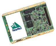
The next step was to somehow create a commercial business out of all this. To do that, in 2000 Mr. Zhou formed Beijing BDStar Navigation Company Ltd. with only himself and another original founder — Mr. Jianhui Li. Based in Beijing, BDStar was ideally located close to the government, close to military management, and close to the BeiDou operations and control centers. Coincidentally, around the same time, NovAtel in Calgary was beginning to be active in the region and was looking for dealers to market its OEM receivers into China. After a trial phase with a couple of dealers, it was finally agreed that BDStar would represent NovAtel exclusively in China.
That’s when I first met Ruxin Zhou — with U.S. WAAS development well underway, it turned out that China was also interested in creating its own Satellite Navigation Augmentation System (SNAS), and was considering NovAtel’s WAAS GI reference receivers for the ground infrastructure. Mr. Zhou became the contact point between NovAtel and BDStar, and what followed was what appeared to us to be a lengthy, frustrating negotiation which rolled out in both China and in Canada. Now we know that not only was the SNAS program making sure it understood the technology inside the NovAtel WAAS receiver, but Mr. Zhou was also learning English, the ways of doing Western commercial business, and, most of all, he was getting to know and be comfortable with us.
NovAtel went on to win three contracts to supply 85 WAAS receivers to the SNAS system over three years, and the relationship with BDStar and Mr. Zhou became one which both sides wished to grow and prosper. NovAtel OEM receivers were also supplied in quantity into a number of applications that BDStar developed in China over many years. BeiDou was also an important catalyst to initially help BDStar gain traction — the company equipped 40,000 fishing boats with BeiDou messaging receivers over several years, used for basic communication across the fleet and for location reporting to monitor authorized fishing areas.
Fast forward to today. Almost 15 years have gone by. Mr. Zhou is now chairman of the board of the BDStar Navigation group of companies, and Mr. Li is president, running day-to-day ongoing business at BDStar. I sat down with my old friend in Tampa at the Institute of Navigation (ION) GNSS + Conference to catch up with the growth and expansion of this business and listen to the many achievements that have now turned BDStar into the largest (¥780 million RMB = $127 million US) GNSS-based public company in China. BDStar had a difficult beginning between 2000 and 2007, like many start-ups, but has now emerged as a profitable leading enterprise within the Chinese BeiDou industry.
Ruxin Zhou, Chairman of the Board, BDStar Navigation.
Ruxin Zhou was born in March 1963, and he has been involved in China’s GNSS industry since 1994. He lives in Beijing, and is the father of two sons. He is also vice chairman of the Association of GNSS of China. He earned his BSc degree in 1983 followed by his master’s in 1989, both at University of NanKai in Tianjin. His MBA was awarded by the University of Beijing in 2003.
Ruxin Zhou considers BeiDou an important part of the GNSS industry, and he is looking forward to cooperating with other GNSS related companies inside and outside China to add more value to users.
Mr. Zhou chairs the BDStar board of directors — one of whom is the president of the company. There is also a group chief technology officer (CTO), a board secretary who is responsible for investment, three outside directors from industry, and an advisor who is familiar with government financial policy. Along with the parent company BDStar Navigation Products Division and its internal GNSS Applications Division, there are nine subsidiary companies, each of which is governed by a small management board.
BDStar Information Service Co. — Largest BeiDou operations service provider.
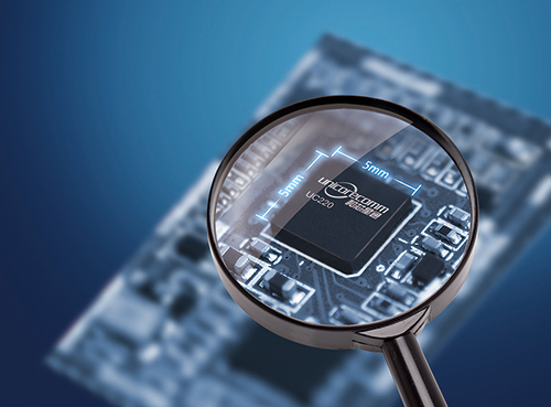
Unicore Communications, Inc. — Consumer and precision chipset and board-level receivers.
BDStar Hong-Kong — Import/export company for the group.
Shenzhen XG Electronics Co. — Vehicle electronics and installations.
BeijingSinsTek Technology — MEMS inertial technologies for defense.
Beijing Hanvic Photoelectricity Co. — Navigation using IR/photo–electric technologies.
BeiDou Information Equipment Co. — National Defense equipment and services.
Recently, the BeiDou Equipment Division within BDStar has become a separate company known as BeiDou Information Equipment Co., and another company — Harxon, which manufactures antennas — is in the process of being added to the group.
The number of people working within the BDStar group has grown from an initial staff of 20 when Mr. Zhou and Mr. Li began operating the company, to around 1,500 people today in 2014.
BDStar Navigation is where this all began as a value-added reseller for NovAtel OEM receivers — integrating them into a number of applications, such as vehicle, marine and military navigation installations. BDStar was also instrumental in the establishment of the ground infrastructure for SNAS and took part in the construction of the system. As this business increased, installations became focused within a separate group, along with building the equipment using integrated NovAtel GPS and inertial OEM equipment — the GNSS Applications Division.
With an increasing number of satellite launches, and a growing ground infrastructure, BeiDou began to become a more important part of China’s GNSS/navigation infrastructure. BDStar began to play a larger role in the emerging BeiDou program (BeiDou System or BDS), and it became clear that BeiDou technology would have to be developed by BDStar in China. And so the spin-off and company start-up phase of BDStar’s growth got underway.
BDStar Information Service Co., Ltd.
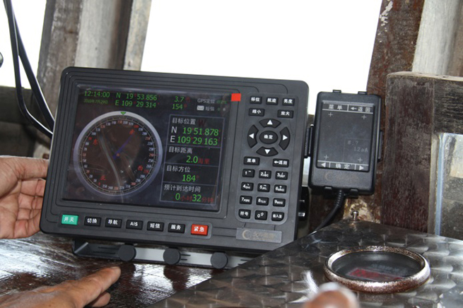
BDStar Information Services Limited is a wholly owned subsidiary of BDStar Navigation, providing location-based system solutions and information services, based on the BeiDou Navigation Satellite System, for the fishery, agriculture, forestry, water conservancy, and meteorology industries. By integrating Internet and mobile communication networks with geographic information, BDStar Information Service has now become the largest BDS information service provider in China with more than 40,000 BeiDou end-users, hundreds of government users and more than 100,000 mobile phone users. The service is 24/7/365 and includes real-time positioning, and short message communication for typhoon warnings, emergency alarms and other related services. The system has capacity for over 100 million navigation positioning and communications messages per year.
Ship terminal. Photo: BeiDouBeidou Operational Service Center. Photo: BeiDou
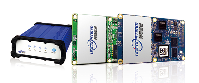
Unicore Communications Inc. (Beijing)
Unicore Communications Inc. is a share-holding subsidiary of BDStar Navigation — a high-tech company dedicated to highly integrated system-on-a-chip (SoC) IC design and GNSS algorithm development. Unicore is focused on the commercialization of BeiDou through advanced GNSS professional applications and innovative technology breakthroughs — one of the leading Chinese companies involved in the “industrialization” of BeiDou systems.
Unicore provides turn-key location-based services (LBS) in both the GNSS professional and consumer navigation segments. An innovative core chip has been independently developed, providing high-performance GNSS as well as low-cost, low-power, high-quality products with positioning accuracy ranging from millimeter all the way up to meter levels. Not only have high-precision requirements for surveying, mapping and CORS reference stations been satisfied, these components have also been used in less onerous applications such as vehicle monitoring and personal navigation.
By the second quarter of 2014, Unicore has sold more than one million BeiDou SoC chips and won multiple breakthroughs in BeiDou multi-GNSS applications such as in-dash automotive navigation, automatic driving test system, Ground-Based Augmentation System (GBAS), and the International GNSS Monitoring and Assessment Service for Open Service (iGMAS).
Beijing Hanvic Photoelectricity is a share-holding subsidiary of BDStar Navigation targeted at the infrared thermal imager market. The company has used in-house infrared optics, imaging circuitry, image processing, artificial intelligence, mechanical structures and system engineering to develop a number of products using planar and linear arrays. Short-medium-long-wave infrared cooling thermal imagers can provide users with a visual context under varying weather conditions from up to tens of kilometers from a target object. These products are widely used in scientific research, electrical distribution, forest-fire prevention, surveillance, public security, firefighting, and anti-smuggling.
Beijing SinsTek Technology Co., Ltd.
Beijing SinsTek Technology is a shareholding subsidiary of BDStar Navigation specializing in the original development of inertial navigation, inertial measurement, and measurement and control systems and devices- for which SinsTek owns all related intellectual property rights. SinsTek has independently developed products such as high-precision quartz accelerometers and gyros, mixed inertial navigation systems, missile-borne computers, a missile overload switch and a ground control system. Products and systems have been widely used within China in various fields of national defense and also commercially.
Shenzhen XuGang Electronics Co., Ltd.
Shenzhen XuGang Electronics was founded as a shareholding subsidiary of BDStar Navigation in 2001. The company undertakes product development, design, manufacture and sales of medium- to high-end consumer-level vehicle audio-video navigation products and services. The company has more than two decades of experience in automobile accessories, and has good cooperative relationships with China’s major automobile manufacturers. With a marketing network that extends across China, the company is one of the most important automotive electronics and navigation products providers in China. Automotive products are also exported to the U.S., Russia, Brazil, Israel and to other countries.
The scope of this business includes:
CAR navigation/CAR audio original design manufacturer (ODM) — High volume/high-quality production of auto accessories, auto electronics and GNSS products.
Marine radio ODM — Waterproof hi-fi player/radios have won wide recognition in Europe and the U.S. This is the only Chinese company whose SIRIUS satellite radio technology has been certified in the U.S.
Telematics auto network solutions — BDStar auto navigation system and BDStar Black Box have been independently developed, fusing sensors, network communications, processing and controlling technologies to provide telematics products and services for auto makers and commercial consumers.
BeiDou online telematics. Photo: BeiDou
Navigation Products Division
The Navigation Products Division has successfully collaborated for more than 10 years with NovAtel as its value-added reseller (VAR) of GNSS and GNSS-inertial products in China. Focused on satellite positioning and inertial navigation applications, BDStar has promoted domestic Chinese navigation and positioning applications development, and has established close cooperative relationships with domestic inertial and integrated mapping companies, research institutes, and other sectors. Application fields include railways, electricity, telecommunications, meteorology, and seismology. Quite naturally, independently developed BeiDou products have also followed this route to market in China.
NovAtel OEM6 receiver. Photo: BeiDou
GNSS Application Division
The GNSS Application Division is the business division of BDStar Navigation, which is mainly engaged in the development, production, sales, and service of the products based on high-precision GNSS technology applications. With the objective of becoming expert in high-precision GNSS solutions used in the developing industry using the “Internet Of Things (IOT),” the company provides a series of GNSS terminal products and solutions for the civilian market. Applications have included agriculture, container ports, and deformation monitoring. Meanwhile, the successful port IOT that this division has provided for Tianjin Port has now been implemented at more than 20 domestic and foreign ports including Shanghai, Ningbo, Shenzhen, and in India.
BeiDou Internet of ships Photo: BeiDou
BeiDou Information Equipment Co.
BeiDou Information Equipment, a wholly owned subsidiary of BDStar Navigation, is focused on supplying products for national defense and government agencies, and provides complete solutions and products for dispatch management of hazardous materials and special cargo handling. Several successful projects have been undertaken, including special hazardous vehicle command and monitoring, public security, anti-terrorism, forest-fire prevention, emergency management, personnel command and monitoring of disaster relief, public security, and border defense. The division relies on its experience in system engineering, command and control software, radio system design, and military satellite navigation to provide users with terminal products such as navigation, timing and heading, and location-based military information service systems. Specific products developed include terminal equipment, vehicle-mounted navigators, vehicle traveling data recorders, police positioning and telecommunication terminals, and an emergency communication system.
Following this phase of significant growth, what does the future hold for BDStar? We know that China’s huge annual rate of GDP growth may have slowed a little, but Mr. Zhou still has pretty big aspirations for his group of companies. His target for 2020 is to have BDStar reach annual sales of 10 billion RMB ($1.63B US). To get there, his intermediate step is to reach 2 billion RMB ($326m US) by the end of next year. Overall, this represents a ten-fold growth in revenue over six years — by Chinese industrial standards, this might even be termed “modest” growth.
But where will all this growth come from? The strategy appears to be textbook:
Through significant organic (internal) growth, or by doing the same things better and to a greater extent.
Through strategic partnerships with targeted leading companies in key growth areas.
Through further acquisition of companies that would improve the bottom line and also benefit from the synergies of the existing corporate group.
While the anticipated course would be to add companies at the corporate level, it’s possible that some companies within the organization may also get to the point where they see adding an organization below or alongside may become a profitable avenue for their own growth. Of course, other suitable companies in China would be on Mr. Zhou’s strategic acquisition list, but he’s also looking for expansion elsewhere around the world. The U.S. market is significant for the type of products and technologies available in the BDStar group, so it would be natural to anticipate that a North American acquisition could help improve product distribution and development. As BeiDou becomes an integral part of global GNSS, and industry partners seek more than Open Service capability and better Chinese access, its also conceivable that partnerships with North American players could come about.
So, at least with BDStar and some other similar Chinese companies, it would seem that those earlier 1990s aspirations of the Chinese government to create a commercial economic sector within the Chinese economy have at least begun to show a measure of success in the GNSS market segment.
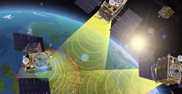
EGNOS is Europe’s first venture into satellite navigation. EGNOS broadcasts augmented information through a trio of geostationary satellites linked to a network of monitoring ground stations, to sharpen the accuracy and reliability of GPS signals across the continent. Photo: EGNOS
Europe’s EGNOS augmentation system sharpens the accuracy and reliability of GPS signals so they can safely be used for landing approaches across a growing number of European airports. But aviation is a global enterprise — so the aim is to develop a seamless network of augmentation systems in future.
That is the task of an international group of experts, the Satellite Based Augmentation Systems (SBAS) Interoperability Working Group (IWG), whose 27th meeting took place in Tampa, Florida, September 8-10, hosted by the Institute of Navigation.
Satellite augmentation systems combine dedicated ground stations and satellite transponders to sharpen satnav accuracy and provide integrity data — providing continuously updated reliability levels — across given geographical regions. These systems are based on GPS for now, but plans are to move to a multi-constellation design in the post-2020 era, making use of Europe’s Galileo, China’s Beidou and Russia’s GLONASS systems as well.
SBAS providers from around the globe gathered at Tampa, Florida, for the latest meeting of the SBAS Interoperability Working Group September 8-10. IWG 27 was hosted by the Institute of Navigation. Photo: SBAS
SBAS systems enhance any type of location-based satnav use, but in practice, aviation is the main driver. The ESA-developed European Geostationary Navigation Overlay Service, EGNOS, commenced its general-public Open Service in 2009, with the Safety-of-Life Service for aircraft vertical landing approaches following in 2011.
For next-generation SBAS systems, the IWG is designing a multi-constellation and dual-frequency standard for heightened accuracy and reliability, building up to offering SBAS coverage on a worldwide basis.
Didier Flament, representing ESA — which co-chaired this IWG meeting with the U.S. Federal Aviation Authority — commented: “Among the achievements of the Tampa IWG has been the presentation of an ongoing review of a standard message definition for the new and second SBAS channel — known as L5 — of the second-generation SBAS system, to be used along with the current L1 signal.
ASECNA Member States.
“A single definition coordinated between ESA and the European Commission on one side and the U.S. Federal Aviation Administration on the other is progressing. The formal IWG review loop has started, with the aim of finalizing the convergence for early 2015. The aim is to have it ready to submit to the international SBAS standardization bodies — the International Civil Aviation Organization (ICAO), the U.S. Radio Technical Commission for Aeronautics and the European Organization for Civil Aviation Equipment — in the first quarter of next year.”
The meeting also introduced two new SBAS development projects, adding to the five existing projects presented at IWG 26. The first was presented by the Agency for Air Navigation Safety in western Africa and Madagascar (ASECNA), a public international organization with 18 member states.
China’s BeiDou SBAS development plan, presented at IWG 27 in September 2014.
ASECNA’s project aims to take a two-step approach, commencing with EGNOS-style vertical landing guidance for selected airports, based on EGNOS constituents, with a tentative schedule of 2018, moving to upgrade to the dual-frequency multi-constellation service across the whole of ASECNA airspace after 2020.
The second new project is China’s own BeiDou SBAS. After discussions at ICAO level, China has committed to delivering SBAS services over China that are fully compliant with ICAO standards.
“This new plan has been highly welcomed by the aviation community and other SBAS providers,” Didier said. “Chinese representatives have also confirmed their intention to become part of the SBAS IWG and contribute to the work done to finalise the future standard.”
The follow-up IWG meeting will take place in February 2015 and will be hosted by ASECNA in Dakar, Senegal.
About EGNOS
EGNOS, the European Geostationary Navigation Overlay Service, is Europe’s first venture into satellite navigation. Its development was managed by the European Space Agency (ESA) under a tripartite agreement with the European Commission (EC) and the European Organization for the Safety of Air Navigation (Eurocontrol).
The ownership of the EGNOS assets was transferred from ESA to the EC in April 2009 and EGNOS officially entered service on October 1, 2009. The service is delivered, through a contract with the European GNSS Service Agency (GSA), by the European Satellite Services Provider, ESSP SaS, founded by seven air navigation service providers. ESA is the design and procurement agent for EGNOS on behalf of the EC.
The chief of Russia’s space agency Roscosmos has discussed plans for bilateral cooperation in space with his Chinese counterparts in Beijing, according to the ITAR-TASS news agency.
“On Thursday, the chief of Roscosmos held a meeting with the head of China’s Satellite Navigation Office Ran Chengqi. The officials discussed Russian-Chinese cooperation on navigation satellite systems GLONASS and Beidou, in particular, the placement of Russian stations in China and Chinese stations in Russia,” the Roscosmos press service said.
The two sides agreed to establish a sub-commission for cooperation in the sphere of satellite navigation under the bilateral commission in charge of preparing regular meetings of the two countries’ prime ministers.
Earlier, Roscosmos deputy chief Sergei Savelyev said that Moscow this year would sign an agreement with Beijing on deploying GLONASS and Beidou stations in China and Russia respectively. Each country will accommodate three such facilities.
I attended the China Satellite Navigation Conference in Nanjing in May, the fifth year of CSNC and my third time attending. Tremendous progress was evident this year in terms of BeiDou (BDS) deployment and China’s general openness and willingness to collaborate over those years. I have also seen a slowly growing international presence at the show and expect that to continue to increase as well. You may recall my column last year about Little Tigers. Well, they aren’t so little any more. As for the tycoons, you will have to read to the end.
The conference opened with the usual provider updates. Chenqi Ran, who runs the China Satellite Navigation Office, the lead government agency for BDS, started off. It’s always good to hear his update delivered in China, where the is a little more freedom to provide information beyond the standard pitch. China continues on pace to its plan for the third step of BDS with five geosynchronous-orbit, three inclined geosynchronous-orbit, and 27 mid-Earth orbit satellites for a worldwide system by 2020. They are meeting their stated goal of 10-meter accuracy regionally today, and as good as 5-meter near the Equator. Ran also provided interesting numbers for the fast-growing Chinese domestic market:
More than 2 million BDS chips sold in China in Q1
More than 300,000 vehicles equipped with BDS
20 domestic brands offering car navigation systems
First consumer tablet (Samsung Galaxy Note 3) with BDS.
First consumer smartphone (Huawei B199) with BDS
The updates from other providers (GPS, GLONASS, and Galileo) were relatively standard and did not contain much new information. I had hoped that maybe the Russian presentation would provide more information about the April outages, but nothing was forthcoming and I was not overly surprised.
The conference itself is very well organized and runs nine parallel technical tracks over two full days, with additional special-interest sessions. All of the presentations are in Chinese, however the conference provides headsets for simultaneous translation, and many presenters have dual slide sets in Chinese and English, so it is easy to attend anything that seems interesting.
I came as an invited speaker on the Institute of Navigation (ION) panel organized by Professor Jade Morton from Miami University, Ohio, and Professor Lu of the National Timing Service Center near Xian. The ION panel was well attended and included a short panel discussion at the end.
One of the most interesting outcomes was that both Broadcom and Trimble showed approximately 25 percent accuracy improvement by adding Beidou to their existing GPS/GLONASS solutions. It was interesting not just because they reached the same number, but because Broadcomm was talking in meters about urban-canyon performance and Trimble was talking in centimeters about precise positioning.
It became clear that everyone sees BDS as an important part of their roadmap at L1, regardless of how many frequencies they currently support. I must also note that both Professor Morton and Professor Lu were outstanding hosts and showed us some of the wonderful local sites.
Exhibit Hall
The biggest change from last year was in the exhibit hall. I would estimate the overall floor space grew by 50 percent, with 106 companies in specially designed booths (up from 56 last year) and another 44 in standard booths.
The content change was even more dramatic. Last year there were a lot of small booths with pretty basic displays, mostly of prototypes and slideshows. This year, there were many more extremely large booths that were very professionally created. They had evolved into displaying very polished-looking finished products with nicely edited videos. It was clear that this was all targeted at domestic buyers, as it was difficult to find anyone on the show floor who spoke English (except in the Spirent booth). These are no longer little tigers. These are now real companies, out hunting for new business.
Policy and Intellectual Property
My other favorite topic to listen to at this conference is on policy and intellectual property (IP). That is where I spent most of my time and was not disappointed. There was in fact an entire session dedicated to intellectual property, and several presentations on the global state of affairs of patents in GNSS.
Interestingly, most of the speakers were either lawyers or from government, but there were some corporate ones as well. Several speakers highlighted the recent disagreement and settlement of the patent dispute between the United States and the United Kingdom over complex modulation patents. There was a large element of underlying concern that although the U.S. had been able to settle the dispute, it might be very hard for China if either the U.S. or the UK came after them. They had several charts showing how far behind they were in GNSS patents, in an effort to encourage local companies to create more IP and patent it. They also showed they have made significant progress in recent years in domestic Chinese patents, though they still have a long way to go in international patents.
They were also very concerned about the largest holders of GNSS patents in China — Qualcomm and Broadcom — as a threat to domestic industry. They cited the GlobalLocate/Broadcom versus SiRF/CSR lawsuit as a cautionary tale. Several presenters showed the dominance of Broadcomm and Qualcomm in terms of domestic Chinese patent holdings and referred to them as the “Tycoons.” I envisioned Rich Uncle Moneybags, the guy from the Monopoly game wearing the top hat, walking around with patents instead of dollar bills hanging out of his hat.
Conclusion
The little tigers have definitely grown up. They are much bigger, have real teeth, and are definitely trying to stake out territory in the fast-growing domestic market. But the Tycoons still have the upper hand in the mass-market battle for consumer devices. For the moment, anyway.
The Tycoons are going to have to start spending some of their bounty in China if they want to maintain that market share against rapidly evolving domestic competition. I won’t be surprised if next year we see the Tycoons exhibiting at CSNC, and soon after that, the tigers looking to expand their hunting ground into nearby markets in Korea, India, and Japan.
Greg Turetzky is a principal engineer at Intel responsible for strategic business development in Intel’s Wireless Communication Group focusing on location. He has more than 25 years of experience in the GNSS industry at JHU-APL, Stanford Telecom, Trimble, SiRF, and CSR. He is a member of GPS World’s Editorial Advisory Board.
The statements, views, and opinions presented in this article are those of the author and are not endorsed by, nor do they necessarily reflect, the opinions of the author’s present and/or former employers or any other organization the author may be associated with.