China’s BeiDou navigation industry in 2025 achieved a total output value of 1.33 trillion yuan (US$195 billion), according to a report released Monday by the GNSS and Location Based Services (LBS) Association of China, or GLAC, reports CGTN.
The BeiDou industry includes remote sensing and geographic information systems (GIS), mobile communications and indoor positioning. The satellite navigation sector generated 629 billion yuan (US$92 billion) in 2025, up 9.24% year on year, according to the report.
China has established a complete BeiDou industrial chain and supply chain, covering chips, modules, antennas, terminals, system integration and application services, , according to the report. Domestic capabilities are becoming increasingly self-reliant, with the cumulative shipments of BeiDou-compatible chips and modules reaching hundreds of millions, supporting a secure and robust industry supply chain.
Domestic sales of BeiDou-enabled terminals exceeded 410 million units in 2025, with more than 2.2 billion BeiDou-capable devices in use across the country.
Internationally, BeiDou services and related products have been exported to more than 140 countries and regions.
China has launched a short messaging service leveraging BeiDou (BDS) to provide reliable communication during emergencies when ground-based mobile networks are unavailable, reports Xinhua.
The service was introduced by China Space-Time Information Co. Ltd., the national operator of BeiDou services, in collaboration with major domestic telecom carriers.
The service is be a supplement to terrestrial mobile networks, expected to enhance safety and communication reliability for users across scenarios such as hiking in remote mountains, working at sea, and disaster relief and emergency coordination.
It marks a significant step toward bringing satellite communication technology to the public, integrating BeiDou’s capabilities into daily life and offering tangible technological protection.
The service uses the short-message communication capability built into the BeiDou system, enabling users with compatible smartphones to send and receive text messages directly via BeiDou satellites in areas without cellular coverage.
China’s three primary telecom operators — China Mobile, China Telecom and China Unicom — have all integrated the service. Subscribers can activate the service without changing their SIM cards or phone numbers, according to the company. Nearly 60 smartphone models from leading Chinese brands already support the functionality.
China Space-Time Information specializes in satellite navigation and communications, big data services, artificial intelligence development, and geospatial remote sensing.
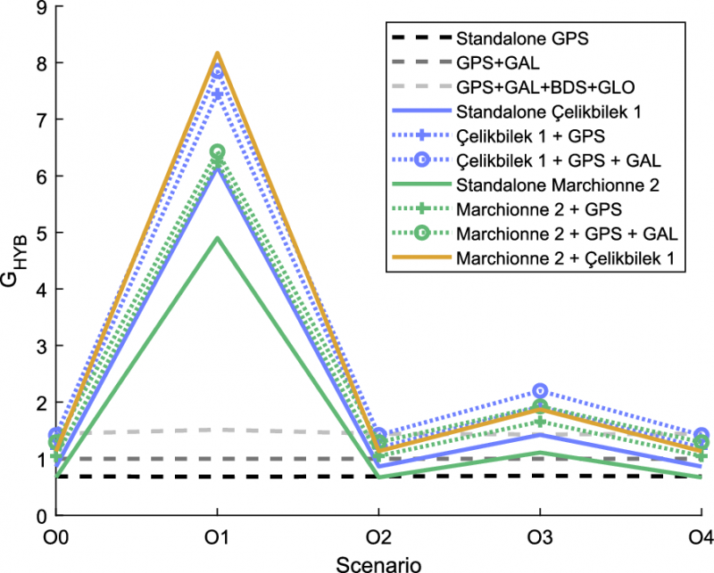
Low-Earth orbit (LEO) systems have emerged as a promising complement to GNSS, offering higher received power, better satellite geometry and broader spectrum options. Researchers aim to evaluate whether LEO-PNT can complement or enhance GNSS performance through large-scale simulations and design comparisons.
Researchers from Tampere University and Universitat Autònoma de Barcelona published (DOI: 10.1186/s43020-025-00186-5) a comparative analysis in the December 2025 issue of Satellite Navigation. The study investigates how different LEO constellation configurations perform in positioning accuracy and interference robustness when operating alone or jointly with GNSS.
Using semi-analytical modeling and 192,000 Monte Carlo simulations, the team evaluated 400 users across European regions in five outdoor scenarios. Key variables included carrier bands (1.5/5/10 GHz), effective isotropic radiated power (EIRP) levels and constellation geometry design.
The team simulated multiple standalone and hybrid constellation architectures, analysing carrier-to-noise ratio (C/N0), geometric dilution of precision (GDOP), position dilution of precision (PDOP) and lower bound 3D accuracy.
Results indicate that an EIRP of 50 dBm is sufficient for high-quality outdoor positioning when operating in L- and C-bands. While 10 GHz platforms require higher power to compensate for path loss, hybrid LEO + GNSS modes show markedly improved stability and reliability.
Multi-shell constellations such as Çelikbilek-1 and Marchionne-2 delivered a favorable balance between satellite count and global geometry, outperforming single-shell layouts. In harsh urban canyon conditions, GNSS accuracy degraded up to seven-fold, whereas LEO-PNT maintained stable ranging performance with limited loss.
Interference resistance also improved. Stronger LEO signal power means jammers require far greater intensity to cause equal degradation. Hybrid designs provided the most significant gains. Combinations such as Çelikbilek-1 + GPS/Galileo, or CentiSpace + BeiDou, yielded better PDOP distributions, faster fix availability and broader user coverage.
The authors conclude that LEO systems are not aimed at replacing GNSS, but rather to enhance availability and resilience under signal-challenged environments.
“Our results show that moderate-power LEO constellations can substantially strengthen outdoor positioning without requiring expensive satellite hardware,” the authors noted. “Geometry plays a major role — carefully designed multi-shell constellations achieve strong accuracy even with fewer satellites. As LEO-PNT develops, hybrid integration with GNSS offers the most cost-effective path toward secure, robust PNT solutions. This work provides guidance for future system designers evaluating frequency, transmission power and constellation configuration trade-offs.”
The findings suggest a realistic rollout pathway for resilient satellite navigation. LEO-enhanced PNT could benefit autonomous vehicles, UAV routing, emergency response, precision farming and critical infrastructure monitoring — especially where GNSS falters in interference-dense or high-rise environments.
Lower-power LEO transmission also reduces deployment cost, opening access for commercial operators.
Future work may assess indoor positioning potential, bandwidth expansion, and real-orbit testing to refine simulation assumptions. As global demand for secure PNT grows, the integration of LEO and GNSS could become a cornerstone for next-generation navigation technology.
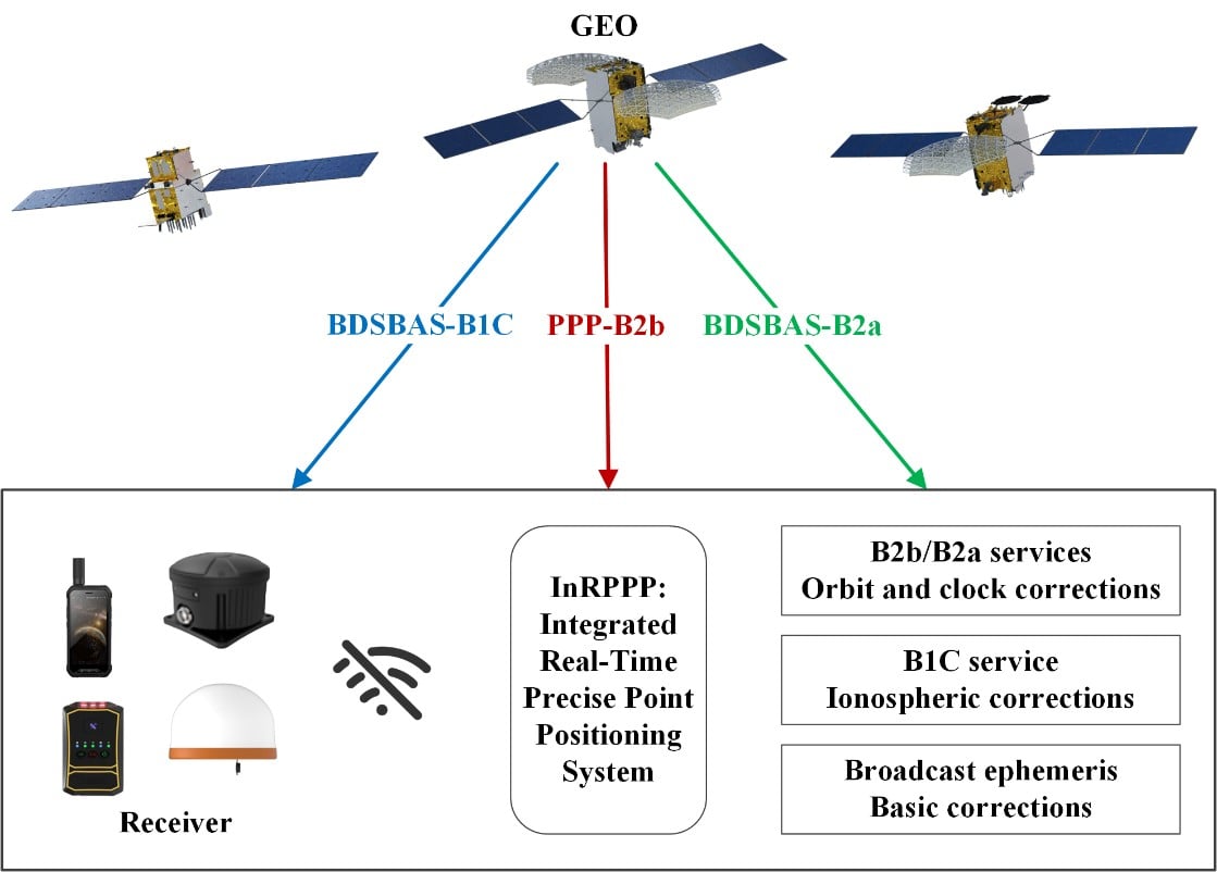
The development of an Integrated Real-Time Precise Point Positioning (InRPPP) system leveraging BeiDou Navigation Satellite System (BDS) B2b, B2a, and B1C services has significantly enhanced satellite-based positioning accuracy.
By resiliently utilizing these augmentation messages, the InRPPP system corrects satellite orbit and clock errors and mitigates ionospheric delays, outperforming traditional methods. Experimental results from both static and kinematic conditions demonstrate superior performance, showing improved positioning accuracy, faster convergence times, and greater stability in challenging environments. This breakthrough offers potential for applications in real-time navigation, precision positioning, and disaster monitoring, with a broader impact on industries requiring reliable and continuous positioning data.
The implications of the InRPPP system are vast, with applications spanning multiple sectors that depend on high-precision satellite navigation.
Satellite-based navigation systems, like the Real-Time Precise Point Positioning (RTPPP), are crucial for many industries that require accurate location data. However, these systems face limitations in areas with weak Internet connectivity or signal interference. BeiDou’s satellite augmentation services, namely B2b, B2a, and B1C, have emerged as a promising solution.
Yet, integrating these services into one cohesive system for optimal performance remained unexplored. This study pioneers the Integrated InRPPP system, which integrates all three services including correcting satellite clock, orbit errors, and ionospheric delays, unlocking new levels of positioning accuracy. The results from this research address critical limitations in current satellite-based positioning technology, setting the stage for real-world applications in complex environments.
In a 2025 Satellite Navigation publication (DOI: 10.1186/s43020-025-00172-x), researchers from the State Key Laboratory of Geo-Information Engineering and Key Laboratory of Surveying and Mapping Science and Geospatial Information Technology of MNR, State Key Laboratory of Spatial Datum, and Hohai University introduced the InRPPP system, a new approach that leverages the B2b, B2a, and B1C services of the BDS.
Scenes of the static experiment. The left and right panels denote the west and south sides of the station. (Photos: Study authors)
By combining these services, the InRPPP system corrects satellite orbit and clock errors while mitigating ionospheric delays. With enhanced accuracy, stability, and faster convergence times, this system has the potential to transform satellite-based positioning, offering more reliable and continuous service in real-time applications, especially in environments where traditional positioning systems struggle to perform.
The InRPPP system brings a new level of precision to satellite navigation by combining the best of BeiDou’s B2b, B2a, and B1C services. Through this integration, the system corrects satellite orbit and clock errors with B2b and B2a services, while B1C handles ionospheric delays. This resilient approach allows the system to deliver superior performance, even in high-occlusion or remote environments. The static experiments showed the InRPPP system surpasses other methods, with a 59.6% improvement in positioning accuracy and a 65.9% reduction in convergence time compared to using B2b, B2a, or B1C individually.
In dynamic conditions, the system demonstrated enhanced stability and reduced signal interruptions, achieving up to a 34.3% improvement in accuracy. The integration of these services increases the number of visible satellites, enhancing the Position Dilution of Precision (PDOP) values and ensuring better satellite geometry. This integrated approach not only improves accuracy but also ensures continuous, reliable solutions, making it a game-changer for fields like geodesy, navigation, and disaster monitoring.
Academician Yuanxi Yang of the Chinese Academy of Sciences, the lead researcher behind the InRPPP system, remarked, “The ability to integrate multiple BeiDou augmentation services into a single real-time positioning system represents a major breakthrough. By leveraging B2b, B2a, and B1C, our system offers a more reliable and accurate solution than anything available today. In both static and kinematic tests, the InRPPP system has outperformed traditional positioning methods, demonstrating its robustness and resilience in environments where signal conditions are far from ideal. This system is already applied in real applications and has potential to reshape industries reliant on satellite navigation and positioning.”
The implications of the InRPPP system are vast, with applications spanning multiple sectors that depend on high-precision satellite navigation. From autonomous vehicles and precision agriculture to disaster management and geospatial services, the enhanced accuracy and stability offered by InRPPP can support real-time decision-making in critical environments. This system also promises to improve the resilience of navigation systems in regions with poor satellite visibility or signal interference. As technology advances, the InRPPP system could pave the way for even more robust solutions, advancing global sustainability goals and improving disaster response capabilities by offering uninterrupted, reliable positioning data.
China’s BeiDou satellite navigation system (BDS) has secured approximately $1.78 billion in funding for new projects, positioning itself to compete more effectively with its primary rival, GPS. This significant financial boost was announced at the Third International Summit on BDS, coinciding with the system’s 30th anniversary.
The investment package includes $1.1 billion, which is designated for adopting BeiDou in both industrial and consumer applications, according to Hunan Daily. Part of the funding has been allocated to an Indonesian disaster prevention agency for the development of an early warning system.
China’s Ministry of Industry and Information Technology has also selected 39 pilot cities for large-scale BDS applications. These cities are expected to increase BDS usage rates as the system transitions into its third-generation phase. This aims to expand BeiDou’s domestic footprint and showcase its capabilities on a broader scale, according to China’s Ministry of Industry and Information Technology.
BeiDou is gaining traction in Africa and Southeast Asia, which could challenge GPS’s long-standing dominance. As more countries adopt the Chinese system as their primary GNSS, BeiDou’s prominence increases compared to GPS. China launched two new satellites in Sept. 2024, bringing the total number of active satellites in the BeiDou constellation to 50. These newly launched satellites, part of the third-generation model, represent the second batch placed into medium-Earth orbit (MEO) since the system was declared operational in July 2020. With 64 satellites launched, China continues to expand and enhance the BeiDou system.
Successful launch of the 59th and 60th BDS satellites on Sept. 19, 2024. (Photo: International Cooperation Center of China Satellite Navigation Office)
Upholding the principles of “superior construction, excellent management, and substantial development,” the BeiDou Navigation Satellite System (BDS) implements multifaceted strategies to ensure uninterrupted and stable system operations and services, with its backup satellites launched into orbit as per the scheduled plan in 2024. Concurrently, research on next-generation BDS technology upgrades and related technological trials for integration with low-Earth orbit (LEO) positioning, navigation and timing (PNT) systems are vigorously promoted, further enhancing international collaboration and propelling the continuous advancement of BDS in the new era.
1. System operation and services
All figures provided by the author.
BDS currently consists of 45 operational satellites in orbit, delivering services through 15 BDS-2 and 30 BDS-3 satellites. Since May 2023, five BDS-3 backup satellites have been launched to bolster system resilience.
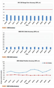
According to the monitoring data from the International GNSS Monitoring and Assessment System (iGMAS) and the International GNSS Service (IGS) in 2024, BDS achieves a service availability of 100% and exhibits a single satellite signal continuity of 99.991% per hour, with signal-in-space accuracy surpassing 0.9 meters (95%), broadcast ephemeris accuracy surpassing 0.2 m (95%), single frequency three-dimensional positioning accuracy of the B1C signal better than 6 m (95%, global average), and the B1C/B2a dual-frequency three-dimensional positioning accuracy superior to 3 m (95%). The timing accuracy is noted to be better than 10 ns (95%). The performance of the BDS PNT service has consistently met all performance requirements.
Figure 1 illustrates the spatial signal accuracy of the BDS B1C signal. Figure 2 presents the broadcast orbit accuracy of the BDS B1C signal. Figure 3 showcases BDS’ global positioning accuracy for both single-frequency and dual-frequency.
Through the BeiDou Satellite-Based Augmentation System B1C (BDSBAS-B1C) and the BeiDou Satellite-Based Augmentation System B2a (BDSBAS-B2a) signals, BDS offers single-frequency BDSBAS service that meets APV-I requirements and a dual-frequency multi-constellation service that meets CAT-I requirements for China and surrounding regions. The ionospheric grid model has been persistently refined to enhance the performance of the satellite-based augmentation services at the peripheries. Evaluation results reveal that the BDSBAS service attains a single-frequency positioning accuracy of 1.29 m (95%) horizontally and 1.99 m (95%) vertically, and a dual-frequency positioning accuracy of 0.77 meters (95%) horizontally and 1.41 m (95%) vertically.
BDS disseminates precise orbit and clock difference corrections and inter-code biases via the precise point positioning (PPP)-B2b signal, providing PPP services to China and surrounding areas. Evaluation results indicate that the BDS-only precise point positioning accuracy is 0.16 m (95%) horizontally and 0.22 m (95%) vertically, with a convergence time of less than 20 minutes.
In 2024, building upon its PNT services, BDS actively offers diversified specialized services, including regional short message communication, global short messaging, and international search and rescue. The number of user terminals for regional short message communications continues to grow. Based on inter-satellite links, global short messaging services can provide users with global random-access capabilities. These services have been applied in projects such as the Einstein Probe mission, the SVOM satellite in collaboration with France, and gravitational wave detection satellites, achieving instant return of global detection data. While six medium-Earth orbit (MEO) satellites are equipped with international maritime search and rescue payloads, the BDS return link enables transmission with a communication delay of less than 12 seconds, and a success rate of 96.82%, suitable for distress alert feedback, disaster information broadcasting and other multi-application scenarios.
The stable BDS operation ensures the consistent and rapid improvement of application industries and the expansion of application scenarios. In 2023, the total output value of China’s satellite navigation and location-based service industries reached more than RMB 530 billion, marking a growth of more than 7% compared to 2022.
2. System construction and development
In May 2023, a backup geostationary orbit (GEO) satellite was launched, followed by two additional MEO backup satellites launched in December 2023, featuring upgraded global short message communication capacity and enhanced intelligent payload technologies. These backup satellites have successfully completed in-orbit testing and are now ready to provide services as needed. In September 2024, another pair of MEO backup satellites, equipped with innovative atomic clocks and a new type of inter-satellite links, were deployed. These backup satellites improve system reliability and service performance and facilitate experimental validation for next-generation satellite technology upgrades.
To continuously enhance system service performance, BDS has developed precision and stability enhancement plans for both the ground control system and the in-orbit satellite support system. Efforts include intensifying satellite-based and ground-based multi-source data fusion analysis, conducting regular assessments of constellation and ground system statuses, and improving fault automatic diagnosis, response efficiency, and intelligence capacity.
China is actively promoting the integrated development and experimental validation of BDS and LEO satellite navigation augmentation systems. Leveraging several test satellites within the under-construction LEO constellation, experiments including GNSS+LEO FPPP have been conducted. Results demonstrate that GNSS orbit determination accuracy is better than 5 cm (1σ), and clock error determination accuracy is superior to 0.15 nss (1σ). With signal enhancement from two to three LEO satellites, PPP positioning accuracy reaches 0.3 m with a convergence time at the minute level, thereby enhancing high-precision service performance and reducing PPP convergence time.
In May 2023, China successfully launched the first BDS-3 GEO backup satellite. (Photo: International Cooperation Center of China Satellite Navigation Office)
3. International coordination and cooperation
China has been deeply involved in international satellite navigation. Since 2023, China has actively participated in a series of events under the United Nations framework, including the ICG-17 and the United Nations Workshop on the Application of Global Navigation Satellite Systems, contributing to the global advancement of satellite navigation. China has engaged in deep collaboration with system providers from the United States, Russia and the European Union to facilitate compatibility and interoperability, covering navigation signal structures, time systems, coordinate frameworks, test and assessment. Meanwhile, discussions are held with regional navigation satellite systems and emerging systems on topics of mutual interest, such as high-precision services and emergency alert services. In 2024, the BDS timing service was officially included in the Time Bulletin by the Bureau International des Poids et Mesures (BIPM), signifying international recognition of the ability to provide precise and reliable standard time services globally.
China continues to expand its international partnership with BDS. In recent years, events including the BDS/GNSS Global Partner Forum, the China-Africa BDS Cooperation Forums, the China-Arab States BDS Cooperation Forums, the China-Central Asia BDS Cooperation Forums, the International Training Workshop on BDS Technologies and Applications in the Belt and Road Countries and Regions and the International Summit on BDS Applications have been held to share the benefits of BDS/GNSS applications globally.
BDS will continue to uphold the vision of “a first-class navigation satellite system developed by China and dedicated to the world.” It will make every effort to ensure the stable operation, steady upgrades, and advancements of the system, as well as in-depth research in technologies such as low-orbit PNT and lunar PNT, furthering the commercialization, industrialization, and internationalization of BDS applications
China’s BeiDou high-precision navigation and positioning service platform has entered trial operation, The National Geomatics Center of China reported.
Developed under the leadership of the Ministry of Natural Resources, the platform integrates satellite navigation and positioning base stations nationwide within the natural resources system. This initiative consolidates more than 3,300 base stations into a unified network, offering centralized management of station resources.
The network offers seamless, high-precision positioning services nationwide, delivering real-time, accurate and reliable navigation for sectors including public welfare mapping, resource surveying, intelligent transportation, autonomous driving, precision agriculture and social governance.
The service is available both online and offline. Online, it offers real-time observation data and enhanced positioning services. Offline, the platform delivers coordinate results, post-event observation data files, and related products.
The BeiDou Navigation Satellite System (BDS) was initiated in 1994. The construction of BDS-1 and BDS-2 was completed in 2000 and 2012. When BDS-3 was completed and put into service on July 31, 2020, China became the third country to have an independent global navigation satellite system.
Current state of the art multi-frequency GNSS receivers operate by receiving L1 first and then L5. L5-first is a viable answer to the call for more resilience in GNSS as is being discussed in government and technical circles to protect vital national infrastructure. It is suggested as part of “Toughening Category 4: Signal Alternatives” to protect, toughen and augment (PTA) the current GNSS systems described by Brad Parkinson’s article in the March 2022 issue of GPS World.
Paul McBurney
The need arises from attacks directed by bad actors on a large scale, such as electronic warfare, and on a more humane scale, by bad actors such as self-jammers and spoofers. On top of that, normal interference can cause desensitization and denial of service on GNSS receivers from myriad terrestrial and satellite communications.
The PTA plan presents the Denial Radius Reduction Ratio (DRRR) figure of merit and shows that a J/S increase of 15 dB produces a DRRR of 0.18. Whereas a receiver without this additional 15 dB of J/S could be denied fixing out to 1 km from a given transmitter, a receiver with an additional 15 dB J/S would be denied out to only 180 m from the same transmitter.
The improvement in terms of area is proportional to radius squared. The article identifies that the J/S capability is different among GNSS signals and the best performance is obtained with L5, mainly because it has the highest chipping rate. L1C has a code length of 10,230 chips, the same as L5, but it is spread over 10 msec and has the same chipping rate as L1 C/A.
There are currently 72 L5 signals between GPS, Galileo, BeiDou and QZSS transmitting the same physical layer features of 10.23 MHz chipping rate, 1 kHz overlay codes and higher transmit power compared to nearly all L1 signals with a 1.023 MHz chipping rate and lower transmit power. The combination of these features at L5 is close to achieving this 15 dB performance level over L1.
Unlike current hybrid receivers, L5-first survives L1 jamming. (Photo: Carkhe / iStock / Getty Images Plus / Getty Images)
One might conclude that the current start of the art of a receiver with both frequencies (aka, a hybrid L1+L5) has this resilience. However, the market does not currently offer the ability to directly acquire L5 signals overall use cases of GNSS assistance without first acquiring signals at L1. This means they can only achieve this resilience when the interference is encountered after acquiring and fixing at L1. As soon as the L1 is lost and the position and time uncertainty grow beyond the receiver’s capacity to autonomously search for L5 signals, the receiver is denied service at the interference level tolerable at L1. If you cut the receiver into L1 and L5 pieces, only the L1 side is capable of fixing autonomously. As noted by Dennis Akos et al. (“Testing COTS GNSS Receivers Using Only a Subset of Supported Signals,” ION JNC 2023), “support for several signals/frequencies provides integrity and robustness.” Specifically, “under jamming scenarios, signal diversity can allow a receiver to still generate an accurate position solution.”
Current receivers are not able to acquire L5 for reasons related to history, cost and power consumption. Historically, the promise of L5 accuracy was so attractive that it was added to legacy chipsets based on L1 even when it was only partially deployed. It was impractical at that time to require L5 acquisition when there were fewer L5 satellites than at L1. Cost and power are related to the fact that L1 receivers’ acquisition methods are sized to acquire the L1, E1, B1 and G1 signals. Memory and compute capacities, including the digital clock speed, are sized for slower chipping rates and hence shorter code lengths. At this performance level, conventional time domain correlation is adequate. Some receivers deploy frequency domain methods at L1 and achieve a lower cost and power than time domain methods with similar capacity. However, the L5 acquisition complexity with time domain correlation is 100 times more than L1 as its complexity increases with N2, meaning the cost and power to acquire L5 is out of reach. While using a time domain acquisition engine to acquire L5 may be possible for strong signals when the code and frequency search space is constrained for those signals, directly acquiring L5 with conventional methods would have serious shortcomings in many use cases.
Interestingly, the signal designers across all GNSS systems have cleverly designed the L5 signals so they can be easily acquired after acquiring their counterparts on L1. The L5 primary and secondary code is predictable based on learning the L1 primary code and navigation data bit phase. E5a and B2a primary and secondary codes can be predicted by learning the well-designed E1/B1 primary and secondary code phases that have the same total period: the combination of the 4 msec code lengths synchronous with 25 bits of secondary code are in phase with the E5a 100 msec overlay code. After an L1 fix with fine time, L5 can similarly be directly acquired easily with limited searching.
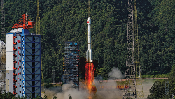
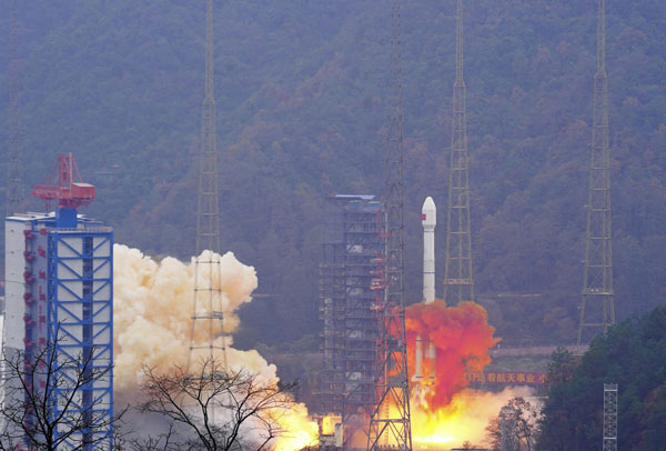
China has launched two satellites into medium-Earth orbits (MEO) for its BeiDou Navigation Satellite System, reported the China Satellite Navigation Office.
The satellites were carried by a Long March 3B rocket from the Xichang Satellite Launch Center in Sichuan province and are the 13th group of third-generation BeiDou satellites operating in MEO.
The two spacecraft will start formal operation after a period of in-orbit technical verification, according to the China Satellite Navigation Office.
BeiDou is China’s largest civilian satellite system and one of four global navigation networks, along with the United States GPS, Russia’s GLONASS and the European Union’s Galileo.
Since 2000, a total of 62 BeiDou satellites, including the first four experimental ones, have been lifted on 46 Long March 3 series rockets from Xichang.
In June 2020, the final satellite to complete Beidou’s third-generation network was lifted by a Long March 3B rocket launched from the Xichang center. The following month, the system was declared complete and began providing full-scale global services.
Nearly 50 Beidou satellites in active service, including the latest pair.
Fifty years since it was designed and approved by the U.S. Department of Defense (DOD), the GPS is at risk of losing its status as the world’s gold-standard location service, reported The Wall Street Journal.
In a recent paper published by Harvard’s Belfer Center for Science and International Affairs, “China’s BeiDou: New Dimensions of Great Power Competition,” Sarah Sewall, executive vice president for strategic issues at IQT and co-authors Tyler Vandenburg and Kaj Malden outline their finding that China’s version of GPS is part of the country’s longstanding effort to join the technological ranks of leading nations and use its capabilities to achieve geopolitical advantage across the globe.
Sewall’s assessment of BeiDou’s technical superiority received some unexpected support from a government advisory board on GPS, which stated that “GPS’s capabilities are now substantially inferior to those of China’s BeiDou,” and urged the administration to regain U.S. leadership in the field.
The BeiDou constellation is newer and has more satellites than any other system and has more than ten times as many monitoring stations around the world than GPS does. As a result, BeiDou’s accuracy is much better in many places, including the developing world.
Sewall points out that in cases where BeiDou provides the most accurate positioning, navigation, and timing (PNT) data, particularly in the global south, China may be able to influence other nations’ economies, stating that it is one example of “a new form of great power competition that most in the U.S. government don’t recognize.” China is providing superior PNT information to enhance its diplomatic, economic and military power and the United States cannot afford to cede this area of longstanding advantage.
BeiDou being newer and more advanced than other GNSS, makes it easier for China to encourage other nations to use its signals and purchase specialized equipment, especially when equipment purchases are heavily subsidized by the Chinese government, harming the U.S. economy and its status as the leader of GNSS technology.
Recent launch and surveillance fears
On May 16, 2023, China launched its most recent BeiDou satellite to replenish the constellation, bringing its total to 56 satellites, nearly twice as many as the 31 GPS satellites.
The latest BeiDou satellites also feature two-way messaging, a feature that GPS does not have. It is mainly available in China and requires special chips that are not widely available in the consumer market. It enables users to send short messages in areas without ground network cell coverage and can be used for search and rescue operations.
The CNBC report noted the fear that, with its most recent enhancements, the BeiDou system could be used as a surveillance device — as the two-way messaging feature reveals a user’s locations as well as other types of data.
Additionally, with the growing number of applications for cellphones and an increase in autonomous vehicles that use the BeiDou system, more and more user data is being transmitted.
The U.S. military is upgrading GPS with more-modern satellites that are designed to give nonmilitary devices more-precise coordinates in more indoor and hard-to-reach spaces. However, the next-generation GPS service for civilians is not expected to be released for several years.
GPS pioneered the PNT industry by offering civilians a new, free-to-use system. While originally developed for DOD, it turned into a critical global infrastructure that underlies a vast swath of the U.S. economy.
Besides GPS and BeiDou, there are two other global navigation satellite systems (GNSS), Russia’s Glonass and the European Union’s Galileo, as well as regional systems from Japan (QZSS) and India (NavIc).
BeiDou, once a small regional network with clunky receivers and few civilian users, has grown significantly since launching its first two satellites in 2000. It now has more than 30 precision-enhancing monitoring stations and claims to pinpoint users’ locations to within several centimeters, along with offering basic two-way communication capabilities.
Both BeiDou and GPS offer a variety of nonmilitary benefits that expand beyond the systems’ original expectations, from Uber drivers who often rely on a smartphones GNSS data to locate customers to farmers who can use GPS-based applications for farm planning, field mapping, solid sampling and more. GPS has been called “the silent utility” because signals are used in almost every technology, said Dana Goward, president of the Resilient Navigation and Timing Foundation.
Looking forward
GPS guides U.S. missiles, ships and troops through more-secure military frequencies kept separate from its civilian signals. Its past dominance even made rival militaries reliant on the Pentagon-controlled system.
The U.S. military has long planned to upgrade GPS with a fleet of modernized and upgradable satellites that provide more-precise coordinates subject to less interference. The newer satellites broadcast data to civilian users over a new frequency called L5.
The Space Force has 17 L5-equipped satellites in orbit after a series of delays but has yet to reach the 24 live satellites needed to run a reliable system. Some already-built satellites sit in a Colorado warehouse awaiting their turn for a funded launch.
The Space Force said in a statement that GPS continues to set the gold standard in its field.
“While other nations may report improvements in accuracy and equivalent performance in availability, GPS is still the clear leader in integrity and is the only system accepted for international flight use,” a spokeswoman for the branch’s Space Systems Command told The Wall Street Journal.
Two recent announcements showed China’s progress establishing its national “High-Precision Ground-based Timing System.” Some verbiage in the most recent announcement could indicate that the system is nearing completion.
The timing system is designed to support a vast array of scientific and technological applications as well as provide services when space-based signals are not available.
According to some Western observers, it is another example of China’s increasing lead over the United States in positioning, navigation, and timing (PNT) technology.
Completion of the terrestrial system could have even more troubling implications for the United States.
Recent Announcements
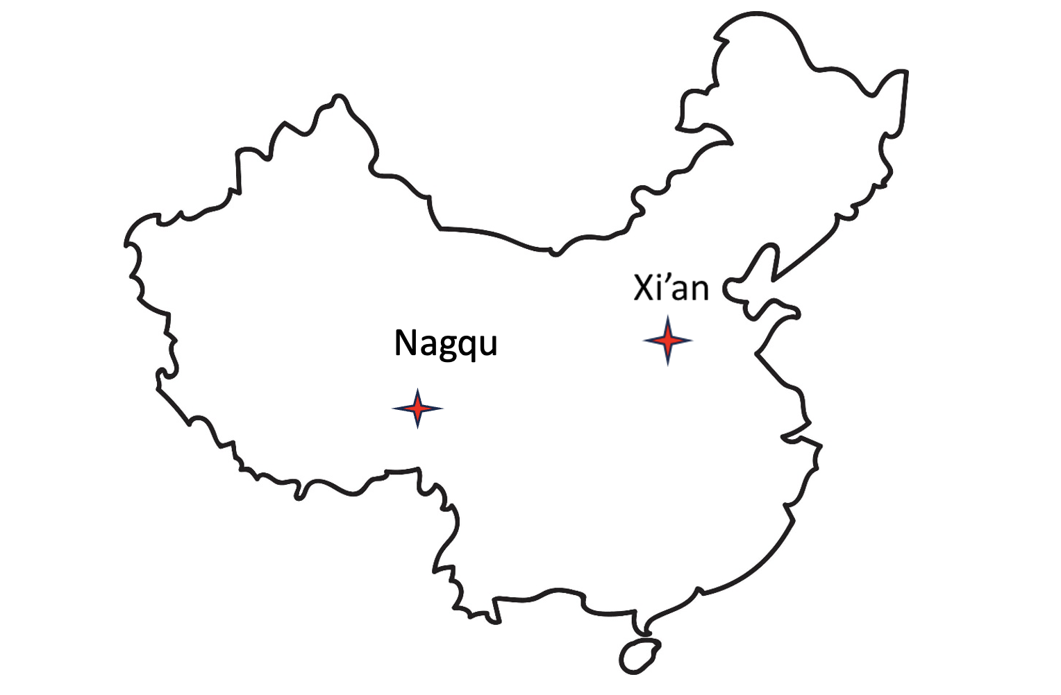
On May 21 this year, a government affairs article in Shaanxi’s “The Paper” announced accelerated construction in Xi’an of a science center. Its centerpiece will be the country’s High-precision Ground-based Timing System. It is not entirely clear from the article whether this site will be the engineering and administrative headquarters for the system, or one of several “timing stations.”
The article also says the national system will be the largest in the world — with more than 20,000 kilometers of optical fiber and 295 time and frequency transmission sites — and will integrate space- and ground-based signals.
The network, according to the article, will supplement and improve the new eLoran (sometimes mistranslated by software as “Roland”) system in the western portion of the country. It will also support legacy eLoran “long-wave” signals in the east ensuring that the entire nation is well served.
Graphic from 2014 Chinese Academy of Sciences paper on Laron showing projected coverage in the western part of the country. Subsequent papers and announcements have indicated that western part of the network is complete or soon will be. (Image: Chinese Academy of Sciences)
Accuracy for the system’s fiber-optic transmissions is claimed to be less than 100 pico-seconds, with differential eLoran at less than 100 nanoseconds.
Construction recently announced in Xi’an and Nagqu as part of China’s High-precision Ground-based Timing System.
A much shorter press release was issued on June 8, announcing groundbreaking for a “timing station” in Nagqu on the Tibetan plateau in China’s west. The announcement said that, once the station was complete, China will “…realize national soil coverage of long-wave [eLoran] timing signals…”
Expansion of its eLoran and fiber infrastructure to serve the entire nation gives China what some have called the “PNT resilience triad” — signals from space, from terrestrial broadcast, and over fiber. The three sources of delivery are sufficiently different that an accidental or malicious disruption of one is highly unlikely to impact the other ones. Users accessing all three should experience minimal to no impact.
Both the May and June announcements said that finishing the timing project will benefit China’s national economy and national security.
Timing is essential tech infrastructure. More precise and robust timing enables improvements to current applications and the creation of new ones. For example, better timing can enable greater spectrum efficiency with more throughput on existing frequency bands. Highly precise fiber-based timing could also support using 5G telecommunications networks for hyper-precise positioning in autonomy corridors serving self-driving vehicles, UAVs, and other systems.
China’s ground-based timing system is part of a larger plan by its National Timing Service Center for a system of systems approach to PNT. Described as a “comprehensive approach” at the Standford PNT Symposium in 2019, the architecture has satellite-based navigation at its heart and includes a wide variety of other capabilities.
Graphic showing China’s plan for multiple, mutually supporting, diverse methods of positioning, navigation, and timing service and data. (Presentation by China’s National Time Service Center at 2019 Standford PNT Symposium)
Some observers trace China’s national PNT efforts to an incident in 1996 during the Third Taiwan Strait Crisis. Chinese forces fired three missiles toward a point in the sea offshore of Tiawan’s Kee Lung naval base. Two of the missiles were lost. According to the People’s Liberation Army this was because the United States denied or altered GPS signals that the missiles were using for guidance.
Known by China’s military as “The Unforgettable Humiliation” the incident sparked decades of effort to ensure China would never again be dependent upon another nation or space for PNT. The BeiDou global navigation satellite system and the High-precision Gound-based Timing System are the two most noteworthy accomplishments in this regard.
Implications for the United States
China’s ever-increasing lead in essential PNT technology and infrastructure is of great concern to many in the United States.
China’s global navigation satellite system, Bei Dou, is newer and, according to a presidential advisory board, substantially superior to GPS in many ways. Using it as an instrument of “soft power,” China is offering other nations BeiDou signals, along with discounted user and support equipment, as part of its Belt and Road, and Digital Silk Road initiatives. Where successful, these efforts erode both GPS usage and U.S. influence.
Of greater concern to many are the “hard power” implications of China’s PNT dominance.
While China has and continues to develop multiple and resilient sources of PNT, in the United States “GPS is still a single point of failure,” according to a member of the National Security Council.
As a result, if China were to interfere with GPS in some way, a U.S. response in-kind against BeiDou would have much less impact. This strategic asymmetry has been described by former CIA senior analyst George Beebe as “an open invitation” for mischief or attack. One that could easily lead to an escalating series of responses ending in an armed conflict no one wants.
At a more tactical level, China’s eLoran system extends 1,000 miles offshore covering Taiwan, the Strait, and all approaches. In a conflict to capture the island and make it subject to the Communist regime, China could block all signals from space while preserving its forces’ ability to maneuver and communicate. Already at a disadvantage having to deploy far from their support bases, this would further hamper U.S., Japanese, and other forces hoping to help Taiwan maintain its independence.
The U.S. Department of Defense boasts it can operate well in GPS-denied environments and says it is also working on alternative means of navigation for deployed forces.
This begs the strategic question, though, of whether the United States would be willing to come to the aid of Taiwan or another ally if the homeland were threatened with a prolonged and crippling disruption of GPS services.
Prior to Russia’s invasion of Ukraine, the Kremlin destroyed a defunct satellite and boasted it would shoot down all 32 GPS satellites and “blind NATO” if the alliance intervened. Many observers have wondered whether that has played into subsequent U.S. and NATO policy toward the conflict.
Unfortunately, little has been done to eliminate the possibility of a belligerent adversary holding the U.S. homeland hostage through GPS.
For two decades narrow government and industry interests in GPS production have successfully opposed any effort they see as possibly “competing” for space in limited budgets. Appeals that such projects would increase system security by “taking the bullseye off” GPS satellites and signals have been to no avail.
However, this may be changing. Several years ago the National Guard began development of a national timing architecture and network, called NITRO. The project supports the Guard’s own requirements to be able to operate without GPS and to aid state first responders. It is already in use in 7 states.
The future of NITRO is unclear, though, as the Department of Defense sees it as a civil defense rather than a national defense project and is no longer supporting it in the budget. Yet, the National Guard’s funding flows through defense appropriations.
As of this writing, the National Guard and NITRO remain stuck in a bureaucratic and budgetary no-man’s land with no clear path forward.
An exclusive interview with Julian Thomas, managing director, Racelogic. For more exclusive interviews from this cover story, click here.
In which markets and/or applications do you specialize?
We originally designed our LabSat simulator for ourselves, because we supply GPS equipment to the automotive market. Then, we decided to sell it into that market, which is our primary market, for other people to use. That’s where we started, but it has moved on since then. We supply many of the automotive companies who use it for testing their in-car GPS-based navigation systems.
However, we’ve moved on to our second biggest market, which is the companies that make deployment systems for internet satellites, which use it for end-of-life testing. Several of our customers use it. That’s because we do space simulations, so we can simulate the orbits of satellites. That’s very useful when they’re developing their satellites.
We supply many of the major GPS board manufacturers — such as NovAtel, Garmin, and Trimble — when they’re developing their boards and testing their devices. We supply many of the phone companies — such as Apple and Samsung — and many of the GPS chip manufacturers — such as Qualcomm, Broadcom, and Unicom. More or less any company that’s into GNSS.
How has the need for simulation changed in the past five years, with the completion of the BeiDou and Galileo GNSS constellations, the rise in jamming and spoofing threats, the sharp increase in corrections services, and the advent of new LEO-based PNT services?
It all started off very simple, with just GPS, which was one signal and one frequency. We got that up and working very well and it helped us a lot. Then we got into this market. In the last few years, we’ve had to suddenly invent 15 new signals. We do two systems, really: one is a record-and-replay system. You put a box in a car, on a bike, in a backpack, or on a rocket, and you record the raw GPS signals; then you can replay those on the bench. That requires greater bandwidth, greater bit depth, smaller size, battery power, all of that.
The other is pure signal simulation. We simulate the signals coming from the satellites from pure principles. So, we’ve had to dive into how those signals are structured, reproduce them mathematically, and then incorporate that in into our software. That’s been 15 times the original work we thought it would be, but as we add each signal it tends to get a bit simpler until they add new ways to encode signals, and then it gets complex again. We’ve had to increase our bandwidth, increase our bit depth for the recording to cover all of these new signals.
Because our systems record and replay, they’re used a lot to record real-world jamming. In many scenarios, our customers will take one of our boxes into the field and record either deliberate jamming or jamming that’s been carried out by a third party. Then they can replay that in the comfort of their lab.
With regards to spoofing, we’ve just improved our signal simulation. So, we can completely synchronize it with real time. We can do seamless takeover of a GNSS signal in real time. We can reproduce the current ephemeris and almanac. If we transmit a sufficiently powerful signal, we can completely take over that device. Then we can insert a new trajectory into it. That’s a very recent update we’ve done.
If the complexity and amount of your work has gone up so much in the last few years but you cannot increase your prices at the same rate, what does that do to your business model?
It’s the same people that produce the signals in the first place, so they still have a job. However, as we add more signals and capabilities, we tend to get more customers as well.
Oh, so, you’re expanding your market!
Right, right.
Regarding some of the new PNT services being developed, how do you simulate them realistically without the benefit of recordings of live sky signals?
It is all pure signals simulation. You go through the ICD line-by-line and work out the new schemes. Here’s an interesting anecdote. Our developer who does a lot of the signal development is Polish and is also fluent in Russian. When we were developing the GLONASS signals, he was working from the English version of the GLONASS ICD. He said that it didn’t make any sense. So, he looked at the Russian version and discovered that the English one had a typo. When he used the Russian version, everything worked perfectly. He told this to his contacts at GLONASS and they thanked him and updated the English translation of their document. So, you are very, very much reliant on every single word in that ICD.
Are there typically differences between the published ICD and the actual signal?
No, no. Apart from the Russian one, which had a typo, they’re very good. For example, we’ve recently implemented the latest GPS L1C signal. My developer spent six months recreating it and getting all the maths right and the only way you could test it was to connect it to a receiver and hit “go.” It just worked the first time. He almost fell off his chair. The ICD in that case was very, very accurate.
Hope that Xona’s ICD is just as good.
Yeah.
Are accuracy requirements for simulation increasing, to enable emerging applications?
Yes, absolutely. No one can have too much accuracy. Everyone’s chasing the goal of getting smaller, faster, and more accurate systems. They want greater precision and better accuracy from their simulators, as well as a faster response. We do real-time simulators and they want a smaller and smaller delay from when you input the trajectory to when you get the output. Luckily for us, Moore’s law is still in effect, so, as the complexity of the signals and the accuracy requirements increase, computers can churn through more data. Luckily, we’re able to keep up on the hardware side as well, because much of our processing is done using software. Some companies do it in hardware and some companies do it in software. We concentrate on the software side of things.
Here’s another interesting anecdote from my Polish guy. He noticed that the latest Intel chips contain an instruction that multiplies and divides at the same time but that it wasn’t available in Windows. So, he put in a request with Microsoft for that operational code and they incorporated it into the very latest version of dotnet, which has improved our simulation time by 7%. I see little improvements like that all the time.
Are all your simulators for use in the lab or are some for use in the field? If the latter, for what applications and how do they differ from the ones in the lab? (Well, for starters, I assume that they are smaller, lighter, and less power-hungry…)
All our systems are designed to be used inside and outside the lab. They can all be carried in a backpack, on a push bike, in a car. We do that deliberately, because we come from the automotive side of things, so we have to keep everything very small and compact.
Besides automotive, what are some field uses?
Some of our customers have put them in rockets, recording the signal as it goes up, or in boats. We have people walking around with an antenna on their wrist connected to one of our systems, so that they can simulate smartwatches. There are many portable applications. We have a very small battery-powered version, which makes it very independent.
Are there any recent success stories that you are at liberty to discuss?
Our most exciting one is a seamless transition for simulation that we developed to replace or augment GPS in tunnels. We’ve been talking to many cities around the world that are building new tunnels. Because modern cars automatically call emergency services when they crash or deploy their airbags, they need to know where they are, of course. Cities need to take this into account when they are building new tunnels, which can pass over each other or match the routes of surface streets. Therefore, accurate 3D positioning in the tunnels has become essential. It requires installing repeaters every 30 meters along each tunnel and software that runs on a server and seamlessly updates your position every 30 meters. As you enter a tunnel, your phone or car navigation system instantly switches to this system. It’s been received very well because it’s mainly software and the hardware is pretty simple. We’ve brought the cost down to a fifth of the cost of standard GPS simulators for tunnels. So, we’re talking to several cities about some very long tunnels, which is very exciting.