Category: Galileo

  • Random recollections of GPS/GNSS

    Random recollections of GPS/GNSS

    2000: An Allstar OEM receiver. (Photo: NovAtel)
    2000: An Allstar OEM receiver. (Photo: NovAtel)

    GPS had been around for about five years before first launch in February 1978 and Full Operational Capability (FOC) was eventually declared in April 1995. It takes time to develop, field and prove something as complex as the world’s first satellite navigation system. But we’re now well into a third generation of the venerable GPS, with GLONASS, Galileo, BeiDou and IRNSS/NavIC and QZSS around the world and in geographic locales. So, putting aside Transit or anything else, this would make GPS about 47 years old — heading into middle age.

    Therefore, it would seem that Glen Gibbons waited until “this GPS thingy” looked like it might actually work — circa 1990 — to launch GPS World, since the magazine is now 30 years old and is also into its third-generation of editor-custodians! Alan Cameron bravely carried the flag after Glen and nurtured the magazine for a good number of years and brought me into the fold as a contributor. We shared ION GNSS conventions and GPS World Leadership dinners and he was able to cajole monthly articles out of me for many years. Now Marty Whitford has his hand firmly on the tiller as publisher, with Tracy Cozzens as senior editor.

    So what went down during these decades of technological advancement and for many of the people in the satnav industry? It would be impossible to answer within my word-limit, so I’ll take on an extremely small subset and recount a few things I can still remember.

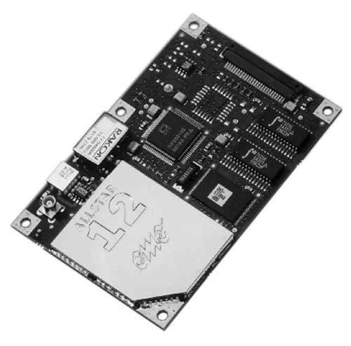
    µGPS. I got into GPS around 1990 in an OEM board-level product spin-off program from a certified GPS airborne receiver at CMC in Montreal — we initally called that L1 receiver µGPS because then it was a small GPS board. Later it became known as the AllStar receiver. We found pretty neat applications for the early ’90s — golf-course systems, vehicle tracking, airport vehicle tracking, the start of vehicle nav systems and such.

    At NovAtel in Calgary in the early ’90s, we watched things develop through L1/L2 dual frequency, began RTK market applications in survey, geographic information systems (GIS), agriculture, mining and all multitudes of attempts to get new companies off the ground.

    2013: NovAtel’s WAAS G-II reference receiver. (Photo: NovAtel)
    2013: NovAtel’s WAAS G-II reference receiver. (Photo: NovAtel)

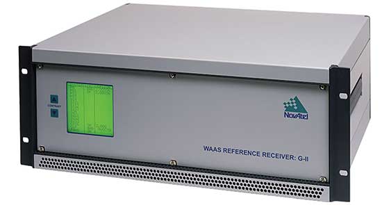
    WAAS. Eventually the U.S. Wide-Area Augmentation System (WAAS) program came and swallowed us up through three different prime contractors. Once that Federal Aviation Administration program was running well, we were into programs in Europe, Japan, India and China, and that led into Galileo ground reference receivers. The software qualification work we did on Galileo positioned us to take on mil-spec receiver work, and even anti-jam products.

    Then CMC bought NovAtel, and we also joined with CMC to develop a certified airborne receiver. In 2003, NovAtel bought the AllStar OEM product line from CMC — funny how things work out! The joint certified receiver program eventually resulted in a new generation of high-accuracy airborne sensors. We again changed hands in 2007 when Hexagon bought us, and then NovAtel began working closely with Hexagon subsidiary Leica on survey applications. Many new and interesting developments are still going on there.

    Nowadays, my interests lie with assisted GNSS and with Rx Networks in Vancouver, which I support and advise. Assisted GNSS comes in many forms, has many avenues in the marketplace, and presents its own unique challenges.

    As GPS has evolved into GNSS and into so many, many applications, companies have come and gone but the core of people who drive the industry has grown and acquired new and specialized skills, developing ever more capable technology and products. Even after 47 years of the industry and 30 years of GPS World, we aren’t anywhere close to done.

  • GSA and CLGE accepting submissions for Geomatics on the Move 2020 competition

    GSA and CLGE accepting submissions for Geomatics on the Move 2020 competition

    Logo: Geomatics on the Move competition

    The European GNSS Agency (GSA), in collaboration with the Council of European Geodetic Surveyors (CLGE), has launched the Geomatics on the Move 2020 competition. The event aims to foster the use of European Union (EU) satellite programs Galileo, EGNOS and Copernicus among students, young professionals, entrepreneurs and small and mid-sized businesses to create innovative geomatics applications and solutions across all over Europe.

    Building and expanding on the CLGE Student Contest, which has been held for the past nine years, the new Geomatics on the Move Prize Contest targets applications that integrate the use of additional technologies such as artificial intelligence, machine learning, augmented and virtual reality, as well as supplementary remote sensing data sources like drones, GSA said. Solutions animated through mobile phone applications or other easy-to-use platforms are also accepted.

    “This is the ninth year of partnership between the Council of European Geodetic Surveyors and the GSA; over the years we have seen some exciting and innovative solutions emerge that leverage the EU Space Programme to deliver practical solutions for the mapping and surveying community,” said GSA Acting Executive Director Pascal Claudel. “This year, as we recover from this global setback, I look forward to seeing even more novel ideas — from all over the European Union — able to respond to current and future challenges.”

    The competition will be organized in two stages. The first phase is an open call for ideas, during which applicants submit posters describing their ideas. The deadline for these submissions is Oct. 16.

    The proposals then will be evaluated by the GSA and CLGE, and a maximum of 10 projects will be chosen to present their pitch during the finals. The selected applicants will refine their poster and prepare their pitch, for which technical support and training will be made available.

    The official award of the Geomatics on the Move prize contest will take place virtually, during the European Space Week, taking place Dec. 7-11. During this event, finalists will present their solutions to the evaluation board, and winners will be announced on the official contest site.

    With an overall prize of €30 000, a set of 10 prizes will be offered in two categories. The first of these categories targets EU space-based traditional geomatics solutions and the second targets integrated geomatics solutions. he first category is looking for solutions in which the main innovation is based on the use of EGNSS, employing traditional equipment such as surveying or GIS grade GNSS receivers for applications such as cadastral, marine and mining surveying or GIS mapping. The integrated geomatics category targets integrated surveying solutions that use Galileo or EGNOS and leverage cutting-edge tools and technologies such as drones, mobile mapping, laser scanners or augmented/,mixed reality, both within geomatics applications or beyond.

  • FCC grants E9-1-1 Galileo request to AT&T

    FCC grants E9-1-1 Galileo request to AT&T

    AT&T logoOn Aug. 19, the U.S. Federal Communications Commission (FCC) granted a request for authorization from AT&T Services to use Galileo for emergency location purposes.

    AT&T plans to use Galileo in conjunction with GPS to improve the accuracy of its E9-1-1 location services on mobile devices, and facilitate faster response from emergency services when wireless callers dial 9-1-1.

    The request was approved by the FCC’s Public Safety and Homeland Security Bureau .

    The FCC found that AT&T had satisfied the conditions for commercial mobile radio service (CMRS) providers to integrate foreign satellite signals into E9-1-1 services.

    Under E9-1-1 requirements established in 2015, CMRS providers seeking to use foreign signals for E9-1-1 services must meet several conditions, including ensuring that integrating non-U.S. signals won’t cause interference with the E9-1-1 system.

    Carriers also need to submit a signal integration plan including a mechanism to detect, mitigate and disable Galileo signals if they cause harmful interference.

    Read the order here.

  • MyGalileoDrone competition seeks UAV innovations

    MyGalileoDrone competition seeks UAV innovations

    The European GNSS Agency (GSA) has launched the MyGalileoDrone competition.

    The contest targets the design and development of drone-based applications or services, using a Galileo-enabled receiver, to address the European Union’s (EU’s) key priorities such as the Green Deal, and support the EU Recovery Plan for Europe.

    Initial ideas should be submitted by Aug. 31. Wide participation from all EU Member States is expected.

    According to ESA, the MyGalileoDrone competition seeks to tap into the EU’s innovative spirit to deliver applications and services to boost Europe’s competitiveness, resilience and sustainability. Applications should leverage and demonstrate Galileo’s added value, such as increased accuracy, availability and robustness of position, as well as integrity for a solution based on drone operations.

    Drones applications

    Photo: © GSA
    Photo: ©GSA

    The market related to drone applications and services is growing rapidly, and European drone service revenues are expected to reach EUR 250 million by 2025. The European demand is estimated to reach EUR 10 billion annually, in nominal terms, to 2035 and over EUR 15 billion annually to 2050, creating more than 100,000 jobs.

    With GNSS receivers implemented on almost all new commercial drones, Galileo’s and EGNOS’ added value is pivotal for the development and growth of drone services and applications.
    In addition to designing and developing the application, contestants should prepare their drone- based application or service for commercial launch.

    The solution should leverage Galileo to provide a position fix. The use of EGNSS is understood in the broad sense, and Galileo can be integrated in the flying platform, the ground control station, or in other devices supporting the operation, such as a smartphone or even in the frame of U-Space services.

    “GNSS is a key enabling technology in this segment, ensuring robust navigation and reliability for a wide range of applications. The MyGalileoDrone competition aims to bring oxygen to European SMEs and entrepreneurs driving innovation. It will create jobs and growth in this promising market,” said Pascal Claudel, acting executive director at the GSA.

    Focus on EU priorities

    In times of post-COVID recovery focus, submissions should target applications and services that support key EU priorities, but the sky’s the limit. The GSA is looking for trailblazing ideas in applications such as smart mobility, sustainable agriculture or environmental protection, or solutions that exploit synergies between 5G and space data, or support the internet of things, or whatever might be the next big thing.

    Deadlines and Prizes

    The first prize in the MyGalileoDrone competition amounts to EUR 100,000, with EUR 60,000 for second, EUR 40,000 for third, and a fourth prize of EUR 30,000.

    After Aug. 31, projects selected to advance to the development phase of the contest will be announced on Sept. 15. Participants will  have until Nov. 30 to develop a demo version of their proposed application or service.

    In the finals, the selected teams will perform a live demonstration and pitch their ideas to investors. During the development process, the applicants will receive mentoring and coaching from recognized experts in the drone market. These experts will accompany them as they build their application, develop tests and get ready from the business perspective to attract investors and move to market.

    To register or for more information, visit the competition page on the GSA website.

  • Galileo-enabled receivers are increasing positioning

    Galileo-enabled receivers are increasing positioning

    Photo: Philipp Berezhnoy/iStock / Getty Images Plus/Getty Images
    Photo: Philipp Berezhnoy/iStock / Getty Images Plus/Getty Images

    Access to the Galileo signal in a multi-constellation environment is providing benefits and opportunities for businesses, thanks to the enhanced performance and increased accuracy on offer, said the European GNSS Agency (GSA).

    Swedish geographical information technology company SCIOR Geomanagement AB uses a variety of technology in its equipment, including drone aerial photography, terrestrial laser scanning, GNSS or combinations of these.

    SCIOR, a measurement technology producer, incorporates RTK processing techniques into its approach. The company also uses Galileo-enabled receivers to increase the positioning accuracy of its solutions.

    According to the company’s findings, which it presented at the 2019 Intergeo conference in Stuttgart, it has been achieving significantly enhanced performance and other benefits in its day-to-day activities from the use of Galileo-enabled equipment, GSA said.

    “Our experience with Galileo has shown an improvement in the density of the constellation of visible satellites, and thus an improvement in the time needed to obtain centimeter-level accuracy,” said Javier Corral, an engineer at SCIOR Geomanagement AB. “From my personal point of view, I would recommend using this constellation in combination with the other existing ones, since it provides you with a better and quicker performance.”

    According to GSA, the most significant performance improvements are observed at high latitudes and within forest environments. Even taking into account that better results can be obtained in open spaces, using multi-constellation GNSS with Galileo in the woods is sometimes the only way to obtain a satisfactory performance if there is no reference station close enough. performance will be even better in coming years as the number of Galileo satellites increases to reach full operation capability, allowing users to obtain their desired position accuracy and availability in a shorter period of time, GSA added.

  • Galileo positioning aids with COVID-19 tracking apps

    Galileo positioning aids with COVID-19 tracking apps

    Image: ESA
    An artist’s rendering of a Galileo satellite in orbit (Image: ESA)

    News from the European Space Agency

    As European governments plan their phased recoveries from the lockdown states triggered by the COVID-19 pandemic, the positioning delivered through satellite navigation is becoming more important than ever before, said the European Space Agency (ESA). Location is a key requirement when attempting to monitor and map the spread of a disease and satnav is one of the main tools supporting this, the agency added.

    Since the outbreak of the coronavirus, many applications have been developed that use satnav-based location data to monitor the global spread of the virus and map outbreaks.

    For example, Romanian company RISE developed an app called CovTrack, which monitors people in a user’s vicinity made identifiable via Bluetooth connections to the user’s mobile phone and stores the identification data of these devices.

    By pressing a button, users can access the database in which the unique identifiers of the mobile phones are registered (without having access to any personal data of these mobile phone users), to verify whether the persons with whom users came in contact have subsequently been confirmed with COVID-19, ESA said. If users have identified a potential contact, they can refer to the relevant authorities whether that contact requires inclusion among the monitored persons, or even testing for COVID-19.

    According to ESA, CovTrack, developed on a pro-bono basis, is a spin-off from the existing AGORA project for festival management, supported through ESA’s Navigation Innovation and Support Programme, focused on future navigation technologies.

    ESA, along with the European Global Navigation Satellite System Agency (GSA) and European Commission, put together a repository of these apps. The list, based on apps that are already working and available in app stores, includes practical apps that facilitate the daily lives of citizens. Check out the list here.

    Europe’s Galileo, currently embedded in over 1.3 billion smartphones and devices worldwide, is helping to increase satnav accuracy and availability, especially in urban areas, ESA added.

    In addition, GSA is developing its own Galileo-enabled application, Galileo for Green Lane, to monitor and ease the circulation of goods between European Union (EU) Member States while identifying potential congestion at Green Lane border crossings, thus ensuring EU citizens can access the needed supplies of critical goods.


    Check out more of GPS World’s coronavirus coverage here.

  • SUGUS project launches survey for drone users, GNSS communities

    SUGUS project launches survey for drone users, GNSS communities

    Image: Tanaonte / iStock / Getty Images Plus / Getty Images
    Image: Tanaonte / iStock / Getty Images Plus / Getty Images

    SUGUS — a European Commission project to promote European GNSS services for the integration of drones into the airspace — is conducting an online survey of stakeholders.

    SUGUS, the European Commission’s project for the development of European GNSS (Galileo and EGNOS) services for U-space, is carrying out a survey to identify, gather and understand stakeholders’ needs, and to improve user experience of E-GNSS in complex operations and built-up areas.

    U-space is a set of new services and specific procedures designed to support safe, efficient and secure access to European airspace for large numbers of drones.

    SUGUS members invite all the stakeholders to take part in the survey, including suppliers of U-space services, manufacturers of unmanned aerial systems (UAS) platforms and GNSS receivers, UAS pilots and operators, public bodies, authorities and organizations, and centers for UAS testing and training.

    The survey will be available until May 15.

    The survey results will be used as a valuable input to tailor the E-GNSS Service Provision layer to specific drone missions’ needs, allowing a better mitigation of risks in complex operations like BVLOS (beyond visual line of sight) and UAM (urban air mobility), increasing safety and security.

    Also, the points of view collected will help to define the requirements and then the implementation of a new E-GNSS-based API which will deliver live and forecast information about performance, coverage, alerts to users and more.

    The API will be called upon by UTM service providers, UAS designers or UAS systems developers, and integrated in existing commercial solutions.

    “The survey organized by SUGUS is a key element for E-GNSS Programs to capture user requirements of the drone community,” explained Miguel Aguilera, European Commission advisor. “The results will be used to enhance EGNOS and Galileo Service Provision targeting drone operations, increasing safety and security, and facilitating a swift and efficient deployment of U-space.”

    SUGUS Project

    SUGUS (Solution for E-GNSS U-Space Service) is a European Commission’s project to promote European GNSS services (EGNOS and Galileo) for the drone market and for the effective and safe integration of these aerial platforms in the airspace.

    It is a European Union H2020 R&D project to be carried out by GMV (main contractor) with everis Aerospace, Defense and Security as co-leaders of a consortium also involving VVA Brussels, ESSP, FADA-CATEC and Unifly.

    SUGUS will help to develop services geared towards the effective integration of drones into the airspace. A series of trials will be held to show the benefits of E-GNSS for drone operators, as well as its approval by aviation authorities.

  • Galileo Masters 2020 open for submissions

    Galileo Masters 2020 open for submissions

    Photo: voyata/iStock / Getty Images Plus/Getty Images
    Photo: voyata/iStock / Getty Images Plus/Getty Images

    The 2020 Galileo Masters are open for submissions. The competition is designed to award applications, services and new ideas that use Galileo and EGNOS, in synergy with other space programs, to respond to pressing needs facing business and society.

    The 2020 competition has three European GNSS Agency (GSA) challenges, themed “Space for Future Generations.”

    The first challenge, the “Space for our Planet Challenge,” aims to tackle climate change and environmental degradation. Services based on data from Galileo, EGNOS and Copernicus Earth observation can be used to mitigate this threat by supporting more environmentally-conscious life choices, resulting in a healthier planet, GSA said.

    The second challenge, the “Space for Being Safe and Healthy Challenge,” seeks out solutions that use downstream space data provided by Galileo, EGNOS and/or Copernicus as key enablers of innovative applications to help stem the spread of COVID-19 pandemic.

    The third challenge, the “Space for Fun Challenge,” targets solutions using data from Galileo and EGNOS in the gaming, sports, leisure and tourism markets, where GNSS enables the monitoring of user performance and helps make augmented reality games even more immersive.

    For all three challenges, there is a cash price of 10,000€, with another 10,000€ awarded to the overall Galileo Masters 2020 winner.

    Registration is free, and entries must be submitted by June 30.

  • Skycatch system provides in-the-field UAV maps

    The Edge1 system by Skycatch is a combination GNSS base station and drone data-processing unit that delivers high-accuracy maps and point clouds in minutes.

    The high-performance built-in Nvidia TX2 Mobile GPU enables both maps and point-cloud processing locally within 30 minutes, as well as running artificial intelligence (AI) tasks in real time.

    The base station of the Edge1 uses a Swift Navigation dual-frequency GNSS real-time kinematic (RTK) receiver. The receiver supports signals from GPS, GLONASS, BeiDou and Galileo, enabling reliably fast centimeter-level accuracy globally even in remote locations, with reliable 5-centimeter accuracy.

    Users of the Edge1 system can process and receive their maps in the field, without the need for internet connectivity to process data. The system automatically generates 2D maps and 3D data, with the capability to download and use them in Skycatch’s Data Hub, as well as commonly used programs like Civil 3D, BIM360 and others.

  • Testing suspended on Galileo Batch 3 satellites

    Testing suspended on Galileo Batch 3 satellites

    In response to the ongoing coronavirus pandemic, the test campaign for the first two satellites of Galileo’s Batch 3 has been suspended.

    The suspension is based on the medical advice for social distancing — too high a concentration of people is needed on site if testing were to continue, according to the European Space Agency (ESA).

    An aerial view of ESTEC. The Erasmus building is at front right. The T building (home to ESA's Galileo team) is in the foreground. (Photo: ESTEC)
    An aerial view of ESTEC. The Erasmus building is at front right. The T building (home to ESA’s Galileo team) is in the foreground. (Photo: ESTEC)

    The satellites are based at the ESTEC Test Centre in the Netherlands for engineering tests ahead of launch. The stored satellites are being monitored by staff visiting ESTEC every few days, to verify that all is in order.

    Other Galileo-related testing continues with the aim of supporting future launches. ESTEC-based lifetime testing of the next set of rubidium atomic clocks is set to continue, involving on-site monitoring every few days.

    Working from home

    ESA’s Directorate of Navigation has shifted to teleworking while also ensuring the continuity of essential tasks, in particular the continued delivery of positioning, navigation and timing services of both Galileo and EGNOS.

    The ESA team is using video and audio conferences to continue meetings with the industries involved and minimize the impact on the deliveries of EGNOS upgrades, Galileo Batch 3 satellites, and preparatory work for Galileo Second Generation.

    The national, local and industrial decisions on travel, meetings and quarantine are impacting the ability to deliver all ongoing commitments, so measures are being taken to minimize their impact, ESA said in a press release.

    Priority has been given to ensure continued operations of both EGNOS and Galileo, so the ESA Navigation Directorate has been supporting the European GNSS Agency (GSA), the operator of Galileo and EGNOS, on behalf of the European Commission.

    The team also is maintaining constant contact with various stakeholders.

    NAVISP and Horizon 2020

    Research and development projects under the Directorate’s Navigation Innovation and Support Programme (NAVISP) are continuing at a somewhat slower pace, given the crisis. So are satellite navigation projects financed by the EU’s Horizon 2020 programme, which develop future technology for the EU satellite navigation projects.

    “Confronted with this unprecedented situation, our efforts are focussing on business continuity and supporting the GSA with services provision of Galileo and EGNOS, while taking all necessary measures to protect our personnel,” said Paul Verhoef, ESA Director of Navigation. “An impact assessment will only be possible when we see the end of the restrictions in the various European countries. For the time being, stay home, stay healthy, is the priority, whereas however we are in close contact with industry to try and keep momentum on the projects that are underway.”

  • Galileo now replying to SOS messages worldwide

    Galileo now replying to SOS messages worldwide

    News from the European Space Agency

    As well as providing global navigation services, Europe’s Galileo satellite constellation is contributing to saving more than 2,000 lives annually by relaying SOS messages to first responders. And from now on the satellites will reply to these messages, assuring people in danger that help is on the way.

    This ESA-design return link system, unique to Galileo, was declared operational this week, during the 12th European Space Conference in Belgium. The delivery time for the return link acknowledgement messages from initial emergency beacon activation is expected to be a couple of minutes in the majority of cases, up to 30 minutes maximum, depending primarily on the time it takes to detect and locate the alert.

    Cospas-Sarsat rescue beacon activated. Its signals are picked up by satellites in orbit, including Galileo. (Photo: GSA)
    Cospas-Sarsat rescue beacon activated. Its signals are picked up by satellites in orbit, including Galileo. (Photo: GSA)

    “Anyone in trouble will now receive solid confirmation, through an indication on their activated beacon, informing them that search and rescue services have been informed of their alert and location,” explains ESA’s Galileo principal search and rescue engineer Igor Stojkovic. “For anyone in a tough situation, such knowledge could make a big difference.”

    All but the first two out of 26 Galileo satellites carry a Cospas-Sarsat search and rescue package. At only 8 kg in mass, these life-saving payloads consume just 3 percent of onboard power, with their receive-transmit repeater housed next to the main navigation antenna.

    Image: ESAPhoto:
    Image: ESA

    Founded by Canada, France, Russia and the US in 1979, Cospas-Sarsat began with payloads on low-orbiting satellites, whose rapid orbital motion allows Doppler ranging of distress signals, to pinpoint their location. The drawback is these fly so close to Earth that their field of view is comparatively small.

    Geostationary satellites went on to host Cospas-Sarsat payloads. These see much more of the planet, but because they are motionless relative to Earth’s surface, Doppler ranging is not possible.

    Medium-orbiting satellites such as Galileo – orbiting at 23 222 km altitude – offer the best of both worlds, providing a wide ground view by multiple satellites combined with time-of-arrival and Doppler ranging techniques to localise SOS signals. This improves the maximum signal detection time from four hours to less than five minutes, down to one or two kilometres (within a formal specification of 5 km within 10 minutes).

    Galileo’s Search and Rescue service is Europe’s contribution to Cospas-Sarsat, operated by the European Global Navigation Satellite System Agency, GSA, and designed and developed at ESA. As the overall Galileo system architect and design authority, ESA has been responsible for the interface between the core Galileo infrastructure to the Return Link Service Provider facility, procured by the European Commission and operated by French space agency CNES.

    The Cospas-Sarsat satellite repeaters are supplemented by a trio of ground stations at the corners of Europe, known as Medium-Earth Orbit Local User Terminals (MEOLUTs), based in Norway’s Spitsbergen Islands, Cyprus and Spain’s Canary Islands and coordinated from a control centre in Toulouse, France. This trio is soon to become a quartet, with a fourth station on France’s La Reunion Island in the Indian Ocean under development.

    The satellites relay distress messages to these MEOLUTs, which then relay them to local search and rescue authorities.

    a public demonstration of Galileo's return link service was performed at the Cospas-Sarsat Joint Committee Meeting in Doha in Qatar in summer 2019. ()Photo: ESA)
    A public demonstration of Galileo’s return link service was performed at the Cospas-Sarsat Joint Committee Meeting in Doha in Qatar in summer 2019. ()Photo: ESA)

    The service’s return link message capability was developed as an inherent part of the Galileo system. The messages are relayed to the individual beacons that sent the original distress call by being embedded within Galileo signals broadcast from satellites in their view.

    “The switching on of the return link service was enabled by a thorough test campaign carried out by ESA, with the support of the GSA and CNES,” adds Igor. “We needed to be sure the service remains reliable even with multiple distress calls being replied to at once.”

    A key milestone was a public demonstration of the return link service, performed at the Cospas-Sarsat Joint Committee Meeting in Doha in Qatar last summer.

    “The return link is a joint service of Cospas-Sarsat and Galileo and therefore agreement by Cospas-Sarsat was crucial,” adds Igor.

    “This acceptance was achieved through long discussions led by the European Commission at the Cospas-Sarsat Council last November, supported by plentiful documentation of simulations and test results provided by ESA and CNES.”

  • NeQuick G code available for download

    NeQuick G code available for download

    Global ionospheric map calculated with NeQuick G for the 18 09 2019 at 07 UT (DOY 261, 2019)I (Image: GSA)
    Global ionospheric map calculated with NeQuick G for the 18 09 2019 at 07 UT (DOY 261, 2019). (Image: GSA)

    News from the European GNSS Agency (GSA)

    A version of the NeQuick G algorithm using a new coding approach is now available for download on the GSC website. This version is the result of intensive recoding by engineers at the EU’s Joint Research Centre.

    GNSS signals traveling through the ionosphere can be significantly delayed by the electrical charges in this atmospheric layer before reaching the users’ terminal. To compensate for this delay in the signal, Galileo receivers integrate a dynamic model of the ionosphere composition known as the NeQuick G model.

    Receiver manufacturers will now be able to benefit from a version of the NeQuick G correction algorithm that implements a new coding approach.

    Rigorous testing

    The JRC concluded its work recently after successful rigorous testing in the framework of the gLAB tool (GNSS software suite from the Universitat Politecnica de Catalunya). This version of the code has been designed to be highly modular, rendering it more legible for a potential programmer with no specific knowledge about signal propagation in the ionosphere. A library has been also developed to enable its quick integration into existing applications.

    This software will be released as free and open source software under the terms of the European Union Public Licence (EUPL), version 1.2.

    The open-source code is now ready to be implemented on single-frequency platforms and can be used on a global scale without limitation under the EUPL. This freedom should contribute to a wider adoption of the NeQuick G model at user level.

    This version of the NeQuick G code is available for download on the GSC website. Users can register here,  and then download the software here.