The Galileo signal outage, ongoing since Thursday, July 11, has been attributed to a problem with the system’s ground infrastructure, according to an announcement by the European GNSS Agency (GSA). “Experts are working to restore the situation as soon as possible,” states the GSA. “An Anomaly Review Board has been immediately set up to analyze the exact root cause and to implement recovery actions.”
No update has appeared at this time as to when service will resume.
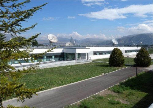
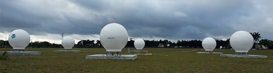
[Photo: Galileo’s Ground Mission Segment in the Fucino Control Centre in Italy oversees Galileo navigation services and satellite payload operations. Photo: Telespazio.]
The announcement points out that Galileo is currently in its initial services phase, wherein its signals are available for use in combination with other GNSS and do not provide a complete solution in and of themselves. This status is expressly designed to allow for “the detection of technical issues before the system becomes fully operational,” according to the GSA.
Indeed, experiments undertaken with Galileo-capable smartphones found that these devices excluded Galileo participation in their position solution. This is likely true of commercial receivers as well, which employ sophisticated signal checks as well as following system notice advisories, which have been issued in this case.
“For each constellation, there is a defined maximum age of ephemeris that is considered valid,” explained Sandy Kennedy, vice president, innovation at NovAtel. “Once an ephemeris is too old, our receiver will deem it invalid. Measurements made to satellites without a valid ephemeris are not allowed to contribute to the PVT solution. We noticed the missing Galileo ephemeris within 3 hours of the broadcast stopping. It wasn’t the NAGU that alerted us to the problem.”
The company posted a bulletin to its website on Friday afternoon, July 12, stating: “During this time [without ephemeris], NovAtel receivers will continue to track Galileo signals, but without a valid ephemeris, the signals are not included in the position solution. . . . Once the Galileo service returns to normal and transmits ephemeris information, NovAtel receivers will revert to normal operation.”
The experiments mentioned above were conducted by the Navigation Signal Analysis and Simulation (NavSAS) Group at Fondazione LINKS (formerly the Istituto Superiore Mario Boella) and the Politecnico di Torino. In their account they state that, using a software receiver that tracked the Galileo signals in space (SISs), “the position solution computed using both the GPS and Galileo constellation is affected by errors on the order of 500 meters or even more.”
In a detailed technical analysis, the NavSAS Group found three other curious and unexpected aspects of the situation, all explored and illustrated at the Group’s posting.
The entire Galileo system suffered an unexpected and hitherto unexplained signal outage, beginning on Thursday, July 11, at 1 p.m. Central European Time. At about that time, users noticed that all ephemeris stopped broadcasting, and then a Notice Advice to Galileo Users (NAGU) appeared:
NAGU Subject: Service Degradation
Satellite Affected: ALL
Event Description: Until further notices, users may experience service degradation on all Galileo satellites.s this means that the signals may not be available nor meet the minimum performance levels defined in the service definition documents and should be employed at users’ own risk. The nominal service will be resumed as soon as possible.”
The signal outage has persisted for more than two days (as of Saturday) and as yet no word has emerged as to the cause or duration of the signal outage.
On the evening of July 13, a second NAGU appeared, saying simply that “Until further notice, users experience a service outage. the signals are not to be used.”
On the European GNSS Service Centre’s constellation status page, 22 Galileo satellites are listed as “Not Usable” with cause being “Service Outage.”
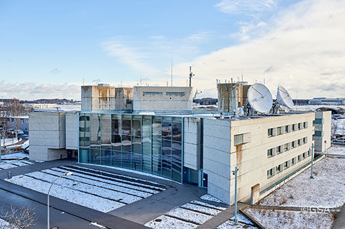
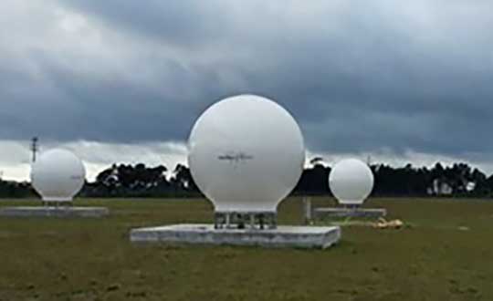
[Photo: Galileo Control Center, Oberpfaffenhofen. Photo: GSA]
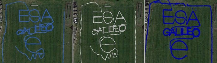
To test the accuracy of the competing satnav smartphone apps, the words ESA and Galileo were traced along ESTEC’s football field. The left side uses single-frequency GPS and Galileo signals, the center uses dual-frequency signals from the two constellations while the right is with precise corrections. The word “ESA” is 15 meters high, while “Galileo” is 7 meters high. (Photos: ESA)
News from the European Space Agency
Europe’s students and young researchers were challenged to design a smartphone app to take advantage of Galileo’s dual-frequency signals. The winning entries should soon be available to the public.
Run by ESA in collaboration with the European Global Navigation Satellite Systems Agency — GSA — plus the European Commission with the support of Google, a total of five teams made it to the final, which took place at ESA’s ESTEC technical heart in the Netherlands.
Following on from last year’s inaugural competition — which has already resulted in the winning app becoming publicly available — this year’s event challenged teams to make use of the dual-frequency capability of the latest smartphones running Android 8.0, including and computing dual-frequency positioning solutions from satnav signals to compare them with their single frequency equivalents. The competition slogan was “Galileo give mE5,” referring to Galileo’s dual E1 and E5 frequencies.
“Galileo give mE5”
The objective of the competition was to reach meter accuracy or less worldwide in unobscured sky, while allowing the user to select Galileo-only positioning, GPS-only positioning and the combination of both on a simultaneous basis, with the potential to include other satnav constellations in turn.
The winner was selected based on technical checks and a jury’s vote. Separate awards were also given to the most innovative app and the winner of a public vote.
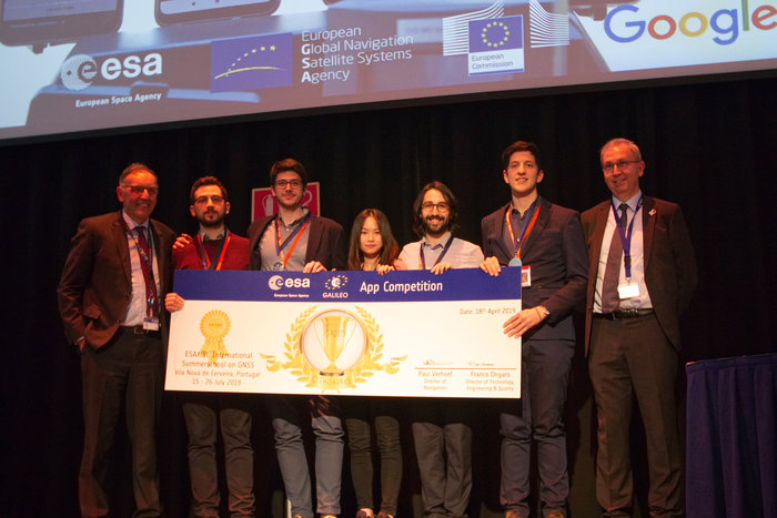
The multinational O ThiSaVRoS team — named after the Greek word for treasure — developed the “GNSS Android-based Dual Frequency Iono-estimating Precise Point Positioning” or GADIP3 app.
The multinational ‘O ThiSaVRoS’ team – named after the Greek word for treasure – developed the ‘GNSS Android-based Dual Frequency Iono-estimating Precise Point Positioning’ or GADIP 3 app, winning the ESA-EC-GSA Galileo smartphone app competition 2019. (Photo: ESA)
Winners
The app allows users to perform reliable positioning fixes in real time — selecting which constellations to employ and a choice of single or dual frequency signals — while advanced users can modify the way the positioning is performed, and log all available data for follow-up analysis.
“Our mission goal is to provide precise positioning to everyone,” explained team coordinator Lotfi Massarweh. The O ThiSaVRoS team performed analysis on more than 120 hours of data from stationary, pedestrian and mobile testing to come up with a pre-processing approach involving rejection of signals from low elevation and under a specific signal-to-noise ratio.
The five-person team hail from China, Greece, Italy and Spain, studying at Portugal’s Instituto Superior Técnico Lisboa, Delft University of Technology in the Netherlands, Germany’s Leibniz Universität Hannover and the Universities of Bath and Nottingham in the UK. They worked remotely to develop and test the app over the previous six months.
NavGate allows geo-tagging in augmented reality
The NavGate smartphone app allows the sharing of geo-tags in augmented reality via the phone’s camera, as well as on maps. (Image: ESA)
As their app’s name suggests, O ThiSaVRoS hope to achieve precise point positioning in future, made possible by dual-frequency signal availability, to come close to single-metre-scale precision.
Second place went to the ESTEC-based Team GNSS Tonic’s NavGate app — aimed at bringing people together socially to interesting locations. Users can tag sites of interest to be seen by other people, with the resulting geotags viewable for others either on a map or else directly in augmented reality through their phone’s camera. NavGate could potentially be used for everything from sharing dining recommendations to fishing spots, or meeting up with people during an evening out.
The third prize to the Step with GNSS app by the Romania-based Space Walkers Team, designed to gather data on the paths of users walking outdoors. This game based app is backed up by a server application collecting data from the app users and analysing GNSS performance worldwide or regionally.
Single versus dual frequency
The winner of both the public vote and the most innovative app award went to Universitat Autònoma de Barcelona’s Inari Team and their Inari app.
Inari allows users to select various positioning modes or customise their own, selecting which algorithms and which corrections should be employed as well as specifying constellations and signal frequency. The app can also highlight jamming or spoofing that might be influencing the positioning accuracy.
ESA’s technical evaluation team performed tests of the competing apps in the days running up to the final, including tracing out ESA GALILEO as accurately as possible across the establishment’s football field.
The speaker of the jury, Frank van Diggelen from Google, congratulated the teams on their efforts. “Dual frequency on smartphones is a quite new development, and you really are pioneers in this. The manufacturers are still trying to get things right, and you’re helping them do that bit better. Doing anything for the first time is hard but it’s good to be first, so congratulations for that,” he said.
Galileo smartphone app competition final
The receiver chipsets inside smartphones routinely make use of Galileo in combination with several other satnav constellations — the U.S. GPS, Russian Glonass and Chinese BeiDou. These chipsets function in ‘black box’ style, making the resulting positioning fixes accessible to users, but without giving any option to the user to select which constellation to employ — or information on Galileo’s particular contribution to the phone’s overall positioning performance.
However, in newer Android smartphones it has become possible to access the raw signal measurements used to compute position, opening the door to the development of applications where the user can indeed select which constellations to employ.
The very latest models also allow the use of dual satnav frequencies, giving a major boost to positioning precision. The higher chip rate of the additional frequency allows the chipset to compensate for signal propagation errors from the signals’ journey through the ionosphere — the electrically active outer layer of atmosphere — and reduces false ‘multipath’ detections caused by signals reflecting off buildings.
OK, perhaps the headline is a tad misleading. But in addition to its natural preoccupation with Galileo, the European Space Agency (ESA) has begun thinking and talking about PNT as a service and user needs. In 2018, the European Commission issued a memo saying that GNSS alone was not sufficient for many critical and fail-safe operations.
ESA is now seriously considering how Galileo and other systems can provide users the PNT services and resilience they need, regardless of whether the signals come from space.
They have also issued a permanent Request for Proposals in this area. From their website:
The goal is to maintain and improve the capability and competitiveness of the industry of the participating States in the global market for Satellite Navigation, and more broadly PNT technologies and services. In this context, the wider ambition towards the overall PNT sector is justified by the necessity to facilitate cross-fertilisation between space-based and terrestrial positioning technologies.
This programmatic action will ensure the readiness of the industry to effectively respond to emerging market opportunities by focusing its activities on products ready for the commercial or institutional market.
The development of ad hoc technologies and product development activities along the whole Satellite Navigation value chain and more broadly PNT products can be proposed by industry to develop products aligned with their plans for future exploitation.
Activities therefore shall have been identified by industry as having clear potential for being applied in the area of PNT. The activities may address completely new products of a disruptive nature, may be an upgrading or improvement of an existing product or may address a continuation of an activity funded in another framework within another European institutional programme, a national programme or an industrial/academic research programme. The activities shall aim at resulting in a product ready for commercial exploitation.
Implemented through a continuous open call capable of stimulating unsolicited proposals, the eligibility of which will be indicated by the relevant participating State (i.e. support letter). The pre-commercial nature of this programme element will call for a co-funding approach to be envisaged.
Proposals must be from companies in the EU states of AT, CA, CH, CZ, DK, ES, FR, FI, UK, IT, IE, NO, NL, PL, PT, RO, SE and DE.
In February I had the privilege of addressing the European Space Agency’s (ESA’s) Navigation Days conference in the Netherlands. An internal ESA event, Navigation Days gathers engineering staff from centers in several countries to discuss the present and future of their endeavors.
Since most of the audience had been “bathing” in Galileo, EGNOS and the evolution of both systems for many years, the Director of Navigation and the Galileo Project Manager thought it would be interesting for all to have an “outsider” perspective and opinions on Galileo and the European GNSS position in the world.
Though my half-hour talk ranged freely, and perhaps somewhat wildly, across many sectors and subjects, it had two main foci: the fundamental differences between Galileo and the three other GNSS, and the future portended by those differences. A future column here will address the latter, that is, the future. At present, the present distinctions.
To me, they distill down to three elements: active stimulus of market development, well-funded research into new applications, and — actually the foundation stone of the afore two — democratically elected governments representing citizenry with altruistic values: a strong desire for the common good, thoughtful regulation, intertwined diversity and open borders.
In sum, Galileo’s strength is the strength of the European Union.
“Active stimulus of market development, well-funded research into new applications, and citizenry with altruistic values.”
For example, the Horizon 2020 framework program offers €80 billion to support and foster research from 2014–2020. Three E-GNSS calls in H2020 have a total budget of €100.9 million and they synergize with topics on societal challenges. To my knowledge, the U.S. has nothing like this in terms of downstream R&D programs; it is left to the marketplace to initiate and sustain such efforts.This corresponds to the respective economic systems of the two political entities. West of the Atlantic has historically taken a laissez-faire attitude towards applications, development and societal challenges: let the marketplace act.
The other two GNSS powers, Russia and China, as authoritarian regimes, may build viable GNSS and mandate their use, but the synergy between government and users is lacking. This missing link could prove an economic as well as technical weakness in the future. In some respects, it already has.
Particularly in transportation, freight and liability-critical applications, where the European GNSS have devoted extensive forethought to both user and societal needs (read “the environment”), we may see a distinctly different and more progressive future unfolding in Western Europe, led by Galileo.
On the other hand, in the realm of pure consumer devices, the market may be a stronger driver, and U.S. products and services with a GPS bent may remain dominant.
The Public Regulated Service (PRS) for defense, security, emergencies and critical infrastructure, is the hidden strength of Galileo.
I’ve run out of space here for non-scientific speculations, but will expand them in a future column or online.
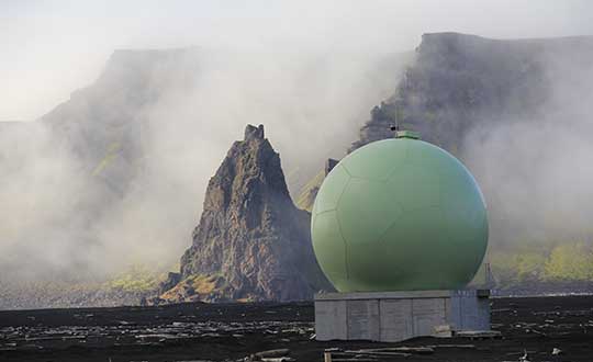
Protective radome housing for the Galileo ground station on desolate Jan Mayen Island in the Norwegian Arctic. The site is housing a Galileo Sensor Station plus satellite link to pass data back to the Galileo ground system. (Photo: ESA/Fermin Alvarez Lopez)
CGI has signed an agreement with Thales Alenia Space France to enhance and maintain security software for the Galileo satellite navigation system.
Valued at approximately 14 million euros, the contract will last until the end of 2020. CGI experts are working on this strategic project from Rotterdam and Toulouse.
CGI will improve the functionality, robustness and reliability of Galileo’s ground infrastructure, as well as enhance and maintain software for its Public Regulated Service Key Management Facility (PKMF).
The Public Regulated Service (PRS) is one of the key features that distinguishes Galileo from other satellite navigation systems. It ensures that only government-authorized entities have access to Galileo’s secure PRS signal that meets strict security standards in areas such as defense, law enforcement and customs.
“We look forward to working with CGI to ensure the highest level of security for Galileo, along with an efficient, high performance infrastructure,” said Guillermo Salgado, Galileo ground mission and EGNOS programs director, Thales Alenia Space France. “CGI’s significant space and security experience, combined with its local presence and global resources, gives us access to the experts we need to launch and operate one of the world’s most advanced satellite navigation systems.”
“CGI has strong legacy in space, and we continue to support space clients across the globe, actively managing their business and national interests while positioning CGI as a trusted space leader,” said Dirk de Groot, who leads CGI’s business unit in the Netherlands.
CGI has more than 40 years of experience in the space domain and delivers complex, mission-critical space software systems across Europe, Asia and North America, supporting programs from satellite navigation, communications and operations, to space-enabled applications.
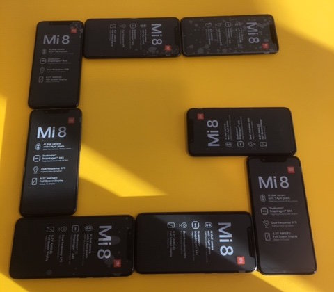
Xiaomi Mi 8 dual-frequency smartphones procured for teams participating in ESA’s second Galileo App Competition, taking place at ESTEC in the Netherlands on April 18. (Photo: ESA)
The final presentations of ESA’s second Galileo smartphone app competition will take place April 18. The public is invited to watch the awards ceremony via livestream.
The competition’s goal is to develop an app capable of performing fixes using raw Galileo satnav measurements. Members of the public can also vote for their favorite app.
Five teams are competing this year. The competition is run by the European Space Agency (ESA)
in collaboration with the European Global Navigation Satellite Systems Agency (GSA) plus the European Commission with the support of Google. It was open to all students from European universities and trainees in posts at European research and development organisations.
Orolia has successfully installed the first operational Cospas-Sarsat second-generation technology on search-and-rescue ground stations for the National Oceanographic and Atmospheric Administration (NOAA) in Florida and Hawaii.
The ground stations have been upgraded with second-generation beacon (SGB) signal-processing capabilities to more accurately and quickly locate the source of distress signals.
The NOAA Florida and Hawaii ground stations are the only operationally ready Medium Earth Orbit Search and Rescue (MEOSAR) ground stations in the world to receive the SGB signal specification capability.
The Cospas-Sarsat global search-and-rescue system developed specifications for the second-generation 406-MHz search-and-rescue beacon, which uses a modern, spread-spectrum signal to achieve more accurate and robust performance.
“The work performed by Orolia was exceptional, as the process of upgrading an operational system to a higher set of requirements, years after its initial design, involves minimizing downtime while validating the new requirements and revalidating the previous requirements,” said Mickey Fitzmaurice, NOAA SARSAT Systems Engineer. “The successful result makes it obvious that the engineering and operations team at Orolia put a great deal of time and effort into planning the upgrade, as the execution was seamless.”
“This series of world firsts demonstrates Orolia’s broad technical leadership in the global search and rescue ecosystem,” said Orolia Director of SARSAT Operations, Steve Ludwig. “We continually innovate to enhance the usefulness of these technologies, from generating encrypted beacon alert signals to including alert authentication through the use of Galileo Return Link Service.”
Cospas-Sarsat ground stations are called Local User Terminals (LUTs). These satellite receiving units are the ground stations that receive emergency beacon distress alerts. (Photo: NOAA)
Check out some GPS developments that have recently taken place around the world. (Click to enlarge; Map: iStock.com/nadla)
1. When horses answer the call
Taking a ride in a horse-drawn carriage delights many visitors to historic Charleston, South Carolina. Until now, city crews cleaning up the presents horses leave behind have relied on flag indicators left by carriage operators. Now the city is testing a new method. Carriage operators will send the exact location to equine sanitation crews using small GPS-enabled devices. When a horse or mule takes an on-street nature break, the guide presses a button, and the equine sanitation crew is notified of exactly where to go. When the cleanup is complete, the notification is deleted.
2. Detecting rain over the ocean
Despite a wide variety of monitored geophysical parameters, GNSS signals reflected off the Earth’s surface (GNSS reflectometry) have never been used to obtain rain information. A new study presents evidence that data from the U.K.’s TechDemoSat-1 potentially enables the GNSS-R technique to detect precipitation over oceans at low winds. The study — by scientists at the GFZ German Research Center for Geosciences at Potsdam — could serve as a starting point for developing a new GNSS reflectometry application, which might also be implemented for low-cost GNSS remote-sensing missions.
Click to enlarge. (Photo: Chocolateam)
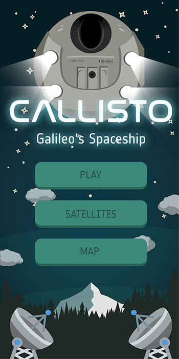
3. Gaming with Galileo
Gamers around the world can now play with the Galileo constellation. Callisto for Android uses Galileo signals in a virtual maze game based on walking through a real-world location. Looking down on Earth as if from a spaceship, players use a Google Map display to traverse an area filled with randomly generated obstacles and collectibles. The project began as an entry to European Space Agency’s Galileo App Competition 2017–2018 and was one of three apps that made it to the finals.
4. Guinness decision pending on world’s steepest street
Dunedin, New Zealand, claims to have the world’s steepest street (Baldwin), a title officially challenged in January by the town of Harlech, Wales, when residents walked up and down the narrow, winding Ffordd Pen Llech carrying a GNSS surveying receiver. A total of 14 data points were recorded on the 330-meter-long road, which had an altitude accuracy of ±5 centimeters. New Zealand surveyor Richard Hemi said the GNSS method used by the Welsh group might not be accurate. Best accuracy is to survey from the center of the road — easy on Baldwin St. but much more difficult on a winding lane. The survey was sent to Guinness World Records, which will issue a decision this spring.
Following a waiver by the U.S. Federal Communications Commission (FCC) of its rules in November 2018, in which it allowed devices in the United States to access signals transmitted by the Galileo Global Navigation System, leading U.S. manufacturers are preparing to roll-out Galileo on U.S. territory.
At a meeting on Nov. 15 last year, the US FCC granted in part a request from the European Commission for a waiver of the FCC rules so that devices in the United States may access specific signals transmitted by Galileo.
This decision means that consumers and industry in the U.S. are now able to access certain satellite signals from the Galileo system, which can be used in combination with the U.S. Global Positioning System (GPS). The improved availability, reliability, and resiliency offered by incorporating Galileo capability into devices is something that U.S. chip manufacturers are eager to pass on to their customers.
“This is an important market development opportunity for manufacturers in the U.S. The FCC ruling means that industry can now benefit from the use of Galileo signals. The added accuracy and robustness offered by multi-constellation and multi-frequency capability will be a key differentiator on the market,” said Carlo des Dorides, Executive Director of the European GNSS Agency (GSA).
“We are glad to see FCC supporting Broadcom’s dual frequency GNSS vision, for which the GPS and Galileo combination is key,” said Vijay Nagarajan, VP Marketing Wireless Connectivity and Communication Division at Broadcom. “We enabled the world’s first dual frequency GNSS phone in 2018 with the simple goal of providing accurate location to the consumer even amidst the skyscrapers in a busy downtown. We are certain that consumers will benefit from this FCC ruling that will further drive the adoption of dual frequency GNSS.”
“As a leader in developing cellular technology — today, as the world launches 5G and dating back to Qualcomm’s legacy in 4G, 3G and 2G — including work to incorporate robust navigation solutions for smartphones, Qualcomm Technologies integrated Galileo across its chipset portfolio because we understand the importance and benefits of accurate, reliable, and rapid position location for consumers,” said Dean Brenner, senior vice president of Spectrum Strategy and Tech Policy, Qualcomm Incorporated. “We’re excited about the FCC allowing access to Galileo signals in the U.S. for commercial Location Based Services because it is a big step forward in improving the user experience, particularly in dense urban environments.”
Activating Galileo in the U.S.
Both Broadcom and Qualcomm Technologies, Inc. already have dual-frequency solutions that support Galileo E1/E5a signals: the world’s first dual frequency GNSS smartphone, the Xiaomi Mi-8, was fitted with a Broadcom BCM47755 chip and, in December, Qualcomm Technologies launched the newest generation in its 8 Mobile Platform Series, the dual-frequency Qualcomm Snapdragon 855 Mobile Platform.
“Approximately 100 smartphone models are already fitted with chipsets from these two manufacturers. Following the FCC ruling, we are expecting to see a significant increase in Galileo users coming from the U.S.,” said Justyna Redelkiewicz Musial, in charge of LBS and IoT market development at the GSA.
Better positioning and navigation
The FCC ruling permits access to two Galileo signals — the E1 signal that is transmitted in the 1559-1591 MHz portion of the 1559-1610 MHz Radio-navigation-Satellite Service (RNSS) frequency band and the E5 signal that is transmitted in the 1164-1219 MHz portion of the 1164-1215 MHz and 1215-1240 MHz RNSS bands.
Access to multi-constellation and multi-frequency capability means that users in the U.S. will be able to benefit from a better positioning and navigation experience particularly in urban environments where the unique shape of the E5/L5 signal makes it easier to distinguish real signals from the ones reflected by buildings, reducing the multipath effect. The simultaneous use of E5/L5 frequencies also mitigates other sources of error, such as ionospheric distortions, and makes the signal more robust against interference and jamming.
Responsibility for in-depth troubleshooting and problem resolution of the GSC Ground Infrastructure has been transferred from a European GNSS Agency (GSA)-held European GNSS Service Centre (GSC) infrastructure contract to Spaceopal and its core team member DLR GfR, responsible in the Galileo Service Operator (GSOp) industrial organization also for L2/L3 maintenance activity. This contract extends for 10 years.
The transfer occurred after Spaceopal successfully passed the Maintenance Handover Review (MHOR) for the Level 2 and 3 Maintenance of the GSC in Torrejón de Ardoz, outside Madrid, Spain.
“Taking over this responsibility will allow us to react much quicker to anomalies in a more flexible way, directly improving operations and the service that the European GNSS Agency (GSA) provides to the Galileo end users,” said Christian Hessmann, Engineering Manager at Spaceopal.
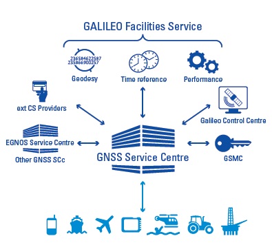
The GSC services can be accessed by Galileo users via the GSC web portal.
Spaceopal is a joint venture between DLR Gesellschaft für Raumfahrtanwendungen (GfR) mbH, a full subsidiary of the German Aerospace Center (Deutsches Zentrum für Luft- und Raumfahrt; DLR), and the Italian firm Telespazio S.p.A. Both parties contribute their respective Galileo Control Centers in Oberpfaffenhofen and Fucino.
Since July 2017, Spaceopal GmbH has operated the Galileo satellite fleet under the GSOp contract and will thus ensure the provision of the Galileo services to the worldwide community.
The GSC provides the single interface between the Galileo system and the users of the Galileo Open Service (OS), and the Galileo Commercial Service (CS) for the provision of specific services beyond the Galileo Signal-In-Space (SIS) transmitted by the operational satellites. The GSC acts as an active means to engage in “in”- and “out” bound activities and is conceived as a centre of expertise, knowledge sharing, custom performance assessment, information dissemination and support to the provision of value-added services enabled by the Galileo OS and CS core services.
The GSC is located in a fully secured environment in Madrid, Spain, within the National Institute of Aerospace Technologies (INTA) facilities at Torrejón de Ardoz, overseen by the Spanish Ministry of Defence.
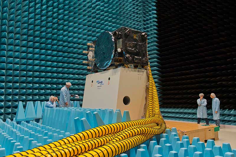
Inside the ESTEC Test Center, Galileo’s First Operational Capability first flight model, FM1, prepares for passive intermodulation testing in the Maxwell electromagnetic facility. (Photo: ESA-Anneke Le Floc’h)
Gazing through soaring plexiglass walls at the space simulation room of the European Space Agency’s Test Center in the Netherlands affords a glimpse into scientific history.
I felt a frisson, a highly regimented frisson if you will, of vicarious thrill for the rigors, rhythms and methods of research and testing as I toured the center after giving a keynote at the agency’s Navigation Days. Here, the final birthing touches were administered to transmitters beaming forth the Second Golden Age of satellite-based navigation.
One can debate which constellation combination will prove most fruitful to users: GPS plus GLONASS, GPS plus BeiDou, GPS plus Galileo (note the common term). I believe it will be the last, because of the close synergy and symbiosis of the two commercial arenas, North America and Europe.
All Galileo Full Operational Capability (FOC) satellites had their mettle and metals probed, radiated, bombarded, shaken and shocked here before they journeyed to space. The test center’s role is to verify, intensively and for months per satellite, that it can perform well for the whole of its planned lifetime.
A mass property test checks that the center of gravity and mass are aligned within design specifications, so that the satellite’s orientation can be accurately and economically controlled with thruster firings in orbit, prolonging work life by conserving propellant.
A five-week thermal-vacuum test runs inside a 4.5-meter diameter stainless steel vacuum chamber, the Phenix. An inner thermal tent heats to simulate solar radiation and cools with liquid nitrogen to create the chill of sunless space.
In the Maxwell test chamber, spiky radio-absorbent anechoic walls test electromagnetic compatibility to ensure that all systems operate together without interference. Noise horns generate more than 140 decibels to simulate a violent launch. A quad shaker table vibrates the satellite up, sideways and down, as accelerometers search for hazardous internal vibration, gathering data across hundreds of channels.
Altogether a severe trial, a crucible from which the FOC satellites emerge certified and ready for space.
Oh, that we humans were similarly tested before placement in positions of power.