Category: Galileo

  • Directions 2020: Galileo Moves Ahead

    Directions 2020: Galileo Moves Ahead

    By Javier Benedicto
    Head, Galileo Programme department,
    European Space Agency

    Javier Benedicto, left, accept the Satellites Leadership Award on behalf of Giuliano Gatti of the European Space Agency, from Phil Froom of Rockwell Collins. (Photo: Melanie Beus)
    Javier Benedicto, left, accept the 2018 GPS World Satellites Leadership Award on behalf of Giuliano Gatti of the European Space Agency, from Phil Froom of Rockwell Collins. (Photo: Melanie Beus)

    Since the Galileo initial services declaration in December 2016, the Galileo Program has been providing global PNT and search-and-rescue services for users worldwide. The European GNSS Agency (GSA) just issued its GNSS 2019 Market Report in October, providing a complete overview of the current status and trends of the GNSS worldwide market with focus on European GNSS (Galileo and EGNOS) applications and services.

    In parallel with service provision, the Galileo Program is undertaking extensive infrastructure development and deployment activities to reach Full Operational Capability (FOC), incorporating new service capabilities, but above all aiming at increasing the robustness and resilience of the system infrastructure, operations and service provision.

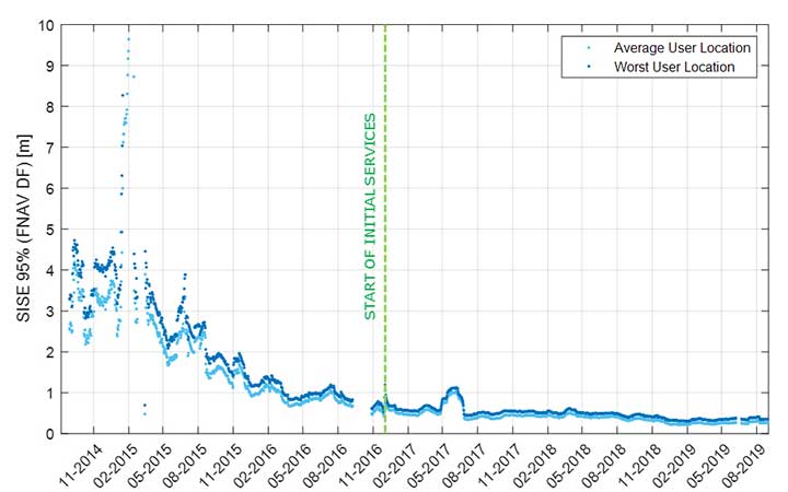
    Galileo’s signal-in-space quality has steadily improved over the past few years, reaching in 2019 a best signal-in-space error (SISE) of about 0.25 meters (95%, global average; Figure 1). This has been achieved through a combination of several factors, including the increased number of operational satellites, enhanced versions of the Ground Mission Segment, and higher uplink rate of the navigation message (lower age of data). This performance is well within Galileo’s initial service accuracy commitments, as defined in the public Open Service – Service Definition Document (OS SDD).

    Figure 1. Long-term historical SISE plot over a 30-day sliding window, constellation averaged. (Image: ESA)
    Figure 1. Long-term historical SISE plot over a 30-day sliding window, constellation averaged. (Image: ESA)

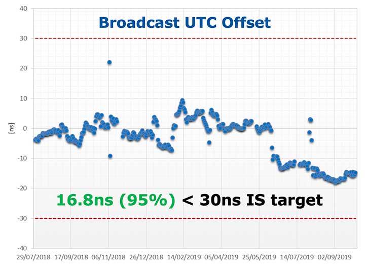
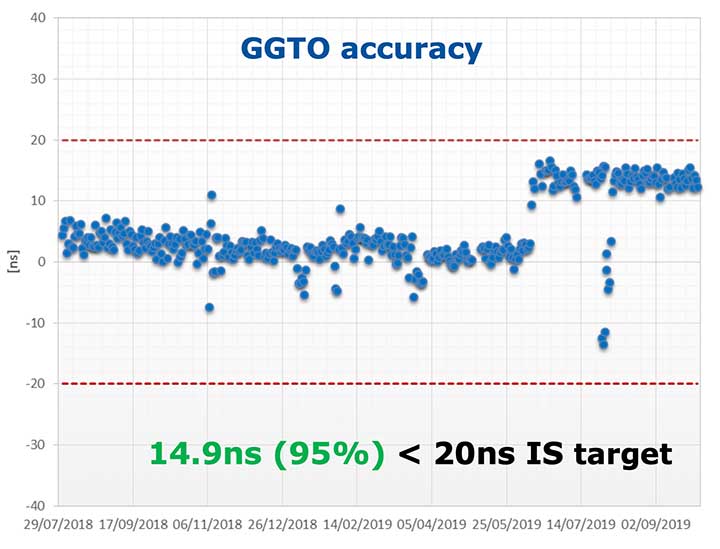
    Figures 2 and 3 (see page 40) show Galileo’s timing performance as broadcast UTC offset and GGTO accuracy. The evaluation was performed with calibrated GPS/Galileo timing receivers operated in UTC(k) laboratory (PTB, INRIM). Again, the initial timing service commitments have been fully met.

    Figure 2. Galileo Broadcast UTC offset accuracy performance. (Image: ESA)
    Figure 2. Galileo Broadcast UTC offset accuracy performance. (Image: ESA)
    Figure 3. Galileo GGTO offset accuracy performance. (Image: ESA)
    Figure 3. Galileo GGTO offset accuracy performance. (Image: ESA)

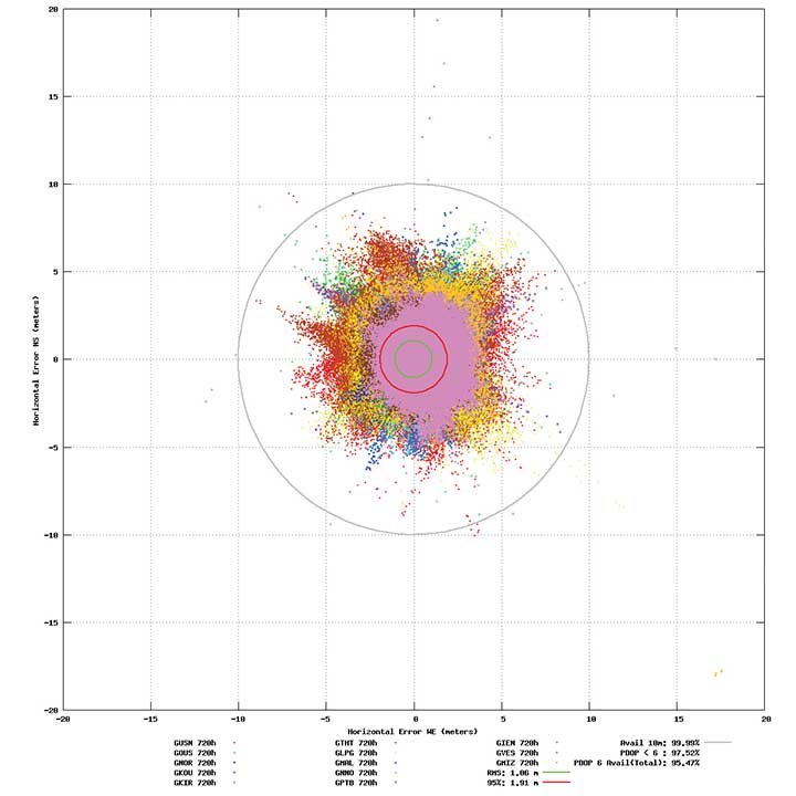
    Probably the most significant discriminator of Galileo compared to other GNSS is its capability to broadcast multi-frequency (E1, E6, E5) signal components on all operational satellites. The position performance of a dual-frequency user receiver on-ground is shown in Figure 4. This measurement from June 2019 demonstrates a Galileo position accuracy well below 2 m (95%).

    Figure 4. Galileo position accuracy performance, dual-frequency, June 2019. (Image: ESA)
    Figure 4. Galileo position accuracy performance, dual-frequency, June 2019. (Image: ESA)

    With the aim of further improving the Open Service (OS) performance, three newly introduced I/NAV message improvements on Galileo E1-B are under implementation, namely FEC2 Reed-Solomon Clock and Ephemeris (CED), Reduced CED, and Secondary Synchronization Pattern (SSP). Galileo Open Service (OS) users will benefit from improved robustness in terms of navigation data retrieval in challenging environments, in addition to facilitating a reduced time to first fix. Those I/NAV improvements on Galileo E1-B are backwards compatible with previously released OS SIS ICDs.

    In addition, Galileo infrastructure is currently being upgraded to provide means for OS authentication. The protocol proposed uses the E1B External Data Broadcast Service (EDBS) to provide authentication data to the user. The OS Navigation Message Authentication (NMA) is based on an adaptation of the Timed Efficient Stream Loss-tolerant Authentication (TESLA) protocol.

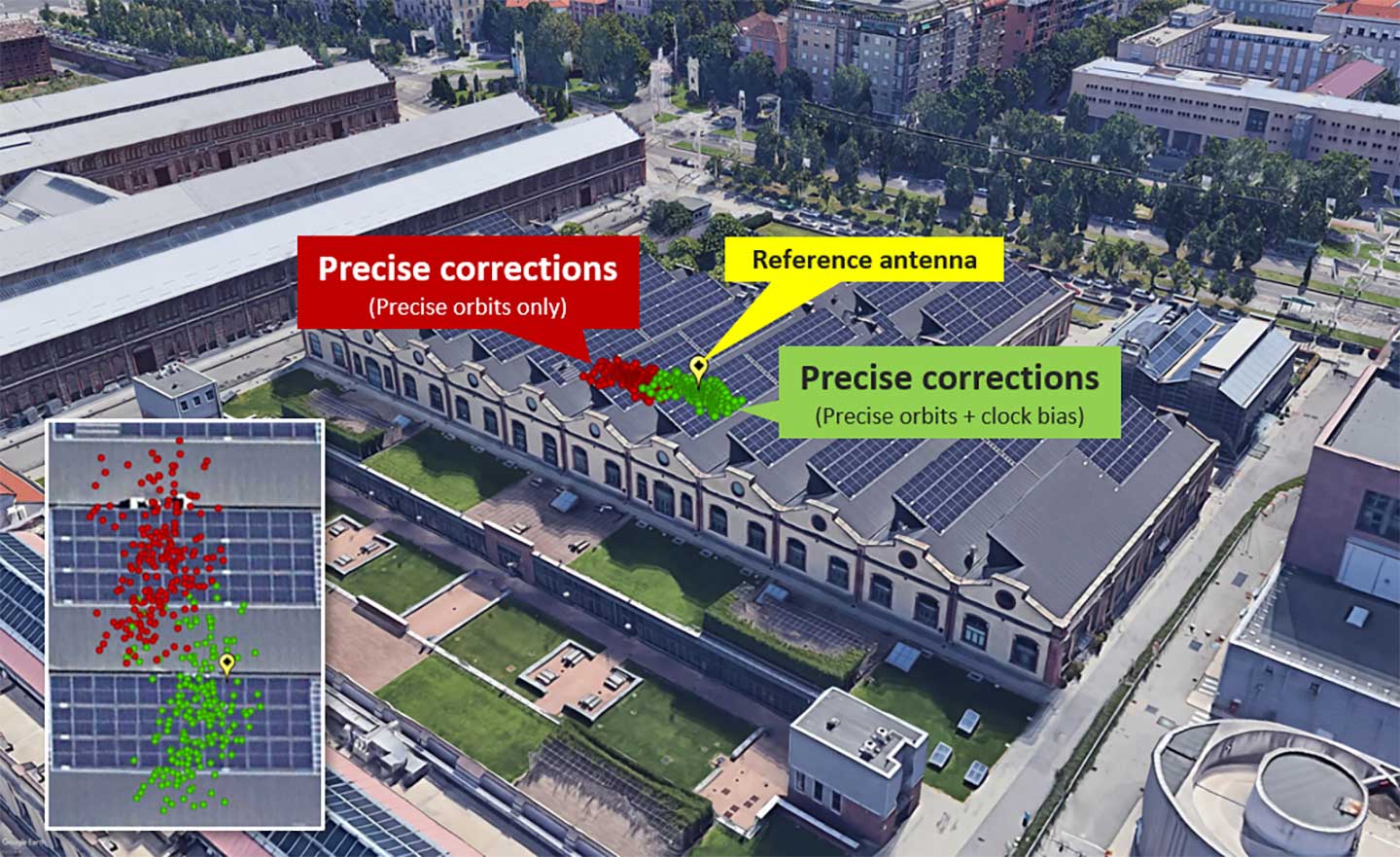
    Beyond the OS, the Galileo system has been designed to allow for the dissemination of value-added data, such as high accuracy and authentication, in the E6B signal component. The component has been designed to broadcast the Galileo High Accuracy Service based on the provision of accurate satellite data (clocks, orbits and biases) and atmospheric data (mainly ionospheric corrections) to enable multi-frequency multi-constellation PPP with correction data transmitted through an open format in the Galileo E6B signal.

    The introduction in early 2020 of the automatic acknowledgment of the SAR/Galileo Return Link Message (RLM) as part of the Cospas-Sarsat system will enable space assets to be used for search and rescue — persons in distress will get swift acknowledgement that their alert has been detected and located. The Return Link is the means to interact with a SAR beacon, improving the effectiveness of SAR operations. Extensive testing has demonstrated that the median latency for the reception of a return link message on the ground is 14.2 seconds, while 99% of messages are received within 57 seconds, after the request for the RLM transmission is delivered to Galileo (from Cospas-Sarsat to the RLSP). At the same time, the measured rate of reception was 100%, considering line-of-sight availability, thanks to the very robust Galileo navigation data link. This performance has been demonstrated to be uniform across the globe, as shown in Figure 5.

    Figure 5. Beacon activation map and RLM delivery latency through the Galileo system. (Image: ESA)
    Figure 5. Beacon activation map and RLM delivery latency through the Galileo system. (Image: ESA)

    Following the re-profiling of the Galileo Safety-of-Life (SoL) service, Galileo is meant to be exploited through dual-frequency multi-constellation (DFMC) SBAS and will support the provision of integrity through the concept of Horizontal Advanced Receiver Autonomous Integrity Monitoring (H-ARAIM). To allow the exploitation of Galileo for these SoL applications, a thorough analysis of the actual signal-in-space (SiS) performance and of potential feared events critical for SoL users is key. In this context, the Galileo Integrity Failure Mode and Effect Analysis (IFMEA) process is implemented through measurements and review of the system design, including feared-events characterization.

    Ground Segment Brings Robustness

    Galileo telemetry and telecommand ground station. (Photo: ESA)
    Galileo telemetry and telecommand ground station. (Photo: ESA)

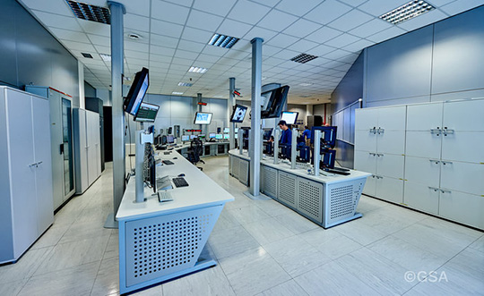
    Galileo’s Ground Segment is being upgraded to fully redundant control centers. These include processing and storage, monitoring and control facilities, and security monitoring centers. A worldwide network of Galileo Sensor Stations (GSS) allows monitoring and measuring of satellite signals; uplink stations allow dissemination of the navigation message to users through Galileo satellites; and telemetry, tracking and control (TTC) stations allow monitoring and control of the satellites.

    Ground segment upgrades under production by Thales Alenia Space France (in charge of the ground mission segment and security monitoring) and GMV Spain (in charge of the ground control segment) are addressing increased service robustness, through the introduction of a more flexible infrastructure with a significant technology refresh, improved security, service continuity, enhanced service performances, and enhanced operability features.

    One important objective of the ongoing upgrades is to implement a modern infrastructure, based on leading virtualization technologies. This modernized infrastructure will make it possible to easily accommodate hardware and software changes without requiring significant redesign or requalification, and will minimize the impact to Galileo service operations — under responsibility of Spaceopal GmbH — during future deployment activities.

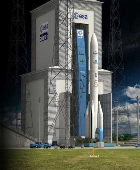
    Batch 3, Ariane 6 Under Production

    Ariane 6 on the launchpad. (Artist's concept: ESA)
    Ariane 6 on the launchpad. (Artist’s concept: ESA)

    The production of Batch 3 of 12 additional Galileo FOC satellites is proceeding, aiming at readiness for launch by the end of 2020 onward. The satellite design includes a selected number of improvements compared to the 22 FOC satellites launched previously and built by the same satellite manufacturer OHB Systems.

    The different stages of assembly, integration and initial test phase in the OHB production plant in Bremen have already started, before shipment to ESA-ESTEC in the Netherlands for the environmental test campaign consisting of thermal vacuum, mechanical tests, interface verification with the launcher and system end-to-end performance tests with the elements of the Galileo ground segment.

    Following the phasing out of the Ariane 5 SE launcher, the third batch of Galileo satellites will be progressively launched with the new Ariane 62 launcher vehicle, the two solid-booster variant of Ariane 6 now in the final stages of development.

    Evolution to Meet User Needs

    The Galileo Second Generation roadmap has achieved maturity in 2019 and is now entering the preliminary design and implementation phase. Based on the EU’s H2020 Galileo Second Generation activities managed by ESA, and the GSA prospective market analysis, the European Commission, in close consultation with EU member states, has agreed on an ambitious set of long-term PNT goals for the future European GNSS infrastructures.

    Technology pre-developments, critical engineering activities and synergic design activities between space and ground infrastructure are being conducted. This will translate into the progressive deployment of a complete set of space/ground infrastructure that is tailored to satisfy the diversified user needs in four main dimensions:

    • Satellite and ground segment infrastructure with capabilities that can dynamically adapt to current and future user needs. Key drivers are flexibility and robustness, ensuring fast time to market to meet user needs.
    • Full synergy between GNSS and SBAS systems infrastructure, to complement and enhance the service portfolio. This will allow segmentation and complementarity of safety-critical services and extension to all new PNT services available today, including high-accuracy positioning integrity.
    • Enhanced integration with terrestrial systems — 5G/6G, signals of opportunity (SOOP), terrestrial beacon systems (TBS). ESA and GSA have been actively leading the 5G positioning standardization worldwide in collaboration with public and private institutions inside 3GPP and will soon move toward the start of standardization of 6G terrestrial positioning and GNSS interconnection technologies.
    • Full complementarity with external sensors (such as INS, barometer and lidar) and application environments (low-power devices and internet of things) so that the Galileo Second Generation Infrastructure enhances and complements the capabilities provided by these external means.

    A key pillar for this long-term strategy is the Galileo transition satellites. The competitive procurement procedure for the first batch of transition satellites is coming in 2020. The flexibility and robustness of these satellites will allow the European PNT infrastructure to satisfy all the different user needs in the next decade. This procurement — together with others at system, ground segment and technology level — will enable the start of the in-orbit validation of second-generation capabilities from 2025 onward.

    Additional ground and test infrastructure are in early engineering analysis, design and technology development, in order to proceed with additional procurements for experimental and operational usage, starting early in the 2020s.

  • GSA announces 2019 winners of MyGalileoApp competition

    GSA announces 2019 winners of MyGalileoApp competition

    First place winners ARGEO accept their prize. (Photo: GSA)
    First place winners ARGEO accept their prize. (Photo: GSA)

    News from the European GNSS Agency

    The winners of this year’s MyGalileoApp competition were announced at a ceremony held at the European GNSS Agency (GSA) headquarters in Prague on Nov. 7.

    First prize of EUR 100,000 went to ARGEO, a mobile app based on geolocation, augmented reality and blockchain that allows users to discover content such as prizes, coupons and shopping cards geo-located around the streets of a city.

    Second prize, worth EUR 50,000, went to the Tractor Navigator app, which provides guidance for farmers driving tractors, enabling them to visualise their position and trajectory in an open field. Finally, the EUR 30,000 third prize went to Ready Park, an app that makes parking easier by pairing drivers leaving a spot with users looking for one.

    The 10 finalists from eight countries made their pitches to a panel of jurors throughout the afternoon of Nov. 7, after which the jury reached its decision on the winning apps.

    Welcoming the competitors to the finals, GSA Executive Director Carlo des Dorides noted that the 10 finalists had been selected from a total of 150 competing teams, representing more than 35 nationalities.

    “The MyGalileoApp competition is the largest app development competition ever organised within the Galileo programme. After reaching 1 billion smartphones equipped with Galileo earlier this year, the next big challenge is to develop applications that will make best use of the Galileo differentiators,” des Dorides said.

    Following the pitches was an investors’ panel, with presentations by experts from various institutions, including venture capital firms and accelerators, providing information on how apps can bridge the gap between great ideas and viable business opportunities.

    “Private and public investors will have an opportunity today to expand their investment portfolio with the Galileo apps generated by the competition, helping to transform the apps into commercial successes,” des Dorides said, adding that the goal of the MyGalileoApp competition was not just to make beautiful apps, but to create jobs and generate economic growth. For a full agenda of the day’s events, click here.

  • GSA stresses key role of GNSS at Intergeo workshop

    GSA stresses key role of GNSS at Intergeo workshop

    GSA Market Development Innovation Officer Eduard Escalona speaks at the Intergeo Galileo workshop. (Photo: GSA)
    GSA Market Development Innovation Officer Eduard Escalona speaks at the Intergeo Galileo workshop. (Photo: GSA)

    News from the European GNSS Agency (GSA)

    Galileo and EGNOS were the focus of attention at a special workshop at this year’s Intergeo in Stuttgart, which took place in September. Intergeo is the world’s leading conference and trade fair for geodesy, geo-information and land management.

    Intergeo provided an opportunity to give an update on the status of the Galileo and EGNOS programs and to present user case studies at a special workshop focusing on the geomatics market.

    In his presentation at the conference, Eduard Escalona, Market Development Innovation Officer at the European GNSS Agency (GSA), stressed the key role of GNSS.

    “GNSS is a cornerstone in many areas: It is a fundamental element for cadastral surveying, in the construction sector, in mining, land surveying and mapping activities, for all geographic information systems (GIS), for infrastructure monitoring and for marine surveying. For all of you who are working in these and many other areas, Galileo is now helping to provide the GNSS services you need,” he said.

    Dual-frequency boosts market

    The European GNSS programs, Galileo and EGNOS, continue to move forward in terms of adoption by the professional market and among general users, thanks in no small part to the development of dual-frequency capability.

    Traditionally, mobile, location-based applications have been powered by single-frequency GNSS receivers operating under stringent battery-power and footprint constraints. With a dual-frequency chipset, these devices now benefit from better accuracy, ionosphere error cancellation, improved tracking and better multipath resistance.

    Galileo is leading the way in the area of dual-frequency signal delivery, now with more dual-frequency operational satellites in orbit than any other GNSS system. Market uptake of Galileo receivers has been impressive; in addition to the geomatics-related areas of particular interest to the Intergeo public, dual-frequency GNSS chipsets are also appearing in the automotive sector, where connected cars and autonomous vehicles present a clear and pressing need for accurate and reliable positioning information.

    New services to come

    “To date, more than one billion Galileo-enabled devices have been sold,” said Escalona, “but Galileo isn’t standing still, waiting. We are proposing new services to appear in the coming years.”

    These include the much-anticipated High-Accuracy Service (HAS) and a new Authentication Service. “The HAS will be a free, globally available service providing an accuracy of 20 cm, with PPP [Precise Point Positioning] corrections,” Escalona said.

    Meanwhile, the Authentication Service (OS-NMA) will provide protection against jamming, spoofing and meaconing on the E1B signal and a separate Signal Authentication Service (SAS) will provide an even higher level of protection on the E6 signal.

    “EGNOS is currently working with GPS, but of course we are looking forward to augmenting Galileo in the near future,” said Sergio Cabrera Bona, EGNOS Service Adoption Tools Engineer at the European Satellite Services Provider, whose core activities comprise EGNOS operations and service provision.

    “GNSS is critical in all of these fields, whether it is mapping and GIS, farming, forestry, thermal pictures, management of natural terrains,” Cabrera said. He listed other areas, including management and inspection of utilities, power networks, water supply, telecoms, drones, inventory, surveying, field campaigns and determination of perimeters in agriculture as areas where GNSS plays a key role.

    “It is not possible to mention all of the activities where you need reliable positioning. What you have to know is that with EGNOS augmentations you already have a horizontal accuracy below one metre and a vertical accuracy below two metres, so this is a very good accuracy,” he said.

    There is much more that could potentially be done right now, Cabrera explained. “Most of the professional equipment is already EGNOS-enabled, but in practice users do not always configure their equipment correctly to exploit this capability. EGNOS adoption and support is going ahead full speed, but in the GNSS device market, many users still do not know they can use EGNOS. So the education process remains an ongoing effort,” he said.

    Cabrera explained that the EGNOS user support website can be an important part of this educational drive on the top of the help desk. “We have very interesting tools and resources available online. For example, we will have a new EGNOS usability map available very soon on the website. With this tool you will be able to easily see the current availability of EGNOS signals in your location, which will be very useful especially in urban environments, for example. We also have many user support services and there is a new mobile app coming, so please visit our website and take advantage of EGNOS. It is there for you.”

    Introducing the GSC

    Galileo services improvement expert Pedro Gómez Martínez informed participants about the European GNSS Service Centre (GSC), defining both the concept of operations as well as the procedures necessary to provide the services that the GSA offers to Galileo users.

    “The European GNSS Service Centre is the single interface between the infrastructure and users of the Galileo open services, commercial service and search and rescue service (SAR),” said Gómez. “So the GSC is a center that provides experts, know-how, evaluation of capability, distribution of information and support for the provision of value-added services provided by the Galileo system.”

    The GSC website is a core resource for Galileo users, Gómez said, reporting real-time system status and incident notifications, with a bank of key documents and a full-time help desk. “It is very important for us that this is a two-way interactive service that includes your feedback. We need you to report any incidents that you might experience related to the product, service and data provision. We are very interested in user satisfaction, and we want to know how you respond to improvements. And of course, in general, we are here to promote GNSS in all its forms, in all areas, for all users.”

    The GSC launched a new version of its website in the run-up to the InterGEO event. “More than ever we are making it easier for you to engage in dialogue with us and to provide your feedback. This is very important to us with new services coming up in the future,” Gomez said.

    Research fundamentals

    “One of the very important responsibilities of the GSA is the management of a number of EGNSS research and development programmes,” said Eduard Escalona. “We have Horizon 2020, the European Union’s research Framework Programme. There we have a final call for proposals coming up in November, with a deadline in March 2020. The GSA also is overseeing the Fundamental Elements programme, which is funding research specifically targeted at developing Galileo-enabled chipsets, receivers and related technologies.”

    To illustrate Escalona’s point, the presentations featured EU-funded GNSS-related research projects leveraging the accuracy and integrity offered by Galileo. Pere Molina of Geonumerics presented the MapKite project. Funded under Horizon 2020 and now completed, MapKite integrates an unmanned aerial system (UAS) and a mobile mapping aystem (MMS) for simultaneous capture of geo-data from the air and from the ground. Molina showed data from a successful corridor mapping exercise run using the MapKite system.

  • 1 billion now use Galileo smartphones

    1 billion now use Galileo smartphones

    The number of Galileo-enabled smartphones in use has soared to 1 billion in just 3 years.

    News from the European GNSS Agency

    The estimated number of Galileo-enabled smartphones in use has reached one billion. This significant milestone has been achieved in the week when the European GNSS Agency (GSA), responsible for operation of the Galileo programme, celebrates its 15th anniversary.

    The company BQ pioneered Galileo use in smartphones with its Aquaris X5 Plus in July 2016. Since then, market uptake of Galileo-enabled smartphones has been rapid as other manufacturers were quick to embrace the opportunities that Galileo offers.


    Global annual GNSS receiver shipments are forecast to grow from 1.8 billion units in 2019 to 2.7 billion units in 2029.


    Currently, 156 Galileo-enabled smartphone models available on the market. The “1 billion users” milestone is based on the number of smartphones using Galileo sold across the world. The actual number of Galileo users around the world is much larger. You can track which devices, including smartphones, are Galileo-enabled on the UseGalileo.eu site.

    Today, 95% of companies that produce smartphone chips for satellite navigation make chips that enable Galileo. According to figures in the latest GSA GNSS Market Report, which is to be published soon, global annual GNSS receiver shipments are forecast to grow continuously across the next decade, from 1.8 billion units in 2019 to 2.7 billion units in 2029. Most of these shipments are for receivers costing less than €5, and 90% of receivers in this price segment are used in smartphones and wearables.

    The number of Galileo-enabled smartphones in use has soared to 1 billion in just 3 years. (Image: GSA)
    The number of Galileo-enabled smartphones in use has soared to 1 billion in just 3 years. (Image: GSA)

    “Galileo is now providing high quality timing and navigation services to 1 billion smartphone users globally,” said Elżbieta Bieńkowska, commissioner for Internal Market, Industry, Entrepreneurship and SMEs. “This has been made possible by a truly European effort to build the most accurate navigation system in the world, with the support and dedication of the GSA. I am confident that our space industry will continue to thrive with more work, ideas and investment under the new EU Space Programme.”

    “One billion smartphone users is a significant milestone and a major achievement for the Galileo programme and for the GSA,” said GSA Executive Director Carlo des Dorides. “The GSA has worked tirelessly to build bridges with research and industry and create a strong community of service providers who trust Galileo and understand the technological innovation opportunities it brings.

    “Chipset and receiver manufacturers in particular have been quick to leverage Galileo’s outstanding performance,” des Dorides said. “These manufacturers believed in Galileo from the beginning, when Galileo was still an idea, and invested in the technology. It is thanks to them and the unique blend of expertise and knowledge of the GSA team that we are now celebrating 1 billion Galileo-enabled smartphones.”

  • European GNSS Agency celebrates 15 years

    European GNSS Agency celebrates 15 years

    GSA Executive Director Carlo des Dorides kicks off the celebration. (Photo: GSA)
    GSA Executive Director Carlo des Dorides kicks off the celebration. (Photo: GSA)

    News from the European GNSS Agency

    The European GNSS Agency (GSA) hosted a special event on Sept. 10 to mark the 15th anniversary of its creation. The agency was set up as the European GNSS Supervisory Authority in 2004 to oversee the development of the European space programmes EGNOS and Galileo.

    GSA Executive Director Carlo des Dorides welcomed special guests to the GSA’s Prague headquarters to celebrate the event, including European Commissioner Elżbieta Bieńkowska, Czech Transport Minister Vladimir Kremlik, French Space Agency (CNES) President and GSA Administrative Board Chair Jean-Yves Le Gall and European Space Agency Director General Jan Woerner, in addition to other EGNOS and Galileo stakeholders.

    “Over the last 15 years, the GSA has become one of the key players in building Europe’s independent capacity in satellite navigation,” said Commissioner Bieńkowska, responsible for Internal Market, Industry, Entrepreneurship and SMEs. While participating in the celebrations, the commissioner also presided over another historic milestone for both the Galileo programme and the GSA — the countdown to the 1 billionth Galileo-enabled smartphone sold.


    “GSA has been at the heart of the EGNOS and Galileo programmes over the past 15 years.” — Carlo des Dorides.


    Linking space to user needs

    GSA Executive Director Carlo des Dorides said: “It is an honour and a great pleasure to celebrate this important milestone with representatives from all our stakeholders — the Commission, users, industry and other institutional bodies. Their presence here clearly shows that the GSA is delivering on its mission – linking space to user needs”.

    “15 years ago, no one imagined how far the GSA and the EU satellite navigation systems EGNOS and Galileo would go. Now, no one can imagine Europe without Galileo and EGNOS, or Galileo and EGNOS without Europe. The GSA has been at the heart of these two programmes, accelerating progress in service provision, market uptake and guaranteeing operation security over the past 15 years. All that has been accomplished has been made possible thanks to the unique blend of expertise, dedication and commitment of the GSA’s staff,” des Dorides said.

    Speaking at the event, GSA Administrative Board Chair Jean-Yves Le Gall said: “Today thanks to the European Union’s impressive investment, the European Space Agency’s technical expertise and the GSA’s outstanding commitment, Galileo is offering the best localization available worldwide. The range of applications is vast. This is structuring our economy and the implementation of the public policies to ensure that European companies are taking full advantage of these fantastic services.”

    Czech Transport Minister Vladimir Kremlik noted the importance to the Czech capital of hosting the EU agency. “It has been fifteen years of hard work and continual development. By chance it is also seven years since the seat of GSA has been relocated from Brussels to Prague. I am very proud, that the Czech Republic is the hosting country of the seat of such an important European agency with real global reach,” the minister said.

    Looking to the future

    Galileo will soon reach its Full Operational Capability, a phase that will require new governance to comply with benchmarked standards for the management of operational satellite services. It was with this in mind that the European Parliament and the Council agreed on a new EU Space Programme Regulation establishing the EU Agency for the Space Programme (EUSPA) as the successor to the GSA.

    “In the new governance the Commission will continue to be responsible for managing the overall programme. The GSA, to be renamed the ‘EU Agency for the Space Programme,’ will increasingly support the exploitation and market uptake of EU space activities and play an increased role in ensuring the security of all programme components. The intergovernmental European Space Agency (ESA), given its expertise, will remain a major partner in the technical implementation of the EU space programme,” des Dorides said.

  • Finalists announced in MyGalileoApp competition

    Finalists announced in MyGalileoApp competition

    Ten projects in the MyGalileoApp competition have been named finalists.

    Out of a shortlist of 30 semi-finalists, the 10 were judged to be the most exciting in terms of innovation, market potential and technical feasibility.

    The 10 projects will now advance to the second development phase, at the end of which they should deliver a fully functioning app.

    The STPR augmented reality app. (Screenshots: GSA)
    The STPR augmented reality app. (Screenshots: GSA)

    Four of the 10 shortlisted projects are in the Augmented Reality and Games innovation area:

    • uMaze (Finland) — uMaze creates mazes in specific outdoor areas in which users can play.
    • ARGEO (Italy) — ARGEO allows users to discover content such as prizes, coupons and shopping cards geo-located around the streets of a city.
    • STPR (Poland, Australia, Ukraine) — The STPR app combines a virtual environment with game-related physical experiences in the real world.
    • arstory (Germany) — Arstory is a complete augmented reality ecosystem based on four main components: Galileo location, virtual objects in the real world, clustering of objects and a wide array of content options.

    Apps in the smart navigation and infotainment innovation area include:

    • Ready Park (France) — Ready Park makes parking easier by pairing drivers leaving a spot with users looking for one.
    • Galileonaut (France) —Galileonaut helps sailors navigate inside a port or a marina and provides a link to the harbour master’s office.
    • Trukatu (Spain) — Trukatu is a mobile C2C platform that connects people who want to rent or lease items with owners who have items to rent.

    Two of the shortlisted projects fall in the Fitness, Sport and mHealth category.

    • PanPan – Possible Assistance Needed (Germany) — PanPan serves as backup safety solution for potentially dangerous activities that may leave users in need of assistance.
    • LetMeAut (Italy) — LetMeAutmakes everyday tasks easier for people with autism.

    One app is in the Mapping, GIS and Agriculture innovation area.

    • Tractor Navigator (France) — Tractor Navigator provides guidance for farmers driving tractors, enabling them to visualise their current position and trajectory in an open field.

    The 10 projects have until Oct. 21 to deliver a finalized version of their app with 100% functionality. During this phase, the teams can receive technical support from the competition’s technical and business advisory team. At the end of the phase, the application should be already available for download on the Google Play and Apple platforms.

    “The standard of entry in this year’s competition was very high, which made the judges’ task a difficult one. However, the final 10 projects stood out in terms of their innovative approach and uptake potential and we are looking forward to seeing the final working apps in October,” said Justyna Redelkiewicz Musial, in charge of LBS and IoT market development at the European GNSS Agency (GSA). “We hope that the 20 projects that didn’t make it into the second development phase will continue to develop their apps because, at the finals, they will also have the opportunity to demonstrate the progress that they have made,” she said.

    All teams that will successfully complete the second development phase will be invited to the finals in November, where they will present their application to the GSA evaluation board.

    The awards will be decided after these presentations, with the first-place winner receiving a EUR 100,000 prize. The runner up and third place winners will receive EUR 50,000 and EUR 30,000 respectively.

  • French railways embrace Galileo to boost customer service

    French railways embrace Galileo to boost customer service

    More than 70 million TGV passengers will benefit from Galileo’s improved accuracy and positioning in 2019. (Photo: GSA)
    More than 70 million TGV passengers will benefit from Galileo’s improved accuracy and positioning in 2019. (Photo: GSA)

    News from the European GNSS Agency (GSA)

    The French national rail company SNCF is adopting Galileo technology to boost customer services, in particular in its high-speed TGV network. TGV is France’s intercity high-speed rail service, and is operated by the SNCF.

    With almost 50% of TGV trains already equipped with Galileo receivers, European GNSS is enabling improved customer information and traffic management.

    Galileo is a technology building block that can precisely and safely locate trains and contribute to the future evolution of the European Rail Traffic Management System (ERTMS). ERTMS aims to harmonize signaling systems across Europe, and European GNSS can help reduce its costs.

    SNCF is already embracing GNSS-based systems, in particular for passenger information, and fleet and traffic management.

    “At the beginning of 2019, some 250 high-speed trains were already equipped with Galileo-ready receivers,” said Antoine Barre, head of SNCF train localization projects. “This represents nearly 50% of SNCF’s TGV fleet. Some 320 trains are expected to be Galileo-ready by the end of 2019.”

    70 million passengers to benefit

    The aim is to deliver Galileo-enabled services along the entire train journey and customer experience. During 2019, more than 70 million passengers will benefit from the improved accuracy and positioning availability delivered to French TGV trains by Galileo.

    SNCF aims to equip its entire train fleet with Galileo receivers to assist non-safety relevant train localization. It also plans to further investigate the future contribution of European GNSS within ERTMS.

    “Having Galileo on the iconic TGV trains is a major milestone for us, confirming that European GNSS is delivering a clear value added to one of the main EU Railway undertakings,” said Daniel Lopour, GSA market development officer.

    “It is also good to see that SNCF is further progressing towards GNSS adoption on the regional fleet on the basis of the GSA position paper delivered earlier to the Community of European Railways (CER), explaining the benefits of Galileo for such applications,” Louper said.

    Currently, signaling is enabled by equipment installed along rail tracks that requires regular inspection and maintenance. Accurate and reliable geolocation using GNSS will enable rail networks to reduce the cost related to the infrastructure.

    Receivers installed in the train and connected via wireless networks should considerably reduce the costs of operation, maintenance and renewal of the network.

    SNCF has identified three main themes of work for future rail technologies: geolocation, telecommunication and the use of satellite images for infrastructure monitoring.

    Technology forward

    Speaking at the Space for Innovation in Rail event, held in Vienna, Austria, March 18-19, Corinne Talotte described SNCF’s Technology Forward programme. Talotte is director of Innovative Technologies at SNCF. Talotte explain that the SNCF program is looking to build the “Railway for the Future” — a railway that is “autonomous, connected and zero emission.”

    This spirit of innovation at SNCF aims to accelerate the implementation of new technologies. “First, this involves keeping an open mind on innovation and learning from other transport sectors,” Talotte said. “And our second important principle is to move to demonstrate innovative technologies as soon as possible in real operational situations to prepare the future deployment of innovations.”

    Highly precise geolocation is a key element to enable autonomy in all modes of transport and future mobility systems. For trains, autonomous operation can increase the density of trains operating in the network while at the same time improving safety and reliability of customer services.

    Space4Rail: From innovation to implementation

    “We need to know accurately the position, velocity and attitude in real time to enable autonomous train systems,” explained Talotte. “We are developing a multi-sensor system for localisation based on GNSS but combined with other inertial sensors.

    “This hybrid approach is inspired by the approach already adopted in the aviation sector. SNCF is undertaking a number of demonstrations with several partners, including the ERTMS user group and the Shift2Rail Joint Undertaking.”

    Hybrid architecture

    At the Space for Innovation in Rail event, Corinne Talotte said that SNCF was working on the remote operation of trains for use cases like shunting yards and the development of fully autonomous train prototypes.

    The hybrid architecture makes it possible to take advantage of the benefits offered by both technologies: GNSS corrects the natural drift of the inertial unit, and when GNSS is not available, for example in tunnels or in dense urban environments, the inertial unit can take over to ensure continuity of location data. The inertial unit also protects the system from any possible disturbances in the GNSS signal, such as jamming or spoofing, as well as environmental factors.

    The use of autonomous trains with innovative network control systems should enable SNCF to increase throughput on its lines. The objective is to carry more people and more goods, with greater regularity, improved energy efficiency and better economic performance, while ensuring continuing high levels of safety.

    SNCF believes that the autonomous train is no longer science fiction, but the immediate future. A first prototype remote-controlled freight train should be tested some time this year, and the first prototypes of freight and passenger trains with autonomous driving capability are predicted beginning in 2023, with gradual implementation.

  • Skyopener test highlights EGNSS benefits for drones

    Skyopener test highlights EGNSS benefits for drones

    EGNSS improves positioning integrity and accuracy for the Boreal drone. (Photo: GSA)
    EGNSS improves positioning integrity and accuracy for the Boreal drone. (Photo: GSA)

    News from the European GNSS Agency

    The Skyopener project, co-financed by the European GNSS Agency (GSA), aims to pave the way toward increased use of remotely piloted aircraft system (RPAS) in civil applications.

    The project has tested the benefits of multi-frequency GNSS and EGNOS in RPAS, revealing gains in availability, accuracy and robustness.

    There is increasing demand to operate RPAS over long distances because of their potential for a wide range of civil applications. However, regulation regarding RPAS use in civil airspace does not yet allow beyond-visual-line-of-sight (BVLOS) operations, and remotely piloted aircraft are not allowed to fly in non-segregated civil airspace and are not yet widely used for civil and commercial applications.

    This is something that Skyopener aims to change.

    RPAS for civil applications. The project is developing operational processes that will reduce all categories of risks associated with RPAS and allow an air navigation service provider (ANSP) to manage very-low-level RPAS operations. Thanks to the benefits it offers in terms of improved integrity and positioning accuracy, EGNSS (Galileo and EGNOS) will play a central role in these processes.

    Through these operational processes, Skyopener will contribute to the roadmap for the integration of civil RPAS into non-segregated airspace, which will have a huge impact on the service applications that can be offered by these aircraft.

    “Systems that enable RPAS to fly safely, in compliance with regulations, will enable market access and significantly reduce the cost of insurance premiums for RPAS operators, making a wide range of RPAS applications more commercially attractive and widely used,” said Marc Pollina, CEO of Skyopener consortium member M3 Systems.

    Excellent results. A test conducted by the project into the benefits of multi-frequency GNSS and EGNOS has delivered excellent results. The test found that the use of GPS and Galileo in L1/E1 and L5/E5 multi-frequency combinations provides improved availability, better accuracy and greater robustness against interference, as interference with one frequency band has no effect on the second.

    What’s more, EGNOS helps meet increasingly stringent requirements for robust navigation, continuity, accuracy and availability — further complemented by Galileo’s multi-constellation capacity and integration with other sensors such as inertial or vision sensors.

    The Boreal drone used in the project is a fixed-wing system that operates over a long range (more than 100 kilometers) in BVLOS, with EGNOS and Galileo enhancing navigation by improving positioning integrity and accuracy. In addition, the RPAS is equipped with a newly developed communication and navigation surveillance (CNS) system that combines use of GNSS, satcom and special security measures.

    Essential GNSS. GNSS technologies are essential for RPAS. The primary need is obviously for navigation — the RPAS uses GNSS waypoints to follow the trajectory defined in its mission. However, GNSS also addresses other key needs, such as geofencing to ensure that the RPAS keeps within the mission parameters and surveillance to enable adequate tracking by the operator and civil aviation authority.

    GNSS also enables high accuracy and, ultimately, automated landing and the geo-referencing of collected data. These benefits will increase in the future, with the Galileo authentication service reducing the risk of threats, and PPP data correction on E6 providing better geo-referencing.

  • Without Galileo, life goes on

    Without Galileo, life goes on

    Galileo's Control Centre in Fucino is used to oversee the satellites' navigation payloads and services.(Photo: ESA)
    Galileo’s Control Centre in Fucino is used to oversee the satellites’ navigation payloads and services. (Photo: ESA)

    Global markets learned something important from the brown-out of Galileo signals over a week’s time in July: Life goes on without a hiccup in the absence of the European GNSS.

    Very unfortunately for the backers and boosters of Galileo, this message will reverberate down through the years. If vital affairs proceed unaffected by Galileo’s travails, or triumphs for that matter, who needs it? The response, a shrug. I’m tempted to say a Gallic shrug, were it not that the Gauls, the French, are prime among the system’s boosters and backers.

    I’m among that number as well. Galileo and I have known each other all our lives, all our professional lives. When I started on this magazine 19 years ago, the first story I edited was on Galileo’s public-private partnership.

    Galileo then was just a collective gleam in several politicians’ and scientists’ eyes. Look how far it has come: 20 satellites flying in various operational or testing states.

    The European GNSS Agency was very careful to point out during the crisis that Galileo is in its initial services phase. Its signals are available for use in combination with other GNSS and are not intended to provide a complete solution by themselves. This status is expressly designed to allow for “the detection of technical issues before the system becomes fully operational.”

    So, it doesn’t count. Because, the game hasn’t really started yet. Right?

    Not quite.

    Because this episode occurred, it will be remembered. Because it lasted so long, it will be factored. Because the official announcements about it were so obscurantist, the system may find it more difficult to regain trust.

    Of course a full, careful, in-depth investigation must take place before officially announcing what caused the debacle. But more than was said could surely have been said, during the crisis. A full week now, as of this writing, after the week-long outage concluded, we still have no indication as to which piece of ground equipment or software failed and why there wasn’t a smooth transition from the Italian to the German control station.

    Redundancy was built into the system to preclude exactly such failures as this. Why didn’t redundancy work?

    Transparency is a rhyming word that goes well with redundancy.

    Trust — corporate confidence — is fundamental to installation in multi-GNSS chips, boards, modules, all manner of devices. Four systems compete for spots at a table that may comfortably fit only three. Even three could be a stretch.

    GLONASS suffered a much shorter (11-hour) timing glitch in 2014, and has yet to climb back into the public-confidence ring.

    Here’s a very public lesson in transparency: When the GPS satellite SVN49 failed rather spectacularly in 2009, the GPS Directorate was very forthcoming, almost embarrassingly so, about what happened and why. GPS never lost a step in the public’s and the industry’s eyes.

  • Racelogic releases Galileo update for SatGen software

    Racelogic releases Galileo update for SatGen software

    Image: Racelogic
    Image: Racelogic

    Racelogic Ltd. has released the latest update to its SatGen GNSS simulation software for PC, which now incorporates Galileo RF simulation.

    Designed to create a GNSS RF I&Q or IF data file based on a user-generated trajectory file, the updated software can now accurately simulate the European Galileo GNSS satellite constellation alongside existing GPS, GLONASS and BeiDou RF signal generation.

    The full range of Galileo frequencies that SatGen can simulate are Galileo E1 B/C, E5a, E5b and E6 B/C (see below for details).


    SatGen 3.11.39 Galileo simulated RF frequencies

    Galileo E1 B/C. Transmitted by all Galileo satellites on the E1 (1575.42 MHz) frequency, same as GPS L1. Standard precision Open Service signal consisting of Data component B and Pilot component C.

    Galileo E5a. Transmitted by all Galileo satellites on the E5a (1176.45 MHz) frequency, same as GPS L5. Open Service signal consisting of Data component I with the F/NAV navigation message and Pilot component Q. Intended to be used together with E1 B/C to improve accuracy.

    Galileo E5b. Transmitted by all Galileo satellites on the E5b (1207.14 MHz) frequency, same as BeiDou B2. Open Service signal consisting of Data component I with the I/NAV navigation message and Pilot component Q. Intended to be used together with E1 B/C to improve accuracy.

    Galileo E6 B/C. Transmitted by all Galileo satellites on the E6 (1278.75 MHz) frequency. High accuracy Commercial Service signal consisting of Data component B and Pilot component C. Because the content of the C/NAV navigation message is encrypted, SatGen transmits a dummy navigation message, which should be accepted by all receivers.


    “Given the vast improvements in navigation and timing that Galileo has brought to its global users, we extremely excited to be releasing a version of SatGen that allows engineers to generate Galileo-specific scenarios for their test procedures,” said Mark Sampson, LabSat product manager.

    Other changes to the software include various user interface tweaks, performance optimization and fixes.

    For more information on SatGen, contact Katie Harland or call Racelogic LabSat at +44 1280 823 803.

    SatGen simulation software now features Galileo RF simulation from Racelogic VBOX on Vimeo.

  • What happened when Galileo experienced a week-long service outage

    What happened when Galileo experienced a week-long service outage

    Analysis of the Signal Outage

    By Fabio Dovis, A. Minetto, A. Nardin, Politecnico di Torino Department of Electronics and Telecommunications,
    E. Falletti, D. Margaria, M. Nicola, M. Vannucchi, LINKS foundation

    Following the issue by the Galileo Service Center of the Notice Advisory to Galileo Users (NAGU) reporting Service Outage for all the Galileo satellites, as curious Galileo users our team of researchers of the NavSAS group started an independent investigation of the received signals in space (SISs).

    In fact, we observed that a commercial ublox EVK-M8T receiver, forced to use Galileo-only satellites, provided a “no-fix” indication. Three Galileo-enabled smartphones, the Xiaomi MI 8, Huawei P 10 and Samsung Galaxy S8, which use assistance from the cellular network, were also not providing a Galileo-based position solution, considering the Galileo satellites as “not usable.”

    However, the investigation started exploiting our in-house developed software receiver NGene, that was used in the past for similar monitoring of the GNSS signals, for example at the time of the transmission of the first IOV Galileo satellites in 2012, and the transmission of anomalous GPS signals from SVN49 in 2009. Monitoring the Galileo SISs, which were usable until the day before, we found that they were still correctly trackable, with normal power levels and Doppler profiles within feasible limits.

    At the time of the first analysis, seven satellites were visible in the sky over Torino, Italy. Figure 1 reports a screenshot of the positions computed by means of NGene between 07:14:54 and 07:24:54 UTC on July 15, plotted on Google Earth. The position estimated using the Galileo-only satellite or hybrid GPS-Galileo solutions (red dots) showed errors on the order of 500 meters or even more. The georeferenced antenna position is depicted by the green pin.

    Figure 1. Misplaced Galileo and GPS+Galileo solutions. (Screenshot: Politecnico di Torino and LINKS Foundation)
    Figure 1. Misplaced Galileo and GPS+Galileo solutions.
    (Screenshot: Politecnico di Torino and LINKS Foundation)

    The monitoring of the status flags taken from the Galileo E1B I/NAV message showed that the SIS was marked as “healthy” for all the visible PRNs apart the number 14, which is known to be “not usable” for a long time. The Signal in Space Accuracy Index (SISA) was set to 109, which is an acceptable prediction of the minimum standard deviation of an overbound of the SIS error.

    According to the Galileo Open Service, Service Definition Document (OS SDD, issued 1.1, May 2019), a SIS “Healthy” means that the SIS is expected to meet the Minimum Performance Level and “a navigation solution obtained with Galileo SIS is expected to meet the Minimum Performance Levels reported in the Galileo OS SDD only if receivers comply with the assumptions reported in Section 2.4, including the use of navigation parameters within their broadcast period.”

    In fact, the document specifies that “The navigation solution is expected to meet the Minimum Performance Levels only if receivers do not use navigation parameters beyond their broadcast period. The maximum nominal broadcast period of a healthy navigation message data set is currently 4 hours.”

    The check of the nominal broadcast period was bypassed in our software receiver, which is indented as a research tool and not a commercial product as the one mentioned above, so that we were still able to obtain a GPS + Galileo PVT solution, since this check looked to be the only discrimination factor to validate and thus exclude the computed solution.

    On July 17, the SISA flag was changed to 255: according to the OS SDD, the accuracy status was “No Accuracy Prediction Available (NAPA).” This means that the status of the broadcast SIS must be intended as “Marginal.” In this condition the EVK-M8T restarted to provide Galileo-based fixes, while the Xiaomi Mi8 Pro smartphone still excluded the Galileo satellites from its PVT fix.

    The analysis of the decoded Galileo navigation message led to the conclusion that ephemerides and clock correction data were last updated around 19:00 UTC of 1July 16. For example, PRN 3 and 15 changed Issue Of Data (IOD) from 958 to 17 at Galileo Signal Time TOW 241855, which corresponds to 19:01:25.

    As a final check, we used external ephemerides to process the Galileo signals during the “system outage.” Figure 2 and Figure 3 show different navigation solutions obtained by processing a data collection taken on July 12 at 10.00 UTC (12.00 Local time). The purple dots indicate few fixes obtained by demodulating the navigation message transmitted by the Galileo satellites and show a remarkable bias with regard to the reference antenna location.

    Figure 2. Comparison of Galileo-only solutions using Navigation message ephemeris data and IGS ephemeris. (Image: Politecnico di Torino and LINKS Foundation)
    Figure 2. Comparison of Galileo-only solutions using Navigation message ephemeris data and IGS ephemeris. (Image: Politecnico di Torino and LINKS Foundation)
    Figure 3. Zoom on the Galileo-only positions obtained by using IGS data.(Image: Politecnico di Torino and LINKS Foundation)
    Figure 3. Zoom on the Galileo-only positions obtained by using IGS data.(Image: Politecnico di Torino and LINKS Foundation)

    In Figure 3, the green dots are the navigation solution obtained correcting the satellites positions according to precise orbits data and clock drift provided by the IGS network. The fix is a simple code based Least Mean Square solution without smoothing of the pseudoranges.

    The two results were obtained by processing the same satellites signals, thus proving that their quality was still sufficient to get an acceptable positioning solution during the Galileo service outage period. This brought us to the conclusion that, during the outage, only the ephemerides updates were affected by problems, while the other SIS components appeared sound and usable.

    The NavSAS group is a joint team of researchers of Politecnico di Torino and LINKS Foundation. The full analysis of the outage can be found at www.navsas.eu.

  • Galileo picks itself up and moves on

    Galileo picks itself up and moves on

    Galileo Ground Control Center, Fucino. Photo: GSA
    Galileo Ground Control Center, Fucino. Photo: GSA

    Galileo Initial Services have been restored after a week-long signal outage, according to a statement released on July 18 by the European GNSS Agency (GSA).

    “Commercial users can already see signs of recovery of the Galileo navigation and timing services…although some fluctuations may be experienced until further notice.”

    After a signal outage that began on July 11, efforts to restore services reportedly found a malfunction in the calculation of time and orbit predictions (ephemeris).

    Why the error affected both Precise Timing Facilities (PTFs) within the Galileo ground control system, at Fucino in Italy and Oberpfaffenhoffen in Germany, has not been explained. System redundancy in the form of such doubled facilities was meant to prevent such breakdowns.

    The GSA statement continues:

    “Galileo Initial Services have now been restored. Commercial users can already see signs of recovery of the Galileo navigation and timing services, although some fluctuations may be experienced until further notice.

    “The technical incident originated by an equipment malfunction in the Galileo ground infrastructure, affecting the calculation of time and orbit predictions, and which are used to compute the navigation message. The malfunction affected different elements on the ground facilities.

    “A team composed of GSA experts, industry, ESA and Commission, worked together 24/7 to address the incident. The team is monitoring the quality of Galileo services to restore Galileo timing and navigation services at their nominal levels.

    “We will set an Independent Inquiry Board to identify the root causes of the major incident. This will allow the Commission, as the programme manager, together with the EU Agency GSA to draw lessons for the management of an operational system with several millions of users worldwide.”

    The full statement, including links to previously issued Notice Advisories to Galileo Users (NAGUs) is available here on the GSA website.