Category: Galileo

  • With Brexit looming, EU and UK tangle over Galileo

    An increasingly bitter political and economic argument between the United Kingdom (U.K.) and the European Union (EU) has alternately stalled and unfrozen progress on Galileo.

    Why does this matter from a defense and security viewpoint? Because it’s all about access to Galileo’s Public Regulated Service (PRS), the military-grade service and signal — in addition to billions of pounds and euros.

    The byzantine maneuvering on both sides may have further implications, in the form of a much-expanded role for the current European GNSS Agency (GSA), with a corresponding reduction in funding scope for the European Space Agency (ESA).

    ESA is not directly affected by the Brexit brouhaha, but indirectly, the impacts mount and extend. ESA is technically independent of the EU, but acts as the union’s procurement body for space programs. It is run by the 22 member states on the ESA council — which crucially includes the U.K., as well as non-EU members Norway and Switzerland. Thus, the Brits, while exiting the union in March 2019, will continue to play a voting role in the space agency.

    In an second-round gambit, the U.K. had threatened to use its veto on the ESA council to delay procurement of future Galileo satellites. This was seen as an attempt to bring the EU into negotiations over U.K. access to the highly encrypted Galileo PRS.

    A navigation and timing signal restricted to use by authorized government agencies, armed forces, police, emergency and other security services, the PRS is designed to be robust to jamming and spoofing and available even in times of crisis.

    Under EU rules, only EU member states can access or work on the PRS. Similar to GPS M-code, PRS could be said to be the prime motivating factor for the origins of the European GNSS: the desire, some would say the compelling requirement, to have a military-grade signal under one’s own control.

    The U.K. says it will encounter “significant gaps” in a wide range of areas including prisoner transfers, asset recovery, sharing of financial intelligence, victim compensation and access to criminal records for child protection vetting, should it be shut out from the PRS. This doesn’t begin to reveal the real reason: the ability to conduct military, security and defense operations confidently undertaken with a secure and enrypted GNSS signal.

    The European Commission maintains that the U.K. will have to “apply” to use the PRS, like any other non-EU country, tacitly as a “foreign entity.” PRS is for EU member states only.

    U.K. companies such as CGI U.K. have developed much of the programming and coding of the PRS signal. Current EU rules bar all U.K. companies from bidding on new contracts unless they transfer their work to EU countries before Brexit. The EU wants CGI U.K. to hand its encryption security intellectual property to the Franco-Italian firm Thales Alenia Espace.

    This would poke Britain’s defense ministry where it hurts most: access to the key source codes, and a measure of security in military, defense and police operations. The U.K. government also wishes to retain the encryption expertise and personnel, rather than see them outsourced.

    Four Galileo satellites placed in the payload container prior to December 2017 launch, which brought the total Galileo constellation to 22. (Image courtesy of ESA)

    Whither GSA?

    In a separate but closely related debate within the EU, a strategic repositioning is proposed for the GSA: renaming and remaking it into the EU Agency for the Space Programme. This would not only greatly enlarge its sphere of activity and authority, it could create two sparring space agencies in Europe, one wholly under the control of the EU and one with the maverick U.K. on its ruling council.

    A draft EU document states ESA’s decision-making procedures “cannot lead to a call into question of the decisions of the [European] Commission or the European Space Agency within the framework of the actions and space programmes of the union.”

    ESA is naturally bitterly opposed to its parent organization creating a rival. It has long struggled — behind closed doors — with its semi-independent, semi-subservient role to the EU, which after all holds the ultimate purse strings.

    Some in Europe see indications that the GSA rebadging could lead to a gradual transfer of space funding from ESA to the newly rechristened agency if EU discontent rises. “A creep in power” was the term used by one official.

    The EU has long expressed concerns over ESA’s governance of the funds handed to it by the EU for space projects. The long stall in Galileo getting up a full head of steam, a period that could be said to have extended from 2002 to 2008 or thereabouts, was seen by some atop the EU as evidence of ESA over-extension: technically expert but fiscally untrained or unqualified.

    Opening Salvos

    In what now appears to be a dead issue, the U.K. had first demanded reimbursement for the €1 billion it contributed to Galileo. The EU rejected that out of hand, saying it would not negotiate “under threat.”

    In a follow-up, the U.K. claimed that while it wished to continue participating in Galileo, it could well start up its own GNSS if it did not receive adequate access to Galileo PRS. The EU stuck to its guns, so to speak: “Third countries [and their companies] cannot participate in the development of security-sensitive matters.”

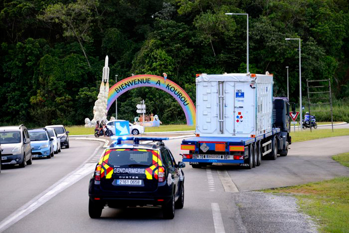
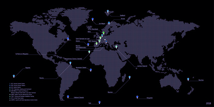
    The U.K. has also bruited blocking Galileo from use of ground tracking stations in British overseas territories, such as the Falklands.

    A U.K. minister stated: “The U.K. genuinely wants to remain a major player in the project, with privileged ongoing access from outside the EU, and views its capabilities and contribution to date as giving it the right to that ticket.”

    A European spokesperson countered: “For the EU, the decision to leave inevitably entails relegation to a different role and status in the project, and, let’s be candid, offers scope for EU-located firms to take contractual business away from U.K. ones.”

    Oh, what a tangled web these mortals weave.

  • SES provides managed services for Galileo navigation system

    SES provides managed services for Galileo navigation system

    From left: Ruy Pinto, chief information officer, deputy chief technology officer of SES; André Bauerhin, COO, Spaceopal; Nicole Robinson, SVP Global Government at SES Networks; Etienne Schneider, Luxembourg Deputy Prime Minister, Minister of the Economy. (Photo: SES)

    SES will provide a series of services for the Galileo European navigation system under a long-term agreement with Spaceopal, a joint venture between Telespazio and DLR GfR mbH. According to SES, the contract is part of the Galileo Service Operator framework agreement between Spaceopal and the European Global Navigation Satellite System Agency.

    Under the agreement, SES will provide Spaceopal with services to support the maintenance and operations of the Galileo Global Navigation Satellite System. Further, SES will be responsible for in-orbit measurements for the Galileo satellite constellation and provide VSAT managed services to Telespazio for the Galileo Data Dissemination Network.

    “We are delighted to extend our partnership with SES in the framework of the Galileo Service Operator contract with the European Global Navigation Satellite Systems Agency,” said André Bauerhin, COO of Spaceopal. “SES’s previous success with the Galileo project in delivering and managing services for both in-orbit testing and the Galileo Data Dissemination Network has made SES the clear choice for this operational contract.”

    SES also looks forward to the partnership.

    “We are proud that we can continue to draw on the experience that we have accumulated while working on Galileo over the years, and continue to be part of the team in ensuring the reliability of the GNSS system and accommodating its shifting demands in the next decade,” said Nicole Robinson, SVP Global Government at SES Networks.

    Previously, SES has provided infrastructure and services for the Galileo program, as well as ground stations and in-orbit testing during the In-Orbit Validation Phase.

  • Dual-frequency GNSS smartphone hits the market

    Dual-frequency GNSS smartphone hits the market

    Mobile brand Xiaomi has launched a dual-frequency GNSS smartphone.

    Fitted with a Broadcom BCM47755 chip, the Xiaomi Mi 8 provides up to decimeter-level accuracy for location-based services and vehicle navigation, the company said.

    The Mi 8 smartphone represents a breakthrough in GNSS technology as the first commercial deployment of Broadcom’s dual-frequency BCM47755 chip designed for the mass market and introduced in September 2017.

    Until now, mobile location-based applications have been powered by single-frequency GNSS receivers whose location accuracy is limited to a few meters. However, in recent years GNSS systems have been launching satellites broadcasting signals on new frequencies to open up new possibilities. Specifically, Galileo has the majority of satellites with E1/L1 and E5/L5 frequency capabilities.

    The E1/L1 + E5/L5 GNSS chip can compute location with an accuracy of up to a few decimeters.

    Leveraging Galileo for increased accuracy

    According to the company, users of the Xiaomi Mi 8 and future models with dual-frequency GNSS will benefit from better positioning and navigation experience in urban environments. This is due to the unique shape of the E5/L5 frequency, which makes it easier to distinguish real signals from the ones reflected by buildings, reducing the multipath effect, a major source of navigation error in cities and other challenging environments.

    The numerous Galileo satellites broadcasting E5 make this improvement available for users all around the world. In addition, the simultaneous use of two frequencies reduces other sources of error, such as those due to the ionosphere, and the frequency diversity is more robust to interference and jamming.

    In addition to making existing applications more accurate, the enhanced position precision offered by dual-frequency GNSS will also create opportunities for new applications in areas such as augmented reality, vehicle navigation and mapping.

    Commenting on the product launch, European GNSS Agency (GSA) head of market development Gian Gherardo Calini said that the arrival of the first dual-frequency GNSS smartphone to the mass-market represents a breakthrough for users all over the world.

    “The enhanced accuracy provided will empower developers to create new applications that meet the growing high-accuracy location requirements of users and also open up applications that previously only ran in dedicated devices intended for professional use,” Calini said.

    “Broadcom is glad to gear up Xiaomi’s flagship smartphones with the very latest dual-frequency GNSS technology,” added Alex Chou, vice president of product marketing for the Wireless Communications and Connectivity Division at Broadcom. “Xiaomi Mi 8, the world’s first smartphone with BCM47755, will take smartphone GNSS navigation to a whole new performance level.”

    ”The importance of GNSS to modern life is undisputed, and is particularly important for smartphones,” said Zhiyuan Zang, Xiaomi’s director of product marketing. “Navigation and LBS-based apps these days require greater positioning accuracy to work effectively, and dual-frequency GNSS is the key to delivering a great user experience when using these apps. Xiaomi is delighted and honored to be the world’s first smartphone manufacturer to support dual-frequency GNSS. We will continue to pursue innovation for everyone to enjoy.”

    Access to raw measurements for geolocation

    The launch of the first dual-frequency GNSS smartphone, together with the opportunities offered by the availability of GNSS raw measurements in Android, creates exciting opportunities for the geolocation community, the company said.

    Access to raw measurements opens the door to algorithms once restricted to more advanced GNSS receivers. This, in turn, allows users to fully benefit from the differentiators offered by Galileo.

    Recognizing these opportunities, in 2017 the GSA engaged with academia and industry in the areas of navigation and positioning to innovate around this new feature as part of a GNSS Raw Measurements Task Force.

    Then, in January, the GSA published a white paper on the use of GNSS Raw Measurements in Android, providing developers with in-depth information on accessing and using raw measurements to implement advanced GNSS techniques in mass-market devices.

    Building on this work, the GSA and the Raw Measurements Taskforce shared their latest updates at a dedicated workshop — “GNSS Raw Measurements: From Research to Commercial Use” — held at the GSA headquarters in Prague on May 30, where Broadcom presented its encouraging test results from the dual-frequency BCM47755.

  • UN satnav specialists tour ESA’s GNSS facilities

    UN satnav specialists tour ESA’s GNSS facilities

    Delegates from the UN’s International Committee Global Navigation Systems (UN ICG) at the entrance to ESA’s ESTEC Test Centre, used to test the last 22 Galileo satellites. (Photo: ESA)

    The UN ICG group visited ESTEC on May 16 during a meeting in the Netherlands.

    News from the European Space Agency (ESA)

    Members of the United Nations (UN) technical group supporting global cooperation in satellite navigation toured ESA’s technical centre in the Netherlands to see key facilities used to develop Europe’s Galileo system.

    Delegates from the UN’s International Committee on Global Navigation Systems (UN ICG) met in mid-May at the nearby Galileo Reference Centre, operated by the GSA, European Global Navigation Satellite Systems Agency.

    ESA, one of the founding members of the ICG in 2005, invited them to visit the agency’s European Space Research and Technology Centre, ESA’s single largest establishment and home to its Navigation Directorate.

    Javier Benedicto, ESA’s Galileo program manager was joined by Rodrigo Da Costa, GSA’s Head of Exploitation, in giving the visitors a hearty welcome. “I’m honored to work with the amazing team of engineers and managers responsible for developing the Galileo system,” Benedicto said. “The laboratory and testing facilities here are very much at the heart of Galileo development.”

    ESA’s Receiver Testing Facility is the historic location of the first Galileo positioning fix in 2012. (Photo: ESA)

    “I’m very happy to welcome members of the UN ICG group, doing a great job in bringing navigation satellite system operators together, to share achievements and challenges and encourage interoperability – our users love our systems working together.”

    The tour began at ESA’s Receiver Testing Facility — historic location of the world’s very first Galileo positioning fix back in 2012 – equipped with a multitude of specialized satnav receivers for not only Galileo satellites but also the US GPS, Russian Glonass, Chinese BeiDou, India’s NAVIC and Japanese QZSS systems, together with augmentation systems such as Europe’s own European Geostationary Navigation Service, EGNOS. The signals from all these systems can also be recorded to very high fidelity for subsequent investigation or reuse.

    Lab simulation systems can recreate all these outputs in combination to test receiver systems across a huge range of scenarios, such as amid interference induced by a solar storm, or to see how receivers cope while flying, or even in orbit.

    Smartphone receivers can be assessed with simulated augmentation from cellular network stations, wifi mapping or inertial navigation, while simulating their user’s continuous motion. The flexibility the facility’s simulators offer also allows early testing of enhancements planned for next decade’s ‘Galileo Second Generation’ satellites.

    “Our aim is to go closer to the market, and how they’re doing things because how current services are being exploited is very important for developing the next generation,” said Olivier Smeyers of ESA’s Commercial User Segment Section.

    This table in ESA’s Galileo Payload Laboratory comprises a replica Galileo In-Orbit Validation satellite payload (other than its atomic clocks, which are housed separately nearby). Kept in cleanroom conditions at ESTEC in the Netherlands, it is employed for ground-based testing or anomaly investigation. (Photo: ESA)

    Next came the Galileo Processing Centre, which provides ESA with continuous monitoring of Galileo services. It functions independently from the rest of the global Galileo infrastructure, to allow independent assessment of its performance, down to individual satellites and the onboard atomic clocks at the heart of the system — working closely with facilities such as the Galileo Time Validation Facility in Spain and the Galileo Control Centres in Germany and Italy.

    The group was also shown ESA’s Time and Metrology Facility: an ensemble of six high-performance atomic clocks sufficiently stable to monitor the nanosecond-scale performance of Galileo System Time, and since 2012 maintaining their own timescale called UTC (ESTC), employed in turn to help set Coordinated Universal Time (UTC) — the world’s global time.

    The cleanroom environment of the Galileo Payload Laboratory contains the same atomic clocks flown aboard Galileo satellites with the rest of its navigation payload, used to replicate any performance anomalies identified in orbit and make early tests of Galileo Second Generation design improvements.

    The tour proceeded to view ESA’s two Telecommunications and Navigation Testbed Vehicles and the Test Centre where the most recent 22 satellites were cleared for launch.

    “ESA is a very active member of UN ICG,” commented Rafael Lucas Rodriguez of ESA’s Galileo Services Engineering Unit and tour organizer. “We’re currently co-chairing an ICG working group on system performance enhancement and supporting the European Commission and GSA on all Galileo-related technical matters discussed at the committee.”

    An aerial view of ESTEC. The Erasmus building is at front right. The T building (home to ESA’s Galileo team) is in the foreground.
  • Orolia to supply clocks for 12 more Galileo satellites

    Orolia to supply clocks for 12 more Galileo satellites

    Orolia’s atomic clock solutions have been selected for the Galileo Global Navigation Satellite System (GNSS) under contracts totaling 26 million euros for an additional 12 Galileo satellites.

    This latest initiative builds on Orolia’s long-standing role in providing precise timing technology for satellite programs, including Galileo.

    Each satellite will carry two rubidium atomic clocks and two passive hydrogen masers, considered the most stable clock in the world. Under these contracts, Orolia will supply its Spectratime Rubidium Atomic Frequency Standard and its passive hydrogen masers physics package.

    Orolia's Space Rubidium Atomic Frequency Standard. (Photo: Orolia)
    Orolia’s Space Rubidium Atomic Frequency Standard. (Photo: Orolia)

    “We’re honored to continue supporting the European Commission with precise timing for Galileo,” said Orolia CEO Jean-Yves Courtois. “These new contracts further emphasize Orolia’s position as the world’s leading provider of resilient positioning, timing and navigation (PNT) solutions.”

    In addition to serving as Europe’s independent PNT source, Galileo can also serve as a secondary signal source for systems such as GPS, GLONASS or BeiDou in the event of service disruption. Galileo’s quadruple clock redundancy designed into each satellite ensures that even if a failure occurs, overall system performance will not be compromised.

    More than 150 Orolia Spectratime atomic clocks are flying to support Galileo, IRNSS, BeiDou, GAIA and other missions, some for more than 10 years. Orolia provides the expertise necessary to design solutions for highly reliable space applications.

    Orolia is a designer and manufacturer of a full range of high-performance, low-cost GNSS synchronized crystal solutions, rubidium and maser sources, smart integrated GNSS reference clocks, rugged PNT devices, GNSS simulation and clock testing systems. Orolia’s PNT solutions support a variety of critical applications including defense, government, space, maritime, enterprise networks, aviation and telecommunications.

  • Yet Another GNSS — Now for the UK

    Yet Another GNSS — Now for the UK

    The United Kingdom and the European Union (EU) continue locked in conflict over Galileo post-Brexit, much akin to a divorce dispute over the children.

    The European Commission has initiated proceedings to exclude the U.K. and its companies from security work on Galileo before the country’s exit from the bloc next year, a move that presages exclusion from use of the security features of the Galileo PRS signal.

    The U.K. has responded with a demand for repayment of up to 1 billion pounds ($1.34 billion).

    Both sides say they wish to continue working together on the GNSS, but the EU insists that it must be under new rules, including those preventing third countries from obtaining access to critical security information. The European Commission, executive arm of the EU, says the U.K. can no longer be trusted with sensitive data providing a secure back-up for the new satellite system.

    “It’s simple: Britain is part of Galileo today as an EU member, but won’t be automatically part of Galileo tomorrow as a third-party state,” said an EU advisor. “That’s the mechanical, legal consequence of Brexit.”

    The U.K. for its part has made unrestricted access a condition for a broader security collaboration.

    There has been speculation that the U.K. would use the $1.34 billion alimony settlement to build a new GNSS, drawing on expertise from Australia — in effect, engendering offspring from a new marriage.

  • Galileo pair arrive at spaceport for July launch

    Galileo pair arrive at spaceport for July launch

    News from the European Space Agency

    The next two satellites in Europe’s Galileo satellite navigation system have arrived at Europe’s Spaceport in Kourou, French Guiana, ahead of their planned launch from the jungle space base in July.

    Galileo satellites 23 and 24 left Luxembourg Airport on a Boeing 747 cargo jet on the morning of May 4, arriving at Cayenne – Félix Eboué Airport in French Guiana that evening.

    Arrival at the Felix Eboué airport on April 5, 2018. (Photo: ESA)
    Arrival at the Felix Eboué airport on April 5, 2018. (Photo: ESA)

    They were then unloaded, still in their protective air-conditioned containers, and transported by truck to the cleanroom environment of the preparation building within Europe’s Spaceport.

    This pair will be launched along with another two Galileo satellites, which are due to be transported to French Guiana later this month.

    The quartet will be launched together on a customized Ariane 5 on July 25.

    The Galileo System began Initial Services on Dec. 15, 2016, and a growing number of commercial devices are using Galileo today. Completion of the constellation should improve Galileo’s positioning accuracy further still.

    One of two Galileo satellites being driven by truck to the Guiana Space Centre inside its container. Galileo satellites 23 and 24 left Luxembourg Airport on a Boeing 747 cargo jet on the morning of May 4, arriving at Cayenne – Félix Eboué Airport in French Guiana that evening. (Photo: ESA)

    But Galileo satellites will continue to be launched into the future: a further 12 Galileo “Batch 3” satellites were ordered last June, supplementing the 26 built so far to provide further in-orbit spares, and replacements for the oldest Galileo satellites, first launched in 2011.

    A steady stream of orbital spares, ready to replace satellites reaching the end of their operational lives, is essential to ensure Galileo continues operating seamlessly.

    Looking further ahead, with the aim of keeping Galileo services as a permanent part of the European and global landscape, replacement satellites will be required by the middle of the next decade, offering improved performance and added features.

  • Harxon exhibits positioning, data-transmission tech at AUVSI Xponential

    Harxon exhibits positioning, data-transmission tech at AUVSI Xponential

    Harxon showcased high-precision positioning GNSS antennas and its latest wireless data-transmission technologies for UAV applications at AUVSI Xponential, which was held April 30-May 4 in Denver.

    The Harxon D-Helix Antenna.

    Harxon’s D-Helix is a patented D-QHA (dual-quadrifilar helix antenna) multi-constellation antenna supports excellent reception of GPS, Galileo, BeiDou and GLONASS, as well as L-band signals. Harxon D-QHA technology ensures the ability of low elevation satellites tracking while maintaining 4-dBi high gain, which makes the D-Helix antenna an excellent choice for any applications where the sky is partially visible, the company said.

    The antenna’s low noise amplifier (LNA) with out-of-band rejection performance can suppress electromagnetic interference. Moreover, the D-Helix features the latest low wind resistance design with ruggedized IP67 protection for UAV inspection and monitoring, survey and mapping or agricultural UAVs.

    Photo: Harxon
    Photo: Harxon

    The HX-DU2017D is a 5-gram frequency-hopping OEM transceiver supporting frequencies between 840 MHz and 900 MHz. It provides strong anti-jamming and signal receiving capability for complex data intensive applications. Its full duplex mode ensures data secure transmission, more stable long-range communication and short latency of data transmission.


    Watch this video to learn more about the HX-DU2017D.


    Other showcased Harxon GNSS products, such as Helix Antenna HX-CH7603A, HX-CH4601A and HX-CH6601A, are all featured with patented D-QHA technology. Moreover, the showcased Survey Antenna GPS 500, OEM Modem HX-DU1018D and Smart Antenna are also appropriate for surveying and mapping, as well as precision agriculture.

    Photo: Harxon
    Photo: Harxon
  • System of Systems: The long life of GPS III

    System of Systems: The long life of GPS III

    Late Breaking: Ligado

    On April 26, the U.S. Department of Transportation publicly released the long-awaited GPS Adjacent Band Compatibility Assessment. See the June issue of GPS World for an expert and measured analysis of this highly impactful document.

    The article will be posted online when it becomes available in mid-to-late May.


    Merger Mystery

    Contrary to the “Out in Front” editorial published in the April issue of GPS World magazine, there was an Izvestia story published on March 28 touting a merger of the GLONASS and BeiDou systems, and there will be an International Conference on Advanced Technologies in Manufacturing and Materials Engineering in Harbin, China, at which such a possibility may hypothetically be discussed.

    However, neither hard news nor any official statements have emerged to substantiate such a dubious claim, despite repeated queries to officials of both countries.

    Javad Ashjaee (far left, above), CEO of JAVAD GNSS and based in Moscow, communicated that he spoke on a panel at an aerospace technology event organized by the American Chamber of Commerce in Russia, alongside representatives from NASA, Boeing, Honeywell and Roskosmos.

    Ashjaee asked the Roskosmos official publicly about the prospect of a GLONASS merger with BeiDou, and “he knew nothing.”


    Diverger Dilemma

    As this magazine goes to press, stories emerge of a U.K. plan to launch a satellite-navigation system separate from the European Union’s Galileo project. This comes in response to an EU statement that the UK would be shut out of key elements of the European satnav program, particularly the Public Regulated Service, after Brexit.

    Historically, in the late 1980s or early 90s the UK drew up plans for its own GNSS prior to the launch of Galileo. And UK-based Surrey Satellite Technology Ltd. built all operational Galileo payloads to date. So the country clearly has the capability. That SSTL is currently owned by Airbus (either German or Dutch division) may or may not constitute a wrinkle.

    Finally, the UK spent 1.4 billion euros on Galileo, and may now file for a refund.


    The Long Life of GPS III

    By Robin Wrinn, Contributing Author

    GPS III SV01 in electromagnetic interference, compatibility and passive intermodulation testing. (Photo: Lockheed Martin)

    During interviews with Lockheed Martin and Harris Corporation at the 34th Space Symposium, time and space were a frequent focus of discussion, but not in the normal “continuum” kind of way.

    Greater mission longevity is one of the key improvements GPS III delivers over those currently in service. Space Vehicles 1–10 have a planned mission life of about 15 years, 25 percent longer than their predecessors. Yet that begs the question “How long should a satellite live in space, with technology innovation occurring almost annually?”

    Advanced payload technology provides a partial answer to that question. Both Lockheed Martin and Harris Corporation highlighted new payload capabilities with built-in flexibility to adapt satellites in orbit to technology advances, as well as changes in missions.

    Lockheed Martin provided the media a tour of their Radio Frequency Payload Center of Excellence. Meanwhile, Harris recently announced completion of the fully digital Mission Data Unit (MDU), core to the navigation payload for GPS III 11 +. As a reminder, the current Harris payload for SVs 1–10 includes:

    • greater than three times reduction in range error,
    • up to eight times increase in anti-jamming power,
    • added signals, including L1C, compatible with other GNSS such as Galileo, and
    • greater signal integrity.

    According to Harris, the fully digital navigation payload will provide the ability to change and upgrade the satellites incrementally over mission life.

    Meanwhile, Lockheed announced a partnership with NEC to introduce artificial intelligence for computer learning in orbit. The company’s Payload Center experts touted significant advances in processers and a move toward next-generation antennas, arrays and transmitters to drive more satellite flexibility, capability and resilience.

    Observation: The market pressures of ‘new space’ players is prompting delivery of products that can drive more value for less cost. In this case, delivery of a common payload architecture and electronically steered beams to make satellite antennas become any shape you want. Most likely, beams of a different size on demand is a much better business case than a static one built five years ago.

    The day I interviewed Lockheed Martin’s Navigation Systems mission area Program Manager Johnathon Caldwell, the company had submitted its proposal for the U.S. Air Force’s GPS III Follow On (GPS IIIF) program. That same day, April 16, the media was given a tour of Lockheed Martin’s GPS III satellite assembly floor. It was clear from both Lockheed’s press materials and Caldwell that Lockheed Martin believes it is fully recovered from prior production hiccups and is

    • on track to deliver GPS Space Vehicles (SVs) 1 through 10, and
    • deserves to win the bid for GPS IIIF. Now that both Boeing and Northrop Grumman have dropped out of the running, Lockheed is virtually assured the contract. The government has said it will announce the award in March 2019.

    For an update on GPS III space vehicles 1–10, see the full version of this article.

    Harris Corporation Interview

    with Jason Hendrix, PNT Program Director

    What are the differences in the GPS III satellite payloads that were instituted to enable the new signals?

    The main difference is the power. The Air Force’s requirements called for significantly more anti-jamming capability. All the transmitters are a higher power.

    What was the most significant obstacle (or top obstacles, plural) in designing and manufacturing this new payload, to new Air Force specifications? How did you overcome it/them?

    Same answer really, the higher power. Keeping in mind, we went from a 7-year mission life requirement to a 15 year. That higher power puts more strain on components and new cyber requirements in software. When you couple all that together we are not just upgrading payload technology. It is really engineering a new set of payload requirements. It’s new generation, advanced.

    What are the advantages of a digital payload over the alternative?

    The advantages and the 30 percent difference are the timekeeping system portion. We’re moving from a manual, analog timing to digital to deliver to the Air Force more flexibility. It’s a nice option to have to be able to reprogram in orbit and maybe enhance capabilities desired in the future.

    For more from Harris, see longer version.

    Interview with Lockheed Martin

    with Johnathon Caldwell, Navigation Systems Mission Area Program Manager

    Any changes in your production approach having completed SV01?

    No, the performance on Vehicle 01 was as designed there were no technical or design changes necessitated throughout the rest of the fleet. So, it was a very successful from that perspective — from the standpoint of validating the design and wringing it out, Vehicle 01 served its purpose well.

    It had a very good T-Vac. I would say overall when you look at the industry, Vehicles 01–02, our vacuum test campaigns are the most rigorous test. Both went through their tests quite well. Some of the best I’ve seen.

    For more from Lockheed Martin, see longer version.

  • Satellites Leadership Award presented to Wolfgang Paetsch

    For his leadership in setting up the routine production of the Galileo satellites leading to Galileo constellation deployment, including thequadruple Ariane 5 launch in November 2016, Wolfgang Paetsch was named the winner of the 2017 Satellites Leadership Award. Since he was unable to attend, Paul Verhoef, director of the Galileo Programme, accepted the award on his behalf at the GPS World Leadership Awards dinner. The award was presented by Rob Scott from Rockwell Collins, a co-sponsor of GPS World’s Leadership Dinner and Awards Ceremony.

  • GSA, Joint Research Centre test automotive eCall with Spirent

    Spirent Communications plc is working with the European Commission’s Joint Research Centre (JRC) to help implement the eCall system, which is required in new cars sold in Europe starting in April.

    Experts from the JRC have been working with Spirent GNSS test equipment during the European GNSS Agency (GSA) eCall test campaign. The campaign aims to pre-test eCall in-vehicle modules and evaluate their compatibility with the positioning services provided by Galileo and the European Geostationary Navigation Overlay Service (EGNOS) in accordance with the test procedures established by the regulation.

    As the eCall initiative goes live this month, the GSA launched a test initiative to support eCall device manufacturers in their preparation for type approval. In safety-critical situations, eCall must be as accurate as possible, so defining and conducting proper test procedures is imperative.

    Spirent is cooperating with the JRC to develop its own eCall test solution. “Working with JRC enabled us to develop better tests to verify that eCall devices are working properly,” said Steve Hickling, product director for Spirent’s positioning business.

    When a collision occurs, an eCall-equipped car automatically calls the nearest emergency centre. Even if no passenger is able to speak – such as because of injuries — a “minimum set of data” is sent, which includes the exact location of the crash site. eCall is expected to significantly reduce emergency service response times, leading to lives saved and injuries reduced.

    The JRC used a Spirent GSS9000 simulator to assess eCall devices’s capability to support the reception and processing of the Galileo and EGNOS signals. Using feedback from the JRC, Spirent has developed an eCall Test Suite for its automation solution, PT TestBench.

    Tested with various eCall devices, the eCall Test Suite is available for eCall device manufacturers and include, among others, positioning accuracy, time to first fix, GNSS receiver sensitivity and reacquisition performance.

    For more information on Spirent’s GNSS testing solutions, visit the website or download the company’s white paper Detecting and Protecting Against GPS Cyberthreats.

  • Galileo ground segment keeps constellation on track

    Galileo ground segment keeps constellation on track

    News from the European Space Agency

    Galileo’s initial services have been running for more than 15 months now, and signals from the satellites in space are routinely serving users all across the world. The functioning of Galileo is dependent on a global network of ground stations, its current extent shown in the map here.

    The constellation in orbit is only one element of the overall satellite navigation system – the tip of the Galileo iceberg. At the same time as satellites were being built, tested and launched, a global ground segment has been put in place, extending to some of the world’s loneliest places, from Svalbard in the High Arctic to storm-engulfed Jan Mayen Island, Ascension Island in the Mid Atlantic to Noumea in the South Pacific, Kerguelen in the southern Indian Ocean to Troll base in the Antarctic interior.

    Galileo’s global ground segment. (Image: ESA)

    Among the latest developments are updated control and mission software for the two Galileo control centres that sit at the heart of this global web: Fucino in Italy generates the accurate navigation messages that are then broadcast through the navigation payloads, and Oberpfaffenhofen in Germany controls the constellation of satellites. A new telemetry, tracking and command station last year arose in Papeete on Tahiti, in the South Pacific.

    Establishing Galileo’s ground segment was among the most complex developments ever undertaken by ESA, having to fulfill strict levels of performance, security and safety. Formal responsibility for the operations of this Galileo ground segment was last year passed to ESA’s partner organization, the European Global Navigation Satellite System Agency, or GSA, but ESA continues to be in charge of its maintenance and growth.

    Galileo’s Nouméa ground station’s Sensor Station and Uplink Station. (Photo: ESA)

    Users don’t have to worry about this ground segment, but it is essential to keeping Galileo services running reliably. The atomic clocks aboard the satellites are accurate to a few nanoseconds, delivering metre-scale positioning precision, but they are prone to drift over time.

    Similarly, the orbits of the satellites can be slightly nudged by the gravitational tug of Earth’s slight equatorial bulge and by the Moon and Sun. Even the slight but continuous push of sunlight itself can affect satellites in their orbital paths. The quality of signals received on the ground can be affected by their transit through the ever-changing ionosphere, the electrically active outer layer of Earth’s atmosphere.

    Galileo sensor stations, with small omnidirectional receiving antennas around just 50 cm high, are on place around the globe to check the accuracy and signal quality of individual satellites in real time, and work together to pinpoint the current satellite orbits.

    These measurements are transmitted via secure satellite communications to Fucino, where they serve as the basis of a set of corrections — accounting for timing or orbital slips — to be uplinked to the satellites via a network of 3-metre-diameter uplink stations for rebroadcast within navigation messages to users, currently updated every 50 minutes.

    Considering Galileo is Europe’s largest satellite constellation, timely control of the satellites is essential, enabled by 13 m-diameter telemetry, tracking and command stations in Kiruna, Sweden and Redu, Belgium as well as the equator-hugging Kourou, French Guiana, Reunion, Noumea in New Caledonia and now Papeete sites.

    Galileo Station on Gran Canaria. (Photo: ESA)

    The ground segment also comprises a set of four Medium-Earth Orbit Local User Terminals serving Galileo’s search and rescue service, at the corners of Europe and facilities for testing Galileo service quality and security — the Timing and Geodetic Validation Facility and two Galileo Security Monitoring Centres.

    The Launch and Early Operations Control Centres have the task of bringing new satellites to life, to be handed over to the main Satellite Control Centre in Oberpfaffenhofen within typically a week after launch. Redu in Belgium, set up as Galileo’s In-Orbit Test Centre, then puts these satellites through a complex set of testing and checkouts ahead of them joining the working constellation.