The European GNSS Agency (GSA) has officially launched the equipment for dual frequency Galileo, GPS and EGNOS project (EDG²E) with a consortium led by Thales. The four-year project intends to develop a dual-frequency multi-constellation receiver, enabling enhanced navigation capabilities, support standardization and certification preparation, and facilitate the expected increase in air traffic, both in Europe and globally.
The prototype EDG²E receiver use GPS and Galileo signals as well as those from the European SBAS multi-constellation EGNOS. The project aims to achieve a prototype demonstration by 2021. At the end of the EDG²E project, the first SBAS dual-frequency GPS+Galileo receivers for aviation will be ready for final development and use in the aviation sector and in other safety-critical applications. Fully achieved receivers are foreseen to be installed in commercial aircraft by 2025.
EGNOS, certified for use in aviation since February 2011, is developing its own next generation, called EGNOS V3, to further enhance performance by complementing both the EU Galileo and the US GPS satellite navigation constellations.
“EGNOS v3 will provide aviation users with an increased quality of services, better accuracy and extended coverage area among other key performance indicators” said Jean-Marc Pieplu, GSA head of the EGNOS Services Programme. “Fundamental Element Programme is a medium that supports development of terminals and antennae fostering use of E-GNSS in all domains. In this perspective,EDG²E is an important step for GSA as it will contribute to availability of high technology products on the aviation market, taking benefit of Dual Frequency Multi Constellation feature offered by EGNOS v3.”
The consortium includes Thales, Thales Alenia Space and ATR, as well as contributions from Dassault Aviation and the French Civil Aviation Authority.
Feature image courtesy of the European Space Agency (ESA).
A U.K. government report issued on Jan. 30 looks at the vulnerability of all satellite-based positioning systems: GPS, Galileo, GLONASS, BeiDou, QZSS and more. Issued by the Office of the Government Chief Scientific Adviser, Sir Mark Walport, and informally called the Blackett Report, designating the highest level of government scientific studies, named after a UK physicist who won the 1948 Nobel Prize, the review aims to “lay out the breadth, scale and implications of our reliance on ‘the invisible utility’ mainly in terms of existing critical national infrastructure (CNI).”
“Satellite-derived Time and Position: A Study of Critical Dependencies” states in the forward that it “represents a vital step in understanding the UK’s dependency on GNSS and recommends measures to improve our resilience. Importantly, it also recognises that innovation will be key to realising, fully and safely, the economic and societal benefits offered by GNSS.”
The report points to the fragility of satellite positioning signals which can be affected by cheap jammers, spoofers, weather and interference from other radio signals — among other vulnerabilities. The 86-page PDF document is downloadable here.
The review incorporates the results of a separate but related study, issued in April 2017, looking at the fiscal consequences of a GNSS disruption in. “Economic Impact to the U.K. of a Disruption in GNSS” was briefly summarized in a June 2017 column from this magazine (scroll down to “At What Cost Ignorance?”). The report attempted to quantify the cost of a GNSS disruption, should one occur. The authors came up a figure of 5.2 billion pounds ($6 billion) for a 5-day disruption.
David Last, a UK consultant engineer specializing in radio navigation and communications systems, professor emeritus at the University of Bangor, Wales and past president of the Royal Institute of Navigation, consulted on the June 2017 economic impact report, and was a member of the expert panel and co-author of the January 2018 Blackett Report. He was to have given a presentation on them at the ION International Technical Meeting in Reston, Virginia on January, but could not make the trip. The following materials are drawn from his prepared presentation.
Some of the conclusions from the June 2017 economic impact study are:
There are alternatives to GNSS, specific to each application
However, there is no universally-applicable single alternative for positioning and navigation
Among the most salient needs: higher quality (more expensive) oscillators for timing
“The most applicable mitigation strategies for the largest number of applications are eLoran and Satelles.”
“Omnisense and Locata may be preferred for localised applications that require high levels of accuracy.”
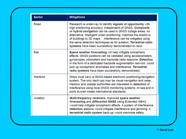
From the just-issued Blackett Report, the first figure displayed above presents recommended mitigations to impacts on GNSS applications in road, rail, maritime and aviation. Alternative options include composite or hybrid navigation, terrestrial radio systems, space weather forecasting, eLoran, various methods of interference detection, multi-frequency receivers and differential GNSS.
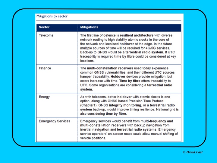
A second figure from Last’s presentation, shown above, covers the mitigations recommended for telecoms, finance, energy, and emergency services sectors. Mitigations for these applications include a resilient architecture with diverse network routing to high-stability atomic clocks, terrestrial radio systems, time-by-fiberoptics, multiconstellation receivers, holdover devices, GNSS integrity monitoring, and inertial navigation.
Concluding recommendations of the Blackett Report:
CNI operators to review and report on their reliance on GNSS. Cabinet Office to assess overall dependence of CNI on GNSS.
Add loss or compromise of GNSS-derived PNT to National Risk Assessment, not just as a dimension of space weather.
In allocating radio spectrum to new services and applications, address the risk of interference to GNSS-dependent users, including CNI.
Review the legality of the sale, ownership and use of devices and software to cause deliberate interference to GNSS receivers or signals.
Assess the need to monitor interference of GNSS at key sites such as ports and share the data with government
Employ GNSS-independent back-up systems.
Cross-government PNT Working Group to report to Cabinet Office on ways to improve national resilience.
Government to facilitate as those procuring GNSS equipment for CNI specify performance standards.
Map PNT testing facilities and explore how industry and critical services can better access them.
Leverage UK academic and industrial expertise in time and geo-location, increasing coordination among existing centres of excellence.
EGNOS V3 will offer improved and secure Civil Aviation Safety of Life services for the next decade over Europe. The program will ensure a full continuity of service and will be the first operational SBAS using both GPS and Galileo.
Airbus has been selected by the European Space Agency (ESA) as the prime contractor to develop EGNOS V3, the next generation of the European Satellite Based Augmentation System (SBAS) planned to provide the civil aviation community with advanced safety-of-life services and new services to maritime and land users.
Developed by ESA on behalf of the European Commission and the European GNSS Agency (GSA), EGNOS V3 (European Geostationary Navigation Overlay Service) will provide augmented operational safety-of-life services over Europe that improve the accuracy and availability of user positioning services from existing GNSS (Galileo and GPS).
EGNOS also provides crucial integrity messages to EGNOS users with alerts within a few seconds in case of system degradation, consolidating EGNOS’ position as one of the leading edge GNSS systems in the future.
Besides improved safety-of-life services, EGNOS V3 will improve robustness against increasing security risk, in particular cyber-security risks.
EGNOS V3 will ensure a full continuity of service for the next decade and will be the first operational SBAS implementing the dual-frequency and multi-constellation world standard, with both GPS and Galileo, replacing EGNOS V2 which has been in operation since 2011.
“This programme is strategic for Airbus to strengthen our position in the Navigation field. The signature of this contract is the result of more than 5 years of intense team work and investment,” said Nicolas Chamussy, head of Space Systems at Airbus. “With our consortium, we bring a large pool of resources and experience in Europe covering the successful development of critical and secure ground segment. I am confident that we will make EGNOS V3 a success story.”
As prime contractor, Airbus will be leading a consortium with partners from France, Germany, Spain and Switzerland. Airbus will be responsible for the development, integration, deployment and preparation of EGNOS V3 operations, the overall performance of the system and the Central Processing Facility, which is the heart of the real-time navigation algorithms.
During the 6.5-year contract, around 100 people and 20 subcontractors will work on delivering the EGNOS V3 system. In 2023, the single-frequency version will be available to replace the current operational version and, 18 months later, the final version in dual frequency will be delivered.
EGNOS is composed of a large network of about 50 ground stations deployed over Europe, Africa and North America, two master control centers near Rome and Madrid, and a System Operation Support Centre in Toulouse. EGNOS will also use geostationary satellite navigation payloads.
The European Space Agency (ESA) held its annual Navigation Days on Jan. 26. ESA navigation specialists met with guests from the European Commission, European Global Navigation Satellite Systems Agency and European space companies at ESA’s technical centre in the Netherlands.
With Europe’s Galileo satellite navigation system only one launch away from full global coverage, representatives of the European space industry gathered at ESA’s centre in the Netherlands to discuss the transition towards the future Galileo Second Generation.
Galileo Initial Services began on Dec. 15, 2016, while the constellation in orbit has grown to 22 satellites. An Ariane 5 launch later this year of another quartet will bring the constellation to the point of completion with 24 satellites, plus two orbital spares.
A steady stream of orbital spares, ready to replace satellites reaching the end of their operational lives, is necessary to ensure Galileo continues operating seamlessly. A further 12 satellites were therefore ordered from industry in June 2017.
Paul Verhoef, director of the Galileo Programme addresses the audience at ESA’s annual Navigation Days, held Jan. 26. (Photo: ESA)
Looking further ahead, with the aim of keeping Galileo services as a permanent part of the European and global landscape, a replacement set of Galileo satellites will be required post-2020, serving as transition to a future generation.
The Galileo Second Generation is foreseen to offer improved performance and added features. This is why the European Commission has decided on a Transition Programme, with the European Space Agency (ESA) in charge of its technical definition and implementation.
Together with the European Commission and the European Global Navigation Satellite System Agency, the agency invited leading European space companies to its technical centre in Noordwijk for Navigation Days, held Jan. 26, to discuss Galileo’s future and present short-term plans in relation to this transition programme.
Having started with the ESA European Global Navigation Satellite System Evolutions Programme (EGEP), the system and technology development of Galileo Second Generation is being supported through the EU’s GNSS and Horizon 2020 HSNAV Programmes, with ESA being delegated its technical definition and management of its related implementation.
Eleven Phase-B contracts were signed at the meeting for the Design Phase for both the Galileo Second Generation and the Transition Programme, complementing the more than 50 technology contracts signed in 2017 to prepare for Galileo’s future.
In recent years, innovations have been analysed and predevelopments performed in various technology fields (system, ground, space, receiver technologies) in order to assess their suitability for future Galileo activities, while ensuring backward compatibility and continuity of Galileo Services.
In the next eight months, all major public and private stakeholders will be involved in the detailed assessment of the different evolution scenarios and associated technologies, in order to come to decisions on the Transition Programme baseline for the evolution towards Galileo Second Generation.
A security center for the European Union’s Galileo satellite system will be moved from the United Kingdom to Spain as a result of Brexit, according to numerous press reports.
A committee of representatives of member states voted by a large majority on Jan. 18 to approve the European Commission’s recommendation of Madrid as the Galileo Security Monitoring Centre’s (GSMC’s) new home.
The center, which is not yet fully operational, has only one full-time member of staff in Swanwick, England, but when it is up and running in Madrid, staffing is expected to grow to as many as 30.
The center controls access to the satellite system and provides around-the-clock monitoring when the main security center near Paris is offline.
The European Commission’s decision to move the center to Spain will bring Spain “strategic advantages, industrial development of high technological value, and the consolidation of national knowledge and technology in the area of security,” the Spanish ministry of public works said.
Spain was selected from six countries, according to Spanish media. It offers the facilities of the National Institute of Aerospace Technology (INTA), which belong to the defense ministry and are located in Madrid.
The GSMC is operated by the European GNSS Agency (GSA) in charge of supervising and acting on cases such as security threats and alerts.
Spain has another of the fundamental centers of the program, the Loyola de Palacio GNSS Service Center, also located in Madrid.
The center is one of a number of EU institutions leaving the UK as a result of the 2016 referendum vote, also including the European Banking Agency, which is relocating to Paris, and the European Medicines Agency, which is going to Amsterdam.
Liftoff of Ariane 5 Flight VA240 from Europe’s Spaceport in Kourou took place at 18:36 UTC on Dec. 12, 2017, carrying Galileo satellites 19–22. (Photo: ESA)
On Dec. 12, four more Galileo satellites headed into space to join the navigation constellation. Galileos 19–22 lifted off aboard an Ariane 5 rocket from Europe’s Spaceport in Kourou, French Guiana, at 18:36 UTC (19:36 CET, 15:36 local time).
After today’s successful launch, only one more launch remains before the Galileo constellation is complete and delivering global coverage.
Separation of the upper stage occurred about nine minutes after liftoff, followed by the first firing of the upper stage.
The first pair of 715-kg satellites was released almost 3 hours 36 minutes after liftoff, while the second pair separated 20 minutes later.
They were released into their target 22,922 km-altitude orbit by the dispenser atop the Ariane 5 upper stage. In the coming days, this quartet will be steered into their final working orbits. There, they will begin around six months of tests — performed by the European Global Navigation Satellite System Agency (GSA) — to check they are ready to join the working Galileo constellation.
This mission brings the Galileo system to 22 satellites. Initial Services began almost a year ago, on Dec. 15, 2016.
“Today’s launch is another great achievement, taking us within one step of completing the constellation,” remarked Jan Wörner, ESA’s director general.
“It is a great achievement of our industrial partners OHB (DE) and SSTL (GB) for the satellites, as well as Thales-Alenia-Space (FR, IT) and Airbus Defense and Space (GB, FR) for the ground segment and all their subcontractors throughout Europe, that Europe now has a formidable global satellite navigation system with remarkable performance.”
Paul Verhoef, ESA’s director of navigation, added, “ESA is the design agent, system engineer and procurement agent of Galileo on behalf of the European Commission. Galileo is now an operating reality, so, in July, operational oversight of the system was passed to the GSA.
“Accordingly, GSA took control of these satellites as soon as they separated from their launcher, with ESA maintaining an advisory role. This productive partnership will continue with the next Galileo launch, by Ariane 5 in mid-2018.
“Meanwhile, ESA is also working with the European Commission and GSA on dedicated research and development efforts and system design to begin the procurement of the Galileo Second Generation, along with other future navigation technologies.”
Next year’s launch of another quartet will bring the 24‑satellite Galileo constellation to the point of completion, plus two orbital spares.
Europe’s next four Galileo navigation satellites are in place atop the Ariane 5, ready to be launched Dec. 12.
Liftoff from Europe’s Spaceport in Kourou, French Guiana is scheduled for 18:36 GMT (19:36 CET, 15:36 local time), carrying Galileo satellites 19–22.
Four Galileo satellites seen before being encapsulated by the protective payload fairing on Dec. 7, completing the Ariane 5 for flight VA240, scheduled for Dec. 12.
Completion of Galileo’s Ariane 5 rocket took place in the Spaceport’s Final Assembly Building, following the arrival there of the quartet of satellites, already attached to the dispenser that will hold them in position during launch, then release them into their target 22 922 km-altitude orbit
Next, the satellites plus dispenser were placed atop the Ariane 5’s upper stage, after which the 14 m-long protective fairing was lowered over the Galileos — the last time they will be seen by human eyes. This fairing will protect them from the onrushing atmosphere during ascent.
The next step will be Monday’s rollout to the launch zone.
This mission will bring the Galileo system to 22 satellites. Initial Services began almost a year ago, on Dec. 15, 2016.
Next year’s launch of another quartet will bring the constellation of 24 satellites to completion, plus two orbital spares.
Galileo is Europe’s civil global satellite navigation system. It will allow users worldwide to know their exact position in time and space with great precision and reliability.
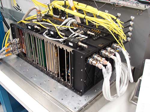
The fully digital Mission Data Unit (MDU) will create precise civil and military timing navigation signals for GPS III satellites 11 and beyond. Pictured here is the advanced MDU on navigation payloads being delivered for GPS III Space Vehicles 1-10. (Photo: Harris)
Harris Corporation has completed development of its fully digital Mission Data Unit (MDU), which is at the heart of its navigation payload for Lockheed Martin’s GPS III satellites 11 and beyond.
Harris has already provided MDUs and payloads for the first 10 GPS III satellites, one of which has been declared “available for launch” and the second of which is completing its testing. The other eight are in various stages of production assembly.
Payloads for the satellites 11 and beyond bring further signal transmit capabilities, providing more powerful signals and built-in flexibility to adapt to advances in GPS technology, as well as future changes in mission needs.
The new MDU that will eventually go aboard satellites 11+ “can be upgraded incrementally over its mission life due to built-in adaptability,” according to a Harris spokesperson.
GPS OCX
The U.S. Air Force Space and Missile Systems Center has accepted delivery of the GPS Next Generation Operational Control System (GPS OCX) Launch and Checkout System (LCS) baseline from Raytheon Intelligence and Information Systems. Also known as Block 0, LCS demonstrated conformance through test and analysis with all contractual requirements. OCX Block 0 is the foundation for Raytheon’s future Block 1 and 2 delivery, slated for 2022.
LCS is a fully modernized cyber-secure ground system complete with the computing hardware, operations center workstations, and mission application software necessary to launch the first GPS III satellite into orbit and perform initial on-orbit testing.
Mission operators are now using LCS in the GPS III Mission Readiness Campaign. The ground system is performing as expected during the rehearsals and space vehicle checkout.
Galileo Launch
A Galileo satellite undergoes its fit-check validation at the Spaceport. Flight VA240. (Photo: ESA/Arianespace)
As this magazine goes to press, final preparations are underway for Galileo’s quadruple launch on Dec. 12. The Ariane 5 rocket has completed its build-up at the spaceport in French Guiana and is moving toward payload integration and rollout to the launch zone.
The four 700-kilo (1,543-pound) Full Operational Capability (FOC) Galileo satellites have completed checkout and one-by-one verification of their interfaces with the payload dispenser that will release them once aloft in mid-Earth orbit.
They will soon take on fuel for their long space life.
The satellites will bring the Galileo operating constellation to 22, and, according to the European Space Agency, this will provide availability to users anywhere in the world for a high-quality position solution — defined as position dilution of precision (PDOP) less than 5 — 99.8% of the time.
The Ariane 5 for Arianespace’s Dec. 12 year-ending flight for 2017 has completed its initial build-up at the Spaceport in French Guiana — where preparations also are moving ahead with four satellite passengers that will further expand Europe’s Galileo global navigation system once in their final orbit.
During activity in the Spaceport’s Launcher Integration Building, the heavy-lift vehicle for Arianespace Flight VA240 underwent the assembly process that began by mating its two solid propellant strap-on boosters with the main cryogenic stage.
The next step was integration of Ariane 5’s vehicle equipment bay, which serves as the launch vehicle’s “brain,” providing autonomous control during the various mission phases.
It was followed by installation of the EPS storable propellant stage, powered by a reignitable engine that operates with MMH and N2O4 propellants. This differentiates the Ariane 5 ES configuration from Arianespace’s Ariane 5 ECA version, which has a cryogenic upper stage and typically is used on Arianespace missions with telecommunications satellites to geostationary transfer orbits.
Inside the Spaceport’s Launcher Integration Building, Ariane 5’s vehicle equipment bay is lowered atop the core cryogenic stage on Flight VA240’s Ariane 5 ES launcher version (left and center). This cleared the way for installation of the launch vehicle’s EPS storable propellant upper stage (right). (Photo: Arianespace)
After completion of verifications and systems checkout by production prime contractor ArianeGroup, the Ariane 5 ES launch vehicle will be moved to the Spaceport’s Final Assembly Building for payload integration and readiness for rollout to the launch zone.
The mission’s ongoing payload preparations — including checkout and fit-check procedure for each of the four Galileo satellites — took place inside the Spaceport’s S1A processing facility. This involved a one-by-one verification of the spacecraft’s interface with the payload dispenser that will release them into circular orbit during the mission.
After the fit-check procedure in the S1A facility, the four satellites were readied for transfer to the S5 payload preparation center for fueling.
For Ariane 5’s Dec. 12 mission, the heavy-lift vehicle will carry its quartet of Galileo satellites (weighing 700 kg. each) and their dispenser system for a medium-Earth orbit deployment.
A Galileo satellite undergoes its fit-check validation at the Spaceport. Flight VA240. (Photo: Arianespace)
Galileo is the European initiative to develop a global satellite navigation system. Under civilian control, it will offer a guaranteed, high-precision positioning service. As a European Union-funded program, the Galileo constellation will comprise 24 operational satellites, along with spares.
Overall responsibility for Galileo’s management and implementation is held by the European Commission, with the European Space Agency assigned design and development of the new generation of systems and infrastructure.
Ariane 5’s mission with the four Galileo spacecraft will close out a busy year of launch activity for Arianespace, which has performed 10 missions from French Guiana so far in 2017 — all of which were successful. The flights to date involved five launches of the heavy-lift Ariane 5, two with the medium Soyuz and three with the lightweight Vega.
We just went to press with the December issue of GPS World magazine, its cover story consisting of personal essays from the directing officers and architects of each global satnav system.
You’ll have to wait for your copy to arrive in the mail or the digital edition to land in your inbox to read those articles in full, but I’ll give you a sneak preview here — just enough to springboard my hypothesis that, yes, system operators build great systems, but they are still subject to the whims of their national governments.
And those governments are operating on increasingly divergent agendas that will bring consequences upon the respective GNSS industries.
The plots of the four articles by the effective CEOs of each GNSS are the same: what innovations were accomplished in 2017, and what new features to look for in 2018. But the themes differ. If you reflect at the end of each article, try to read between the lines, divine what message seems most important to the author — then distinctions surface.
In our December pages we hear from:
Col. Steve Whitney
Col. Steven Whitney, Director, Global Positioning Systems Directorate:
“The Air Force is already exploring new, emerging technologies and capabilities to even further advance the robustness of the GPS enterprise, with the vision that GPS will always remain the Gold Standard for the worldwide PNT community.”
Sergey Karutin, GLONASS designer general; Nicolay Testoedov, Director General, SC Information Satellite Systems; and Andrey Tulin, Director General, SC Russian Space Systems:
“The traditional GLONASS conception of signal-in-space accuracy is now being augmented by the user level performance estimation. Due to the fact that the signal propagation environment contributes a lot to the positioning error budget, it is obvious that users need information that would reduce the influence of signal propagation path on the positioning accuracy.”
From left: Sergey Karutin, Nicolay Testoedov and Andrey TulinPaul Verhoef
Paul Verhoef, Director of the Galileo Programme and Navigation-related Activities, European Space Agency:
“The world of mobile-device LBS is going to change in 2018, and it will be due to the availability of Galileo. It will not be the first time the partnership of ESA, the European Commission (EC) and the GSA has made a service available that has changed the nature of the marketplace. “
Changfeng Yang, Chief Architect of BeiDou Navigation Satellite System:
“BDS-related products have gained access to the markets of more than 70 countries and regions, more than 30 of which are along the (land-based) Belt and (maritime) Road (in line with the Belt and Road Initiative). Through joint applications with other compatible navigation satellite systems, BDS provides global users with diversified choices for better application experience.”
Changfeng Yang
I’m not suggesting that the directors of each satnav system are trying to accomplish different things. All share the goal of providing the highest quality product and service. I posit that the hands above these guiding hands, atop the top — that is, the national governments paying for each system and directing the directors — do indeed have different priorities. Accuracy is not all that matters on the international scene, taken as a whole. Sound economies, vigorous markets, vibrant technologies, tradeable-upon intellectual property and highly trained corps of engineers all count for as much.
The respective governments’ priorities, which encompass much more than GNSS but surely have an effect upon it, may produce differing results for industry, markets and users. In that light I would bring to your attention a November 14 op-ed column by Thomas Friedman in the New York Times. I’ll return to this in a moment.
The most marked contrast in the “theme” or GNSS subtext of our December essays appears between the United States on the one hand and Europe and China on the other.
GPS appears focused on maintaining the Gold Standard of signals and on beefing up security, particularly for the military. Innovations such as the L2C signal, drawn up with significant if not predominant civil-sector input, will bring important growth and expansion of capabilities. But aside from that, it appears that industry can be left to itself to take care of innovation once the space signal hits the Earth’s surface.
GLONASS communicates a desire to burnish its reputation for accuracy and relevance. Once pre-eminently second among GNSS, it need to bootstrap itself back into competition to secure its increasingly tenuous toeholds in foreign markets.
Galileo and BeiDou project clear messages of working closely with industry sectors to encourage and intensify use. For the governments of Europe and China, GNSS is an economic tool, not merely a political one.
Now for Friedman’s thoughts on the international scene, quickly excerpted in their most relevant glimpses on the GNSS landscape:
“We’re going through a change in the “climate” of globalization: from an interconnected world to an interdependent one; from a world of walls, where you build your wealth by hoarding resources, to a world of webs, where you thrive by connecting your citizens to the most flows of ideas, trade, innovation and education.”
[….]
“In response to a more interdependent world, China is deepening its trade ties to all the fast-growing Asian markets around it through its “One Belt, One Road” project.”
[….]
“China has embarked on a plan called “Made in China 2025” that’s plowing government funds and research into commercializing 10 strategic industries while creating regulations and swiping intellectual property from abroad to make them all grow faster. These industries include electric vehicles, new materials, artificial intelligence, integrated circuits, biopharmacy, quantum computing, 5G mobile communications, and robotics.”
The European Union is actively and aggressively pursuing many projects and mandates similar to those underway in China.
The U.S., not so much. Not even near. In an environment in which it currently imports engineers to fill yawning vacancies in its high-tech work force, how long before it is reduced to importing technology as well, and at what cost?
Hope to See You There. In early of 2018, I will attend both events below, and look forward to talking with as many readers as possible at each event.
Join a full day of expert presentations and discussions on the opportunities and challenges (technical, commercial, ethical and legal) associated with developing fully autonomous systems that are cognizant and trustworthy for safety-critical applications. Free; sponsored by the Institute of Navigation. Speakers from the National Science Foundation, Department of Transportation, Air Force Research Laboratory, Top Flight Technologies, University of California-Santa Barbara, Santa Clara University, The Ohio State University and more.
This three-day international conference focuses on the latest developments in satellite-based navigation, gathering high-ranking speakers from industry, science and governments for a broad overview and differing perspectives. Topics include status and real-world results of Galileo; modernization of GPS, GLONASS and BeiDou; developments of QZSS and NavIC; the need for GNSS authentication; civil use of Galileo Public Regulated Service; legal aspects of GNSS; and autonomy within a single GNSS — still possible?
Three of the four Galileo satellites 19-22 undergoing fit check with the dispenser that will support them during their Dec. 12 flight into orbit. (Photo: ESA)
Europe’s next four Galileo navigation satellites and the Ariane 5 rocket due to lift them into orbit are being readied for their Dec. 12 launch from Europe’s Spaceport in Kourou, French Guiana.
On Nov. 21, Galileo satellites 19–22 were declared ready for flight, along with their Ariane. Combined activities are now under way, culminating in the satellites meeting their rocket in the Final Assembly Building.
The satellites were flown in pairs to French Guiana last month. Once safely unboxed in the Spaceport’s cleanroom environment, they were tested to ensure they had suffered no damage during their transatlantic flights.
The four Galileo satellites mounted on top of a customised Ariane 5 rocket inside the aerodynamic fairing. (Image: ESA)
Next came their fit check, when they were mechanically and electrically linked one by one to the dispenser that will carry them during their ascent to the target 23,500 km-altitude orbit, before releasing them into space.
Last Friday saw the satellites filled with enough fuel to fine-tune their orbits and orientation during their projected 12-year working lives. Next, they will be attached to their dispenser together for the final time.
In parallel, their customised Ariane 5 is being assembled. Two solid-propellant boosters were mated with its main cryogenic stage before the addition of the interstage that carries the electronics to control the vehicle.
Next came the addition of the storable propellant stage, powered by a reignitable engine, which will deliver the quartet to their target orbit.
Once fully checked, the Ariane will be moved to the final building for the addition of the satellites atop their dispenser, sealed within their protective fairing.
This launch will bring the total Galileo constellation to 22, boosting the global availability of navigation signals. Galileo began Initial Services just under a year ago, the first step before full operations, on Dec. 15.
Galileo’s Ariane 5’s vehicle equipment bay is lowered for installation within the Final Assembly Building of Europe’s Spaceport in French Guiana. Flight VA240 carrying Galileo satellites 19–22 into orbit is scheduled for Dec. 12. (Photo: ESA)
Sokkia’s Tammy Aalto gives GPS World a rundown on one of the company’s latest receiver, the GSX3, at Intergeo 2017 in Berlin, Germany. According to the company, improvements on this receiver include the addition of BeiDou and Galileo tracking capability, longer range base-to-rover communication, and performance in tree canopy situations.