The European Union PAVE-SCAN project aims to build European GNSS-based and AI-driven technologies to detect and assess roadway pavement problems.
The proposed project aims for the development to market (TRL8-9) of European GNSS-based integrated low-cost sensor technologies and artificial-intelligence-driven open-architecture software solution — machine learning (ML) and machine vision (MV) — for the detection, classification and georeferencing of roadway pavement surface anomalies, and for the low-cost assessment of roadway pavements using participatory sensing.
The proposed system is of practical importance because it provides continuous information about roadway pavement surface anomalies — valuable for efficiently monitoring the transport infrastructure and for public safety. The vision for roadway condition assessment using smartphone-like technology is under the hypothesis that such technology can be used for crowd-sourced data collection and analysis in GIS-based pavement management systems (PMS).
“The developed technology and related transport informatics are disruptive technologies that have the potential to reshape the transport and infrastructure industries,” according to the project description.
Near-real-time analysis and classification of roadway anomalies
WP3,WP4,WP5
2
Geospatial mapping of transport infrastructure, roadway anomalies and condition-assessment heatmaps
WP3,WP4,WP5
3
Geospatial mapping of transport infrastructure, roadway anomalies and condition-assessment heatmaps
WP3,WP4,WP5
4
Improved roadway management practices, prioritisation of public works & lower costs
WP4
5
Reduction in the transport-related environmental footprint through improved O&M of transport infrastructure and of mass transit
WP4,WP6,WP7
6
Reduction in roadway-assessment costs by utilization of a fleet of vehicles/buses as participatory sensors
WP5,WP6,WP7
7
Integration with national transport initiatives (e.g., National Single Access Point), & with Digital Twin platforms, for dynamically updated roadway-condition models, and improvements in transport safety through roadway improvements
WP4, WP5
8
Open-access data and APIs
WP1, WP8
9
Product to market and ‘Product as a Service’ (PaaS) business model
To celebrate 30 years of the Galileo global navigation system, the European Space Agency created the following video. Astronomer Galileo Galilei makes an appearance.
“Three decades of challenges and triumphs that have shaped the navigation systems we rely on today: EGNOS and Galileo, and that serve as a legacy to building the satellite navigation systems of tomorrow,” states ESA.
In October 1995, the ESA Council at Ministerial Level approved ARTES Element 9, initiating the studies and development of GNSS-1 (EGNOS) and GNSS-2 (Galileo). However, the first steps leading to this moment started as early as the 1980s, with pioneering research and studies conducted by ESA, national space agencies and European institutes.
Low-Earth orbit (LEO) systems have emerged as a promising complement to GNSS, offering higher received power, better satellite geometry and broader spectrum options. Researchers aim to evaluate whether LEO-PNT can complement or enhance GNSS performance through large-scale simulations and design comparisons.
Researchers from Tampere University and Universitat Autònoma de Barcelona published (DOI: 10.1186/s43020-025-00186-5) a comparative analysis in the December 2025 issue of Satellite Navigation. The study investigates how different LEO constellation configurations perform in positioning accuracy and interference robustness when operating alone or jointly with GNSS.
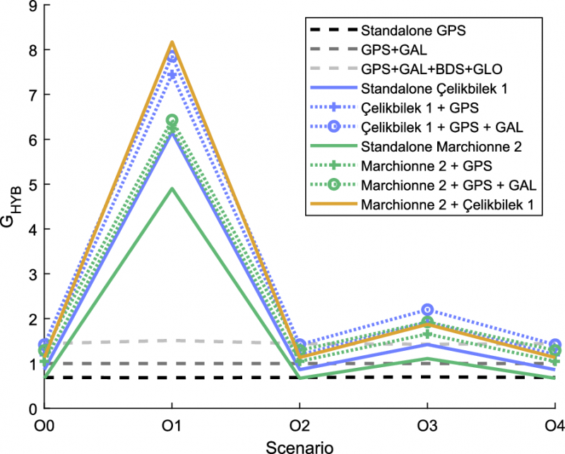
Using semi-analytical modeling and 192,000 Monte Carlo simulations, the team evaluated 400 users across European regions in five outdoor scenarios. Key variables included carrier bands (1.5/5/10 GHz), effective isotropic radiated power (EIRP) levels and constellation geometry design.
The team simulated multiple standalone and hybrid constellation architectures, analysing carrier-to-noise ratio (C/N0), geometric dilution of precision (GDOP), position dilution of precision (PDOP) and lower bound 3D accuracy.
Results indicate that an EIRP of 50 dBm is sufficient for high-quality outdoor positioning when operating in L- and C-bands. While 10 GHz platforms require higher power to compensate for path loss, hybrid LEO + GNSS modes show markedly improved stability and reliability.
Multi-shell constellations such as Çelikbilek-1 and Marchionne-2 delivered a favorable balance between satellite count and global geometry, outperforming single-shell layouts. In harsh urban canyon conditions, GNSS accuracy degraded up to seven-fold, whereas LEO-PNT maintained stable ranging performance with limited loss.
Interference resistance also improved. Stronger LEO signal power means jammers require far greater intensity to cause equal degradation. Hybrid designs provided the most significant gains. Combinations such as Çelikbilek-1 + GPS/Galileo, or CentiSpace + BeiDou, yielded better PDOP distributions, faster fix availability and broader user coverage.
The authors conclude that LEO systems are not aimed at replacing GNSS, but rather to enhance availability and resilience under signal-challenged environments.
“Our results show that moderate-power LEO constellations can substantially strengthen outdoor positioning without requiring expensive satellite hardware,” the authors noted. “Geometry plays a major role — carefully designed multi-shell constellations achieve strong accuracy even with fewer satellites. As LEO-PNT develops, hybrid integration with GNSS offers the most cost-effective path toward secure, robust PNT solutions. This work provides guidance for future system designers evaluating frequency, transmission power and constellation configuration trade-offs.”
The findings suggest a realistic rollout pathway for resilient satellite navigation. LEO-enhanced PNT could benefit autonomous vehicles, UAV routing, emergency response, precision farming and critical infrastructure monitoring — especially where GNSS falters in interference-dense or high-rise environments.
Lower-power LEO transmission also reduces deployment cost, opening access for commercial operators.
Future work may assess indoor positioning potential, bandwidth expansion, and real-orbit testing to refine simulation assumptions. As global demand for secure PNT grows, the integration of LEO and GNSS could become a cornerstone for next-generation navigation technology.
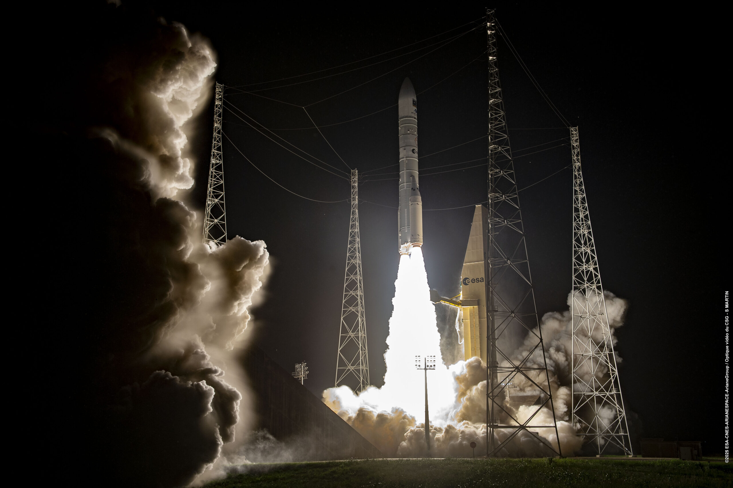
Europe has given fresh momentum to its Galileo navigation system following the successful Dec. 17 launch of two new satellites aboard an Ariane 6 rocket. The launch, the 14th of the program (L14), is one of the final three planned launches of first-generation (G1G) satellites. The two new satellites will strengthen the global positioning, navigation and timing services provided by the system.
The launch comes at a critical moment for the constellation, which needs to replace its oldest satellites, stated GMV, lead developer and operator of the Galileo ground control segment.
More than 4 billion users worldwide routinely rely on Galileo. This launch milestone ensures Europe’s ability to operate its own radionavigation system, which is essential for intelligent transportation, logistics, precision agriculture, defense, public safety, communications network operations, and energy generation and transmission.
From centers in Oberpfaffenhofen, Germany, and Fucino, Italy, GMV manages post-separation operations from the launch vehicle and ensures the correct insertion of the new satellites into the constellation. GMV also operates 24/7 to monitor the health and position of each satellite, plan and execute orbital maneuvers, ensure signal integrity, and manage critical system operations.
Coming soon: Second-Gen Galileo
The L15 and L16 missions will complete the first generation of the system before transitioning to the second-generation Galileo satellites (G2G) under development. These will introduce advanced capabilities, greater accuracy, and enhanced resilience against interference and cyber threats, further strengthening Galileo’s role as a strategic infrastructure for Europe.
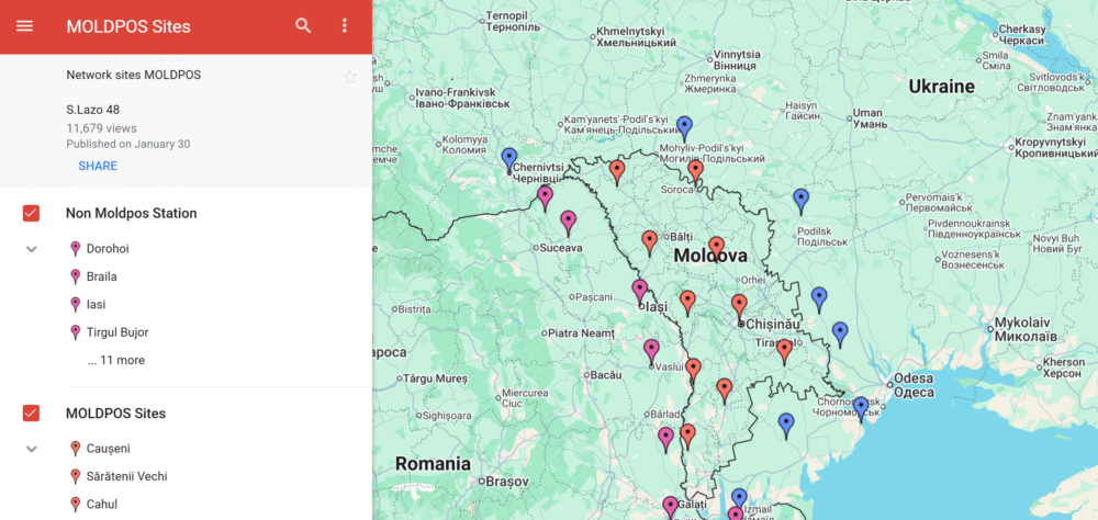
The MOLDPOS National Positioning System in Moldova has been integrated into the European Position Determination System (EUPOS), a pan-European GNSS augmentation service.
The MOLDPOS navigational system uses both GPS and GLONASS, and now Galileo has been added, according to Anatol Ghilas, director of the Agency of Land Relations and Cadastre (ALRC) of Moldova. Ghilas said the question of integration with the European system of Galileo was often discussed, and is a step forward in promoting the positioning technology.
Creation of MOLDPOS was gradual. First, sites for placement of MOLDPOS stations were selected, then the stations were installed. Once installations were in place, the system was tested and launched. Now it is integrated into EUPOS.
Moldova had been a member of the European Position Determination System since 2008.
According to Norwegian Ambassador to Moldova Øystein Hovdkinn, Moldova and Norway are situated in opposite parts of Europe, but it did not impede establishing friendly relations. Norway provided financial aid to build MOLDPOS.
Hovdkinn said that the Government of Norway supports the program of reforms in Moldova. The project’s goal is to promote Moldova’s development as a modern country and to promote its integration in Europe.
According to Gheorghe Duca, president of the Moldovan Academy of Sciences, implementation of MOLDPOS will have a positive influence upon the country’s social, economic and scientific sectors.
“A digital map is necessary for preventing floods, for rehabilitating roads, in agriculture and in science,” Duca said, adding that Moldova is the first country on the border with the European Union that will have digital maps, expected to be available in 10 months.
Adtran‘s Oscilloquartz synchronization platforms now support Galileo’s Open Service Navigation Message Authentication (OSNMA). OSNMA is a GNSS authentication service designed for civilian use.
By verifying that timing data originates from genuine Galileo satellites, OSNMA ensures authenticity and integrity at the point of reception. The new feature, available via firmware update for supported multi-band GNSS receivers, adds an extra layer of protection against spoofing and manipulation, empowering existing deployments to strengthen security without hardware changes or service disruption.
OSNMA support from Adtran brings a new level of GNSS security to critical infrastructure. Available for multi-band GNSS receivers in the OSA 5412, OSA 5422, OSA 5430 and OSA 5440 product lines, the feature integrates with Galileo’s Open Service, using digital signatures and TESLA chain keys to authenticate navigation data. This ensures that timing and positioning information is verified as authentic and protected against spoofing or manipulation.
Adtran’s Oscilloquartz Syncjack probing adds a second layer of defense, detecting record-and-replay attacks – also known as meaconing – by comparing GNSS signals against trusted PTP sources. This dual-layer approach helps identify subtle timing manipulations and delay attacks that traditional receivers may miss.
“From 5G and smart power grids to financial networks and data centers, bringing authentication to GNSS is a game changer for critical infrastructure,” said Gil Biran, GM of Oscilloquartz, Adtran. “By enabling our customers to defend against sophisticated threats, including meaconing, we’re helping them achieve greater timing integrity for their networks. Existing customers can access this new GNSS security feature with a simple firmware update, helping them stay protected as threats continue to evolve.”
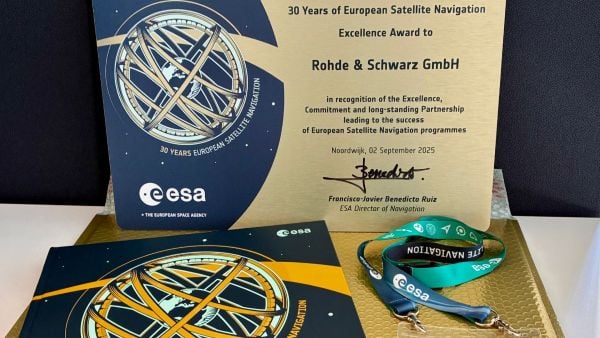
The European Space Agency (ESA) marked 30 years of European satellite navigation with a celebration Sep. 2 at its research and technology center. The event honored key contributors who have shaped the journey of systems like Galileo and EGNOS, which have positioned Europe as a global leader in satellite navigation.
Among the honorees was Rohde & Schwarz, recognized for the excellence, commitment and long-standing partnership leading to the success of European satellite navigation programs over the past three decades.
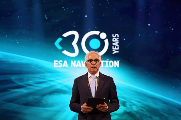
Javier Benedicto kicks off the celebration of 30 years of satellite navigation. (Photo: ESA)
The event brought together institutional and industrial partners, ESA Member State representatives, and leading figures in satellite navigation. The celebration revisited pivotal milestones in Europe’s satellite navigation history and looked ahead to future innovations.
A highlight of the evening was the award ceremony led by ESA Director of Navigation Javier Benedicto, who, alongside past directors, presented accolades to organizations and partners instrumental in this success story.
Rohde & Schwarz’s recognition underscores their role in advancing European satellite navigation technology. Their contributions have been vital in the development and operational success of Galileo and EGNOS, systems that have revolutionized positioning, navigation, and timing services across Europe and beyond.
The event not only celebrated past achievements but also set the stage for the future of European satellite navigation, with discussions around upcoming initiatives and advancements. For Rohde & Schwarz and other honourees, the evening served as both a celebration of past achievements and a call to continue building a connected, resilient, and sustainable future in space.
“Thirty years of satellite navigation is a testament to shared vision, determination to push technology boundaries, and intense, long-term collaboration,” said Rob Short, director of Business Development at Rohde & Schwarz. “We are honoured to have contributed to this remarkable achievement. Congratulations to everyone who made this milestone possible.”
In its pursuit of strengthening European resilience in navigation, the European Space Agency (ESA) took part in Jammertest. Jammertest 2025 brought together 360 participants from 120 organisations across more than 20 countries, spanning academia, industry and governmental institutions.
Incidents of deliberate GNSS interference are on the rise, wih attacks happening daily worldwide. Disruptions threaten safe operations of energy grids, banking infrastructure, emergency transportation and civil aviation, with an outage potentially costing billions of euros daily for Europe.
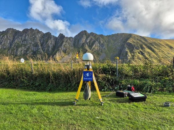
Bleik on the island of Andøya offered a suitable setting for Jammerfest. (Image: ESA)
Jammertest. In a complex coordination exercise among seven Norwegian public authorities and facilitator Testnor, Jammertest organisers broadcast real satellite navigation interference for participants to observe how their equipment (on vehicles, drones, aircrafts, helicopters and vessels responds.
At nearly 70 degrees North and 300 km inside the Arctic Circle, the small village of Bleik on the island of Andøya offers the ideal setting for Jammertest. To the east, towering mountains act as natural barriers that contain disruptive signals, minimising their impact on civil society. To the west, its open coastline allows signals to be transmitted over the sea, supporting maritime participants in addition to air and land users.
The event’s test catalogue is extensive. Organisers simulate everything from simple handheld jamming to complex multi-source attacks launched from several locations simultaneously, including from mountaintops. “The goal is that every receiver is knocked out at some point during the campaign,” explains Tomas Levin, senior principal engineer at Norwegian Public Roads Administration and head of Jammertest.
“At Jammertest, the full GNSS chain sits along a table, from chip manufacturers to those developing the algorithms that run on them, to the companies building products around those chips and the ones integrating these products into larger systems,” Levin said.
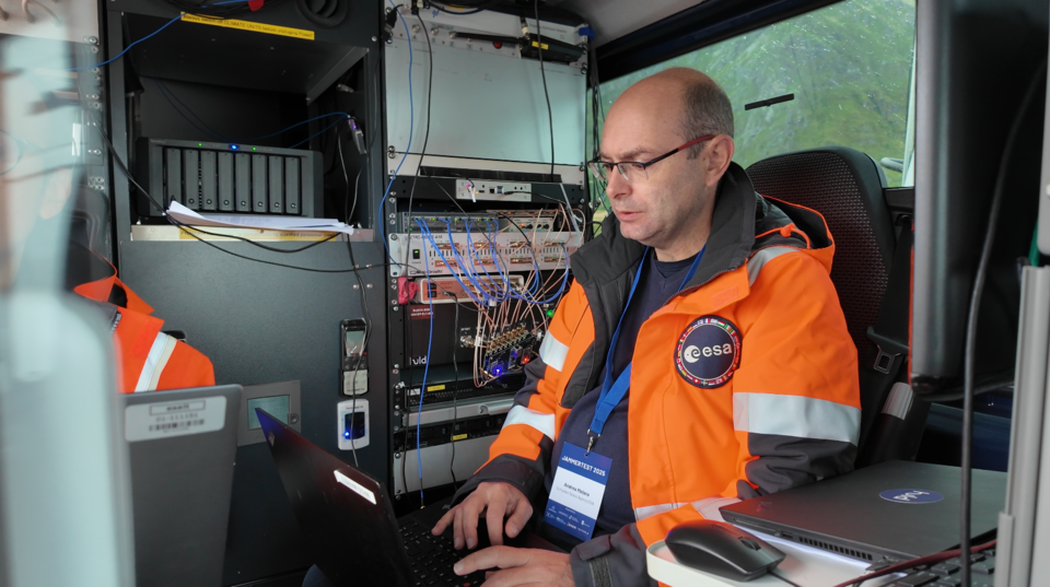
ESA’s navigation and telecommunications testbed vehicles are custom-built mobile test platforms operated by ESA’s Navigation Laboratory to support test campaigns for navigation and telecommunications services, most notably Europe’s Galileo constellation. (Photo: ESA)
ESA engineers arrived with several missions. As in previous years, the team tested the robustness of EGNOS and Galileo signals when picked by a range of antennas, from simple mass-market ones found in smartphones to military-grade antennas, both stationary and mounted on a moving van.
A key objective was to test the performance of novel receiver technologies developed under various ESA programs, comparing them to current technologies. The team also tested equipment provided by industrial partners under ESA’s Third-Party services.
More than 100 TB of data were recorded and will support internal research. Moreover, these data can now be replayed at the ESA Navigation Laboratory, allowing industry to analyse how new equipment responds to real-world interference scenarios. (If you are interested in using ESA’s NavLab testing and consultancy services, fill out the contact form on the Consultancy and Testing page).
Finally, ESA also oversaw tests of new EGNOS ground receivers being developed by European industry under Horizon2020 and Horizon Europe programmes. These receivers aim to improve the system’s robustness in its next generation.
A multi-beam satellite navigation antenna test. (Photo: ESA)
Several projects tested at Jammertest by other participants were funded through NAVISP, highlighting the agency’s role in fostering innovation across the GNSS ecosystem.
“Jammertest is a unique opportunity,” concludes Derambure. “Here we have the edge of technology, the edge of testing scenarios. There is nowhere else where we can test this material in real conditions. I believe Jammertest will become a mandatory step for any new satellite navigation receiver technology.”
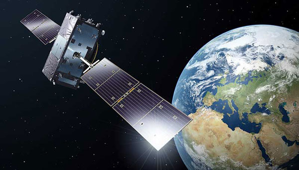
Developed by the European Union, Galileo is an independent, global, satellite-based navigation system that provides a range of services. Among its most significant advancements is the Galileo High Accuracy Service (HAS), which aims to offer free, high-precision positioning to users worldwide. This article explores Galileo HAS, covering its history, architecture, implementation phases, performance, limitations, and future prospects.
What is the Galileo High Accuracy Service?
Galileo HASis a precision augmentation service leveraging precise point positioning (PPP) to provide corrections to GNSS signals, aiming at a positioning accuracy of less than 20 cm horizontally and 40 cm vertically. Unlike the traditional real-time kinematic (RTK) method, which depends on local reference stations, HASdelivers corrections globally via Galileo satellites using the E6-B signal, as well as over the Internet. The service provides corrections for measurements on multiple frequencies across both Galileo and GPS constellations, enhancing real-time positioning performance.
The concept of a high-accuracy service for Galileo was driven by growing demand for decimeter-level accuracy in applications such as precision agriculture and autonomous vehicles. Initially envisioned as a paid service under the Galileo Commercial Service, feasibility studies in 2014 confirmed its potential. In 2018, the European Commission decided to offer HASfree of charge.
In the Galileo HASspecifications, two Service Levels are defined. Service Level 1 with global availability and the enhanced Service Level 2 for the European Coverage Area. The Galileo HASroadmap consists of three phases: Phase 0 (testing and experimentation), Phase 1 (Initial Service), and Phase 2 (Full Service). After extensive internal testing, Phase 1 was officially launched in January 2023, marking a significant milestone in Galileo’s evolution as a leading GNSS provider. Phase 2 is currently in development and expected to launch in the near future.
Technical Components
Galileo HASis designed with several key components that enable its high-precision capabilities. One of the most critical aspects involves orbit and clock corrections. These corrections compensate for inaccuracies in satellite orbital positions and clock errors, which are major sources of positioning errors in standard GNSS. Another essential element of HAS is the provision of signal bias corrections to enable precise carrier phase ambiguity resolution, which in turn greatly improves positioning accuracy. In the current Initial Service (Phase 1), Service Level 1provides only code bias corrections, along with orbit and clock corrections. In Phase 2, Service Level 1 will be upgraded to include both code and phase bias corrections, while Service Level 2will further add atmospheric (ionospheric and tropospheric) corrections for the European Coverage Area.
Capable GNSS receivers decode the high-accuracy corrections broadcast on the E6-B channel for Galileo (E1, E5a, E5b, E5, AltBOC, E6) and GPS (L1, L2, L5) signals and apply them via algorithms to enhance positioning solutions. This refines raw measurements to reduce errors, providing decimeter-level accuracy for use in fields rangiranging from ecological surveys to city infrastructure management and routine mapping tasks.
In addition to satellite broadcasts, the corrections are also made available over the Internet via the NTRIP protocol, providing an alternative access method for users with network connectivity. Notably, receiving HAS corrections via NTRIP eliminates the need for a receiver with E6-B capability, but the receiver still needs to implement the PPP algorithm to process the corrections.
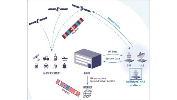
Architecture
The Galileo HASrelies on the robust infrastructure already established within the Galileo system. At the foundation of this network are the Galileo Sensor Stations (GSS), a global network of 15 monitoring stations (according to the latest updates). These stations play a vital role by continuously collecting GNSS measurements, which serve as the raw data needed to generate precise corrections. The collected data are then processed by the High Accuracy Data Generator (HADG). This system analyzes the GSSinput and produces high-precision corrections for both Galileo and GPS signals. Once the corrections are prepared, they are transferred to Uplink Stations (ULS), which transmit the correction data to the Galileo satellites for distribution via Signal-in-Space, or to an NTRIP caster for distribution over the Internet. In the case of Signal-in-Space distribution, the Galileo satellites themselves serve as the delivery mechanism to users worldwide, broadcasting the corrections globally via the E6-B signal.
The HAS is being rolled out in three phases, ensuring progressive development and refinement:
Phase 0 (2020–2022): Internal Testing
Focused on validating the feasibility of broadcasting HAS corrections via the E6-B signal.
Tests involved internal and external stakeholders, with feedback used to refine the service.
Phase 1 (January 2023–Present): Initial Service
Declared operational on January 24, 2023, Phase 1 provides Service Level 1 with global coverage, though with reduced performance compared with the enhanced Service Level 1 expected in Full Service (Phase 2).
Current corrections include orbits, clocks, and code biases.
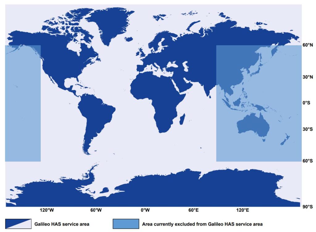
The service area excludes certain regions (e.g., parts of the Pacific and Australia) because of infrastructure limitations.
Convergence time is specified as <300 seconds (Service Level 1) or <100 second (Service Level 2), with horizontal accuracy <20 cm and vertical accuracy <40 cm under optimal conditions. Currently, accuracy <20 cm may be achieved with a convergence time up to 60 minutes, owing to the lack of phase bias and atmospheric corrections.
Phase 2 (Future): Full Operational Capability
Will provide full Service Level 1 performance globally with horizontal accuracy <20 cm and vertical accuracy <40 cm, adding phase bias corrections for faster convergence <300 seconds.
Will introduce Service Level 2 for regional coverage in Europe with horizontal accuracy <20 cm and vertical accuracy <40 cm, adding phase bias and atmospheric corrections for faster convergence (<100 seconds).
Will include data authentication and enhanced infrastructure for improved reliability and coverage.
Challenges and Limitations
The current capabilities of Galileo HASare constrained by several limitations, which are expected to diminish as the system evolves. Global coverage is not yet fully established, with parts of the Pacific region and Australia remaining outside the service area. While users can receive HAScorrections anywhere in the world, the official performance specifications apply only within the service boundaries. However, even within the service area, achieving the specified accuracy presently requires long convergence times, limiting applicability in scenarios that demand rapid solutions. Convergence time is expected to decrease significantly in Phase 2, when phase bias and atmospheric corrections are introduced.
As of 2025, relatively few commercial receivers support HAScorrections via E6-B, with availability concentrated in professional and industrial receivers. The lack of integration into mass-market devices limits broader adoption, reflecting both the technology’s ongoing development and the additional hardware complexity required to receive HAScorrections.
Finally, while decimeter-level corrections are sufficient for a wide range of applications, many professional domains, such as surveying, demand cm-level accuracy. Even at Full Service, HASwill not provide this level of precision, meaning that certain fields will continue to rely on RTK. However, considering that most RTK vendors require a paid subscription or charge per hour, HAScan still provide great value to surveyors and other professionals through its use in preliminary work or applications where cm-level accuracy is not critical, offering decent accuracy free of charge.
The Galileo constellation was recently reinforced with satellites 31 and 32, which became operational in January 2025, while the ground segment underwent major upgrades in 2024. Despite these improvements, Phase 1 (Initial Service)remains the only operational HAS capability. As of September 2025, Phase 2remains in active development. In January 2025, it was announced that the European Union Agency for the Space Programme (EUSPA) awarded GMV a 45-month, €12 million contract to develop an enhanced HADGthat will support enhanced Service Level 1 globally and Service Level 2 for Europe. The contract’s duration provides an indication of the anticipated timeline for completion.
An inquiry regarding the timeline for Galileo HASService Level 2 (Phase 2) was submitted to the European GNSS Service Centre (GSC) Helpdesk. Their reply stated that the schedule is not available at this time and will be announced through GSC channels once released.
Wider adoption is anticipated as more GNSS receivers capable of receiving and decoding the E6-B signal to process HAScorrections become available, enabling sectors such as autonomous transportation, fleet management, and smart agriculture to capitalize on improved performance. Adoption is also expected to accelerate when Galileo HAS reaches Full Operational Capability with the launch of Phase 2, which will reduce convergence times and broaden the system’s applicability.
Ultimately, Galileo HASis positioned to become a cornerstone of high-accuracy GNSS, democratizing access to professional-grade precision.
The European Space Agency (ESA) has confirmed plans to launch the first two satellites in its low-Earth orbit (LEO) positioning navigation and timing (PNT) constellation in the second half of December 2025. The launch will use a Rocket Lab Electron Vehicle, marking Europe’s first venture into LEO-based satellite navigation.
The LEO-PNT in-orbit demonstrator mission, called Celeste, aims to test satellite navigation capabilities in LEO and evaluate its integration with existing medium-Earth orbit (MEO) systems.
Celeste features a constellation of ten satellites that will fly close to Earth to test innovative signals across various frequency bands. The first two Celeste satellites, built in parallel by GMV and Thales Alenia Space, are set to launch in the coming months.
The dedicated Electron rocket launch will place both satellites in orbit at 510 km altitude. The launch window extends for three months beginning in mid-December 2025, with operations conducted from Rocket Lab’s New Zealand facility.
ESA Director of Navigation, Javier Benedicto, said, “We are thrilled to see the LEO-PNT demonstration advancing so quickly, with less than two years between mission kick-off and launch. This launch ensures the first European LEO-PNT satellites are in space before spring 2026, crucial for bringing the frequencies into use in compliance with the International Telecommunications Union.”
Galileo’s “Daughter Mission”
The name Celeste pays homage to Maria Celeste, Galileo Galilei’s daughter, as the two shared a strong emotional and intellectual bond, with the daughter honoring her father’s astronomical interest. This symbolic connection links the pioneering work of the father of modern astronomy to contemporary navigation systems, with Celeste serving as a bridge between Galileo’s groundbreaking discoveries and today’s satellite-based positioning technology.
The demonstrator satellites for Galileo, launched in 2005 and 2008, were called GIOVE, after the Italian word for Jupiter. This name also paid tribute to Galileo’s achievements in discovering the planet’s four largest Moons which were used to determine longitude from anywhere on Earth.
System Advantages
The initial Pathfinder A satellites are CubeSats measuring 12U and 16U formats, comparable to suitcase size and weighing approximately 20 kg to 30 kg. These satellites will broadcast in L-band and S-band frequencies and operate for at least six months following orbital commissioning.
The larger, more complex Pathfinder B satellites will follow, incorporating additional payloads to test innovative signals across multiple frequency bands and demonstrate expanded services.
LEO-PNT satellites will supplement existing GNSS constellations by providing enhanced coverage in challenging environments. The system aims to improve navigation services in deep urban areas, under heavy foliage, in polar regions and potentially indoor locations where current MEO satellites face limitations.
The complete demonstrator constellation, expected to be operational by 2027, will assess how LEO navigation systems can integrate with existing GNSS infrastructure. The mission will also test interoperability with 5G and 6G communication standards.
Preparing for Launch
Satellite integration and testing of Pathfinder A hardware and software continues ahead of the December launch. ESA and industrial teams plan to complete testing during summer 2025, with qualification and acceptance reviews scheduled for autumn.
“Pathfinder A satellites have already paid off, even before launch,” said Roberto Prieto-Cerdeira, ESA’S LEO-PNT project manager. “The experience gathered during their development is helping to identify critical technologies, system design trade-offs, design choices and optimised approaches and processes, paving the way for future phases of LEO-PNT. Having them in orbit and validating their signals and algorithms is a major additional achievement.”
Future Plans
Following the demonstrator mission, ESA plans to propose an in-orbit preparatory phase at the agency’s November Ministerial Council meeting. This phase would focus on technology development and industrialization, potentially leading to an operational system integrated with EU GNSS infrastructure.
The Celeste demonstrator is part of FutureNAV, an ESA Navigation program designed to maintain Europe’s position at the forefront of satellite navigation technology.
The mission receives backing from 15 ESA member states: Austria, Belgium, Finland, France, Germany, Hungary, Italy, Norway, Poland, Portugal, Romania, Spain, Sweden, Switzerland and the United Kingdom. More than 50 entities from 14 countries participate in the two development consortia awarded contracts in 2024.
The European Union Agency for the Space Programme (EUSPA) has officially declared its Galileo Open Service Navigation Message Authentication (OSNMA) initial service operational. OSNMA introduces a data authentication mechanism for Galileo Open Service users and is available free of charge to Galileo users worldwide.
Spoofing is the transmission of counterfeit satellite signals that deceive GNSS receivers, causing false, unreliable positioning that can disrupt critical sectors including transportation, finance, telecommunications, energy, manufacturing, healthcare, emergency services and law enforcement. In safety-critical domains such as aviation and maritime, spoofing risks can lead to serious safety hazards.
OSNMA addresses these threats by embedding a cryptographic digital signature within the Galileo navigation message (I/NAV) broadcast on the E1-B signal. This digital signature allows receivers equipped with OSNMA to verify that the signal truly originates from Galileo and has not been tampered with or spoofed.
OSNMA is integrated into the Galileo Open Service signal, which is already used by most GNSS devices. This means no change to existing Galileo signal structure or navigation performance, preserving full backward compatibility. Non-OSNMA receivers continue to function normally, while OSNMA-capable receivers decode and authenticate the digital signature.
The European GNSS Service Centre (GSC), located at the National Institute for Aerospace Technology (INTA) in Torrejón de Ardoz, Spain, manages the generation and transmission of authentication messages to Galileo’s ground segment. The OSNMA service was developed in collaboration with industrial partners, including GMV and INDRA, who also contributed to Galileo’s High Accuracy Service (HAS), operational since January 2023.
The European Union Agency for the Space Programme (EUSPA) has awarded GMV a framework contract to advance the Galileo Reference Centre (GRC), a key facility for monitoring and evaluating the performance of the Galileo satellite navigation system. Located in Noordwijk, the Netherlands, the GRC independently assesses Galileo’s operations, signal quality, and user-level service performance and compares its performance with that of other GNSS.
The upcoming GRC V2 version will introduce real-time monitoring capabilities, enhancing EUSPA’s ability to oversee GNSS services. This evolution will support additional Galileo services, including:
Signal Authentication Service (SAS): Strengthening trust in Galileo signals.
Time Dissemination Service: Enabling precise synchronization for critical infrastructure.
Search and Rescue (SAR): Improving emergency response operations.
Emergency Warning Satellite Service (EWSS): Facilitating public alerts for natural disasters and emergencies.
Key operational improvements in GRC V2 include:
Enhanced monitoring using data from multiple institutions.
Real-time processing for faster user notifications.
Seamless system upgrades without disrupting operations.
Advanced cybersecurity measures integrated into a platform-as-a-service model.
The upgraded GRC is expected to be operational by 2026 without impacting ongoing functions.