Here’s a panorama in broad strokes across the range of GNSSs, garnered from top system spokespersons at the Munich Satellite Navigation Summit. It’s been several years since breaking news was aired at this annual late winter/early spring event, but it’s always good for a wide-ranging update, recalibrating levels, so to speak.
GPS. With 31 operational satellites (24 is baseline) and an estimated 3 billion receivers in use worldwide, what more needs to be said about the gold standard? Its best week ever for accuracy logged a signal-in-space performance average of 45.3 centimeter. The next-generation ground control system OCX “survived quite a struggle” and has emerged from Nunn-McCurdy breach, back on track and seemingly ready for future action. Or at least for future pre-certification tests. SV1 of the GPS III generation has completed all tests and is in storage, awaiting the first GPS III launch in spring 2018. SV02 and 03 are in assembly and integration, SV04 thru 08 are in box-level assembly, and 09 and 10 are on contract. Technical challenges with payload have been resolved.
(Click to enlarge.) Galileo satellite top-level block diagram. OHB Systems AG as prime contractor and Surrey Satellite Technology (SSTL) have teamed for production of the navigation satellites. OHB is responsible for the concept, the satellite platforms and the satellite-level inegration and test. SSTL supplies the satellite payloads and supports OHB on system level. OHB also supports the customers during launch preparation and in-orbit testing. (Image courtesy OHB)
Galileo. With 18 on-orbit satellites (15 operational), the European GNSS can be termed a coming thing. Performance statistics are based on only 11 of these satellites however; the four most recently launched in November 2016 are not yet included. Nevertheless, the system is logging 80-centimeter ranging accuracy. Eight more await launch: four in 2017, and four in 2018. The constellation is broadcasting the Open Service, the Public Regulated Service, and the Search and Rescue (SAR) signal. The SAR service will officially launch in early April — on April 6, because 406 MHz is the Emergency Position Indicating Radio Beacon frequency. Galileo has improved the historic SAR location performance from 3 hours to 10 minutes. The Commercial Service is still in preparation, and will be available in 2020. Spoofing is seen as a very real threat to GNSS overall by the Galileo authorities, as exemplified by the recent bloom of amateur spoofers encouraged by Pokemon go.
GLONASS. The Russian system will undertake three or four launches this year; one of them will be a triple-satellite launch. There have been several disruptions to efforts to decrease the offset between GLONASS system time and Universal Coordinated Time but the initiative perseveres. English versions of four system interface control documents (ICDs), to include the new CDMA signal, are promised for Q2 2017; Chinese versions are coming, too. Russian-language ICDs are available at glonass.aic.ru.
BeiDou. With the addition of three new satellites in the past year, China’s system is enjoying improved system performance. Hydrogen clocks are succeeding rubidium clocks, bring an order-of-magnitude improvement in timing accuracy. A BeiDou white paper was published last June, and a revised ICD appeared in November.
In the massive Chinese mass market, 30 percent of smartphones sold in China now have BeiDou capability; that’s out of a 700–800 million total. Huawei multi-function chip LX1101 is a key driver behind this. Unistrong has released a phone with RTCM input for professional use, blurring the line between mass and professional markets.
Six to eight satellites will be launched this year, and 10 to 12 in 2018. BeiDou is in a “very ambitious and aggressive race with time to complete the global system.”
ICG. The United Nations’ International Committee on Global Navigation Satellite Systems will meet in Japan in December of this year, in China next year, and in India in 2019. This can be interpreted as vigorous international interest and “a desire to advance and promote their respective systems’ visibility” worldwide. All pertinent documents can be found at unoosa.org.
EGNOS. The European Geostationary Navigation Overlay Service has two operational geosynchronous Earth-orbit satellites (GEOs) in operation, plus one in test and one in deployment, ready to swap in. It is extending its Ranging and Integrity Monitoring Stations (RIMS) to several new countries, notably Israel and the Ukraine. EGNOS.v3 is coming and will introduce dual-frequency (L1 and L5) service, and also Galileo with GPS, for multi-constellation corrections. The new system’s qualification is planned for 2022.
QZSS. This year, Japan’s Quasi-Zenith Satellite System will launch the second and third of the figure-eight inclined geosynchronous orbit (IGSO) satellites of the Michibiki type, to become operational in 2018. A GEO bird will also be launched. A seven-satellite system is the ultimate goal.
Among other announcements of note made during the course of the Summit, although not by the GNSS operators’ spokespersons:
(Click to enlarge.) Key features of the Galileo satellites.
• OHB, the Galileo satellite manufacturer, said its customer has decided to refurbish the clocks on eight satellites in preparation. “Satellite navigation is nothing but comparison of very precise clocks.”
• Airbus announced a new concept for train positioning integrity: “virtual valises” to correct train position that will replace or augment current trackside valises that are very expensive to build and maintain.
• Munich Aerospace (munich-aerospace.de), a public-private non-profit venture between DLR, the German space agency, Bauhaus Luftfahrt and two technical universities, will mount a Ph.D-level education and research program for 70 individuals, with candidates from 27 nations. This will be located in “the Bavarian Silicon Valley.” It will also undertake a global effort with several other organizations.
• One of the above technical universities, the Federal Armed Forces University in Munich, announced that it is investigating Lidar for potential use in an asteroid mining project for future space exploration. It also has underway initiatives concerning Lidar + GNSS and inertial + GNSS for autonomous vehicles.
All across Europe, the number of smart cities is multiplying. To tackle their growing needs and to guarantee efficient city planning and maintenance, many cities are engaged in massive investments in such key areas as street lighting, road maintenance, traffic and waste management.
In parallel, public transportation is continuously evolving in terms of coverage, comfort and technology.
Within this context, the exploitation of Galileo and its integration with other sensors is key to developing concrete solutions for current and future smart-city planning. Along these lines, the Horizon 2020-funded GHOST (Galileo Enhancement as Booster of the Smart Cities) project is designing, developing and validating an intelligent system for vehicles that equips existing public transport fleets with a Galileo-enabled camera and connects these vehicles to a web portal.
The GHOST system equips existing public transport fleets with a Galileo-enabled camera and connects these vehicles to a web portal. (Photo: GSA)
The system automatically takes pictures of predefined points of interest (POI) based on the accurate position of the vehicle — provided by Galileo. All images are sent to a processing server capable of detecting such anomalies as potholes or a burnt-out street light. The system then uses the web portal to report these findings to the relevant authorities.
“At this point, GHOST is designed primarily for reporting street lighting anomalies and road deteriorations, monitoring public garbage collection and detecting double parking infractions or disabled parking spots occupied by unauthorized vehicles,” said Project Coordinator Claudia Maltoni. “In addition to these basic functions, we have also identified more advanced services, such as spotting bus-lane and congestion-charging-area violations, which will be implemented at a later date.”
A user-focused system
The GHOST system’s key differentiator is its use of Galileo positioning, which gives it the capability to take autonomous snapshots with an error range of 1 to 10 meters (depending on the size of the POI). In densely populated urban environments, such a level of service is only possible with the combined use of Galileo, inertial sensors and Kalman filters.
The GHOST system’s key services:
reporting street lighting anomalies and road deteriorations
monitoring public garbage collection levels
detecting double parking infractions or disabled parking spaces occupied by unauthorized vehicles
monitoring timely collection of garbage.
Another unique feature is a free smartphone application that citizens can use to collect geo-localized snapshots. “Whenever an individual user sees an anomaly within a city’s infrastructure, all they have to do is snap a picture with their smartphone,” explained Maltoni. “This level of engagement not only enhances the overall system, but also empowers individual users to play a key role in urban upkeep.”
Improving urban efficiency
By taking advantage of the many vehicle movements happening in cities every day, GHOST proposes a competitive way to improve the efficiency of monitoring a city’s operations and infrastructure. Once finalized, the system will enable faster detection of double parking or road deterioration and help reduce traffic, accidents and pollution.
“Thanks to our field tests and favourable lab results, we are already setting up the next phase of the project, with the aim of taking the system’s technology to the next level,” concluded Maltoni. “This includes providing real-time, onboard image processing so that the system can handle such dynamic scenarios as bus-lane infractions and congestion-charging enforcement.”
The project is working to bring GHOST technology to market. Coordinators are busy making key contacts with interested public administrations, garbage collection companies and traffic police departments. It is also working to ensure that the system complies with all European regulatory standards, such as those related to circulation or privacy.
The European Commission and the European GNSS Agency (GSA) confirm that the first generation of Galileo will already provide users with high accuracy and authentication services. Both the commission and GSA have adopted the Galileo Commercial Service Implementing Decision.
The Commercial Service will complement the Galileo Open Service by providing an additional navigation signal and added-value services in a different frequency band. Unlike the Open Service, the Commercial Service signal can be encrypted in order to control access to Galileo Commercial Services.
“The Commercial Service is unique in that its services are not provided by any other GNSS programme and thus represents a unique opportunity for Galileo to differentiate itself from other systems and offer users an added value to the standard positioning services already available,” says GSA Executive Director Carlo des Dorides.
With the Commercial Service, Galileo users will benefit from:
High Accuracy service based on the transmission of Precise Point Positioning information through its E6-B signal, delivering accuracy below one decimeter worldwide; and
Commercial Authentication service based on the E6 signal code encryption, allowing for increased robustness of professional applications.
Following the Commercial Service Implementing Decision, the user community will also be able to use the Open Service Navigation Message Authentication (OS NMA) for free. The OS NMA is capable of protecting users from spoofing attacks by digitally signing the Open Service message in the E1 band.
The High Accuracy and Commercial Authentication services will most likely be provided for a fee, and at least one signal component of the Galileo E6 signals will remain freely available, allowing user communities to benefit from signals in all Galileo bands.
To avoid disrupting existing professional markets, the Commercial Service will be most likely be operated by at least one yet-to-be-determined commercial service provider. All three services are compatible with the current signal definition and are based on existing infrastructure.
After a test period, the Galileo Commercial Service will become available when Galileo reaches Full Operational Capability, which is expected by 2020. It will complement the Galileo Open Service, Public Regulated Service and Search and Rescue service — all available now via the Galileo Initial Services.
Additional satellites will be successively added to the constellation, with the launch of the next four foreseen in 2017.
On Feb. 11, the European Union (EU) celebrated 112 Day in honor of the single European emergency phone number. The 112 system uses Advanced Mobile Location (AML) to receive location information from mobile phones.
Photo: 112 SOS
Every year, about 300,000 people who call the emergency services cannot describe their location because they may not know where they are, because they are too young to say or they are too injured to communicate. In these situations, knowing the exact location of the caller can help emergency services react quickly and save lives, according to the European Commission.
Europeans can dial 112 for free in any EU country if they need to contact emergency services, thanks to EU legislation introduced in 1991. Today’s mobile and smart devices are able to provide emergency services with accurate caller location via an SMS or data channel using GNSS or Wi-Fi capabilities.
An EU-financed project — HELP 112 — looked into how GNSS can improve caller location using the AML solution. It was tested in the United Kingdom, Lithuania, Italy and parts of Austria.
A new report shows significant improvement for caller location in several EU countries. Lithuania upgraded its network-based location solution to ensure significantly more accurate caller location. The United Kingdom and Estonia deployed the AML handset-based caller location solution that can locate a person to within 100 meters.
Currently, AML handset-based caller location for emergency services is available only on Android phones.
The system has already saved lives. On Jan. 10, an emergency call was received by the Klaipeda Public Safety Answering Point in Lithuania. The caller was an 8-year-old boy who reported he had found his father unconscious or dead, probably struck by electricity. He told the operator that he didn’t know his address or the telephone number of any of his relatives.
Although the boy unaware of his address, cell-ID location information received by the emergency services had a radius of 14 kilometers. Fortunately, around one minute after the call was received, the operator received the location via Android Emergency Location (Advanced Mobile Location), with a radius of 6 meters.
The police and ambulance services were dispatched, and emergency responders provided acute medical care to the man who had suffered an epileptic seizure.
In Austria, a woman riding a horse fell on her head and was unable to describe where she was. GNSS provided emergency services with her exact location within seconds, so she could be rescued.
Galileo increases accuracy
“Satellite navigation is crucial in determining the precise location of the 112 caller and saving lives,” says Commissioner Elżbieta Bieńkowska, responsible for internal market, industry, entrepreneurship and SMEs. “Galileo, Europe’s own satellite navigation system, will be able to locate the caller with much greater accuracy. The launch of Galileo’s initial services and first Galileo smartphones available on the market show how space data is making a difference in daily lives of EU citizens.”
In addition to funding research, the commission is also improving EU rules on 112. In September 2016, the commission proposed an update of EU telecom rules in the form of an Electronic Communication Code. The commission wants to enhance the relevant provisions of the Universal Service Directive to facilitate the use of handset-based caller location as complement to network-based location data.
According to the proposal, member states will be obliged to ensure that caller location, be it network based (provided by the mobile operator) or handset based (retrieved from a GNSS or Wi-Fi enabled phone), arrives in a timely manner to the public safety answering point that handles emergency calls.
Whichever technology is used, caller location will be free for citizens and the public safety answering points.
The European Space Agency (ESA) issued a press release addressing the Galileo clock failures reported Jan. 18. GPS World Innovation editor Richard Langley provided the following summary of the satellites and clocks involved, based on information we have received to date.
5 satellites affected: 3 IOVs, 2 FOCs
Total of 10 failures; 1 fixed; so 9 continuing failures
5 masers on IOV satellites
2 masers on FOC satellites but 1 of these fixed
3 rubidiums on FOC satellites
No satellite currently has fewer than 2 working clocks
The ESA press release provides additional details on the failures and actions being taken to address the problem.
Press Release from the European Space Agency
As first reported November 2016, anomalies have been noted in the atomic clocks serving Europe’s Galileo satellites.
Anomalies have occurred on five out of 18 Galileo satellites in orbit, although all satellites continue to operate well and the provision of Galileo Initial Services has not been affected.
Highly accurate timing is core to satellite navigation. Each Galileo carries four atomic clocks to ensure strong, quadruple redundancy of the timing subsystem: two Rubidium Atomic Frequency Standard (RAFS) clocks and two Passive Hydrogen Maser (PHM) clocks.
The current Galileo constellation consists of 18 satellites in orbit, adding up to a total of 36 RAFS clocks and 36 PHM clocks.
Rubidium atomic clock, or RAF.
RAFS clocks
In recent months, a total of three RAFS clocks unexpectedly failed on Galileo satellites — all on Full Operational Capability (FOC) satellites, the latest Galileo model. These failures all seem to have a consistent signature, linked to probable short circuits, and possibly a particular test procedure performed on the ground, with investigations continuing to identify a root cause.
No RAFS clock failures have occurred aboard the four Galileo In Orbit Validation (IOV) satellites, the original Galileo model. In addition the RAFS clock on ESA’s very first test navigation satellite, GIOVE-A launched in 2005, has been checked, and was reactivated successfully.
Continuing investigations on the ground have identified potential weaknesses in the RAFS clock design, but no root cause has yet been yet established.
PHM Clocks
Passive hydrogen maser atomic clock of the type flown on Galileo, accurate to one second in three million years. (Photo: ESA)
In the past two years, there have been five PHM clock failures on the IOV satellites and one PHM failure on the FOC satellites.
These failures are better understood, linked to two apparent causes. One is a low margin on a particular parameter that leads, on some units, to a failure. The second is related to the fact that when some healthy PHM clocks are turned off for long periods, they do not restart because of a change in clock characteristics in orbit. To date, two PHM clocks have failed owing to the first mechanism, and four to the second.
Corrective Actions
For the remaining 33 RAFS clocks in orbit, the risk of failure is believed to be lower owing to different testing procedures on the ground before launch. In addition, new operational measures have been put in place to further mitigate the risk. All these measures have no effect on Galileo’s overall performance.
While investigations by ESA and its industrial partners are continuing, there is consensus that some refurbishment is required on the remaining RAFS clocks still to be launched on the eight Galileo satellites being constructed or tested, and awaiting launch.
For the remaining 30 PHM clocks working in orbit, operational procedures are being studied to significantly reduce the risk of future failure. These measures are being validated, ahead of their planned introduction in a few weeks.
Looking Forward
Overall, three out of four IOV satellites have experienced clock anomalies, and two out of 14 FOC satellites.
As ESA Director General Jan Woerner commented during his Jan. 18 press briefing, no individual Galileo satellite has experienced more than two clock failures, so the robust quadruple redundancy designed into the system means all 18 members of the constellation remain operational. This includes one satellite that supports only the Open Service for mass-market applications, and two satellites in elliptical orbits that are nevertheless expected to be reintegrated into the full constellation for use from these orbits.
Similarly, Galileo’s Initial Services, which began on Dec. 16, have been unaffected by these anomalies.
The impact of RAFS and PHM clock refurbishment on Galileo’s launch schedule is under study, but ESA is confident that the clock issues will be resolved and remains committed to launch the next four Galileo FOC satellites before the end of this year.
Director General Press Briefing
January 18, 2017
Clock problems are discussed at about the 12-minute mark, and in the Q&A portion started at the 52-minute mark.
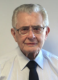
Vidal Ashkenazi, founder and CEO of Nottingham Scientific Ltd (NSL), has been awarded an OBE in the 2017 New Year’s Honours List for Services to Science.
An OBE is a Queen’s honor given to an individual for a major role in any activity such as business, charity or the public sector. OBE stands for Officer of the Most Excellent Order of the British Empire.
“I am absolutely delighted to have been awarded an OBE,” Ashkenazi said. “However, even more importantly, at long last this award recognizes the contribution of scientists and technologists to society in terms of satellite positioning, navigation and timing.
Vidal has been involved with the geodetic aspects of positioning by using satellites from the earliest days. In 1976 he was invited by the U.S. National Geodetic Survey (NGS) to assist with the development of geodetic coordinate systems, the framework that is still used today by satellite navigation (satnav) and mapping systems.
Ashkenazi was an academic at the University of Nottingham from 1965 to 1998, and the founding director of the Institute of Engineering Surveying and Space Geodesy, one of the leading space geodesy research institutes in the world. He supervised around 50 doctoral (Ph.D.) students, many of whom now occupy senior positions in universities and industry around the world.
In the late 1990s, Ashkenazi became aware that, although GPS was designed and developed as a military system, its main advantage to the U.S. was economic. This was the message he delivered when he was invited in 2003 to address the Industry, External Trade, Research and Energy (ITRE) Committee of the European Parliament in Brussels, and hence the need for the European Union to have its own satellite navigation system. Europe’s Galileo system entered into service in December 2016.
Following his academic career, Ashkenazi founded Nottingham Scientific Ltd (NSL) to commercialize the innovation and expertise developed and Nottingham and other UK universities.
Vidal Ashkenazi, who has doctorates in philosophy and physical science from Oxford University, is a member of a large number of professional organizations, and has received distinction awards from several of them, most notably the Royal Institute of Navigation.
He has published several hundred papers in professional journals, and acted as a consultant to a large number of government and commercial organizations in North and South America, Europe, the Middle East and Asia.
Vidal Ashkenazi is a recognized figure on the international scene of conferences and congresses, to which he is invited regularly either to deliver keynote presentations or to organize and chair round-table panel discussions.
He is also a long-standing member of the GPS World Editorial Advisory Board.
At a Dec. 15 ceremony in Brussels titled “Galileo Goes Live,” two high officials of the European Commission issued the Galileo Initial Services Declaration.
The declaration means that the Galileo satellites and ground infrastructure are now operationally ready. These signals will be highly accurate but not available all the time, since the constellation is not yet complete and users cannot always count on four satellites being visible at one time at all points on the Earth.
Galileo Goes Live! ceremony in Brussels: European Commission Vice-President Maroš Šefčovič, responsible for the Energy Union, and Commissioner Elżbieta Bieńkowska, responsible for Internal Market, Industry, Entrepreneurship and SMEs, count down to hit the “Go” button. Photo: Galileo
Simultaneously, the European GNSS Agency (GSA) awarded the Galileo Service Operator (GSOp) contract, with a value of up to 1.5 billion euros, to Spaceopal, a joint venture between Telespazio and the German Space Agency (DLR).
The Galileo constellation currently consists of 18 satellites in orbit. However, two of these are in an orbit not totally useful for positioning and navigation. Four more, launched in November, may or may not have completed their on-orbit testing (a series of notice advisory to Galileo users or NAGUs has appeared relating to the flag status of each satellite; see details at the end of this story) but have not yet been integrated to the operational constellation. This is expected to take place in spring 2017.
During the initial phase, the first Galileo signals will be used in combination with other satellite navigation systems, like GPS. In coming years, new satellites will be launched to enlarge the constellation, gradually improving Galileo availability worldwide. The constellation is expected to be complete by 2020 when Galileo will reach full operational capacity (FOC) of 30 satellites: 24 satellites plus six orbital spares, intended to prevent any interruption in service.
Paul Verhoef, the European Space Agency’s (ESA’s) director of the Galileo Programme and Navigation-related Activities, stated, “Today’s announcement marks the transition from a test system to one that is operational. Still, much work remains to be done. The entire constellation needs to be deployed, the ground infrastructure needs to be completed, and the overall system needs to be tested and verified.
“In addition, together with the commission we have started work on the second generation, and this is likely to be a long but rewarding adventure.”
Galileo Initial Services are managed by the GSA. The overall Galileo programme is run by the European Commission, which has handed over responsibility for the deployment of the system and technical support to operational tasks to the ESA.
Operator Contract. The GSOp contract runs for 10 years and covers operation and maintenance of the Galileo satellite system and its committed performance level: in particular, the operations and control of the system, the logistics and maintenance of the systems, and infrastructure as well as the user support services.
“With its emphasis on service performance, this contract will shape the future of Galileo. We look forward to building a strong partnership with Spaceopal as Galileo moves towards full operational capability under the responsibility of the GSA from January 2017,” said GSA Executive Director Carlo des Dorides.
Under GSA management, the contract awarded to Spaceopal specifically includes:
Secure operations of Galileo from two mission control centres (GCC), located in Germany and Italy, and the European GNSS Service Centre (GSC) for user support services in Spain;
Management of the Galileo Data Distribution Network (GDDN);
Integrated logistics support and maintenance for the entire space and ground infrastructure;
Monitoring of the system performance;
Support for the completion of the Galileo infrastructure and associated launches.
Spaceopal has served as the contractor for Galileo operations since 2010 under the Galileo Full Operational Capability (FOC) Operations Framework Contract.
Products and Services. The first Galileo smartphone by Spanish company BQ is now available on the market, and other manufacturers are expected to follow suit. Application developers can now test their ideas on the basis of a real signal.
With the declaration, Galileo will start to deliver, in conjunction with GPS, the following three types of services free of charge. Their availability will improve as more satellites are launched.
The Open Service is a free mass-market service for users with enabled chipsets in, for instance, smartphones and car navigation systems. Fully interoperable with GPS, combined coverage will deliver more accurate and reliable positioning for users.
Public Regulated Service is an encrypted, robust service for government-authorized users such as civil protection, fire brigades and the police.
Search and Rescue Service is Europe’s contribution to the long-running Cospas–Sarsat international emergency beacon location. The time between someone locating a distress beacon when lost at sea or in the wilderness will be reduced from up to three hours to just 10 minutes, with its location determined to within 5 kilometers, rather than the previous 10 kilometers.
Advisory Updates. USABINIT NAGUs were issued for 11 satellites: 0101, 0102, 0103, 0203, 0204, 0205, 0206, 0208, 0209, 0210 and 0211.
USABINIT, or Initially Usable, notifies users that a satellite is set healthy for the first time. 0104 had a power problem and is operating on E1 only. 0201 and 0202 were launched into lower orbits.
0207 and 0212–0214 are still undergoing commissioning and drifting to their designated orbital slots.
Ground control upgrade for GPS III approved
The U.S. Air Force approved Lockheed Martin’s design to upgrade the current GPS satellite ground control system with new capabilities that will enable it to operate more powerful and accurate GPS III satellites.
The successful Critical Design Review (CDR) for the Contingency Operations (COps) contract, completed on Nov. 17, gives Lockheed Martin a green light to proceed with software development and systems engineering to modify the existing GPS ground control system, called the Architecture Evolution Plan (AEP) Operational Control Segment.
The AEP is currently maintained by Lockheed Martin and controls the 31 GPS IIR, IIR-M and IIF satellites in orbit today.
The COps modifications will allow the AEP to support the more powerful, next-generation GPS Block III satellites, enabling them to perform their positioning, navigation and timing mission, once they are launched. COps is envisioned as a temporary gap filler prior to the entire GPS constellation’s transition to operations onto the next generation Operational Control System (OCX)Block 1, currently in development.
On Oct. 15, under a separate contract, Lockheed Martin completed the Commercial Off-the-Shelf (COTS) Upgrade #2 (CUP2) project — part of a multi-year plan to refresh the AEP’s technology and enhance the system’s ability to protect data and infrastructure from internal and external cyber threats, as well as improve its overall sustainability and operability. CUP2 is now fully operational and managing the current GPS constellation.
Lockheed Martin also is under contract to develop and build the Air Force’s first 10 GPS III satellites, which will deliver three times better accuracy, provide up to eight times improved anti-jamming capabilities, and extend spacecraft life to 15 years, 25 percent longer than the newest GPS satellites on-orbit today.
GPS III’s new L1C civil signal will make it the first GPS satellite to be interoperable with other international global navigation satellite systems.
GPS funded at $847 million for FY 2017
On Dec. 23, 2016, President Obama signed the National Defense Authorization Act (NDAA) for Fiscal Year 2017. The act includes policy and funding guidance for the GPS program of $847.362 million. This total excludes $13.171 million requested for the GPS IIF program, which requires FY 2017 funding for on-orbit support and contract closeout.
Procurement of GPS III satellites is budgeted at $34 million, development of GPS III satellites is at almost $142 million and the next-generation ground control system (OCX) is budgeted at $393 million, which comes with certification and congressional briefing requirements. The amount includes funding for the GPS Enterprise Integrator.
The GPS Enterprise Integrator project includes efforts necessary to accomplish the critical integrating function with the entire GPS user community. The Enterprise Integrator maintains the GPS architecture and system definition, controls and validates interfaces, ensures compatibility of Generation II and III systems, and develops and manages plans for execution and fielding of the GPS enterprise.
The final defense budget item is $278 million for development of new military GPS user equipment.
Besides the NDAA, other areas that include funding for GPS and related programs are Transportation (including WAAS), to support designated civil elements of the Air Force GPS program, along with civil GPS augmentations and related activities.
The Department of Transportation this year requested civil funding for GPS through the Office of the Secretary instead of through the FAA. Also, the request does not include funds for the Nationwide Differential GPS (NDGPS) program in FY 2017.
It has been a good year for all global navigation satellite systems (GNSS), as the chief executives of each system testify here. Alternative positioning, navigation and timing (PNT) also thrives. In this roundup of the latest highlights from the past year and forecasts for the future, 2017 augurs very well indeed! Let’s look at the newest alternative-PNT offerings first, followed by forecasts from the chief executive officers (CEOs) of each of the conventional GNSS.
Alternative PNT grows and expands
Two new entrants to the positioning, navigation and timing (PNT) marketplace offer key capabilities to fill in the gaps left by GNSS. A new satellite timing and location (STL) service from low-Earth orbit satellites, provided by Satelles and Orolia, gives a strong signal capable of penetrating buildings.
Satellite Time and Location (STL) Service. Pursuant to a recent announcement of new PNT solutions independent of GPS/GNSS signals, provided via the Iridium constellation, GPS World talked with Jean-Yves Courtois, CEO of Orolia. Orolia has partnered with Satelles to bring new PNT products and services to the global market, with a focus on military, and defense, government and commercial customers worldwide.
Jean-Yves Courtois, CEO of Orolia.
“We are a manufacturer and integrator of timing equipment,” Courtois said. Orolia is the parent company of GPS/GNSS product and service providers Spectracom, McMurdo and Spectratime. “This new STL service is not fully commercialized yet, but it’s operational and it can be tested. Receivers are available and can be integrated into our equipment.
“The timing signal is very accurate and close enough to GPS for most timing applications, although the positioning accuracy is lower than what GPS users are used to. It is an augmentation for timing primarily, and secondarily for positioning.
“In terms of timing accuracy, it provides on the order of tenths of microseconds in accuracy, and this covers a lot of timing applications, very familiar to us and to our customers. This is an ideal timing backup or augmentation of GPS. As number 2 worldwide in high-precision timing, we know this market and its applications very well.”
Correlator beamforming. The Locata Corporation announced a patented correlator beamforming technology to stem multipath mitigation. The new technique’s performance under rigorous testing by the U.S. Air Force Institute of Technology will be detailed in the January 2017 issue. Look for it! Here are a series of snippets as a preview of that lengthy technical article appearing in Richard Langley’s Innovation column.
“Unlike conventional or traditional beamsteering technology, the new correlator beamforming approach combines RF signals received by any number of individual antenna elements into a single switched-RF signal. This time-multiplexed signal is then downconverted and digitized by a single RF front-end. The correlator beamforming design will should offer cost savings because the resulting data stream is processed using a single correlator channel per beam. This markedly reduces the complexity when compared to the traditional beamsteering methodology.
“The correlator beamforming technique performs antenna array signal processing to form beams as part of a receiver’s correlation process. The complete explanation of this technology can quickly get complex, even for the seasoned RF engineer. To describe this process more simply, we will assume noiseless signals and no multipath (except as noted), as well as equal noise figures for all front-end processing chains. To further simplify our explanation, modulation on the carrier and switching losses will be ignored.”
“To evaluate the performance of correlator beamforming as fairly as possible compared to traditional beamsteering and single-element processing, AFIT set up its data collection such that all three approaches could be implemented in a software receiver. Additionally, a seven-element Naval Air Systems Command GPS Antenna System 1 (GAS-1) antenna was used for this experiment. The antenna was mounted on a 51-inch (130-centimeter) diameter rolled-edge ground plane provided to the ANT Center by the MITRE Corporation.”
“The testing focused on demonstrating an easily modified GNSS receiver to potentially deliver a low-cost solution for mitigating multipath — specifically targeting short delay and carrier multipath. The results presented here show that the multipath rejection performance nearly equals that of a traditional beamsteering GNSS receiver. Applications that can significantly benefit from this technology include stationary GNSS monitoring installations such as those used in satellite-based and ground-based augmentation systems and GNSS receivers for autonomous vehicles and UAVs in high multipath areas such as urban canyons.”
GPS III ready, steady
Col. Steve Whitney, Director, U.S. Air Force GPS Directorate
“The [GPS III] program is working to solve several technical challenges as we progress to completion,” Col. Steve Whitney, director of the U.S. Air Force GPS Directorate, wrote in GPS World’s December issue. “SV-01 testing uncovered electro-magnetic interference between a payload component and a hosted payload. Testing also uncovered electron impact issues on the L-band antenna elements. In partnership with Lockheed Martin, the program developed corrective action and design mitigations for both of these issues and is implementing these steps within our production flow for all the SVs.”
“In the coming year, SV-02, the second GPS III satellite, will also be progressing towards completing production. Currently, all of the SV-02 sub-assemblies have been received by Lockheed Martin and are being integrated into the spacecraft. The next major step in the production flow for SV-02 will be to mate it with its propulsion core.
“Recently, we completed negotiations with Lockheed Martin to extend the production line with purchases of SV-09 and SV-10. These satellites will be technically equivalent to SV-01 through SV-08. This $395 million purchase of two satellites marks a significant affordability milestone for the procurement of GPS III satellites.
“Looking ahead, we are analyzing how to acquire satellites beyond SV-10. We are executing a phased strategy which starts first with determining the viability of a GPS III production design existing beyond the current contractor. We awarded an initial phase of contracts to the Boeing Company, Lockheed Martin Space Systems Company, and Northrop Grumman Aerospace Systems in May 2016 to provide a feasibility assessment of the readiness of their satellites designs. In this phase, the contractors will provide a GPS III production design, manufacturing plans and a navigation payload brassboard test report, along with manufacturing/production processes and facilities maturity.”
Galileo coming on strong
Director of the Galileo Programme Paul Verhoef of the European Commission wrote in that same issue of the magazine, “The production of the satellites continues to maintain a steady rhythm, with a production line stretching from suppliers across Europe to OHB and SSTL and then to ESA’s ESTEC Test Centre in the Netherlands for acceptance testing, based on a wide range of simulated space tests.”
Paul Verhoef, director of the Galileo Programme and Navigation-related Activities, European Space Agency.
“The acceptance of the next satellites to launch is scheduled for this year’s end,” continued Verhoef. “Along with the two more Ariane 5 launches to come — one in the second half of 2017 and another in 2018 — the current plan is to commission further launch services as well as additional satellites in order to have Galileo fully operational by 2020. For these launches, Galileo may be the first customer of the new Ariane-6 launch vehicle.
“2017 will see the upgrade of various elements of the Galileo Ground Segment to reinforce its robustness, including updated releases to the Galileo Control Segment overseeing the satellites and the Galileo Mission Segment, overseeing the navigation signals. A new release of elements of the Galileo Security Facility, for security monitoring of the system, as well as the secure Public Regulated Service, will be deployed at the two Galileo Security Monitoring Centres.
“The Galileo Ground Segment will gain a sixth tracking telemetry and control facility, for monitoring the satellite platforms in Papeete, Tahiti, and additional processing chains for increased redundancy will be deployed across the Uplink Stations in Kourou, Reunion and Noumea used to update the navigation message information. Similar redundant chains will be finalized for all 15 current Galileo Sensor Stations, which perform continuous collection of Galileo signals to identify the tiniest clock error or satellite drift.”
EGNOS. “Along with the progress of Galileo, contracts are planned to cater for the further development of the ESA-designed European Geostationary Navigation Overlay Service, Europe’s first navigation system. EGNOS was certified for safety-of-life aviation use in 2011, and is managed by the European Commission through a contract with operator the European Satellite Services Provider, based in France. ESA will support the technical evolution of EGNOS version 3, intended as multi-constellation in nature, again through the Horizon 2020 framework.”
GLONASS looks forward to a new signal: CDMA!
Sergey Karutin, GLONASS Chief Designer, wrote “On the threshold of the first GLONASS-K2 launch, new GLONASS reference documents were published in October 2016, describing the family of code-division multiple-access (CDMA) radionavigation signals. The draft GLONASS Open Service Performance Standard has been developed. The GLONASS User Information Support System continues to evolve.”
From left: Sergey Karutin, GLONASS designer general; Nicolay Testoedov, director general, SC Information Satellite Systems; and Andrey Tulin, director general, SC Russian Space Systems.
“The system transmitting CDMA navigation signals is referred to in four interrelated interface control documents containing general information on signals and the detailed description of signal structures and digital message data. The new signals make it possible to include 63 satellites in the constellation, not only in circular medium-Earth orbit but also on geostationary and high-Earth orbits.
“The transition to the flexible string-type structure of the message data produces 2-second periodicity of integrity information delivery to users. The increased number of digits occupied by the ephemeris and clock parameters contributes to a better orbit and clock broadcast accuracy. The ephemeris broadcast precision improves from 0.4 to 0.001 meters. Time-stamp length in CDMA signal has increased to 30 bits, compared to 12 bits of frequency-division multiple-access signals.”
BeiDou approaches full regional services
Li Wang
“In 2017, three to four launches of BeiDou satellites will occur,” wrote Li Wang, Director of the International Cooperation Center in China’s Satellite Navigation Office. “BDS will provide basic services to the countries along the Belt and Road region by 2018, and possess global service capability by 2020.”
“BDS will keep improving its nationwide reference station network and steadily enhance its service performance. The dense reference stations for the nationwide frame network will be constructed by 2018, providing meter and decimeter level real-time location services for users in China, even centimeter level service in some areas.
“BDS will carry out the design, validation and construction of SBAS in accordance with international civil aviation standards. The first GEO satellite of BDSBAS will be launched in around 2018. The satellite-based augmentation services covering China and surrounding regions will be provided from 2020, to provide CAT-I services to civil aviation users.
“China will promote construction of a national comprehensive positioning, navigation and timing (PNT) system based on BDS, and strive to establish such a national PNT system with a united benchmark, no-gap coverage, security and effectiveness by 2030, as well as to upgrade capabilities to provide time and space information.”
Two important new signals — or rather, one signal and one group of signals — became available for military users worldwide last week. Satelles made an exciting announcement of what amounts to a new dimension in satnav: a whole new constellation in low-Earth orbit, bringing global coverage and most critically, a signal strength hitherto unknown to GNSS users. The satellite time and location (STL) has primary application in the timing realm, which is vital in many applications.
Higher in the sky, Europe’s GNSS satellites constituting the Galileo system officially began offering their services, and the multiple frequencies available here mean robustness, greater availability in obstructed environments, and — some say, though this is controversial — greater positioning accuracy, largely through more precise timing onboard.
Meanwhile, GPS World seeks a new defense editor for this column, and adopting the concept of “promoting from within,” now turns to its readership for interested parties to volunteer.
A New SatNav That’s Not GNSS
A strategic alliance announced on Dec. 15 between companies Orolia and Satelles includes will provide positioning, navigation and timing (PNT) solutions provided by the Iridium satellite constellation, independent of GPS/GNSS signals. The companies intend to provide PNT solutions to military, defense, government and commercial customers worldwide. Their new satellite timing and location (STL) service can supply much-needed robustness to GPS-dependent operations.
Orolia, the parent of GNSS-active companies Spectracomm, McMurdo, and Spectratime, has extensive experience in the defense realm. The company says it is #1 worldwide in the manufacture of military beacons outside the U.S. with a 60% market share, and #2 within the U.S., and that it is the first-ranked provider of Medium-altitude Earth Orbit Search and Rescue system (MEOSAR) worldwide. In partnership with Satelles, it will provide the STL service independent from traditional GPS and other GNSS satellite signals. STL is reported to be less susceptible to vulnerabilities such as spoofing, interference and jamming that are associated with GPS/GNSS — and the stronger signal penetrates buildings where GPS/GNSS cannot reach.
Iridium satellite, courtesy Iridium.
Based on the low-Earth orbit (LEO) Iridium satellite constellation, STL signals are up to 1,000 times stronger than GPS/GNSS; this signal strength, due in part to the constellation’s closer proximity to users, helps to prevent jamming and enables signal reach into buildings and other difficult locations. STL’s additional cryptographic security also enhances performance, productivity and security.
Projected key applications and use cases include energy/utility grids, enterprise data networks including financial systems, maritime/aviation navigation, fleet/asset tracking management, search and rescue and data center management.
“The timing signal is very accurate and close enough to GPS for most timing applications, although the positioning accuracy is lower than what GPS users are used to,” said Orolia CTO Jean-Yves Courtois. “It is an augmentation for timing primarily, and secondarily for positioning.”
“In terms of timing accuracy, it provides on the order of tenths of microseconds in accuracy, and this covers a lot of timing applications, very familiar to us and to our customers. This is an ideal timing backup or augmentation of GPS. As number 2 worldwide in high-precision timing, we know this market and its applications very well.”
“In positioning it’s closer to fifty meters or more. Much better for fixed objects than for mobile objects. The more mobile, the faster the vehicle, then the lower the positioning accuracy. It’s not directly usable for GPS applications that require a few meters accuracy, but it can be associated with inertial navigation for much better results.”
“The signal is encrypted, so you have to subscribe to a service to receive a key, allowing access to the signal. Applications are developing based on equipment that will be STL-enabled. For the user it will be transparent. The user will have a different antenna.”
“We are also active in tracking and emergency location devices, where this is also of interest. It has some authentication capability, to guarantee that the person who accesses the signal is in the location that he pretends to be.”
Galileo, live at last!
Also on Dec. 15, the European Commission issued the Galileo Initial Services Declaration. The Declaration of Initial Services means that the Galileo satellites and ground infrastructure are now operationally ready. These signals will be highly accurate but not available all the time, since the constellation is not yet complete and users cannot always count on four satellites being visible at one time at all points on the Earth.
Galileo has a significant role to play in military operations. It adds multiple frequencies to the GNSS palette, important for resistance to jamming. It adds satellites, and will add more in the new future, very important for signal availability. And its Public Regulated Service (PRS) is specifically designed with special features for security, defense and military operations.
I attended a GNSS Symposium recently in Australia where an academic expert repeated the oft-made assertion that Galileo is the only GNSS that is civil-designed and civil-controlled. At which point an industry expert leaned over, grabbed the microphone and growled “Yeah, right.”
No matter how you look at it, Galileo add important benefits to GPS for the suitably equipped warfighter.
This Newsletter Enters a New Era
Beginning in January 2017, this Defense PNT newsletter will combine with our GeoIntelligence Insider e-newsletter to offer broad coverage of both hardware and software matters, driven by GPS/GNSS, and enhancing the capabilities of security, defense, military and other government forces. Readers of both newsletters will receive the new combined edition as a matter of course.
Many readers will know of the recent passing of Don Jewell, the longtime editor of Defense PNT. We must soldier on, and GPS World hereby extends an invitation to readers of this newsletter — many of whom, we know, are military experts in your own right — who may wish to volunteer to fill Don’s position. Please write to [email protected] to request details, and please provide a brief outline of your background and experience.
At a Dec. 15 ceremony in Brussels titled “Galileo Goes Live,” two high officials of the European Commission issued the Galileo Initial Services Declaration.
The Declaration of Initial Services means that the Galileo satellites and ground infrastructure are now operationally ready. These signals will be highly accurate but not available all the time, since the constellation is not yet complete and users cannot always count on four satellites being visible at one time at all points on the Earth.
Simultaneously, the European GNSS Agency (GSA) awarded the Galileo Service Operator (GSOp) contract, with a value of up to 1.5 billion euros, to Spaceopal, a joint venture between Telespazio and the German Space Agency (DLR).
At the moment, the Galileo constellation consists of 18 satellites in orbit. However, two of these are in an orbit not totally useful for positioning and navigation. Four more, launched in November, may or may not have completed their on-orbit testing (a series of notice advisory to Galileo users or NAGUs appeared today relating to the flag status of each satellite, see details at the end of this story) but have not yet been integrated to the operational constellation. This is foreseen to take place in spring 2017.
During the initial phase, the first Galileo signals will be used in combination with other satellite navigation systems, like GPS. In coming years, new satellites will be launched to enlarge the constellation, gradually improving Galileo availability worldwide. The constellation is expected to be complete by 2020 when Galileo will reach full operational capacity (FOC) of 30 satellites: 24 satellites plus six orbital spares, intended to prevent any interruption in service.
“The announcement of Initial Services is the recognition that the effort, time and money invested by ESA and the Commission has succeeded, that the work of our engineers and other staff has paid off, that European industry can be proud of having delivered this fantastic system,” stated ESA Director general Jan Woerner.
Paul Verhoef, ESA’s Director of the Galileo Programme and Navigation-related Activities, added, “Today’s announcement marks the transition from a test system to one that is operational. We are proud to be a partner in the Galileo programme.
“Still, much work remains to be done. The entire constellation needs to be deployed, the ground infrastructure needs to be completed and the overall system needs to be tested and verified.
“In addition, together with the Commission we have started work on the second generation, and this is likely to be a long but rewarding adventure.”
Galileo Initial Services are managed by the European GNSS Agency (GSA). The overall Galileo programme is run by the European Commission, which has handed over the responsibility for the deployment of the system and technical support to operational tasks to the European Space Agency (ESA).
Operator Contract
The GSOp contract runs for 10 years and covers operation and maintenance of the Galileo satellite system and its committed performance level: in particular, the operations and control of the system, the logistics and maintenance of the systems and infrastructure as well as the user support services.
“With its emphasis on service performance, this contract will shape the future of Galileo. We look forward to building a strong partnership with Spaceopal as Galileo moves towards full operational capability under the responsibility of the GSA from January 2017,” said GSA Executive Director Carlo des Dorides.
Specifically, under GSA management the contract awarded to Spaceopal includes:
Secure operations of Galileo from two mission control centres (GCC), located in Germany and Italy, and the European GNSS Service Centre (GSC) for user support services in Spain;
Management of the Galileo Data Distribution Network (GDDN);
Integrated logistics support and maintenance for the entire space and ground infrastructure;
Monitoring of the system performance;
Support the completion of the Galileo infrastructure and associated launches.
Spaceopal has served as the contractor for Galileo operations since 2010 under the Galileo Full Operational Capability (FOC) Operations Framework Contract.
Products and Services
The first Galileo smartphone by Spanish company BQ is now available on the market, and other manufacturers are expected to follow suit. Application developers can now test their ideas on the basis of a real signal.
With this Declaration, Galileo will start to deliver, in conjunction with GPS, the following three types services free of charge. Their availability will improve as more satellites are launched.
The Open Service is a free mass-market service for users with enabled chipsets in, for instance, smartphones and car navigation systems. Fully interoperable with GPS, combined coverage will deliver more accurate and reliable positioning for users.
Galileo’s Public Regulated Service is an encrypted, robust service for government-authorised users such as civil protection, fire brigades and the police.
The Search and Rescue Service is Europe’s contribution to the long-running Cospas–Sarsat international emergency beacon location. The time between someone locating a distress beacon when lost at sea or in the wilderness will be reduced from up to three hours to just 10 minutes, with its location determined to within 5 km, rather than the previous 10 km.
Maroš Šefčovič, à gauche, et Elżbieta Bieńkowska.
Accolades and Encouragements
At the “Galileo Goes Live” ceremony in Brussels, EC Vice-President Maroš Šefčovič, responsible for the Energy Union, said: “Geo-localisation is at the heart of the ongoing digital revolution with new services that transform our daily lives. Galileo will increase geo-location precision ten-fold and enable the next generation of location-based technologies; such as autonomous cars, connected devices, or smart city services. Today I call on European entrepreneurs and say: imagine what you can do with Galileo — don’t wait, innovate!”
Commissioner Elżbieta Bieńkowska, responsible for Internal Market, Industry, Entrepreneurship and SMEs, said: “Galileo offering initial services is a major achievement for Europe and a first delivery of our recent Space Strategy. This is the result of a concerted effort to design and build the most accurate satellite navigation system in the world. It demonstrates the technological excellence of Europe, its know-how and its commitment to delivering space-based services and applications. No single European country could have done it alone.”
Canadian GNSS manufacturer NovAtel, a long-time participant in Europe’s space navigation programs, sent its congratulations to ESA, the EC and GSA upon the launch of Galileo Initial Services. President and CEO Michael Ritter stated, “Today’s declaration validates the confidence of the program’s supporters that Europe would join the world’s operators of global navigation satellite systems.”
NovAtel‘s receivers, antennas and certified ground-reference station receivers have supported Galileo signals in anticipation of the complete constellation. NovAtel now broadcasts Galileo Precise Point Positioning (PPP) corrections through its TerraStar correction services, and states that its OEM customers are already benefiting from the enhanced reliability, availability and accuracy the Galileo constellation adds to the GNSS.
Graham Purves, president and CEO of Veripos, a provider of global precise point positioning (PPP) correction services to the marine oil and gas industry, stated, “As a European company, we are particularly proud and excited about the opportunities the Galileo services create for our customers. The reliability and safety enhancements made possible through these new services allow Veripos to continue to expand the capabilities of our cutting edge safety critical positioning solutions.”
Veripos’s worldwide network of 80 reference stations already supports Galileo, enabling Veripos to deliver Galileo PPP corrections over satellite through products such as its commercially available Apex5 correction service. Veripos also offers Galileo support on its LD5 and LD56 GNSS receivers and Quantum software for industry leading high precision marine positioning solutions.
Advisory Updates
USABINIT NAGUs were issued for 11 satellites: 0101, 0102, 0103, 0203, 0204, 0205, 0206, 0208, 0209, 0210, and 0211. USABINIT, or Initially Usable, notifies users that a satellite is set healthy for the first time. 0104 had a power problem and is operating on E1 only. 0201 and 0202 were launched into lower orbits. 0207 and 0212-0214 are still undergoing commissioning and drifting to their designated orbital slots.
I write at an especially exciting moment for the Galileo satellite navigation system, as two flagship European programmes combine for the very first time.
Mid-November will see the very first Galileo launch using an Ariane 5 launcher from Europe’s Spaceport in French Guiana, in place of the Soyuz that has served the constellation up until now. Four instead of two Galileo satellites will be launched at a time: The number of satellites girding the globe will rise at a single stroke from 14 to 18.
Meanwhile, the European Union is set to declare Galileo operational for initial services at the end of this year, bringing the system to the point where it can finally start serving users.
Paul Verhoef, director of the Galileo Programme and Navigation-related Activities, European Space Agency.
When Galileo Meets Ariane
November’s launch has been years in the making, employing a specially customized variant of Europe’s heavy-lift workhorse rocket called the Ariane 5 ES (Evolution Storable) Galileo. It has more powerful lower stages and a reignitable upper stage, first used in 2008 to supply the low-Earth orbiting International Space Station.
This new launcher design, adapted beginning in 2012 for Galileo, will carry a lower mass payload — four fully-fuelled 738-kg Galileo satellites plus their supporting dispenser — but must haul it to the much higher altitude of medium-Earth orbit, 23,522 km.
This precisely targeted orbit actually lies 300 km above the Galileo constellation’s final working altitude, leaving Ariane’s upper stage in a stable graveyard orbit, while the quartet of satellites maneuver themselves down to their final height.
Satellites. The satellites continue unchanged from those preceding them: Galileo full operational-capability (FOC) satellites with platforms from OHB in Germany and navigation payloads from Surrey Satellite Technology Ltd in the UK.
All 14 FOC satellites follow the first four in-orbit validation (IOV) satellites launched in 2011 and 2012; these four validated overall Galileo system design with the first wholly European navigation fix in March 2013.
Carrier. The four-satellite dispenser, the interface between the satellites and its launcher, is a wholly new design by Airbus Defence and Space. Its first role is to hold the satellites safely in position during their orbital flight and then to gently release them in separate directions. Its structure has been specially tuned to prevent harmful oscillations being triggered by the vibration and noise of launch. Its design was validated using complex finite-element modeling software, followed by practical testing of the dispenser together with dummy satellites.
Launcher. Ariane’s interstage Vehicle Equipment Bay, hosting the rocket’s avionic brain, underwent a redesign to reduce mass. Engineers also had to take into account this Ariane ES version’s flight time, much longer than any of its predecessors, more than four hours in all.
This involved a reworking of the launcher’s electronics and thermal subsystems, to ensure it maintains an optimal operational environment throughout a ballistic coast phase of more than three hours, between two firings of its EPS storable propellant upper stage. Two further Ariane 5 SE Galileo flights are planned to follow, one each for the remaining orbital planes.
Members of the joint Galileo Launch and Early Operations Phase (LEOP) team at work in CNES Toulouse. A joint team from ESA and France’s CNES space agency oversee Galileo LEOPs – the initial switching on and checking and configuration of satellite systems. LEOP is run from either ESOC or CNES Toulouse, on an alternating basis. (Photo: ESA)
Ground Control. This launch will mark the first time that ESA carries out launch and early operations (LEOP) for four satellites simultaneously. Usually, simply shepherding a spacecraft through the first critical days in orbit is a demanding enough task. A combined team from ESA and France’s CNES space agency based in Toulouse will make contact, establish control, and then see the four satellites through their initial critical activities. Within the combined team, each position is paired with a counterpart from the other agency to provide three mixed shifts around the clock for these first crucial days. This same team has conducted all Galileo early operations to date alternately from Toulouse or ESA’s ESOC control center in Germany.
The work starts with an initial check of on-board health and attitude, progressing to ensure each satellite’s pair of 1 x 5-meter solar wings are deployed and tracking the Sun, and then to point their antennas back towards Earth. Next comes a series of thruster firings to set the satellites onto a drift course into their final orbit, at which point they can be handed over to the Galileo Control Centre in Oberpfaffenhofen, Germany, for routine operations, and to ESA’s Redu Centre in Belgium to commence a few months of detailed payload testing.
Galileo at Your Service
Around the same time as this key launch, GSAT-210 and GSAT-211, the two previous satellites launched in May of this year, will have completed their in-orbit testing, allowing them to be formally certified as operational members of the constellation. The four new satellites should follow them into operational status by mid-2017. However, the Galileo system will reach initial operational status without these latest six satellites. The European Commission on behalf of the European Union expects to declare the system operational and ready to offer initial services before the end of this year.
This will mark a major milestone in the programme, awaited by many citizens in Europe and around the globe. Everyone with a Galileo-enabled receiver will be able to benefit from improved positioning, supplementing the already operational GPS constellation. ESA and the European GNSS Agency (GSA) have been working with European manufacturers of mass-market satnav chips and receivers to ensure that their products are Galileo-ready, offering detailed laboratory testing to close the loop between Galileo and industry.
Transition. In parallel to the declaration of initial services, there will also be an institutional change, as the GSA takes up its role overseeing the exploitation of Galileo. At the start of 2017, the formal handover of Galileo infrastructure will be initiated, targeted to conclude by the middle of the year. This mission includes not only the Galileo satellites in space but also the far-flung ground stations located on every continent, essential to the continued high-performance operations of the Galileo system. It also includes the two European Galileo control centers, with the signals overseen from Fucino in Italy and the platforms monitored from Oberpfaffenhofen, plus the communication infrastructure connecting them all together.
In the history of ESA, a research and development agency, this kind of handover to an operational body is not unprecedented; the agency handed Europe’s Meteosat weather satellites over to the newly created Eumetsat organisation, and pioneering telecommunication satellites came under the control of Eutelsat and Inmarsat. However, the Galileo ground segment will hold a special place in ESA history as one of the most complicated developments it has ever undertaken, serving to maintain the signals from the satellites to a nanosecond-scale of performance.
ESA will maintain its role of system design authority and system procurement agent, continuing to support system exploitation as it prepares for the follow-on Galileo Second Generation (G2G) design, supported through the EU’s Horizon 2020 programme. For example, the current contract of Galileo’s ground support operator will end next year, so ESA is supporting the GSA in initiating the contractual process to select a replacement operator. This contract covers all the interaction between the ground segment elements which are vital to the system as a whole. Maintaining continuity of service with transition to the new operator will certainly present a big challenge to the entire team, but one we are confident of meeting.
Upgrade. In parallel, 2017 will see the upgrade of various elements of the Galileo Ground Segment to reinforce its robustness, including updated releases to the Galileo Control Segment overseeing the satellites and the Galileo Mission Segment, overseeing the navigation signals. A new release of elements of the Galileo Security Facility, for security monitoring of the system, as well as the secure Public Regulated Service, will be deployed at the two Galileo Security Monitoring Centres.
The Galileo Ground Segment will gain a sixth tracking telemetry and control facility, for monitoring the satellite platforms in Papeete, Tahiti, and additional processing chains for increased redundancy will be deployed across the Uplink Stations in Kourou, Reunion and Noumea used to update the navigation message information. Similar redundant chains will be finalized for all 15 current Galileo Sensor Stations, which perform continuous collection of Galileo signals to identify the tiniest clock error or satellite drift.
New Satellites. The production of the satellites themselves continues to maintain a steady rhythm, with a production line stretching from suppliers across Europe to OHB and SSTL and then to ESA’s ESTEC Test Centre in the Netherlands for acceptance testing, based on a wide range of simulated space tests. The acceptance of the next satellites to launch is scheduled for this year’s end. Along with the two more Ariane 5 launches to come — one in the second half of 2017 and another in 2018 — the current plan is to commission further launch services as well as additional satellites in order to have Galileo fully operational by 2020. For these launches, Galileo may be the first customer of the new Ariane-6 launch vehicle.
EGNOS. Along with the progress of Galileo, contracts are planned to cater for the further development of the ESA-designed European Geostationary Navigation Overlay Service, Europe’s first navigation system. EGNOS was certified for safety-of-life aviation use in 2011, and is managed by the European Commission through a contract with operator the European Satellite Services Provider, based in France. ESA will support the technical evolution of EGNOS version 3, intended as multi-constellation in nature, again through the Horizon 2020 framework.
Finally, ESA is also addressing the challenges of satellite navigation beyond Galileo through the creation of the Navigation Innovation and Support Programme (NAVISP), which will be proposed to Europe’s space ministers for approval in December. Applying ESA’s expertise from Galileo and EGNOS, the optional NAVISP will undertake research work in support of ESA Member States’ national objectives and industrial competitiveness in the upstream and downstream navigation sector, including the fusion of satellite navigation with various disruptive technologies and complementary positioning techniques.
The project, Drones2GNSS, also took home the Special Prize offered by the European GNSS Agency (GSA).
Space Geomatica Ltd.’s Tripolitsiotis Achilles joined with Panagiotis Partsinevelos, SenseLab Research, Technical University of Crete, to develop Drones2GNSS.
In the tracking procedure, the engineer with the surveying pole might move around, yet the UAV tracks in real time and provides the GNSS coordinates.
Drones2GNSS includes a prototype drone equipped with a highly accurate GNSS receiver and a camera/laser measuring system that retrieves the coordinates of custom surveying poles featuring Wi-Fi, a prism and a target marker.
The team’s image processing algorithms and error correction techniques provide real-time, centimeter-level coordinate estimation and can simultaneously measure multiple moving surveying poles.
The processing is performed on-board the UAV without any ground-based hardware. In this way, Drones2GNSS provides a fast, reliable, cost-effective alternative for absolute coordinate positioning in obstructed environments where GNSS fails. It can cover multiple targets, including cars, people and vessels.
It also offers a basis for other related challenges, including UAV GNSS networks, indoor positioning and error mitigation.
“Although Galileo Initial Services are expected to enhance the accuracy of existing solutions, Drones2GNSS proposes an off-the-shelf application that uses European GNSS (Galileo, EGNOS) as the primary means of positioning,” Tripolitsiotis said. “As GNSS signals are degraded in obstructed environments by skyscrapers, vegetation and geomorphology, our project proposes using drones as intermediate carriers of high-precision GNSS signals that can then transfer the geolocation accuracy to the ground.”
Drones2GNSS relies heavily on multi-constellation GNSS signal, which is where Galileo will make the difference. “As current constellations like GPS and GLONASS have proven inefficient in confronting the aforementioned surveying problem, the sector continues to rely on traditional surveying techniques,” Tripolitsiotis said. “However, with the launch of the Galileo era and the utilization of the Drones2GNSS approach, we can now provide surveying engineers a cost effective, accurate and fast positioning solution.”