Fugro has launched the G4 service, designed to provide GNSS augmentation for offshore positioning applications. The new satellite correction service takes advantage of all four GNSS: GPS, GLONASS, BeiDou and Galileo.
By using all available GNSS satellites, Fugro’s G4 service is designed to improve availability and reliability of offshore positioning and thus enhance the safety and productivity of a wide range of survey and other activities offshore. G4 represents a significant advancement compared to augmentation systems which are based on GPS-only or GPS + GLONASS, the company said.
The BeiDou system operated by China currently provides coverage in the Asia-Pacific region. Fugro’s G4 service already utilises the first BeiDou satellites and is ready to start using the Galileo satellites as soon the EU announces Initial Operational Capability (IOC) status for this system. Galileo and future BeiDou satellites will be automatically included as they come online, steadily increasing availability and robustness of the integrated augmentation service.
The new G4 service will be particularly beneficial when the line-of-sight to certain satellites is obstructed by offshore structures – a key consideration during critical positioning operations. The G4 augmentation signals, transmitted via seven high–powered communication satellites to provide at least two independent broadcast channels anywhere in the world, will offer Fugro’s customers unrivalled coverage and availability.
The German Galileo test and development infrastructure GATE has been recertified to serve as a Galileo open‐air test laboratory, for receiver integrity testing (RAIM) for safety‐of‐life (SoL) applications, and for Galileo SIS ICD conformance of signal characteristics and signal quality.
The GATE facility, in Berchtesgaden, is operated by IFEN GmbH. Certification was conducted by TÜV SÜD, an international service corporation focusing on consulting, testing, certification and training.
GATE consists of eight transmitting stations that emit Galileo signals in the GATE test area in Berchtesgaden, as well as two monitoring stations that receive and process these signals.
For application tests, it is essential for GATE to provide constant Galileo specifications for tests, including position accuracy, signal spectrum and navigation data. This is necessary for both test types: tests with the eight “GATE satellites” only and tests with simultaneously usage of the already-existing Galileo satellites in orbit.
The compliance to the specification was verified by the company NavCert GmbH from Braunschweig, Germany, in a recertification of the GATE test bed. Compared to a full certification, taking place every three years, a recertification only verifies the compliance to the specification by the use of random inspections though tests in GATE.
The recertification also includes an audit of the operation processes of the operating company IFEN GmbH. Here, the implementation and adherence to process procedures for GATE operation were verified. This includes questions such as whether a sufficiently technical skilled team is available for operating GATE, if the performed application tests are documented in a reproducible way, and how the GATE team handles non‐conformances to the specification and improvements to the system.
With finalization of the recertification work, the GATE certificate was extended by TÜV SÜD to January 2016. Because of this, GATE customers can rely on the independent verification of the GATE test and development environment for upcoming testing activities, IFEN said.
As an add‐on, customers of IFEN’s NavX‐NCS GNSS simulator benefit from the recertification by obtaining a confirmation from an independent organization (TÜV Süd), reassuring the functionality of GPS and Galileo signal characteristics and signal quality as per SIS ICD, IFEN said.
A senior Chinese government space official on Feb. 5 said precision-navigation user receivers in China will be fitted with chipsets receiving satellite signals from BeiDou, GPS, GLONASS, and Galileo, according to Space News. The move could accelerate the trend among navigation chipset and receiver makers to build gear for multi-constellation reception, and at the same time undermine regional measures to promote one system over others.
Chen Zhi, deputy chief designer of the China Aerospace Science and Industry Corp., said China’s early deployment of satellite navigation receivers for precision agriculture already feature multi-constellation GPS-Beidou receivers.
The United States and European Union have signed World Trade Organization agreements for their constellations, GPS and Galileo. China and Russia are not part of the agreements.
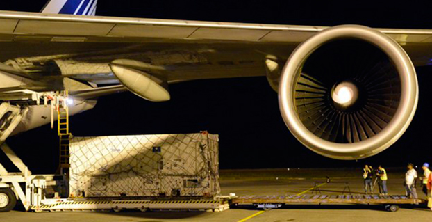
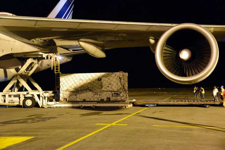
One of two Galileo satellites, safely in its protective container, is unloaded from an Air France Boeing 747 at Cayenne–Félix Eboué Airport in French Guiana.
News from the European Space Agency
Another two Galileo satellites have touched down in French Guiana ready to take their place in Europe’s satellite navigation constellation. The pair, safely cocooned inside their air-conditioned containers inside an Air France Boeing 747, landed at Cayenne–Félix Eboué Airport yesterday.
They were then taken by lorry to be installed in the cleanroom surroundings of Europe’s Spaceport to begin final preparations for launch.
The seventh and eighth Galileo satellites will be launched together by Soyuz in late March, resuming the interrupted building of the satnav constellation. The previous Soyuz launch saw the satellites released into the wrong orbit.
Galileo satellite in its protective air-conditioned container, about to be unloaded from the Air France cargo plane.
The reason for the malfunction has been pinned down to an installation error in the Fregat upper stage that delivers the satellites into their final orbits. A hydrazine fuel line was bracketed next to a liquid helium line, freezing the hydrazine and resulting in Fregat’s faulty orientation.
Arrival in French Guiana is the final stop in a complex production and test line that snakes back across Europe. The satellites are built by OHB in Bremen, Germany, with their navigation payloads coming from Surrey Satellite Technology Ltd in Guildford, UK, both companies being supplied in turn by subcontractors across much of the continent.
The complete satellites are then delivered to ESA’s ESTEC technical centre in Noordwijk, the Netherlands, home to Europe’s largest satellite test centre.
There, a series of tests reproduces every aspect of the space environment, including acoustic noise and thermal vacuum simulations, to ensure their readiness for space.
Each satellite is also plugged into the entire worldwide Galileo ground network for days on end to check it works as planned.
Their testing ended with a clean bill of health and they received clearance on Tuesday to travel to French Guiana. Loaded onto lorries on Wednesday, they arrived at Paris Charles de Gaulle Airport later that day, taking off for French Guiana on Thursday.
These two satellites are planned to be launched during last week of March, following the European Commission’s endorsement of the resumption of Galileo launches.
The seventh and eighth Galileo satellites were flown on this Air France Boeing 747 from Paris Charles de Gaulle Airport in France to Cayenne–Félix Eboué Airport in French Guiana on Feb. 5
Milena, or Galileo-FOC FM2, moves above the dangerous Van Allen Belt to rejoin Doresa, Galileo-FOC FM1, in a partially usable orbit. Photo: Galileo
By Tim Reynolds, GPS World European correspondent
Director General Jean-Jacques Dordain of the European Space Agency (ESA) announced Jan. 16 that the second errant full-operational capability (FOC) satellite, launched in August, had started its orbital change maneuver the previous day. He anticipated that the orbital change would be completed and the final orbit — “albeit somewhat lower in height than the one into which it was supposed to go” — achieved in “a few weeks.” He confirmed that both in-orbit FOCs work well, are fully operational, and provide excellent on-spec positioning data.
Two more FOC satellites are ready for launch, and a third has undergone thermal vacuum testing. Dordain said four will be available to launch soon, and he anticipated up to six FOCs being ready for launch in 2015 [word came at press time that all 2015 launches would be aboard the previously problematic Soyuz vehicle, and not on heretofore reliable Ariane]. The previous plan had called for four in 2015, but the total now includes two that were held back from a December 2014 launch. The actual schedule and launch vehicles are still under discussion, according to Dordain; the European Commission (EC) will make a decision at the end of January on this. He refused to comment on what ESA would recommend to EC on this front.
Read Tim Reynolds’ Brussels-based reporting the in EAGER quarterly enewsletter; free at gpsworld.com/subscribe.
The completion is a key milestone towards end-to-end capability to automatically transfer data between Raytheon’s OCX and Lockheed’s GPS III satellite. One more readiness exercise, five launch rehearsals, and a mission dress rehearsal are planned before launch of the first GPS III with OCX.
The exercise demonstrated mission planning and scheduling capabilities with the simulated Air Force Satellite Control Network (AFSCN) for the first time, including a replan scenario that would occur in the event of a launch slip.
The system also automatically generated antenna pointing angles for the simulated AFSCN — until now, manually generated. Exercise 4 introduced maneuver planning and reconstruction capabilities, as well as advanced planning and scheduling with AFSCN assets. Automation of these capabilities will allow GPS operators to optimize system performance rather than focus on routine operations.
Brigadier General Cooley
Colonel William Cooley, director of the GPS Directorate, has been nominated to the rank of brigadier general, United States Air Force. He wrote a December GPS World article on “What It Takes to Make a Gold Standard.”
Galileo, that’s who! For dogged determination and persistent pushing-forwardness in the face of adversity, obstacles, and the occasional technical difficulty. That there may be occasional confusion, as well, or mixed messages as to just what the future may bring, is certainly understandable. In fact, it is to be expected, given the circumstances.
Let’s review the math.
Two
Two for the two launch vehicles that Galileo may use in the near future, Soyuz Fregat and Ariane 5. The Soyuz rocket can lift two satellites of the Galileo punching weight. The Ariane 5 rocket can carry four into space.
Soyuz Fregat has a losing record so far with Galileo, being responsible for the August 2014 loosening of the first two full-operational capability (FOC) satellites into the dangerous Van Allen Belt. The first of these satellites has been successfully repositioned by the European Space Agency (ESA) into a mostly-but-not-totally useable orbit, and the second is currently en route to a similar spot.
We do not wish to say we told you so, but we will. Back on March 26, 2014, we wrote on these virtual pages, “ESA’s year-end plan calls for two more dual-satellite launches in October and December on Russian Soyuz rockets — new partners to the Galileo dance, bringing perhaps new technical connectivity issues.”
“Rockets are tricky,” said Tesla/SpaceX CEO Elon Musk, after his Falcon 9 Reusable rocket exploded over Texas at roughly the same time that Soyuz Fregat mis-delivered two Galileo satellites into wrong orbits.
Musk meant tricky in actual operation, but we may also add, tricky in scheduling, in getting a cargo aboard a spacebound vehicle. Arianespace’s calendar is particularly filled with telecomm satellites impatient to be put aloft, with Ariane 5 being the preferred launcher of many. Soyuz availability, understandably, is somewhat more open.
Four
Four for the total of four Galileo satellites now orbiting and broadcasting useable signals at all times for all users. These four come from the in-orbit validation (IOV) generation.
The two added FOC satellites, no longer in a bad orbit, now in a sort-of-pretty-good orbit, should be useable at some times, for some purposes, by some people. Peter Steigenberger and André Hauschild, researchers at the German Aerospace Center (DLR) / German Space Operations Center, wrote in this magazine in January that:
“Despite the orbit injection error, the new Galileo FOC satellite has now been successfully activated and added to the Galileo constellation. Unfortunately, the current orbit is incompatible with the standard Galileo almanac format, which may cause restrictions for some commercial receiver types.
“Nevertheless, the satellite can already be tracked by a wide range of geodetic receivers with existing firmware versions and it will, in fact, be possible to use the new satellite for diverse applications in surveying, precise positioning, and geodesy, as well as in general multi-GNSS studies. We now look forward to the activation of the second FOC satellite, which can be expected in early 2015 and will, for the first time, offer multi-frequency signals from a total of five Galileo satellites.”
If you have four fully useable satellites and two partially useable satellites, what do you have? Does six = five functionally in this case? Or perhaps 5.5?
Six
Six for the oncoming new Galileo FOC satellites to be launched in 2015, according to some schedules and some official announcements.
On a year-opening preview of operations given on Jan. 19, Thomas Reiter, Head of the European Space Operations Centre (ESOC) in Darmstadt, Germany, outlined the launch schedule for Galileo in 2015. Six new FOC satellites in total:
Galileo L4 with two on March 26
Galileo L5 with two in September
Galileo L6 with two in December.
Now, six satellites divided by three launch dates gives two satellites per launch. Seeming to indicate a Soyuz rocket for all three dates. Reiter did not mention any rocket by name, but this would be the inference.
That’s putting a brave face on the situation. Back in May, Russia suffered its fifth rocket launch crash in the past four years, raising serious concerns about the reliability of Russian rockets and launch procedures. Subsequently, the August Galileo launch that went so wrong was controlled by Arianespace, but it did use the Russian equipment.
It strains credulity that an omission or oversight in the system thermal analysis during stage design of a million-dollar rocket, designed to carry million-plus-dollar satellites in a 21st-century endeavor, could permit the creation of a thermal bridge between two feed lines, causing one of them to freeze during a crucial phase of space operations — but that is what apparently happened at some point at NPO Lavochkin in Russia, and that is what ultimately caused Galileo such misfortune. All parties concerned swear that this problem has been corrected in every other Soyuz Fregat, but who knows what other anomalies lie undiscovered therein?
So putting all your 2015 money aboard Soyuzes is really rolling the marbles. Even if, as Elżbieta Bienkowska, Member of the EC in charge of Internal Market, Industry, Entrepreneurship and SMEs stated at this week’s 7th European Space Conference: EU Space Policy Confronted With the Rising Demand for Services and Applications, “We agreed to contract insurance for the next launches.”
Eight
Eight for the oncoming new Galileo FOC satellites to be launched in 2015, according to other schedules and other official announcements.
“2015 will be a crucial year for the European space industry. We have big plans,” said Maros Sefcoviv, vice-president of the EC in charge of Energy Union, earlier at the very same 7th European Space conference, EU Space Policy Confronted With the Rising Demand for Services and Applications.
“On the biggest one, we are planning five launches, which will bring up to space 10 satellites: eight for our Galileo constellation, and two for Copernicus. This is something that will put these programs over, I would say, over the edge, in a way, to be able to offer early services from Galileo, and to develop the program of Copernicus. It would prove the resilience and competitiveness of the European space industry, and its ability to serve the businesses, and what I think is most important, to offer new kinds of services to the citizens.”
“For our flagship programs like Galileo and EGNOS, our priority must be to deliver services as soon as possible. That is why the satellites have to be delivered and operations must be ready as soon as possible.”
Now, if you have eight satellites to go up in three launches, that would mean one of them has to go with four aboard. Thus, an Ariane 5 Galileo launch this year after all? Or possibly four Soyuz launches, although one more launch date could just just as hard to come by as a launch vehicle.
Hard to tell. Very hard to tell. Extremely hard to tell, from the outside.
Those who do not study history are condemned to repeat it, goes the dictum. Those who do study GNSS history, in this case, are likely only to repeat past pronouncements without any perceptible advance in clarity.
Way, way back in March 2013, an EC program manager told GPS World, “Then, in 2014 [after four FOC satellites were to rise in 2013, which did not happen] we will see three Soyuz launches of two satellites each. We do not have the precise launch dates yet, but they are likely to be in April, June, and September. In December 2014, we expect to have the first launch using the Ariane 5 launcher, which is capable of deploying four satellites in one go. This means that by the end of 2014 Galileo will have deployed 18 satellites in orbit.”
Now, the target has moved several times since then, and the schedule has slid accordingly.
“In 2015, there will be two Ariane 5 launches, one in the middle of the year, one at the end, each carrying four satellites.”
Six or Eight?
Either number this year, we would surely appreciate. To return to Ms. Bienkowska, she left a little fudge room in her presentation: “We aim to launch at least six satellites this year.”
Well, at least we are all moving forward. Resolutely.
——————————–
I am indebted to Tim Reynolds, GPS World’s Brussels-based European correspondent, and to Peter de Selding, Paris bureau chief of SpaceNews, for their assistance in gathering diverse intelligence on this topic. Tim Reynolds will have an up-to-date view of this and other Galileo developments when we publish the next issue of the EAGER* newsletter at the end of March. Subscribe for free.
Operators of Galileo’s Ground Mission Segment at the Galileo Control Centre in Fucino, Italy. These operators oversee the navigation services of the Galileo constellation. Photo: Galileo
Galileo’s navigation messages will shortly stop being updated to enable the migration of a new release for Galileo’s ground mission segment, announced the European Space Agency.
Although the actual navigation signals will continue to be transmitted, the generation and uplink of the navigation message — which renews the contents of the signal — will be interrupted during the last week of January for about five weeks.
The accuracy of the navigation message received by users will slowly degrade, or in case of a reset in the satellite signal generator the message content will be dummy material. The users will be informed accordingly through a warning flag in the disseminated message, or through the online Notice Advisory to Galileo Users.
“The main benefits of this migration from V1.2 to V2.0 of the Galileo Ground Mission Segment are better overall performance and availability, increased robustness and improved operability,” explained ESA’s Martin Hollreiser, who is overseeing the mission segment’s development with Thales Alenia Space France as prime contractor. “The latter is achieved through enhanced operator interfaces, increased access to performance data and the automation of procedures.
“Various ‘non-conformances’ identified by operators over time have been fixed, while overall security has been further strengthened through treatment plans,” Hollreiser said. “This is in particular true for the Public Regulated Service, or PRS, the most secure Galileo class of signal. Finally, the number of Galileo Sensor Stations will increase from 12 to 15 worldwide and the number of Galileo Uplink Stations from four to five.
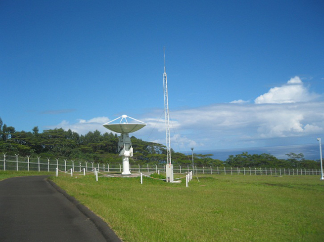
“The new Sensor Stations will be on Santa Maria in the Azores, Ascension Island in the mid-Atlantic and Kiruna in the Swedish Arctic. The additional Uplink Station will be on Papeete, in French Polynesia. Such system improvements have always been part of our planning since the contract began in 2011.”
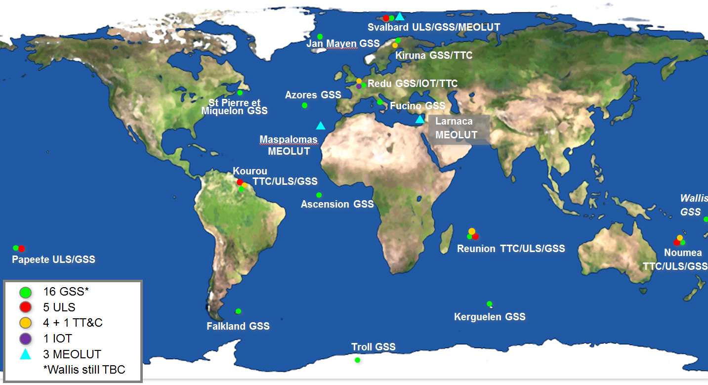
Galileo’s worldwide ground mission segment is one of the most complex developments ever undertaken by ESA, with twin European Galileo Control Centres and a network of sensor and uplink stations deployed on remote sites across the world. They are all interconnected via a robust satcoms realtime network.
While satellite control and housekeeping are performed by Galileo’s Ground Control Segment in Oberpfaffenhofen, Germany, the Ground Mission Segment that provides the navigation and timing services and related performances is operated from a separate centre in Fucino, Italy.
Galileo’s ground segment encompasses twin European Galileo Control Centers and uplink stations on remote sites across the world. They are all interconnected via a robust satcom network. It includes Galileo Sensor Stations (GSSs) to provide coverage for clock synchronization and orbit measurements; uplink Stations (ULSs) to uplink navigation and integrity data to the Galileo satellite navigation payloads for rebroadcast to users; Telemetry, Tracking and Command Stations (TT&Cs) to manage the satellite platforms; an In-Orbit Test (IOT) site at Redu for satellite payload testing and a trio of Medium-Earth Orbit Local User Terminals (MEOLUTs) for search and rescue activities.
A user’s satnav receiver needs signals from at least four satellites. It actually measures the time the signal takes to reach its antenna from the satellites, then converts time into distance to compute its spatial position as the intersection of the four resulting spheres. To reach sufficient level of precision, the time synchronization of the overall system clocks must stay accurate to a few billionths of a second, and any drift in satellite orbits must be corrected for.
This is the task of the Ground Mission Segment in the control center, which continuously receives signal measurements from the sensor stations around the world. Based on these measurements, it computes exact satellite orbits and time synchronization for the satellites’ onboard atomic clocks.
These corrections are incorporated into the ephemerides included in an updated navigation message, which is uplinked to the satellites for dissemination to the user. The updated ephemerides information in the navigation signal provides to the user receivers the information required to compute their exact position.
The new Papette Uplink Station in Tahiti, French Polynesia, used for uplinking navigation messages for rebroadcast to users from Galileo satellites. Photo: Galileo
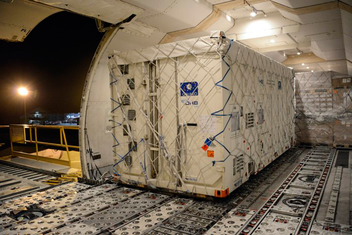
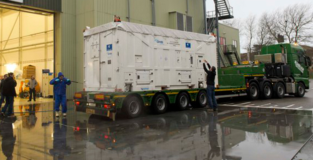
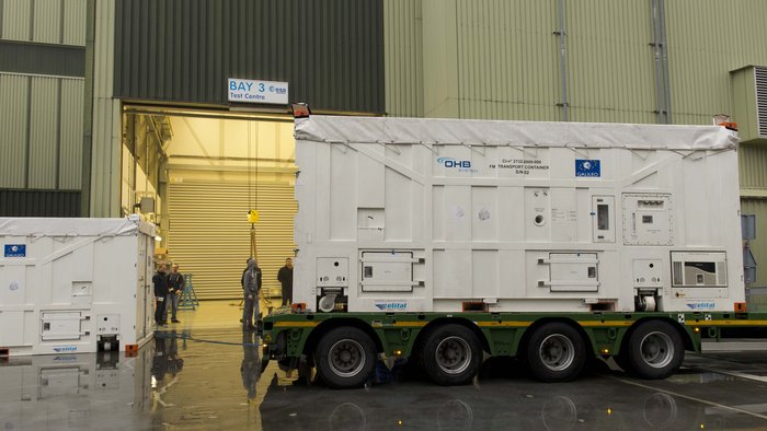
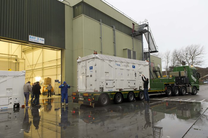
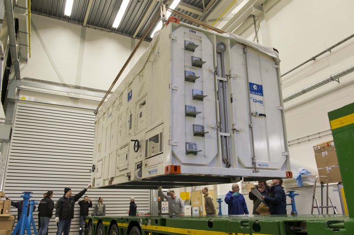
The latest Galileo satellite, formally known as FOC FM06, arrived at the ESTEC Test Centre in its protective container on Dec. 18, after traveling from OHB in Bremen, Germany. Photo: European Space Agency
The latest Galileo satellite has arrived at ESTEC, in the Netherlands, and is undergoing a full checkout to prove its readiness for space.
The satellite was carried by lorry from its manufacturer in Germany, cocooned within an environmentally controlled container. It arrived inside ESTEC’s cleanroom environment on Dec. 18. The container was then opened up to begin preparations for testing.
The first six Galileo satellites are already in orbit, launched in pairs in 2011, 2012 and August this year.
The last pair was delivered into the wrong orbit by a faulty upper stage, but the fifth satellite’s orbit has since been changed to allow checking of its navigation payload, which began at the end of November.
The sides and top of the Galileo satellite container were sprayed clean before it was taken inside the bay of the ESTEC Test Centre to keep any contamination from entering the pristine cleanroom. Photo: European Space Agency
Meanwhile, down on the ground, production of further satellites continues steadily, taking the Galileo series into double figures overall.
Following on from the first four In-Orbit Validation satellites, 22 of these Full Operational Capability satellites are being built by OHB in Bremen, Germany, with navigation payloads from SSTL in Guildford, UK.
Numbered Flight Model 6, or FM06 for short, this latest of the newer satellites is now reunited under the test centre’s roof with three others. FM03 and FM04 have completed their acceptance testing, culminating in the weeks-long thermal-vacuum test. Each satellite was subjected to the same vacuum and extreme temperature conditions experienced in orbit, as well as radio-frequency testing of their navigation payloads and antennas inside an anechoic chamber isolated from the external universe. This pair is now in storage in the centre pending the results of their concluding acceptance review.
The other satellite, FM05, recently ended its own thermal-vacuum trial. It is now being reconfigured for radio-frequency testing, planned to take place after the Christmas break. The latest unboxed Galileo satellite will undergo its own thermal–vacuum test in January.
ESTEC is an essential stop on the way to space for Galileo. It is equipped with all the facilities needed to simulate space conditions under a single roof, including an acoustic chamber, earthquake-strength shaker tables, and anechoic and vacuum chambers, along with a range of specialised measuring equipment.
Once ESTEC gives the satellites its stamp of quality then they are in principle ready to be flown to Europe’s Spaceport in Kourou, French Guiana. ESA and the European Commission are currently deciding on the launch schedule for these next Galileos.
The container containing the latest Galileo satellite, FOC FM06, was carefully hoisted off the lorry that carried it from OHB in Bremen, Germany. Its underside was then carefully cleaned before it was taken out of the bay into the cleanroom environment. Photo: European Space Agency
By Ugo Celestino, European Commission, Antonella Di Fazio, Telespazio SpA, Vicente José Giner Herrera, Ineco, Patrizio Vanni, ENAV SpA, and Francisco Javier Deblas, ESSP.
This article describes a live demonstration of an aviation application in Tunisia, to help the local aviation community in validating the use of the European Geostationary Navigation Overlay Service (EGNOS) to guide airplanes during landing operations. This activity constitutes the first complete experience of EGNOS Safety of Life (SoL) service for aviation approaches outside Europe. We present here the obtained results that are useful not only for Tunisia, but as a valuable case study for other countries outside Europe interested in using EGNOS in aviation.
EGNOS, operational since 2009, has a European regional coverage that could be quite easily extended to areas adjacent to European Union through the deployment of limited additional ground infrastructure elements, but sharing the same existing space segment and leveraging the other core ground infrastructure.
The European Commission has put in place a series of actions since 2006 to support the EGNOS service extension in neighbouring areas. The MEDiterranean follow-Up for EGNOS Adoption (MEDUSA) is an on-going European initiative related to EGNOS extension in the Euromed region, including North African and Middle East countries around the Mediterranean basin: Algeria, Egypt, Israel, Jordan, Lebanon, Libya, Morocco, Palestine, Syria, and Tunisia. MEDUSA runs a program of technical assistance action in these Euromed countries, in order to prepare them for an optimal adoption and exploitation of European GNSS services in their priority market segments.
The Mediterranean Extension of EGNOS
EGNOS is Europe’s first venture into satellite navigation and paves the way for Galileo, Europe’s independent global satellite navigation system currently under deployment.
EGNOS is a satellite-based augmentation system (SBAS), whose signal is compliant to the international SBAS interoperability standards: standards – MOPS (Minimum Operational Performance Standards) and ICAO SARPs (International Civil Aviation Organization Standard and Recommended Practices). In its current version (V2) it augments the open public service offered by the American Global Positioning System (GPS), by providing correction data that enables to improve GPS position accuracy, and provides integrity information about the GPS system (integrity information is fundamental for aeronautical applications like approaches). EGNOS is interoperable with the other equivalent regional systems. Today other SBASs are the U.S Wide Area Augmentation System (WAAS), the Japanese Multi-functional Satellite Augmentation System (MSAS), the Indian GPS Aided Geo Augmented Navigation (GAGAN) and the Russian System for Differential Correction and Monitoring (SDCM). The future version (V3) of EGNOS will augment Galileo signal as well.
Today EGNOS is operational, and available for use in aviation since 2011, giving opportunities for users to have more accurate and reliable positioning for enhancing existing applications, developing new applications and particularly the safety critical ones. Already more than 150 landing procedures are operational across Europe (some of them also in countries out of the European Union, such as Switzerland, Norway, Guernsey), with many others under development to reach 100 percent Approaches with Vertical Guidance (APV) coverage in the European instrumental runways as per ICAO recommendation.
EGNOS provides three services:
EGNOS Open Service (OS), launched in 2009, is delivered free of charge. It is open for use to anyone with an EGNOS-enabled receiver. This can be any receiver compatible with satellite-based augmentation systems. Being based on GPS, the EGNOS signal does not require major changes for receivers. Today, many mass market receivers available on the market are also EGNOS enabled. EGNOS OS is particularly suitable for mass market and some applications like surveying.
EGNOS Safety-of-life Service (SoL) is authorized for European civil aviation and operational since March 2011. EGNOS SoL delivers the integrity message providing the verification of the GPS system and timely warnings (within six seconds), when the system or its data should not be used for navigation. Since integrity relates to the trust that can be placed in the correctness of the location information supplied by GPS, thanks to this feature EGNOS is able to meet the demands of safety-critical applications in sectors such as aviation.
EGNOS Data Access Service (EDAS) launched in 2012, delivers a terrestrial commercial data service. It consists of a server that gets the data directly from EGNOS system and disseminates it via terrestrial networks in real time, within guaranteed maximum delay, security and performance. EDAS is particularly suitable for professional applications. It provides EGNOS raw data and corrections enabling software solutions that implement products and value added services built on them.
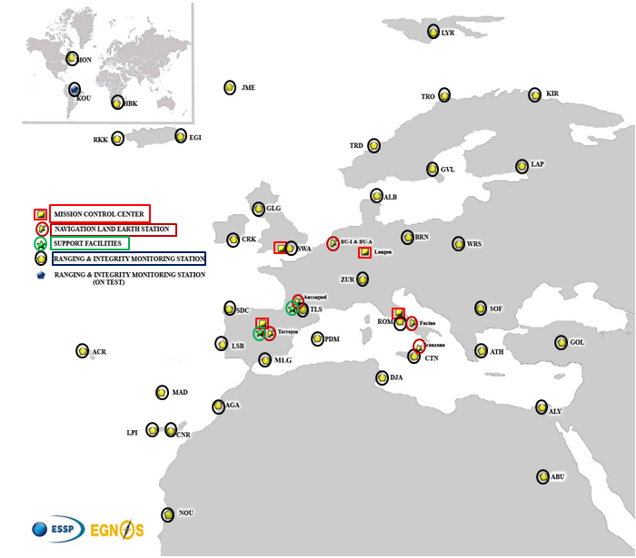
EGNOS infrastructure consists of three geostationary satellites over Europe and a network of ground stations (Ranging and Integrity Monitoring Station – RIMS) located to provide services whose coverage includes southern Europe, North Africa and some Middle East countries.
The EGNOS RIMS network supports a flexible network geometry that gradually adapts to service coverage requirements evolution. From the originally envisaged coverage over European Union’s countries, the EGNOS RIMS network is being expanded over Europe’s neighbouring areas, thus increasing the number of beneficiary countries. EGNOS SoL service is highly sought by several non-EU countries for the benefits it can bring to their civil aviation, in providing a solution to comply with ICAO requirements for Performance Based Navigation (PBN).
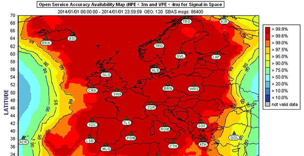
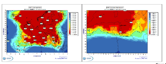
The present layout of the EGNOS RIMS network is presented in Figure 1.
Figure 1. EGNOS ground segment.
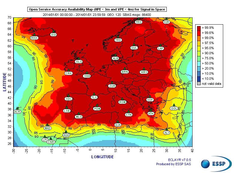
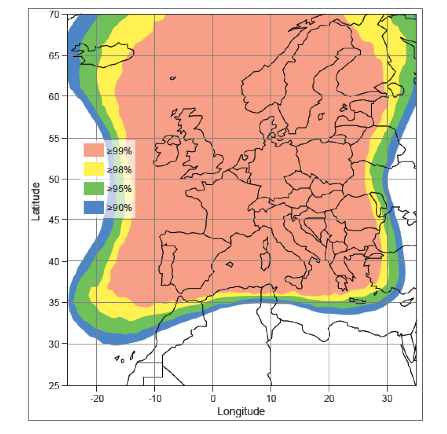
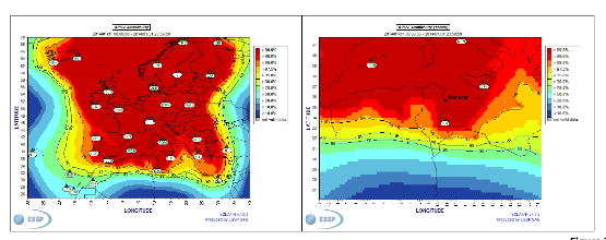
Figures 2 and 3 show respectively today’s coverage of EGNOS OS availability (source: European Satellite Services Provider, the service provider of EGNOS) and the APV-I availability performance commitment provided by EGNOS SoL (source: EGNOS Safety of Life Service Definition Document, EGN-SDD SoL, V2.0, European Commission, 2013), obtained relying on the above presented ground segment.
Figure 2. EGNOS OS Availability.
EGNOS OS Availability. The Figure 2 map is obtained by projecting the error at pseudorange level into the position domain. The computed error assumes that the GPS satellites used are those with an elevation angle above the local horizon (with a mask angle of 5º) and does not consider any possible factor depending on local characteristics that could produce different results (optimistic or pessimistic) with respect to the results computed using real receivers located in the considered areas. Moreover, it represents an estimation of EGNOS OS availability during a very limited period of time being an estimation, thus it does not imply any commitment or reference for the performances which can be obtained during different periods.
Figure 3. EGNOS APV-I Availability.
Other initiatives for a further extension in North Africa and Middle East are already being developed, under the umbrella of the Euromed GNSS programme. In parallel with the infrastructure deployment, the Euromed GNSS programme also includes actions to support the introduction and exploitation of EGNOS services. The first stage was completed in the frame of the Euromed GNSS I/MEdiTerranean Introduction of GNSS Services (METIS) project in the period 2006-2009, the second stage is presently running in the frame of the Euromed GNSS II/MEDUSA project. Further initiatives are being planned for 2015 and beyond.
EGNOS Use in Aviation
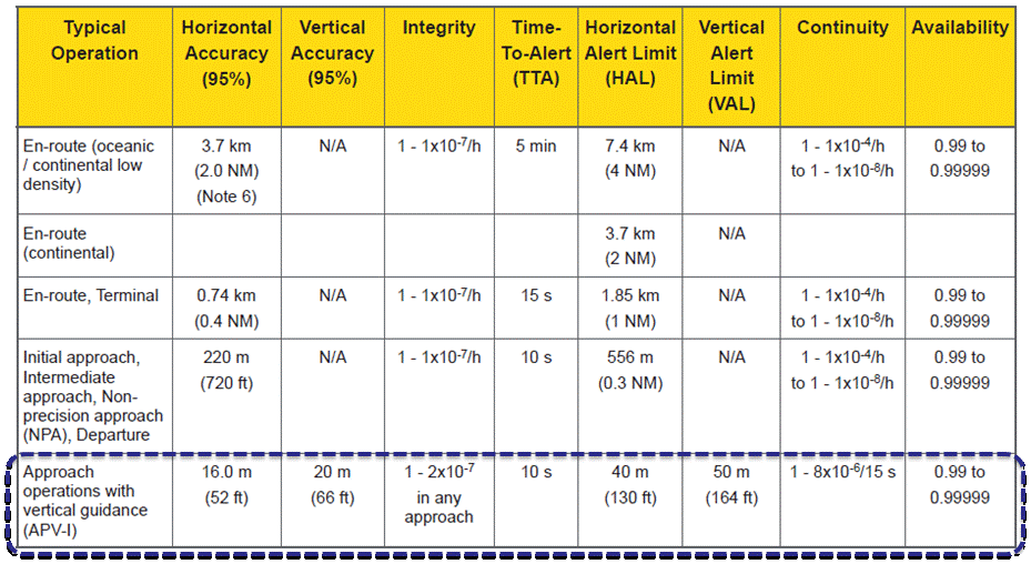
EGNOS was initially designed and developed to be used in aviation, similarly to the U.S. Federal Aviation Administration WAAS, to support different types of aviation applications and, in particular, to meet the performance requirements set by the International Civil Aviation Organization (Annex 10) for the implementation of APV-I, which enable the implementation of LPV final approaches, as reported in Table 1.
Table 1. ICAO Operational Requirements.
EGNOS is one of the GNSS elements recognised by ICAO (Annex 10) as a radionavigation aid. It is an important element of a global SBAS systems mosaic, that started with the American system WAAS in 2003, and that is gradually completed by other more recent SBAS: EGNOS itself, MSAS (Japan), GAGAN (India), SDCM (Russia), and some countries like Australia and South Korea that have launched feasibility studies to develop their own SBAS.
It is expected that, in a not too far future, most parts of the world will profit from SBAS services, following the current coverage extension plans and SBAS system evolutions. The final objective, as also shared at ICAO level, is that as many airdromes worldwide, as possible, can offer instrument approaches with vertical guidance, with an outstanding increase in global safety rates.
Additionally, the use of EGNOS allows taking full advantage of GNSS for all phases of flight, including final approach. Therefore, EGNOS means for aviation a fundamental and strategic tool to help meet ICAO’s recommendations, aimed at the adoption of a PBN oriented airspace use policy, for all countries. The 37th Assembly of ICAO (28 September – 8 October 2010) resolved that APV procedures should be implemented as either a primary or backup strategy for precision approaches at all instrument runway ends by 2016.
APV is a major safety initiative. ICAO recognises SBAS and Barometric Vertical Navigation (Baro-VNAV) as the two acceptable (and often complementary) means of implementing APV procedures, which are safer than NPA (Non Precision Approach).
GNSS based navigation enables RNAV (aRea NAVigation) with a higher cost effectiveness in comparison with the old conventional, sensor ground-based, navigation procedures. This is especially true for wide, even desert unequipped areas (or difficult to maintain) like those in North Africa and Middle East.
EGNOS benefits are maximized in final approach manoeuvres, providing GNSS lateral and vertical guidance, and enabling APV-I approaches.
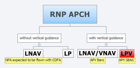
Final approach procedures based on GNSS are classified as RNP approaches (RNP APCH, as shown in the next figure), namely: Lateral Navigation (LNAV) with GPS lateral guidance and no vertical guidance; LP with GPS + SBAS (EGNOS) for lateral guidance (CAT-I localizer performance) and no vertical guidance; Lateral Navigation/Vertical Navigation (LNAV/VNAV) with GPS lateral guidance and Baro-Vertical Navigation (VNAV) vertical guidance (Baro-VNAV approach procedures can be flown with SBAS vertical guidance upon the approval of the Air Navigation Service Provider (ANSP)) and the LPV (Localizer Performance with Vertical Guidance) with GPS + EGNOS for both lateral and vertical guidance.
Figure 4. RNP approaches.
Those procedures not including vertical guidance are intended to be flown with the Constant Descent Final Approach (CDFA) technique (to avoid dangerous dive and drive practices), supported by most Flight Management Systems (FMS).
Regarding the operational LPV main figures, the European regulation (EU OPS -REGULATION (EC) No 859/2008 usually known as EU OPS) allows LPV operational minima (Decision Height – DH) down to 250 ft, expected to be possibly lowered down to 200 ft by 2015 (LPV-200), similarly to what is already permitted by the FAA, in the United Sates for WAAS based LPV approaches (a DH of 200 ft would make LPV approaches very competitive, when benchmarked against ILS CAT-I, precision approach, or even Ground Based Augmentation System (GBAS) CAT-I precision approach).
In the last few years, about 150 LPV procedures (status as of July 2014) have been published in European airports, and the number of procedures and countries introducing EGNOS is continuously increasing.
Euromed GNSS I/METIS and Euromed GNSS II/MEDUSA
In parallel with the development of the infrastructures necessary for extending EGNOS availability across the Euromed region, the European Commission has put in place initiatives to prepare and assist the Euromed countries for the optimal use and adoption of the relevant services.
These consist in two sequential projects, the first being Euromed GNSS I/METIS project and the second being Euromed GNSS II /MEDUSA.
Running from mid 2006 up to the end of 2009, METIS acted as a pioneer in the Euromed countries and built national/regional liaisons with decision-makers and key stakeholders, interested in sharing experience and absorbing know-how. The project assisted the 10 Euromed countries to identify their priorities in relation to the use of EGNOS services, to validate the relevant opportunities from the strategic/social and economic perspectives, and to elaborate a suitable strategy and a plan of actions for facilitating EGNOS adoption and exploitation.
MEDUSA Case Study in Tunisia: LPV Approaches in the Airport of Monastir Using EGNOS
As part of the technical assistance actions programme in the priority domains, MEDUSA implements demonstrations and validations of EGNOS services in concrete applications.
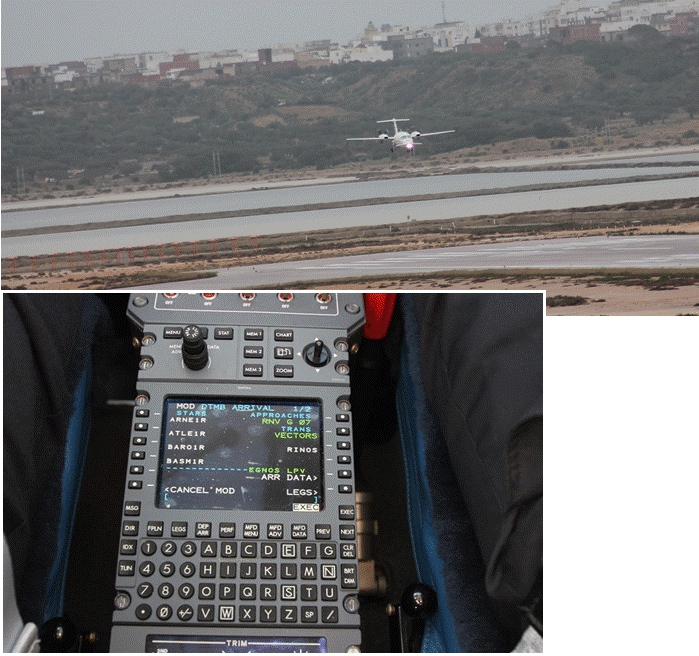
For EGNOS SoL, the technical assistance action consisted in the validation of GNSS approaches, including LPV approaches, designed and constructed in MEDUSA along with the relevant safety assessment and business case for the airport of Monastir in Tunisia (35°45’29’’ N 10°45’17’’ E). The selection of the airport was driven by a trade off between the EGNOS service availability with required APV-I performances and the specific needs of the Tunisian Air Navigation Service Provider – ANSP (OACA, Office de l’Aviation Civile et des Aéroports). According to OACA, Monastir is among the airports in Tunisia presenting favourable conditions, in terms of operational constraints and traffic, for concretely proving the added value of EGNOS for final approaches.
The airport has two runways, RWY 07 and RWY 25, the former is equipped with an ILS CAT-I, the latter only supports NPA approaches. The installation of an ILS in RWY 25 was discarded due to technical constraints. This infrastructure has proven to be insufficient to fully cover the airport needs, that suffers some Delays-Diversions-Cancellations (DDCs) as a result of local specific meteorological conditions, frequent fog banks entering from the sea in the early morning, combined with desert haze. These conditions make LPV ideal procedures, as backups to RWY 07, and enabling APV approaches to RWY 25. Finally, Monastir’s TWR ATC (Tower Air Traffic Control ) staff has been involved in OACA’s PBN development, for which they were ideal candidates to evaluate the benefits possibly achievable from the use of EGNOS.
This MEDUSA’s technical assistance action is the first complete experience for the use of EGNOS SoL service outside Europe. It was conceived as a realistic exercise of RNP APCH procedures implementation, following the guidelines provided by ICAO in the “EUR RNP APCH Guidance Material (EUR Doc 025)” and including all the activities required, from the scenario adequacy study to flight validation and the requirements analysis for the final publication in the AIP (Aeronautical Information Publication). OACA was directly involved in all activities, providing inputs/feedbacks and for training purposes.
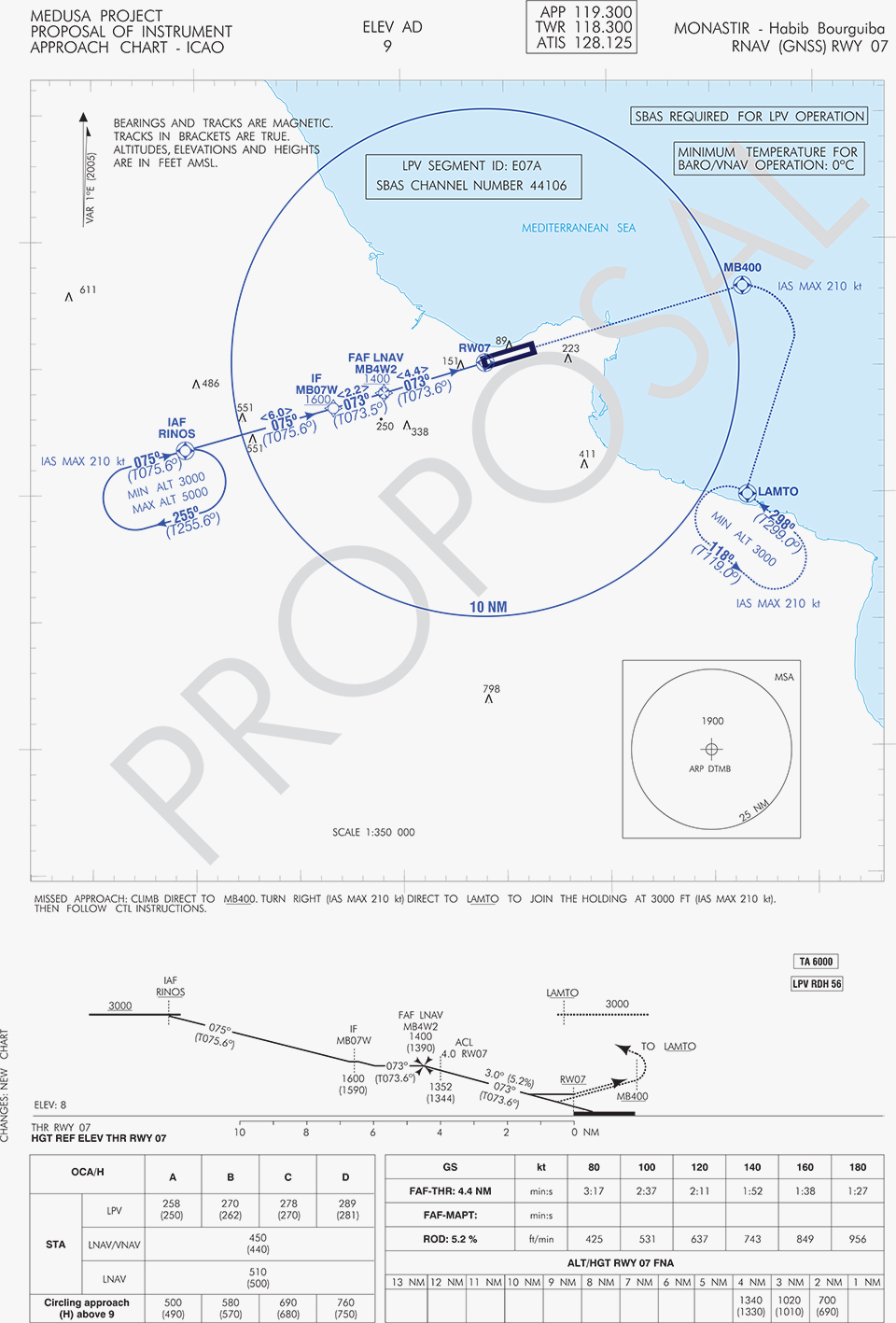
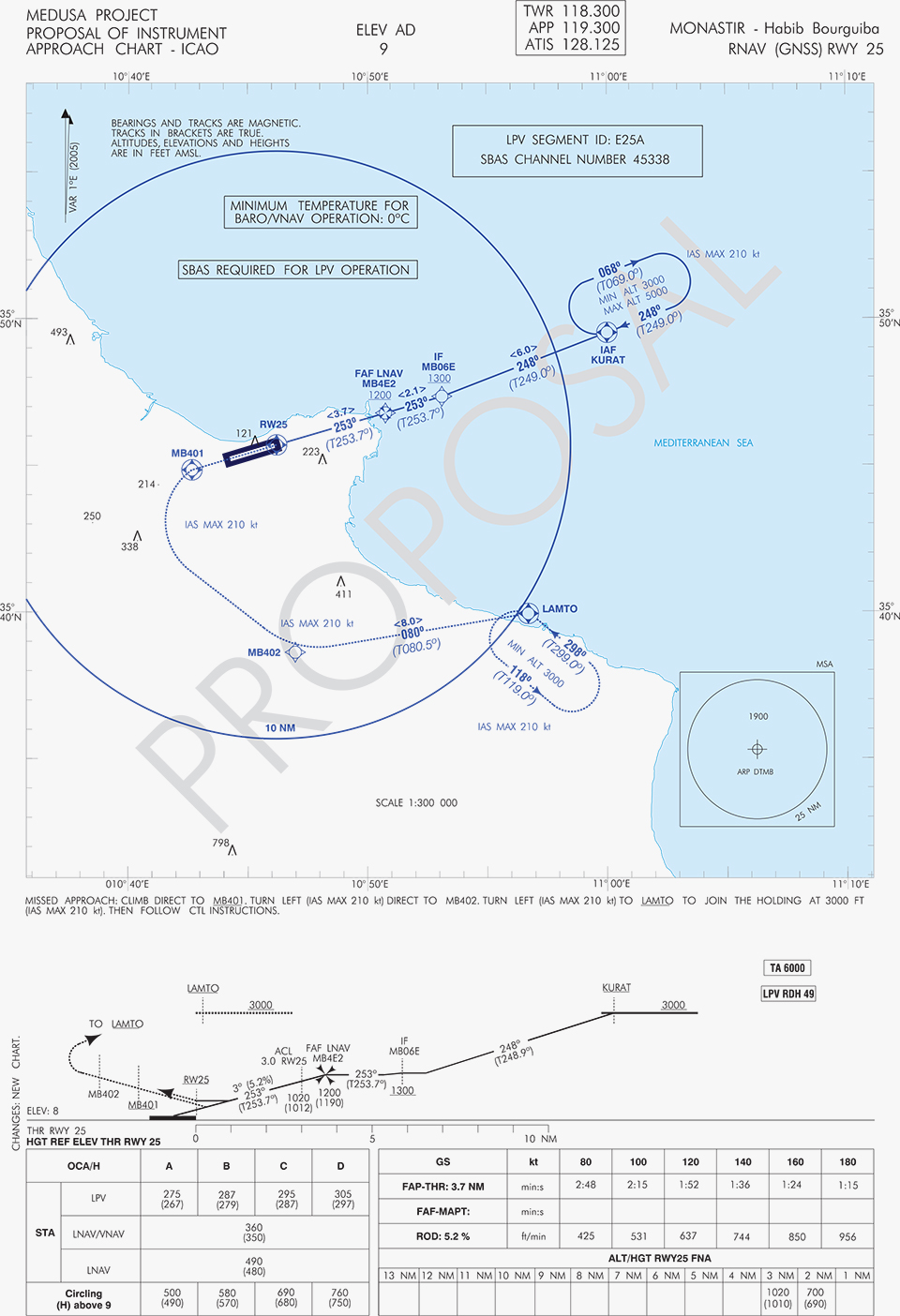
A set of three GNSS based approach procedures was produced for each RWY, following ICAO 8168 PANS OPS design principles. The next figures show the combined charts type elaborated, that include minima boxes for three RNP approaches (LNAV, LNAV/VNAV and LPV). The procedures construction preserves the current Monastir arrivals structure, following airspace management principles and facilitating the operational approval. As illustrated in the charts, in both cases for the three minima the calculated OCH (Obstacle Clearance Height) values improve with respect to the already existing conventional approaches, providing significant operational and safety benefits.
Figure 5. GNSS approaches for RWY 07.Figure 6. GNSS approaches for RWY 25.
An on-site GNSS performance monitoring campaign was performed by OACA, with the support of GEMCO’s staff, 3 months before the flight trials schedule, covering both EGNOS and GPS signal performances. Besides, an APV-I availability study for the area and specifically for Monastir airport during 1 month before the flight validation was purposely elaborated by the European EGNOS service provider (ESSP). Both analyses, confirmed suitable APV-I performance in terms of availability and continuity, making feasible the implementation of LPV approach procedures in line with ICAO prescriptions.
The next figures show the EGNOS APV-I availability and continuitymeasured on one day during the period of the flight validation (conducted from 30 January to 1 February 2014), in particular at Monastir airport for the considered time-lag:
APV-I availability was over 99%;
APV-I continuity presented a total value lower than 5×10⁻⁴/15s;
95th percentile of Horizontal APV-I accuracy was between 1.1 and 1.2 meters and the 95th percentile of Vertical APV-I Accuracy is around 1.4 meters, thus showing a very good accuracy level;
Horizontal and Vertical safety indexes were lower than 0.25, representing a very good integrity margin.
Additionally, the results of the on-site GNSS performance monitoring campaign showed quite stable performances with small fluctuations during the whole period of observation, and no problems or outages were observed.
(EGNOS APV-I Availability is defined as the percentage of epochs in a month in which the Protection Level are below Alert Limits for this APV-I service (HPL<40m and VPL<50m) over the total period (source: ESSP).
EGNOS APV-I Continuity Risk is defined as the result of dividing the total number of single continuity breaks using a time-sliding window of 15 seconds by the number of samples with valid and available PA navigation solution. A single continuity break occurs if the system is available at one epoch and becomes not available for the following 15 seconds (source: ESSP).)
Figure 7. APV-I availability on 31.01.2014.Figure 8. APV-I continuity on 31.01.2014.
The flight validation campaign was carried out according to ICAO doc 9906 with a Piaggio P180 Avanti II (from ENAV flight inspection department) suitably equipped with UNIFIS 3000 system and a Rockwell Collins FMS 3000 with SBAS LPV approach capabilities.
Figure 9. Piaggio P180 Avanti II aircraft and the FMS messages during the flight validation.
The outcomes of this concrete experience have allowed the Tunisian authorities to identify the main elements for the publication of the validated procedures in their national AIP. They have also contributed to the analysis of the necessary process for the operational adoption of GNSS, including EGNOS, in aviation in countries beyond the EU boundaries.
The activities performed on performance assessment have been preparatory for discussions on GNSS monitoring and data recording on going at ICAO Navigation System Panel level, that would produce ICAO guidelines for States.
Therefore, this Tunisia’s “case study” represents a practical and realistic example that could be beneficial for the other non-EU countries in terms of best practice and lesson learnt. Moreover, methodology and guidelines have been derived to be possibly injected to other non-European countries interested to introduce EGNOS operations in aviation.
Lessons Learned and Outlook
Through its achievements, MEDUSA is opening the way for the introduction of EGNOS SoL service in North Africa and Middle-East region, and it is also defining a suitable path to be followed by other interested non-European countries. Overall, MEDUSA is continuing to confirm the ability to foster cooperation and involvement in EGNOS programme of the great majority of the Euromed countries. Further to Tunisia, other Euromed countries have already expressed their interest in relation to the EGNOS use in aviation, considering each country’s strategy and also in the light of a common shared regional perspective. Besides, the results obtained by MEDUSA are useful also for other regions interested to use EGNOS in aviation.
Additionally, MEDUSA is clearly showing that Euromed region, presently lacking the full support of SBAS technologies, represents an opportunity for EGNOS service extension, with many benefits for the countries of the region and for Europe.
On one hand, being SBAS an effective and efficient technology to enable the aviation community of the Euromed countries to comply with ICAO recommendations on PBN implementation by year 2016 across the region, the services coverage extension of existing SBAS systems (EGNOS in the case of the Euromed countries) can be one of the most efficient ways to move forward. In fact, the Euromed national ANSPs consider the readiness of EGNOS SoL service as one of the main drivers and factors when designing their PBN strategy. EGNOS, which is already operational since 2009 and available for use in aviation since 2011, can deliver added-value services to the Euromed region, just by leveraging the existing European infrastructure with only incremental, marginal and natural extension. The EGNOS coverage extension across the Euromed region can provide significant benefits and particularly to those Euromed countries with few ILS or reduced navaids coverage, and enhance safety and efficiency to the whole aviation community.
On the other hand, the European Union has to gain from an EGNOS-based long term links with its neighbouring regions, by increasing bilateral/multilateral cooperation and interaction (e.g. assistance, mutual cooperation) among public and semi-public bodies (e.g. ANSPs, Civil Aviation Authorities), by strengthening EGNOS SoL coverage in the southern/peripheries of EU (e.g. Malta, Cyprus, Greece, Southernest Italian islands, Canary islands), by pursuing and supporting other EU policies in several sectors (like transports, e.g. harmonizing aviation safety standards across the Mediterranean, Transport Policy of the Mediterranean Partners), and last but not least by achieving a first step towards EGNOS extension to the whole African continent which will bring in similar, additional benefits just described above.
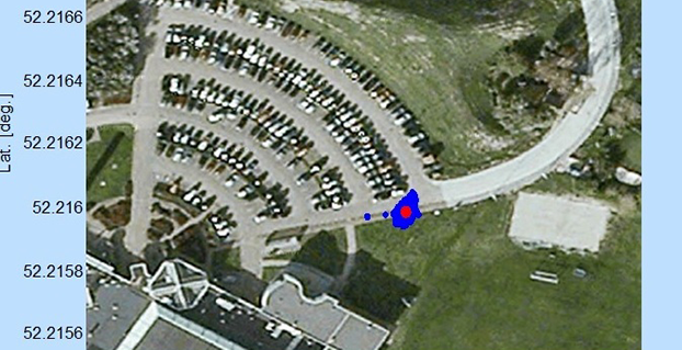
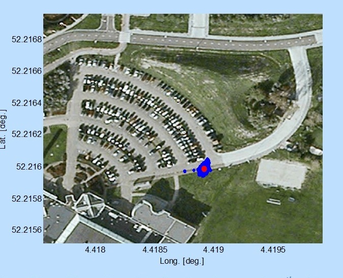
Scatter plot of the Galileo fix performed in ESA’s Navigation Laboratory at its ESTEC technical centre on 9 December 2014. The plot was calculated by the Lab’s Septentrio Test User Receiver, with dispersion of less than 2 m.
News from the European Space Agency
Galileo’s fifth satellite — recently salvaged from the wrong orbit to begin navigation testing — has been combined with three predecessors to provide its first position fix.
Test receivers at ESA’s technical centre in Noordwijk, the Netherlands, and at the Galileo In-Orbit Test station at Redu in Belgium received the signals at 12:48 GMT on December 9 from the quartet of satellites and fixed their horizontal positions to better than 2 meters.
This achievement is particularly significant because the fifth satellite is the first of a new design of 22 Galileo satellites set to be launched over the next few years.
Further position fixes were then made by France’s CNES space agency in Toulouse, France, as noted by Bernard Bonhoure: “The results are as good as those for the first Galileo fixes in 2013 with the initial four satellites.”
The following day, fixes were performed using Galileo’s Public Regulated Service, the encrypted highest-precision class of signal.
“The very good geometry of the satellites in the sky relative to the receivers helped us to achieve this result, plus the signal strength of the fifth satellite,” explained Gustavo Lopez Risueno, coordinating the receiver team at the Navigation Laboratory in ESA’s ESTEC technical centre.
“This is a significant milestone for the Galileo program because it marks the very first time that a Full Operational Capability satellite has performed a fix together with its In-Orbit Validation predecessors — which were the first four satellites launched into orbit, in 2011 and 2012. This establishes they work together well.
“While it is not yet possible to make routine use of the fifth Galileo, this shows such an outcome is within our reach.
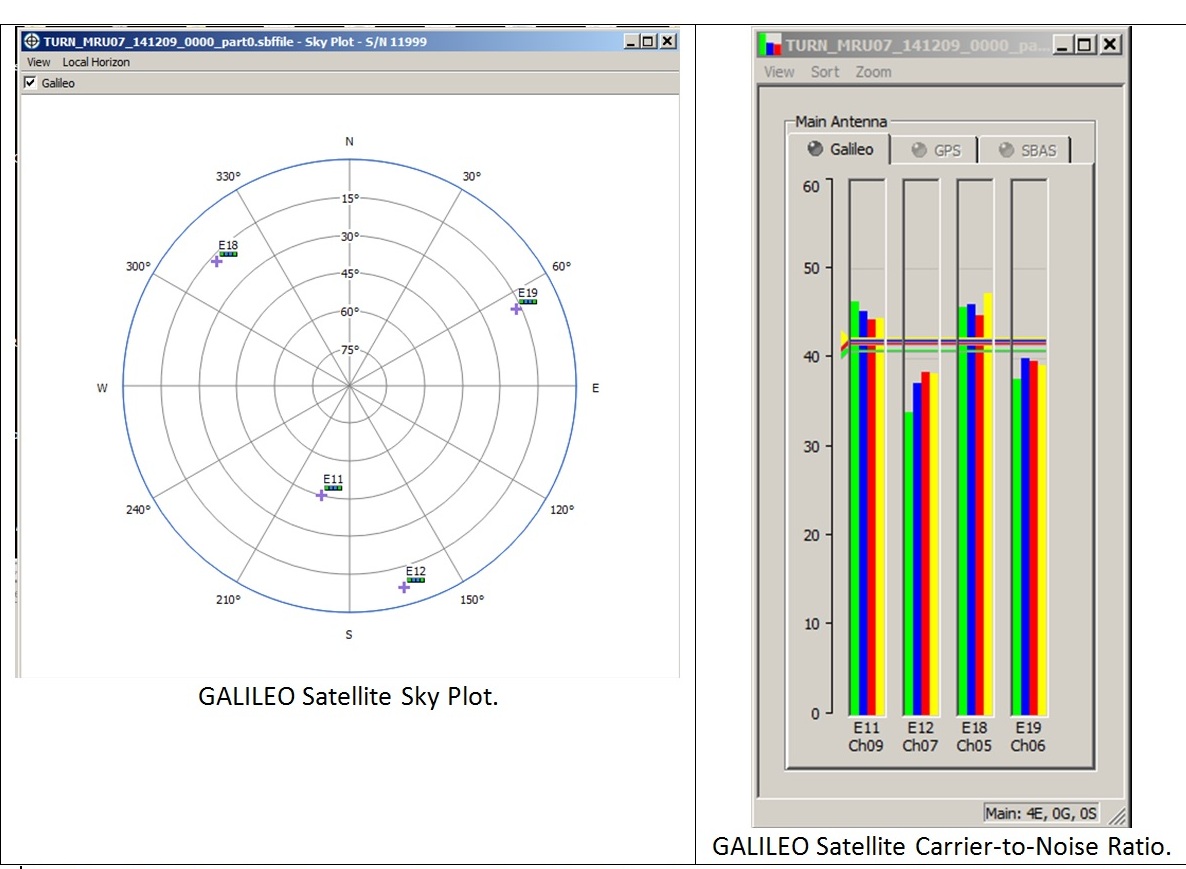
Galileo satellite geometry and received signal strength for the December 9 fix using the first Galileo FOC satellite. The first Galileo FOC satellite corresponds to E19 on the left display; IOV PFM to E11, FM2 to E12 and FM3 to E19.
“In particular, it opens the door to its immediate use in combination with additional navigation message information provided through ground networks, which is a standard mode of operation for mass market receivers, such as those found in our smartphones.”
The fifth and sixth satellites were delivered into the wrong orbit by their Soyuz–Fregat rocket in August. Their elongated orbit took them out to 25,900 km above Earth and back down to 13,713 km, rather than the planned circular path at 23,222 km. The angle of the orbit to the equator was also wrong.
The satellites’ shifting altitude left them unable to lock onto Earth for part of each orbit, preventing them from being used for navigation purposes.
But, last month, a series of 11 maneuvers took the fifth satellite into a more circular orbit, some 3500 km higher, allowing its navigation payload to be switched on for testing. A similar salvage operation is planned soon for its companion.
The main hurdle in using the fifth (and subsequently sixth) satellite operationally is that mass market receivers in particular might take longer to find it. Their orbits fall outside the almanacs satellite-locating standard broadcast within navigation messages.
Utilizing navigation-assistance information would be a way of shortening acquisition times — and ESTEC’s Navigation Laboratory has already demonstrated it with mass market receivers.
Working in conjunction with the European Commission and Europe’s Global Navigation Satellite Systems Agency, the Lab performed position fixes with both Galileo and GPS satellites using only navigation-assistance information.
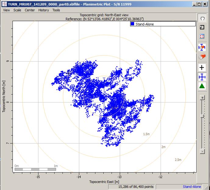
Test position fix in the grounds of ESTEC, performed with a mass-market receiver using navigation-assistance information, based on signals from the fifth Galileo satellite plus GPS satellites. This satellite’s elliptical orbit means extra data are needed to speedily utilize its signals, which could be provided through ground networks. Navigation-assistance information is already employed by the mass market receivers found within smartphones. Source: European Space Agency
EDITOR’S NOTE: Researchers at the German Aerospace Center (DLR) report on their success in producing a pseudorange-based all-Galileo position fix using precisely determined satellite orbits and clocks from Technische Universität München (TUM) in the January issue of GPS World. Richard Langley reports that his team at the University of New Brunswick has managed to produce a Galileo-only carrier-phase-based precise-point-positioning solution with better than decimeter accuracy using TUM’s orbits and clocks.
Also, GMV performed a first Galileo-only PPP with IOV + FOC-1 satellite with data from December 6, obtaining centimetric accuracy. Read about their results on their blog.
The first navigation signal transmission from the fifth Galileo satellite, one of two Full Operational Capability satellites launched into wrong orbits on August 22, was received today.
Stations of the Cooperative Network for GNSS Observation (CONGO) and the International GNSS Service Multi-GNSS Experiment (MGEX) network tracked an E1 signal with a PRN code of E18 this morning. The signal was first tracked at the La Laguna station (LLAG, Tenerife, Canary Islands) at 06:08:00 UTC.
A few moments later, the satellite was also tracked at the Geodetic Observatory Wettzell (WTZ3, Wettzell, Germany) and at the University of New Brunswick (UNBD, Fredericton, Canada). The receivers at all three stations are JAVAD GNSS Triumph receivers.
Analysis of current Galileo satellite visibility at various tracking stations confirms that the active satellite is GSAT0201, also known as Galileo FOC-FM1 or Galileo 5, with COSPAR ID 2014-050A and NORAD ID 40128.
As reported earlier, the perigee of Galileo 5’s orbit was raised in an effort to make the satellite usable for research, at least, and potentially for positioning and navigation.
A U.S. government representative stated at an international satnav forum that mandating use of specific GNSS services for applications such as air-traffic control, freight shipments, emergency calling, and road tolling could violate the terms of World Trade Organization (WTO) agreements that many nations, including all six GNSS providers, have signed. Regional mandates already exist for Glonass in Russia and Beidou in China, and have been suggested and extensively discussed in Europe, as a way of stimulating the market adoption of Galileo receiver chipsets, thus recouping some of the massive public investment in the satnav system.
The presentation occurred during the 9th Meeting of the International Committee on Global Navigation Satellite Systems (ICG), November 10–14 in Prague, the Czech Republic.
Jason Kim, a senior policy analyst at the U.S. Department of Commerce, stated that the United States and EU already enjoy a productive dialogue on GNSS trade issues under the 2004 U.S.-EU Agreement on GPS-Galileo Cooperation. In that agreement, both parties agreed to consult before establishing GNSS standards, certification requirements, regulations, mandates; affirmed their non-discriminatory approach with respect to GNSS trade; and established a working group to consider non-discrimination and other trade related issues. Finally, the United States and the European Union recognized and reiterated in 2004 their commitments to WTO rules including those governing technical barriers to trade (TBT), specifically, that there would be no goods discrimination based on non-tariff measures such as regulations, standards, testing, or certification.
Kim made the remarks in the course of his presentation titled “GNSS Market Access.” He told GPS World that his presentation was directed less at the European Union, which has been conscientious of its WTO commitments, and more towards the rest of the ICG members, including non-provider nations that may be asked by GNSS providers to mandate specific systems..
“To promote adoption of their systems,” Kim stated, “GNSS providers are considering/implementing equipage mandates for various applications: aviation, motor-carrier and HAZMAT vehicle tracking, car accident reporting (eCall/ERA-GLONASS), and emergency phone calls (E112).
“The United States recommends technology-neutral, performance-based standards,” Kim continued, giving as example the U.S. E911 rules that specify a required positioning accuracy and then allow wireless carriers to choose the best technical solutions according to their lights.
The U.S. government presentation at ICG revealed particular concern that regulations under consideration could adversely affect the sales of U.S. GPS-enabled hardware in many industry sectors. All members of the WTO, to include the six GNSS providers on the ICG, are bound to a range of trade agreements designed to promote open market access, all cited in the Prague ICG presentation: the General Agreement on Tariffs and Trade (GATT), the Agreement on Technical Barriers to Trade (TBT), and the General Agreement on Trade in Services (GATS). The United States, Europe, Japan, and 12 others are also parties to the WTO Agreement on Government Procurement (GPA).
European Commission officials have publicly and recently stated that they are considering how to stimulate Galileo use, in particular through regulatory measures requiring that navigation equipment be installed on aircraft, automobiles, and other platforms.
“Requiring specific systems arbitrarily prevents or penalizes imports of goods having perfectly functional GNSS capability,” said Kim. “WTO members must comply with TBT obligations in setting technical regulations.”
He concluded his presentation by requesting that the ICG Providers’ Forum add GNSS market access to its future agenda for discussion, and consider developing a new principle on market access for future adoption.
The ICG, an organization established in 2005 under the umbrella of the United Nations to discuss GNSS to benefit people around the world, “promotes voluntary cooperation on matters of mutual interest related to civil satellite-based positioning, navigation, timing, and value-added services. The ICG contributes to the sustainable development of the world. Among the core missions of the ICG are to encourage coordination among providers of global navigation satellite systems (GNSS), regional systems, and augmentations in order to ensure greater compatibility, interoperability, and transparency, and to promote the introduction and utilization of these services and their future enhancements, including in developing countries, through assistance, if necessary, with the integration into their infrastructures. The ICG also serves to assist GNSS users with their development plans and applications, by encouraging coordination and serving as a focal point for information exchange.”