Category: Galileo

  • Update: Galileo Launch Rescheduled for Friday

    UPDATE: The next launch attempt for Soyuz VS09 with Europe’s fifth and sixth Galileo satellites is Friday, August 22, at 12:27 GMT, 14:27 CEST. Arianespace had decided to postpone the launch of Soyuz flight VS09 carrying Europe’s fifth and sixth Galileo satellites, because of unfavorable weather conditions over the Guiana Space Centre.

    Follow the launch live. Streaming starts at 12:07 UTC/14:07 CEST.

    The launch was originally scheduled for August21. Read more about the planned launch here.

  • Galileo Satellites Encapsulated for Launch

    UDPATE:

    After a one-day postponement, The fifth and sixth Galileo satellites were successfully launched and deployed.

    UPDATE:

    Arianespace has decided to postpone the launch of Soyuz flight VS09 carrying Europe’s fifth and sixth Galileo satellites. This is due to unfavorable weather conditions over the Guiana Space Centre.

    Another launch date will be decided depending on the evolution of the weather conditions in Kourou.


    Europe’s latest Galileo satellites have been sealed within their launch fairing, atop the Fregat upper stage that will carry them into their final orbit on August 21, ushering in the system deployment phase and paving the way for the start of initial services. Galileo SATs 5-6 are scheduled to lift off at 12:31 GMT from Europe’s Spaceport in French Guiana on top of a Soyuz rocket.

    The two Galileo satellites had been attached together on the dispenser that secures them during flight, and then delivers them into orbit. Then August 14 saw the follow-on installation of the stack — the two satellites plus dispenser — onto the Fregat stage. The following day was the last time the two Galileo satellites were seen by human eyes, as the two halves of the protective launch fairing were sealed around the satellites and their upper stage.

    Meanwhile, on August 18, the satellites’ three-stage Soyuz launcher was moved by rail onto its launch pad then lifted to the vertical position. The launcher’s mobile gantry was then moved into position around the upright launcher. This allows the next step of the launch campaign to take place, the hoisting up and attachment of the entire upper composite — the launch fairing containing the Galileo satellites, their dispenser and the Fregat fourth stage. At three hours, 47 minutes and 57 seconds after liftoff, the satellites will then be deployed from their Fregat by the dispenser’s pyrotechnic separation system, once their final 23,500 km altitude is reached.

    These new satellites will join four Galileo satellites already in orbit, launched in October 2011 and October 2012 respectively. This first quartet were in-orbit validation satellites, serving to demonstrate the Galileo system would function as planned. Now that work has been done, the Full Operational Capability (FOC) satellites being launched on Thursday are significant as the first of the rest of the Galileo constellation.

    The payloads generating navigation signals to Earth have been manufactured by Surrey Satellite Technology Ltd in the UK, while the satellites carrying them have been built by OHB in Germany.
    A steady stream of launches is planned for the next few years, with two Galileo satellites flown per Soyuz launch and four Galileo satellites flown per launch of an Ariane 5 variant currently in preparation.
    The definition, development and in-orbit validation phases of the Galileo program were carried out by ESA and co-funded by ESA and the EU. The Full Operational Capability phase is managed and fully funded by the European Commission. The Commission and ESA have signed a delegation agreement by which ESA acts as design and procurement agent on behalf of the Commission.

    The August 21 launch can be watched live here.

  • Galileo Deployment Phase Overview

    Galileo Deployment Phase Overview

    Galileo-Deployment-Video-300

    This video by the European Space Agency recalls the success of Galileo’s in-orbit validation phase and explains what will be the mission of the fifth and sixth Galileo satellites, set to launch August 21.

    Included is an interview with Sylvain Loddo, Galileo ground segment manager. The launch itself can be watched live here.

    View the video below.

  • Galileo Towards the Future

    GalileoVideo-W

    The special significance of next Thursday’s launch for the Galileo system as a whole is highlighted in a new video by the European Space Agency, with an interview with Didier Faivre, Galileo Program director.

    On August 21, ESA will launch two more Galileo satellites on a Soyuz rocket from Europe’s Spaceport in Kourou, French Guiana. The satellites mark the beginning of a new phase for Galileo, the deployment phase, which will secure the completion of the constellation thanks to accelerated production of satellites and supported by regular launches.

    At the same time, ESA and the European Union also look toward the future and are preparing the evolution of Galileo.

    View the video below.

  • Galileo Open Service ICD Released, Comments Sought

    A new draft version of the Galileo Open Service Signal in Space Interface Control Document (OS SIS ICD), issue 1, revision 2, was published by the European Commission (EC) on June 30, and is available for download.

    The European Commission has launched an open public consultation process in order to improve and consolidate the current draft document and to ensure that any further development of the Galileo OS SIS ICD takes into account the views of key GNSS stakeholders.

    The OS SIS ICD contains the publicly available information on the Galileo Signal In Space. It is intended for use by the Galileo Open Service (OS) user community and specifies the interface between the Galileo Space Segment and the Galileo User Segment.

    The public consultation process provides stakeholders with an opportunity to improve the quality and clarity of the document and to suggest new elements to be included in future versions, for instance, inclusion of multi-GNSS products and services. According to the European Commission, the public consultation process will contribute towards a smooth and rapid rollout of Galileo equipment and applications, and the earliest possible delivery of user benefits.

    Comments are being accepted until September 22, 2014; a form for submitting comments is available via a link on this page.

  • Two More Galileo Satellites Scheduled for August 21 Launch

    Two More Galileo Satellites Scheduled for August 21 Launch

    Artist’s rendering of an OHB-designed Galileo satellite. OHB in Germany and SSTL in the UK are building the next 14 Galileo satellites.
    Artist’s rendering of an OHB-designed Galileo satellite. OHB in Germany and SSTL in the UK are building the next 14 Galileo satellites.

    UDPATE:

    After a one-day postponement, The fifth and sixth Galileo satellites were successfully launched and deployed.

    UPDATE:

    Arianespace has decided to postpone the launch of Soyuz flight VS09 carrying Europe’s fifth and sixth Galileo satellites, because of unfavorable weather conditions over the Guiana Space Centre.

    Another launch date will be decided depending on the evolution of the weather conditions in Kourou.


    The next satellites in Europe’s Galileo satellite navigation system will be launched on August 21, ushering in the system deployment phase and paving the way for the start of initial services, according to the European Space Agency (ESA).

    Galileo SATs 5-6 are scheduled to lift off at 12:31 GMT (14:31 CEST, 09:31 local time) August 21 from Europe’s Spaceport in French Guiana on top of a Soyuz rocket. They are expected to become operational, after initial in-orbit testing, in autumn.

    The launch can be watched live here.

    The two satellites will join the four Galileo in-orbit validation satellites already in space. Launched in pairs in October 2011 and October 2012, these four satellites — the minimum required to obtain a position fix — served to demonstrate and validate the space and ground segments of the system.

    Galileo SATs 7-8 are scheduled to follow end of year 2014.  Then the constellation will be gradually deployed with six to eight satellites launched per year using a series of Soyuz and Ariane launches from Kourou, along with remaining elements of the ground network.

    Satellite “Midwives”

    Galileo’s post-launch team at ESA has finalized its preparations for taking control of the twin satellites. Following launch, the most crucial point in the flight comes when the two satellites separate from their upper stage — and the Launch and Early Operations, or LEOP, phase begins, run from ESA’s Space Operations Centre, ESOC, in Darmstadt, Germany.

    If the moment of separation is the point when satellites are born, then the LEOP team can be thought of as midwives.

    Any tumbling from the satellites being pushed away pyrotechnically must be corrected, and their positions stabilized in space. Next, they have to deploy their solar wings, to ensure a steady flow of power.

    Flight Operations Director Hervé Côme at ESOC.
    Flight Operations Director Hervé Côme at ESOC.

    Then comes time to switch on and check out all the satellite systems one by one, to ensure everything has endured the launch in working order.

    If all goes well, LEOP should take about a week before control of the satellites can be handed over to the Galileo Control Centre in Oberpfaffenhofen, overseeing the satellites, and ESA’s Redu centre in Belgium, for detailed payload testing.

    Galileo’s LEOP team has been in training for months, explained Hervé Côme, flight director for Galileo at ESOC, with preparations stretching back two and a half years. “A simulation campaign has been running since March and the system and its operators have performed flawlessly,” Côme said. “To date, 20 simulations, in both nominal and contingency cases, have been conducted.”

    Testing Teams and Technology

    The satellites themselves participated in multiple end-to-end system compatibility tests to ensure that they are fully compatible with the various elements of the Galileo ground segment, extending to far-flung ground stations variously belonging both to ESA and to France’s CNES space agency, the Agency’s partner for LEOP.

    A joint team from ESA and CNES oversaw LEOP for the first four Galileo satellites, similarly launched in pairs in 2011 and 2012. That work was carried out from CNES’s LEOP and Network Operations Control Centre in Toulouse, France.

    This time, ESOC is hosting the LEOP team, with mission control and flight dynamics systems inherited from the first four in-orbit validation satellites adapted for these new Full Operational Capability (FOC) Galileo models.

    The LEOP procedures and timeline have been fully validated, and system configurations frozen. From here on in, ESOC’s Mission Control Team — following a short summer break — will concentrate on further fine-tuning their organization and procedures in advance of next month’s launch.

    The Galileo FOC satellite named “Milena” is mated on its Soyuz dispenser unit, joining the already-installed “Doresa” satellite.
    The Galileo FOC satellite named “Milena” is mated on its Soyuz dispenser unit, joining the already-installed “Doresa” satellite.
    The completed dispenser unit is ready to be transferred from the S5 payload preparation facility at the Spaceport in French Guiana for its integration atop Soyuz’ Fregat upper stage.
    The completed dispenser unit is ready to be transferred from the S5 payload preparation facility at the Spaceport in French Guiana for its integration atop Soyuz’ Fregat upper stage.
    The local (Kourou) poster of the launch.
    The local (Kourou) poster of the launch.


  • Galileo’s Troubled E20 Satellite Is Alive

    The troubled Galileo E20 satellite restarted E1 signal transmission Wednesday evening, August 6.

    Galileo E20, also known as GSAT0104, the fourth in-orbit validation (IOV) satellite, has been set “unavailable until further notice” according to the European GNSS Service Centre because of a sudden, unexpected loss of power on May 27.

    Based on a selected set of IGS MGEX stations and all CONGO stations, the first signals were tracked at AREG, AUT0, LLAG, and UNB3 at 23:13:00. No E5 signals and no navigation messages are currently transmitted. However, some JAVAD GNSS receivers report from time to time false E5a locks with zero or extremely small C/N0.

    Based on information from the CANSPACE Listserv.

  • Chemring Develops Miniaturized GPS/Galileo Anti-Jamming Technology

    2014-gincan

    Chemring Technology Solutions has developed miniaturized GPS anti-jamming technology it has dubbed GINCANGINCAN is designed to combat illegal GPS jammers and is based on the adaptive antenna concept used by military systems. GINCAN has a chip footprint of six millimeters squared.

    GINCAN’s reduced size and weight will significantly cut power usage and cost, the company said, making it ideal for combatting the widespread problem of low-powered GPS jamming. GINCAN can be integrated into a range of applications, including in-vehicle satellite navigation systems and cellular technology, and can be used for the protection of the critical infrastructures which rely on GPS to provide positioning and timing.

    GPS jammers have already been developed to interfere with the European Union’s Galileo system, which will provide European satellite navigation independently from the Russian, USA and Chinese systems by 2019. Chemring Technology Solutions, based in Romsey, England, has anticipated this problem and its GPS anti-jamming technology will also support systems using Galileo.

    Once the preserve of the military, there is now an increasing demand for GPS protection in the civilian market as illegal GPS jamming equipment becomes widely available on the Internet. The £1.5 million government-funded Sentinel project, designed to measure GPS jamming on UK roads, recorded more than 60 individual jamming incidents across six months at a single location. Such attacks could seriously impact industries, including maritime, aerospace, the emergency services and even stock market trading.

    “Many years of developing GPS protection technology for the military has enabled our research and development team to miniaturize anti-jamming technology,” said Martin Ward, product manager, Chemring Technology Solutions. “GINCAN can now be easily integrated in to a range of applications to provide effective protection against jamming devices.

    “As we become increasingly reliant on GPS technology, and low-cost jammers are proliferating, so a potential time bomb is being created. Chemring Technology Solutions is now able to offer the answer to this problem with jammer protection at a reduced size, weight, power and cost footprint.”

    GINCAN is an export controlled product and subject to UK export restrictions.

  • Europe Weighs Mandate of Galileo Chips in Mobile Phones

    The European Commission is considering a requirement for mobile phones, and perhaps other portable devices such as tablets, to be equipped with Galileo receivers that would automatically send location data as part of any emergency call to 112.

    E112 is a location-enhanced version of the 112 universal European emergency services number via telephone, equivalent to 911 in the United States, in which the telecoms operator receiving the call for help transmits location information to the emergency dispatch center, which has further connection to police, firefighters, medical, and other emergency services.

    A European Union Directive on E112 requires all mobile phone networks to provide emergency services with available information on the location of the caller. Currently this data is the cell id, which is of limited use in localising a call as, for example, in rural areas where the mobile cell may have a radius of two to twenty kilometres — not very helpful for police or medical emergency crews in finding someone in distress.

    Whether the Commission (EC) should mandate Galileo, or take a different option, is currently the subject of consultation.  The EC convoked a public hearing  in Brussels in May to chew over the pros and cons.

    Legal Obligation

    The Commission has a legal obligation to look at potential activities that can maximise the societal benefits of Europe’s huge investment in satellite navigation technologies such as Galileo and EGNOS. It is also tasked to assess how these technologies could reinforce Europe’s economic infrastructure. To me, the E112 mandate is a low-hanging fruit ready to be picked, and the majority of stakeholders who voiced an opinion at the hearing evinced great enthusiasm for the proposal.

    Interestingly, the regulatory route to achieve a mandated use of Galileo for E112 would be via a delegated act; the relevant radio equipment and telecommunication directives are already effectively in place. This means that if the Commission decides to mandate, it can do so without the need for further regulation.

    Mandating a specific GNSS system for a regional service of this type is not a new idea. Russia and China have both done so. As Richard Catmur of Spirent Communications put it: “We are not seeing Galileo being pushed like GLONASS and Beidou in the market. We need input from this forum.”

    Justyna Redelkiewicz of the European GNSS Agency (GSA) outlined some technical reasons for mandating Galileo. Over and above (yet to be fully proved) improved accuracy, availability. and a faster time to first fix, the likely inclusion of signal authentification in the Galileo open service would reduce any impact of spoofing — a very useful characteristic in what is essentially a safety-critical system.

    Johannes Vallesverd, who chairs the group within the European Conference of Postal and Telecommunications Administrations, Electronic Communications Committee tasked with delivering harmonisation of the 112 number across Europe, was also very positive: “We need to talk about how we could be saving lives Europe.” He advocated a proactive and rapid decision.

    This was reinforced by Gary Machado, CEO of the European Emergency Number Association (EENA). He estimated the annual economic cost of the delays induced by inaccurate location data at more than €4 billion across Europe. In contrast, the cost of implementing a system to relay GNSS location from equipped smart phones was of the order of €250 million. Economically, it is a no-brainer.

    Bruno Gagnou from Thales Alenia also thought that GNSS — and specifically Galileo — gives the right answer for E112 positioning. “The technology is reliable and accurate,” he said, “with obvious benefits for society. Lives will be saved, the security of citizens enhanced due to quicker intervention, and European industry will be supported.” He noted that this was also the experience in the United States when the enhanced 911 regulation was introduced.

    Gagnou thought that Galileo should be mandated in order to ensure a harmonised approach across Europe and avoid an anarchic, non-compliant deployment of technologies for E112. “EU emergency services should rely on EU technology,” he concluded. “EU citizens deserve the best E112 emergency service.” Galileo should be favoured, all mobile devices should be addressed, but this will require mandating. It seems to me that the Commission will agree with him.

    Quantum Navigation: Ultra-Cold Alternative to GNSS?

    Some potential future tech! The Quantum Timing, Navigation and Sensing Showcase at the UK’s National Physical Laboratory (NPL) in mid-May highlighted the possible use of quantum technology for highly accurate timekeeping and advanced, GNSS-independent, navigation. This so-called second quantum revolution’\ could make a big impact on the field of Timing, Navigation and Sensing (TNS) through technology based on ultra-cold, laser-cooled atoms.

    The meeting was organised by the UK’s Defence Science and Technology Laboratory (DSTL). It presented a number of research projects including a table-top quantum accelerometer designed to provide ultra-precise, highly reliable positional data for submerged submarines.

    As we know, GNSS does not work well underwater, so submarines navigate using accelerometers to register every twist and turn of the submerged vessel relative to its last surface GNSS fix.

    “Today, if a submarine goes a day without a GPS fix, we’ll have a navigation drift of the order of a kilometre when it surfaces,” said Neil Stansfield of DSTL. “A quantum accelerometer will reduce that to just one metre.”

    Once chilled to an ultra-cold state, the rubidium atoms in the accelerometer achieve a quantum state that is easily perturbed by an outside force. Another laser can then be used to track these perturbations and calculate the size of the outside force, and therefore the relative position.

    At present, such devices are only found in the laboratory, but research is pushing past classical physical limits towards optimal performance, as scientists investigate miniaturisation and the potential use of new materials to reduce costs and increase the practicality of the devices. Following land trials in late 2015, it is anticipated that a sea-going version will be demonstrated in a British sub during 2016.

    ”The defence industry often acts as a pioneer in the development of new technologies. The potential benefits of a future in which we can navigate by inner space rather than outer space will impact both the military and civilian world,” commented Neil Stansfield.

    Bob Cockshott from NPL said: “Whilst the most immediate applications are in the defence field, future quantum navigation technologies could also have significant civilian applications across a wide variety of activities, covering high frequency trading, network synchronisation, robust and ubiquitous navigation, geo-surveying, and mineral prospecting. With the first applications potentially ready for market in five years, now is the critical moment time to consider the opportunities provided by quantum.”

    Cockshott points out that chip-scale atomic clocks using similar principles are here now from Microsemi in the United States —  indeed, they have been integrated with GPS in some U.S. military applications — and can provide low-power, low-cost hold-over for timing applications. He expects to see European designs on the market within five years and a steady improvement in capability thereafter.

    “Cold atom accelerometers may also appear in high-value (probably military) applications within five years. These could form the basis of a quantum compass,” he predicts .

    GPS-like progression. He envisages something like the progression seen in GPS receivers from expensive military equipment to high-value professional users and then mass-market. DSTL and the UK’s Technology Strategy Board are working hard to get industrial suppliers of support equipment and of quantum devices working as quickly as possible to get these technologies to market, and consumer devices are certainly the ultimate aim.

    “I would see these technologies as complements to GNSS, at least in the short and medium term, providing hold-over in poor GNSS environments (such as urban canyons etc) and capability where GNSS will never work — in tunnels, for example,” comments Cockshott.

    Of course companies like Google would like to guide city dwellers through urban underground metro systems, switching seamlessly to GNSS when they step out into the open air. “The quantum compass will not of course provide position fixes, only information about positional changes from a known starting point,” he points out.

    However, in the long term, such gravity sensors combined with detailed maps of the Earth’s gravitational field may be able to provide GNSS-free positioning and navigation. Militaries are interested in this option because there is no known physics that could jam or spoof such sensors. “But it’s hard to see them matching the precision available from GNSS,” he concludes.

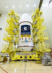
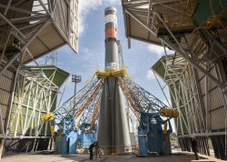
    Galileo First Fixers

    The European Space Agency (ESA)  handed out certificates to the first 50 global citizens to determine their position using only the Galileo system. They got responses from around the world.

    While half the applications for certificates came from Galileo’s home continent, Europe, others first-fixers came from Australia to Canada, Egypt to Vietnam.

    The first positioning fix using only Europe’s civil-owned navigation system took place at ESA’s Navigation Laboratory in Noordwijk, the Netherlands, on March 12,2013.

    The Galileo team knew of fixes being performed on an informal basis, so to mark the anniversary of the first positioning fix they decided to issue commemorative certificates to groups who had picked up the signals to perform their own fixes. Teams were asked to include details of the receiver they used, the start and finish of the fixes in Universal Time Coordinated (UTC), and a plot of their latitude/longitude positioning overlaid on a map.

    Italy turned out to be the single best represented country in Europe, with six separate fixes, followed closely by Germany and the UK with five  each. Several groups had achieved fixes on the same day as ESA in 2013.

    Most of the employed receivers were software-based radio systems, with signal processing performed by software on a computer linked to a radio-frequency front end. Professional receivers were also customised for the job.

    “Most of the applications were obtained with static receivers and simple position fixes with Galileo’s Open Service signals,” explains Galileo engineer Gaetano Galluzzo.

    Belgium’s Royal Military Academy performed Galileo’s first position fix at sea, aboard Belgian frigate Leopold-I, while sailing along the Norwegian coast.

    A German telecom company made use of the satellite signals for timing and network synchronisation – one of the most important applications of Galileo will be as a nanosecond-scale time source, enabling the effective synching of financial, power and data networks around the globe.

    Finally

    Talking of fixes – has anyone heard anything from Galileo GSAT0104 recently? According to the European GNSS Service Centre, the fourth IOV satellite is “unavailable until further notice.” The setting of unavailability may be due to in-orbit validation testing, as the website implies may be the case, but no further official statement has appeared, nor active user notifications (NAGUs) at http://www.gsc-europa.eu/system-status/user-notifications.

    There have been a number of NAGUs over the past couple of months concerning outages and, at different times, one or more of the Galileo satellites have been off line while this extended period of testing takes place.

    A bientôt, as they say in these parts.

  • Occupy Media Space Now EGNOS and Galileo Mission

    By Peter de Selding

    The message to the recent European Space Solutions conference in Prague was simple enough: EGNOS is here, so let’s use it; Galileo is almost here, so let’s promote it.

    Neither task is straightforward.

    Take the European Geostationary Navigation Overlay Service (EGNOS), the European piece of a near-global network of terminals on geostationary satellites linked to networks of ground stations to verify GPS signal accuracy, primarily for aviation but with further applications as well. Other pieces of this global network are the Wide Area Augmentation System (WAAS) in the United States, the System for Differential Corrections and Monitoring (SDCM) in Russia,  GPS-aided GEO-augmented Navigation (GAGAN) in India, and Multi-functional Satellite Augmentation System (MSAS) in Japan.

    EGNOS is operational. It works. Once airports publish the required specificafions for localizer performance with vertical guidance (LPVs), aircraft with EGNOS terminals ultimately will be able to use EGNOS for flight terminations up to as low as 200 feet above the runway. Gone is the need for runway infrastructure, and welcome to the long-promised world of satellite-based augmentation systems. “It offers cheap solutions for precision approach,” said Fabio Gamba, chief executive of the European Business Aviation Association.

    In the United States, where business aviation is a bigger market than in Europe, some 3,400 LPVs have been published for 1,670 airports. In Europe, the equivalent figure is 108 LPVs at 77 airports.

    Why the sluggish response? Gamba cited a long list of issues, including some that appeared more political than technical. Part of the reason, some said, was that the EGNOS backers, including the company under contract to manage the system — European Satellite Services Provider (ESSP) of Toulouse, France — have not done enough to get the word out.

    After all, these observers said, EGNOS suffered multiple delays, and its bigger younger brother, Galileo, has had bad press for years as its business model, ownership, regulatory backing, and schedule took turns in making eyes roll in Europe.

    But that’s yesterday’s issue. Thierry Racaud, chief executive of ESSP, said EGNOS posted greater than 99 percent availability in May for its safety-of-life service, which is currently available on none of the other regional GPS augmentation systems except WAAS.

    Racaud promised that the 108 LPVs signed so far would grow to 180 by the end of this year, and that 200-foot level approaches would be certified by late 2015. He said he hoped all 28 member nations of the European Union would have concluded their EGNOS regulatory approvals by 2017 or 2018.

    “What we need now is more users,” Racaud said.

    If EGNOS is not well known on its home turf, imagine its status in Africa, where European companies are trying to sell its adoption. Abdel Nasser Saint’Anna, director of the EGNOS-Africa Joint Program Office, said Africa should be Exhibit A for an EGNOS success pitch. Of the 2,500 runways in Africa, he said, only 177 were equipped with instrument landing systems (ILS), the system EGNOS and Galileo ultimately would like to replace.

    Galileo, with Four, in Fourth

    Galileo, too, appears headed for a successful adoption in many areas around the world even if, once operational, it likely will be the fourth global GNSS system in place, after GPS, Russia’s GLONASS and China’s BeiDou — not counting the large regional Indian and Japanese systems now being developed.

    For those with scorecards, recall that four Galileo satellites, designed to validate the system’s performance, are in orbit. Carlos des Dorides, director of the European GNSS Agency (GSA) in Prague, said tests in May proved Galileo’s interoperability with GPS.

    More importantly, des Dorides said the tests demonstrated how much better it is for consumers when their terminals access GPS and Galileo together. That should be obvious. Less obvious: Results were much better than with terminals tracking both GPS and GLONASS, he said.

    The more satellites, the better? Yes, at least up to a point. Whether terminal manufacturers will see fit to incorporate all four global GNSS constellations, plus one or two of the regionals, in their hardware remains to be seen.

    But the pent-up demand for Galileo does now seem better than it was as little as a year ago, despite the fact that some Asian nations attending the conference said they need Galileo to demonstrate its vitality sooner rather than later. Some officials said signal-quality issues with Beidou, and the recent GLONASS outage, will more than make up for Galileo’s delays as long as deployment progress is visible.

    The fact remains that by 2020 there will be more than 100 GNSS satellites in medium-Earth orbit, in addition to the augmentation terminals on geostationary satellites.

    A graphic presented by SpaceTec Partners’ Rainer Horn, whose company has been charged with preparing the Asian market for Galileo, showed just how dense the Asian skies will be with GNSS assets at the end of the decade. India, China, Japan, Taiwan, and South Korea are SpaceTec’s current Asian targets.

    The message from these markets: Launch Galileo now. Drum up support. Occupy the media space.

    Did the European Commission get the message? Time will tell. The next opportunity to wave the Galileo flag comes in late August, when the first two of 22 full-operational-capability satelllites will be launched from Europe’s spaceport in South America. Two more are scheduled to follow late this year.

    Eight satellites in orbit by Christmas will not make an operational service, whatever the brochures say. But does that matter? Galileo now has secure funding, through 2020, for most — not all — of what it needs to launch a full constellation. Absent a new issue, by 2017 few will remember the delays.

    Paul Weissenberg of the European Commission, who has seen the Galileo wars up close, reminded the European Space Solutions audience in Prague that one future Galileo customer sits outside the commission’s offices, waiting for approval to use Galileo’s PRS encrypted service. The U.S. Defense Department’s desire for Galileo does not have an expiration date. Just launch it.

  • The System: GLONASS in April, What Went Wrong

    The System: GLONASS in April, What Went Wrong

    By Gerhard Beutler, Rolf Dach, Urs Hugentobler, Oliver Montenbruck, Georg Weber, and Elmar Brockmann

    What Happened: On April 1, 2014, at 21:15 UTC, all GLONASS satellites started to transmit wrong Broadcast Messages (BM) as previously reported by GPS World. The satellite positions derived from these BM were wrong by up to ± 200 kilometers in each of the three coordinates x, y, and z of the Earth-fixed, geocentric, equatorial coordinate system. The problem disappeared after an hour (after two erroneous BM) for two GLONASS satellites; for other satellites, the problem lasted much longer: up to 10 hours. By about 07:30 UTC on April 2, the April Fools’  “joke” was over.

    Effect on GPS/GLONASS Receivers

    Essentially, we can distinguish two classes of receivers: those using the GLONASS BM for tracking and those not using them. The first class of receivers “became aware” of problems in real time, because GPS and GLONASS observations did not result in a consistent position estimation. In the best case, all affected GLONASS observations were flagged (and removed from further consideration) and the positioning worked properly with a reduced number of satellites. In the worst case, the receivers stopped tracking GPS and GLONASS satellites completely. The second class of receivers tracked GPS and GLONASS normally. The tracking problems created a major uproar in the user community of combined GPS and GLONASS receivers.

    On June 3, 2014, at the 13th meeting of the U.S. National Space-based Positioning, Navigation, and Timing (PNT) Advisory Board, Gerhard Beutler, representing the authors of this article, delivered a presentation including an example of a permanent network of GPS and GLONASS dual-system receivers in Switzerland and neighboring countries, where about 40 percent of the approximately 60 receivers stopped tracking both GLONASS and GPS satellites. The malfunctioning receivers had to be reset manually on the morning of April 2 (for more information, see: www.gps.gov/governance/advisory/meetings/2014-06/beutler1.pdf).

    Event as Viewed by the IGS

    At first sight, the GLONASS April 1 and 2 event was actually a non-event for the International GNSS Service (IGS). The IGS is a voluntary federation of more than 200 worldwide agencies that pool resources and data from about 400 permanent GPS and GLONASS stations to generate precise GPS and GLONASS products.

    The IGS product series, including precise GPS and GLONASS ephemerides, were generated as usual before, during, and after the event.  On April 4, a quick analysis by Urs Hugentobler revealed that only the GLONASS BM were affected; the GLONASS code (pseudorange) and phase observations and the GLONASS satellite clock corrections, were not affected.

    Figure 1 shows that the GLONASS event started simultaneously for all satellites (for stationary receivers, the first wrong positions were calculated for 21:00 UTC, based on the BM with Time of Clock (ToC) at 21:15 UTC). The problem was fixed for the first two satellites (the GLONASS satellites in orbital slots 6 and 23) one hour later; the last satellite wasn’t fixed until 07:30 on April 2 (using the correct BM at 07:45).

    Figure 1. Affected broadcast messages for each GLONASS satellite. Colors indicate the different orbit planes.
    Figure 1. Affected broadcast messages for each GLONASS satellite. Colors indicate the different orbit planes.

    More than 60 percent of the more than 200 combined GPS and GLONASS receivers in the IGS network tracked the GLONASS satellites normally. Fewer than 40 percent of the combined-constellation receivers had serious data outages (for GLONASS or even for both GLONASS and GPS). The number of GLONASS observations used in the daily work of the IGS analysis centers (ACs) was, however, only reduced by about 10 percent on April 2 (and even to a lesser extent on April 1). The small reduction is explained by the fact that only the last three and the first seven hours of April 1 and 2, respectively, were affected.

    As the IGS ACs do not need the BM (neither for GPS nor for GLONASS), but may rather use their predicted orbits derived from the precise ephemerides of the preceding days, the number of good observations was still amply sufficient to calculate precise GLONASS orbits for April 1 and 2, essentially at the expected accuracy level.

    Detailed Analysis

    To further explore the structure of the problem, the BM-derived satellite positions were used as pseudo-observations in an orbit determination process. Orbit determination was successful when analyzing only “good” positions (prior to April 1, 21:00 or after April 2, 07:30). Orbit determination was successful, as well, when using only positions from “bad” BM. Successful means that the root-mean-square (RMS) error of the orbit determination process was of the order of about 0.5 meters per satellite coordinate — the expected order of magnitude.

    As the bad satellite positions are now known to obey the laws of orbital motion, one may further investigate the nature of the differences between the “good” and the “bad” orbital positions. For that purpose, the precise GLONASS orbits of the IGS Center for Orbit Determination in Europe Analysis Center served as a reference. Its orbital positions were compared in the inertial coordinate system (one not rotating with the Earth) to the erroneous BM-derived positions by means of an orthogonal transformation, where only the three rotation angles around the x-, y-, and z-axes of the inertial equatorial coordinate system were estimated.

    Table 1 shows that the positions derived from the normal (“good”) GLONASS BM compare very well to the IGS precise orbits. Except for a minor rotation about the z-axis, one obtains zero-rotations about the orthogonal axes in the inertial coordinate system.

    Table 1. Rotation of the entire system of good orbit positions (April 1, 0:00 – 20:45 UTC) with respect to precise IGS reference orbits (“good” BM) and rotation of the entire system of bad orbit positions (April 1, 21:00 – April 2, 07:00 UTC) with respect to precise IGS reference orbits (“bad” BM).
    Table 1. Rotation of the entire system of good orbit positions (April 1, 0:00 – 20:45 UTC) with respect to precise IGS reference orbits (“good” BM) and rotation of the entire system of bad orbit positions (April 1, 21:00 – April 2, 07:00 UTC) with respect to precise IGS reference orbits (“bad” BM).

    Table 1 also shows that the “bad” positions were obtained from the reference positions by a rotation of about 0.5 degrees around the inertial x-axis. The RMS of 71 meters should be compared to the entire effect of up to 200 kilometers per coordinate. Comparing this RMS of 71 meters with the RMS of the orbit determination of about 0.5 meters per coordinate also says, however, that the “true” transformation is more complicated than one represented by just a series of three rotations.

    We did not further investigate how this more or less consistent rotation could enter into the GLONASS BM. It seems to be clear, however, that a systematic error slipped into the realization of the GLONASS BM, which were activated at a common reference epoch for all satellites (but uploaded to individual satellites at different times).

    Figure 1 suggests that the problem was almost immediately recognized by GLONASS operators: already an hour later the first two satellites started to transmit BM with the usual accuracy level.

    Figure 1 also supports the idea that the problem was remedied satellite-by-satellite. A back-of-the envelope calculation revealed that the satellites were above the horizon of at least one of the Russian uplink sites at the times of switching back to the correct BM.

    Summary and Conclusions

    The GLONASS event was one that we might have described by the phrase “such a thing can never happen.” For the user community, the situation was aggravated by the fact that the event was not reported through the official Russian channel by issuing a Notice Advisory to GLONASS Users (NAGU). This definitely should have happened in the interest of transparency.

    The above analysis was based on information available through the IGS. It was performed weeks after the event. It is worth noting, however, that the information needed for the analysis was available in real time. The reference orbit used in the analyses could have been replaced by the IGS predicted orbits generated in the ultra-rapid series.

    In view of the importance of BM for all users and in particular for the users of IGS real-time products, the IGS might consider monitoring the quality of BM for all GNSS.

    Fixing the GLONASS Bug: Report from Moscow

    In a May 23 conversation with journalists, Javad Ashjaee, president of JAVAD GNSS, decried the recent controversy about monitoring stations on both U.S. and Russian soil, saying it was based in misinformation and misinterpretations, inflated by a political crisis. He also supplied a different perspective on the GLONASS signal outage than has been reported in other media outlets.

    “There was speculation in early April that it took GLONASS 11 hours to correct a software bug because it took that long for all the satellites to pass over a control station on Russian soil. This was not the case, I have learned from conversations with their engineers and with the head person responsible for all of this. One engineer made a mistake and uploaded the wrong software. Until they could find it and debug it — and it took them 11 hours to do so — they could not upload correct software to the satellites.

    “The 11-hour outage was not due to a wait for all satellites to pass over ground control stations on Russian soil to receive a fresh upload of data,” continued Ashjaee. “GLONASS has the capability, like GPS, to make updates via inter-satellite communication. The delay was caused by the time it took to find the bug in the erroneous software that had been uploaded and correct it.”

    Ashjaee addressed the monitoring station controversy, saying that Russia had sought GLONASS monitoring stations in the United States, not for uploading any data, but for monitoring GLONASS satellites to provide more accurate orbit and clock information, for the free benefit of all users.

    Click here for Ashjaee’s full discussion of the U.S.–Russian monitoring station controversy. For news updates on the situation, see http://stage.globalpositioningnews.com/tag/russian-monitoring-stations/.

    Russian Launch

    A single GLONASS-M satellite was launched from the Plesetsk Cosmodrome on June 14. GLONASS-M 55 (with designation 755 once operational and also known as Kosmos 2500), was inserted into the constellation’s Plane 3 and will occupy orbital slot 21.

    Manufacturer Reshetnev reported that the satellite is equipped with an experimental payload capable of transmitting signals in the L3 frequency band. The L3 signal, centered at 1202.025 MHz , is CDMA unlike the GLONASS legacy FDMA signals. The experiment will include flight testing of the new equipment and evaluation of its accuracy characteristics. The GLONASS-K1 test satellite also transmits an L3 signal.

    GLONASS-launch-O

    European Space Symposium: Digest

    Copernicus, “the younger brother of Galileo,” will be the main implementation of Galileo and other GNSS technologies going forward in Europe, according to to Paul Weissenberg, EC deputy director general for enterprise and industry. An Earth-observation satellite program administered by the European Space Agency to provide accurate and timely information to improve the management of the environment, understand and mitigate the effects of climate change, and ensure civil security, Copernicus was previously known as the Global Monitoring for Environment and Security (GMES).

    Sliding to the Right. Galileo will make its “early-service declaration in the first half of next year,” said Matthias Patschke, director of EU satnav programs. This appears to back off slightly from previous dogged determination to declare services before the end of 2014.

    The EC may propose legislation to make mandatory the use of GNSS technology in different areas: as with eCall, starting in 2015, including Galileo in the receivers inside cars, according to Marian-Jean Marinescu, member of the European Parliament.

    Peter Large of Trimble spoke out against the mandating of a specific GNSS use in any market: “A bad policy outcome that moves backward into regionalization.”

    For an expanded report, see the June GNSS Design & Test e-newsletter.

  • EuroGeographics to Create Expert Group in GNSS Positioning

    Members of EuroGeographics are creating a European platform for networking, sharing best practices, and exchanging expertise on GNSS positioning.

    Plans for the new Positioning Knowledge Exchange Network (KEN) were revealed at the association’s recent Extraordinary General Assembly following a proposal by the Head Office for Geodesy and Cartography, Poland. Its focus will include:

    • maintaining a network of experts in satellite positioning and navigation
    • following the development of relevant technologies and practices
    • working on the most effective utilization of Galileo services, and
    • developing common standards, policies and guidelines for best practice.

    Now EuroGeographics members will work to agree on roles and joint actions through a cooperation agreement with the European Position Determination System (EUPOS), the Reference Frame Sub Committee for Europe (Euref), and the Council of European Geodetic Surveyors (CLGE). The new Positioning KEN will incorporate experts from all four organizations and will also invite other key players to participate.

    “This is a really exciting addition to our range of benefits for members,” said EuroGeographics Executive Director and Secretary General Dave Lovell OBE. “It demonstrates how they are driving the association’s development to ensure its activities continue to meet their needs by reflecting emerging trends and the relevant interests of the European Institutions. We look forward to strengthening our relationships with EUPOS, Euref and CLGE as we work together to create the uniform GNSS service for Europe.”

    EuroGeographics KENs provide an open forum for members and invited experts. Each focuses on an area of particular interest for national mapping, land registry and cadastral authorities. These include Business Interoperability, Quality and Emergency Mapping.