Space News is reporting that the U.S. government has alerted the European Union that any preferential treatment the EU gives to its Galileo positioning, navigation and timing network will likely violate World Trade Organization (WTO) agreements signed by the United States and the 28-nation EU.
According to a report by Peter B. de Selding, U.S. government officials voiced concerns that the EU is weighing equipment mandates for aviation, car-accident reporting and emergency-call regulations that could unfairly tip the scales in favor of Galileo to the detriment of U.S. GPS-enabled hardware.
In a presentation to the 9th Meeting of the International Committee on GNSS, held Nov. 10-14 in Prague, a senior GPS official said the United States and the EU have signed a wide body of satellite navigation agreements designed to promote open market access and interoperability.
European Commission officials have said in recent months that they are still weighing how to stimulate Galileo use.
A hail suppression project dubbed RO-BERTA by the University of Applied Sciences, Rosenheim (Germany), has been selected the winner of the European Satellite Navigation Competition’s (ESNC) University Challenge. Judged by an international expert jury, the University Challenge is a special prize to reward innovative ideas emerging from Europe’s universities.
The Hail Navigator system is designed to reduce damage caused by hail. Based on the premise of suppressing the formation of hail by injecting silver iodide into clouds, Hail Navigator combines navigation with a precipitation reporting system that can guide pilots to optimal locations for hail suppression missions.
The system is complemented by weather observations (including precise times and locations) reported by local citizens via a smartphone app, which aids the validation of weather prediction models. These models constitute an important factor in deciding whether a hail suppression flight is necessary.
The project team was awarded the prize on October 23 in Berlin at the ESNC Awards Ceremony. More than 300 guests attended, representing the top European players in the navigation sector. In addition to cash, the prize includes support through the GNSS Research & Applications Centre of Excellence (GRACE) and a free ticket to the Munich Satellite Navigation Summit 2015.
“Winning this prize once again demonstrates that interdisciplinary cooperation is feasible and successful,” said Project Manager Peter Zentgraf. “The positive feedback the competition provides helps drive our many students to continue their dedicated work, which made it possible to reach our project goals.”
Matters sit not well with Galileo, the European GNSS. Only one of six currently orbiting satellites can be said to be truly and fully operational. With these troubles augmented by persistent uncertainties regarding the fitness of Soyuz rockets, despite a recent inquiry panel that identified a root cause of the August launch failure, the European Commission has nixed an upcoming December launch. The European Space Agency will have to wait until February 2015 to see if the skies clear by then for the next opportunity to place two new satellites into orbit.
Hard-charging veteran investigative reporter Richard Langley has learned from his eastern listening post in New Brunswick that “E11 and E12 [launched three years ago] exhibit ongoing problems with the onboard clocks. E20 [launched two years ago] has experienced power-supply problems and, following a brief outage, is now broadcasting on E1 only and with a reduced power. The latest two satellites [rose August 22 of this year] are in irregular orbits and will likely not form part of the final constellation. This leaves E19 [born October 12, 2012] as the only fully operational satellite operating within specifications.
“So, strictly speaking, only one of the currently orbiting satellites is fully operational. However, for most (E1/L1-only, single-point) users, four of the six satellites are currently quite useable. Moreover, preliminary studies suggest that, once on line, the latest two satellites will be perfectly usable, despite the irregular orbits. And, as we have heard, there will be attempts to make the orbits somewhat more circular.”
Langley cites “knowledgeable researchers” as his sources.
The initial quartet of in-orbit validation (IOV) satellites — E11, E12, E19, and E20 — constructed by Astrium GmbH and Thales Alenia Space have experienced a range of difficulties outlined above. The decision to cancel the next scheduled launch in December of the newest duo of full operational capability (FOC) satellites, manufactured by a consortium led by OHB AG, comes on the heels of a completed inquiry that blamed a “design ambiguity” of the Soyuz rocket’s Fregat stage for the too-low orbits of Satellites 5 and 6, but left several lingering doubts about other Soyuz issues that were uncovered and must be corrected.
The situation is complicated by further unresolved issues aboard the two FOC satellites themselves. They each failed to deploy one of their two solar arrays on the first try. After several days of effort and re-orientation of the satellites by ground controllers, the arrays were successfully unfolded, but the cause of the initial failure remains unknown. “There is no conclusion on a root cause,” stated one official. “Was it a consequence of the bad orbit, or is there an issue with the solar array deployment mechanism? We cannot yet say for sure.”
As for their incorrect orbit, getting them into their originally planned paths around the Earth is impossible. They simply do not have enough fuel onboard. ESA does, however, plan to raise the perigees of the satellites to get them out of the Van Allen radiation belt, which could severely damage the satellites. The agency also envisions reducing the maximum Doppler frequency shift from 9.6 kHz to at least 6.8 kHz to allow receivers to easily acquire and track the satellites but leave enough hydrazine for future station-keeping. Spokespersons hold out hope that the satellites may yet be usable somehow, someday, after some adjustment measures are taken: a rephasing, a special almanac, perhaps other adjustments.
Overall, a disheartening picture, with some pessimists concluding that “2013 and 2014 have been lost.” The recent slip of full operational capability declaration from 2018 to 2020 may have to be revised yet again. However, lessons learned, etcetera. Galileo has had its ups and down. Advocates may draw comfort from the wisdom imparted by 19th-century German philosopher Friedrich Wilhelm Nietzsche, “Was mich nicht umbringt, macht mich stärker.” That which does not destroy me, makes me stronger.
As European satellites offer a possibility to improve the efficiency of train control systems, GNSS technology is starting to gain momentum in the rail sector. To promote the role of GNSS in this important sector, the European GNSS Agency (GSA) recently exhibited at Innotrans — a leading rail transport tradeshow.
EGNOS can and, in the future, Galileo will provide continuous and highly reliable positioning service — helping increase the competitiveness of rail among other modes of transportation. Currently, GNSS in European rail is primarily used within non-safety-of-life applications, including asset management and passenger information services. However, the latest technological developments show that augmented GNSS, together with specific sensors, can help satisfy the stringent CENELEC Safety and Integrity Level requirements.
As a result, the rail sector has an increasing demand for cost-effective and innovative GNSS applications for both safety critical and non-safety critical purpose. For example, in the safety-critical domain, GNSS-based applications can provide signaling and autonomous train control. In the non-safety critical domain, GNSS is helping improve the performance of asset management and passenger information systems.
Showcasing the E-GNSS Advantage
With rail becoming an important market segment for GNSS technology, and to put emphasis on the many benefits E-GNSS can bring the rail sector, for the first time the GSA exhibited at a rail tradeshow. At Innotrans, one of the leading international tradeshows for the sector held September 23-26 in Berlin, the GSA showcased the EGNOS advantage for rail.
Joining a panel discussion hosted by the European Railways Agency (ERA) entitled “How Heaven Could Support European Train Control System (ETCS),” GSA Head of Market Development Gian-Gherardo Calini explained how European GNSS can serve as a solution to some of the problems the sector currently faces.
“Although rail will become a major market for E-GNSS, it is already providing benefits, such as helping to improve safety,” he said. “Our role at the GSA is to serve the end user by making sure the technology delivers the necessary solutions.”
Calini acknowledged there are challenges to the sector’s full adoption of GNSS, but stated that other sectors have overcome challenges and are benefiting from E-GNSS: “It is a successful reality in other transport sectors, especially aviation, and we must focus on building from these experiences,” he said.
The ERTMS/ETCS is a major industrial project that aims to replace Europe’s different national train control and command systems. The deployment of ERTMS will enable the creation of a seamless European railway system with aligned signalling — essential to increasing the competitiveness of European railways.
Europe’s GNSS systems — Galileo and EGNOS — are actively contributing to the needed evolution of the ERTMS. One example of this long-term perspective is the Shift2Rail Joint Undertaking, whose objective is also to support the adoption of GNSS in the rail sector. Within this undertaking, it is foreseen that both Galileo and EGNOS will be brought into ERTMS standards and foster European GNSS adoption in the area of Low Density Lines.
The European GNSS Agency (GSA) and the European Commission have concluded an agreement that delegates a range of exploitation tasks for Galileo to the GSA, providing a framework and budget for the development of services and operations through 2021.
The signing of the Galileo Exploitation Delegation Agreement serves as an initial step towards the full Galileo Exploitation Phase.
According to the governance structure set out in the Agreement for the Galileo programme, the European Commission is responsible for the overall programme supervision, the European Space Agency (ESA) is entrusted with the deployment phase, while the GSA is responsible for the exploitation phase.
As to the exploitation phase, the GSA’s responsibilities include:
Provision and marketing of the services
Management, maintenance, continuous improvement, evolution and protection of the space and ground infrastructure
Research and development of receiver platforms with innovative features in different application domains
Development of future generations of the system
Cooperation with other GNSS
All other required activities to ensure the development and smooth running of the system
“With Galileo, we aim to provide a tangible service to European citizens, and this Delegation Agreement ensures we have the tools and funding necessary to achieve this,” said GSA Executive Director Carlo des Dorides.
The Galileo exploitation phase will be progressively rolled out starting in 2014-2015, with full operability scheduled for 2020.
The agreement was signed between Daniel Calleja Crespo, director-general of the Enterprise and Industry Directorate-General at the European Commission and Carlo des Dorides, executive director of the GSA. The agreement specifically sets the actions to be implemented, the amount of funding provided, and the conditions for the overall management.
The implementation period of the agreement runs until 2021, with a comprehensive review of its functioning by the end of 2016. The maximum current EU contribution amounts to EUR 490 million, which will cover procurement and grant activities, including the GSA-ESA working arrangements and a programme management reserve, along with related research and development activities. The financing of the full exploitation phase will be confirmed during a mid-term review before the end of 2016.
Summer 2014 will be one that the €6.3 billion (US$8.2 billion) Galileo GNSS programme will need to chalk down to experience and hope to move on from. At the time of my last EAGER column, we were starting to get a hint that one of the four in-orbit Galileo IOV satellites was not functioning. We now know that it has suffered a catastrophic power failure.
And in August, celebrations for a successful launch of the first two Galileo FOC satellites, named Doresa and Milena, quickly went sour when it became clear that they had suffered an anomaly during launch. And a very big anomaly at that.
We are still awaiting the preliminary results from the inquiry set up by the European Space Agency (ESA), the European Commission, and the rocket’s operator Arianespace. It is hoped that the results of the inquiry board will be available at the end of September.
ESA spokesperson Franco Bonacina informs me that on the satellite side, ESA’s teams at the ESOC control centre are investigating the possibility of partially raising or modifying the orbit of the two satellites, which are fully under control and in good health. They are also considering performing some software adaptations on board the spacecraft and at ground station level to try and make them “be seen” as operational satellites and able to provide operational services within the Galileo system. All this is still “work in progress” and it will take a few more weeks to be fully evaluated and put into practice.
So, what went wrong?
In the absence of firm conclusions from the inquiry, the rumour mill has been running at full throttle with the wide range of theories from cock-up to conspiracy.
What we do know is that the Galileo craft were supposed to be launched by a Soyuz-Fregat rocket into a circular orbit 23,222 kilometres above the Earth and angled at 56 degrees to the planet’s equator. The initial launch from Kourou, French Guiana, on August 22 seemed to be smooth and nominal, but something went wrong in the final stages of the flight, and the two satellites were placed in an elliptical orbit varying from more than 2,000 kilometres too high to nearly 10,000 kilometres too low and also tilted by about 5 degrees from the intended plane.
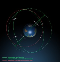
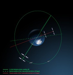
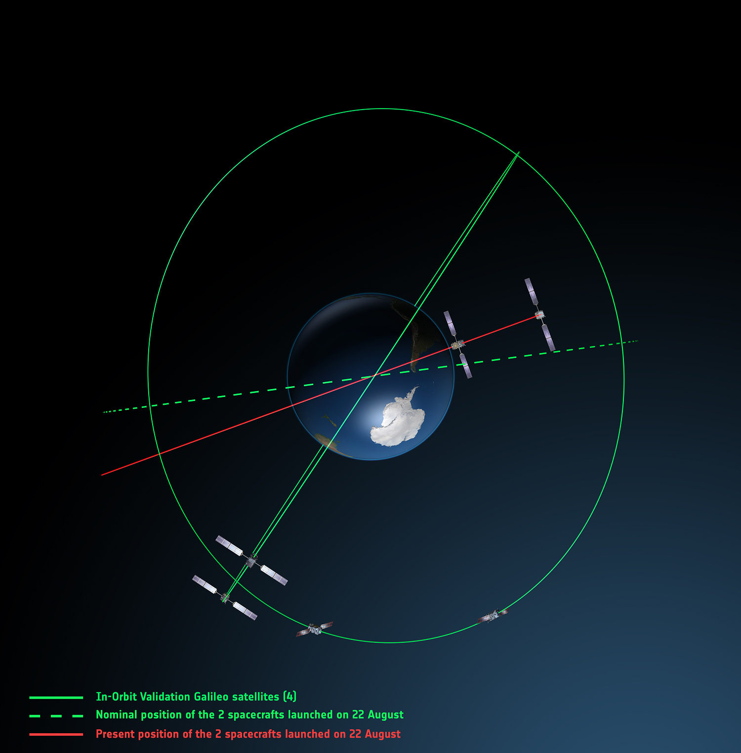
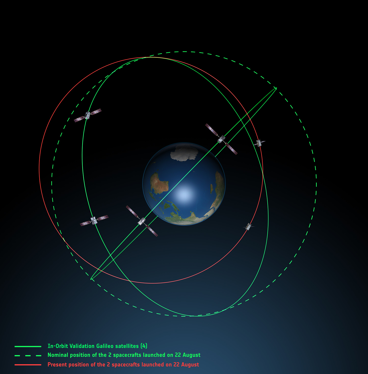
Galileo orbits viewed side-on.
Galileo orbits viewed from above.
The most plausible explanation for the anomaly is that the Soyuz – Fregat upper stage suffered a control malfunction at some point before its final orbital injection burn. So although the rocket engine seems to have fired correctly, the craft wasn’t pointing in the right direction.
In fact, I am told that a likely mechanical root cause for the anomaly in the Fregat stage has been identified by the inquiry committee; however, more information is being gathered and further technical analysis is required to verify this.
Can anything be done?
Doresa and Milena do not have enough fuel on board to achieve the correct orbit for full Galileo operations.
Some interesting solutions have been proposed to launch a rescue mission to drag the errant satellites into their correct orbit, but that could be a slow, risky and expensive exercise. So could the satellites be useful in situ?
For most GNSS uses, the answer is probably no. Despite the fact that the satellites themselves are apparently working perfectly, in a safe state, correctly pointing towards the Sun, properly powered and fully under control of the ESA team, their elliptical orbit does not conform with Galileo’s standardized data format. For example, the value that represents the shape of the satellites’ orbit is too big to be expressed within the allotted bit limit for that parameter.
Marco Falcone, ESA’s Galileo system manager, says his team have been working intensely to determine if the satellites can be at least partially recovered. Among the considerations are the flight dynamics of moving the two spacecraft and the impact of the radiation they are experiencing in their current location, which can shorten the satellite’s lifetime. “It’s very dangerous for the satellite,” admits Falcone.
Another unknown is the timing performance of the satellites’ rubidium frequency and hydrogen maser given the relativistic effects of their orbit. Signal issues, such as the navigation message almanac, also must be considered before the FOC satellites can be introduced into operation, Falcone said.
Good for geoscience?
But according to fellow GPS World contributor Richard Langley of the University of New Brunswick, the situation is more hopeful for scientists wanting to use Galileo-derived data in their research. Quoted in an article in leading science journal Nature, Richard says that researchers tracking GNSS satellites via the IGS global network of ground stations combine that information with the timing data transmitted by the satellites themselves and could use it to measure changes in the position of points on the ground much smaller than the one-metre margin of error for standard navigation-system receivers. This level of precision is good enough to detect millimetres of movement in tectonic plates, for example.
This reminded me of a presentation by a team of Italian scientists I saw recently. The VADASE (Variometric Approach for Displacements Analysis Stand-alone Engine) project uses a novel strategy consisting of an algorithm able to perform real-time retrieval and estimation of displacement and waveforms based on high-frequency (1 Hz or more) carrier phase observations collected by a stand-alone GNSS receiver. The algorithm works with broadcast data (satellite clocks and orbits), requires very simple hardware, and has demonstrated potential application in real-world situations such as earthquake risk assessment (and related early-warning systems for tsunamis) and structural monitoring (see citations below). VADASE had already achieved a Galileo-only displacement solution using the four IOV satellites in orbit.
I contacted Gabriele Colosimo at Rome’s “Sapienza” University, and he confirmed that, although the satellites could not be used for direct gravimetric studies that require a very low orbit (below 1,000 km), the data from Doresa and Milena could be used to estimate displacements of GNSS receivers. He and the VADASE team think that a slight adjustment in their algorithm might be needed depending on the exact orbit parameters of the satellites, but the data would be useable without any significant change in orbit being required.
Gabriele also thinks that the data could be used to usefully contribute to studies in fields such as troposphere studies and GNSS reflectometry, as well as for geodynamic and seismic monitoring using GNSS.
Munich Masters
Hopefully the mystery of Doresa and Milena’s anomaly will have been resolved by October 23, when the 2014 European Satellite Navigation Competition (ESNC) awards ceremony takes place in Berlin in conjunction with the two-day Satellite Masters Conference.
But the real prize for the European GNSS community would be a full explanation of the recent Galileo issues, and how they are being resolved, and a clear statement and timeline on the future deployment and implementation of this flagship programme.
A bientôt – as they say in these parts
Citations
G.Colosimo, M. Crespi and A.Mazzoni, “Real-time GPS Seismology with a stand-alone receiver: A preliminary feasibility demonstration,” Journal of Geophysical Research, vol 116, doi: 10.1029/2010JB007941
M. Branzanti, G.Colosimo, M.Crespi and A.Mazzoni, “GPS near-real-time coseismic displacements for the great Tohoku-oki earthquake,” IEEE Geoscience and Remote Sensing Letters, vol 99, doi: 10.1109/LGRS.2012.2207704
Galileo’s first two full-operational capability (FOC) satellites have been in a safe state since August 28, under control from the European Space Agency’s (ESA’s) center in Darmstadt, Germany, despite having been released on August 22 into lower and elliptical orbits instead of the expected circular orbits.
ESA continues investigating the possible exploitation of the out-of-position satellites to maximum advantage, despite their unplanned injection orbits and within the limited propulsion capabilities. ESA specialists, supported by industry and France’s CNES space agency, are analyzing different scenarios that would yield maximum value for the program, and safeguard — as much as possible — the original mission objectives.
Galileo orbits viewed from above: Orbits of the fifth and sixth satellites in red, compared to their intended position in dashed green, and the position of the four satellites launched in 2011 and 2012 in solid green. This view looks down over the South Pole to illustrate how the inclination relative to the equator is less than intended. The satellites are in an elliptical rather than circular orbit, with a maximum altitude of about 25,900 km and a minimum altitude of about 13,700 km, compared to a planned circular orbit of 23,222 km altitude.
Experts representing the Galileo Program provided a frank and open update at the ION GNSS+ conference in Tampa on September 10, as reported by Richard Langley:
An inquiry board is looking into problem to find the root cause of the anomaly. The board has already met several times.
An intermediate report is due shortly; a final report and recommendations will come next month.
ESA is considering what can be done with the two satellites; ESA hopes to be able to use them operationally as much as possible.
ESA is also looking at the impact on the commercial Galileo service and the search-and-rescue service.
ESA is narrowing down the possible causes of the anomaly.
ESA is waiting for the enquiry board to report before deciding on when and how the next two satellites will be launched.
The payloads of the errant satellites are currently off.
ESA wants to try to raise the perigees of the satellites to get them out of the van Allan radiation belt as soon as possible to prevent damage to the satellites. Raising the perigrees will also to reduce the maximum Doppler frequency shift from 9.6 kHz to at least 6.8 kHz to allow receivers to easily acquire and track the satellites, but leave enough hydrazine for future station keeping.
ESA is looking at the almanac problem and whether unused bits in the Galileo navigation message might be able to support a special almanac for the satellites.
ESA is also looking at possible rephasing of the satellites to optimize their use with the other satellites in the constellation.
Galileo orbits viewed side-on: The fifth and sixth Galileo satellites in red, compared to their intended position in dashed green, and the position of the four satellites launched in 2011 and 2012, in solid green. This view looks side on to the two satellites’ orbital plane, which is off-center relative to Earth. The targeted orbit was circular, inclined at 55º to the equator at an altitude of 23,222 km.They are in a safe state, correctly pointing towards the Sun, properly powered and fully under control of an ESA–CNES team.
Soyuz at Fault? On August 28, the Russian newspaper Izvestia reported that “The failure of the European Union’s Galileo satellites to reach their intended orbital position was likely caused by software errors in the Fregat-MT rocket’s upper stage.”
“The nonstandard operation of the integrated management system was likely caused by an error in the embedded software. As a result, the upper stage received an incorrect flight assignment, and, operating in full accordance with the embedded software, it has delivered the units to the wrong destination,” an unnamed source from Russian space Agency Roscosmos was quoted as saying by the newspaper.
An independent inquiry panel has been set up by Ariane and headed by former ESA Inspector General Peter Dubock. It started work on August 28. The panel includes a couple of academics and a majority of ESA and EC figures.
The new EC commissioner in this area, Ferdinando Nelli Feroci, invited ESA and Arianespace to his study during the first week of September to present the initial results of the inquiry.
The commissioner commented, “The problem with the launch of the two Galileo satellites is very unfortunate. The European Commission will participate in an inquiry with ESA to understand the causes of the incident and to verify the extent to which the two satellites could be used for the Galileo programme. I remain convinced of the strategic importance of Galileo, and I am confident that the deployment of the constellation of satellites will continue as planned.”
The commissioner expects that the Galileo constellation will be fully deployed by the end of this decade. This may qualify as optimism because system planners had envisioned for six spares — and three are already blown.
Ariane and ESA did not insure the satellites.
According to back-of-the-envelope calculations, system operators are now one short of the minimum 24 needed for full 24/7 global coverage, as they have four in orbit validation satellites up (one broken) and 22 FOCs on order (two launched and now in what could be called a junk orbit), which makes a potential maximum 23 satellites that have actually been ordered — one short of the target.
The Satellites Are Alright. Satellite manufacturer OHB Systems of Bremen, Germany, issued a release stating that “Controllers at ESA’s ESOC control centre in Darmstadt, Germany, confirm the good health and the nominal behavior of both satellites. They are in a safe configuration, are thermally stable, have stable pointing to the sun and sufficient power production. All platform subsystems have been checked and they work properly. Also, the procedures to deploy the solar arrays are successfully performed and all solar arrays are properly unfolded.”
Further, “The orbit anomaly has no impact on the production and delivery of the in total further 20 satellites. Two FOC satellites are currently at ESTEC test facilities in Noordwijk, the remaining are in various status of integration. ”
Blogs Alive; BBQ Mode. The chairman of the Executive Board of the German Aerospace Center, Johann-Dietrich ‘Jan’ Wörner, writes an interesting blog. A recent installment opened with a quote from Elon Musk: “Rockets are tricky.”
Wörner went on to say, “The Soyuz launcher lifted off from the European Spaceport in French Guiana. Initially, all of the measurements suggested a perfect mission; the launcher took off at the scheduled time, followed the prescribed trajectory, and the stage separation was carried out correctly. However, the first problem became apparent when the two satellites proved unable to deploy their solar arrays as intended. A more detailed analysis then revealed that the eccentricity, the altitude and the inclination of the satellites’ orbits with respect to Earth’s equator did not meet the specifications. The upper stage had also evidently failed to induce the planned rotation around the longitudinal axis of the spacecraft (known as ‘barbeque’ mode, designed to maintain favourable thermal conditions during exposure to the Sun).”
Further discussion of the possible causes of the anomaly can be found on a Russian site, which focuses on the Fregat stage thrusters and indicates that the Russians think the barbeque maneuver was completed, and thus not the problem.
The other big issue is how the telemetry didn’t pick up the issue straight away.
Rockwell Collins has successfully received and tracked a Galileo satellite signal using a prototype GNSS receiver designed for secure military use.
In 2013, Rockwell Collins received a $2 million contract from the Air Force Research Laboratory (AFRL) and the GPS Directorate to develop and demonstrate a Secure Software Defined Radio (S-SDR) GNSS receiver capability. By using multiple available satellite signals, improved and more robust signal availability can be obtained, enabling a compatible GNSS receiver to deliver superior position determination that can improve navigation performance and signal availability.
Hosted in a software-defined radio, the S-SDR program will develop the security architecture required for receiver equipment approvals and certifications. The arrival of modernized GPS signals and other global constellations is changing the way the U.S. military and its allies accomplish secure GNSS-based positioning, navigation and timing. The European Galileo constellation coming on line during 2015, including its open signals and secure Public Regulated Service, is expected to provide an opportunity for improved robustness in satellite based navigation, in both commercial and government applications.
“This milestone reinforces our belief that Rockwell Collins is uniquely positioned to produce a navigation receiver that will meet global needs,” said John Borghese, vice president of the Advanced Technology Center for Rockwell Collins. “With decades of experience developing GPS systems and leading edge security architectures, our company continues to be a top innovator in this field.”
More than 35 years ago, Rockwell Collins assisted the U.S. Air Force in developing GPS technology. That legacy continued when the company created the world’s first all-digital miniature GPS receiver under contract with DARPA. Over the years, Rockwell Collins has produced more than 50 GPS products and delivered more than 1 million GPS receivers for commercial avionics and government applications. The GNSS receiver technology being provided for the S-SDR program will continue this legacy of providing leading edge GNSS solutions.
In the presence of the European Commission, the European GNSS Agency (GSA) and EuroControl have signed a new cooperation agreement to jointly contribute to the implementation of European Union GNSS policies as they apply to the field of aviation.
As Europe’s skies and major airports become increasingly congested, there is need for Air Traffic Management (ATM) technologies to evolve from ground-based infrastructures to more advanced systems based on new technologies. EuroControl and the GSA have a shared objective in developing and exploiting European GNSS technology to improve accessibility, efficiency and safety to European operators, pilots and airports.
To accomplish this objective, the agreement focuses on a range of activities, including:
Definition of aviation user requirements for EGNOS and Galileo
Introduction of European GNSS services for aviation within the European Civil Aviation Conference (ECAC) area
Coordination in aviation research and development
Aviation-specific GNSS performance monitoring
Promotion of European GNSS aviation activities at the international level
“This is another example of European Commission support of the aviation sector,” said Daniel Calleja Crespo, director general of DG Enterprise and Industry at the European Commission. “I am confident that a strong cooperation between the GSA and EuroControl will benefit aviation, the European GNSS Programs and indeed European citizens.”
“The full deployment of GNSS offers unprecedented opportunities to further improve air traffic management safety and capacity, while reducing costs at pan-European level,” said GSA Executive Director Carlo des Dorides. “EuroControl’s activities in this field will complement those of the GSA to ensure that the development and implementation of satellite-based navigation provides an optimal solution for European airspace users.”
“EuroControl and the GSA share a common objective — the secure and safe implementation of European satellite navigation policies in the aviation sector. The enhanced cooperation between our two organizations means that EuroControl will now bring its unequaled capacity to understand, coordinate and represent the needs of the civil and military airspace users to the promotion and development of GNSS,” said Frank Brenner, director general of EuroControl.
EGNOS is Europe’s first venture into satellite navigation and has been providing a certified safety service for aviation users since 2010. EGNOS is owned by the European Union and, since January 1, 2014, the GSA is responsible for its exploitation, ensuring service provision, operations, maintenance and evolution.
The year 2014 is most certainly the Year of Galileo.
After rising up from near elimination in 2008 due to much confusion about how to fund it, the European Union, that same year, decided to allocate 3.4 billion euros to fund the ground infrastructure and the initial satellites. Unlike the U.S. GPS and Russian GLONASS systems, Galileo is civilian-funded as opposed to being funded primarily from defense budgets, which makes it politically much more difficult to gain funding. But, they did it.
That was six years ago.
Since then, ground infrastructure has been designed and built. Six test satellites have been designed, built and successfully launched into orbit. In early 2013, the first position fix using only Galileo satellites was achieved. With all the necessary test satellites launched and systems tested, the anticipation of FOC (Full Operational Capability) satellite launches has been high, because it would signal the rapid deployment of the Galileo navigation system that would so complement GPS and so benefit the high-precision GNSS user community.
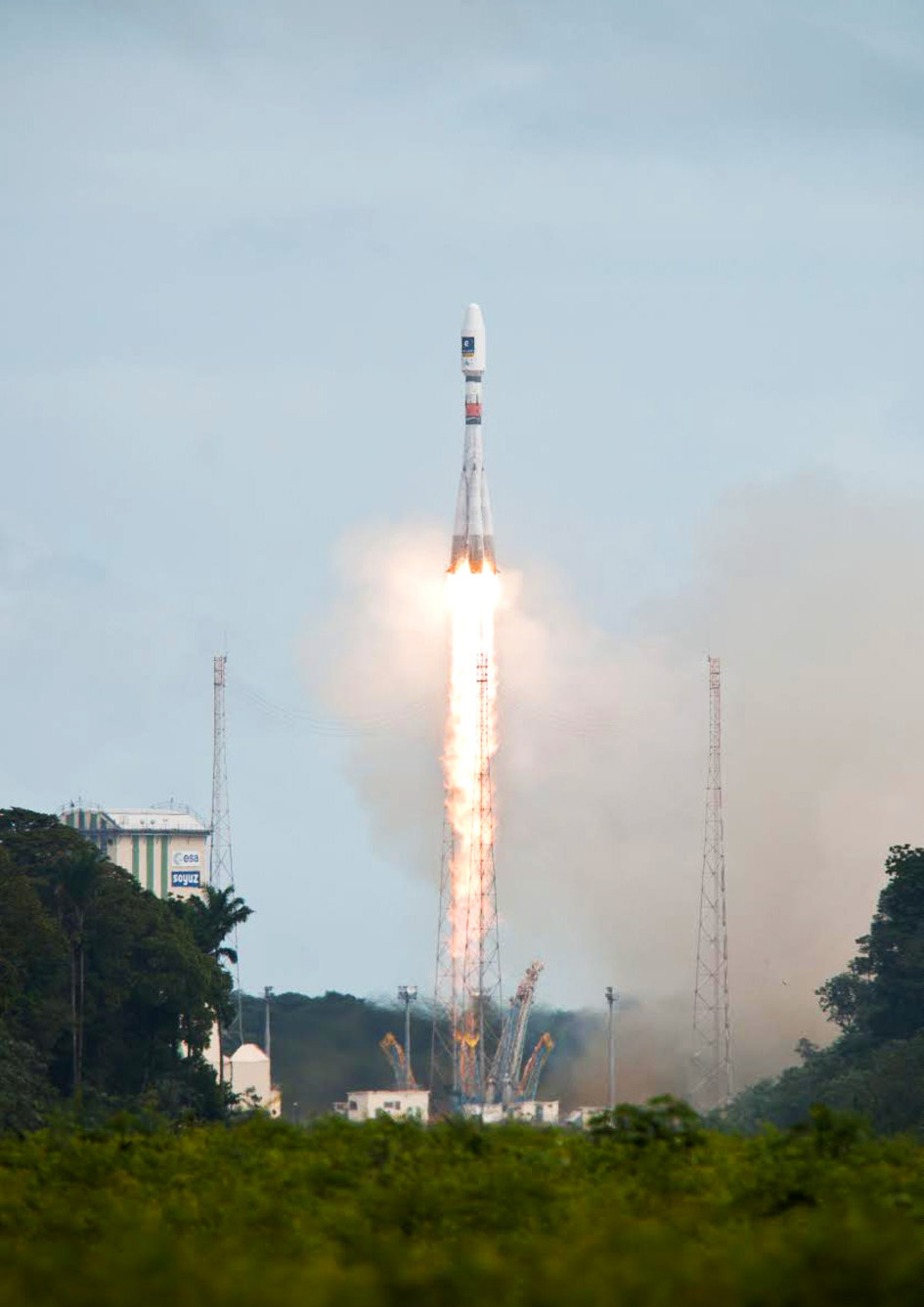
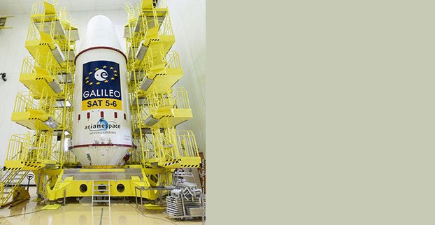
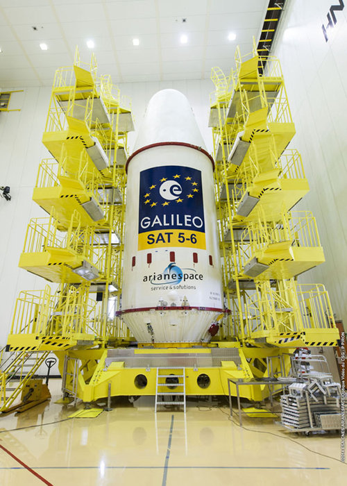
Soyuz Flight VS09, carrying Europe’s fifth and sixth Galileo satellites, lifts off from Europe’s Spaceport in Kourou, French Guiana.
That moment arrived last month, on August 22, with the launch of the first two Galileo FOC satellites. The significance of the first FOC launch is that it would trigger an aggressive launch schedule comprised of one launch every three months, at two satellites per launch — equaling eight satellites launched per year. With four test satellites already in orbit being converted to operational satellites, one can envision 16 Galileo satellites in orbit by the end of next year. While not a complete constellation at that point, it would offer plenty of upside — worldwide I might add, as I’ve written about in the past — by adding more satellites in view and accelerating the adoption of the new L5 signal, which is also supported by GPS.
Between Europe deploying Galileo and China deploying its BDS (BeiDou) system, the world of high-precision GNSS is going to change a lot in the next couple of years. There will be more receiver choices at much lower prices for RTK receivers.
But, the satellite navigation business is not a forgiving one. The devil is in the details, and the number of details has got to be overwhelming. Consequently, there have been many casualties.
The Russians have taken their lumps, losing a total of seven GLONASS satellites to faulty rocket launches in just the past four years.
In 2009, the U.S. placed into orbit a GPS satellite, SVN-49, that never has been set healthy, rendering it a “$100M test satellite.”
Now, the Europeans have joined the club.
The “pucker factor” during the satellite launches is always high, so on August 22, when two Galileo satellites mounted on a Russian Soyuz rocket at the Arianespace launch pad in French Guiana were pushed up into space, there must have been a sigh of relief that the launch seemed to go smoothly. Even I was excited, Tweeting “#Galileo Launch Successful, Satellites Deployed. Booyah!”, shortly after the launch.
However, looks can be deceiving.
It turns out that somehow, some way, the two Galileo satellites, after years of planning, were inserted into the wrong orbits.
The liftoff and first part of the mission proceeded nominally, reports Arianespace, leading to release of the satellites according to the planned timetable, and reception of signals from the satellites. However, the targeted orbit was circular, inclined at 55 degrees with a semi major axis of 29,900 kilometers. The satellites are now in an elliptical orbit, with excentricity of 0.23, a semi major axis of 26,200 km and inclined at 49.8 degrees.
With navigation satellites, we’ve seen disastrous launch failures and defective satellites placed in orbit, but I can’t recall ever hearing about navigation satellites being inserted into the wrong orbits. It’s difficult not wonder how such a seemingly simple error could occur, yet sympathize with the Galileo program managers given the complexity of the task, but also appreciate the consistency and reliability of GPS satellite deployments.
Galileo satellites fastened to upper stage.
The Russians quickly commented on the satellite deployment anomaly since it was a Russian Soyuz rocket launcher, speculating that it was a software bug. The Russian newspaper Izvestia quoted an unnamed source from the Russian Space Agency Roscosmos that “the failure of the European Union’s Galileo satellites to reach their intended orbital position was likely caused by software errors in the Fregat-MT rocket’s upper stage.”
It’s too early to say if the Galileo satellites will ever become serviceable. The Monday following the launch, an independent inquiry commission was formed to “establish the circumstances of the anomaly, to identify the root causes and associated aggravating factors, and make recommendations to correct the identified defect and to allow for a safe return to flight for all Soyuz launches from the Guiana Space Center (CSG).”
This subject will certainly be a hot topic at the Institute of Navigation (ION) GNSS conference being held next week in Tampa, Florida. A full staff of GPS World editors and administration folks will be attending, including yours truly. It’s the premiere GNSS technical event of the year, so I’m sure there will be plenty of scientists and program managers commenting and speculating on the future of these two satellites.
If you’d like the latest news on this and other GNSS-related subjects during the conference next week, follow me on Twitter at https://twitter.com/GPSGIS_Eric. There are lots of interesting subjects at the ION GNSS+ conference. Take a look at the conference agenda here. I’ll be attending many of the presentations related to high-precision GNSS and report to you in next month’s newsletter. To give you a flavor, following are some of the presentations that I’m going to try to attend.
The Triple-frequency Multi-system RTK Engine for Challenging Environments
Mobile Mapping Using Smartphone
Analysis of Using Smartphones for Indoor Mobile Mapping
GPS Program update
Galileo Program Update
Glonass Program update
BDS Program update
GLONASS Only and BeiDou Only RTK Positioning
Comparing Multi-constellation and Multi-frequency Based on GPS/Beidou RTK Positioning
Combined GPS+BDS+Galileo+QZSS for long single-baseline RTK positioning
Real-time PPP with Galileo, Paving the Way to European High Accuracy Positioning
High-Precision GNSS — What will it Look Like in 2020?
“Following the failure on Friday August 22nd to inject Galileo satellites 5 and 6 into the correct orbit, the European Commission has requested Arianespace and the European Space Agency (ESA) to provide full details of the incident, together with a schedule and an action plan to rectify the problem.”
This is the only official face showing, but extremely high levels of activity take place behind the curtain, studying what might have caused several million Euros of hardware to end up much lower above the Earth than desired. Meanwhile, active speculation in the satnav blogosphere provides glimpses of possible outcomes from the latest satellite disaster — not exclusive to Galileo, by any means — created in all likelihood by a malfunction aboard its Soyuz launcher and/or the Fregat upper stage thereof.
The full official EC announcement is available here.
The satellites are under the control of the European Space Operations Centre (ESOC), ESA’s main mission control center in Darmstadt, Germany. But they are far out off position — more than 3,500 kilometers of space away, so far as to make their eventual use as part of the Galileo constellation very unlikely. Discussions continue with ESA and Arianespace regarding whether or not the satellites are likely to be of use, but odds are against it.
Their onboard fuel is not enough to compensate for the launch shortfall to reach higher orbits under their own power. ESA scientists are studying how they might still possibly be used, far from their optimum position,s within the Galileo constellation.
According to an Arianespace press release on August 23, the target orbit was circular, inclined at 55 degrees with a semi-major axis of 29,900 kilometers, but what they got was an elliptical orbit, eccentricity of 0.23, semi-major axis of 26,200 kilometers and inclined at 49.8 degrees.
On August 28, the Russian newspaper Izvestia reported that “The failure of the European Union’s Galileo satellites to reach their intended orbital position was likely caused by software errors in the Fregat-MT rocket’s upper-stage.”
“The nonstandard operation of the integrated management system was likely caused by an error in the embedded software. As a result, the upper stage received an incorrect flight assignment, and, operating in full accordance with the embedded software, it has delivered the units to the wrong destination,” an unnamed source from Russian space Agency Roscosmos was quoted as saying by the newspaper.
An independent inquiry panel has been set up by Ariane. It is headed by former ESA Inspector General Peter Dubock. It starts work on August 28. The panel includes a couple of academics and a majority of ESA and EC figures.
Ferdinando Nelli Feroci, the new EC Commissioner for Industry and Entrepreneurship.
The new EC commissioner in this area, Ferdinando Nelli Feroci has invited ESA and Arianespace to his study during the first week of September to present the initial results of the inquiry.
The commissioner commented, “The problem with the launch of the two Galileo satellites is very unfortunate. The European Commission will participate in an inquiry with ESA to understand the causes of the incident and to verify the extent to which the two satellites could be used for the Galileo programme. I remain convinced of the strategic importance of Galileo and I am confident that the deployment of the constellation of satellites will continue as planned.”
The commissioner expects that the Galileo constellation will be fully deployed by the end of this decade. This may qualify as optimism because system planners had envisioned for six spares – and three are already blown.
Ariane and ESA did not insure the satellites.
According to back-of-the-envelope calculations, system operators are now one short of the minimum 24 needed for full 24/7 global coverage, as they have 4 IOVs up (1 broken) and 22 FOCs on order (2 launched and now in what could be called a junk orbit) which makes a potential maximum 23 sats that have actually been ordered – one short of the target.
The Satellites Are Alright
Satellite manufacturer OHB Systems of Bremen, Germany, issued a release stating that “Controllers at ESA’s ESOC control centre in Darmstadt, Germany, confirm the good health and the nominal behaviour of both satellites. They are in a safe configuration, are thermally stable, have stable pointing to the sun and sufficient power production. All platform subsystems have been checked and they work properly. Also the procedures to deploy the solar arrays are successfully performed and all solar arrays are properly unfolded.”
Further, “The orbit anomaly has no impact on the production and delivery of the in total further 20 satellites. Two FOC*-satellites are currently at ESTEC test facilities in Noordwijk, the remaining are in various status of integration. ”
Blogging the Boondoggle
The chairman of the Executive Board of the German Aerospace Center, Johann-Dietrich ‘Jan’ Wörner, writes an interesting blog. The current installment opens with a quote from Elon Musk: “Rockets are tricky.”
Wörner goes on to say, “The Soyuz launcher lifted off from the European Spaceport in French Guiana. Initially, all of the measurements suggested a perfect mission; the launcher took off at the scheduled time, followed the prescribed trajectory, and the stage separation was carried out correctly. However, the first problem became apparent when the two satellites proved unable to deploy their solar arrays as intended. A more detailed analysis then revealed that the eccentricity, the altitude and the inclination of the satellites’ orbits with respect to Earth’s equator did not meet the specifications. The upper stage had also evidently failed to induce the planned rotation around the longitudinal axis of the spacecraft (known as ‘barbeque’ mode, designed to maintain favourable thermal conditions during exposure to the Sun).”
Further discussion of the possible causes of the anomaly can be found on a Russian site, which focuses on the Fregat stage thrusters and indicates that the Russians think the barbeque maneuver was completed, and thus not the problem.
The other big issue is how the telemetry didn’t pick up the issue straight away.
There is avid speculation and a number of interesting theories being aired on the Canadian Space Geodesy Forum. For subscriptions to this vital listserv, visit here.
Soyuz Flight VS09, carrying Europe’s fifth and sixth Galileo satellites, lifts off from Europe’s Spaceport in Kourou, French Guiana.
Soyuz Flight VS09, carrying Europe’s fifth and sixth Galileo satellites, lifted off from Europe’s Spaceport in Kourou, French Guiana, today (August 22, 12:27:11 UTC/14:27:11 CEST.)
All the stages of the Soyuz vehicle performed as planned, with the Fregat upper stage releasing the satellites into their target orbit close to 23,500 km altitude, 3 hours 47 minutes after liftoff.
These new satellites joined four Galileo satellites already in orbit, launched in October 2011 and October 2012 respectively. This first quartet were In-Orbit Validation (IOV) satellites, serving to demonstrate the Galileo system would function as planned.
Satellites 5 and 6, the first Full Operational Capability (FOC) satellites, are significant as the first of the rest of the Galileo constellation. This launch marks the start of a new phase in the European satellite navigation program where the full constellation will be deployed with short intervals between launches. A steady stream of launches will follow to build the complete Galileo constellation.
Watch a video of the launch here:
On completion of the initial checks, run jointly by the European Space Agency (ESA) and the French space agency CNES, the two satellites will be handed over to the Galileo Control Centre in Oberpfaffenhofen, Germany, and the Galileo in-orbit testing facility in Redu, Belgium, for testing before they are commissioned for operational service in the autumn.
The deployment of the constellation will now move more quickly, with six to eight satellites launched per year using a series of Soyuz and Ariane launches from the CSG, along with finalization of the remaining elements of the ground network.
The final constellation will consist of 24 satellites expected to be ready in 2017 and complemented by six in-orbit spares.
This deployment phase of the Galileo program is being managed and funded by the European Commission, with ESA acting as design and procurement agent on behalf of the Commission.