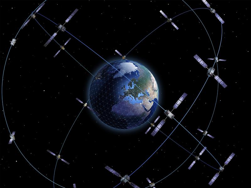
The European Space Agency (ESA), in collaboration with the Joint Research Centre of the European Commission, are hosting this year’s ESA/JRC International Summer School on GNSS with the Swedish Space Agency in July in Kiruna, Sweden. The course will include an overview of satellite navigation from the theoretical basis of GNSS, their signals, and processing by receivers and more.
Elements of this year’s program will include details of low-Earth-orbit positioning, navigation and timing, navigation on the Moon, and Galileo’s Open Service Navigation Message Authentication. Exercises will include receiving signals from Galileo and other GNSS.
Participants will also learn about business aspects, intellectual property rights, and the future of satellite navigation systems, including Galileo second-generation.
Some of the world’s leading satnav and space experts will be giving lectures. Lecturers include Paul Verhoef, former director of navigation for ESA, and Jean-Jacques Dordain, former director general. The course will be opened by Anna Rathsman, Director General of the Swedish National Space Agency; Javier Benedicto, Director of Navigation at the European Space Agency; and Georgios Giannopoulos, head of the Technologies for Space, Security and Connectivity Unit at the Joint Research Centre of the European Commission.
The course is limited to 50 participants on a first-come, first-served basis and is open to graduate students, Ph.D. and postdoctoral researchers, as well as young engineers and academics working within industry or agencies, aged 38 or younger.
The summer school will take place July 17-28 in Kiruna, Sweden. Register before April 14 for a reduced early fee. For more information and to register, click here.
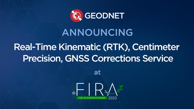
GEODNET has released a real-time kinematic (RTK), centimeter-precision, GNSS corrections service designed for OEMs and system integrators of agricultural robotics. GEODNET is compatible with several GNSS receivers from major brands, on-vehicle automated steering, spraying kits, and most UAVs and robots.
The GEODNET corrections service has more than 1,700 total full-constellation reference stations worldwide and supports GPS, Galileo, GLONASS and BDS signals. It also has the RTCM 3.2 data format for maximum rover/receiver compatibility and NTRIP sign-on and access.
Additional local reference stations can be added.
Free GEODNET correction service trials are available now for qualified OEMs and system integrators in most agricultural regions globally. Interested parties can apply for a trial stream here.
An official evaluation of Advanced RAIM (ARAIM), a GPS technique used in aviation receivers for safer landings and take-offs, is being conducted by the William J. Hughes Technical Center (WJHTC) of the U.S. Federal Aviation Administration (FAA).
The WAAS Test Team at the technical center has begun to monitor the Integrity Support Data (ISD) parameters of ARAIM using evaluation tools and methods developed by both the center and Stanford University. Results of this monitoring will be published in a quarterly report on the WAAS Test Team website.
The Need for Advanced RAIM
ARAIM addresses various weaknesses of Receiver Autonomous Integrity Monitoring (RAIM).
To assure the integrity of GPS, aviation receivers implement RAIM, which detects any GPS satellite fault, and can then isolate and remove it from the navigation solution.
However, RAIM provides integrity only for horizontal operations, such as enroute and non-precision approach. Additional integrity is needed to allow advanced capabilities, such as vertically guided approaches. Other integrity systems, including the Wide Area Augmentation System (WAAS), provide the integrity needed to permit these additional operations.
Since RAIM’s debut, GPS and other GNSS have evolved to improve their performance and upgraded to add an additional civilian signal, making possible ARAIM architecture.
ARAIM increases the geometric diversity and integrity availability by using two core GNSS constellations (such as GPS and Galileo). ARAIM takes advantage of the second civilian signal by specifying dual-frequency processing so that the ionospheric error from GNSS signals is directly measured by the user equipment.
The ionosphere — in most cases, the largest source of error in a GNSS signal — can also reduce the integrity of GNSS signals. Data provided for ARAIM use can include improved performance commitments from the GNSS constellation. RAIM uses static values for those performance commitments.
Enabling LPV-200 Approaches
The dual-frequency multi-constellation ARAIM seeks to allow LPV-200 approaches worldwide. LPV-200 (localizer performance with vertical guidance) delivers accurate information on an aircraft’s approach to a runway with the use of GNSS positioning technology. The result is lateral and angular vertical guidance without the need for visual contact with the ground until an aircraft is 200 feet above the runway.
ARAIM is considered an aircraft-based augmentation system: the algorithm to determine GPS integrity is in the aircraft receiver, just like RAIM. ARAIM could use both GPS and Galileo to achieve the worldwide LPV-200 service goal, with the integrity needed available from satellites of both constellations.
Integrity Support Data. An important aspect of ARAIM is the integrity support message, which contains the ISD that describe a GNSS constellation’s accuracy and reliability. Each GNSS constellation service provider generates and updates its ISD data, while the receiver manages and uses each GNSS constellation message.
The specific ISD parameters for ARAIM have not yet been finalized, but candidate data includes the probabilities of satellite and constellation failure (for instance, more than two satellites fail due to a common cause), user range error, user range accuracy data, and other candidate data.
The ISD will be finalized when the International Civil Aviation Organization (ICAO) Standards and Recommended Practices (SARPs) with the ARAIM requirements are completed.
To ensure that the data provided in the ISM remains valid, external monitoring is needed. The external monitoring ensures the satellite and constellation failure probabilities provided in the ISM continue to be valid. External monitoring also characterizes the user range accuracy and user range error in the ISM.
It was 2018. Representatives from the European Space Agency were visiting Google headquarters in Mountainview, California.
Under discussion was Europe’s plans to introduce a high accuracy and authentication service to their Galileo satellite navigation system. Galileo would broadcast precise point positioning corrections on the E6-B band and provide users decimeter-level accuracy. They would also be including a navigation authentication message enabling receivers to distinguish genuine messages from deceptive ones sent by spoofers.
Wouldn’t Google like to incorporate these capabilities in future versions of Android phones?
The answer from Google Distinguished Engineer, Frank van Diggelen, was a resounding “yes.”
Technologically Possible
Van Diggelen also had another thought. It should be possible to deliver precise positioning corrections and authentication data via the internet. This could allow phones with an internet connection to access the services as well. With an app, older smartphones would be able to take advantage of the services, and it wouldn’t be necessary to add new hardware to new phone designs.
The next logical step was to establish an internet-based high accuracy and authentication service for the United States’ GPS. Unlike the newer European Galileo and Chinese Beidou systems, GPS satellites don’t have the ability to transmit data to improve accuracy and authenticate signals.
Yet a couple of process challenges in the United States could make establishing such a service difficult and might prevent its creation entirely.
Data collection and use not yet an official program
The first is related to the way in which the U.S. collects and handles real-time tracking data of the Global Navigation Satellite Systems (GNSS) — GPS, GLONASS, Galileo, and BeiDou — to derive corrections needed for a high accuracy service.
NASA’s Jet Propulsion Laboratory (JPL) operates NASA’s Global GNSS Network (GGN) of more than 60 stations around the globe, which provide their tracking data to JPL’s Global Differential GPS (GDGPS) System. The GDGPS System also has access to real-time tracking data from hundreds of additional sites, all of which track GPS and other GNSS. This allows the GDGPS System to generate precise corrections for the navigation messages of GPS and other GNSS. It also enables real time decimeter-level accuracy for positioning applications anywhere in the world. These corrections are provided to some government agencies and commercial entities on a reimbursable basis.
NASA’s GDGPS capabilities are not part of a formal, official government program, though. Rather they have grown organically as part of JPL’s efforts to push boundaries in scientific and engineering applications of GNSS, and its ability to take on work paid for by other agencies. Thus, GDGPS efforts lack a sufficient and established government funding line, formal programmatic tasking, and other structures and procedures needed to ensure its long-term viability as a government-provided service.
NASA and JPL officials recognized this and in 2020 established a working group to advise on how they should go forward. The following year that working group made several recommendations to NASA and the PNTAB. Among them were to establish a consistent level of NASA funding, create a Level-1 capabilities document for GDGPS, and start discussions towards an interagency memorandum of understanding (MOU) for long-term government funding.
At the same time, a PNTAB task force investigated the GDGPS activity and made recommendations to the PNTAB. They included: that NASA/JPL document GDGPS capabilities, including architecture, facilities, functions and products; that a stable government funding line for GDGPS be established; that a security review of GDGPS be undertaken; and to maintain GDGPS entrepreneurial aspects in pursuing multi-agency usage of its services.
Civil GPS rarely needs addressed
The second challenge to establishing high accuracy and authentication service for GPS appears to be the lack of an identified agent or mechanism within the federal government to do so.
Europe’s Galileo is a civilian system established and operated to support economic activity and development. The U.S’s GPS is run by the military.
First created to “put five bombs in the same hole,” it was built and run for years by the U.S. Air Force and is now the responsibility of the U.S. Space Force. Its primary mission is support of military missions and almost all funding comes through the Department of Defense (DOD).
Yet, indisputably, 99% of GPS users are not in the military and the system has become essential to most technologies and nearly every facet of the U.S. economy.
Official government policy has long recognized this, at least at the strategic level. Presidential policies issued in 2004 and in 2021 provided for improvements in functionality for civil users – as long as they were required by and entirely funded by a civil agency.
At a more tactical level, though, attempts to fund civil requirements have always faced great difficulty and rarely succeeded.* Mandates in presidential directives for civil signal monitoring, interference detection and mitigation, increased resilience, alternative PNT, and responsible use have all faced uphill battles and received little funding.
According to former senior government officials, this difficulty stems from civil GPS use being caught in a bureaucratic “Catch-22.”
On the one hand, executive branch policy dictates that funding for GPS capabilities and applications benefiting civil users must flow through the Department of Transportation (DOT). On the other, within government programming and budgeting circles, GPS is seen as an expensive military capability funded through the DOD. Requests for GPS and PNT-related funding through DOT are more difficult to explain and are easier to deny.
Compounding this difficulty is the lack of a clear and empowered national leader to advocate for a comprehensive and national approach to GPS and PNT issues and overcome bureaucratic snags.
As a result, the path forward for adopting the recommendation for a GPS high accuracy and resilience service is, at best, unclear.
Yet many on the President’s advisory board and in government are hopeful. “Establishing a high accuracy and resilience service for GPS is the right thing to do” said one. “We have all the pieces to make this happen. We just need to bring them together.”
And as one of the board members commented at the recent meeting, if the U.S. doesn’t do this “It stinks.”
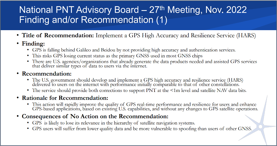
Image: Slide from the National PNT Advisory Board Meeting in November 2022
*The exception to difficulties funding civil GPS-related capabilities is the Federal Aviation Administration’s Wide Area Augmentation System. It was established as the result of heavy lobbying by the airline industry, which continues to give it strong support.
As we begin 2023, GNSS development continues apace, as described in this issue’s annual “Directions” section by representatives of Galileo, GLONASS, and BeiDou. We plan to publish a similar update on the GPS program soon.
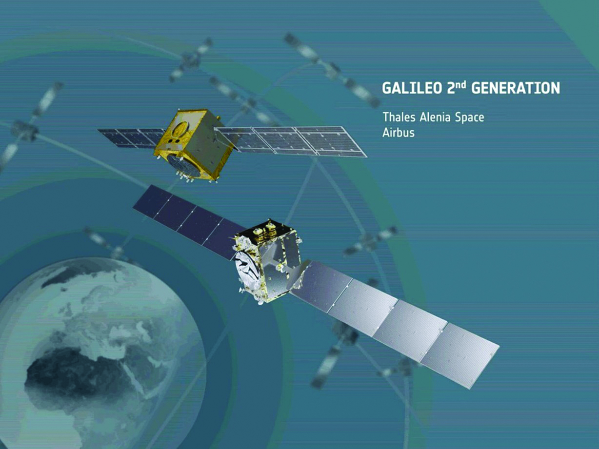
Galileo’s user base now stands at more than 3.5 billion, and the services it provides continue to improve and expand. Beginning early this year, free precise point positioning (PPP) corrections for Galileo and GPS (single- and multi-frequency) will improve real-time user position by up to 10 times. While the discontinuation of Soyuz launch services from the Kourou Space Centre in French Guiana, due to the Russia-Ukraine conflict, delayed the two Galileo launches that had been planned for last year, 2022 was a key year for the development of Galileo Second Generation (G2G) satellites. They will provide, among other innovations, a reconfigurable fully digital navigation payload, point-to-point connection between satellites, and advanced jamming and spoofing protection mechanisms.
On Nov. 29, 2022, Russia launched the 51st Glonass-M satellite, about 20 years after launching the first one. Currently, 13 of these satellites are operating beyond their guaranteed lifetime, with an average orbit lifetime of more than 10 years. Starting this year, the constellation will be renewed by Glonass-K and Glonass-K2 satellites, which provide CDMA signals to users.
Currently, 45 BDS satellites are operational in orbits, including 15 BDS-2 satellites and 30 BDS-3 satellites. The constellation says that it has reached a continuity of 99.996% and an availability of 99%, with a global positioning accuracy better than 1.5 meters horizontally and 2.5 meters vertically (95% confidence).
Tracy Cozzens, who has been a pillar of this magazine for 17 years, is retiring this month. We will miss her journalistic acumen, dedication to clarity and style, attention to detail, and wealth of institutional knowledge. We wish her a well-deserved retirement. At the same time, we welcome aboard Maddie Saines, our new managing editor, who is near the beginning of her career.
I am pleased to announce that Rob VanBrunt has joined GPS World’s Editorial Advisory Board. In mid-December, the board of directors of Spirent Federal Systems, a provider of PNT test solutions for the U.S. government and contractors, appointed him as the company’s president/CEO-designate, a role he will assume when the onboarding process is complete.
VanBrunt began his career at Spirent Communications in 1990 as product developer and manager, and then held posts of increasing responsibilities, moving to director and vice president roles focused on management, strategy and mergers and acquisitions. Most recently, he was executive vice president in the Office of Business Excellence. VanBrunt has a B.S. in electrical and electronics engineering from Rutgers University.
Spirent Communications is a global provider of automated test and assurance solutions for networks, cybersecurity and positioning. In July 2001, the company formed Spirent Federal Systems as a wholly owned subsidiary and U.S. proxy company. Spirent Federal markets and sells Spirent Communications’ products in North America. It also provides value-added features and ongoing customer support.
On Jan. 1, I lost my beloved mother, Maristella “Mimi” Luccio. She was 87.
In 2022, the Galileo GNSS continued to provide the world’s most precise satellite navigation information, to a user base that stands at more than 3.5 billion worldwide. Furthermore, provided services continue to improve and expand, with plans for high-accuracy positioning and signal authentication now reaching fruition.
The European Union Agency for the Space Programme (EUSPA) and the European Space Agency (ESA) continue to enjoy an effective collaboration on the many development, deployment, and evolution activities of the Galileo Programme — each according to their respective responsibilities for service provision and system development with the European Commission (EC) acting as the program manager.
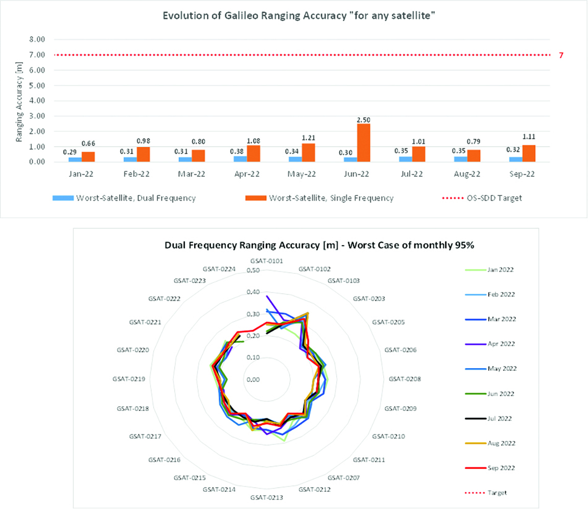
Ranging accuracy performance from January to September 2022.Positioning-related MPLS from January to October 2022.
New Services Launched in 2022
Excellent Performance
Service delivery operations and maintenance of operational systems are managed by EUSPA, which supervises many contracts that carry out the day-to-day activities from dedicated control and monitoring centers throughout Europe. In 2022, Galileo timing, navigation, and SAR/Galileo services were delivered with excellent performances that continue to exceed the formal declarations for minimum performance levels (MPL), which were increased in January, both in terms of absolute accuracy and overall service availability. The entry into service of two additional satellites in May and August, have further consolidated the overall service availability to end users.
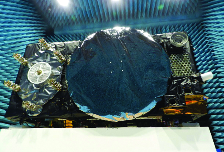
Galileo FOC Batch 3 satellite under testing.
Expansion of Service Portfolio
The service provision teams have been able to focus on improvements to, and expansion of, the service portfolio.
The I/NAV improvement will positively impact end users by enabling a faster time to first fix, and updates to the data validity status flags will lead to better protection of users against expired navigation data. These changes are implemented in updates of the onboard software of the satellites being rolled out across the constellation. At present, seven operational satellites have been successfully updated; the complete software upgrade campaign is planned to be completed this summer.
Galileo’s new High Accuracy Service will provide free precise point positioning (PPP) corrections, in the Galileo E6-B data component and by terrestrial means, for Galileo and GPS (single and multi-frequency) to achieve real-time user position improved by up to 10 times. The infrastructure to support an initial service (Phase 1) is nearing completion, and the formal declaration of the service capabilities is planned for early this year.
To provide users with a method of authenticating the received Galileo signals, especially the satellites ephemerides and the Galileo timing parameters, the new Open ServiceNavigation Message Authentication (OSNMA) service enables a receiver to confirm that a navigation message originated from the EU Galileo infrastructure. Many application areas are expected to benefit from this capability, including smart tachographs, telematics and logistics, UAVs, location-based services, and timing services. Having successfully demonstrated the technology behind the service in 2022, including a public observation phase, the roll-out of the Initial Service is planned to take place by the end of the year.
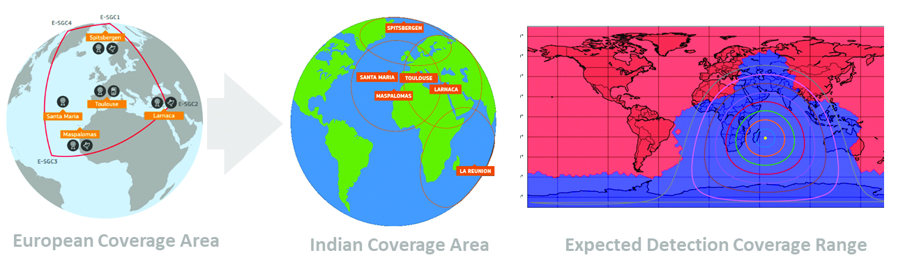
A fourth Medium Earth Orbit Local User Terminal (MEOLUT) in La Réunion will extend the SAR/Galileo Forward Link Service Coverage Area over the Indian Ocean as part of the SAR/Galileo full operational capability (FOC) declaration expected in the first quarter of 2023. The Cospas-Sarsat commissioning of this new station was completed in September 2022, and operational data is already being distributed to Cospas-Sarsat.
Reference documents for the above services can be found at the EUSPA European GNSS Service Centre website, including technical notes, interface control documents and service declaration documents.
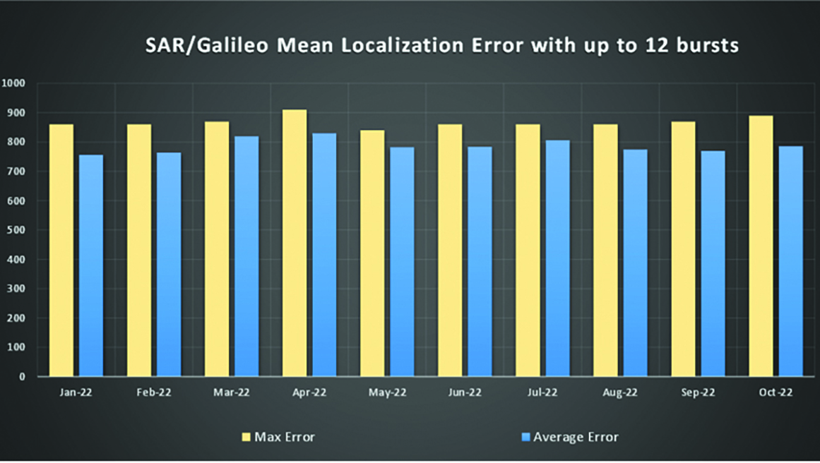
SAR/Galileo-related metrics from January to October 2022.Extension of the SAR/Galileo Forward Link Service Coverage Area over the Indian Ocean.
FOC Infrastructure Development Nears Completion
Satellite Production
The production of the third batch of Galileo FOC satellites advanced further in 2022 with the completion of the environmental tests and the system compatibility test campaigns at the European Space Agency Test Centre in Noordwijk, The Netherlands. After 10 years of successful testing, on Oct.18, 2022, the last Galileo FOC satellite (flight model number 34) left the test center to return to the premises of the satellite manufacturer, OHB Systems, in Germany. Testing of the remaining 10 satellites has confirmed that they have been correctly built and will perform well in orbit. The acceptance review of the last couple of satellites will take place this summer.
At the beginning of 2023, the plan is to start in-orbit testing of a quasi-pilot signal on the E5 frequency using the Galileo GSAT201/202 satellites in elliptical orbit. The provision of a signal offering coarse acquisition in Galileo E5-A/GPS L5 can be a distinguishing feature for Galileo with respect to all other constellations to further improve the capability to acquire the E5 signal at low complexity. Following in-orbit testing, the strategy for roll-out of this capability will be assessed with the involvement of receiver manufacturers.
New SAR Galileo MEOLUT facility in Réunion island.
Access to Space
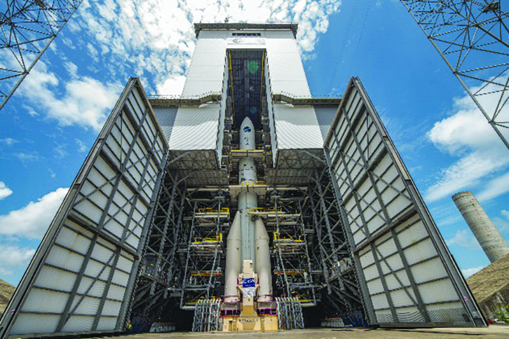
The discontinuation of Soyuz launch services from the Kourou Space Centre in French Guiana, because of the Russia-Ukraine conflict, has caused delays in the two Galileo launches that had been planned for 2022. The Launch 12 campaign had to be interrupted and in March 2022 the FM25 and 26 satellites were put in storage at the Kourou launch base, then returned to Europe in November.
Ariane 6 is the baseline launcher for Galileo satellites to ensure European independent access to space. The remaining Batch 3 satellites will be launched with the Ariane 62 launcher vehicle, the two strap-on solid booster variants of Ariane 6, now undergoing the final stages of development led by prime contractor Ariane Group. Ariane 6’s maiden flight is scheduled to take place in the fourth quarter of 2023.
Ground Segment
An upgrade of the ground control segment, in charge of command and control of the satellite constellation, is being developed by the industrial consortium led by GMV. The upgrades will address resolution of hardware and software obsolescence including cyber security, operability improvements, and a security monitoring overlay.
With the planned increase in the number of satellites in orbit, an additional telemetry tracking and control facility (TTCF) is being deployed in Kourou leading to seven operational TTCF stations in early 2023.
The ground mission segment, in charge of navigation control, is undergoing a complete technological refresh, including hardware/software virtualization performed by an industrial consortium led by Thales France. This upgrade will provide additional robustness, including a system extended contingency mode resilient to outages lasting up to seven days and a new state-of-the-art cyber security monitoring system. It will also provide ranging authentication through encrypted codes on the E6-C signal component for the implementation of the Commercial Authentication Service. Global coverage will be further increased with the introduction of two Galileo sensor stations in Wallis (Pacific Ocean) and Bonaire (Caribbean Sea), for a total of 15 sites around the globe.
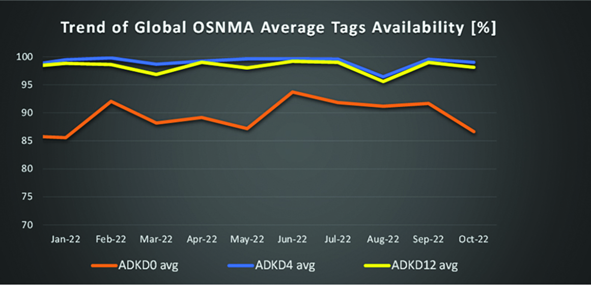
OSNMA-related metrics from January to October 2022.
G2G Development Started
Galileo’s second generation (G2G) will introduce many innovative technologies to offer unprecedented precision, robustness, and flexibility.
2022 was a key year for the evolution of G2G activities with the fast development cycles of the first batch of G2 satellites, beginning development of the associated G2G in orbit validation (IOV) ground segment and system test beds, and the consolidation of the G2G final system capabilities — including the coordination of the mission/service roadmaps with the EC, EUSPA, and the EU Member States delegates.
Ariane 62 launcher.
G2G Satellite Manufacturing
From the satellite development point of view, the two parallel contracts to develop and manufacture each of the six G2G batch one (G2SB1) satellites are progressing in a fast development environment, with the first hardware units ready for integration and testing.
Following the completion of preliminary design review, these two contracts (for six satellites each) are preparing for unit-level validation/testing, which will lead to the critical design review.
These satellites will provide the following key innovations:
Reconfigurable fully digital navigation payload
Point-to-point connection between satellites by inter-satellite-link for command and control, and ranging functionalities
Electric propulsion for orbit-raising capabilities
Advanced jamming and spoofing protection mechanisms to safeguard.
The Galileo signals will improve with:
On-board authentication capabilities
Increased ground-to-space data rate
Improved time reference (number of clocks and advanced clock monitoring functions).
G2G IOV Procurements
2022 was also the year in which two key events took place with respect to G2G in-orbit validation (IOV) ground segment and system test bed procurements:
Finalization of the procurement cycle, now in the final evaluation/award phase, to be kicked off in the first quarter of this year
Confirmation of the IOV design through different coordinated actions with the EC and EUSPA, including the G2 system preliminary design review.
The contracts will provide Europe with the following capabilities:
G2SB1 satellite launch and early orbit phase, in-orbit testing and enhanced legacy services provision
G2 new capabilities in-orbit validation, including prototyping and validation of all the novel technologies that can exploit the full capabilities of the G2SB1 satellites.
Eleven contracts will be issued to manage in synchrony all the G1 and G2 assets for the coming years:
G2 IOV ground control segment (G2 GCS) for satellites monitoring and control
G2 IOV ground mission segment/secured facility (G2 GMS-GSF) for the production, dissemination and monitoring of all enhanced legacy services and the dissemination of new G2 advanced capabilities for validation
G2 IOV security monitoring (G2 SECMON), for the cyber/security monitoring of the system
G2 filling device (G2 FD), to ensure proper initialization of system assets
G2 system test bed (G2STB), to generate and monitor new G2 capabilities for validation of the G2G mission/services
G2 PRS test bed (G2PRSTB), similar to G2 system test bed but focused on advanced PRS capabilities for validation purposes
G2 security chain (G2SC), a test bed to ensure proper satellite-ground segment qualification before launch
Four system engineering support contracts (G2 SETA), where the main GNSS technical experts from different industries in Europe provide their support to ESA and EUSPA in their different fields of expertise.
These contracts are complemented by a significant set of system research and development and test tools, such as test user receivers and radio frequency constellation simulators.
G2G batch number one (G2SB1) satellites.
Galileo Second Generation System PDR
The Galileo Programme is not only focusing on short-term G2G development activities, but also looking forward to the future in terms of the consolidation and definition of G2G final operation capabilities. During the second half of 2022, more than 200 public representatives from the EC, EUSPA, ESA and Member States held countless meetings in the frame of the G2G system preliminary design review, which concluded in early December 2022.
As part of this review, the long-term implementation (G2G in orbit capability, or IOC, and final operational capability, or FOC) was reviewed and an agreement was reached on future steps. The evolution of Galileo capabilities will not only provide better services through advanced technical solutions, but will also ensure continuity of service and enhanced backward compatibility for first-generation legacy users.
Conclusions
The efforts of ESA and EUSPA continue with the aim of providing users continuous and stable services and evolving space and ground infrastructure to maintain Galileo competitiveness with the other global navigation satellite systems.
For analogous updates on the other three GNSS constellations, please see:
The European Union Agency for the Space Programme (EUSPA) along with the European Commission, have published guidelines that specify the baseline applicable to the Galileo Open Service Navigation Message Authentication (OSNMA) receiver service provision phase. The new documents include the OSNMA Signal-in-Space (SIS) Interface Control Document (ICD), and OSNMA Receiver Guidelines.
The OSNMA SIS ICD specifies, among other things, the interface between the Galileo Space Segment and the Galileo User Segment. This document is an addition to the Galileo Open Service (OS) SIS ICD.
The OSNMA Receiver Guidelines provide generic instructions for the user segment implementation of the OSNMA functionality and complement the OSNMA SIS ICD. Additionally, the guidelines explain user capabilities and steps to implement to verify the authenticity of the Galileo navigation message.
Both documents will be used for the upcoming OSNMA Service Provision Phase that will begin after the OSNMA Service Declaration. They have been developed as an evolution of the Galileo OSNMA User ICD for test phase (v1.0) and the Galileo OSNMA Receiver Guidelines for test phase (v1.1). Copies of the documents can be found here.
On Nov. 11, the last Galileo satellite of first-generation series was shipped from ESA’s ESTEC Test Centre, Europe’s largest satellite testing facility. Galileo is Europe’s largest satellite constellation and one of the most accurate satnav systems in the world.
Galileo’s development began two decades ago with two test GIOVE satellites, followed by a series of other operational launches to add to the constellation. The current constellation consists of 34 Full Operational Capability satellites, the initial two GIOVE satellites, and the Galileo In-Orbit Validation satellite. Galileo Second Generation satellites are already in development.
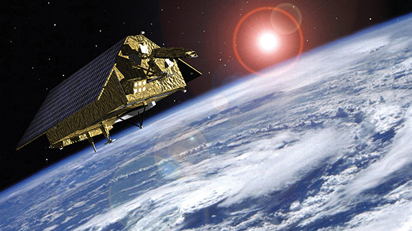
Sentinel-3 A&B CPOD Precise Platform data (AUX_PRCPTF)
The following new products from Sentinel-3 and Sentinel-6 are now available as well. The Sentinel-6A GNSS RINEX observations include GPS and Galileo data — the first publicly available Galileo data obtained from an orbiting receiver.
Sentinel-3A&B CNES Medium Orbit Ephemeris (SR___MDO_AX)
The GNSS RINEX (AUX_GNSSRD) and Quaternions files (AUX_PROQUA), together with the final orbital products (AUX_POEORB, AUX_PRCPTF, SR___POE_AX, and AX____POE__AX) are available at the beginning of each mission.
The other orbital products (AUX_RESORB, SR___ROE_AX, SR___MDO_AX, AX____MOED_AX, and AX____ROE__AX) are available for at least one month, until the final products are available.
The typical accuracy of the orbital products can be found in the Regular Service Reviews carried out by the CPOD Service quarterly.
The 2023 European Navigation Conference (ENC) will take place May 31-June 2 with a focus on resilient navigation. This conference, which will welcome professionals from the positioning, navigation, and timing (PNT) field, is organized by the Netherlands Institute of Navigation, a member of the European Group of Institutes of Navigation (EUGIN).
Given the growing vulnerability of satellite-based position and timing, the conference will focus on resiliency, which requires redundancy in the signal domain, terrestrial and space infrastructures, and on-board implementation — as well as addressing vulnerabilities in navigation functions, data, and guidance control.
Thanks to the hospitality of the European Space Agency, the ENC will be held at the ESTEC site in Noordwijk, The Netherlands, where the Galileo satellite system is designed and where navigation satellites are tested before launching.
The Ministerial Council of the member states of the European Space Agency (ESA) has pledged 351 million euros to ESA’s board of directors for navigation to aid in multiple satellite navigation endeavors.
This funding helps support ESA’s FutureNAV program, the Navigation Innovation and Support Program (NAVISP), and the Moonlight Initiative, developed for lunar telecommunications and navigation coverage and innovation.
The FutureNAV program is aimed at addressing the rapidly growing need for more ubiquitous, resilient and reliable positioning, navigation and timing (PNT). Its first mission consists of an initial in-orbit demonstration, small constellation of low-Earth-orbit (LEO) navigation satellites. The LEO-PNT satellites will test a multi-layer approach to deliver more accurate and robust PNT services, supplementing Galileo.
The second FutureNAV mission, GENESIS, will map the moving contours of Earth, while enhancing the accuracy of Galileo.
The expanded funding will also be invested in NAVISP. The program has already began working on over 200 projects relating to satellite navigation, PNT research, and backing Member States in research priorities.
Lastly, funding is being delegated to the Moonlight Initiative, a project designed by ESA to extend satellite navigation and telecommunications coverage to the Moon. The advancement and launch of Moonlight infrastructure on the Moon will undertake several missions bolstering future Moon exploration.
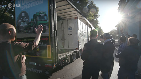
ESTEC Test Centre, Europe’s largest satellite testing facility, said goodbye on Nov. 14 to the final satellite in the Galileo First Generation series, as it departed to OHB in Germany. There, it will rest in storage until ready to be sent for launch.
In a new European Space Agency (ESA) video, the people responsible for readying the satellites for space have gathered to reflect on the end of an era.
The work on Galileo began two decades ago with two test Galileo In-Orbit Validation (GIOVE) satellites, followed by a series of operational launches. The two GIOVE satellites and all 34 Galileo Full Operational Capability satellites were tested at ESTEC.
Next will come the Galileo Second Generation satellites, already in development.