There was plenty for a philosophy major to sink his teeth into at ION’s January workshop on Cognizant Autonomous Systems for Safety Critical Applications (CASSCA).
What is knowledge? What is meaning? What is understanding? What is intelligence? What is learning? What is thinking?
These questions excited Plato and Kant, Buddha and Descartes, perhaps out of intellectual or spiritual curiosity. Who’s to say? But the people asking them now are driven, quite literally, by practicalities. They have come to realize that we cannot ride in driverless cars or fly in pilotless plane-taxis, we cannot live in an autonomous, artificially intelligent environment without knowing a bit more exactly what knowledge is, in this brave new world.
Without thinking about what thinking may be, for a machine.
Why does this matter to a GPS/GNSS/PNT readership? Because as positioning and navigation engage more deeply with artificial intelligence (AI) generally, and with autonomy in particular, these issues emerge as part of the environment that such solutions explore, and in which they must verify and validate themselves.
Welcome to the future, it’s yours. Now think about it.
Culture Club. Some of us may have believed that only technical obstacles remain in the path of a driverless car and an otherwise automated society, salted with a few regulatory wrinkles to iron out. But as build-a-robot R&D projects transform into full commercial partnerships, cultural challenges jump up as well: inertia, instability of requirements, unanticipated expectations, magical thinking (the development of empathetic attitudes towards robots), misplaced trust and misplaced distrust. All this according to Signe Redfield, roboticist and mission manager at the U.S. Naval Research Laboratory.
Joao Hespanha, professor of electrical and computer engineering at the University of California, Santa Barbara, outlined three key concepts for AI development: computation, perception and security. The critical questions for the first named are, how much computing will be done onboard the platform, how much learning will be done onboard, and how much of each process will be distributed to offboard computation. Perception, a crux for autonomy, is closely bound in a feedback loop with control. The platform must gather data to make autonomous decisions (control), and those decisions must maximize the gathering of information (perception).
Amply consider security. All safety-critical systems must provide for — and prevent where possible — decisions based on compromised measurements, which may stem from system or environmnetal noise, sensor faults, hacked sensors, or other corruptions.
Second Wave. We are in the second wave of AI, according to Steven Rogers, senior scientist for sensor fusion at the Air Force Research Laboratory. In the first wave, 60s and 70s, large and complex algorithms, relatively low on data, drove new developments — but they hit real-world problems, hard. Since the mid-80s, we have been in the “classify” stage with relatively simpler programs generating and consuming lots of data. Intense statistical learning will eventually lead to the third wave of AI: Explain.
On a timeline yet to be determined, contextual adaptation will give rise to “explainable” AI, capable of answering unexpected queries. That is, it will have learned how to teach itself.
Some of this stuff gets pretty scary.
Most future knowledge will be machine-generated.
Let’s run through that one more time.
“Most future knowledge on Earth will come from machines extracting it from the environment,” said Rogers. “Machine generation of knowledge is key for autonomy.”
Here’s where the thought processes really started to levitate. “Current sense-making solutions are not keeping pace, not growing as knowledge is growing,” Rogers asserted. And he challenged us with the questions posed at the beginning of this column: in AI, the context we will use to explore much of the future, what is knowledge? What is meaning? And so on.
He gave us one of his answers: “Knowledge is what is used to generate the meaning of the observable for an autonomous system. Correspondingly, machine-generated knowledge is what is used to turn observables into machine-generated meaning.”
Slide from Steven “Cap” Rogers’ presentation at CASSCA.
He suggested a book by George Lakoff and Mark Johnson, Metaphors We Live By. Pretty heady stuff for a room full of engineers. I don’t know about you. I’m headed down to the library to check it out.
Requirements, Simple/Not. We got back to earth with some technical challenges we could actually chew on with David Corman, program manager for Cyber-Physical Systems and Smart and Connected Communities at the National Science Foundation. Seemingly simple requirements for safety-critical applications break down into hundreds of requirements that no one has really thought about, Corman said, as he displayed a chart of “Some Example Research Problems.”
Precision agriculture and environmental monitoring are two sectors where he thought autonomous operations come closest to being full realization, because their operational environments are structurally defined enough. In such constrained niches that we more fully understand, we can implement autonomous operations. Elsewhere, “we don’t know how to specify what we want, so that we get only ‘good results’ and no ‘bad results.’ ”
He identified a looming Cambrian explosion in AI, analogous to that for plants and animas following the dinosaur extinction, in which systems interact, gather data, sense the environment, learn, improve and multiply. He suggested we browse “The Seven Deadly Sins of Predicting the Future of AI,” an essay by Rodney Brooks.
The afternoon’s workshop talks followed, from experts in autonomous flight software, legal and insurance aspects of autonomy, the Ohio State University’s Center for Automotive Research, and the U.S. Department of Transportation. But I tell you, this morning done my brain in.
Before folding up, I must mention a short video on autonomous flying taxis displayed by Paul DeBitetto, VP of software engineering at Top Flight Technologies. It depicts Pop.Up, a modular ground and air passenger vehicle for megacities of the future. Check it out.
The CASSCA workshop was organized and moderated by Zak Kassas, an assistant professor at the University of California, Riverside and director of the Autonomous Systems Perception, Intelligence & Navigation (ASPIN) Laboratory. He is also co-author of two cover stories in GPS World, “LTE cellular steers UAV” and “Opportunity for Accuracy.”
ION president John Raquet expressed the hope that we may see a fully fledged conference on this topic in the near future: CASSCA 2019, perhaps, to join the rotating repertory of ION annual meetings.
Agreed. We need to think more.
Don’t look back, the machines may be gaining on us.
EGNOS V3 will offer improved and secure Civil Aviation Safety of Life services for the next decade over Europe. The program will ensure a full continuity of service and will be the first operational SBAS using both GPS and Galileo.
Airbus has been selected by the European Space Agency (ESA) as the prime contractor to develop EGNOS V3, the next generation of the European Satellite Based Augmentation System (SBAS) planned to provide the civil aviation community with advanced safety-of-life services and new services to maritime and land users.
Developed by ESA on behalf of the European Commission and the European GNSS Agency (GSA), EGNOS V3 (European Geostationary Navigation Overlay Service) will provide augmented operational safety-of-life services over Europe that improve the accuracy and availability of user positioning services from existing GNSS (Galileo and GPS).
EGNOS also provides crucial integrity messages to EGNOS users with alerts within a few seconds in case of system degradation, consolidating EGNOS’ position as one of the leading edge GNSS systems in the future.
Besides improved safety-of-life services, EGNOS V3 will improve robustness against increasing security risk, in particular cyber-security risks.
EGNOS V3 will ensure a full continuity of service for the next decade and will be the first operational SBAS implementing the dual-frequency and multi-constellation world standard, with both GPS and Galileo, replacing EGNOS V2 which has been in operation since 2011.
“This programme is strategic for Airbus to strengthen our position in the Navigation field. The signature of this contract is the result of more than 5 years of intense team work and investment,” said Nicolas Chamussy, head of Space Systems at Airbus. “With our consortium, we bring a large pool of resources and experience in Europe covering the successful development of critical and secure ground segment. I am confident that we will make EGNOS V3 a success story.”
As prime contractor, Airbus will be leading a consortium with partners from France, Germany, Spain and Switzerland. Airbus will be responsible for the development, integration, deployment and preparation of EGNOS V3 operations, the overall performance of the system and the Central Processing Facility, which is the heart of the real-time navigation algorithms.
During the 6.5-year contract, around 100 people and 20 subcontractors will work on delivering the EGNOS V3 system. In 2023, the single-frequency version will be available to replace the current operational version and, 18 months later, the final version in dual frequency will be delivered.
EGNOS is composed of a large network of about 50 ground stations deployed over Europe, Africa and North America, two master control centers near Rome and Madrid, and a System Operation Support Centre in Toulouse. EGNOS will also use geostationary satellite navigation payloads.
The European Space Agency (ESA) held its annual Navigation Days on Jan. 26. ESA navigation specialists met with guests from the European Commission, European Global Navigation Satellite Systems Agency and European space companies at ESA’s technical centre in the Netherlands.
With Europe’s Galileo satellite navigation system only one launch away from full global coverage, representatives of the European space industry gathered at ESA’s centre in the Netherlands to discuss the transition towards the future Galileo Second Generation.
Galileo Initial Services began on Dec. 15, 2016, while the constellation in orbit has grown to 22 satellites. An Ariane 5 launch later this year of another quartet will bring the constellation to the point of completion with 24 satellites, plus two orbital spares.
A steady stream of orbital spares, ready to replace satellites reaching the end of their operational lives, is necessary to ensure Galileo continues operating seamlessly. A further 12 satellites were therefore ordered from industry in June 2017.
Paul Verhoef, director of the Galileo Programme addresses the audience at ESA’s annual Navigation Days, held Jan. 26. (Photo: ESA)
Looking further ahead, with the aim of keeping Galileo services as a permanent part of the European and global landscape, a replacement set of Galileo satellites will be required post-2020, serving as transition to a future generation.
The Galileo Second Generation is foreseen to offer improved performance and added features. This is why the European Commission has decided on a Transition Programme, with the European Space Agency (ESA) in charge of its technical definition and implementation.
Together with the European Commission and the European Global Navigation Satellite System Agency, the agency invited leading European space companies to its technical centre in Noordwijk for Navigation Days, held Jan. 26, to discuss Galileo’s future and present short-term plans in relation to this transition programme.
Having started with the ESA European Global Navigation Satellite System Evolutions Programme (EGEP), the system and technology development of Galileo Second Generation is being supported through the EU’s GNSS and Horizon 2020 HSNAV Programmes, with ESA being delegated its technical definition and management of its related implementation.
Eleven Phase-B contracts were signed at the meeting for the Design Phase for both the Galileo Second Generation and the Transition Programme, complementing the more than 50 technology contracts signed in 2017 to prepare for Galileo’s future.
In recent years, innovations have been analysed and predevelopments performed in various technology fields (system, ground, space, receiver technologies) in order to assess their suitability for future Galileo activities, while ensuring backward compatibility and continuity of Galileo Services.
In the next eight months, all major public and private stakeholders will be involved in the detailed assessment of the different evolution scenarios and associated technologies, in order to come to decisions on the Transition Programme baseline for the evolution towards Galileo Second Generation.
Satellite operator Iridium asked the Federal Communications Commission (FCC) in April 2017 to modify its license to add a new class of ground stations called Certus for expanded terrestrial, maritime and aeronautical operations.
Iridium’s 66-satellite constellation provides, in addition to mobile communications signals, the Satelles time and location service: microsecond timing accuracy and 20- to 50-meter unaided position accuracy worldwide (see the “Innovation” column, July 2017 GPS World).
GPSIA. The GPS Innovation Alliance (GPSIA) commented in September, “GPSIA seeks to ensure that radio navigation satellite service (RNSS) receivers operating in the 1559–1610 MHz band are adequately protected from out-of-band emissions (OOBE) generated from the new Certus mobile Earth station (MES) terminals that will operate on the second-generation Iridium satellite system.
“GPSIA and Iridium are actively engaged in constructive discussions regarding the adequacy of that protection, but no final resolution has yet been reached. [….]
“In the unlikely event that GPSIA is unable to reach an agreement with Iridium, it asks the commission to impose limitations on the operation of Certus terminal devices to protect GPS/RNSS operations in the 1559–1610 MHz band at a level equivalent to what terrestrial terminals in the same and other frequency ranges provide at –95 dBW/MHz.”
Iridium Certus infographic.
Hexagon. Hexagon, the parent company of GPS manufacturer NovAtel, commented on Jan. 8, “Certain statements in the modification application regarding output power and amount of terminals to be deployed cause great concern regarding the unimpeded operation of radio navigation satellite service (RNSS) receivers. The application does not include enough information to simulate the impact properly.
“Hexagon politely requests that the FCC will exercise the same due diligence [as] during previous modification applications close to the RNSS bands (for example docket 11-109) and establish a technical working group or a similar testing process that ensures unimpeded coexistence of the modified Iridium terminals with the established RNSS systems.”
Documents related to the case can be found here, on the FCC International Bureau website.
A security center for the European Union’s Galileo satellite system will be moved from the United Kingdom to Spain as a result of Brexit, according to numerous press reports.
A committee of representatives of member states voted by a large majority on Jan. 18 to approve the European Commission’s recommendation of Madrid as the Galileo Security Monitoring Centre’s (GSMC’s) new home.
The center, which is not yet fully operational, has only one full-time member of staff in Swanwick, England, but when it is up and running in Madrid, staffing is expected to grow to as many as 30.
The center controls access to the satellite system and provides around-the-clock monitoring when the main security center near Paris is offline.
The European Commission’s decision to move the center to Spain will bring Spain “strategic advantages, industrial development of high technological value, and the consolidation of national knowledge and technology in the area of security,” the Spanish ministry of public works said.
Spain was selected from six countries, according to Spanish media. It offers the facilities of the National Institute of Aerospace Technology (INTA), which belong to the defense ministry and are located in Madrid.
The GSMC is operated by the European GNSS Agency (GSA) in charge of supervising and acting on cases such as security threats and alerts.
Spain has another of the fundamental centers of the program, the Loyola de Palacio GNSS Service Center, also located in Madrid.
The center is one of a number of EU institutions leaving the UK as a result of the 2016 referendum vote, also including the European Banking Agency, which is relocating to Paris, and the European Medicines Agency, which is going to Amsterdam.
By Bradford Parkinson Vice-chair, U.S. PNT Advisory Board
In the coming months, the U.S. Federal Communications Commission (FCC) may allow high-powered, ground-based, communication transmitters to broadcast at a frequency near GPS L1. U.S. Department of Transportation (DOT) tests have shown that such transmitters effectively become jammers for many existing GPS receivers.
I believe that this possibility is the greatest current threat to the position, navigation and timing (PNT) community.
L1 is the primary band for GPS as well as for similar GNSS. For example, the international signal called L1C is to be centered at L1, albeit with wider spreading than the current L1 civil signal, C/A.
Why is this of critical importance? An economics study that only considered a small subset of benefits concluded that the U.S. alone realized $65 billion per year in direct economic value. A more complete recent study for the UK, extrapolated to the U.S., estimated the total impact of the loss of GPS to be over $3 billion per day for a five-day outage — a far greater rate. Virtually all GPS applications rely on the signals at L1. Thus, any threat to GPS is not simply an inconvenience, it would have great potential to do economic harm.
The PNT Advisory Board (PNTAB)has been trying to protect PNT, particularly GPS, and at the same time accommodate Ligado, a company that has requested repurposing of nearby spectrum. At our November meeting, we reviewed the Ligado proposal and framed a response that will be made public in due time. Meanwhile, these observations and conclusions are my own.
History
In 2011, LightSquared proposed that existing restrictions on its existing frequency authorization in the Mobile Satellite Service (MSS) band (a faint signal, satellite-to-ground) be waived so that the band is effectively repurposed to allow for high-power terrestrial transmissions.
The company has two space-to-ground authorizations in the 1525–1559 MHz band (1526–1536 MHz and 1545–1555 MHz) very close to the GPS primary frequency (L1 at 1575MHz). Initially it requested repurposing to ground transmission of 42 dBW (15.8 kW).
Faced with tests and analysis that showed this would be very destructive to GPS, it proposed to abandon the closer band and reduce power in the further band to 32 dBW, or 1580 Watts.
Ligado filings suggest a spacing of approximately ¼ mile between transmitters. A GPS receiver would find even these weaker signals 5 billion times the power of GPS at the maximum range of ¼ mile.
Most PNT users would be much closer.
International criterion
To ensure ranging accuracy, the international standard for interference to GPS is a 1-dB increase in noise levels. In conventional terms, this max allowable 1 dB is a 25.8% increase in background noise. The power of the weak GPS signal is only about 1% of the background radio noise. Sophisticated signal processing algorithms allow the signal to be reconstructed.
The result: the international 1-dB standard is equivalent to a 25% reduction in GPS radiated power.
Two additional points
The 1 dB is not simply to protect signal lock, it is to protect ranging accuracy. Most GPS receivers will stay locked for higher levels of interference but lose high precision. This is particularly a problem for high-precision receivers, which need relative timing to sub-nanosecond accuracies.
These measurements are equivalent to the time it takes light to travel ¼ inch. Protecting such accuracies is of paramount importance to PNT users and applications.
Allowing such maximum degradation from a single source is not the whole picture. There are many other potential sources of interference and attenuations of the GPS signal. For example, foliage may reduce the GPS signal.
A receiver must cope with all of these difficulties. Allowing a single cause, such as the Ligado repurposing, the 25.8% equivalent reduction might be considered quite generous, but it is the accepted International Standard.
Ligado has specifically rejected this criterion, largely because testing has shown that the Ligado repurposing would then be unacceptable for many PNT user classes.
To support its rejection of the International Standard, Ligado has repeatedly alleged that five of the major manufacturers are in complete agreement regarding its repurposing. This is a substantial distortion. The record was set straight by Brian Ramsay of MITRE at the November PNTAB meeting: “Four of the five parties that reached agreements with Ligado (except for Topcon Positioning) support the 1-dB Interference Protection Criterion (IPC) in comments filed in response to this Public Notice.”
Further support was highlighted by Captain Robyn Anderson: “In June 2017, the Air Force produced a white paper on the 1-dB IPC that explained the relationship between harmful interference (levels that affect GPS receiver performance) and the 1-dB IPC (keeps interference below a level that would cause harmful interference).”
Lightsquared’s motivation in 2011 was clear: a $10 billion windfall profit (estimated increased value of the spectrum on open-market auction). The FCC did not confirm Lightsquared’s modified request, and in 2012 the company went into bankruptcy.
Reorganizing as Ligado and emerging in December 2015, it continued to pursue repurposing of its spectrum, sponsoring tests by Roberson and Associates, and tests at National Institute of Standards and Technology (NIST)/National Advanced Spectrum and Communications Test Network (NASCTN) to establish test procedures.
Both groups of tests were carefully reviewed by our PNTAB who found serious flaws. In general, Ligado rejected the 1-dB criterion and did not accept the need to protect all classes of users, particularly high-precision receivers. In addition, it did not consider the new GPS L1 signals (L1C and L1M), nor did it check the impacts on the international GNSS. The PNTAB assembled a 14-point summary of deficiencies and requested updates and corrections for the flaws.
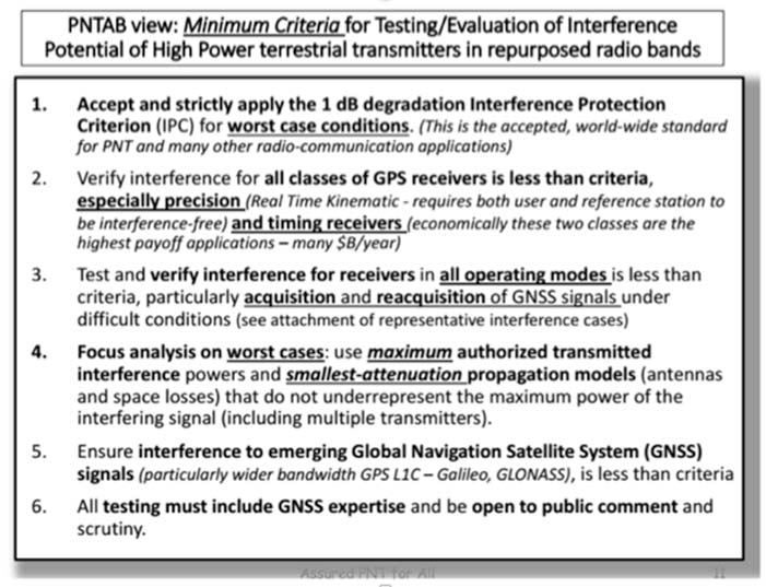
NASCTN’S response did not really address the points, or claimed that there were no funds to correct the problems. The PNTAB then developed a Six-Point Criteria for acceptable interference testing,summarized as:
Accept and strictly apply the 1-dB criterion.
Verify interference for all classes of receivers.
Test and verify for all operating modes.
Focus analysis on worst cases.
Include the new GNSS signals.
Include GNSS expertise and openly publish results.
Image: PNTAB
We believe it is a very reasonable set that aims to protect PNT users and our economic benefits. In its sponsored tests, and in representations to the FCC, Ligado has consistently overlooked a basic facet of radio ranging: it is ranging accuracy, not simply locking onto a signal, that is the fundamental objective for PNT.
Both Ligado test sets clearly failed on all six points.
DOT ABC tests
While the Ligado-sponsored tests were neither independent nor adequate, the Department of Transportation, led by Karen VanDyke, sponsored a very complete set of independent tests; these are the most credible estimates of harmful interference. The ABC results have been made public. The PNTAB’s six points were published after DOT testing had begun, but DOT expanded and modified their effort to satisfy the criteria. The DOT conclusions, based on modeling real-world antennas and propagation patterns, are shown in Table 1.
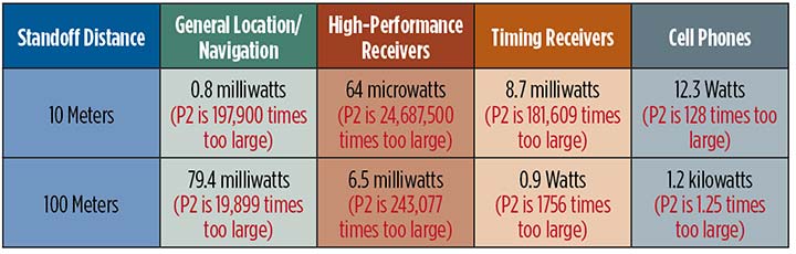
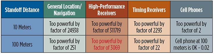
TABLE 1. DOT ABC test results. Maximum tolerable effective radiated power (EIRP) for classes of the most susceptible GPS receivers for modified Ligado proposal (P2) of 1.58 kilowatts. In red are the factors that Ligado P2 exceeds the maximum tolerable radiated power. (Chart: GPS World)
At 100 meters, all classes of receivers tested had results that would exceed the 1-dB threshold, even for the reduced power level (P2, 1580 Watts) that has been the most recent filing. The shaded square is particularly troublesome. It shows that, for the most susceptible high-precision receivers, the Ligado proposed power exceeds the 1-dB threshold by over 200,000. This result is particularly damning for the proposed repurposing, because it is this class that produced the highest payoff in the recent Department of Commerce Study — over $30 billion per year.
PNT operations at risk
These are examples of unintended and potentially hazardous consequences of repurposing.
UAVs. Unmanned aerial vehicles (drones) will fly very close to the dense array of transmitters that Ligado would deploy. They usually require GPS for flight control. Even more important, if we are to monitor them and keep them from collisions, GPS offers the only viable techniques with 3D accuracy and almost 100% availability.
Precision survey. This is routinely used in urban areas for building construction and is a major source of productivity gains. These survey receivers are all high precision and routinely make measurements to better than ¼ inch.
Helicopters. These are found in urban area at all altitudes. They are used for law enforcement, rescue and passenger transportation. GPS is mainly used for general navigation.
Public safety vehicles. Fire, police and ambulances use GPS for both navigation and dispatch tracking. In a city, they would drive in and out of susceptible high-interference zones.
The PNTAB believes the DOT results are representative, accurate and credible. The National Coordinating Office for PNT also sponsored an evaluation of all testing to date. A summary report is now in coordination, as a combined Department of Defense (DOD) and DOT effort.
The DoD, which uses GPS in the national airspace for routine flight, testing, training, guiding rocket launches, and for humanitarian rescue missions, has opposed repurposing. The Air Force reported, “Results from the DOD ABC Assessment support the conclusions drawn from Department of Transportation’s ABC Assessment.”
November PNTAB meeting
At our November meeting, the board invited Ligado to make a presentation on its repurposing proposal. The invitation said: “Specifically describe your implementation plan, with a corresponding test plan addressing the issues we have openly raised. We request you specifically focus on those regarding the potential for interfering with any GPS/GNSS services that operate in the protected space-to-Earth L-band (1559–1610 MHz). Included should be all modes of operation and the use of all current and future GNSS signals.”
Valerie Green, executive vice president and chief legal officer of Ligado Networks, represented Ligado. In the run-up to the meeting, the Six-Point Criteria had been sent to Ligado. Green did not address the six points at all.
She did offer to reduce initial power to “the safe power level in the 1526–1536 MHz channel ranges from 9 to 13 dBW EIRP nationwide,not just near airports.”
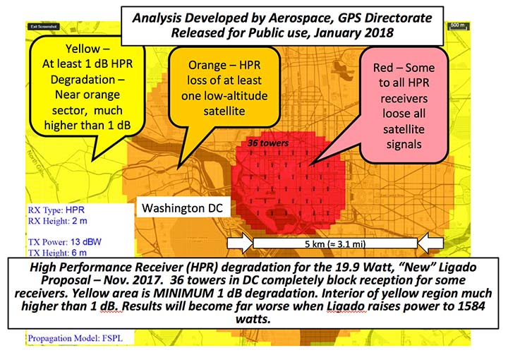
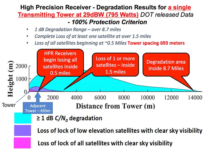
FIGURE 1. Potential impacts on high-performance receivers. Red: loss of lock of all satellites. Yellow: loss of lock of low-elevation satellites. Green: 1-dB degradation. (Chart: PNTAB)
The 13 dBW corresponds to initial power levels of 19.95 W. However, Ligado has made clear in its FCC filings that it ultimately still wants a full 32 dBW base-station transmit power level, consistent with typical 4G/LTE networks.
The initial reduced power sounds like a major move in the right direction, but further questioning revealed two major issues:
Tower Spacing. Green was very evasive on the spacing of transmitter towers. Clearly, at the reduced power level, greater density would be needed to carry the original data bandwidth. At about 1/100th the power, density would have to increase by a factor of 100, and the spacing would have to decrease to 1/10th for the same data output rate.
Green referred us to an earlier filing which specified 0.25 mile, but did not clearly state that this was the plan; she claimed the details were proprietary. If this fundamental parameter, spacing, is not specified, it is hard to see the basis for the FCC evaluation of any new proposal. If the transmitter spacing is reduced to less than 1/10th of a mile, the sources of potential harm would be multiplied in a very worrisome way.
Future power constraint.A public presentation does not ensure that Ligado will actually file and agree to abide by those power constraints indefinitely. Board members pressed Green on the permanence of the power constraint.
She suggested it would be tied to the RTCA Minimum Operational Performance Standard. Revising the MOPS takes many years, if not decades, both to formulate and to implement. Retrofitting the commercial aircraft fleet is very expensive and time-consuming.
Further, her statement focuses only on commercial aircraft, ignoring the high-precision classes as well as future signals.
A modified summary chart (Table 2) for the lower power, based on the DOT ABC test results, shows that even at the lower power, the threshold for high-precision receivers is exceeded by a factor of over 3,000 at 100 meters. In fact, only cell phones, which are relatively inaccurate, could operate at 100 meters without exceeding the threshold.
TABLE 2. Results of DOT ABC test with Ligado transmitters constrained to 19.95 Watts (13 dBW). This illustrates that the International Interference Limit is exceeded many times over at 100 meters for certain high-precision receivers, highlighted in red. (Table: GPS World)
With these expectations and uncertainties, the PNTAB did not find the new revision acceptable to the PNT community.
Three fundamental issues
Ligado has steadfastly not accepted the realities of non-interference.
1 dB. Acceptance of the 1-dB (25.8% noise increase) International Interference standard is fundamental to protecting GPS applications throughout the country.
All current and future uses. Users of great concern are emergency services, helicopter and general aviation, UAVs, and precision survey and machine control. For example, many of the underground utilities in the U.S. have been mapped with precision, GPS-based, geographic information receivers. This application requires sub-meter accuracy and operates in both rural and urban environments.
Ligado has tended to simply focus on certified aviation, claiming that protecting that class of user is enough. The PNT community rejects that view. All current and future PNT users must be protected.
Worst–case interference. The recent round of testing was largely in a laboratory. Extrapolating to the real world must examine the situations with greatest interference. For example:
Number of simultaneous interfering transmitters. A single transmitter situation is not typical; three or more are apt to be in range. The additive power must be considered.
Propagation models. Propagation models for communications differ from those for evaluating potential interference to a navigation signal. For assured communication, a typical model assumes transmitted signal fall-off a little faster than 1/(distance squared). Ligado would naturally prefer to use this model, which is far from worst-case for interference. The early round of tests in Las Vegas verified the communications model would vastly underestimate interference levels, by factors of 10 or more. A more realistic model must be used.
Degradation Radius. This is the size of the circle within which the International Standard is violated for receivers in a specified class. If the spacing of transmitters is 400 meters, and the degradation radius is 200 meters, virtually all receivers are in the degradation zone. Ligado suggested an appropriate degradation radius is 250 feet for aviation (approximately 100 meters). Thus, they claim the PNT community should tolerate violation of the standard when closer than 100 meters to their transmitters. At 400 meters spacing, 25% of the area would be in violation.
But the ABC test results reveal a much graver situation. They show that, for the current Ligado proposal (1580 watts), the degradation radius is over 14 kilometers for high-precision receivers. See Figure 2.
The 1-dB criterion is the correct, accepted and somewhat generous allocation of interference that can be accepted by the PNT community. We would hope that the FCC would continue to insist on this standard.
PNT users must, yet again, defend the spectrum vigorously. Most of us are scientific and technical people. We are not used to discussions that deliberately avoid the technical issue or deny scientific evidence. We reject arguments that violate the fundamental laws of physics.
The currently filed proposal, 1580 Watts at spacing of ¼ mile, is unacceptable. It will do grave harm to many important PNT applications
We must be very leery of the new proposal by Ligado of 9–13 dBW. It still would violate the 1-dB criterion at 100 meters for many PNT users.
Moreover, the company history has been to bait and switch; it has an authorization for MSS Ancillary Terrestrial Component (MSS ATC) stations to fill the gaps in satellite coverage with ground transmitters. These must operate in conjunction with the space-to-ground link that made them effectively self-limiting. However, in 2011, it almost succeeded in switching this to a ground-only system, which would have achieved a huge financial windfall.
Open-air verification
If the FCC continues to consider this proposal, there is one step that it should take before granting it. It should require Ligado to deploy an array of transmitters in its advocated configuration, and run real-world, open-sky testing to assess the harm that may result, particularly to high-precision accuracy.
Such testing was done when the issue was first raised in 2011 and conclusively demonstrated unacceptable interference. Nothing has really changed from the baseline that was tested and found unacceptable then.
The company should carry the full financial burden of such a verification, under PNT supervision. The government, having already spent millions of dollars to defend the spectrum, should not bear the cost of such retesting.
Without this confirmation, it is hard to conceive of putting GPS and PNT at significant risk to satisfy investors who want to flip a company, after gaining “rezoning” permission for their spectrum.
From 20,000 feet altitude
If we examine the situation without the technical details, we have this: Fundamentally Ligado wants to provide service using its allocated frequency band for an unlimited number of Internet-of-Things installations.
It is not proposing a small, fixed number of transmitting towers located in isolated regions, but rather an accelerating deployment of private networks, many of which will be close to commercial and essential infrastructure where GPS use is critical.
It seems unrealistic that Ligado can or will reliably guarantee that these widespread installations will be continually adjusted and monitored to avoid GPS interference.
I believe the concept of allowing the installation of transmitting towers that, by design, will interfere with normal GPS use at some distance away opens the door to tacit approval of short-range (or not-so-short-range) GPS jammers.
While I can commend the entrepreneurial spirit, the Ligado proposal seems very reckless indeed. The incremental value of an additional broadband transmitting system when there are at least five already in existence seems trivial compared to the potential damage done to the modern utility named GPS.
I sincerely hope the FCC can find a spectrum swap or deny outright the current Ligado application.
GNSS testing solutions company Spirent Communications has added BeiDou Phase 3 signals to its GNSS RF constellation simulators.
BeiDou Phase 3 signals are available immediately on the GSS7000 and GSS9000 simulators, and existing users can obtain the software upgrade by contacting Spirent.
The addition of these new signals to the GSS7000 and GSS9000 simulators follows the launch of the first two Beidou-3 satellites in November 2017. Two others were launched Jan. 12.
Phase 3 of the Chinese BeiDou system will extend its coverage from Asia to the entire world. It will provide receiver developers and integrators with additional GNSS signals to make positioning, navigation and timing systems more accurate, and help to support new applications, such as autonomous vehicles.
The new signals will use the same carrier frequencies as the GPS and Galileo systems, so chipset manufacturers and device developers will need to test integrated designs to avoid problems caused by confusing data from different GNSS.
“By offering the BeiDou Phase 3 signals, our customers can test their designs well before the system is fully operational, which is expected in 2020,” said Stuart Smith, lead product manager at Spirent Communications. “With signals already starting to appear, it is important for developers to have test tools that can ensure devices will successfully make use of all GNSS signals.”
China launched twin BeiDou-3 navigation satellites into space on Jan. 12 as part of efforts to enable its BeiDou system to provide navigation and positioning services to countries along the Belt and Road by the end of 2018, reports XinhuaNet.
China’s Belt and Road Initiative aims to create the world’s largest platform for economic cooperation.
The pair of satellites was launched at 7:18 a.m. local time aboard a Long March-3B carrier rocket from Xichang Satellite Launch Center in southwest China’s Sichuan Province. The twin satellites are coded the 26th and 27th satellites in the BeiDou Navigation Satellite System.
This is the first launch of the BeiDou satellites in 2018, which will see intensive launches throughout the year.
The twin satellites are coded MEO-7 and MEO-8, the 26th and 27th satellites in the BeiDou Navigation Satellite System.
Following the successful launch of the third-generation BeiDou satellites, ComNav Technology has been tracking and decoding the BD-3 satellite signals to provide better high-precision positioning services in the near future.
As the world’s fourth navigation satellite system, the construction of BeiDou satellite navigation network consists of three steps: experimental period from 2000 to 2003, regional coverage by 2012, and global reach by 2020.
On Nov. 5, 2017, the launch of two third-generation BeiDou satellites indicates that China has begun to upgrade its BeiDou Navigation Satellite System with global-coverage capabilities, according to the China Satellite Navigation Office.
The new-generation BeiDou satellites feature better accuracy, stability and signal clarity, thanks to improvements in laser communication devices, intersatellite links and atomic clocks.
Moreover, 18 third-generation BeiDou satellites will be launched by the end of 2018 to cover all nations involved in the Belt and Road Initiative. By the end of 2020, worldwide high-precision GNSS users are able to benefit from global reach of the third-generation Beidou system.
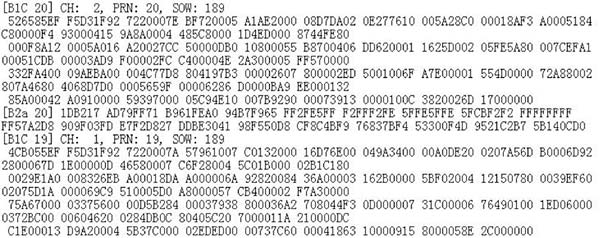
ComNav Technology has tracked and decoded the latest format BD-3 satellite signals: B1C and B2a from satellites Beidou-19 and Beidou-20.
The following figure shows the BD-3 No. 20 signal tracked with the SinoGNSS K708 GNSS OEM board.
Chart: ComNav
According to ComNav, with its strong R&D capability in high-precision GNSS, ComNav Technology plans to grow with the third-generation BeiDou navigation system to bring better positioning services all the time.
With the successful launch of newest BeiDou-3 navigation satellites, Beidou’s pace of globalization is quickening. As a provider of China’s domestic GNSS core products, Unicore Communications brought its full range of products to the Consumer Electronics Show (CES), which took place Jan. 9-12 in Las Vegas.
Unicore’s exhibits are targeting intelligent drive and the internet of things (IoT).
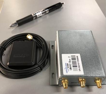
For intelligent drive, Unicore is showcasing its UM482 high-precision GNSS module, which is designed for high-end L3 self-driving and robots.
Unicore also is introducing a cost-effective low-power GNSS module — UM442 — which is suitable for L2 ADAS applications and community-based GNSS navigation and maps.
UM442 is a cost-efficient high-precision real-time kinematic (RTK) and heading module that can simultaneously track GPS, BDS, GLONASS and Galileo. It also supports SBAS and QZSS.
Based on high-performance data-sharing technology and the simplified operation system of the Nebulas II chip, the UGypsophila RTK algorithm dramatically optimizes matrix processing. Therefore, the UM442 can track many more satellites and shorten the initialization time to 5 seconds.
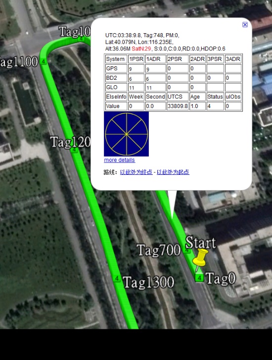
Satellite view during a UM442 road test using the UGypsophila RTK algorithm. UM442 achieves centimeter-level RTK positioning using a low-cost ceramic antenna.
With on-board MEMS and the U-Fusion integrated navigation algorithm, UM442 can achieve accurate and reliable positioning even in the most challenging environments such as urban canyons and tunnels.
UM442 also provides attitude information such as rolling angle and pitching angle, which is suitable for many new applications such as community-based navigation maps and ADAS. Even with a low-cost ceramic antenna, the UM442 can achieve centimeter-level RTK positioning, as well as a 0.2-degree/1-meter baseline heading accuracy.
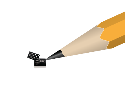
At CES, Unicore plans to introduce BeiDou products into the large volume market of consumer electronics. Ufirebird is an ultra-small, ultra-low-power multi-GNSS positioning system-on-chip (SoC), using 28-nm technology. The chip supports BDS, GPS, GLONASS and Galileo signals, and the software can be extended to support WAAS/QZSS/EGNOS/MSAS/GANGAN enhanced signals.
Unicore’s UFirebird-UC6226 low-power GNSS SoC is designed for mobile devices.
Two packaging methods are available: WLCSP and QFN40. For WLCSP packaging, the chip size is only 1.73 x 2.87 mm, and for QFN40 packaging, the chip is AEC-Q100 compliant, aimed for highly reliable automotive-grade applications.
UC6226 is equipped with a built-in sensor hub capable of providing access for multiple sensors for fusion positioning. It supports Wi-Fi, Bluetooth, GNSS hybrid positioning, and better than 1-m differential positioning accuracy.
Compared with Unicore’s previous generation GNSS SoC, UC6226 has reduced power consumption by 60%. The minimum tracking power consumption is lowered to 18 mW, significantly improving battery endurance.
With a built-in anti-jamming module, LNA and -162dB sensitivity, UC6226 can maintain accurate and precise positioning under complex environments.
UC6226 has been successfully applied by China’s bicycle sharing companies. In addition, the chip will be used in intelligent watches, smartphones, smart cameras and many other IoT devices requiring smaller size, lower power consumption.
The upcoming annual conference sponsored by the IGNSS Society will take a close look at autonomy and provide GNSS constellation updates.
IGNSS is the southeast Asian region’s premier conference on GNSS and related position, navigation and timing (PNT) technologies.
This year’s conference theme is “Trusted Positioning: From Here to Autonomy.” The event, sponsored by Lockheed Martin, takes place Feb. 7-9 on the campus of the University of New South Wales in Sydney, Australia.
At the conference, leaders in GNSS and PNT will gather to examine the latest technology, present cutting-edge research and discuss in open forums the implications for policy, market development and positioning infrastructure deployment.
IGNSS 2018 will showcase a number of contemporary topics, including
the role of PNT in automated land, aerial and marine vehicles;
the growing range of commercial precise positioning services;
hard infrastructure issues such as space based augmentation systems; and
soft infrastructure issues such as datum modernization and mitigation of system vulnerabilities.
These topics will be discussed in the context of the latest system developments fueling the multi-GNSS era.
Running over two days immediately prior to IGNSS2018 is a meeting of the RTCM SC-104; all attendees are invited to attend.
Also running one day before IGNSS2018 is the Japan-Australia Quasi-Zenith Satellite System Industry Utilisation Workshop. IGNSS delegates are also welcome to attend this free workshop.
The IGNSS conference takes place on the UNSW campus in Sydney. (Photo: University of New South Wales)
IGNSS2018 Highlight Sessions
Global GNSS service provider updates
SBAS Testbed overview and project updates
Panel: positioning autonomous systems
Keynote Speakers
Air Vice-Marshall Kym Osley, Department of Defence
Kent Rosser, Discipline Leader Aerial Autonomous Systems, DST Group
Dorota Grejner-Brzezinska, The Ohio State University
Joe Burns, Sensurion
Rod Bryant, u-blox
Kendall Ferguson, RTCM Board of Directors & SC-104 Chair
Representative from the Expert Reference Group conducting the Review of Australia’s Space Industry Capability
Representative from the iMove CRC
The IGNSS Association runs the SE Asian region’s premier conference on Global Navigation Satellite Systems and related Position, Navigation & Timing technologies. This year’s IGNSS is hosted in conjuction with the Australian Centre for Space Engineering Research at UNSW Sydney.
Q: How will safety issues raised by increasing autonomous traffic — in the air and on roads — affect the GNSS industry?
Sanchit Agarwal, VP, Field Operations, Nearmap
A: Due to increasing autonomous traffic, the GNSS industry will have to adopt the concepts of collective tracking mechanisms in the shared ecosystem. Inherently, all the cars/drones (rovers) will have the sensors to track the traffic “on-the-fly” and make intelligent navigation decisions, but in case of any system malfunction, the collective tracking of devices can facilitate “social” interactions between the rovers. This will serve as an added layer of security in case an autonomous social member goes rogue!
Zak M. Kassas, Assistant Professor, University of California, Riverside
A: Future autonomous vehicles will demand full situational awareness and extremely reliable, accurate and secure navigation systems. GNSS will not meet the stringent demands of these autonomous vehicles. To address the inevitable situations where GNSS signals become unusable (due to attenuation or interference) or untrustworthy (due to spoofing), receivers should be coupled with sensors such as IMUs, lidar and cameras, and exploit the plenitude of ambient signals of opportunity such as cellular, digital TV and Wi-Fi.
Jonathan Auld, VP of Engineering and Safety Critical Systems, Novatel
A: Safety issues raised by increasing autonomous automotive and airborne traffic will escalate the product development standards and performance requirements of GNSS software, hardware, and correction services used. The GNSS industry is challenged to increase accuracy on lower cost platforms by utilizing multi-frequency, multi-constellation, sensor fusion and precise point positioning. To be able to rely on GNSS in auto-guidance applications, the industry also needs to incorporate GNSS integrity functionalities into our products.