The United States and China have negotiated compatible signal characteristics that will both protect and enhance service for users of the U.S. GPS and Chinese BeiDou constellations.
The achievement resulted from several years of discussions between U.S. and Chinese GNSS experts. The consensus to make the systems compatible and interoperable at the user level will mean better service for users of both systems worldwide.
The U.S.Department of State’s Bureau of Oceans and International Environmental and Scientific Affairs Office of Space and Advanced Technology represents the United States in the ongoing U.S.-China GNSS Cooperation Dialogue, which began in May 2014 and covers various topics.
Compatibility of the Chinese BeiDou Navigation Satellite System (BDS) with GPS has been a core focus of the discussions. The U.S.-China Joint Statement on signal compatibility and interoperability is below and on the gps.gov website.
Joint Statement on Civil Signal Compatibility and Interoperability Between the Global Positioning System (GPS) and the BeiDou Navigation Satellite System (BDS)
December 4, 2017
In May 2014, China Satellite Navigation Office and the Office of Space and Advanced Technology, U.S. Department of State, jointly established the U.S.-China Civil GNSS Cooperation Dialogue, a bilateral government-to-government mechanism to promote cooperation between the U.S. Global Positioning System (GPS) and the Chinese BeiDou Navigation Satellite System (BDS).
Over the past three years, representatives and experts from both sides have studied and discussed various topics related to civil service provision and user applications, among which BDS compatibility and civil interoperability with GPS is one of the core focus areas.
Both sides have carried out extensive in-depth analysis, and have engaged in persistent discussion and coordination.
As a result, the two sides have reached the following consensus conclusions regarding compatibility and interoperability between GPS and BDS:
Consistent with the bilateral frequency compatibility coordination completed in 2010, GPS and BDS are radio frequency compatible under the framework of the International Telecommunication Union (ITU); and
The GPS L1C and BDS B1C civil signals, using two different types of multiplexed binary offset carrier (MBOC) waveforms are interoperable, which means users can receive better service by jointly using these civil signals without a significant increase in receiver cost or complexity.
Both sides agree to continue their consultations and cooperation related to compatibility and interoperability in order to provide better services for global users.
(signed by)
Ran Chengqi, China Satellite Navigation Office
David A. Turner, Office of Space and Advanced Technology, U.S. Department of State
For more information, contact [email protected]. Follow the Bureau of Oceans and International Environmental and Scientific Affairs on Twitter at @StateDeptOES.
Opening remarks by Alan Cameron, editor and publisher of GPS World
Everyone at this great conference is actively engaged in innovation: new approaches, new combinations, new integrations, new methodologies.
Our sponsors are not only innovators, they are active in building those innovations in the field, installing the cornerstones of GPS and GNSS technology. Harris Corporation has been building the GPS satellite payloads since the beginning of time, Rockwell Collins has built so much user equipment, historically and currently, and Spirent Federal Systems has been enabling the development and testing of much user equipment by many companies in this room.
Just to give you an idea of who else is seated among you at the tables, we have NovAtel, Spectracom, IFEN, Septentrio, Satelles, Syntony, Unicore, u-blox, ComNav, RaceLogic, Rohde & Schwarz, ublox, Locata, GMV, Leica, Thales, Boeing, Broadcom, Qualcomm, Google, Apple, Intel, MITRE and Aerospace Corporation; the U.S. Air Force GPS Directorate, the U.S. State Department, the European Space Agency, the European GNSS Agency and the European Commission, NASA, the French and German aerospace agencies; the Institute of Navigation and the Royal Institute of Navigation; and universities and research institutes almost too many to number.
This is a great industry to be part of, and I feel lucky to be kind of a spectator, a commentator in it without the benefit of the scientific upbringing that everybody else in this room has had. I still get to participate in the excitement and the developments and for that I am truly grateful.
Satellites Leadership Award
Galileo Builder
Wolfgang Paetsch
Director of Navigation and Member of the Executive Board, OHB
For his leadership in setting up the routine production of the Galileo satellites leading to Galileo constellation deployment, including thequadruple Ariane 5 launch in November 2016.
Paul Verhoef (right), director of the Galileo Programme and Navigation-related Activities, European Space Agency, accepted the award and delivered remarks on behalf of Wolfgang Paetsch. (Right photo: Melanie Beus)
Introduction by Rob Scott, Rockwell Collins
“Forty years ago, Rockwell Collins celebrated the first receipt of a GPS signal,using a six-foot tall, two-person receiver. Now we have something something 1 by 1-1/4 inches that is far more capable. It’s amazing to see how technology has advanced.”
Remarks by Wolfgang Paetsch
I must admit I am rather at fault for Wolfgang not being here, because I keep him rather busy producing satellites, as OHB is completing the last of 22 satellites under contract from ESA. We are going to launch again in December, as you know we have had a few problems, which I’m glad to say we have solved. The issues are behind us, and the Swiss clocks are working fine now, which is great.
On Dec. 12 we are going to launch. The first two satellites are in Kourou already, the next ones are going in two weeks [as of Sept. 28; all satellites are now in Kourou. — Ed.] We’re going to go up on an Ariane 5 again, with these four satellites. Next summer we are doing another four, so it brings the whole Galileo constellation from 18 to 26, and then we are fully operational.
In this business it is quite a challenge to keep up the pace. I think OHB, with Wolfgang in the lead, has done very well in the past years to set up indeed a very impressive production line and keep all the machinery ticking over. It has been a big challenge for them, as they had been a relatively small player in the space business, while at the same time they have been able to win other competitions in the space business in other areas. OHB has been doing very well and we are glad of course that they are doing well because it was important to get Galileo up and running.
OHB has managed to win recently another contract, good for them, we are about ready to give them the first options on that contract, so we will have a total of 14 satellites under contract with them, in addition to the 22 they are completing. These satellites will further complete the constellation and they will already start replacing the first IOV satellites which we have put up. So you see the cycle is rather quick. Of course we are waiting a bit to see what the real lifetime of the satellites is going to be. We don’t know that yet but we will find out in the next couple of years.
Looking Ahead. So what are the challenges for us in the next years? We are currently working with colleagues from the European Commission and the European GNSS Agency on what the next constellations are going to do. Obviously there is a lot of pressure for further innovation, for further improvements. The user community over the last couple of years has become more outspoken about what they want and what they expect, which is nice. Obviously we need to take care of the legacy users, and we are having to see what new technology would allow us to do. At the end of the day there is then also a small thing called budget, which needs to have its play in these things.
In any case, the plan is by the end of the year we will start the procurement of the next batch of satellites. This will take a while to do, this procurement, as it concerns new developments, but then we are going to go for the next constellation.
So let me finish by paying a tribute to Wolfgang and his team. It has been a real challenge for them. I know that he was pretty amazed, and after that pretty proud, of this prize he has gotten, and I will carefully carry this back to him in Europe.
Alan, thank you very much.
Services Leadership Award
Global Educator
Patricia Doherty
Director and Senior Scientist, Institute for Scientific Research, Boston College
For initiating and leading the African GNSS Outreach program since 2009, to help developing countries derive social and economic benefits from satellite-based PNT.
Frank van Diggelen (left, above), an African Outreach faculty member and principal software engineer, Google, introduced and conferred the award to Pat Doherty. (Photo: Melanie Beus)
Introduction by Frank van Diggelen
“I had the great honor and privilege of teaching in the African GNSS Outreach program. If you are approached to participate in this, seize the opportunity! It’s a fabulous thing, with people from all over Africa, and you’ll learn far more than you think.”
Remarks by Patricia Doherty
I would like to thank GPS World for this Leadership Services Award. I am sincerely honored and humbled by this recognition. Serving the GNSS community with the African Outreach Program has been a joy and a privilege that I am personally grateful for every day.
This program began in 2009. The idea was conceived at a G8-UNESCO World Forum that I was fortunate to attend in 2007. At that forum, leaders from developing nations of Africa described the need for assistance in developing science and technology in their countries, technologies that would lead the way to socio-economic transformation and integration into the world economy. As all of us here know, GNSS is a space technology that can change the world with applications that can increase food security, monitor natural resources, manage wildlife conservation, improve emergency location services, and provide greater precision and safety in land, sea and air navigation — just to name a few of the possibilities.
Thus the goal of the African Outreach Program was to encourage the use of GNSS for societal and economic development and for scientific exploration in Africa. The way to do that was to help build a knowledgeable African GNSS workforce. I am glad to report that the program has been quite successful. To date, we have hosted 9 workshops. In those workshops, we have introduced the art and science of GNSS navigation to over 450 professors and students from at least 23 of the 54 countries in Africa. Many of the African participants have gone on to do great things: hosting local workshops, developing GNSS programs in their universities, gaining government confidence and interest in GNSS technology and building infrastructure that enabled the use of GNSS.
One of the prime reasons for this success are the sponsors who support us and the lecturers who generously share their time, their knowledge and their zeal for GNSS to teach at the workshops. Many of these lecturers are here tonight. So thank you all. Many of these lecturers have expressed that their lives were enriched by this program. Others have told me that they have never seen a more attentive audience and that just having the opportunity to meet and work with people from the developing world in Africa is a gratifying experience. Several of our lecturers, including myself, are now involved in collaborations with scientists in the developing world.
More to come. Although this sounds like we have done our job, there is still so much to do. Change is slow in Africa. Our plans for the future include building on our success by hosting additional workshops where we will try to reach additional countries in Africa and strengthen current programs and infrastructure in countries where that has been slow to develop. We are also opening the program to other developing countries around the world, as there has been much interest from Central America, South America and Asia. Finally, we are working to bring more workshops to the African continent, where we can reach more students, have an effect on local universities and speak to the local government about the benefits of using GNSS as an enabling technology for societal betterment and economic growth.
In closing, I am honored to receive this award and I look forward to continuing our work to support the use of GNSS in developing nations. Thank you, GPS World, and thank you to our sponsors, lecturers and our African participants for making this program a success.
Signals Leadership Award
Spectrum Advisor
Chris Hegarty
Director for Communications, Navigation and Surveillance Engineering and Spectrum, The MITRE Corporation
For contributions to the U.S. Department of Transportation’s GPS Adjacent Band Compatibility Assessment.
Chris Hegarty (Photo: Melanie Beus)
Introduction by Joe Rolli, Harris Corporation
“On behalf of the Harris Corporation and the team I work with in the Precision Navigation and Timing Business Area, providing the world with GPS signals from space for over forty years, I am pleased to present this year’s Leadership Signals Award.”
Remarks by Chris Hegarty
Thank you very much. I really appreciate this. The truth be told, of course, the Adjacent Band Compatibility (ABC) study has had many contributors. I’m honored to receive this award, but equally deserving are many others including Karen Van Dyke at DOT, Steve Mackey and Hadi Wassaf at DOT’s Volpe Center, Karl Shallberg at Zeta, and too many others to list at DOT, the Air Force, NASA, other federal partners and their contractors.
Looking forward, for those of you who have not been following this issue, the GPS spectrum is being challenged. The spectrum is highly valued and of course there are companies that would like to use that spectrum.
I think that it’s safe to say that no one would really want to stop them from using that spectrum if it didn’t have an impact on GPS, but the unfortunate reality is that it appears the deployment of a 4G network or other potential use of the bands adjacent to GPS with similar transmitter power levels would disrupt the operations of many hundreds of thousands of receivers. To ignore the issue would really be a mistake for our industry.
This issue unfortunately isn’t going to go away. The pressure on spectrum is going to continue to grow — until someone figures out how to communicate without using electromagnetic waves. So this is going to be a persistent problem.
I think we can build receivers, in the future, that can deal with some new systems in adjacent bands, but it’s going to be imperative for a long transition period to protect the investments made by many people in the room here and the folks that we support.
That’s all I wanted to say, thank you again very much.
Products Leadership Award
Advanced Capability Developers
Charles Abraham, Andreas Warloe and Javier de Salas
Vice President of Engineering, Senior Director of Engineering, and Director of Software Engineering, respectively, Broadcom
For developing the first dual-frequency L1/L5 E1/E5 GNSS chip for smartphones, ushering in a new era of high-precision GNSS in mass-market products.
Charles Abraham and Andreas Warloe, with Javier de Salas (not shown); Ellen Hall (left), CEO of Spirent Federal Systems, introduced and conferred the award. (Photo: Melanie Beus)
Introduction by Ellen Hall, Spirent Federal
“As pioneers in GNSS satellite simulation, beginning in 1985, we’re really proud of our heritage. We’re also really proud of Broadcom.They are a user of Spirent equipment as well, so that makes us doubly happy to award this to them.”
Remarks by Andreas Warloe
Thank you to GPS World and the sponsors and supporters of this event, from Charlie Abraham, Javier de Salas, myself and the Broadcom marketing and engineering teams, for this award. We are very honored that our efforts to provide the best possible GNSS to as many people as possible have been recognized in this way.
A few years back, we had completed receiver support for a fifth GNSS L1 system and asked ourselves “What’s next?” At that time, technology nodes were getting to a point where a single chip L1/L5/E1/E5 receiver could be contemplated, and the Galileo launch schedule was picking up speed. An old outlandish idea suddenly didn’t seem as outlandish any more.
Many or most of you in this room are experts in the business of perfection; the business of perfecting and pushing performance boundaries for GNSS. As designers of mass-market devices, we have instead become experts in the art of compromise: If we can achieve good performance at 10mA, then how about 5mA? If we can implement a 16-bit data path with 0.1dB losses, how few bits can we get away with for 0.2dB losses? How can we add support for new GNSS systems without growing RF, digital hardware or software? It is this extreme frugality that now has enabled us to put a complete single chip L1/L5 system in the hands of phone and wearables manufacturers, with smaller size and lower power consumption than the previous L1-only generations.
Competition in our market is fierce, but we are excited about this opportunity to work together with our competitors to promote this new level of precision to our common customers. We have taken initiative in this area by forming the Dual Frequency Alliance. There is an investment that has to be made in phones, with antenna and filtering support for the new band. Only when these investments are made will we be able to bring this new performance level to hundreds of millions of people. Only then will we start seeing new applications built on high-precision — applications that haven’t even been envisioned yet. Once those applications are available, there will be pressure to expand L1/L5 technology from flagship phones to truly mass-market phones.
L5 support enables high-accuracy GNSS, but it does not guarantee it. To go from multi-meter precision to sub-meter precision requires advanced software. GNSS chip manufacturers can provide a good starting point, but once GNSS measurements are made available, GNSS students and experts alike can supply clever applications, professional software tools and infrastructure to further advance GNSS technology. Our job is to work together to push the L1/L5 technology into phones, to provide a new platform for GNSS development.
In summary, we would like to work as an industry to make L1/L5/E1/E5 the new standard for GNSS performance, and to make these measurements available in phones for as many engineers as possible to either monetize their existing IP or develop entirely new IP.
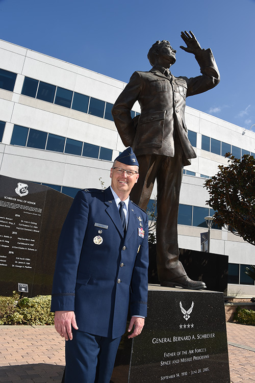
Col. Steve Whitney stands beside a statue of General Schriever at Los Angeles Air Force Base, home of the GPS Directorate. (Photo: U.S. Air Force/Joseph Juarez, Sr.)
By Col. Steven Whitney Director, Global Positioning Systems Directorate
The most discussed theme in the U.S. Air Force space community over the last year has been “resiliency.” But what does that actually mean, and how can the Air Force increase resiliency in space?
The GPS Directorate took these questions to heart and thought long and hard about resiliency in our Positioning, Navigation, and Timing (PNT) service. I am pleased to report that we have made significant progress in the past year in our quest to bring a new generation of PNT technology to reality.
More importantly, our investments in space, ground, and user equipment developments are bringing real, tangible benefits towards providing a more resilient PNT service worldwide. We stand on the cusp of delivering modernized civil and military GPS signals which provide critical pieces to the puzzle.
Farther into the future, the Air Force is already exploring new, emerging technologies and capabilities to even further advance the robustness of the GPS enterprise, with the vision that GPS will always remain the “Gold Standard” for the worldwide PNT community.
Resiliency Begins with Signals
Modernized GPS signals will be the first piece of the puzzle for an overall resilient PNT solution. The community has long anticipated the beginning of the multi-GNSS era.
The GPS Directorate has embraced this future with a new L1C signal, designed cooperatively from the ground up to be interoperable with international satellite navigation systems. The signal design will greatly improve GPS reception in cities and other challenging environments.
Another important GPS signal was introduced with our GPS IIF satellites. The L5 signal is designed specifically to meet the demanding requirements for safety-of-life transportation and other high-performance applications.
This signal is broadcast in a radio-frequency band reserved exclusively for aviation safety services to ensure it has optimal spectrum protection. Together, these two new additions greater improve PNT resilience for civil users around the globe.
“The need to improve cyber security and protection quite honestly cannot wait until delivery of the Next-Generation Operational Control System (OCX). To that end, the Directorate has focused on high payoff updates for the existing operational system.”
Other measures already improve resiliency by leveraging existing signals. For example, the L2C signal, when combined with L1 C/A in a dual-frequency receiver, will enable ionospheric error correction and improve positioning and timing accuracy.
For the military, the directorate has been focused on bring Military Code (M-code) into operations. The M-code signal features advanced anti-jam, anti-spoof, and encryption features that will ensure resilient and dependable PNT solutions for the United States and its allies.
The rollout of an operational M-code capability involves all segments of the GPS enterprise, and while it has been a long time in coming, the GPS Directorate made big strides this year (see “2017 in Review”). I will touch on the progress we are making in each of our development programs.
Resiliency in Space
The GPS space segment is the next step towards a more resilient PNT architecture. Our constellation remains robust and healthy, albeit aging, with 31 operational satellites providing worldwide coverage at the time of this article. The GPS III satellites will bring additional robustness with increased power and accuracy over previous generations of satellites.
We made big strides towards launching the first GPS III satellite in 2018, and just as importantly, production is in full swing on the rest of the ten satellites. I am incredibly proud of the entire government and contractor team that is meticulously acquiring, assembling, and testing these complex machines.
GPS IIIF. Farther into the future, the directorate is preparing for the GPS III follow-on program. The Air Force will be adding important new resiliency capabilities, with added signal flexibility via a reprogrammable, digital payload and increased anti-jam support to theater with a Regional Military Protection capability. Over the coming years as the follow-on GPS III satellites join the constellation, they will revolutionize GNSS with the full complement of operational L1C, L2C, L5 and M-code signals.
Resiliency in Control Segment
As important as the satellites are, the control segment is just as integral to the overall resiliency of the GPS enterprise. The need to improve cyber security and protection quite honestly cannot wait until delivery of the Next-Generation Operational Control System (OCX).
To that end, the directorate has focused on high payoff updates for the existing operational system.
For example, we acquired and deployed software-based GPS monitor station receivers, known as Monitor Station Technology Improvement and Capability (MSTIC) receivers, to replace the aging fleet of existing monitor-station receivers.
The functionality and expandability of the MSTIC receiver design will facilitate adding further capabilities such as M-code signal monitoring, and even civil L1C, L2C, and L5 signal monitoring.
The GPS Directorate also deployed a new cybersecurity monitoring suite to enhance cyber defenses. This new suite is in operation today at the GPS Master Control Station (MCS).
Beyond just improving our cyber protection, the Air Force has also stepped out on several OCX off-ramps to support the launch and operation of the GPS III satellites and mitigate risk of further OCX delays.
The Contingency Operations (COps) program modifies the existing Operational Control System (OCS) to allow the first GPS III satellites to join the operational constellation. The Air Force also initiated a companion program, M-code Early Use (MCEU) to further update OCS to provide limited M-code operations.
Together, these two programs provide critical interim steps towards fielding a more resilient constellation.
The OCX program provides the ultimate cyber protection and assurance needed for the GPS enterprise. After emerging from program recertification this year, the program has focused heavily on improved software system engineering and embracing software industry best practices, such as adopting DevOps and greater software automation.
The program has even leveraged Amazon Web Services’ Gov’t Cloud capability to provide more responsive development and test environments. While the program has a long ways to go, the government and prime contractor, Raytheon, are committed to delivery to ensure a robust and secure ground infrastructure.
User Equipment: Final Piece
The final piece of the resiliency puzzle for military customers is our user equipment segment. The directorate has made big strides in delivering the first set of modernized receiver cards for the Military GPS User Equipment (MGUE) Increment 1 program.
These advanced cards will enable platforms across the U.S. Department of Defense to leverage the new M-code signal, providing a tremendous boost in both anti-jam and anti-spoof capability.
They will also provide the latest in cryptography to ensure secure, robust protection for the United States and its allies.
Down the road, the Department of Defense is evaluating additional capabilities and platforms for the MGUE Increment 2 program.
Currently envisioned to address precision guided munitions, space receivers, and a modernized handheld unit, the Increment 2 program will be laying out an acquisition plan in this coming year to further adoption of M-code signals throughout the military.
A consideration for the future of user equipment will be exploring processing multi-GNSS signals. While no decisions have been made, multi-GNSS could offer opportunities for even additional resiliency.
Final Thoughts
This is an exciting time for the GPS enterprise.
We stand on the cusp of a new generation of capabilities that will usher in a huge increase in PNT resiliency and robustness. I am astounded at the quality of work that is presented at the many GNSS and PNT conferences around the world, and it is both exciting and humbling to see the community continuing to innovate ways to increase accuracy, integrity, availability, continuity, and performance.
Likewise, I am honored to lead the men and women of the GPS Directorate as we strive to deliver on our commitments and find new, innovative ways to provide robust and resilient PNT to the world.
This dedicated team is poised and ready to lead us into the future, and we look forward to working with the entire community to continue delivering the GPS “Gold Standard” in space-based PNT.
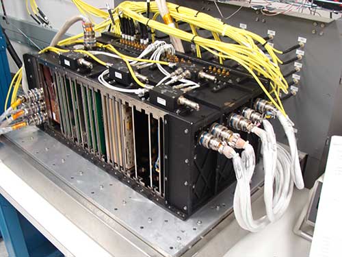
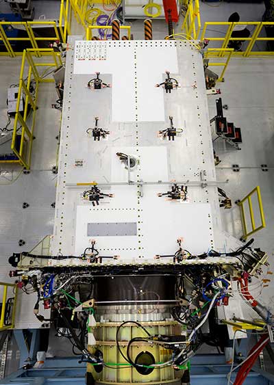
The fully digital Mission Data Unit (MDU) will create precise civil and military timing navigation signals for GPS III satellites 11 and beyond. Pictured here is the advanced MDU on navigation payloads being delivered for GPS III Space Vehicles 1-10. (Photo: Harris)
Harris Corporation has completed development of its fully digital Mission Data Unit (MDU), which is at the heart of its navigation payload for Lockheed Martin’s GPS III satellites 11 and beyond.
Harris has already provided MDUs and payloads for the first 10 GPS III satellites, one of which has been declared “available for launch” and the second of which is completing its testing. The other eight are in various stages of production assembly.
Payloads for the satellites 11 and beyond bring further signal transmit capabilities, providing more powerful signals and built-in flexibility to adapt to advances in GPS technology, as well as future changes in mission needs.
The new MDU that will eventually go aboard satellites 11+ “can be upgraded incrementally over its mission life due to built-in adaptability,” according to a Harris spokesperson.
GPS OCX
The U.S. Air Force Space and Missile Systems Center has accepted delivery of the GPS Next Generation Operational Control System (GPS OCX) Launch and Checkout System (LCS) baseline from Raytheon Intelligence and Information Systems. Also known as Block 0, LCS demonstrated conformance through test and analysis with all contractual requirements. OCX Block 0 is the foundation for Raytheon’s future Block 1 and 2 delivery, slated for 2022.
LCS is a fully modernized cyber-secure ground system complete with the computing hardware, operations center workstations, and mission application software necessary to launch the first GPS III satellite into orbit and perform initial on-orbit testing.
Mission operators are now using LCS in the GPS III Mission Readiness Campaign. The ground system is performing as expected during the rehearsals and space vehicle checkout.
Galileo Launch
A Galileo satellite undergoes its fit-check validation at the Spaceport. Flight VA240. (Photo: ESA/Arianespace)
As this magazine goes to press, final preparations are underway for Galileo’s quadruple launch on Dec. 12. The Ariane 5 rocket has completed its build-up at the spaceport in French Guiana and is moving toward payload integration and rollout to the launch zone.
The four 700-kilo (1,543-pound) Full Operational Capability (FOC) Galileo satellites have completed checkout and one-by-one verification of their interfaces with the payload dispenser that will release them once aloft in mid-Earth orbit.
They will soon take on fuel for their long space life.
The satellites will bring the Galileo operating constellation to 22, and, according to the European Space Agency, this will provide availability to users anywhere in the world for a high-quality position solution — defined as position dilution of precision (PDOP) less than 5 — 99.8% of the time.
The Ariane 5 for Arianespace’s Dec. 12 year-ending flight for 2017 has completed its initial build-up at the Spaceport in French Guiana — where preparations also are moving ahead with four satellite passengers that will further expand Europe’s Galileo global navigation system once in their final orbit.
During activity in the Spaceport’s Launcher Integration Building, the heavy-lift vehicle for Arianespace Flight VA240 underwent the assembly process that began by mating its two solid propellant strap-on boosters with the main cryogenic stage.
The next step was integration of Ariane 5’s vehicle equipment bay, which serves as the launch vehicle’s “brain,” providing autonomous control during the various mission phases.
It was followed by installation of the EPS storable propellant stage, powered by a reignitable engine that operates with MMH and N2O4 propellants. This differentiates the Ariane 5 ES configuration from Arianespace’s Ariane 5 ECA version, which has a cryogenic upper stage and typically is used on Arianespace missions with telecommunications satellites to geostationary transfer orbits.
Inside the Spaceport’s Launcher Integration Building, Ariane 5’s vehicle equipment bay is lowered atop the core cryogenic stage on Flight VA240’s Ariane 5 ES launcher version (left and center). This cleared the way for installation of the launch vehicle’s EPS storable propellant upper stage (right). (Photo: Arianespace)
After completion of verifications and systems checkout by production prime contractor ArianeGroup, the Ariane 5 ES launch vehicle will be moved to the Spaceport’s Final Assembly Building for payload integration and readiness for rollout to the launch zone.
The mission’s ongoing payload preparations — including checkout and fit-check procedure for each of the four Galileo satellites — took place inside the Spaceport’s S1A processing facility. This involved a one-by-one verification of the spacecraft’s interface with the payload dispenser that will release them into circular orbit during the mission.
After the fit-check procedure in the S1A facility, the four satellites were readied for transfer to the S5 payload preparation center for fueling.
For Ariane 5’s Dec. 12 mission, the heavy-lift vehicle will carry its quartet of Galileo satellites (weighing 700 kg. each) and their dispenser system for a medium-Earth orbit deployment.
A Galileo satellite undergoes its fit-check validation at the Spaceport. Flight VA240. (Photo: Arianespace)
Galileo is the European initiative to develop a global satellite navigation system. Under civilian control, it will offer a guaranteed, high-precision positioning service. As a European Union-funded program, the Galileo constellation will comprise 24 operational satellites, along with spares.
Overall responsibility for Galileo’s management and implementation is held by the European Commission, with the European Space Agency assigned design and development of the new generation of systems and infrastructure.
Ariane 5’s mission with the four Galileo spacecraft will close out a busy year of launch activity for Arianespace, which has performed 10 missions from French Guiana so far in 2017 — all of which were successful. The flights to date involved five launches of the heavy-lift Ariane 5, two with the medium Soyuz and three with the lightweight Vega.
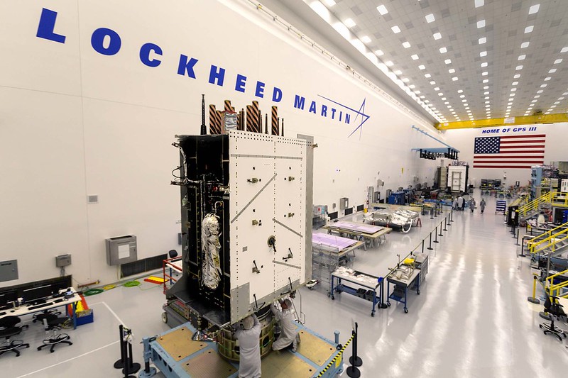
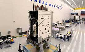
The U.S. Air Force’s third GPS III satellite in production flow at Lockheed Martin’s advanced satellite manufacturing facility in Denver is now fully integrated into a complete space vehicle.
GPS III Space Vehicle 03 (GPS III SV03) followed the first two GPS III satellites on a streamlined assembly and test production line. Technicians successfully integrated the satellite’s major components — its system module, navigation payload and propulsion core — into one fully assembled space vehicle on Aug. 14.
GPS III SV03 was assembled in Lockheed Martin’s GPS III Processing Facility, a $128 million, cleanroom factory designed in a virtual reality environment to drive efficiency and reduce costs in satellite production. Now fully assembled, the third satellite is being prepared to begin environmental testing.
GPS III SV03 is scheduled to launch on June 30. (Photo: Lockheed Martin)
GPS III SV03 closely follows the company’s second satellite in production flow. GPS III SV02 completed integration in May, finished acoustic testing in July and moved into thermal vacuum testing in August. The second GPS III satellite is expected to be delivered to the U.S. Air Force in 2018.
The fourth GPS III satellite is close behind the third. Lockheed Martin received the navigation payload for GPS III SV04 in October and the payload is now integrated with the space vehicle. The satellite is expected to be integrated into a complete space vehicle in January 2018.
In August, Lockheed Martin technicians began major assembly work on GPS III SV05.
All of these satellites are following Lockheed Martin’s first GPS III satellite, GPS III SV01, through production flow. In September, the Air Force accepted and declared GPS III SV01 “available for launch,” with launch expected in 2018.
“GPS III is the most powerful and complex GPS satellite ever designed and built, and it’s now into a smooth production flow,” said Mark Stewart, Lockheed Martin’s vice president for navigation systems. “The real credit goes to the Air Force for all the Back to Basics work done in advance, reducing program risk for all the GPS III satellites going forward. We are looking forward to bringing GPS III’s advanced capabilities to our warfighters in 2018.”
Lockheed Martin is under contract for 10 next-generation GPS III satellites as part of the Air Force’s modernized GPS. GPS III will have three times better accuracy and up to eight times improved anti-jamming capabilities. Spacecraft life will extend to 15 years, 25 percent longer than the newest GPS satellites on-orbit today. GPS III’s new L1C civil signal also will make it the first GPS satellite to be interoperable with other international global navigation satellite systems.
Lockheed Martin’s unique GPS III satellite design includes a flexible, modular architecture that allows for the insertion of new technology as it becomes available in the future or if the Air Force’s mission needs change. Satellites based off this design are already proven compatible with both the Air Force’s next generation Operational Control System (OCX) and the existing GPS constellation.
The GPS III team is led by the GPS Directorate at the U.S. Air Force Space and Missile Systems Center. Air Force Space Command’s 2nd Space Operations Squadron (2SOPS), based at Schriever Air Force Base, Colorado, manages and operates the GPS constellation for both civil and military users.
We just went to press with the December issue of GPS World magazine, its cover story consisting of personal essays from the directing officers and architects of each global satnav system.
You’ll have to wait for your copy to arrive in the mail or the digital edition to land in your inbox to read those articles in full, but I’ll give you a sneak preview here — just enough to springboard my hypothesis that, yes, system operators build great systems, but they are still subject to the whims of their national governments.
And those governments are operating on increasingly divergent agendas that will bring consequences upon the respective GNSS industries.
The plots of the four articles by the effective CEOs of each GNSS are the same: what innovations were accomplished in 2017, and what new features to look for in 2018. But the themes differ. If you reflect at the end of each article, try to read between the lines, divine what message seems most important to the author — then distinctions surface.
In our December pages we hear from:
Col. Steve Whitney
Col. Steven Whitney, Director, Global Positioning Systems Directorate:
“The Air Force is already exploring new, emerging technologies and capabilities to even further advance the robustness of the GPS enterprise, with the vision that GPS will always remain the Gold Standard for the worldwide PNT community.”
Sergey Karutin, GLONASS designer general; Nicolay Testoedov, Director General, SC Information Satellite Systems; and Andrey Tulin, Director General, SC Russian Space Systems:
“The traditional GLONASS conception of signal-in-space accuracy is now being augmented by the user level performance estimation. Due to the fact that the signal propagation environment contributes a lot to the positioning error budget, it is obvious that users need information that would reduce the influence of signal propagation path on the positioning accuracy.”
From left: Sergey Karutin, Nicolay Testoedov and Andrey TulinPaul Verhoef
Paul Verhoef, Director of the Galileo Programme and Navigation-related Activities, European Space Agency:
“The world of mobile-device LBS is going to change in 2018, and it will be due to the availability of Galileo. It will not be the first time the partnership of ESA, the European Commission (EC) and the GSA has made a service available that has changed the nature of the marketplace. “
Changfeng Yang, Chief Architect of BeiDou Navigation Satellite System:
“BDS-related products have gained access to the markets of more than 70 countries and regions, more than 30 of which are along the (land-based) Belt and (maritime) Road (in line with the Belt and Road Initiative). Through joint applications with other compatible navigation satellite systems, BDS provides global users with diversified choices for better application experience.”
Changfeng Yang
I’m not suggesting that the directors of each satnav system are trying to accomplish different things. All share the goal of providing the highest quality product and service. I posit that the hands above these guiding hands, atop the top — that is, the national governments paying for each system and directing the directors — do indeed have different priorities. Accuracy is not all that matters on the international scene, taken as a whole. Sound economies, vigorous markets, vibrant technologies, tradeable-upon intellectual property and highly trained corps of engineers all count for as much.
The respective governments’ priorities, which encompass much more than GNSS but surely have an effect upon it, may produce differing results for industry, markets and users. In that light I would bring to your attention a November 14 op-ed column by Thomas Friedman in the New York Times. I’ll return to this in a moment.
The most marked contrast in the “theme” or GNSS subtext of our December essays appears between the United States on the one hand and Europe and China on the other.
GPS appears focused on maintaining the Gold Standard of signals and on beefing up security, particularly for the military. Innovations such as the L2C signal, drawn up with significant if not predominant civil-sector input, will bring important growth and expansion of capabilities. But aside from that, it appears that industry can be left to itself to take care of innovation once the space signal hits the Earth’s surface.
GLONASS communicates a desire to burnish its reputation for accuracy and relevance. Once pre-eminently second among GNSS, it need to bootstrap itself back into competition to secure its increasingly tenuous toeholds in foreign markets.
Galileo and BeiDou project clear messages of working closely with industry sectors to encourage and intensify use. For the governments of Europe and China, GNSS is an economic tool, not merely a political one.
Now for Friedman’s thoughts on the international scene, quickly excerpted in their most relevant glimpses on the GNSS landscape:
“We’re going through a change in the “climate” of globalization: from an interconnected world to an interdependent one; from a world of walls, where you build your wealth by hoarding resources, to a world of webs, where you thrive by connecting your citizens to the most flows of ideas, trade, innovation and education.”
[….]
“In response to a more interdependent world, China is deepening its trade ties to all the fast-growing Asian markets around it through its “One Belt, One Road” project.”
[….]
“China has embarked on a plan called “Made in China 2025” that’s plowing government funds and research into commercializing 10 strategic industries while creating regulations and swiping intellectual property from abroad to make them all grow faster. These industries include electric vehicles, new materials, artificial intelligence, integrated circuits, biopharmacy, quantum computing, 5G mobile communications, and robotics.”
The European Union is actively and aggressively pursuing many projects and mandates similar to those underway in China.
The U.S., not so much. Not even near. In an environment in which it currently imports engineers to fill yawning vacancies in its high-tech work force, how long before it is reduced to importing technology as well, and at what cost?
Hope to See You There. In early of 2018, I will attend both events below, and look forward to talking with as many readers as possible at each event.
Join a full day of expert presentations and discussions on the opportunities and challenges (technical, commercial, ethical and legal) associated with developing fully autonomous systems that are cognizant and trustworthy for safety-critical applications. Free; sponsored by the Institute of Navigation. Speakers from the National Science Foundation, Department of Transportation, Air Force Research Laboratory, Top Flight Technologies, University of California-Santa Barbara, Santa Clara University, The Ohio State University and more.
This three-day international conference focuses on the latest developments in satellite-based navigation, gathering high-ranking speakers from industry, science and governments for a broad overview and differing perspectives. Topics include status and real-world results of Galileo; modernization of GPS, GLONASS and BeiDou; developments of QZSS and NavIC; the need for GNSS authentication; civil use of Galileo Public Regulated Service; legal aspects of GNSS; and autonomy within a single GNSS — still possible?
Presentations from the 20th meeting of the National Space-Based Positioning, Navigation, and Timing Advisory Board (PNTAB), held Nov. 15-16, are now available online at GPS.gov.
Ligado and its predecessors have sought to install high-powered ground transmitters that have been shown to harm and overwhelm GPS signals and receivers in their general vicinity. The controversy has simmered for at least eight years without resolution.
PNTAB provides independent advice to the U.S. government on GPS-related policy, planning, program management, and funding profiles in relation to the current state of national and international satellite navigation services.
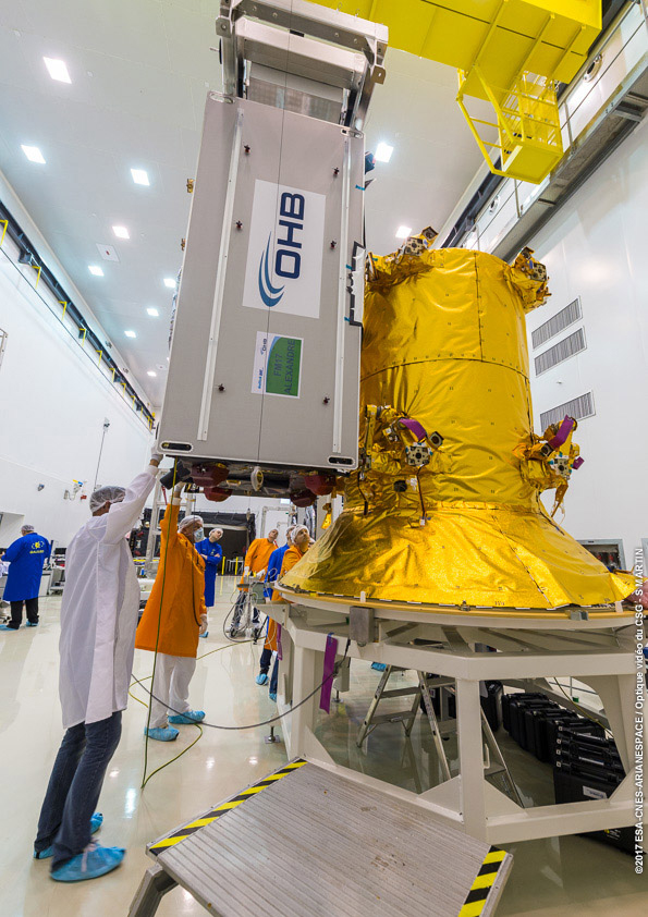
Three of the four Galileo satellites 19-22 undergoing fit check with the dispenser that will support them during their Dec. 12 flight into orbit. (Photo: ESA)
Europe’s next four Galileo navigation satellites and the Ariane 5 rocket due to lift them into orbit are being readied for their Dec. 12 launch from Europe’s Spaceport in Kourou, French Guiana.
On Nov. 21, Galileo satellites 19–22 were declared ready for flight, along with their Ariane. Combined activities are now under way, culminating in the satellites meeting their rocket in the Final Assembly Building.
The satellites were flown in pairs to French Guiana last month. Once safely unboxed in the Spaceport’s cleanroom environment, they were tested to ensure they had suffered no damage during their transatlantic flights.
The four Galileo satellites mounted on top of a customised Ariane 5 rocket inside the aerodynamic fairing. (Image: ESA)
Next came their fit check, when they were mechanically and electrically linked one by one to the dispenser that will carry them during their ascent to the target 23,500 km-altitude orbit, before releasing them into space.
Last Friday saw the satellites filled with enough fuel to fine-tune their orbits and orientation during their projected 12-year working lives. Next, they will be attached to their dispenser together for the final time.
In parallel, their customised Ariane 5 is being assembled. Two solid-propellant boosters were mated with its main cryogenic stage before the addition of the interstage that carries the electronics to control the vehicle.
Next came the addition of the storable propellant stage, powered by a reignitable engine, which will deliver the quartet to their target orbit.
Once fully checked, the Ariane will be moved to the final building for the addition of the satellites atop their dispenser, sealed within their protective fairing.
This launch will bring the total Galileo constellation to 22, boosting the global availability of navigation signals. Galileo began Initial Services just under a year ago, the first step before full operations, on Dec. 15.
Galileo’s Ariane 5’s vehicle equipment bay is lowered for installation within the Final Assembly Building of Europe’s Spaceport in French Guiana. Flight VA240 carrying Galileo satellites 19–22 into orbit is scheduled for Dec. 12. (Photo: ESA)
Harris Corporation has completed development of its fully digital Mission Data Unit (MDU), which is at the heart of its navigation payload for Lockheed Martin’s GPS III satellites 11 and beyond.
The current Harris payload for GPS III space vehicles (SVs) 1-10 includes a greater than three times reduction in range error, up to eight times increase in anti-jamming power, added signals — including one compatible with other Global Navigation Satellite Systems (GNSS) — and greater signal integrity.
The fully digital Mission Data Unit (MDU) will create precise civil and military timing navigation signals for GPS III satellites 11 and beyond. Pictured here is the advanced MDU on navigation payloads being delivered for GPS III Space Vehicles 1-10. (Photo: Harris)
Harris’ GPS III SV11+ fully digital navigation payload will further improve on performance for the U.S. Air Force by providing more powerful signals, plus built-in flexibility to adapt to advances in GPS technology, as well as future changes in mission needs.
“This design is fully mature — an Engineering Development Model, not a prototype — and is ready to be inserted into GPS III SV11+,” said Bill Gattle, president, Harris Space and Intelligence Systems. “The payload has the flexibility to serve the warfighter over the entire mission life and can be upgraded incrementally over its mission life due to built-in adaptability.”
Harris navigation payloads are already integrated in the second GPS III space vehicle, pictured here, and the first GPS III satellite, declared available to launch in 2018. (Photo: Lockheed Martin)
The payload design also ensures flawless atomic clock operations, providing the reliable GPS signal that millions of people — including U.S. soldiers — and billions of dollars in commerce depend on every day, the company said. It also will provide the clock signal for a new GPS III Search and Rescue (SAR) payload.
Beyond flexibility and reliability, the new Harris SV11+ navigation payload offers a smooth transition to the Air Force’s GPS OCX ground control segment. The Harris payload for the first ten GPS III satellites already has been verified for OCX compatibility, and this will allow Harris to seamlessly port the Harris SV11+ design, minimizing integration risks and associated costs.
China successfully launched a new pair of BeiDou navigation satellites on Sunday, Nov. 5, reports NASAspaceflight.com.
Beidou-3M1 (Beidou-24) and Beidou-3M2 (Beidou-25) went aloft aboard a Long March-3B/YZ-1 rocket at around 11:45 UTC from the LC2 Launch Complex of the Xichang Satellite Launch Center, Sichuan province.
The launch, previously scheduled for July, was delayed until now due to a partial launch failure with the previous launch of this rocket during the Zhongxing-9A (ChinaSat-9A) mission, which resulted in the satellite being lofted to a lower than planned orbit.
The satellites are using a new bus that features a phased array antenna for navigation signals and a laser retroreflector.
The Beidou Phase III system includes the migration of its civil Beidou 1 or B1 signal from 1561.098 MHz to a frequency centered at 1575.42 MHz — the same as the GPS L1 and Galileo E1 civil signals — and its transformation from a quadrature phase shift keying (QPSK) modulation to a multiplexed binary offset carrier (MBOC) modulation similar to the future GPS L1C and Galileo’s E1.
Sokkia’s Tammy Aalto gives GPS World a rundown on one of the company’s latest receiver, the GSX3, at Intergeo 2017 in Berlin, Germany. According to the company, improvements on this receiver include the addition of BeiDou and Galileo tracking capability, longer range base-to-rover communication, and performance in tree canopy situations.