The Department of Defense announced that U.S. Air Force Space Command will begin broadcasting Civil Navigation (CNAV) messages on all operational GPS satellites capable of transmitting the L2C and L5 signals. L2C and L5 are the first of several new civil capabilities being added to GPS as part of the GPS modernization program announced in 1999. The L2C signal is designed to meet commercial needs and L5 meets safety-of-life transportation requirements.
“We have been working in partnership with the U.S. Department of Transportation (USDOT) to enable early delivery of two more civilian frequencies from the GPS satellite constellation,” said Maj. Gen. Robert E. Wheeler, DoD deputy chief information officer, C4 and Information Infrastructure Capabilities. “These new CNAV messages will enable manufacturers to develop and test advanced civil receivers and make for a more robust Position, Navigation and Timing (PNT) solution available to the civilian public. We do not anticipate any GPS satellite outages or legacy degradations as a result of the pre-operational deployment of these frequencies, and those currently using the GPS Standard Positioning Service should not be impacted,” he added.
The implementation will take place in two phases. First, on April 28, 2014, the initial broadcast of CNAV message-populated L2C and L5 signals will occur at a reduced data accuracy and update frequency compared to the legacy GPS signals in wide use today. Second, in December 2014, CNAV data updates will increase to a daily rate, bringing L2C and L5 signal-in-space accuracy on par with the legacy signals. However, derived position accuracy cannot be guaranteed during the pre-operational deployment of the frequencies. These pre-operational signals are primarily used to test various equipment and should be employed at the users’ own risk; not used for safety-of-life or other critical purposes.
The Air Force will broadcast L2C messages with the health bit set “healthy,” as was the case during a June 2013 test. L5 messages will be set “unhealthy,” but as greater experience with the L5 broadcast and implementation of signal monitoring is achieved, this status may change upon review. The public will receive ample notification before any decision to set the L5 health bit to “healthy.”
“The U.S. Department of Transportation is pleased with the collaborative effort and work of the CNAV tiger team, formed between the Office of the Secretary of Defense, Air Force Space Command, and the U.S. Department of Transportation, to address concerns about implementation of a pre-operational CNAV capability on the GPS L2C and L5 signals,” said Greg Winfree, assistant secretary for research and technology at USDOT.
For additional information about the testing, contact the Air Force Space Command public affairs office at 719-554-3731.
The two April failures in Russia’s GLONASS were caused by mathematical mistakes in software, according to Oleg Ostapenko, head of the Russian space agency Roscosmos.
Russian newspaper Ria Novosti reported on a press conference where Ostapenko said that programmers who had designed the satellites’ new software had made several mathematical mistakes, but the problem was not major and has practically been solved. “There were some mathematical mistakes, but they have been corrected,” he said.
Ostapenko said that the remaining problems would be solved by mid-May, and there is almost no chance of a similar failure happening in the future.
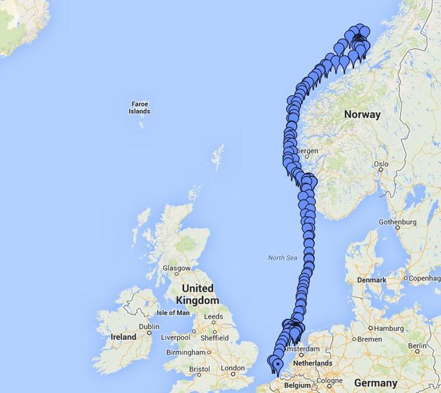
Belgian frigate Leopold I-F930 in rough water off Norway during Galileo maritime testing. In December 2013 the frigate participated in the first maritime trials outside mainland Europe of the Galileo satellite navigation system.
Results are being processed from the first Galileo maritime trials outside of mainland Europe. The long-range, high-latitude testing spanned the North Sea, following the same historical sailing route that Viking dragon-ships used 1200 years ago.
Ancient manuscripts record Viking navigators relied on “sunstones” to find their way — archaeologists believe these may have been polarizing crystals to pinpoint the Sun even in overcast skies.
By contrast, Belgian frigate Leopold I-F930, participating in the end-of-year trials, carried the most up-to-date equipment possible, with multiple Galileo receivers for both its public Open Service (OS) and secure Public Regulated Service (PRS).
“Galileo is in a transition between its In-Orbit Validation (IOV) phase and follow-on Full Operational Capability phase,” said Miguel Manteiga Bautista, head of ESA’s GNSS Security Office. “This means we are engaging in all kinds of experimental demonstrations of all Galileo services, in particular PRS, which offers the most highly accurate positioning and timing performance, but with access strictly restricted to authorized users.”
The recorded course of Belgian frigate Leopold I-F930 during the first high-latitude trials of Europe’s Galileo satellite navigation system. The frigate sailed first from the Dutch marine base of Den Helder on 4 December 2013 to Stavanger in Norway. From there it progressed north in very rough seas with 10-m high waves, coming close to the Arctic circle on December 17 — a first for Galileo PRS observations — before heading homeward.
The frigate sailed first from the Dutch marine base of Den Helder on December 4, 2013, to Stavanger in Norway. From there it progressed north in very rough seas with 10-meter-high waves, coming close to the Arctic circle on December 17 — a first for Galileo PRS observations — before heading home.
The testing provided tangible in-situ evidence of Galileo signal stability across both its operating frequencies up at high latitudes, equaling low satellite elevations in the local sky.
Following the completion of earlier road, then flight, testing last summer and autumn, the last challenge for Galileo’s IOV phase was to engage in a long-term maritime trial into high latitudes. The testing was performed as part of the PRS Participants to IOV project jointly managed by ESA and the European Commission, in collaboration with the European GNSS Office Agency and several Member States possessing PRS test receiver technology.
The trials were performed by the Royal Military Academy of the Belgian Ministry of Defence, the UK Space Agency in collaboration with Nottingham Scientific Ltd. and ESA, to ensure PRS signals were available whenever the four Galileo satellites in orbit came into view.
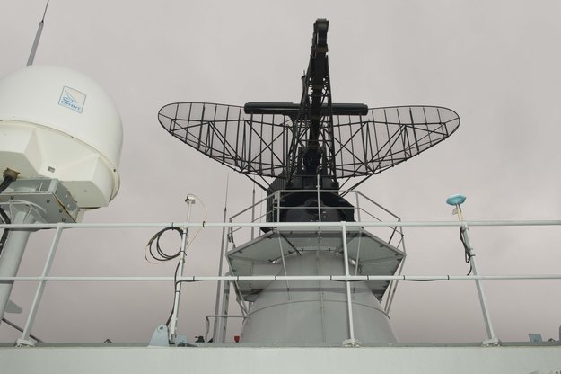
Two receivers, seen either side of the main antenna, were carried by Belgian frigate Leopold I-F930 during high-latitude testing of both Galileo’s publicly-available Open Service and secure Public Regulated Service in December 2013.
A dual-test setup was fitted to the frigate at Den Helder. Belgium connected a PRS receiver and an OS receiver, both manufactured in Belgium by Septentrio NV, to a common antenna. The PRS receiver recorded raw PRS measurements on both frequencies while the OS receiver logged data from openly available Galileo, GPS and GLONASS signals at one-second intervals.
Nottingham Scientific installed its Ultra system configured to record radio-frequency samples, allowing the detailed post-processing of Galileo OS and PRS signals.
“As this was a first use of PRS equipment outside EU borders, the security issues were quite challenging,” said Bruno Vermeire, head of the Belgium Competent PRS Authority (Federal Public Service of Foreign Affairs). “Several partners from different countries and industries were involved. At all times the necessary security was assured, though this could not have been possible without the dedicated joint commitment of all partners.”
David Parker, head of the UK Space Agency, commented, “This test is a significant milestone on the road to demonstrating early PRS capability across a range of platforms. It should serve as a model for wider international collaboration between national governments and industry to prove and demonstrate PRS in different applications.”
Belgian frigate Leopold I-F930 at Den Helder dockyard in the Netherlands.
Alain Muls, professor of the Royal Military Academy of Belgium, faced the challenge of coordinating the maritime trial without interfering with the normal operations of the frigate. “Thanks to the cooperation of with the Maritime Component of the Belgium Defence, in particular that of the frigate’s commander and crew, preliminary results look very promising. Reception of Galileo’s OS and PRS navigation services have been practically demonstrated under severe maritime conditions with waves of up to 10 meters in height.”
“This activity is a truly collaborative effort at all levels. The trial involved UK and Belgian governments and industry partners with support from different European bodies as well as officials from the Netherlands and Norway,” said Mark Dumville, Nottingham Scientific general manager. “This team effort has enabled the concept of radio-frequency sampling processing of Galileo PRS signals to be tested in real-world operational environments. We have confirmed that the prototype receiver is now ready to support European governments and associated PRS applications.”
The collaborative nature of this trial was formally recognized as the Leopold I-F930 reached Stavenger. Under the supervision of Belgium’s CPA, Jochen Devadder, the country’s Ambassador to Norway Michel Godfrind provided a Norwegian delegation with details of the testing.
Results from the trial will guide future Galileo developments for years to come.
U.S. Air Force Space Command will be implementing CNAV messages on the GPS L2C and L5 signals beginning April 28 at 14:30 UTC, to facilitate user familiarization and development of compatible user equipment. No GPS satellite outages or degradations are planned. The L2C and L5 CNAV messages should be transparent to users.
A 30-day public comment period on the pre-operational CNAV message ended April 4, apparently without enough concern to halt or delay the implementation.
These pre-operational signals may not comply with all requirements, and so shouldn’t be used for safety-of-life or other critical purposes, Air Force Space Command said.
Full text of the NANU appears below:
Subject: New NANU 2014038
NOTICE ADVISORY TO NAVSTAR USERS (NANU) 2014038 NANU TYPE: GENERAL
*** GENERAL MESSAGE TO ALL GPS USERS *** The purpose of this notification is to inform users of an upcoming event related to the GPS satellite constellation. Air Force Space Command will be implementing CNAV messages on the GPS L2C and L5 signals beginning J118/1430z with updates from the control segment approximately twice per week. The message populated signal content will include Broadcast Message Types (MT) 10, 11, 12, 30, and 33. There are no planned GPS satellite outages or degradations for this activity. L2C and L5 CNAV messages should be transparent to GPS receivers that do not process L2C or L5 CNAV messages. These populated signals are intended to facilitate user familiarization and development of compatible user equipment.
NOTE: Until further notice, the L2C and L5 signals are considered pre-operational. A pre-operational signal means the availability and other characteristics of the broadcast signal may not comply with all requirements of the relevant Interface Specifications and should be employed at the users’ own risk. Therefore these signals should not be used for safety-of-life or other critical purposes. Any military or civil users who encounter user equipment problems following message population of the L2C and L5 signals should contact the applicable POCs identified below as soon as possible. Aviation users should file reports consistent with FAA-approved procedures.
*** GENERAL MESSAGE TO ALL GPS USERS ***
POC: CIVILIAN – NAVCEN AT 703-313-5900, HTTP://WWW.NAVCEN.USCG.GOV
MILITARY – GPS OPERATIONS CENTER at HTTPS://GPS.AFSPC.AF.MIL/GPSOC, DSN 560-2541,
COMM 719-567-2541, [email protected], HTTPS://GPS.AFSPC.AF.MIL
MILITARY ALTERNATE – JOINT SPACE OPERATIONS CENTER, DSN 276-3514,
COMM 805-606-3514, [email protected]
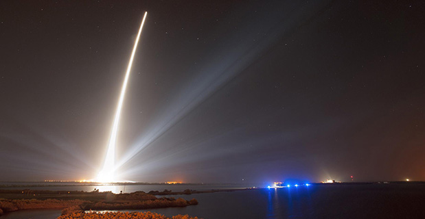
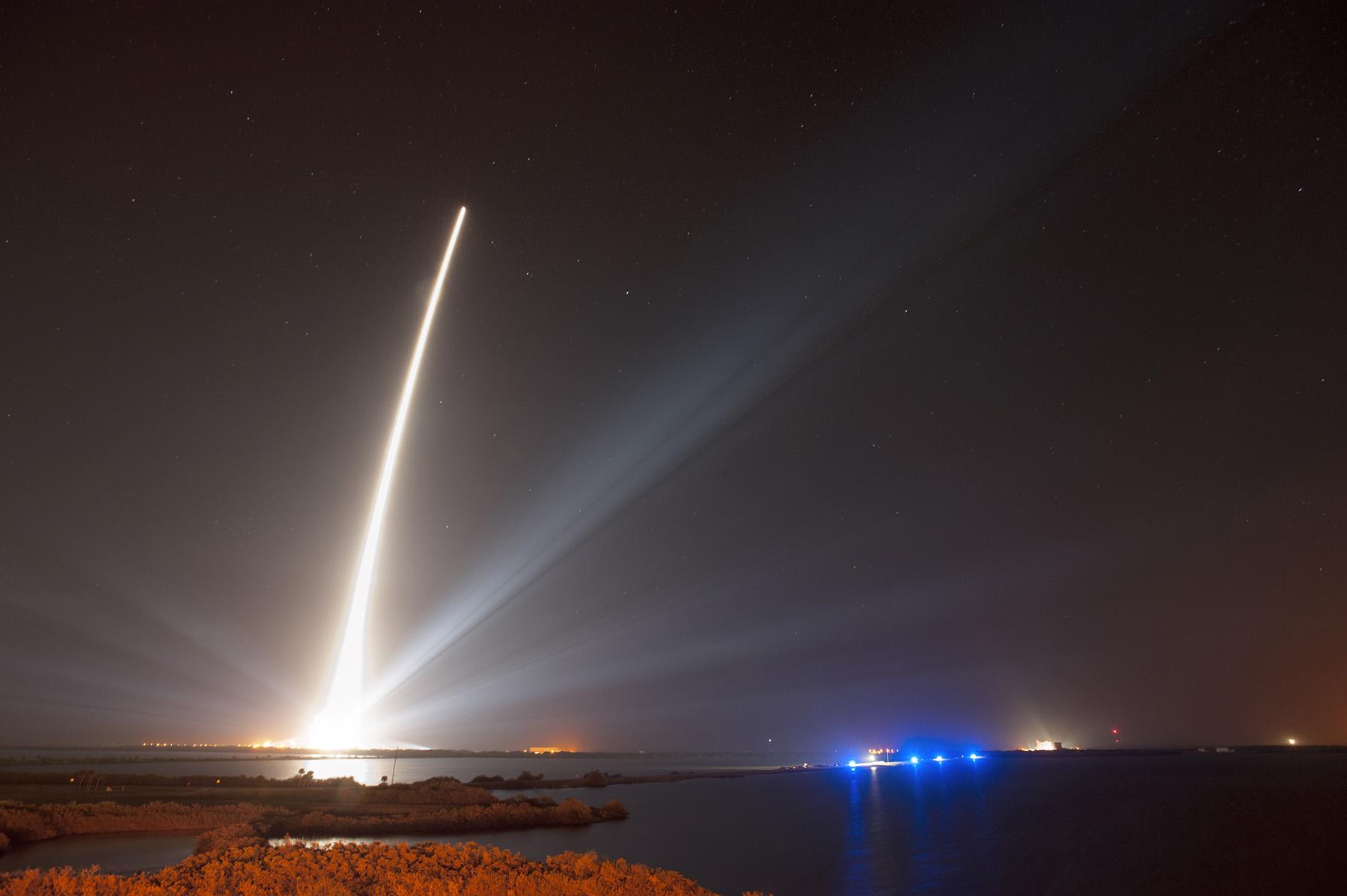
GPS IIF-5 was launched on February 20 and turned over to the 2nd Space Operations Squadron (2 SOPS) for operations on March 5. This was the 10th successful launch and initialization using Braxton Technologies‘ Launch, Anomaly Resolution, and Disposal Operations (LADO) system.
LADO has performed all the mission planning, commanding and telemetry processing necessary to prepare all GPS satellites for operational use since October 2007. Developed and sustained by Braxton Technologies, LADO was built using Braxton’s ACE Premier commercial-off-the-shelf (COTS) product line for spacecraft control, astrodynamics and simulation.
“Braxton is proud to be a key partner on the GPS program,” said Ken O’Neil, Braxton’s President and Chief Operating Officer. “As a small business, we greatly value our partnership with the US Air Force and enjoy quickly delivering innovative capabilities to support the U.S. military and the GPS worldwide user community.”
The GPS IIF-5 replaces the GPS IIA-15 satellite launched in 1994. The 19th Space Operations Squadron (19 SOPS) will control the GPS IIA-15 using LADO, where the spacecraft will be stored as a spare available for reactivation within the x-plane for the remainder of its useful life.
A United Launch Alliance Delta IV lifts off from Space Launch Complex-37 with the Air Force’s Global Positioning System (GPS) IIF-5 satellite. This launch marked the 25th Delta IV flight since the first flight in 2002.
The latest GPS Block IIF satellite, IIF-5 or SVN64 (operating as PRN30), was launched on February 21, 2014. Typically, GPS satellites are checked out and made operational within about a month following launch. SVN64 has yet to be set healthy.
The delay is due to an extended navigation test being performed by the GPS master control station. A navigation upload for SVN64 was performed in March with ephemeris and clock data as usual streching weeks in advance. However, unlike with operational satellites, no further updated uploads have been performed. The aging ephermis and clock data gradually becomes less and less accurate as time goes by but should degrade gracefully.
Inquisitive observers will have noticed that the received navigation data from SNV64 changes infrequently. Currently, the navigation data changes once per day with an epoch of 13:00 GPS Time unlike every two hours with operational satellites. And the data fit interval is 26 hours, compared to four hours.
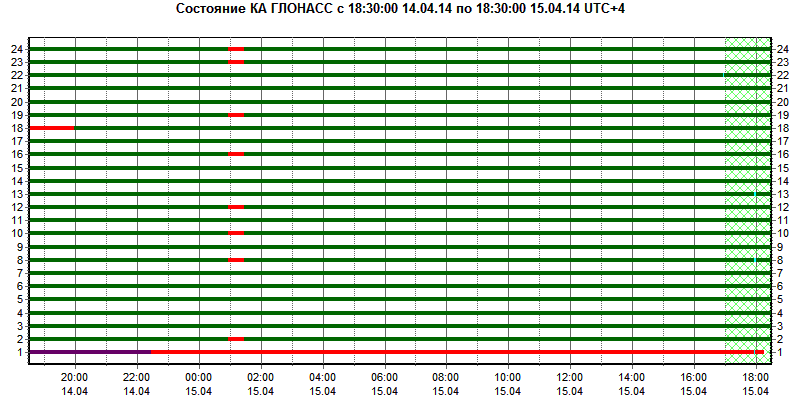
The GLONASS constellation has suffered a major problem for the second time this month.
On Monday, April 14, eight GLONASS satellites were simultaneously set unhealthy for about half an hour, meaning that most GLONASS or multi-constellation receivers would have ignored those satellites in positioning computations. In addition, one other satellite in the fleet was out of commission undergoing maintenance. This might have left too few healthy satellites to compute GLONASS-only receiver positions in some locations.
The unhealthy status of the satellites was noted in the monitoring information provided by the Roscosmos GLONASS Information-Analytical Centre website. The problem was also reported by The Moscow Times, an English-language daily published in Russia.
“What can we do to reduce the vulnerability [of GPS] and ensure that the expectations of the public are going to be met?” asked Dr. Bradford Parkinson as he opened his presentation this morning (Tuesday, April 15) at the European Navigation Conference, ENC-GNSS 2014 in Rotterdam, The Netherlands.
Parkinson went through his 61-slide, 50-minute briefing on what he called “PTA” — Protect, Toughen, and Augment — a proposal concerning not only GPS but PNT systems globally. An article by Parkinson based on this talk will highlight the special 25th Anniversary edition of GPS World, to appear in conjunction with this year’s July issue.
Brad Parkinson
After briefly overviewing the many worldwide applications of GPS and its penetration and participation in several vital markets, Parkinson stated “If we want to ensure the economic benefits of GPS, there are some essential needs that a user has. The first need is availability, and I’m defining availability in a certain way. It’s at the required accuracy for the application involved, and it has a bound on the random events that happen out there.
“The second required aspect is integrity, as in ‘I know I’m getting this accuracy, the system is not lying to me.’ In many cases, it’s required that the system not lie to you more often than once in 10 to the seventh (10 million) times.”
Parkinson developed his Protect, Toughen, and Augment proposal in part in response to a remark he heard from a high U.S. government official who opined that “GPS is much too vulnerable, we need to replace it.” While agreeing that the system is vulnerable, Parkinson has strived for a more constructive approach to the problem.
At the end of his presentation, Parkinson introduced one of his colleagues in the audience, from his early days on the GPS Program, and stated that if it was not for Hugo Fruehauf’s expertise with atomic reference systems in 1973, there might never have been a GPS program.
Parkinson was among attendees at an ENC event at City Hall hosted by the Mayor of Rotterdam, The Netherlands. From left are Hugo Fruehauf, Mrs. Bradford “Ginny” Parkinson, Professor Bradford Parkinson, Don Jewell — GPS World Defense Editor, Jac Spaans — Chairman of the Organizing Commitee of the ENC, and Adrianna Spaans.
Calling it an “unprecedented and deeply worrying total disruption . . . [that] shook the industry,” Locata Corporation reiterated its call for redundant terrestrial systems to back up GNSS in the wake of the April 1 11-hour GLONASS system outage.
Nunzio Gambale, Locata CEO, said “We have been telling the industry for years that you cannot have a critically important capability like GPS without also having a backup! What is Plan B if the satellite systems fail? What replaces the space signal when there is a problem? If anyone needed a sign to understand why Locata has spent years inventing and developing the world’s first local terrestrial equivalent of the GPS system, then last week’s meltdown of a complete global satellite navigation system is it. This event should terrify every nation, government, and company that depends on navigation satellites for their business or, in some cases, their very lives.”
The navigation and timing functions of the global positioning systems underpin the world’s banking systems, stock exchanges, digital TV and Internet, cell phone networks, and, in some cases, the national electricity supply, Locata pointed out. GPS, in particular, plays a crucial role in transportation, shipping, and logistics, serving as the enabling technology for critical functions like air traffic control. Reliability is therefore not just important; it is essential across all applications. Locata, the Resilient Navigation and Timing Foundation (RNTF) in Washington, D.C., and others have persistently called attention to the need for redundant terrestrial systems that will back up expensive, vulnerable, and aging global satellite navigation constellations while simultaneously providing the local control and resiliency that satellite-based systems cannot deliver.
Professor Chris Rizos of the School of Civil and Environmental Engineering at the University of New South Wales stated that “This catastrophic failure of one of the world’s two global satellite navigation constellations is a wakeup call for all of us. We ignore the possibility of these ‘Black Swan’ events at our own peril.”
The GLONASS disruption was felt around the world, immediately upon its origination, especially in professional applications, such as tractor automation for farming, machine control and robotics in mining and heavy industry, and in the national infrastructure used by surveyors and industry across many countries.
“This shows just how interlinked the physical and cyber worlds have now become,” added Professor Brett Biddington, a space and cybersecurity expert from the School of Computer and Security Science at Edith Cowan University, Australia. “The prospect of a software glitch, whether unintentional or intentional, seems highly likely [as a cause for the failure]. If it was a deliberate attack, however, it points to a changing face of warfare where the real enemy may be impossible to detect and deter until very damaging strikes, such as an attack on the GPS system, have already taken place.
“The vital point here is that this is no longer just a question for scientists and technologists. A locally controlled backup system for this essential signal is a national policy question of the highest order.”
Locata Corporation and other industry authorities have long testified on global satellite navigation vulnerabilities and the need for diverse technology options to strengthen and back up GPS, GLONASS, and other systems. Locata developed a robust solution and has been awarded a sole-source contract by the U.S. Air Force (USAF) to provide its terrestrially based alternative positioning for military applications where GPS has been completely jammed. The first wide-area Locata system is being deployed now at the White Sands Missile Range in New Mexico. The USAF demonstrated that the White Sands Locata network delivers what has been extremely high accuracy over a 2,500-square mile area, positioning aircraft flying up to 35 miles away to an accuracy of better than six inches.
A pair of LocataLite transmit antennas overlook a section of the White Sands Missile Range blanketed by the Locata high-precision ground-based positioning system.
“There is no other technology that can do this, and it’s delivered in the complete absence of GPS,” continued Gambale. “What is being demonstrated at White Sands is that Locata supplies precisely the same function as GPS, even when there is no GPS available. That’s exactly what you need if the satellites fail.
“If this event had been a GPS failure instead of a GLONASS failure – and it could very easily have been – then the entire world would have plunged into a catastrophe. This event is the navigation equivalent of a ‘close call moment,’ and from here on out no one can even question that this is a really serious problem that must be addressed. Another industry expert recently told me, ‘If there was a sustained GPS outage, it would cause a global financial nuclear winter from which it would take us decades to recover.’”
Gambale concluded, “We need action to develop local backups like Locata around places like airports and other strategically important areas – now! We must not wait until we are faced with another seemingly impossible event like a complete satellite constellation failure. We may not dodge this bullet a second time.”
Locata terrestrial positioning technologies complement GPS by setting up ground-based transmitters, called LocataLites, to create a local constellation called a LocataNet. Once properly deployed, Locata’s unique nanosecond-accurate TimeLoc system synchronizes the network, which allows it to replicate the positioning capabilities of GPS, locally. LocataNets operate today in environments ranging from small warehouses to open-cut mines, wide-area aircraft approach-and-landing systems, and wider areas for aircraft and unmanned aerial vehicle (UAV) uses.
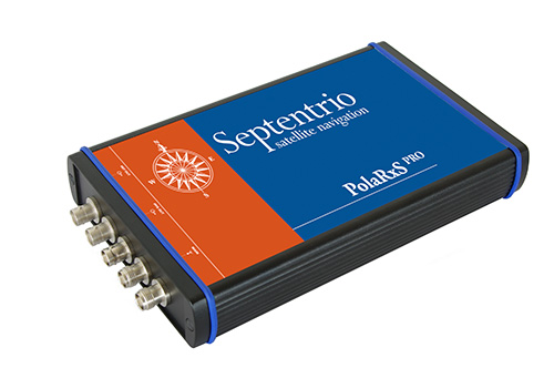
The PolaRxS by Septentrio is a multi-frequency, multi-constellation receiver dedicated to ionospheric monitoring and space weather applications. It features simultaneous high-quality tracking of all visible signals (L1, L2, L5, E5ab/AltBOC GPS/GLONASS/Galileo/Beidou/SBAS) at low noise levels. The receiver outputs an extensive set of GNSS measurements, including signal phase and intensity at up to 100 Hz, with a phase noise standard deviation (phi60) as low as 0.03 rad.
The A Posteriori Multipath Estimator (APME+) tackles short-delay multipath to enhance the measurement quality, while LOCK+ tracking guarantees robust tracking of rapid signal dynamics during scintillation events. Included tools provide continuous total electron content (TEC) and scintillation indices logging for space weather and ionosphere monitoring.
Learn about more Galileo-ready products in our Galileo Product Showcase from the April 2014 issue.
The transition to using the terrestrial geocentric coordinate system “Parametry Zemli 1990” (PZ-90.11) in operating GLONASS has been implemented, according to an April 4 announcement by the Russian Federal Space Agency’s Information-Anayltical Center.
The implementation fulfills Russian Government Resolution № 1463 of December 28, 2012, “On the Common National Geodetic Coordinate Systems,” outlining the transition starting at 3 p.m. on December 31, 2013. The fundamental geodetic constants as well as the Earth’s ellipsoid parameters used in PZ-90.11 are provided in the annex to the resolution.
The updated version of the GLONASS ICD (edition 5.1 of 2008) has been published.
Reports in the semi-official Russian news daily Izvestia indicate that finger-pointing has gotten underway regarding the April 1 GLONASS systemic blackout, which followed two other high-profile disasters, the destruction-upon-launch of three new GLONASS satellites in July 2013, and the Pacific drowning of three other satellites in December 2010.
While we have neither full nor fluent translations from the Russian, we have done the best we can, aided and abetted by Google, with the following passages.
“Temporary GLONASS failure has not led to tangible consequences for consumers of services for the reason that chip manufacturing exclusively GLONASS, the mass market is practically no: there are chips that work only with the signal GPS, and there are those that see both systems GPS and GLONASS.”
Clarification: there are practically no mass-market devices, even in Russia, that use exclusively GLONASS.
“In any case, the failure of the entire system for a long period a serious blow to the image of GLONASS, especially in a situation where Russia has made efforts to promote domestic navigation system to external markets. Plus in 2012, the Russian government officially promised to maintain the characteristics of the international community GLONASS at the proper level for 15 years.
“The following statement was distributed at the XII International Forum ICAO Air Navigation in Montreal by the Head of the non-governmental organization ‘Promoting the development and use of navigation technologies.’ Alexander Gurko believes that now GLONASS is not controlled properly, causing increased risks of such failures.
“There should be a system operator who is responsible for the quality of its operation, development and use, Gurko said. GLONASS still not officially put into operation, although it was promised two years ago and settled in many protocols, the Interagency Working Group. But it is still unclear who is responsible for the general quality of service.
“GLONASS system is not commissioned by the Ministry of Defence and officially still under development.
“Where to users with questions and explanations about the operation or development of the system? Asks questions Gourko. The Defense Ministry, Roscosmos? How are civil user requirements and market trends in the formation positioning system development plans?”
Izvestia further notes that in March of this year, the Russian government cut the GLONASS budget by 16 billion rubles ($450 million). “Signal quality and composition of the orbital constellation sequestration will not affect, say Roscosmos. It is important to reduce not touched the ground part, experts say.”