Withheld from the public for two years, since its completion in March 2007, the Independent Assessment Team (IAT) report has been let out of detention, just in time to counter recent efforts by the Obama administration, the Department of Homeland Security, and the U.S. Coast Guard to throttle the program. The IAT “unanimously recommends that the U.S. government complete the eLoran upgrade and commit to eLoran as the national backup to GPS for 20 years.” The IAT’s conclusion has long been informally known throughout the GPS industry, but the report’s release adds considerable weight, expertise, and specifics to a long, determined campaign to preserve the program.
Compiled by the Institute for Defense Analyses, the IAT report has been held back from public release since March 20, 2007, when it was completed and presented to the co-sponsoring Department of Transportation and Department of Homeland Security (DHS) Executive Committees. Its release now comes only after an extensive Freedom Of Information Act (FOIA) battle waged by industry representatives against the federal government.
The report asserts that “eLoran is the only cost-effective backup for national needs; it is completely interoperable with and independent of GPS, with different propagation and failure mechanisms. . . . It is a seamless backup, and its use will deter threats to U.S. national and economic security by disrupting (jamming) GPS reception.”
The IAT, chaired by Bradford Parkinson, founding program director for GPS, and assisted by other industry experts, evaluated all available or potential alternatives for a GPS backup. In particular, it examined the costs of the Loran system and a transition to a new, modernized enhanced or “eLoran.” It found eLoran’s infrastructure enhancements to be 70 percent complete, and the cost to complete its rollout less expensive than decommissioning the Loran system.
The two-year-old report finally arrives in public view, staking out direct opposition to recent comments made by the DHS that Loran termination will save $190 million over five years. Such claims failed to specify or include the decommissioning costs, or explore the operational savings available with modern eLoran transmitters. Senior DHS representatives have — unbelievably, but yes, it is true — claimed recently that it is not clear a GPS backup is needed, and have taken the time-honored route of recommending additional study.
The IAT report concludes that “eLoran be completed and retained as the national backup system for critical safety of life, national and economic security, and quality of life applications currently reliant on position, time, and/or frequency from GPS.” Its authors emphasize that “the U.S. government policy decision is needed to motivate users to equip.”
Lt. Col. David Goldstein, chief engineer for the GPS Wing, told the plenary session at the European Navigation Conference in Naples, Italy, that the Wing is experiencing some “out of family” measurements from the recently launched IIRM (20) satellite. This appears to corroborate some unofficial rumors that have circulated recently about problems with “legacy signals” from the satellite, that is, L1 and L2. The April 10 broadcast of the first L5 signal secured that frequency for the U.S. GPS program; since that signal contains no navigation message at present, it is presumably not affected by these problems.
Goldstein told the ENC opening session, Monday May 4, that the Air Force will not launch any further satellites until this issue is resolved. IIR(M) 21, the last of the IIR(M) series, is currently scheduled to rise sometime in August, with the first of the IIF generation to follow in late 2009 or early 2010.
Normally, a satellite is set healthy within 28 days of launch, after extensive testing, but this has not occurred with the satellite launched on March 24. The U.S. Air Force has formed a response team and is working “nearly round the clock” to resolve the problem, but according to Goldstein is not rushing the issue, seeking a thorough solution since the overall constellation is robust at 30 satellites.
“We are currently examining data from the satellite that is not consistent with data from the other IIR(M)s,” he stated, characterizing the variances as “measurements with larger than expected pseudorange errors that are elevation-dependent, and that we have not seen before. We have experimented with a few fixes and it looks very promising.”
He described the response team’s approach as making a “fishbone diagram” of all potential failure mechanisms, and working through them methodically. “We think we have identified the failure but it may be several more months before the analysis is complete, and the situation is fully resolved.”
Speaking to GPS World at the Munich Satellite Navigation Summit, Gunther Heinrichs, the head of business development at IFEN GmbH, describes capabilities and simulation projects taking place in the Galileo Test Environment.
The experimental operation phase of GATE has been completed successfully. Since August 2008 it is possible for companies and research institutes to book GATE for various experiments. It is planned to operate GATE at least until the full operational capability of Galileo.
The GATE test bed cornerstones are six ground transmitters, emitting the Galileo signals towards the GATE test area. Inside this test area, which is located in the region of Berchtesgaden (GER), adequate receiver terminals can receive these signals and perform Galileo based positioning and navigation.
The Lockheed Martin team developing GPS III, the next-generation GPS spacecraft, is progressing on-schedule, achieving key milestones in the Preliminary Design Review (PDR) phase with the U.S. Air Force, according to Lockheed Martin.
GPS III will improve position, navigation and timing services and provide advanced anti-jam capabilities yielding superior system security, accuracy and reliability. The first block of the new generation satellites, known as GPS IIIA, will deliver significant enhancements over current GPS space vehicles, including a new international civil signal (L1C), and increased M-Code anti-jam power with full earth coverage for military users.
GPS IIIA also incorporates an aggressive capability insertion program that lowers technology and integration risks associated with the capabilities planned for future GPS III satellites. The capability insertion program will ensure a graceful growth path, minimizing re-design of the GPS IIIA satellites that are necessary to reach the full set of GPS III warfighter capabilities in future increments.
“The joint government-industry team is off to a robust start validating our requirements for this important program,” said Lt. Col. Donald Frew, the U.S. Air Force GPS III program manager. “Our back-to-basics approach in the execution of GPS III is already yielding excellent results and we look forward to achieving a successful segment-level review in May.”
Lockheed Martin Space Systems (Newtown, Pennsylvania), along with industry partners ITT (Clifton, New Jersey) and General Dynamics (Gilbert, Arizona), have successfully completed 19 out of 71 PDRs for key GPS III spacecraft subsystems and assemblies. These include L-Band transmitters, antennas, solar arrays, power regulation unit, all attitude control assemblies, as well as the Tracking Telemetry and Command (TT&C) subsystem and all TT&C assemblies. This effort will culminate in an overall GPS III Segment PDR in May to ensure the preliminary design meets warfighter and civil requirements prior to advancing into the Critical Design Review phase.
“Our progress in the preliminary design review stage is the result of an integrated government-industry team focused on achieving operational excellence and mission success,” said Dave Podlesney, Lockheed Martin’s GPS III program director. “We look forward to completing a comprehensive and efficient PDR phase to ensure a seamless transition to the critical design review phase for the vitally important program.”
The team is working under a $1.4 billion Development and Production contract awarded in May 2008 by the Global Positioning Systems Wing, Space and Missile Systems Center, Los Angeles Air Force Base, California, to produce the first two GPS IIIA satellites, with first launch projected for 2014. The contract also includes options for up to 10 additional spacecraft.
The GPS constellation provides critical situational awareness and precision weapon guidance for the military and supports a wide range of civil, scientific and commercial functions — from air traffic control to the Internet — with precision location and timing information. Air Force Space Command’s 2nd Space Operations Squadron (2SOPS), based at Schriever Air Force Base, Colorado, manages and operates the GPS constellation for both civil and military users.
GMV, a supplier of satellite ground system software headquartered in Madrid,
Spain, with a significant role in Europe’s Galileo program, has announced
the appointment of Jesus Serrano as its new Chief Executive Officer (CEO).
Serrano, 48, replaces Luis Mayo in his position as the business group’s top
executive, reporting directly to the board.
With more than 20 years of experience through various management positions
at GMV, this Spanish native will continue to lead the multinational technology
group and expand their products and services to its customers throughout the
U.S., South America, Africa, Asia and Oceania.
AeroScout Inc. has unveiled a combination GPS and Wi-Fi asset management system that has been selected by the U.S. Air Force 309th Aerospace Maintenance and Regeneration Group (AMARG) for its 110 million-square-foot outdoor facility at the Davis-Monthan Air Force Base in Arizona.
The system includes battery-powered tags that use both GPS to determine location outdoors and Wi-Fi to transport asset location and other information over a customer’s network, according to AeroScout.
The large-scale deployment will initially include 1,000 AeroScout GPS Wi-Fi tags for essential support equipment. The 309th AMARG stores thousands of aircraft and aircraft parts at the outdoor facility at Davis-Monthan outside Tucson, Arizona. In addition to tracking the precise location of essential support equipment, the AerosScout system will provide automated inventory reports, the company said.
The system will leverage the facility’s existing Wi-Fi network and 42 access points with high-gain antennas, which are also used for data communication. Using AeroScout’s MobileView 4.0 software, staff will be able to search for, locate, and manage essential equipment, according to the company.
On October 28 GPS World survey and construction Editor Eric Gakstatter will be discussing the U.S. Department of Defense GPS Wing’s proposal to discontinue supporting Civil P(Y) semi-codeless on GPS L1 and L2 after December 31, 2020 — rendering a massive amount of high-precision GPS equipment obsolete. The webinar is hosted by GPS World and sponsored by Magellan GPS.
What You’ll Learn:
A discussion of the semi-codeless technique they are referring to.
Who’s affected.
Which receivers are affected.
How it might impact your organization.
What options you have if you own legacy dual-frequency GPS equipment.
Who Should Attend:
The seminar will be targeted to professionals in high-precision positioning:
Presented here is a lightly abridged version of the plenary address by the European Commission’s Head of Unit for Galileo, Paul Verhoef, at the ION GNSS conference in Savannah, Georgia, September 16.
After a brief Galileo snapshot of current status, I will proceed as requested with predictions of life in a multiple-GNSS world. We have secured an additional budget of €3.4 billion mainly for developing and launching the Galileo constellation, with the key objective of a full operational capability in 2013.
Here let me talk about our second test satellite, GIOVE-B, launched on April 27. This bird is healthy and flying according to its specifications, although I hear there was a small problem that caused the satellite to go into safe mode. The engineers are currently testing the signals and using the flight and mission data to fine-tune the last parameters for the manufacturing of the 30 satellites of the constellation.
In July the European Space Agency (ESA) launched the procurement for the Full Operational Capability (FOC). As of last week, we have a shortlist of eligible bidders for sector primes, and ESA will now start the second phase. The list will be published in the next few days. I would like to add that we have opened up this procurement internationally in accordance with the European Union’s (EU’s) World Trade Organization commitments, and with some exceptions for areas of the system that contain classified technologies. The net results will be that EU prime contractors will be able to ask for authority to use non-EU suppliers and subcontractors.
We foresee Galileo to become operational in 2013. In the mean time, the European Geostationary Navigation Overlay Service (EGNOS) will make up the first element of the European GNSS. Just to recall, EGNOS is the augmentation system improving the accuracy of GPS and warning users of possible outages. EGNOS currently covers Europe, but extensions are being considered.
EGNOS is in its final qualification stage. Its performance is excellent, within 100 percent availability recorded over about nine months now. The European Commission intends to contract a private operator to operate and maintain the system starting next spring. In parallel, certification for aviation use is under way with the target of end of 2009.Let me now turn to market issues that take us through the issue of a multi-constellation world.
In Europe the emphasis has been redirected from focusing on direct revenues for the potential operator toward the possibilities to boost business, research, and the markets for GNSS applications both in Europe and worldwide.
IP and Applications. With this new direction in mind, we are now working on two sectors: intellectual property and application issues.
Intellectual property policy is high on our work plan for later this year and next year, and an analysis advancing on impact of various options in this context. We seek a solution balancing in a fair manner three objectives:
fair treatment of industries, EU or non-EU,
reasonable return to taxpayers’ money, and
ensuring the timely and sufficient availability of Galileo user receivers and downstream services at FOC.
Against the results of a recent stakeholder consultation, we are pursuing a second closely market-related initiative, an Action Plan which spells out Europe’s objectives and plans to develop applications for GNSS.
This will not be a marketing strategy for the European GNSS, but a list of actions that the public sector should take to support the development. For example, promote interoperability of road tolling systems in the EU and facilitate receiver development.In one word, European satellite navigation programs are on track, and we are excited that we have left behind the stormy times, and we hope that we are going to sail in calmer waters in the future.
Spacescape Evolution
This brings me to the GNSS fortune-telling part, as requested.
There will be at least four global systems and at least a half a dozen regional systems in Europe, the Americas, and Asia.
How will this affect GNSS?
The end users have everything to gain. I like to believe those that say that Galileo — even at the paper stage eight years ago — was one of the catalysts for innovation in this sector. We will soon have four for the price of one in your next multi-constellation receiver.
The obvious effect is that new applications will emerge as ever-more robust PNT (positioning, navigation, and timing) data penetrates service packages ranging from logistics to law enforcement.
One cellphone maker summarized the situation for the manufacturers and end users as something between fantastic and awesome. The downstream industries are possibly the big winners, at least in the medium term, until the market reaches a saturation point and consolidation picks up pace.
What about us GNSS providers? What’s in it for us other than footing the bill?
Tougher Customer Requirements. We GNSS providers will need to think hard about things such as backward compatibility, trade-off management of conflicting requirements, manufacturer friendliness and, not least, listening to the users.
We should reduce the time-to-market for new products and ensure a comprehensive and global customer support. At some point soon we need to seriously address the issue of third-party liability.
Regulatory Work. GNSS providers believe that limited and carefully targeted regulation in satellite navigation is actually useful. Examples speak for themselves: public authorities in all four global GNSS nations have taken or plan to take regulatory measures affecting the use of GNSS. Examples: E-911 in the United States, E-112 and livestock transport in Europe, government use in China, and so on.
Competition. Let’s face it: however governmentally, non-commercially, or multilaterally we run our systems, I do believe in the human desire for fame and reward. Each of us will want to be at least that little bit ahead of our neighbor, whatever parameters are used. In that situation the customer will be the king and can shop around — at least if competition is not distorted with system-specific mandates, cartels, or the like.
Trade Policy. From international competition there is usually a short way to trade policy and disputes. While trade discussions are useful, I hope we can stay clear of disputes as much as possible, as they divert resources from “the main thing.” So far that has worked quite well, yet we may need to put more efforts into verifying whether the current trade regime is sufficient and the playing field is actually level.
Spectrum. Linked to all these developments are the various aspects of radio spectrum, some mentioned earlier today already.
There is the increasing compatibility challenge caused by scarce spectrum, shortcomings of the International Telecommunications Union (ITU) mechanism for GNSS, and the desirability of common center frequencies, wider bandwidth, and so on. In short, a lot of work ahead of us.
Cooperation. As you heard in my words, international cooperation will need to underpin this environment in order to ensure proper functioning of the systems.
Evolution of Policies
While the European Commission may be Programme Manager, it is the transport departments of the EU and its 27 member states that actually are behind Galileo. They have done this for specific purposes: they want to use it.
Our research, space, foreign policy, and, believe it or not, finance colleagues tend to push this cart with us — usually in the same direction. As Galileo gets closer to the operational capability, the interest of the other departments, institutions, and stakeholders in Galileo and GNSS in general is likely to increase.
It is here in the United States where you have accumulated the longest experiences in this field. As we have heard, transport and other non-military policies have started to weigh more in the management of GPS over the years.
GLONASS is also diversifying with a higher civilian content. Our colleagues in Asia are moving forward with civil applications of higher density.
I foresee two trends:
First, whatever the policy mix behind the various systems, we can observe today an element of GNSS patriotism, alive and kicking. We all want our own systems and for quite legitimate reasons. That trend is likely to continue for some time still in the form of states or groups of states deciding to build their own regional or even global systems or integrity networks. In this business, added security or sovereignty qualifies as return on investment just as well as service quality, new jobs, or straight cash.
This is not the only trend in town. And yes, there is a counter-current hatching in the United Nations International GNSS Committee (IGC). Already the conception years of this new forum have created somewhat the “we are in the same boat” atmosphere among GNSS providers.
The point is that the IGC is becoming the place for all the providers and users to discuss GNSS coordination issues across several sectors (the ITU, International Maritimie Organization [IMO], and International Civil Aviation Organization [ICAO] are sector- or issue-specific). We have already seen signs of reaching the limits of bilateral coordination, for example, regarding compatibility and interoperability in a multi-constellation world. Deliverables from the IGC so far are encouraging, and the forum helps in communication and transparency between the participants.
I would expect to see cooperation emerging among the providers in constellation and ground-segment management from a pure cost point of view. It is like owning a sports car; as the mileage accrues over the years, the talk shifts from tuning options to maintenance bills.
Conclusions
The evolution of GNSS is bound to foster new applications; the quantum leap in available satellites and services will give end users and manufacturers sizeable benefits. The GNSS providers will need to adapt to this new reality and volatility and have a vision of what it is we actually want to achieve. Considerable investments in security will be needed at different levels of the systems.
That said, where policies are concerned, we will probably be witnessing two conflicting trends: GNSS patriotism and multilateral action through the IGC.
In the GNSS provider states, the mix and evolution of the national policies guiding GNSS development varies considerably. The tendency is towards enlarging, however, the group of stakeholders (government or other) involved in policy-making towards more and more user sectors.
In any case, in Europe we finally believe that satellite navigation is facing a fabulous future: technology trends such as personal computing, mobile communications, and the Internet come to mind.
We need to turn this challenge into an opportunity. There are many global issues to which satellite navigation can bring a small but important contribution such as climate change, reduction of CO2, reduction of fuel consumption, search and rescue, and much more. Ladies and gentlemen, I would like to thank again our hosts for giving me the opportunity to present our intentions with this conference, and I thank you for your attention.
Northrop Grumman Corporation (Reston, Virginia) has completed the integrated baseline review for the U.S. Air Force Next-Generation Global Positioning System (GPS) Ground Control Segment (OCX), achieving two major milestone reviews within a matter of weeks, the company announced Tuesday.
The integrated baseline review accomplishes several goals, such as identifying key schedule milestones, ensuring adequate resources are available to complete program tasks, and verifying tasks are planned and can be objectively measured, says the company. The review follows close on the heels of the Northrop Grumman team’s successful system requirements review, another major milestone.
“This was the most comprehensive integrated baseline review of my experience,” said Steve Bergjans, GPS OCX vice president and program manager for Northrop Grumman. He said the Air Force “dug deep,” asking hundreds of detailed questions that required the company to thoroughly explain its management practices in support of the OCX program.
He continued, “To have successfully completed this very thorough review almost immediately after the comprehensive system requirements review is clear evidence our team can take on multiple, high-priority tasks while delivering strong results for the customer and it positions the Northrop Grumman team for long-term success with the program.”
The back-to-back completion of the system requirements review and the integrated baseline review is a shared accomplishment of Northrop Grumman; Harris Corporation, Melbourne, Fla.; Integral Systems Inc., Lanham, Md.; Infinity Systems Engineering, Colorado Springs, Colo.; and Lockheed Martin Information Systems and Global Services, Gaithersburg, Md.
GPS OCX is intended to revolutionize the operations concept for command and control of existing GPS II and future GPS III satellites. OCX will deliver new GPS mission planning, constellation management, ground antenna, monitoring station, and satellite command and control capabilities.
Under the 18-month contract, Northrop Grumman’s Team OCX will provide systems engineering and integration; architecture design; communications and network engineering; information assurance and security; modeling and simulation; network management; software development; support, maintenance and implementation; and test and evaluation.
The U.S. Air Force finally made it official and confirmed the rumor mill: Lockheed Martin has beat out rival satellite contractor Boeing for the contract to build the first eight GPS III satellites.
Secretary of the Air Force Michael Wynne and the Global Positioning Systems Wing, Space and Missile Systems Center, Los Angeles Air Force Base, Calif. made the announcement regarding the GPS III development and production contract late Thursday, May 15. In retrospect it was not exactly a well-kept secret; rumors had swirled for at least a month if not longer that Lockheed would get the nod, and two days earlier on May 13 the Wall Street Journal reported as fact that Lockheed had won, citing unnamed sources.
Under the $1.4 billion contract, the team of Lockheed Martin Space Systems Co., ITT Corp., and General Dynamics will produce eight GPS IIIA satellites, with the first launch projected for 2014, Lockheed said. The development contract will result in approximately 500 new jobs for Lockheed Martin.
Eight GPS IIIB and 16 GPS IIIC satellites are planned for later increments, with each increment including additional capabilities based on technical maturity. Taken as a whole, all of the GPS III contracts could be worth more than approximately $3.5 billion. When fully deployed, the GPS III constellation will feature a cross-linked command and control architecture, allowing the entire GPS constellation to be updated simultaneously from a single ground station, according to Lockheed. Additionally, a new spot beam capability for enhanced military (M-Code) coverage and increased resistance to hostile jamming, as well as new civilian signals, will be incorporated.
Lockheed Martin of course isn’t new to the GPS program; it designed and built 21 GPS IIR satellites for the Air Force and subsequently modernized eight of those spacecraft, designated GPS IIR-M. For GPS III, Lockheed Martin’s program management and spacecraft development effort will occur at its facilities in Newtown, Penn., with final assembly, integration and test located in Denver, according to the company. Its Sunnyvale, Calif., operations will provide various spacecraft components and a launch support team will be based at Cape Canaveral, Fla. Lockheed Martin’s flight-proven A2100 bus will serve as the GPS III spacecraft platform.
ITT, based in Clifton, N.J. will provide the navigation payload, and General Dynamics Advanced Information Systems, Gilbert, Ariz., will provide the Network Communications Element (NCE) which includes the UHF Crosslink and Tracking Telemetry & Command (TT&C) subsystems.
The U.S. Department of Transportation (DOT) has approved a decision to continue the inland component of the Nationwide Differential GPS (NDGPS), based on the results of a user assessment conducted by the Research and Innovative Technology Administration (RITA).
RITA assessed the current user needs and systems requirements for the inland component of NDGPS. It gathered information through public responses to a notice in the Federal Register (including responses from state and local governments, the private sector, and the non-profit sector), and through quantification of the mission requirements of other federal agencies using inland NDGPS, according to DOT.
But this doesn’t mean that funding of inland NDGPS is not still up in the air. Earlier this year, DOT included in its fiscal 2009 federal budget request a $4.6 million line item in the RITA budget for NDGPS operations and maintenance of the current system through October 2009.
Discussions are ongoing regarding the program’s future funding mechanism, and will be addressed in future budget submissions, DOT said. The National Space-Based Positioning, Navigation and Timing Executive Committee endorsed DOT’s decision at its meeting in March.
By VASILIY ENGELSBERG, IVAN PETROVSKI, and VALERY BABAKOV
Similar in many aspects to GPS, GLONASS has performed much less successfully on a commercial scale, failing — so far — to create significant business worldwide. Today, however, the commercialization of GLONASS has taken a new and more promising direction, receiving strong encouragement from the Russian government. We look forward to GLONASS being completely restored to its full operational capabilities within the next few years, and we are certain that this time GLONASS will create successful business opportunities worldwide.
Why did GLONASS fail to create a worldwide business opportunity in the past? First, many GLONASS satellites of the first generation had required replacement at approximately the same time. This coincided with a difficult period for the Russian economy, after the collapse of the Soviet Union and much of its infrastructure. Budget for space applications suffered, not only for GLONASS, but other space programs that were temporarily frozen. Many companies that had started to work on combined GPS/GLONASS receivers worldwide stopped these initiatives at that time.
The other reason for GLONASS’s halting commercial history is in its frequency division multiple access (FDMA) signal structure instead of code division multiple access (CDMA), as is the case with GPS, and now Galileo. FDMA, though more immune to interference, results in bulkier user equipment. Today the situation may change in two respects. First, there is a possibility of introducing CDMA within GLONASS. Second, and even more important, today GNSS user equipment progresses toward multifrequency anyway with all the possible combinations of GPS, Galileo, L1, L2, and L5. It will ultimately boost the technology, and even multifrequency and wide-band RF components will be miniaturized.
All these considerations allow us to confidently foresee exceptional opportunities for GLONASS-related business tomorrow.
Policy. Today, GLONASS is required for social infrastructure within Russia for all federal users. President Vladimir Putin has paid special attention to rapid GLONASS development, urging completion of the system ahead of the original plan.
As expected, three more GLONASS-M satellites were launched by the end of 2007, and have since been declared operational. GLONASS-M satellites have a guaranteed lifespan of seven years, that is, the lifespan of these satellites runs until the year 2015.
There is also a new generation of satellites, GLONASS-K. This upcoming modification represents an entirely new concept based on a non-pressurized platform. The estimated service life of GLONASS-K satellites has been increased to 10–12 years, and the spacecraft will carry an additional third civilian L-range frequency.
GLONASS-K is smaller and considerably lighter than previous models, allowing the use of a wider range of launch vehicles and thus making them less costly to put into orbit. The weight of a GLONASS-K satellite falls to 700 kilograms instead the of 1,415 kilos of previous satellites. After the complete constellation is deployed, it will require one Soyuz launch per year to maintain the constellation in full.
We expect that at least six GLONASS-M satellites will be launched in 2008, and six more in 2009. There will also be two GLONASS-K satellites launched in 2009. The earlier satellites with three-year lifespans will be decommissioned.
Altogether, there should be 24 satellites in near-circular orbits with 64.8-degree inclination in three orbital planes. Initially, system completion was planned by the year 2012, but with close attention from the Russian government, the system may be deployed in full scale by the end of 2009.
Interoperability. Moving as planned toward interoperability with GPS and future Galileo, the GLONASS coordinate frame had been changed. According to the Russian Federation government decree issued on June 20, 2007, the improved version of the national geocentric coordinate system “Earth Parameters 1990” (PZ-90.02) has been applied to GLONASS. The transformation between PZ-90.02 and the International Terrestrial Reference Frame ITRF2000 contains only origin shifts along X, Y, Z by –36, +8, and +18 centimeters, respectively. An update to the GLONASS Interface Control Document has already been published and made available trough the Internet. The update to ICD, current information on GLONASS status, and a current almanac is available from the Information-Analytical Center (IAC).
Worldwide Use
All restrictions on positioning service in Russia were lifted in January 2007, including a restriction on allowed positioning accuracy. This was one of the barriers that limited GLONASS commercialization in the past.
Today, GLONASS plus GPS user equipment appears more and more frequently in stores in Russia. It is now necessary and highly popular equipment for airplanes, marine applications, surveyors, mapping applications, and so on.
What advantages does GLONASS offer to worldwide users who already have GPS? Due to its orbit inclination, GLONASS provides better coverage than GPS in northern latitudes. It was designed for use in the territory of the former Soviet Union and Europe. The combined usage of the two systems allows better coverage over the full globe.
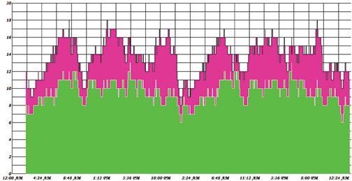
FIGURE 1. GPS (green) and GLONASS (pink) constellation visibility in Tokyo for 48 hours. Note that GPS visibility picture repeat itself every 24 hours, and GLONASS visibility changes. It also illustrates why GLONASS satellite orbits are less affected by gravitational filed irregularities.
Further, more systems mean more reliable service. Healthy competition will only benefit users. Compatibility of the systems had been be improved and will be improving further. Two systems will provide higher accuracy and higher integrity.
The international GLONASS market can increase due to the fact that countries that do not own their satellite navigation system can provide some redundancy in their infrastructure if they implement GNSS from different owner/operators. This, however, becomes less important as other navigation satellite systems, such as Galileo, come to life. Also, more satellites will benefit users, who operate in urban or other obstructed environments.
Accuracy. It has been generally accepted that the real-time accuracy of GLONASS is less than that of GPS. The main source of accuracy degradation comes from broadcast ephemeris and clock parameters. For many users, it is possible to use precise ephemeris, freely available on the Internet from, for example, the International GNSS Service (IGS), formerly the International GPS Service, a voluntary federation of more than 200 worldwide agencies that pool resources and permanent GPS and GLONASS station data to generate precise GPS and GLONASS products.
We also have analytical centers similar to, and some within, the IGS. Four analytical centers wi
thin the IGS are estimating GLONASS ephemerides, and two of them are estimating GLONASS clocks. The accuracy of precise GLONASS ephemeris are within 4 centimeters, 1 sigma.
Using precise ephemeris, or differential service, a GLONASS user can mitigate the above-mentioned error sources and enjoy higher accuracy comparable with those of GPS. In the future, a global network, even a commercial one, can further benefit GLONASS in terms of higher real-time accuracy.
Summarizing, we expect the GLONASS market worldwide to grow, though less rapidly than the internal market in Russia. We see our business in providing global solutions, which includes GLONASS, GPS, and Galileo, to the global market of GNSS users worldwide. The standard for navigation systems in the future will be multifrequency, multi-constellation user equipment, and we are well on the way to meeting this standard.
VASILIY ENGELSBERG is president of NVS Technologies AG and co-founder of NAVIS.
IVAN PETROVSKI is NVS director. Among his numerous responsibilities, he is in charge of research and development and the Asia-Pacific region.
VALERY BABAKOV is co-founder and general manager of NAVIS. Babakov explains, “Our company is a center of the NAVIS group, which is the main supplier of GLONASS receivers in Russia. NAVIS itself is about a 300-person company. The main area of our activity is the creation of navigation and timing equipment, based on GLONASS/GPS signals.
“We produce technologies and equipment that use GLONASS and GPS signals, including navigation equipment for marine and airborne applications, devices of time-and-frequency synchronization for communication systems, and GPS, GLONASS, satellite-based augmentation systems (SBAS), and Galileo simulators.Our current GPS/GLONASS receiver Navior seems to present interest to a wide range of customers worldwide. “Working in today’s market, we are covering all components of user service starting from conceptual engineering, to technical project development, delivery, assembling and launching of equipment, and finally providing users with training, technical support, and maintenance during exploitation.
“As part of the process of integration of our technologies into the worldwide GNSS market, NVS Technologies had been established. NVS Technologies is a new company, which aims to bring a wide range of GNSS products to the market and is envisioned to combine the experience of Russian NAVIS and NAVIS Ukraine in GPS and GLONASS user equipment development with Swiss quality and expertise in international marketing.
“Our company group now is not only engaged in the GLONASS business, but also looking forward contributing to Galileo equipment development. We are participating in the Galileo Integrated Receiver for Advanced Safety of Life Equipment (GIRASOLE) project together with Thales Avionics and Thales Aleniaspace. Our part in the GIRASOLE project is to provide the Galileo L1/E5 simulator. To facilitate simulator development, we have built a Galileo prototype receiver, which can acquire and track the GIOVE-A signal. Working with our SN3806 simulator, the receiver can also make a positioning. In November 2007 our engineers conducted a three-day tutorial on our GNSS simulator in Thales Avionics premises in Valence.”