ITT Corporation has been awarded a contract for the next-generation GPS Command and Control Systems designated OCX by the U.S. Air Force. ITT is part of a team, led by Raytheon Company, that will develop a system design and prototype of the OCX system. A system design review and prototype demonstration is scheduled for early 2009.
“This is a significant achievement for ITT,” said Chris Young, president of ITT Space Systems Division. “OCX represents our first, strong push into the GPS control segment.”
OCX is intended to improve command and control of the GPS constellation, improve mission capabilities, and provide a more user-oriented environment. Once implemented, Air Force Space Command can improve operational services for civil and military customers worldwide. The first phase of the contract will focus on defining the long-range architecture, technical requirements, concepts of operations, and fielding capabilities incrementally. Issues related to the introduction of future GPS III satellite blocks into the constellation also will be part of the OCX’s first contract phase.
“The cornerstone of our solution is a versatile, service oriented architecture,” said Young. “Our design will enable the government to implement low-cost, targeted software upgrades that won’t ripple undesirably throughout the system.”
As we look forward in the modernization of GPS, and we’re looking at the spectrum of other systems that are coming online, GPS today has fundamentally the preeminent position in terms of positioning and navigation. If we don’t shoot ourselves in the foot in the transition from the GPS we have today to GPS III, which is 10 years out, GPS will probably remain the fundamental standard, because the only way non-military uses of these additional systems will get early use is by receiver manufacturers putting in dual-reception capability and using the new satellites as they go up, fundamentally as additional ranging signal augmentations. It’s the only way you get early use out of getting a few satellites in the sky.
A lot of whether GPS will retain its standard position has to do with worldwide confidence in the system. We’ve done a pretty good job of maintaining a level playing field for everyone in the world with regard to GPS. There haven’t been the problems that were experienced with Loran systems which were occasionally turned off, creating consternation in Europe. But the possibility, currently under consideration, of actually dropping an important accuracy augmentation element of GPS — the Nationwide Differential GPS (NDGPS) — before alternatives are available would certainly undermine worldwide confidence in the U.S. commitment to continuing to provide service equal to or better than what is already there.
The key issue here: You can have all the paper designs in the world you want, but fundamentally the question is once you have a given level of capability, how well is that maintained — and is it improved over time?
With all the machinations that have gone on, the United States has done a pretty good job. It basically delivers a set of signals that are better than promised. The system, especially with its augmentations, is clearly better today than it was 10 years ago.
Now, the U.S. from a policy standpoint does need to transition from where we are to GPS III. We simply need to do it in a wise manner. The problem that I see with zeroing out the budget for NDGPS is that we save very little money — about $10 million a year to maintain the system. For any accountancy firm, this would fall below the line of relevance in the budget. And the effect, in undermining international confidence in GPS and in direct costs to state and local governments, would far outweigh any such savings.
Until we have something in GPS III that provides accuracies in the half-meter range, which is what’s required for civil Geographic Information Systems (GIS) work, it would be foolish to turn NDGPS off. We would be degrading a system without any real alternative.
Furthermore, you’re probably going to cost state and local and federal governments, who use NDGPS extensively for local mapping, far more than $10 million by turning the system off.
I believe the main commercial use of NDGPS, outside of the GIS realm, is precision agriculture. The arguments to put it in originally were to provide the people on the interior of our continent the same sort of services that the coastal regions are provided. The issue we have is we don’t have a strong vocal constituency, and frankly state and local governments can’t provide much of a hue and cry for degradation of service.
And losing confidence, undermining international confidence in the U.S. to maintain a stable system, is not a party to the table, either.
Granted, international users do not actually use NDGPS itself. But they have invested the money to put in comparable base stations in their countries. For the U.S. to discontinue NDGPS undermines and brings into question whether their investment was a good investment — and whether, as an international user, you can comfortable continue to rely on GPS.
It’s a confidence issue. There is no economic damage to foreign users. But it’s a perception of undermining GPS credibility across the globe if we pull back support from a system that just a few years ago we deemed to be important and almost essential.
Some precision ag and other potential NDGPS users have switched over to WAAS, the Wide Area Augmentation System. There’s no question that WAAS is a good system, but you’re not going to get below a couple of meters, and you’re certainly not going to be able to farm above buried water tape. There’s clearly a market and I believe it’s part of the mix. It turns out it’s really tough to get at the 20-centimeter accuracy level over large distances, and WAAS will not give you that.
At some point in our transition — I don’t know whether it’s five years from now or 10 years from now — the world is going to be a different place in terms of satellite services and the level of satellite services. It may very well be at some point in the future, this space of 20–50 centimeter accuracy can be very well delivered by a private service (without interference in the RF spectrum), or let’s just say, can be delivered by satellite.
At that time, when there are truly other alternatives, I’m not going to be beating my shoe on the desk to maintain a legacy system. The issue in this whole positioning and navigation field is that as people are starting to get economic value out of information, introducing hiccoughs into the user stream of productivity enhancement is not a good thing.
We say that until there is a viable alternative for the 20–50 centimeter space, we ought to continue sending out the signals. Once there is a viable alternative, then you can certainly transition; look at the cost of transition, and you will probably transition.
But it turns out this is a relatively cheap way of providing information in this space and, frankly, we’re a long ways away from using GPS in automated systems that are directly related to safety of life. To get that, you have to play the game that the FAA plays, and worry about seven nines of reliability [99.9999999 percent]. GPS in its augmentation is probably at the one to two nine level. But as the usage increases, by having multiple augmentation systems and using them, there is no reason that reliability can’t be increased.
Fundamentally, the word to government is it’s premature to shut off the lights. It may be the right decision at some point in the future, but I think it would cause a lot more problems than the $10 million it would save if it’s done now.
CHARLES R. TRIMBLE is chairman of the U.S. GPS Industry Council.
In a statement late Tuesday, the White House said that President Bush has agreed with the U.S. Department of Defense recommendation to permanently do away with Selective Availability, the intentional degradation of the civil GPS signal.
Specifically, the statement said that the U.S. would no longer require that the ability to introduce timing errors in the GPS signal reserved for civilian use be built into future generations of GPS satellites; it specifically cited Block III spacecraft.
The White House acknowledged that this was following on the decision in 2000 to turn Selective Availability off. “Although the United States stopped the intentional degradation of GPS satellite signals in May 2000, this new action will result in the removal of SA capabilities, thereby eliminating a source of uncertainty in GPS performance that has been of concern to civil GPS users worldwide,” the statement said.
In simple terms, GPS satellites currently issue two different sets of signals used for determining location: one for the U.S. military and its allies, dubbed the Precise Positioning Service, or PPS, and one for civilian use, dubbed Standard Positioning Service, or SPS. PPS actually comprises two signals and is encrypted, whereas SPS only uses one and is unencrypted; it was designed from the start to be less accurate than PPS. When GPS came about, the military — the GPS satellite fleet is maintained through the U.S. Air Force — didn’t want its own technology being used against it in a conflict, so it intended to make the civilian signal less accurate.
Early on, however, SPS proved more accurate than was comfortable for the military, so it introduced Selective Availability (SA). SA degraded the accuracy of the civilian signal on a global basis by introducing intentional timing errors into the civilian signal.
Back in 2000, the U.S. government decided to turn off SA indefinitely, which is one of the factors in the growing adoption of GPS technology in consumer electronics today. This latest pronouncement from Washington D.C. effectively makes the policy change with regard to SA a permanent one.
The U.S. military says SA is no longer necessary, as it has a range of capabilities and technology to implement regional denial of service of civilian GPS signals when needed in the area of conflict — which is why it originally recommended doing away with SA back in 2000. Furthermore, since the advent of GPS, a range of technologies including supplemental satellite and ground-based navigation systems (such as DGPS, WAAS and EGNOS) have grown up to improve the accuracy of civilian GPS, essentially rendering SA moot.
Furthermore, the U.S. Air Force has acknowledged that a recent upgrade to the GPS ground control system will in the future provide a new “security architecture” for supporting troops in combat.
The U.S. Air Force Space and Missile Systems Center (SMC) announced in late August that the long-planned upgrade of the GPS command and control system will occur during the second week of September, fulfilling a major program commitment for 2007.
Dubbed the Architecture Evolution Plan (AEP), the upgrade will replace the entire GPS master control station, including both software and hardware, some of which dates back to GPS’s inception in the 1970s. The upgrade will, among other things, begin preparing the master control station to work with the latest generation of Block IIF satellites when they go into orbit; further work with the next-generation OCX, however, will be necessary for managing M-code and the new L5.
“The delivery of SMC’s new GPS ground segment to the 50th Space Wing [will enable] transition of satellite operations from a 1970s-era GPS mainframe computer to a new server-based AEP ground segment,” said Lt. Gen. Michael Hamel, SMC Commander. “I am very proud of the team that has thoroughly tested the new system to ensure no change to the GPS signal during the changeover to the new system. The best analogy I could make is that this is like changing the engine on a car while traveling 50 miles an hour down the road.”
Col. David Madden, GPS Wing Commander, added “The replacement of the legacy system to AEP is a benefit to both the warfighter and the civil community. AEP is designed to improve operations, increase efficiency, and provide a foundation for new capabilities as they become available. The replacement from the legacy mainframe system to a distributed architecture provides the capability to command and control the next generation of GPS satellites and lays the foundation for a new security architecture to support the warfighter in the field.”
The AEP transition will take place over a period of four to six days; the total cost of the new ground control system amounts to approximately $800 million. The Air Force will not announce the exact date and time of transition, but will inform users 48 hours after completion.
The upgrade features a new satellite control foundation that replaces the legacy system and adds new digital communications. This means installing and activating a new master control station at Schriever Air Force Base which includes new hardware and software to generate navigation messages, a new system for controlling satellites, and new capability to command satellites through the Air Force Satellite Control Network (AFSCN). Adding the AFSCN will increase the number of available antennas for contacting satellites. The upgrade also involves installing and activating the alternate Master Control Station at Vandenberg AFB in California, and upgrading the current GPS ground antennas.
Ground control at Schriever AFB will phase in a few satellites in the GPS constellation at a time; the process will be completely reversible if it encounters any problems. Before it begins, both old and new ground control systems will be synchronized in terms of positioning data, namely their reception of satellites’ timing and navigation signals, down to the millimeter level. GPS users should not notice the transition, according to the Air Force.
The AEP will retain all of the legacy monitoring stations around the world currently utilized by the U.S. Air Force, as well as the National Geospatial-Intelligence Agency (NGA) monitoring stations around the globe originally added as part of the Legacy Accuracy Improvement Initiative. Additional NGA monitoring station sites are in the process of being brought online for future inclusion within the AEP.
Galileo Tests; Rescue Role
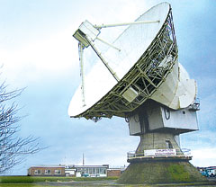
The antenna dish at Chilbolton Observatory.
The test campaign using the large antenna at Chilbolton Observatory to analyze the navigation signals transmitted by GIOVE-A, the first Galileo satellite, has been successfully completed, the European Space Agency (ESA) announced in mid-August.
Analysis of the satellite’s signals since January 2006, to verify their conformance with the Galileo system specification, has involved the Navigation Laboratory at ESA’s European Space Research and Technology Centre (ESTEC) in the Netherlands, the ESA ground station at Redu, Belgium, and the Rutherford Appleton Laboratory (RAL) Chilbolton Observatory in the United Kingdom.
Following signal analysis, operators have made some adjustments, re-programming the spacecraft’s navigation signal generation unit to compensate for changes to the signals introduced by the amplifier that boosts them for transmission to Earth and by a filter that protects adjacent frequency bands from interference.
To achieve the correct solution, the calibrated Chilbolton station was used to receive the signals from GIOVE-A. ESA’s Navigation Laboratory processed the resulting data. The signal generator manufacturer, TAS (France), calculated the new settings for the unit. Finally, the satellite manufacturer, Surrey Space Technology Limited (SSTL), uploaded the new values to the payload using their ground station at Guildford, in the United Kingdom.
According to ESA, “GIOVE-A is now transmitting optimized signals. Research and testing continues, and manufacturers are using the signals as they develop the receivers that users will need when Galileo enters operational service.”
Global Search and Rescue. Once operational sometime after 2012, Galileo will improve the detection of emergency beacons, according to program representatives whoattended the annual Joint Committee Meeting of COSPAS-SARSAT, the international program for satellite-aided search and rescue. Galileo satellites will carry transponders to relay distress signals to search and rescue organizations. Galileo partners have committed to developing a search and rescue component as an integral part of Medium Earth Orbit Search And Rescue (MEOSAR), the future worldwide search and rescue satellite system.
COSPAS-SARSAT already has systems operating in low-Earth orbit and geostationary orbit. The low-Earth orbit satellites can determine the location of emergency beacons using the Doppler effect as they pass overhead. However, there is a delay in relaying the distress signal because the satellites can only “see” a part of the Earth’s surface at any given time and a beacon is only detected when the satellite passes nearly overhead. Also, the satellites must store the location of the emergency and transmit it to a ground station once one comes into range, creating further delay.
Search and rescue transponders on geostationary satellites can constantly view a large, fixed area of the Earth, eliminating the time delay in detecting distress signals. However, they cannot automatically determine the location of the distress beacon as the low-Earth orbit system does, but must rely on the beacon to use a navigation system to find its position and include it in the distress call.
Emergency beacons require a direct line-of-sight to the geostationary satellites. There are some situations where this is impossible, such as near the Earth’s poles, where the satellites are too low in the sky, or when an accident occurs where surrounding terrain obscures the satellite.
Future Improvements. To improve performance of the overall COSPAS-SARSAT system, plans are now being made to fly search and rescue payloads on future navigation satellites. The various navigation satellite constellations will each have about 20 to 30 satellites in medium-Earth orbit, providing global coverage, including at the Earth’s poles, and with multiple viewing angles to the satellites, eliminating terrain blocking.
The Galileo search and rescue component will provide two services. The Forward Link Alert Service, backward-compatible with current COSPAS-SARSAT components and interoperable with all other planned MEOSAR elements, detects activated distress beacons and notifies the appropriate rescue body. A new Return Link Service will send a return message to the emergency beacon, notifying the emergency victims that their distress signal has been received and help is on its way.
The Galileo In-Orbit Validation Programme, which will have four satellites fitted with search and rescue transponders, will demonstrate the Galileo MEOSAR services — although its flight timetable has yet to be finalized or announced.
DOT Weighs NDGPS Future, Asks Public Input
The U.S. Department of Transportation’s (DOT) Research and Innovative Technology Administration (RITA) is preparing an assessment on the inland component of the Nationwide Differential Global Positioning System (NDGPS) that will determine its future.
As part of that assessment, it is seeking public input from users of the system.
The current expansion of the NDGPS has been placed on hold pending congressional review of the system’s funding; RITA’s assessment is part of that review. Differential GPS uses the fixed location of a reference station on the ground to improve the positioning resolution provided by civilian GPS satellite signals down to 1–3 meters. NDGPS facilities also monitor GPS satellites for anomalous behavior and issue integrity warnings when necessary.
The NDGPS program is operated jointly with the DOT’s Federal Highway Administration, Federal Railroad Administration, and Office of the Secretary of Transportation; the Department of Homeland Security’s U.S. Coast Guard; the Departmentof Commerce’s National Geodetic Survey and Forecast Systems Laboratory; and the Department of Defense’s Air Force and Army Corps of Engineers. Begun in 1997, to date there are 37 operational NDGPS sites. Two additional sites are ready for construction and could be operational in a matter of months, according to the Coast Guard.
As part of the assessment, RITA published a notice in the Federal Register addressing the current user requirements for the inland or terrestrial component of the NDGPS. This assessment is in preparation for making a recommendation to the National Space-Based Positioning, Navigation and Timing (PNT) Executive Committee, which oversees the entire GPS, on the need to continue to operate inland NDGPS and to make a decision on its future funding.
If no transportation requirements or other federal user requirements are identified as a result of the needs assessment, and if there are no other federal or other funding sources willing to sponsor or partner in sponsoring NDGPS, the DOT will develop a decommissioning plan for NDGPS, according to RITA.
The deadline for public comment is October 1, 2007. Comments may be submitted via the Internet at the Department of Transportation Web site. Instructions for other methods of submitting comments, including via postal service and fax, can also be found there in the docket management portion of the site.
The Robots of DARPA
The U.S. Defense Advanced Research Projects Agency (DARPA) has named 36 teams as semifinalists for its Urban Challenge to take place later this year.
The DARPA Urban Challenge will feature autonomous ground vehicles executing simulated military supply missions in a mock urban area. It will take place November 3at an urban military training facility located on the former George Air Force Base in Victorville, California.
The 36 semifinalists will compete in the Urban Challenge National Qualification Event (NQE), October 26–31. The top 20 teams from the NQE will move on to the Urban Challenge final event on November 3, and compete for cash prizes worth $2 million for first, $1 million for second, and $500,000 for third place.
At the NQE and the final event, the robots must operate entirely autonomously, without human intervention, and obey California traffic laws while performing maneuvers such as merging into moving traffic, navigating traffic circles, and avoiding moving obstacles. DARPA conducted competitive site visits across the United States to select the semi-finalists.
“The depth and quality of this year’s field of competitors is a testimony to how far the technology has advanced since the first Grand Challenge in 2004,” said DARPAdirector Tony Tether.
Stanford University’s winning robot vehicle from the last DARPA Challenge in 2005, which ran across the Mojave Desert, consisted of a stock Volkswagen Touareg R5 thatincorporatesd measurements from GPS, a 6DOF inertial measurement unit, and wheel speed for pose estimation.
RITA and the Coast Guard have a tough job ahead. Between them, the Department of Transportation’s (DOT’s) Research and Innovative Technology Administration and the multi-mission maritime service are trying to save a national differential GPS (NDGPS) program that faces termination next year.
History. The U.S. Coast Guard (USCG) implemented the concept in the mid-1990s. Their requirement was for marine navigation, and the system now provides service for coastal coverage of the continental United States, the Great Lakes, Puerto Rico, portions of Alaska, Hawaii, and a greater part of the Mississippi River Basin. In a testament to NDGPS’s success, many countries around the world have duplicated the concept.
Since the DGPS signal is broadcast in a 360-degree radius, inland users close enough to the USCG broadcasting station can receive and use the corrections. All of this happened before SA (Selective Availability) was turned off, so the accuracy improvement was staggering; from 100 meters down to 1-3 meters. Once inland users tasted the sweetness of the USCG DGPS system, a groundswell of support arose for expanding the system inland. The NDGPS system was born.
Manufacturers began to integrate “Coast Guard” DGPS receivers into their products. Companies like CSI and Starlink offered after-market DGPS receivers to enable virtually any GPS user to receive the free DGPS signal, whether it was a $200 consumer GPS unit or a $10,000 submeter mapping receiver. Since then, tens of thousands of “Coast Guard” DGPS receivers have been sold around the world.
Between the USCG, the Army Corp. of Engineers (USACE), and the DOT, 86 stations now blast out DGPS corrections free of charge that cover more than 90 percent of the U.S. landbase.
Trouble. The program ran smoothly through the first half of this decade. Each year, a few new stations were added to expand coverage. The HA (High Accuracy)-NDGPS concept to provide decimeter-level positioning was proven to work. However, the rug flew out from under NDGPS last year when DOT’s Federal Railroad Administration (FRA) announced it would no longer sponsor NDGPS. NDGPS supporters had long hung their hats on Positive Train Control (PTC) as the killer application for NDGPS, as it would save the railroad industry billions per year and justify the cost of installing and maintaining the NDGPS. The DOT says the PTC doesn’t need NDGPS any longer.
Two significant developments have reduced the need for NDGPS since the program began. The first is that autonomous (standalone) GPS accuracy is very good these days, on the order of a few meters. The second is the maturation of the Federal Aviation Administration’s Wide Area Augmentation System (WAAS).
RITA to the Rescue. Last summer, with no FY07 budget for NDGPS, the scrambling began. The FRA washed its hands of NDGPS so the DOT transferred the program to a little-known agency called Research and Innovative Technology Administration (RITA). At the eleventh hour, RITA scraped up $5 million for NDGPS for FY07 — enough to operate and maintain the system until October 2008. $400,000 of that is allocated for “needs assessment.” In other words, they need to understand who is still using NDGPS and determine if the usage justifies future funding.
The USCG (39 sites), USACE (9 sites), and DOT (38 sites) fund the 86 stations. USCG has said it would take over 12 of the DOT-funded sites if DOT decides not to fund the program. So the debate only involves about a third of the U.S. land mass. The USCG and USACE sites are not in jeopardy, as their requirements are considered safety-of-life for maritime navigation.
Is there is a significant enough user base in the areas above to justify the roughly $7 million a year it takes to operate and maintain them? If there are only 1,000 users in those regions who use it regularly, that’s $7,000 per year, per user. That scenario doesn’t make sense. And it doesn’t even consider the cost of complete system build-out. Even at 10,000 users (a very unrealistic number), that’s still a cost of $700 per year, per user to the taxpayer.
Who still uses NDGPS, anyway? That’s the magic question, and the DOT doesn’t know the answer. Presumably, determining that is part of the needs assessment, to be
finalized in September 2007. I’ve heard speculators talk about agriculture being a big NDGPS user. While this might have been true five years ago, WAAS now dominates the ag market. Even CSI (now Hemisphere GPS), the largest producer of after-market “Coast Guard” beacon receivers and the leading GPS supplier to the ag market, has shifted its focus from NDGPS receivers to high-performance WAAS receivers.
The forest products industry comprises some big users of GPS, but they’ve been post-processing for years, and some have even stopped doing that because autonomous GPS is sometimes good enough.
What’s left is a fragmented group of utilities, federal/state/local government, engineering, surveyors, universities. and various -ologists. Honestly, as much traveling, conference attending, speaking engagements, and training as I do, I can’t recall the last person who told me they use NDGPS. That’s the fundamental problem.
The Air Force Space and Missiles Systems Center’s GPS Wing has announced a new contract to the Science Applications International Corporation (SAIC) team for systems engineering and integration (SE&I). Contract value is $217 million if all options and maximum award fee are exercised over the five-year contract period of performance.
“This is an important shift in how the Air Force manages space acquisition programs,” said Lt. Gen. Michael Hamel, SMC commander. The announcement cited increased modernization activity in virtually every element of the GPS enterprise as a driving force for the change.
The Air Force continues to serve as the responsible program authority “systems integrator,” with full responsibility, authority and accountability for the system-wide engineering and integration of the entire GPS enterprise — space, ground, and user equipment. The new SE&I contract will have specific deliverable products using documented work plans and product-oriented focus which will ensure engineering process discipline, interface, and configuration control as well as rigor and consistency across the entire GPS organization, according to the announcement.
The SAIC team for SE&I includes: LinQuest, Booz Allen Hamilton, Harris, General Dynamics, Raytheon, Loral Space Systems, Ducom Inc, Epsilon Systems Solutions, Inc, Integrity Applications Inc, MacAulay Brown Inc, MCR Federal Inc, Munoz Engineering Inc (MEI) Technologies, Overlook Systems Technologies Inc, Saalex Solutions Inc, and Teledyne Brown Engineering.
The U.S. Air Force has awarded Lockheed Martin a $6 million contract to develop and demonstrate a payload that will temporarily transmit a third civil signal, on the L5 frequency at 1176MHz, from a Block IIR-M satellite.
Previous plans called for the L5 civil signal, aimed principally at safety requirements in civil aviation, to appear on the Block IIF satellites. Early speculation posits that the Air Force may want to conduct some signal testing before the IIFs are launched, or secure the frequency according to ITU requirements, as GIOVE-A did for Galileo.
Lockheed Martin and its navigation payload supplier ITT will provide an in-orbit demonstration of the new civil signal.
On December 6, 2006, the sun emitted a burst of radio energy that impacted the performance of GPS receivers all over the sunlit side of the Earth. That the sun produces radio emissions is not surprising. What is surprising is that on this day they were extremely powerful. The sun continuously emits energy across a broad region of the radio spectrum. The flux density of these emissions is normally fairly low and contributes imperceptibly to the background radio noise collected by GPS receiver antennas.
However, when a solar flare occurs, it is often accompanied by very powerful bursts of radio energy. Although they are more numerous near the peak of the solar sunspot cycle when the sun is more disturbed, solar flares and their associated strong radio bursts can occur at anytime – including near the current sunspot minimum. Still, the December 6 solar radio burst came as a surprise. It was one of the largest on record and had an impact on all GPS receivers on the sunlit side of the Earth, including most of North America, South America, and the Pacific Ocean. The added noise significantly reduced carrier-to-noise-densities (C/N0 – a measure of the strength of received signals) at both the L1 and L2 frequencies by as much as 15 dB-Hz. This resulted in receivers losing lock on some satellites for many minutes, particularly those at low elevation angles with low C/N0 values before the burst’s arrival. Those receivers closer to the sub-solar point were typically affected more than those further away as more or the burst energy was picked up by the receiver antennas.
Nevertheless, it appears that a lot of single-frequency receivers continued to provide navigation solutions with as few as four satellites — and even three in 2D mode — and the noise burst went unnoticed by most users of such receivers. However, many dual-frequency receivers used for high-accuracy applications including those at reference stations suffered significant signal losses, particularly at the L2 frequency. As well, military receivers in some sectors lost the ability to navigate. A “widespread loss of GPS” in the Four Corners region of New Mexico and Colorado was reported by military authorities. Several aircraft reported losing lock on GPS signals with the number of tracked satellites dropping from 7-9 to 1 or even none!
Alessandro Cerruti, a graduate student at Cornell University, is among a group of scientists and engineers studying the effects of this and other solar radio bursts on the operation of GPS receivers. He has examined the data provided by the receivers in the International GNSS Service (IGS) network on the sunlit side of the Earth. The number of stations providing data at both frequencies on at least four satellites dropped from more than 120 to below 60 during the burst. The timing of the drop-outs coincides with the power of the burst which is shown in the lower panel.
The burst power was recorded at the Owens Valley Solar Array (OVSA) in California’s high desert. Operated by the New Jersey Institute of Technology’s Center for Solar-Terrestrial Research, OVSA records solar radio emissions at over a range of frequencies and polarizations including right-hand circular polarization (RHCP) at 1.6 GHz, very near the GPS L1 frequency. As the plot shows, noise power exceed one million solar flux units at the peaks of the burst, making this burst one of the largest on record.
Alessandro Cerruti has also looked at data from the Wide Area Augmentation System (WAAS) which is very robust and although WAAS continued to operate throughout the period of the burst, signals at the WAAS reference stations suffered significant degradations as elsewhere. The C/N0 values for PRN 4 as recorded at the Houston reference station on both the L1 and L2 frequency for a quiet day and on December 6. The drop in C/N0 values during the burst is very dramatic.
Mitigation. What can be done, if anything, to mitigate the effects of solar radio bursts? As the bursts are broadband noise, it is difficult for a receiver to discriminate them from GPS signals. Some antenna designs, such as choke rings, attenuate signals arriving at low elevation angles, so if the sun is low in the sky at the time of a burst, receivers with such antennas will be less impacted than those with conventional antenna designs. And as a receiver loses track primarily on satellites at low elevation angles, having more satellites at higher elevation angles will also help. So receivers operating with a mixed constellation of GPS and GLONASS or GPS and Galileo satellites should be better able to weather a solar radio burst than those operating with GPS alone. Similarly, a larger GPS constellation by itself would help.
Modernization. Stronger transmitted signals from future GPS satellites might allow receivers to continue tracking even low-angle satellites during a large burst. Newer signal formats, which could be tracked at lower C/N0 values, would also help receivers to contend with the sun’s outbursts. Even current receiver technology developed for anti-jamming protection and for indoor GPS use would allow receivers to track to much lower C/N0 values and perhaps sail through even very strong solar radio bursts.
As we approach the peak of the next sunspot cycle in 2012, we can expect more solar radio bursts. Some forecasts peg the next peak at 30–50 percent stronger than the last one as measured by the fraction of the sun’s visible hemisphere with sunspot activity. Will future solar radio bursts have as dramatic an effect as the burst of December 6, 2006? Time will tell.
China launched its fifth Beidou/Compass navigation satellite on Friday, April 13. The initial orbital elements (inclination = 55.0°, eccentricity = 0.62, mean motion = 3.84 orbits per day) may indicate that this is not another GEO satellite but rather the first of the MEO satellites.
Meanwhile, it seems that NORAD had “lost” the 4th Beidou satellite for awhile. Launched on February 2, the satellite reportedly had a problem with a stuck solar panel which needed to be fixed before the satellite could be transitioned from its geostationary transfer orbit to its intended geostationary location. The last publicly released element set for this satellite had been dated 8 March 2007. Perhaps this was the day the Chinese started to move the satellite to its geostationary position.
NORAD released an element set for the satellite in its near geostationary orbit. NORAD is currently reporting the satellite to be in an inclined orbit (6.3°) with a sub-satellite longitude of about 144°E. The latest Beidou/Compass might not be heading for GEO but either to an inclined geosynchronous orbit or MEO, similar to that of GPS and GLONASS satellites.
The Chinese have talked about various Beidou/Compass options:
4 GEO + 9 inclined (50°) geosynchronous
4 GEO + 12 MEO (55° x 20,200 km)
30 MEO (56° x 21,363 km)
In one of their ITU filings, the Chinese referred to some of the satellites as Compass-M.
Why are GLONASS satellites launched on Christmas Day? Question posted on CANSPACE on December 10, 2006, by Kerry Matthews
The latest triple-satellite GLONASS launch occurred on December 25th at 23:18 Moscow Time. This launch is the sixth GLONASS December launch in a row. In fact, all 9 launches since December 1995 have occurred in the last month of the year with the exception of the launch on October 13th, 2000 (see a list of GLONASS launches going back to 1990).
Including this month’s launch, three of the recent launches have occurred on December 25th and one originally scheduled for the 25th, occurred on the 26th. Why the preponderance of December launches and launches on Christmas Day in particular?
First of all, we should realize that for most people in the Russian Federation, there is nothing special about December 25th. Most Christians in Russia belong to the Russian Orthodox Church which celebrates Christmas according to the Julian calendar — on January 7th. And in modern Russia, January 7th is a state-wide holiday. So, GLONASS launches don’t occur around December 25th because it’s a special day on the Russian calendar. So why do they occur then?
I posed this question to Col. (ret.) Nikolai Shienok, the former chief of the Information Department of the Coordination and Scientific Information Center of the Russian Ministry of Defense. After conferring with officials from Roscosmos (the Russian space agency) responsible for the GLONASS program, Col. Shienok confirmed that it is only for financial or organizational reasons that there is a preponderance of launches in December. “It is the last month of the year and it is impossible to postpone a planned launch further” Col. Shienok said.
Nevertheless, there may be some operational calendar constraints on GLONASS satellite launches as there are for launches of other satellites. Satellite operators typically try to avoid launching satellites when the Sun-orbit-plane or beta angle for the intended orbit is unfavorable. The beta angle is the angle between the geocentric position vector to the Sun and the satellite’s orbital plane. This angle determines if and for how long a satellite will be in the Earth’s shadow during its orbit. For a given orbit (altitude, inclination, and initial right ascension of the ascending node), the beta angle will vary over the year. Operators try to avoid a launch date when the satellite would be in eclipse for a significant fraction of its orbit so that during the crucial satellite deployment and commissioning phase, the satellite’s solar panels receive as much sunlight as possible to keep the satellite’s batteries fully charged. The recent GLONASS launch put the satellites into Plane 2 which is actually in one of its eclipse seasons right now. However, the satellites will be out of eclipse by early January.
SVN23, the first Block IIA satellite to be launched (as PRN23), has been reactivated as PRN32. This satellite was launched on November 26, 1990, and initially decommissioned on February 13, 2004, after more than 13 years of service. SVN23/PRN32 is in slot E5 and is operating on its Rb2 clock.
PRN32 was last used by SVN32. It used that code until January 28, 1993, when its code was switched to PRN01.
It is believed that SVN23 was initially reactivated with a non- standard code that cannot be tracked by standard GPS receivers. However, on December 2, it started to transmit the standard PRN32 code. Nevertheless, the satellite was set unhealthy as it reportedly had been reactivated only for test purposes.
Richard Langley provided this information in a footnote to his Navstar GPS Constellation Status report of November 4, 2006, posted to users of the CANSPACE list service (contact [email protected] to subscribe). As reported by Stephan Schaer of the Center for Orbit Determination in Europe, some “all-in-view” stations of the IGS tracking network (which can track both healthy and unhealthy satellites) began receiving SVN23/ PRN32 signals on December 2. However, it seems that some manufacturers’ receivers were unable to track a satellite with a PRN number of 32.
On December 7, the GPS Operations Center at Air Force 2nd Space Operations (2SOPs) issued this Notice Advisory to Navstar users (NANU): “An initial assessment period for SVN 23 utilizing PRN 32 was accomplished 1 December to 6 December 2006; SVN 23 is no longer transmitting L-band.
“During this assessment period SVN 23 was broadcasting L-band and set unhealthy. SVN 23 was not included in the operational constellation almanac.
“Any users that experienced unusual performance from GPS user equipment during this period should contact the GPS Operations Center.
“Approximately 10 January 2007, SVN 23 utilizing PRN 32 will be turned on; transmitting L-band and kept unhealthy. SVN 23 will still not be included in the operational constellation almanac. The GPS Operations Center will transmit a General NANU reminding users of this activity.”
Testing, Testing. As reported in the November, 2006 issue of this magazine, the Air Force issued an earlier memorandum stating that the November 17 launch of SVN58/PRN12 would set a new mark of 31 operational satellites, and that operational control could go beyond 32 satellites. As most current civil receivers are set at 31, this has important ramifications that manufacturers should consider.
The GPS Operations Center continues to seek feedback on potential impacts the largest-ever GPS constellation may have on users and equipment. “Although future versions of our interface spec, IS-GPS-200, will accommodate a larger constellation for the next-generation GPS, the most pressing concern is with potential impacts to existing fielded GPS receivers that may not properly account for up to 32 operational PRNs.”
The early December and January L-band broadcasts by SVN 23 may represent tests to assess various aspects of that future eventuality.
This One’s for Real. Meanwhile, the new GPS IIR-M satellite SVN58/ PRN12 was declared operational on December 13.
Galileo Guess Who
EU States Vie to Host Supervisory Authority
No fewer than eleven European Union (EU) member states have their hands in the ring to grab hosting of the Galileo Supervisory Authority, tasked to take over from the Galileo Joint Undertaking on January 1, 2007, and manage the EU satellite navigation program. Ministerial meetings among the candidate states could not resolve the matter, nor could the EU leaders’ summit, December 11-12, make the politically charged decision.
Deliberations were postponed until the incoming German presidency in January and the next Transport Council meeting in February. Discussion focused on whether the decision should respect an agreement reached in 2003 providing for the new member states to be given priority in hosting new agencies.
Race Card. Eleven countries have ponied up their candidate sites: Belgium (Brussels), the Czech Republic (Prague), France (Strasbourg), the Netherlands (Noordwijk), Italy (Rome), Malta (Valetta), Germany (Munich), Greece (Athens), Slovenia (Ljubljana), the United Kingdom (Cardiff), and Spain (Barcelona).
According to the EU protocol, new “decentralized” agencies should go to new member states, that is, predominantly those in Eastern Europe. Only Poland currently hosts one of these, and all the founding 15 states already have an agency. So, presumably, Malta, Slovenia, and the Czech Republic would appear to have pole position. They are truly dark horses, however, as national contributions to the Galileo budget run much higher in the industrialized, space-age West, and these commitments come with significant quid pro quo.
Security. Concern has surfaced from some old member states about the security of the site, since the agency will oversee highly sensitive information. The Czech Republic is making a particularly strong push for host designation, witha Czech spokesperson later stating “Prague has fulfilled the security conditions.” Angered by the debate — which may or may not represent a stalking horse for more real economic motives — the Czechs could block a move to host in an old member state city, with the UK’s Cardiff seen a strong candidate. Germany and France have already landed plum Galileo sites, and Italy and Spain have secured backup/secondary hostings. Only the UK, of the Galileo Big Five, remains out in the cold.
Agency hosting brings jobs, direct economic benefits, and enhanced prestige. It also entails correlative conference hosting attracting international participation — and closer contact for national industry that could lead to further contracts.
Governments compete by offering the best buildings with desirable, largely metropolitan locations, and requiring only token rent. The model was set in this regard a few decades ago, when a farsighted mayor of Noordwijk, the Netherlands, offered a substantial plot of ground virtually free to the nascent European Space Agency (ESA).
Whether the EU will stick to its principles or opt pragmatically remains to be seen. Meanwhile, some observers recall Italian prime minister Silvio Berlusconi’s pouting when the EU food agency appeared headed for Helsinki: “They don’t know prosciutto” — or words to that effect.
The agency ended up in Parma.
GPS III Faucet Opened
$50M Design Contracts Awarded
Co-competitors Lockheed Martin Space Systems Corp. and Boeing Co. each received a $49,999,000 cost-plus-fixed fee contract modification to accomplish a GPS III system design review (SDR) in March 2007, towards a key decision point B in June, 2007: the award of a multi-billion dollar development contract for building GPS III. Headquarters Global Positioning Systems Wing, Los Angeles Air Force Base, California, is the contracting entity. Lockheed Martin leads a team that includes ITT and General Dynamics.
The next-generation GPS Block III “will address the challenging military transformational and civil needs across the globe, including advanced anti-jam capabilities and improved system security, accuracy, and reliability.”
In early 2005, the GPS III program was restructured from an FY12 first launch to no later than an FY13 first launch.
In September, 2006, the U.S. Air Force announced plans to offer a “healthy incentive” to the prime GPS III contractor for launching the first III satellite in 2011, instead of the current projected 2013 date. Lieutenant General Michael Hamel, Commander, Space and Missile Systems Center, stated “We believe speed-to-market is a key element of our future success.”
GPS III contract incentive fees will shift from qualitative to a quantitative basis, structured around cost, schedule, and technical performance.
Modern Space Receiver
ITT Corporation and General Dynamics each received a contract from the GPS Wing to develop a modernized space receiver (MSR) to operate in space on low-earth orbit satellites and capable of receivng new, modernized GPS signals. Each will prepare a proposal for full-scale development of the MSR, to be presented to the GPS Wing in mid-2007, and one will be chosen to complete the project.
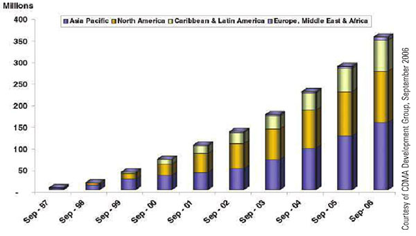
Figure 1. Global CDMA subscribers. CDMA cellular infrastructure uses GPS for synchronization and optimal performance. Location-based billing will require GNSS integrity.
By Vidal Ashkenazi
The use of satellite navigation in civil aviation and other safety-critical navigation applications drove the development of satellite-based augmentation systems and differential networks to track and augment GPS, providing the prerequisite levels of accuracy, integrity, coverage, and availability. Deployment and operation of Galileo — independent, compatible, and interoperable with GPS — will significantly add to the levels of accuracy, coverage, and system integrity.
Meanwhile, safety-critical transportation is no longer the only critical application considered for satellite navigation and positioning. New and developing financial-critical, business-critical, security-critical, legal-critical and government- policy-critical applications demand levels of coverage, integrity, and availability matching those of safety-critical transportation.
Consider road user charging (RUC) proposed by the British government to replace the current fixed annual road tax, which only depends on a vehicle’s size and pollution rating. RUC is based on taxing a car owner who drives only on country roads less than another driver who uses city centers and motorways, often during rush hours, contributing to traffic jams and pollution. It would be fairer if road taxing were based on when, where, and how you drive. The same principles also apply to car insurance and city-center congestion charging.
So far, all seems straightforward. But consider that with direct telematic links to individual bank accounts, these charges could be debited automatically, or invoiced and debited like monthly utility bills. Once money is involved, the operation becomes financially-critical. There is a need to demonstrate that such charges not only have high accuracy and integrity, but that they are “correct, beyond all reasonable doubt”.
As a scientist and an engineer, I have always used the terms “statistical levels of accuracy and integrity.” This is the first time in my scientific life that I have to use that statistically meaningless, unspeakable term “correct”, which implies 100 percent of certainty. GNSS, this is your challenge!
The same is true of the timing of stock exchange transactions and location-based billing via mobile phones. As the levels of accuracy, coverage and integrity of GNSS improve, so will the credibility of satellite positioning as a highly accurate, reliable tool for economically-critical applications.
It is difficult to distinguish between security-critical and legal-critical navigation and positioning applications. Both types will require very high levels of accuracy, coverage, and integrity, but most applications that start as security-critical may end up in a court of law and become legal-critical. Examples include tracking precious or hazardous cargos, tracking suspected individuals or criminals released on parole, the location of suspect mobile phone calls, and the positioning of fishing vessels inside territorial waters.
Lastly, many government/policy-critical navigation applications connected with police, fire and ambulance services, national security, and emergencies will require secure/encrypted GNSS signals. In the United States, where GPS is directed by the PNT Executive Committee, co-chaired by the DoD and the DoT, this should not present a problem, because the system is considered a fully dual military-civilian navigation tool. This is not the case in Europe, which has yet to define the framework for governance and use of the Public Regulated Service within EU member states, and the status of non-EU states proposing to collaborate on Galileo.
VIDAL ASHKENAZI is CEO of Nottingham Scientific Ltd., a UK-based company involved in Galileo since its earliest phase. He is a charter member of GPS World’s Editorial Advisory Board since 1990. This article is excerpted from his keynote address at IAIN World Congress 2006 held in Korea.