A free 12-day online course on GNSS will be offered by the Indian Institute of Remote Sensing (IIRS), part of the Indian Space Research Organization (ISRO).
“Overview of Global Navigation Satellite System” (Course-ID: 107) will be held Sept. 19-30. The course is designed to help with the urgent demand for trained manpower in remote sensing, geographic information systems (GIS), GNSS and associated geospatial technologies. The course will introduce GPS and GNSS, receivers, processing methods, errors and accuracy.
The course will cover the following topics:
GPS receivers, processing methods, errors and accuracy
satellite-based augmentation systems and GPS-aided and GEO-augmented navigation (GAGAN)
GPS signal characteristics and data formats (broadcast and precise ephemeris)
Indian Regional Navigation Satellite System (IRNSS)
DGPS demonstration
advanced GNSS processing
development of satellite navigation technology, TRANSIT, TSKLON, GNSS (GPS, GLONASS, Galileo and BeiDou), principles of GNSS, segments and applications
satellite navigation.
The course is open to undergraduate and postgraduate students; technical or scientific staff of central or state government; and faculty or researchers at university or institutions.
Course study materials — lecture slides, recorded video lectures, open-source software and handouts of demonstrations — will be made available through the IIRS learning management system E-CLASS.
The latest chapter of the decades-long Lightsquared/Ligado saga will be revealed this week
The National Academies of Science, Engineering and Medicine (NASEM) will hold a public online briefing at 11 a.m. ET on Sept. 9 to present the results of its Ligado interference study. The committee’s report will be available at National Academies Press at that same time.
The decision by the Federal Communications Commission (FCC) to grant Ligado Networks permission to operate a terrestrial service in a frequency band adjacent to that used by GPS has been controversial since it was announced in April 2020.
The Executive Branch has formally objected to the decision because of its potential to interfere with various kinds of GPS receivers and requested its reversal. So have numerous industry groups.
The satellite communications company Iridium and some weather organizations also formally objected.
Seven different “Petitions for Reconsideration” were filed with the FCC in May 2020 reflecting a variety of engineering- and process-based objections. None have been acted upon and all are still open issues for the commission.
As a result of the long dispute over the potential for interference, the National Defense Authorization Act for 2021 required the Department of Defense (DOD) to contract with NASEM to examine the issue. The study effort began almost exactly a year ago with the announcement of a proposed study team.
According to the NAESM website:
This study will review Federal Communications Commission order FCC 20-48, which authorized Ligado Networks LLC to operate a low-power terrestrial radio network adjacent to the Global Positioning System (GPS) frequency band. It will consider how best to evaluate harmful interference to civilian and defense users of GPS, the potential for harmful interference to GPS users and DOD activities, and the effectiveness and feasibility of the mitigation measures proposed in the FCC order.
Specific results were intended to include:
which of the two prevailing proposed approaches to evaluating harmful interference concerns — one based on a signal-to-noise interference protection criterion and the other based on a device-by-device measurement of the GPS position error — most effectively mitigates risks of harmful interference with GPS services and DOD operations and activities
the potential for harmful interference from the proposed Ligado network to mobile satellite services — including GPS and other commercial or DOD services, and including the potential to affect DOD operations and activities
the feasibility, practicality and effectiveness of the mitigation measures proposed in the FCC order with respect to DOD devices, operations and activities.
Other relevant issues the study committee found are also expected to be discussed.
The NASEM committee has been meeting regularly since the end of September 2021 and has heard from numerous industry and interest groups on both sides of the issue. Materials presented as well as videos of the public portions of all the meetings are available at the group’s website.
Both a classified and an unclassified version of the report are supposed to be produced. No information has been released about whether the classified report has been completed and provided to the Department of Defense.
Based on previous NASEM reports, some observers predict the results of the study will not strongly support either side of the dispute. “Most of these kind of reports say, ‘On the one hand this, but on the other hand that.’ Usually they are not really conclusive. I expect both sides will find something in it to support their assertions and the dispute will continue as it has to date,” said one stakeholder.
GNSS researchers are presenting hundreds of papers at the 2022 Institute of Navigation (ION) GNSS+ conference, taking place Sept. 19–23 in Denver, Colorado, and virtually. The following five papers focus on GNSS receiver technology and interference mitigation. The papers will be available at www.ion.org/publications/browse.cfm.
The growing dependence of critical and safety-of-life systems on GNSS makes the ability to rapidly detect and localize the presence of GNSS interference events increasingly important. Ground-based GNSS jammer detection can be used to detect local interference sources. However, this approach is limited by line of sight, hence applying it to large areas is costly in both time and money.
A complementary technique is to use the airborne GNSS receiver data provided by Automatic Dependent Surveillance—Broadcast (ADS-B). As these receivers are at altitude, their lines of sight can cover a wide area. The drawback is that ADS-B was not designed for this purpose, and the messages contain limited information for the assessment of interference.
The authors have developed and will demonstrate an algorithm for real-time detection and localization of GNSS interference sources using ADS-B transmissions on the 1090 MHz (Mode S ES) radio frequency channel. They demonstrate this capability using recorded ADS-B transmissions from known interference events.
Zixi Liu, Sherman Lo, Todd Walter, Juan Blanch, Stanford University; “Real-time Detection and Localization of GNSS Interference Source.”
Even interference at low levels can be catastrophic to systems that depend on GNSS. It can prevent GNSS signals from reaching the user (interference or jamming) or give false signals, resulting in an incorrect position and time solution (spoofing). The capability to confidently detect and localize interference quickly could help mitigate this threat. Furthermore, if the system could also provide information characterizing the interference, it could help law enforcement not only interdict, but also prosecute the threat.
Building a consumer-level commercial-off-the-shelf (COTS) GNSS monitor would also make it cost effective for widespread utilization. This paper describes the development and field testing of a system to provide this capability.
The monitor uses the u-blox F9, an inexpensive commercial receiver offering multi-constellation and dual-frequency position and time solutions, as well as powerful interference-detection metrics. Initial analysis of the receiver’s measurement capabilities determined that it provides many features useful for assessing the operational environment across a geographical region. Performance and output of the receiver is characterized under different jamming and spoofing scenarios.
Different receivers and antennas may react differently based on both hardware and software configurations and offer the user varying interference rejection techniques and detection metrics. As a result, it is important to gain a good understanding of the receiver’s behavior. Another way to test behavior is to examine its performance in nominal conditions in various scenarios and locations, as presented in this paper.
Benon Gattis, Dennis Akos, University of Colorado Boulder; Yu-Hsuan Chen, Sherman Lo, Todd Walter, Stanford University; “Test and Measurements from a Global Navigation Satellite System (GNSS) Monitoring System.”
GEOLOCATING INTERFERENCE WITH SMARTPHONES
Conference Presentation: Virtual; Session F6
With the availability of RAW GNSS measurements on Android smartphones, detecting GNSS interference using modern handsets has become a realistic crowdsourcing possibility, especially with the inclusion of automatic gain control (AGC) in Android 8 (Oreo).
While crowdsourcing jamming detection — and knowing whether your smartphone is subject to jamming or spoofing — is valuable, locating the interference source may be even more important. This work explores the feasibility of crowdsourcing interference source localization with modern Android smartphones.
The work has three goals:
To examine localization of a civilian-type GPS L1 jammer using a network of smartphones
To investigate how best to approach current obstacles regarding such localization
To estimate how accurate this type of positioning can be.
An important part of this work is to investigate differences in GNSS data reported by various Android smartphones. The smartphones in this study were specifically selected by the manufacturer of the GNSS chipset to enable the authors to examine how their GNSS receivers perform under the same circumstances. Three parameters were specifically investigated as measures of received jamming power: carrier-to-noise ratio (C/N0), AGC and the number of tracked satellites.
The selected smartphones were put through a series of tests to examine how these three parameters vary with changing conditions. These tests include subjecting the smartphones to an actual jammer in a controlled lab setup and an investigation of the impact of smartphone (GNSS antenna) position and orientation on C/N0 and AGC. Using the data collected in these tests, several interference geolocation strategies will be discussed.
The authors also consider whether interference localization from consumer-off-the-shelf (COTS) smartphones is currently accurate enough for this use. The shortcomings of smartphone GNSS hardware may be resolved using more clever positioning strategies such as using a larger number of handsets. Alternatively, it may require upgraded hardware and standardization.
Søren Skaarup Larsen, Daniel Haugård Olesen, Anna B. O. Jensen, Lars Stenseng, Technical University of Denmark, DTU Space; “Assessment of RFI Geolocation Using Modern Android Smartphones.”
Multipath mitigation with machine learning relies on offline training with an exhaustive number of labeled observations. Current super-resolution correlation methods, which include MUltiple SIgnal Classification (MUSIC), operate online by testing and choosing from a high number of candidate signal hypotheses.
A new method of MUSIC is presented that reduces numerical complexity and is applied to processing L5 correlation vectors to reduce multipath by identifying the earliest path. The rank of this estimator is examined in static and dynamic conditions in various signal environments. Higher rank allows more signal paths to be identified.
This method is also complementary with various L5 signal-tracking methods such as open- and closed-loop tracking.
Paul McBurney, Norman Krasner, Florean Curticapean, Miguel Ribot, Mahdi Maaref and Lionel Garin, OneNav; “Application of Super Resolution Correlation to Multipath Mitigation in an L5 Channel.”
One of the simplest ways to increase GNSS anti-jamming and anti-spoofing (AJ/AS) performance is increasing the number of controlled reception pattern antenna (CRPA) array elements. However, this increases the size, cost, complexity and required processing power of the overall system. To counter this constraint, the researchers applied a new development in antenna hardware design to GNSS threat mitigation techniques. This resulted in better CRPA performance without increasing the footprint. The work improves AJ/AS performance without adding additional elements, and serves as proof of concept of the application of an adaptively spaced virtual array created with multimodal elements to GNSS AJ/AS.
New breakthroughs in antenna-array research extend the case of non-uniform excitation of elements to the elements’ individual positions. By using multimodal antennas as elements, it has been shown that elements’ phase centers, or perceived locations, can be adjusted with purely electronic means. When applied to each element in an antenna array, this realizes a reconfigurable array.
This research extends the concept of a virtual array with adaptive inter-element spacing into GNSS AJ/AJ methods. A new way to integrate a virtual array into a GNSS application is explored and incorporated into current space-time adaptive processing (STAP) algorithms.
Gabriel Wiggins and Scott Martin, Auburn University; “Applications of a Virtual Antenna Array to GNSS Threat Mitigation: First Results.”
By Nino De Falcis, Senior Director of Business Development, ADVA
Today’s critical network infrastructure is heavily reliant on positioning, navigation and timing (PNT) services. Power grids, financial markets, transportation, data centers, communications — all have become more complex and interconnected, while the threats to the PNT on which they depend have grown in frequency and sophistication. PNT systems are so vulnerable to the activities of cybercriminals that attacks may soon become global in scale and significance, with potential costs of billions of dollars.
Utilities are a key example of infrastructure at risk. In the past, power networks were passive systems with everything simple and centralized, and with energy flowing in one direction only as AC power was provided to consumers. However, the growth in renewables and distributed energy resources has spurred diversification of the market, and a new paradigm of bidirectional AD and DC energy production and distribution has emerged: the smart grid.
Timing Challenges
Today, many smaller producers are generating power from multiple sources. The power grid has become a decentralized system and the flow of energy is now bidirectional. Energy from solar panels (microgrids), for example, can be generated by private individuals and either stored or fed back into the grid. Electric vehicles (EVs) are also becoming more common, and like all other nodes across the smart grid, charging points require precise timestamping of the massive amount of data they generate to balance power demand and supply.
Precise timing is also key to rerouting power flows away from transmission outages, to locating power line faults, and for synchronizing distributed control and protection systems. Without highly accurate timing and synchronization, power grids are vulnerable to partial outages and even complete blackouts.
That is why accuracy requirements of data timestamping are tighter than ever. In fact, they are shifting from legacy Network Timing Protocol (NTP) timestamping, which has millisecond accuracy needs, to Precision Timing Protocol (PTP) timestamping, requiring sub-microsecond accuracy. The syncrophaser now demands accuracy better than 1 microsecond.
For fault location, we’re now at 100 nanoseconds. The micro-phasor measurement unit (PMU) is at less than 1 microsecond and substation LAN communication protocols have to be time-stamped at as low as 100 microseconds for GOOSE IEC 61850 and at 1 microsecond for IEC 61850 sample values. This is a big change from just five years ago when accuracy in all these categories was firmly in the millisecond range, and it’s a high bar that needs to be maintained by next-generation redundant systems, should GPS or ground-based timing become compromised.
Guidelines for making PNT infrastructure fully redundant are being pushed by governments across the world. In the United States, regulations are being driven by Executive Order 13905 with the Department of Homeland Security (DHS) providing a framework for how assured PNT (aPNT) should operate. It states that PNT infrastructure must perform three core functions: prevent, respond and recover. Infrastructure must have the ability to prevent atypical PNT errors and corruption of PNT sources. If prevention fails, networks must be able to respond to detected errors or anomalies and then recover from those errors.
The DHS framework outlines four resiliency levels. Level 1 has only one source providing PNT, while level 4 is a next-generation system leveraging multiple sources to derive and distribute PNT data. At Level 4, systems need to be self-survivable. This means they must function for long periods in the absence of a GPS timing source, or when ground-based timing sources have been otherwise compromised. There is even an IEEE P1952 resilient PNT standard in progress that will use this DHS framework.
Rising Threats
There are two categories of threat to PNT: external and internal. External threats include jamming (equipment that can block GPS is available off the shelf for as little as $20) and spoofing, which is the act of transmitting false GPS signals that trick receivers into calculating an erroneous position. Sophisticated cyberattacks can be in the form of either of these and spoofing (especially synchronous) is the most complex to detect.
The two main internal PNT threats come from attacks on NTP and PTP network timing as well as active GPS receivers connected to the network.
Legacy power grids have traditionally used NTP to distribute timing to substations, including IRIG, and this has already shown itself to be vulnerable to attack because it can be hacked by a process called NTP amplification.
Today, power grids are increasingly migrating to PTP because it provides the sub-microsecond accuracy needed for modern applications. PTP also has not yet been hacked, but that does not mean it soon will not be. If an attack did occur on ill-prepared critical infrastructure, the results could be catastrophic.
Secure Smart Grid Timing Components
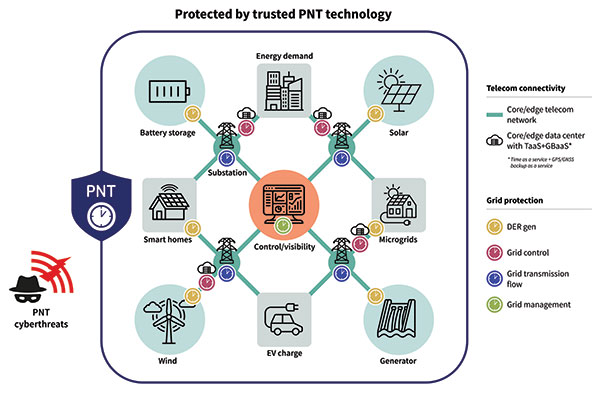
There are two components in the smart grid: telecom connectivity to transport data, and grid protection that has different level generation grid control, transmission and management. On the telecom side, there is the edge telecom network and sometimes there are data centers. There are either core or edge data centers and these are also equipped with very good timing. A key concept in the data center is time as a service and GPS backup as a service when GPS goes down. The smart grid can also leverage this service as it gives even more robust protection and security against threats to PNT. See Diagram 1.
Diagram 1. A key concept in the data center is time as a service. (Image: ADVA)
A Resilient and Assured PNT Solution
As with other aspects of cybersecurity strategy, smart grids must employ a zero-trust framework of PNT sources. This approach never assumes that any one PNT source can be trusted. Instead, it uses a multi-source approach, verifying sources and comparing them to each other in real time to get the most accurate timing possible.
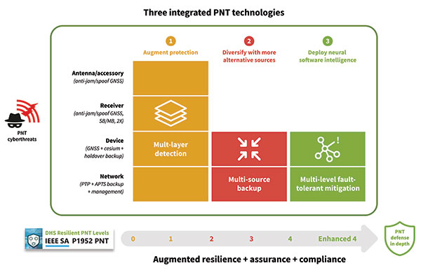
To prevent and mitigate interruptions to GPS, smart grid operators should deploy a resilient and assured PNT solution. This means it’s based around three integrated technologies: multi-layer detection, multi-source backup and multi-level fault-tolerant mitigation.
Multi-layer detection is performed through timing devices – either single or redundant – that have jamming and spoofing detection and monitoring capabilities. GNSS devices are also capable of comparing sources such as network PTP timing and they can be equipped with standalone, GNSS-backup clocks that leverage rubidium or cesium oscillators to obtain the most reliable timing information from other timing sources in the network.
Multi-source backup comes in the form of a cesium or rubidium oscillator that can provide extended holdover. Backup can be further bolstered with other sources such as eLORAN, NIST and LEO.
A neural network management system is an intelligent platform that ties everything together, from self-actionable recovery and assurance software to alerting users of issues in the network-wide timing infrastructure. It provides visibility and control of all aspects of prevention, mitigation and backup. The management system gives detailed operational data on the smart grid, showing the locations of the faults, the types of faults, and how PTP backup assurance is performing. Through capabilities powered by artificial intelligence and machine learning, the management and control system provides the end-to-end control, visibility, and trusted, assured PNT. It has all the intelligence to reveal threats and also take action against them, quickly recovering the network’s timing distribution capability, while keeping the network timing self-survivable. See Diagram 2.
Mitigating Cyberattacks with a Defense-in-Depth Approach
So, let us imagine there is a major attack on a smart grid. A jamming device has been used to block GPS reception on an edge grandmaster being used at a substation, while at the core of the network an ePRTC’s ability to receive GNSS signals has also been compromised. GPS is no longer viable as a source for timing in the smart grid.
The intelligent software monitoring and management system is the first line of defense, detecting and alerting operators to the two or more attacks on GPS: one at the core of the network and one at the substation. The network timing capability of the whole smart grid has been compromised.
Upstream from the substation, the core enhanced PRTC (ePRTC) has become an unreliable source of timing. However, it is equipped with a cesium clock that steps in to propagate trusted PNT backup into the substation and throughout the rest of the network. The cesium clock has no antenna, no RH signal, and is a stratum 1 clock that can propagate highly accurate timing (accurate to 1 microsecond over four months) throughout the network. It has now become the trusted source of timing until GPS can be re-established.
The most crucial element of PNT is timing. Without timing there is no positioning or navigation — it is the enabler of both — and so the distribution of accurate timing must be our top concern when we build systems.
For smart grids and all other critical infrastructure dependent on PNT to function, the cornerstone for secure and self-survivable timing networks is the concept of zero-trust. A multi-source approach to building timing networks will allow operators of critical infrastructure to leverage a combination of intelligent management software and timing devices equipped with adequate PTP holdover to respond to all threats to PNT.
To see a real-world example of this approach in action, check out the DOE DarkNet program.
“Seen & Heard” is a monthly feature of GPS World magazine, traveling the world to capture interesting and unusual news stories involving the GNSS/PNT industry.
3D mapping is helping forensic teams reconstruct fatal traffic accidents in Singapore, reports The Straits Times. In 2021, Singapore had 100 fatal road accidents. Experts use 3D replicas of the accident site and simulation models to recreate events leading to an accident and its aftermath. This helps forensic scientists determine whether the vehicles were speeding or flouting traffic rules. The National 3D Mapping Program of the Singapore Land Authority has mapped every road, lane and highway in Singapore with a 3D laser scanner and car-mounted cameras, and plans to update the maps regularly. Autonomous vehicles will also depend on the 3D point-cloud data.
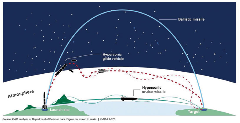
Diagram: U.S. General Accountability Office
BeiDou Enables Hypersonic Flight
In simulation drills using BeiDou, Chinese space scientists flew a hypersonic flight from Jinan, China, to New York over the Arctic Ocean, reports EurAsian Times. BeiDou facilitated contact between the command center on Earth and the hypersonic vehicle as it dodged enemy air defenses. Researchers claim using BeiDou provided a time lag of less than a second. They also claim to have optimized signal transmitters and designed new satellite-jumping methods to overcome communication challenges. China and Russia are the only countries with operational hypersonic weapons — Russia has used its Kinzhal hypersonic missile in the Ukraine war.
Indonesia’s National Research and Innovation Agency (BRIN) and Dr. Soetomo University are cooperating on aerial photo mapping using an unmanned aerial vehicle and GNSS hardware. BRIN’s Ocky Karna Radjasa said he expects that the two parties will extend the opportunity to advance research and innovation as well as bolster the quality of education in Indonesia. The university’s Nur Saidah expects BRIN’s support will increase, stating, “We still have limitation in laboratory facilities, so we seek industry cooperation. Let us hope that, as a result of this cooperation, we can receive help.”
A new navigation system addresses shortcomings of GNSS using cosmic-ray muons. Muometric navigation enables positioning underground, indoors or underwater within a reference coordinate system defined by the 3D positions of multiple detectors, researcher Hiroyuki K. M. Tanaka explains in the June issue of Nature. Tanaka’s work shows the system offers a navigation quality almost equivalent to aboveground GPS-based handheld navigation by determining the distance between the reference frame and the receivers with a precision of 1 to 10 meters.
The Canadian Positioning, Navigation and Timing Office (PNTO) is warning stakeholders that Ligado has asked the Canadian government for access to spectrum that neighbors that of GNSS services. The request has long been a major issue in the United States because of the risk of radio frequency interference for GNSS users.
Image: da-kuk/E+/Getty Images
Innovation, Science and Economic Development’s (ISED) Spectrum Management and Telecommunications team announced on Aug. 19 a Notice of Application from Ligado Networks. The application seeks authority for providing terrestrial mobile services in the L-band (1526-1536 MHz in the MSS downlink, and 1627.5-1637.5 MHz and 1646.5-1656.5 MHz in the MSS uplink).
In its application, Ligado Canada is requesting that ISED adopt similar operational requirements and technical rules as those of the U.S. Federal Communications Commission. The rules are spelled out in 2020 FCC order 20-48, “FCC Ligado Amendment to License Modification Applications.” The operational requirements would allow Ligado Canada to provide ancillary terrestrial mobile services over specific portions of its licensed MSS spectrum.
Interested stakeholders can submit comments until Oct. 18 on ISED’s website. Respondents are requested to email their comments in Microsoft Word or Adobe PDF to [email protected].
CANSPACE Listserv is a service of Canadian Space Geodesy Forum and is administered by Dr. Richard Langley.
In early August, the U.S. Government Accountability Office (GAO) released its third report in 15 months about GPS and other positioning, navigation and timing (PNT) issues within the Department of Defense (DOD). Each report raised raised concerns about the way in which PNT programs were being managed and led within the department.
Observations included that DOD continues to rely heavily on GPS despite known vulnerabilities. Also, that alternate PNT efforts are not well coordinated and receive little support.
“Opportunities” for DOD to improve its alternate PNT efforts, according to the report, include:
Improving coordination across the services
Clarifying authorities and responsibilities for prioritizing needs
Focusing on resiliency versus GPS as the cornerstone of department PNT efforts
Clarifying PNT requirements rather than just defaulting to GPS as “the need”
The report pointed out that M-code has been in development for 20+ years, and that GPS satellites have been capable of transmitting M-code signals since 2005. Also, while there are still program risks, the Next Generation Ground Control Segment, known as OCX, is forecast to be ready to support M-code use by 2023.
OCX has experienced severe cost overruns and is more than five years behind its original schedule. GAO issued a report on OCX delays in May 2019.
M-code won’t really be a capability in DOD, though, until user equipment is widely fielded. That will take several more years, according to GAO.
One of the remaining challenges to M-code implementation, GAO said, was that the department did not collect and validate all the data it needed for leadership planning and prioritization.
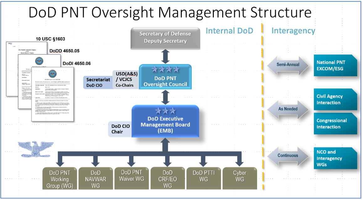
A summary on the first page of the report contains what could be seen as harsh criticism of how PNT efforts are led within DOD:
“DOD’s overall PNT portfolio is managed by the PNT Oversight Council, a statutorily established senior-level body. However, the Council has largely prioritized modernizing the existing GPS system over alternative PNT efforts during recent meetings and has no strategic objectives or metrics to measure progress on the alternative efforts.”
Image: DOD
Too Much Leadership?
Some believe the real problem with DOD PNT is not a lack of leadership, but rather too much.
“If everyone is in charge, no one is,” commented one retired senior military officer familiar with the issue.
“Congress has been concerned about DOD’s lack of attention to GPS and PNT alternatives for years,” the individual said. “In 2015 Congress mandated creation of the Oversight Council to help ensure PNT got the right amount of leadership attention.” This may have not had the desired effect, though.
“The council is comprised of three undersecretaries, the vice chairman [of the Joint Chiefs of Staff], four combatant commanders, the NSA [National Security Agency] director, DOD’s CIO [chief information officer], and host of other very senior folks. All of whom have way too many other duties. It’s no wonder the department has a hard time getting things done!”
The department’s CIO is the Defense Secretary’s Principal Staff Assistant for PNT. As such, the CIO is tasked with coordinating department-wide efforts. The task is made particularly difficult by the many and diverse players across the department, all of whom have their own authorities, interests and projects.
Proposed systems and capabilities are examined and developed by a variety of DOD organizations. These include laboratories belonging to the five services and the Defense Advanced Research Projects Agency (DARPA).
Programs of Record, which usually lead to acquisition of large systems, are led and managed within the individual services.
A Better Way?
Aside from recommending improved coordination of PNT efforts across the department, GAO has never addressed the way DOD manages its PNT enterprise.
“That is not something we normally get into unless specifically tasked,” said one of the reports’ authors. “We assume departments know best how to lead and manage their efforts.”
Others are not so reticent. They believe the current management structure is incapable of managing the development, acquisition and fielding of the DOD PNT Enterprise with any urgency or efficiency.
“GAO’s focus on the Oversight Council is misplaced,” one retired official asserted. “The missing piece is not oversight, it’s day-to-day DOD-wide management.”
“They need a multi-service program of record for resilient PNT,” the official said. “This would be separate from the GPS program, which would keep its own projects going and feed into the resilient effort. The new resilient PNT program should be managed by a Joint Program Office, which could consolidate integration and acquisition of resilient PNT applications. The office would be the steward for the critical technologies that underpin the modular, open-system integration strategy, including the digital reference architecture, input and output standards, software fusion engines, and needed modeling and simulation tools to ensure NAVWAR compliance.”
Such a construct could provide needed focus and coordination to DOD efforts, address many long-standing congressional concerns, and, by coordinating efforts within DOD and with industry, accelerate progress.
Dana A. Goward is President of the Resilient Navigation and Timing Foundation. He serves on the President’s National Space-based Positioning, Navigation, and Timing Advisory Board.
A bipartisan group of eight U.S. senators has sent a letter to the Federal Communications Commission (FCC), urging the agency to stay and reconsider the Ligado Networks order.
U.S. Senators Jim Inhofe (R-Okla.) and Jack Reed (D-R.I.), ranking member and chairman of the Senate Armed Services Committee, led the group in sending the letter to FCC Chairwoman Jessica Rosenworcel, urging her to reconsider granting Ligado’s license modification request.
Ligado wants to use a part of the communications spectrum in a way that risks interference with GPS reception, a move that has been decried by many industry insiders as well as other government agencies, including the departments of Defense and Transportation.
The timing of the letter is critical, as Ligado has announced its intention to deploy a terrestrial network as soon as Sept. 30. The National Academy of Sciences plans to release a report on the FCC’s order at a public online briefing at 11 a.m. ET Sept. 9. The report will be available at National Academies Press at that same time.
Imminent Risks
Joining Inhofe and Reed were Sens. Tammy Duckworth (D-Ill.), Mazie Hirono (D-Hawaii), Mark Kelly (D-Ariz.), Mike Rounds (R-S.D.), Kyrsten Sinema (D-Ariz.) and Dan Sullivan (R-Alaska).
The senators write: “Staying and reconsidering the Ligado Order is necessary to address the imminent risks associated with Ligado’s intention to ‘commence operations in the 1526-1536 Mhz band on or after September 30, 2022.’ We remain gravely concerned that the Ligado Order fails to adequately protect adjacent band operations — including those related to GPS and satellite communications — from harmful interference impacting countless military and commercial activities.
“We urge you to set aside the Ligado Order and give proper consideration to the widely held concerns across the Executive Branch, within Congress, and from the private sector regarding the expected impact of the Ligado Order on national security and other systems,” the senators continued.
We write to you today to urge the Federal Communications Commission (FCC) to stay and reconsider the FCC’s order granting the applications of Ligado Networks LLC (Ligado) to deploy a terrestrial wireless network in the L-band satellite spectrum neighborhood, FCC 20-48, adopted April 19, 2020 (the Ligado Order). We remain extremely concerned that terrestrial L-band operations would cause unacceptable risk to Department of Defense (DOD), the Federal Government Global Positioning System (GPS), and Satellite Communications (SATCOM) operations.
Prior to the issuance of the Ligado Order, fourteen federal agencies and departments expressed strong opposition to the applications sought by Ligado over concerns about potential harmful interference with GPS operations. In May 2020, shortly following the issuance of the Ligado Order, on behalf of the executive branch, the National Telecommunications and Information Administration (NTIA) petitioned the FCC to reconsider its decision. That filing requested that the FCC “rescind its approval of the mobile satellite service (MSS) license modification applications” granted to Ligado, which the NTIA asserted would “cause irreparable harms” to federal government GPS users.
Staying and reconsidering the Ligado Order is necessary to address the imminent risks associated with Ligado’s intention to “commence operations in the 1526-1536 Mhz band on or after September 30, 2022.” We remain gravely concerned that the Ligado Order fails to adequately protect adjacent band operations—including those related to GPS and satellite communications—from harmful interference impacting countless military and commercial activities. We urge you to set aside the Ligado Order and give proper consideration to the widely held concerns across the Executive Branch, within Congress, and from the private sector regarding the expected impact of the Ligado Order on national security and other systems.
We look forward to continuing to work with you to ensure that federal spectrum policy adequately protects the millions of military and commercial users who rely on L-band satellite services every day.
The 62nd meeting of the U.S. government’s Civil GPS Service Interface Committee (CGSIC) will be held Sept. 19–20 in the Hyatt Regency Denver at the Colorado Convention Center, before the annual ION GNSS+ conference.
It will be hosted by the U.S. Department of Transportation (DOT) and the U.S. Coast Guard Navigation Center (NAVCEN). DOT serves as the civil lead for GPS and chairs the CGSIC in this capacity. NAVCEN is assigned duties as Deputy Chair and Executive Secretariat for the CGSIC.
On Sept. 19, the CGSIC subcommittees for Timing, International Information, and Survey, Mapping, and Geosciences will meet. A summary of these meetings will be presented to the CGSIC Plenary Session on Sept. 20.
Cordell DeLaPena, Program Executive Officer for Military Communications and PNT Space Systems Command
Keynote speaker for the plenary session is Cordell DeLaPena, program executive officer for Military Communications and Positioning, Navigation, and Timing, Space Systems Command, Los Angeles Air Force Base.
The agendas for the CGSIC subcommittee and plenary sessions will include presentations on the operational status and modernization of the GPS constellation of satellites, U.S. space-based positioning, navigation and timing (PNT) policy, GPS augmentation systems, and information related to U.S. engagement with other international GNSS as well as a variety of interesting applications of the use of GPS.
Several new briefings are part of the plenary session this year, including a presentation from NASA on the role of GPS in support of the next lunar mission. Also, the Department of Homeland Security will provide an update on the activities of the Office of Infrastructure Protection, Positioning, Navigation, and Timing Program Management Office.
This year’s meeting will be live-streamed over the internet. For those who are unable to travel, the meetings can be accessed with the links below.
The agenda for the meeting is available; all CGSIC presentations will be available there for viewing online shortly after the meeting ends. As a reminder, all CGSIC meetings are free and open to the public.
Xona Space Systems, a company developing navigation technologies from low-Earth orbit (LEO), has received investment backing from numerous companies, including Lockheed Martin. Its latest financing round was oversubscribed, bringing the start-up’s total funding to more than $25 million.
Xona is developing a high-performance commercial satellite navigation network, named Pulsar. Pulsar is a LEO system designed to provide resilient and trusted centimeter-level position anywhere on the globe.
Within the past year, Xona more than doubled its number of full-time employees, launched its first orbital mission, and signed agreements with major players across the GPS/GNSS ecosystem such as Hexagon | NovAtel and Spirent Federal.
Image: Xona Space Systems
The funding round was led by First Spark Ventures, who is joined by numerous new investors including Lockheed Martin Ventures, SRI Ventures (of SRI International), Velvet Sea Ventures, Gaingels, Airstream Venture Partners and Space VC. Existing investors also continue to show firm conviction in Xona’s accomplishments and market opportunity with participation from Seraphim Space, Toyota Ventures, 1517 Fund, MaC Venture Capital and Stellar Ventures.
The new capital will accelerate development of Pulsar through several critical design milestones by expanding the team and building out Xona’s new R&D and manufacturing facility in Burlingame, California. This will enable more rapid design cycles and prepare for production.
Xona’s first demonstration mission, Huginn, was successfully launched in May, and its second mission, Muninn, is planned to launch in 2023.
Xona Engineer Nick Manglaviti setting up hardware-in-the-loop testing at Xona’s R&D lab in San Mateo, California. (Photo: Xona Space Systems)
“Xona’s approach to GNSS is poised to enable a whole new class of robust and reliable solutions in everything from automotive to drones,” said Manish Kothari, managing director of First Spark. “This is a technically challenging problem — a problem the Xona team is uniquely qualified and experienced to address. We are very excited to be part of this journey with them.”
Xona’s core mission is to enable modern technology to operate safely in any environment, anywhere on Earth. To achieve this in industries such as automotive autonomy, drones and aerial mobility, precise knowledge of location and time is critical, and it must be robust against sources of potential interference or degradation. This is driving a need for global infrastructure that can support the demands of these applications as they continue to expand in both capability and geography.
“The massive domain expertise of our supporters in everything from scaling global companies to deep technical knowledge of GNSS is both a validation of our team’s capabilities and a catalyst that has been instrumental in our growth and speed,” said Xona CEO Brian Manning.
“As customer needs evolve, Lockheed Martin Ventures continues to work with companies we believe are on the forefront of emerging technology and that support increasingly resilient, hybrid systems,” said Chris Moran, vice president and general manager of Lockheed Martin Ventures. “We invested in Xona so they can continue to develop and build their commercial system to complement the greater GNSS architecture.”
“The world would look very different today without GPS,” said Xona CTO Tyler Reid. “The ubiquitous robust precision that Pulsar can provide has potential to make the same level of global impact, not only in present and emerging markets, but we believe this global high precision can also enable entirely new devices and apps that we haven’t even thought of yet.”
USSF Lt Col Robert Wray takes command of 2SOPS. (Photo: USSF/Dennis Rogers)
The 2nd Space Operations Squadron (2 SOPS), which oversees the GPS constellation, now has a new leader. Outgoing U.S. Space Force (USSF) Lt. Col. Michael Schriever relinquished command of the unit to USSF Lt. Col. Robert Wray.
The squadron conducted a change of command ceremony at Schriever Space Force Base, Colorado, on July 6, officiated by Space Delta 8 Commander Col. Matthew Holston.
As the new commander, Wray assumes the responsibility of overseeing the daily operations of a unit whose mission is to operate the GPS constellation, which provides global navigation, time transfer, and nuclear detonation detection.
Col. Matthew Holston honors Lt. Col. Michael Schriver for his 2SOPS service. (Photo: USSF/Dennis Rogers)
Galileo Second Generation Batch#1B satellites. (Image: ESA).
Technology multinational GMV has been awarded the NAVGUARD project by the European Commission.
NAVGUARD (Advanced Galileo PRS Resilience for EU Defence) will develop ground and space systems to detect illegal activities on GNSS frequencies and geolocate their sources. It also will build an information-management subsystem together with a user interface to provide a situational awareness picture.
The Galileo Public Regulated Service (PRS) is an encrypted navigation service for governmental authorized users and sensitive applications that require high continuity.
According to the EU Agency for the Space Programme (EUSPA), the PRS signal will ensure better continuity of service to authorized users when access to other navigation services may be degraded (resilience). In cases of malicious interference, PRS increases the likelihood of the continuous availability of the signal-in-space (robustness).
NAVGUARD is among various European Defence Fund (EDF) projects designed to sharpen the competitiveness of the European Union defense industry and strengthen the EU’s strategic autonomy. Besides navigation, the projects contracted to GMV will focus on developing missile defense system capabilities, systems for dismounted soldiers, avionics, command and control and cyber defense.
 A free 12-day online course on GNSS will be offered by the Indian Institute of Remote Sensing (IIRS), part of the Indian Space Research Organization (ISRO).