The 2022 Public Interface Control Working Group and Open Public Forum will take place virtually on Sept. 28, the U.S. Air Force has announced. It is hosted by Space Systems Command, Military Communications and Positioning, Navigation, Timing Directorate.
The following NAVSTAR GPS public documents will be discussed:
IS-GPS-200 (Navigation User Interfaces)
IS-GPS-705 (User Segment L5 Interfaces)
IS-GPS-800 (User Segment L1C Interface)
ICD-GPS-870 (Control Segment [OCX] to User Support Interface).
The virtual meeting can be accessed via the following dial-in numbers and links:
On July 14, the U.S. House passed its version of the National Defense Authorization Act (NDAA) for fiscal year 2023, which begins Oct. 1, 2022.
The report released with the legislation contains several provisions of interest for the GPS and positioning, navigation and timing (PNT) communities. Perhaps most intriguingly, it indicates the National Guard is considering a program to ensure it has one or more sources of time independent from GPS.
Here are some of the more interesting PNT-related mentions in the report.
GPS Disruption & RF-Based Alternatives
A provision entitled “Briefing on Disruption of Global Positioning System” reiterates concerns Congress has expressed repeatedly over the last two decades.
On the civil side, these concerns have resulted in prohibiting the U.S. Coast Guard from disposing of old Loran facilities until a backup for GPS is decided upon and requiring the Department of Transportation to establish a timing alternative to GPS.
Most of Congress’ attention has been focused on the Department of Defense (DOD), though. Over the years, it has tasked the department with a wide variety of briefings and actions including reporting on threats to GPS, how DOD will operate in GPS-denied environments, progress (or lack thereof) in OCX and M-code, and development of alternative PNT systems.
The 2021 NDAA took a more activist approach and required DOD to “generate resilient and survivable alternative positioning, navigation and timing signals.” It also directed the department to work with the National Security Council, the departments of Transportation, Homeland Security, and others “to enable civilian and commercial adoption of technologies and capabilities for resilient and survivable alternative positioning, navigation, and timing capabilities to complement” GPS. The act mandated that this all be completed within two years.
Photo: Andrea Izzotti/Shutterstock.com
The 2023 NDAA reinforces Congress’ long standing concerns about “increasing threats of disruption” to GPS, stating “it is critical to invest in technologies that provide resilient and assured positioning, navigation and timing capabilities…”
Language in that same provision, though, focuses just on alternate navigation capabilities as opposed to full PNT. The act requires a briefing before the end of this year about DOD’s plan across the Future Year Defense Program (FYDP) for “alternative navigation broadcast services.” The briefing is required to include information about “progress on radio frequency-based alternative navigation solutions,” what the department is doing now, and cost estimates for infrastructure and other expenses across the FYDP.
Army MAPS Program
The Army’s Mounted Assured PNT System (MAPS) is focused on ground vehicles. Information on the service’s website seems to indicate the upgrade in the first generation of MAPS is an anti-jam antenna. The overall program of record is more ambitious, according to the site, and includes M-code, other GNSS and inertial sensors.
“Path to ALTNAV” and “Open Standards Interfaces” are also listed as features in the MAPS final version. This is likely incorporation of DOD’s mandate for modular open system architecture to ensure the ability to easily integrate future navigation and timing systems and signals.
The Army is already producing and fielding the Gen 1 version of MAPS. In March 2022, the Aberdeen Proving Ground News announced that 1,000 units had been fielded.
In its report accompanying the NDAA, Congress expressed concern with the pace of the MAPS program. It notes the Army has procured 2,000 units — a small fraction of the 225,000 ground vehicles the service operates.
The text of the congressional report also seems to indicate the program is not much beyond the point described on its website two years ago. The website says a Program of Record technical solution was planned to have been finalized in September 2020.
The House version of the bill would require the Army to provide a briefing on:
technical performance of candidate systems to incorporate into MAPS
the cost of these systems and integration
plans to deploy MAPS to the Army’s fleet of vehicles
plans to upgrade the Gen I MAPS units already fielded.
Another indication of the delayed pace of the program is that this briefing is not due for more than a year, in December 2023.
Autonomy Software for PNT-Denied Environments
While much less specific, another interesting PNT-related provision is a requirement for DOD to “Report on autonomy software for Next Generation Air Dominance.”
It describes a developing Air Force strategy for using piloted and unpiloted aircraft alongside each other. The software “could enable the continued operational capability of systems in positioning, navigation and timing-denied environments.” The Navy and Marine Corps are developing a similar concept.
Photo: Brian Kinney/Shutterstock.com
Little public information is available concerning any of the Next Generation Air Dominance programs or supporting systems. Experts have speculated, though, that operation in PNT-denied environments would likely involve some of the aircraft remaining outside the denied area and providing PNT information to the others via one or more links.
National Guard and Nationwide Alternative Timing
At the end of a section entitled “Collaboration on positioning, navigation, and timing research,” the House report reveals that the National Guard is concerned about relying entirely on GPS for timing and seems to have begun to address that shortfall.
It requires a report no later than February 2023 on the Guard’s “Nationwide Integration of Time Resiliency for Operations (NITRO) effort.” The report should address, among other things, mission need, capability gaps, estimated costs and how the department is collaborating with other federal, state and local entities.
The budget item for NITRO cites malicious cyberattacks that can impact command and control (C2) systems. It says the Guard’s ability to support civil authorities and critical infrastructure is at risk if not mitigated with resilient time.
While attempts to reach the National Guard for comment have been unsuccessful, PNT expert Pat Diamond said the Guard’s concerns and efforts are well justified. “Precision timing is a seriously weak link for everyone in the United States, including critical infrastructure and organizations like the National Guard,” Diamond said. “If GPS timing was not available for some reason, land mobile radios, common operational pictures, the ability to navigate, plus command-and-control systems would suffer greatly, potentially being completely degraded. It’s outstanding that the Guard has realized this and seems to be moving out. All the power to them.”
A Must-Pass Bill
The House version of the 2023 NDAA has yet to be conferenced and reconciled with that of the Senate. While the Senate’s version of the NDAA has been filed, the accompanying report has not yet been released. Since the House provisions seem relatively non-controversial, they are almost certain to be included along with others from the Senate in the final bill and report.
The resulting legislation is almost certain to pass into law.
Congress often struggles to pass even routine legislation. For example, it has only funded the government on time in four of the last 40 years. The annual defense authorization is an exception. NDAA’s are considered “must-pass” bills. Congress has sent one to the president in each of the last 61 years.
Dana A. Goward is President of the Resilient Navigation and Timing Foundation. He is also a member of the President’s National Space-based Positioning, Navigation, and Timing Advisory Board.
ITU is the United Nations agency that deals with information and communications technology. Its remit includes coordinating spectrum use and satellite orbits.
ITU’s Radio Communications Bureau sponsors the World Radiocommunication Conference every three to four years. The issue of interference with GNSS signals was reported at the 2019 conference.
Since that time, according to this month’s circular, the group “has been informed of a significant number of cases of harmful interference to the radionavigation-satellite service…”
Despite concerns expressed by maritime and other interests, the circular focuses entirely on aviation interference. It says the reports it has received have been about “receivers onboard aircrafts and causing degradation or total loss of the service for passenger, cargo and humanitarian flights…” These have included “misleading information provided by RNSS [radionavigation satellite service] receivers to pilots.” An often cited example of this is a well-publicized 2019 incident in Sun Valley, Idaho. In that case a passenger aircraft nearly hit a mountain.
Describing interference with GNSS as a global and recurrent problem, the circular cites data collected by a major aircraft manufacturer. The company found “10,843 radio-frequency interference events … globally in 2021. The majority of these events occurred in the Middle East region, but several events were also detected in the European, North American and Asian regions.”
This year’s uptick in GNSS interference in Scandinavia, the Baltics, and around Ukraine since Russia’s February invasion of Ukraine is not mentioned. This is likely due, in part, to timing. ITU’s Radio Regulations Board met in March 2022 and directed the circular be issued.
Many within the positioning, navigation, and timing community have long asserted that interference with GNSS signals, whether deliberate or accidental, constitutes a violation of ITU rules and regulations. This month’s circular affirms this and cites several applicable provisions.
These include prohibitions on harmful interference with any authorized radio frequency transmission, requirements for users to transmit only in bands for which they have authorization, and for all to generally safeguard aviation operations.
The circular highlights provision 15.1 of ITU’s Radio Regulations as particularly applicable. It states:
“All stations are forbidden to carry out unnecessary transmissions, or the transmission of superfluous signals, or the transmission of false or misleading signals, or the transmission of signals without identification…”
As is the case with almost all international agreements, enforcement of ITU rules is the responsibility of its member states.
While most expect the advisory to have little immediate impact on reducing global interference with GNSS signals, it does help reinforce the issue as one of international concern.
According to a retired government official, “Member states that fail to comply with international rules to which they have agreed lose credibility and standing in the community of nations. Even when they have little credibility or standing to begin with, the behavior adds to their marginalization and life is just a little more difficult for them. This can, in the long run, nudge them toward being more responsible players.”
The American Geophysical Union (AGU) hosts the meeting, which unites the global Earth and space science community to share findings, connect and advance the profession and its benefits for society. The conference generally has more than 25,000 attendees from more than 100 countries
A dedicated GNSS session was successful at the 2021 AGU. This year, the session is:
“As the title promises, it shall become a platform for interactions between people that are using our products and those that are generating them,” the AGU conveners wrote in an email to the CANSPACE Listserv. The conveners are Allison Craddock (IGS CB, Jet Propulsion Laboratory, USA), Felix Perosanz (CNES, France) and Rolf Dach (AIUB, Switzerland).
Of the 60 exhibitors at the Institute of Navigation’s Joint Navigation Conference (JNC) in San Diego this year, 16 make inertial navigation systems (INS). Many of the other exhibitors integrate INS with GNSS receivers or make simulators to test those integrations. Several exhibitors make a variety of other navigation systems, using active and passive optical sensors, wheel encoders and RF systems that map beacons of opportunity. Only seven manufacturers of GNSS receivers were present.
That’s because the conference — which took place June 6-9 and focused on technical advances in positioning, navigation and timing (PNT) — was hosted by ION’s Military Division for the Departments of Defense (DOD) and Homeland Security. “From an operational perspective,” said the conference program, it focused on “advances in battlefield applications of GPS; critical strengths and weaknesses of field navigation devices; warfighter PNT requirements and solutions; and navigation warfare.” In other words, it was mostly on how to navigate in environments in which the use of GNSS is challenged or denied due to jamming.
The conference program told the story of the GNSS/PNT community’s interests and concerns. Several sessions were on complementary PNT using terrestrial RF signals of opportunity, IMUs, geophysical fields (including gravity and Earth’s magnetic field), celestial objects, ground vision and new commercial sources of space-based PNT, such as satellites in low Earth orbit (LEO).
Other environments in which reliance on GNSS is hard or impossible — such as urban canyons, deep inside buildings, underground and underwater — pose the same navigation challenges to both military and civilian applications. Likewise, jamming is a threat to both. Therefore, several sessions focused on critical infrastructure, demonstrating that the concerns about GNSS vulnerabilities are not just military ones.
Hence the presence among the exhibitors of three manufacturers of atomic clocks, which continue to shrink in size, weight, power and cost (SWaP-C) and are used to assure holdover — that is, the time period required to keep networks synchronized when their primary timing source, usually GNSS, is disrupted or temporarily unavailable. Networks affected include cellphone providers, radio and television broadcasters, financial networks, and the biggest network of all, the Internet.
The JNC “experienced record attendance in both conference participants and exhibitors, hosting more than 1,000 attendees,” Lisa Beaty, ION executive director, told me. She attributed the increase to “the importance of PNT in the nation’s critical infrastructure, current innovation, programmatic funding, and the desire by the DOD community to collaborate and reconvene.” She confidently anticipates additional growth next year.
I am equally confident that much of the cutting-edge technology on display at this conference will find its way into civilian applications in the next few years. Whether in war or in urban canyons, GNSS navigation faces some of the same challenges.
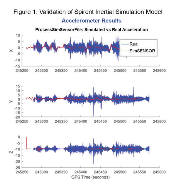
Data shows how successful baseline validation testing of Spirent’s inertial simulation model as compared to real world inertial system performance. Photo: Spirent Federal Systems
We discussed complementary PNT with Roger Hart, head of engineering and Jeff Martin, head of sales at Spirent Federal.
What are some of the most promising approaches to complementary PNT sources and how does simulation technology help?
Roger Hart: The vulnerabilities of GNSS have been recognized. Legacy GNSS are all operating on pretty much the same frequencies and power levels, so, they have some significant common vulnerabilities. There is great interest in finding ways to complement or even replace those capabilities.
Dead reckoning, magnetic and inertial systems have been around for a long time. There are emerging markets to make use of alternative radio frequencies for navigation. In some cases, we are piggybacking on communications signals and deriving PNT from them. In other cases, we are using new PNT signals. A couple that we’ve been focusing on are the alternative navigation systems.
They may be using different orbits, different frequencies, different encoding schemes that set them apart from the legacy GNSS systems, so that, used together, they provide greater resiliency and even stand alone when one or the other system may be affected by interference.
Not to be forgotten is inertial navigation. It’s been around for a long time and is still a standard of navigation. Together with GNSS, it makes it a terrific navigation system. It almost defines complementarity because where GPS is vulnerable inertial can fill in the gaps and where inertial drifts GPS does not. So, paired, they make a very strong system.
At Spirent, we’ve been working with customers to provide a variety of options for both those alternative navigation systems and inertial. Both are a very active field of development and we’re keeping abreast of that.
Jeff Martin: Some good points, Roger. This is something we’ve been engaged in for quite a long time. Since we provide test equipment to the community, it’s critical that we understand what they’re worried about, what the vulnerabilities are. It keeps things exciting, it keeps us on our toes and looking ahead to what’s coming.
What are some of the remaining challenges of integrating GNSS receivers with inertial sensors and, again, how does simulation technology help with that?
Hart: Inertial works by integrating sensor measurements that come in. Therefore, any errors that are present just accumulate over time and can corrupt your navigation solution. So, there’s a strong focus on updating error models and on translating them so that everyday users can use them and get real-life-type performance out of them.
There’s a tendency to think of integrating GPS-INS as putting everything together in one box. There are packages that do that. However, the push now is to go to more distributed systems that are integrated but not packaged in the same box. One example is the all-source positioning and navigation standard that is being developed by the Department of Defense. It will allow you to swap one sensor for another as long as they adhere to the standard. That information all goes back to a sensor fusion engine.
Martin: We have known GNSS simulators well for about four decades. We have been playing in the inertial sandbox for at least a couple of decades as well. This has given us the opportunity to build relationships with the with the key manufacturers and designers of inertial systems. Those relationships have been expanding well beyond inertial to many other sensors and systems that are now coming online. It’s been exciting.
Much work is going into using low Earth orbit satellites for PNT—whether piggybacking on the Iridium satellites or launching new ones. How does simulation help with that?
Hart: It certainly helps with the development of the receivers. The groups that are using these alternative RF and LEO or MEO systems need simulation as they develop the receivers. It gives you the ability to try things certainly before you launch them. At this conference there is considerable interest in making things reprogrammable. We have the NTS-3 satellite, which will be running experiments for different waveforms that can be generated. Even M-code is a step in the direction of giving more flexibility to the signal. It has a lot more flexible cryptography and signal generation than the legacy system with the C/A and P/Y codes.
Our simulation platforms are software based, so we can generate and receive data that can be useful for developing software-defined receivers. It gives you the opportunity to try different waveforms. We have already delivered a satellite-based alternative navigation system simulator. Now, we can build on that one to help the other Leo constellations as they come forward.
Martin: Roger put it well. This is where things get fun. People are concerned with PNT vulnerabilities, so we’re seeing these alternative navigation solutions coming forward. Spirent has done a good job over its nearly 40 years of existence of manufacturing and designing its own hardware and software. It has given us the opportunity to respond quickly. These things are coming fast. People need solutions quickly. We have some solutions already and the platform that we have created gives us the flexibility to develop more. We’re seeing more and more ideas come to fruition and people need to test them. So, this is where it gets fun. We’re excited.
Much work has gone into addressing the enduring challenge of urban canyons. How does simulation technology help?
Hart: Urban canyons are the worst nightmare for GNSS signals. If you’re surrounded by tall buildings, signals are blocked. You may have few or even no satellites in a direct line of sight and many multipath reflections. So, diminished and corrupted signals are available to you. Of course, the more GNSS satellites you have, the better chance you have of getting good signals. But complementing that are radar and vision systems. Those are the ones that will stand out, particularly the vision systems that can read the street signs, see where the curb is, look for parked cars. All those kinds of things will help fill in when you have poor GNSS coverage.
You can observe what’s going on in the environment and simulate it. You can also use our forecasting tool to look ahead.
Martin: This is where things get exciting, isn’t it? In these terrible environments where GNSS is contested—whether it’s an urban environment or one with intentional jamming—there is a lot we can do to help our industry. When this happens in real life, it’s bad news. But when you create that scary situation in the controlled environment of a laboratory, it is great. You can pick things apart and see where you need to improve. I get excited about it. It’s probably the geek in me. It gives us and our partners a lot to look forward to.
How does simulation technology help with sensor fusion?
Hart: It definitely helps you put all the pieces together. You can’t know how your system will work by individually testing each piece. System is the key word here. Simulation enables you to generate the signals and bring them together into a sensor fusion engine. You can test different algorithms. It’s certainly much cheaper and quicker than trying to build this into a product and then test it. Over the decades, simulation has proved itself as a very valuable way in both basic development and integrating the final product.
Martin: That system-wide fusion is where the magic happens.
It sounds like simulation technology—and Spirent Federal in particular—are very much at the center of a lot of the current developments and discussions about complementary PNT. Do you have any final comments?
Hart: As Jeff said, it’s an exciting time. There are many things going on—new technologies, new ways of communicating. It’s a busy time and a bit of a scramble sometimes to keep up with all the new things that are coming.
Martin: People look to Spirent to be their testing resource and it puts us right in the middle of it.
Europe’s leading companies and research institutes working on positioning, navigation and timing (PNT) technologies met in the Netherlands in mid-June for this year’s NAVISP Industry Days. The event is devoted to the latest developments in the Navigation Innovation and Support Program (NAVISP), sponsored by the European Space Agency (ESA).
NAVISP is focused on navigation technologies beyond Galileo and EGNOS, with many of the same engineers that led the development of Europe’s own satnav constellation working with European industry and academia on exciting new concepts.
Photo: ESA
About 130 people participated in the two-day event, which took place June 16-17 at the ESA-ESTEC center in Noordwijk aan Zee, The Netherlands.
As well as attending presentations on NAVISP projects, participants had the opportunity to meet and talk shop in the exhibition area, which displayed products and hardware such as an improved-accuracy smartphone board and drones for data gathering.
The PNT sector accounts for 10% of the European economy.
Throughout Industry Days, the importance of innovation for competitiveness was highlighted, to enable companies to adapt to rapid technological change in the fast-growing PNT sector, which today accounts for 10% of the European economy.
“NAVISP’s strength lies in supporting all types of actors, from start-ups and SMEs to large enterprises, and space companies to companies in other sectors that have recognized the added value of PNT solutions,” said Pierluigi Mancini, NAVISP program manager. “That means playing a part in advancing research and product development, as well as commercialization to broadly foster and support European industry in addressing technology, market and regulatory risks.”
At the Industry Days, many different projects across varying market areas along different points in the value chain were highlighted such as air mobility testbeds, new technologies for roads and other infrastructure, support for maritime navigation, development of novel PNT satellites, studies for quantum-based PNT, and weather monitoring based on collaborative crowdsourcing.
The innovation potential of NAVISP activities was underlined by the fact that two new Navigation Directorate programs set to be proposed to ESA’s Council of Ministers this November — the in-orbit demonstration of low-Earth orbit PNT services and the GENESIS mission for precision Earth measurement — originated in NAVISP projects.
The entire set of the NAVISP Industry Days presentations can be found here.
Manuscripts submissions are being sought for a special issue of Applied Sciences, which will be dedicated to “Recent Advances in GNSS High-Precision Positioning and Applications.”
Deadline for manuscript submissions is Dec. 30. Full instructions are available on the special issue website.
The goal of the special issue is to highlight recent developments in high-precision GNSS positioning models, algorithms and applications. The topics of interest include, but are not limited to, the following:
multi-GNSS multi-frequency PPP, RTK, PPP-RTK models and algorithms, making use of high-grade and low-cost equipment
quality characterization of smartphone GNSS observations
functional and stochastic models for multi-GNSS precise positioning with smartphones
characterization and handling of multi-GNSS inter-system and inter-/intra-frequency code and phase biases
ionospheric and tropospheric modeling
carrier-phase ambiguity resolution
GNSS-LEO observation modeling and integration
integrity monitoring
GNSS-based lunar navigation
satellite orbit dynamics.
Special-issue editors are Safoora Zaminpardaz and Dimitrios Psychas.
Contract signed with EUSPA to develop the next version of EGNOS
Thales Alenia Space, the joint venture between Thales (67%) and Leonardo (33%), has signed a new contract with the EU Agency for the Space Programme (EUSPA) to develop, qualify and deploy the new European Geostationary Navigation Overlay Service (EGNOS) version.
Thales Alenia Space has also just reached a new milestone in the Galileo program with the integration of a new satellite into Galileo’s Ground Mission Segment (GMS) which will improve positioning service for 3.3 billion users.
EGNOS Upgrade
Thales Alenia Space will provide EUSPA and the EU navigation community with a new version of EGNOS (V243). Its operations will be secured by a new state-of-the art Navigation Land Earth Station technology developed by Thales Alenia Space – NLES-G3.
The NLES transmits the EGNOS message containing all accuracy and integrity corrections to the geostationary satellites for broadcast to users such as aviation operators. Thales Alenia Space NLES-G3 will be integrated with a new geostationary satellite, GEO3, which will enhance the EGNOS system and its end-to-end performance.
Certification and commissioning of this latest version is slated for 2024.
Galileo Milestone
Thales Alenia Space also is the prime contractor for Galileo First Generation’s Ground Mission Segment. Galileo has achieved a milestone with the Galileo constellation approaching final steps before its completion with the GSAT0223 satellite. GSAT0223 will increase the operational constellation to 23 satellites for positioning and 25 for search and rescue.
The new satellite has successfully been positioned in orbit and its payload signals inserted in the Ground Mission Segment (GMS) operational chain of Galileo. The GMS is generating the world’s most accurate satellite ephemerids, enabling decimetric ranging accuracy.
With the entry in service of this satellite, the GMS now serves more than 3,3 billion Galileo users who will benefit from an enhanced positioning and timing service.
South Korea has successfully launched a precision aviation satellite Thursday by leasing space on Malaysia’s MEASAT-3d communication satellite for 15 years, reports The Korea Herald. The first satellite for the Korea Augmentation Satellite System (KASS) will improve the accuracy and reliability of GPS signals for pilots, increasing airline flight safety.
The satellite lifted off from Guiana Space Center in Kourou in French Guiana at 6:50 a.m. Thursday (Seoul time), and successfully separated from the rocket at around 7:18 a.m. after the fairing and first stage rocket separations.
In development since 2014, the KASS system can improve the GPS position error to 1.0 to 1.6 meters from the current 15-33 meter level in real time to ensure positioning reliability throughout the country.
The government plans to begin a pilot service around December before its full-fledged operation next year.
South Korea is the seventh country to have a geosynchronous satellite system officially registered with the International Civil Aviation Organization (ICAO). The others are the United States, Russia, China, the European Union, India and Japan.
The Korea Augmentation Satellite System will improve airline safety over Korea. (Photo: ugurhan /iStock/Getty Images Plus/Getty Images)
The EU Agency for the Space Programme (EUSPA) is set to launch a new Fundamental Elements call, with a dedicated online workshop June 30. The workshop is an opportunity to learn about the new call and hear from successful projects funded during the last call.
Fundamental Elements is a research and development funding mechanism designed to support the development of innovative chipset, antenna and receiver technologies in which industry would not yet invest on its own initiative. In doing so, the program helps accelerate the integration of European GNSS (EGNSS) into market-ready devices and solutions.
Projects funded by Fundamental Elements play a key role in EUSPA’s mission of driving the development and market uptake of Galileo-enabled receivers. For example, the GEARS project, which was funded during the initial call, developed a super accurate and highly robust Galileo-enabled receiver capable of providing both time and frequency data for critical infrastructure.
The new Fundamental Elements call builds on success of projects by:
integrating Galileo’s key differentiators into receiver technologies, including OSNMA, high-accuracy frequency, triple frequency, Early Warning Service, CAS and ARAIM
leveraging disruptive technologies such as machine learning and artificial intelligence
exploring potential synergies with Copernicus and the forthcoming GovSatCom.
More details about these points and the call in general will be made available during EUSPA’s upcoming Fundamental Elements online Workshop via Webex. Scheduled for June 30, the workshop will include in-depth information on the funding program and the application process.
The event will also feature project teams funded during the first Fundamental Elements call, who will share their experiences, best practices and advice for putting together a successful project.
Reading her biography, you might not think that Jennifer Wexton, U.S. Representative for Virginia’s Tenth District, would be very connected to technology issues. As an attorney and government leader, she has spent a lot of time advocating for families, veterans and federal workers.
Yet she is also co-founder of the Congressional Task Force on Digital Citizenship and has become an advocate for protecting the nation’s vital positioning, navigation and timing (PNT) services.
“We all use GPS every day whether we know it or not, and we need to ensure it stays the gold standard for satellite navigation,” she said. “But as the National Security Council said last year, it has become a single point of failure for America. So much of our critical infrastructure depends on GPS, from the navigation apps on our phones to the military to our financial and energy sectors, and it is past time that we address its critical vulnerabilities and develop and implement reliable backup technologies.”
Wexton says that she has been aware of and concerned about the issue almost since the day she took her seat in Congress.
“I am a member of the House Appropriations subcommittee that oversees funding for the Department of Transportation, and civil GPS and PNT issues fall squarely in DOT’s jurisdiction,” she said. “In 2018, Congress passed a law requiring DOT to ensure we have a backup for GPS, and we updated that law earlier this year to ensure that all appropriate types of technologies are included in this effort. I don’t know how we can be comfortable with autonomous drones and self-driving cars if we don’t have technologies in place to support and back up GPS. They are certainly available.”
The fact that her district includes a huge swath of Virginia’s high-tech corridor has added to her knowledge of the problem and range of possible solutions. In addition to many big names in technology and government contracting, several smaller companies focusing on resilient PNT have offices in her district. These include Echo Ridge, Hellen Systems, Satelles and UrsaNav. All four participated in the Department of Transportation’s Complementary PNT and GPS Backup Technologies Demonstration.
Adding to her concern are increasing threats to GPS satellites and signals. At a recent hearing with DOT Secretary Pete Buttigieg, she mentioned Russia’s anti-satellite tests and ongoing GPS jamming in Ukraine as examples.
“And that might not even be the worst of it,” she later said. “We need to be cognizant of Chinese capabilities in cyber and in space. They have shown how they can physically grab one satellite with another and toss it out of orbit.”
At the hearing, she gently prodded Secretary Buttigieg about DOT’s progress toward protecting the nation.
“…in the FY-22 Omnibus we created a program which is housed at DOT and provided $15M to help develop the needed requirements and standards and conduct additional testing. […] How’s it going?”
Buttigieg temporized saying the department was working on the Congressional tasking in the appropriation with the funding available. That tasking focused on testing and developing standards as opposed to contracting for signals to begin making one or more alternatives to GPS widely available for adoption.
Funding for such an effort has been problematic since a 2018 law required DOT to establish a timing backup for GPS. Administrations have justified inaction by saying that Congress had not funded the effort. Yet hill staff report that for several years administration representatives vigorously opposed any funding at all during annual budget development negotiations. The $15M to establish the program within DOT this fiscal year, which Wexton supported, was the first time any allocation had been made.
Rep. Wexton is also a big supporter of GPS modernization. “GPS is the gold standard for satellite navigation and America’s gift to the world,” she said. “We have to continually modernize it to support both military and civil uses. That’s a no-brainer.”
She also sees deploying alternative timing and navigation systems a step to making GPS more secure. “Unlike the Russians and Chinese, we don’t have one or more systems widely deployed domestically if GPS is unavailable for some reason. This makes GPS satellites and signals prime targets for our adversaries, terrorists, and criminals. Having one or more alternatives will create redundancy and make GPS a much less attractive target.”
Providing one or more alternatives that could be widely adopted could be a relatively inexpensive proposition for the government, certainly when compared to the cost for GPS. More than $2 billion was appropriated for GPS operations and modernization this year. Industry sources estimate that contracts for the suite of alternative PNT sources described in the 2021 DOT report would cost a small percentage of that.
Dana A. Goward is President of the Resilient Navigation and Timing Foundation.