The first launch attempt on Oct. 2 from Cape Canaveral was halted due to an “unexpected pressure rise in the turbomachinery gas generator,” said SpaceX CEO Elon Musk on Twitter, referring to a part in the rocket’s Merlin engines.
SpaceX test-fired the Falcon 9 rocket for the GPS mission on Saturday at 7 p.m. on pad 40 at Cape Canaveral Air Force Station to verify that corrective actions have resolved the issue, according to SpaceX and reported by SpaceFlightNow. The fourth GPS III satellite was not aboard during the test.
GPS III SV04 first rolled out to Cape Canaveral’s Space Launch Complex 40 on Sept. 27. The satellite was originally scheduled for launch Sept. 30, then Oct. 1, but that launch was delayed because of a “traffic jam” at the launchpad caused by launch delays of other rockets.
The satellite was almost launched at 9:43 p.m. EDT on Oct. 2 until the launch was stopped at T– 2 seconds.
The Lockheed Martin-built GPS III SV04 will be launched aboard a SpaceX Falcon 9 rocket — the third National Security Space Launch (NSSL) mission on a Falcon 9 rocket, the second U.S. Space Force (USSF) first-stage booster recovery, and the sixth USSF launch.
A live feed will begin 20 minutes before the launch and conclude approximately 45 minutes afterward. A simulcast of the broadcast can be viewed at www.spacex.com.
GPS III SV04 will be launched to augment the current GPS constellation comprised of 31 operational spacecraft. GPS satellites operate in Medium Earth Orbit (MEO) at an altitude of approximately 20,200 km (12,550 miles) in six orbital planes. Each satellite circles the earth twice per day.
GPS III brings new capabilities to users such as the new L1C civilian signal, which opens the window for future interoperability with international satellite navigation systems.
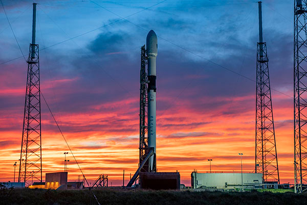
GPS III SV04 rests atop a Falcon 9 rocket, waiting to be sent into orbit. (Photo: SpaceX)
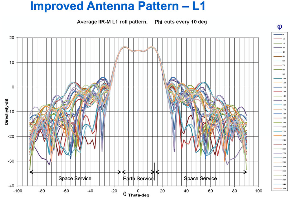
Partnering with the U.S. Coast Guard Navigation Center (NAVCEN), U.S. Space Force and Lockheed Martin Space have released the GPS IIR/IIR-M satellite antenna patterns for worldwide public use.
Additionally, the Institute of Navigation has offered a related ION journal article free to the public to accompany the antenna patterns.
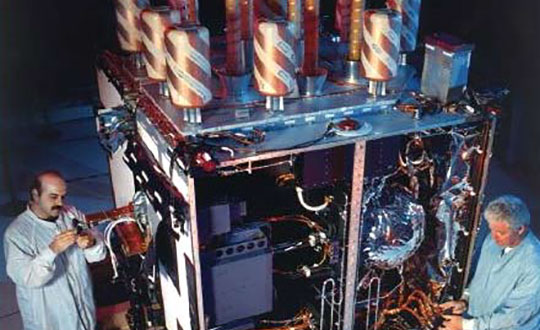
The GPS Block II Replenishment (IIR) space vehicle (SV) began improving upon its baseline design in 2003 with the launch of the first Block IIR SV retrofitted with a redesigned antenna panel. This is the Earth-facing panel providing the GPS L-band broadcast signal. The improved antenna panel includes redesigned L-band elements mounted on the SV Earth-facing structure in the same manner as the original antenna panel.
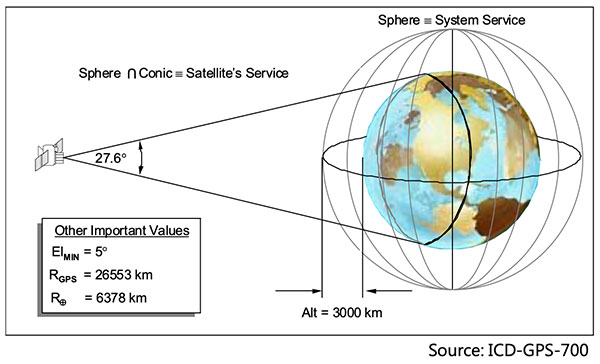
The Earth Terrestrial Service Volume is the near-Earth region up to 3,000 km altitude. (Diagram: NAVCEN/Lockheed Martin)
Spacecraft Navigation
The use of GPS signals for spacecraft navigation has increased in general over the last few decades. Navigation employing GPS observations for spacecraft in low-Earth orbit is now considered routine.
However, the situation is quite different for spacecraft that fly in the Space Service Volume above the GPS constellation, including medium-Earth orbit (MEO), geostationary orbit (GEO) and high-Earth orbit (HEO) satellites, as well as missions to the Moon and beyond.
For these spacecraft, reception of GPS transmit antenna side lobe signals is essential to improve availability and performance of on-board navigation and timing. In this context, the knowledge of the full antenna pattern (main lobe and side lobes) from the transmitting antennas of each of the GPS satellites is essential.
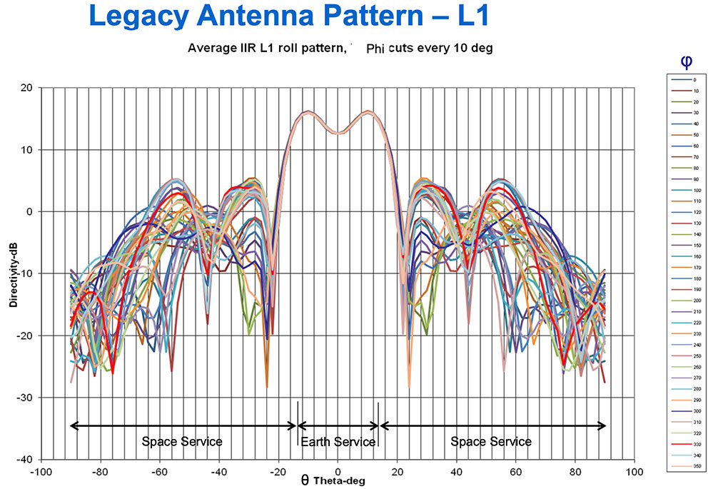
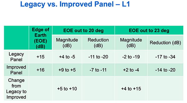
These published antenna patterns and associated ION citation describe both IIR and IIR-M antenna panel versions, their broadcast signal patterns, the performance observed in factory testing, and their on-orbit performance.
Chart: NAVCEN/Lockheed MartinChart: NAVCEN/Lockheed MartinChart: NAVCEN/Lockheed Martin
These patterns represent the current capability of the GPS IIR/IIR-M Space Vehicles. Receiver designers should consult the IS-GPS-200 specifications for use in receiver design and not base design on current signal performance.
GPS technical documents are also available at the NAVCEN website and linked from the GPS.gov website.
Legacy antenna panel on the GPS IIR satellite. (Photo: NAVCEN/Lockheed Martin)
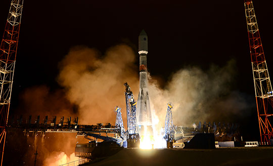
Russia launched a new-generation Glonass-K satellite, number 15, into orbit Oct. 25. Unlike its Glonass-M predecessors, Glonass-K satellites carry two types of navigation signals — frequency-separated and code-separated. The satellites emit additional code-division L2 navigation signals.
In addition to their main functions, Glonass-K satellites will transmit information from the Cospas-Sarsat international search-and-rescue system. Additional Glonass-K satellites are in production at ISS Reshetnev, all with a domestic electronic component base.
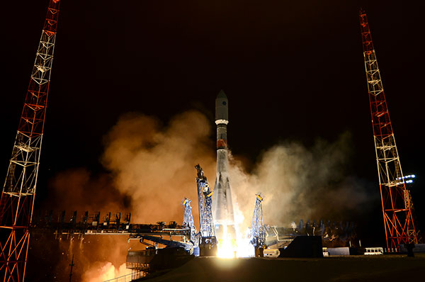
Russia’s Aerospace Forces (VKS) Space Forces launched the satellite aboard a Soyuz-2 rocket from the Plesetsk cosmodrome in the Arkhangelsk region. The launch of the carrier rocket and the maneuvering of the spacecraft into the orbit took place under normal operating conditions, according to Roscosmos.
Two minutes after the launch, the ground-based automated control complex of the Titov Main Testing Space Center acquired the Soyuz-2. On schedule, the Glonass-K satellite was injected into the target orbit by the Fregat upper stage and taken over by the ground-based facilities of the VKS Space Forces.
Photo: Roscosmos
A stable telemetric connection has been established and maintained with spacecraft. The onboard systems of the Glonass-K spacecraft are operating normally.
GLONASS consists of 28 spacecraft, with 24 active, two in reserve, and one Glonass-K undergoing flight tests. Another spacecraft is temporarily out for maintenance.
Glonass-M satellites form the basis of the system’s orbital grouping. Replacing the orbital constellation with Glonass-K spacecraft will ensure the stable operation of the Russian navigation system and increase the accuracy of its navigation determinations up to tens of centimeters.
According to Roscosmos, Glonass-K spacecraft are constructed in an unpressurized design, have a guaranteed period of active existence in orbit increased to 10 years, reduced energy consumption, and significantly lower weight.
Septentrio, a leader in high-precision GNSS positioning solutions, is offering two open-source resources for its GPS/GNSS module receivers.
The first, ROSaic, is a Robot Operating System (ROS) driver for the mosaic-X5 module as well as other Septentrio GNSS receivers.
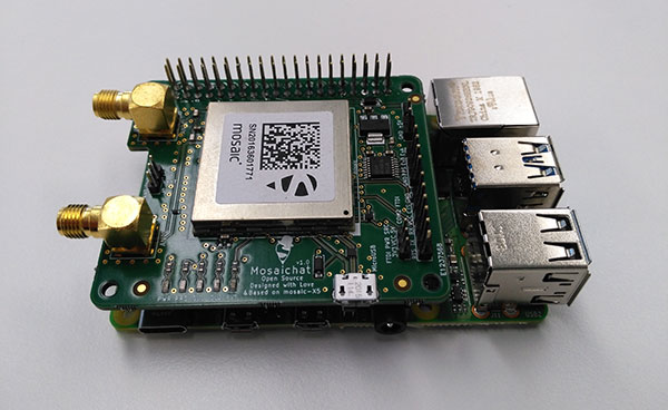
The second project, mosaicHAT, is an open source hardware reference design combining mosaic-X5 with a Raspberry Pi single-board computer.
Both projects facilitate integration of centimeter-level reliable positioning into robotic and other machine automation applications.
Photo: Septentrio
ROSaic driver operates on ROS, a widely used programming environment within the industry as well as academics, commonly used for integrating robot technology and developing advanced robotics and autonomous systems. ROS allows data from numerous sensors to be combined allowing high levels of autonomy.
The mosaicHAT project facilitates accurate and reliable GNSS positioning for robotics and automation on a hardware level. Numerous engineers today use Raspberry Pi for prototyping and initial integrations. The mosaicHAT board is an easy way for integrators to get started with Septentrio’s mosaic-X5 GNSS module.
By plugging mosaicHAT into a compatible Raspberry Pi, users have access to high-accuracy positioning with a high update rate, ideal for machine navigation and control, the company said. The small 56×65 mm board exposes basic interfaces such as USB, serial and general-purpose communication pins. The reference design, footprint and documentation are available for easy board printing or further customization.
“We are excited about both the ROSaic driver and the mosaicHAT being part of the GitHub community and we highly appreciate the initial authors work as well as the future contributors,” said Gustavo Lopez, market access manager at Septentrio. “Both projects are available as open source, thus empowering the community to easily fit autonomous or robotic systems with highly accurate and reliable GNSS positioning technology.”
The aborted launch of the fourth GPS III satellite has sparked an investigation into the SpaceX Falcon 9’s Merlin engine. With only two seconds before launch, SpaceX stopped the scheduled launch of the fourth GPS III satellite on Oct. 2.
Tim Dunn of NASA’s Launch Services Program said at an Oct. 16 briefing that the engines had undergone significant testing since the GPS III launch scrub, including taking the Merlin engines from that rocket back to SpaceX’s McGregor, Texas, test site for further study, reports SpaceNews.com. That investigation has involved NASA and Space Force personnel working with SpaceX.
While the GPS III launch has not been rescheduled, Dunn said that the NASA and SpaceX personnel have learned much, with implications involving the rocket hardware.
GPS III SV04 rests atop a Falcon 9 rocket, waiting to be sent into orbit. (Photo: SpaceX)
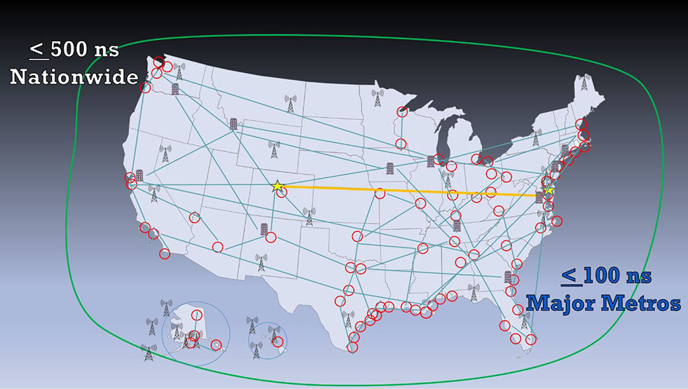
A new white paper sponsored by the Resilient Navigation and Timing Foundation (RNT Foundation) discusses the need and implementation of a reliable and resilient national timing architecture that will include space-based assets. This system-of-systems architecture — GNSS, terrestrial eLoran broadcasts and fiber — is essential to underpin today’s technology and support development of tomorrow’s systems, according to the executive summary of A Resilient National Timing Architecture.
“Everyone in the developed world needs precise time, all the time, whether they know it or not,” said Marc Weiss, one of the paper’s authors and an internationally recognized expert on timing and synchronization. “It is a foundation of every networked technology, digital broadcast, and most navigation systems, to name just a few critical uses.”
Three Paths to Precise Time
“Precise time is so important that everyone needs at least three independent methods of getting it. So, if one, or even two, fail it is not a national disaster,” said Pat Diamond, co-author of the paper. “Our proposed architecture calls for precise time via GNSS, terrestrial eLoran broadcasts and fiber.” Diamond is a long-time network designer, developer, and entrepreneur. He is also a member of the U.S. National Space-Based Positioning, Navigation, and Timing Advisory Board.
Diamond also pointed out that these three methods should be the backbone for timing distribution in the U.S., but won’t be the only methods. “What we are describing is a baseline architecture that will be added to,” he said. “It is a starting point. We envision in the paper additional distribution methods like time from other satellites, user clocks, and so on, all being part of the mix.”
Government Leadership
The U.S. federal government has a leadership interest and responsibility in all of this, according to the paper. Nations have long recognized the military and commercial advantages of determining and distributing precise time. Great Britain’s Longitude Act of 1714 was really about developing a chronometer to support safe navigation of Royal Navy and British merchant fleet. In the United States, the U.S. Naval Observatory has been keeping and distributing a national time scale time since 1845.
“Just because the feds have an important leadership role, doesn’t mean they have to build and own a bunch of systems,” said Dana A. Goward, the paper’s third co-author and executive director of the RNT Foundation. “There are a variety of ways these systems can be established. Public-private-partnerships, subscription contracts like the FAA did with their air traffic ADS-B system, and cooperative agreements are all examples. As we move forward with 5G telecommunications and perhaps even timing and navigation, it will be increasingly important to have a rock solid timing infrastructure to support it all.”
The National Timing Resilience and Security Act of 2018 requires the U.S. Department of Transportation to establish a terrestrial system to backup GPS timing services by December of this year. While the department does not appear to be on track to meet that goal, it completed a technology demonstration program for GPS backup technologies earlier this year. Two companies demonstrated timing distribution by fiber. Another two demonstrated eLoran.
Many Pieces Already in Place
One of the benefits of the proposed architecture is that much of what is called for is already in place, according to the paper. “We already have fiber networks, NAPs (network access points). eLoran is mature and has been deployed by the Brits. And the U.S. government owns enough former Loran-C sites to establish a nationwide eLoran network,” Diamond said. “All we need is a bit of money and some engineering work to put this all together.”
On Oct. 16, Rodrigo da Costa took up his duties as executive director of the European GNSS Agency (GSA), soon to become the EU Space Programme Agency.
He was elected by the GSA Administrative Board on Sept. 15 and met with the ITRE Committee of the European Parliament on Oct. 12.
Da Costa, a Portuguese national who has worked in a number of EU countries, joined the GSA as the Galileo Services Programme manager in March 2017. In this position he was responsible for leading Galileo, the European Union GNSS, in its service provision phase.
He has previously held several senior project management, business development, and institutional account management positions in space industry, in the areas of human space flight, exploration, launchers and research and development.
Da Costa will now be working on transforming the GSA into the EU Space Programme Agency (EUSPA). He will ensure that its existing activities continue to be successfully delivered while also performing new ones required to undertake with the Agency’s new mandate.
Since its creation in 2004, the GSA has made an unparalleled contribution to the EU flagship satellite systems Galileo and EGNOS, which have significantly contributed to the union’s independence and economic growth.
Staffed with highly skilled and dedicated personnel, the agency has boosted innovation, fostered entrepreneurship, led the provision of services, and stimulated the EU economy, in particular through ensuring Galileo and EGNOS uptake across a wide range of market segments thanks to high-quality and secure satellite services.
Rodrigo da Costa, executive director of the European GNSS Agency. (Photo: GSA)
With eyes fixed on the future, EUSPA will further build on the work of the GSA, and will take on additional new responsibilities for further components to the EU Space Programme, including activities in Copernicus (the European Earth observation programme), GOVSATCOM (the EU secure satellite communication system).
Commenting on his new duties da Costa said: “Becoming Executive Director of the Agency means, above all, to lead a team of excellent, dedicated professionals. I’m immensely excited by the opportunity we have to build a successful EUSPA, a key contributor of the EU Space Programme. I’m looking forward to working with all our stakeholders. The task is vast, but I am confident we will be able to play our part, demonstrating to EU citizens what we can do together in EU space activities as GSA/EUSPA.’’
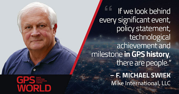
F. Michael Swiek, president, Mike International LLC
It is often said that “Behind every successful man there is a woman.” Likewise, if we look behind every significant event, policy statement, technological achievement and milestone in GPS history, there are people. They make the textbook chronologies of impressive progress both personal and human.
My own 30-year association with GPS has tracked closely with that of GPS World. Here are vignettes that sit most warmly in my “family snapshot album” of great moments in GPS.
In December 1994, the Civil GPS Service Interface Committee (CGSIC) held its first international meeting in Edinburgh, Scotland, hosted by the Northern Lighthouse Board (NLB). The small team of Americans attending the meeting were invited the following day to participate as the “International Team” in the annual NLB quiz competition held in a venerable pub. The competition is hotly contested each year among the NLB divisions, with the winning division commemorated with a brass medallion on a large wooden plaque kept for decades in NLB headquarters. To everyone’s chagrin, the Americans won. The good humor and boisterous camaraderie of that evening laid the foundation for close and candid dialogue between U.S. and European institutions on a wide variety of satellite navigation issues for years to come.
In 1996, Charlie Trimble was to introduce Vice President Al Gore in a ceremony at the White House to announce a Presidential Policy Statement on GPS. On the scheduled day, Charlie was unable to enter the White House, despite being vouched for by White House officials, because he was carrying no photo ID. White House security asked me if I had anything official with Charlie’s picture. They finally accepted a copy of the Trimble Navigation annual report, because in the words of one security officer, “I’ve heard of fake driver’s licenses, but not fake corporate annual reports.” Charlie was admitted.
On September 11, 2001, all of us attending CGSIC and ION in Salt Lake City sat stunned in our conference room watching the news reports from New York. Our meeting sessions were canceled, but we came from our hotel rooms because we needed to be together as friends in our shock and confusion, worrying about our families and friends and what the days ahead would be like. Anyone with a cell phone able to get a line out gladly shared it.
“I’ll only be a minute, just want to check with my family.”
“Talk as long as you want.”
In the mid-1990s in the ION exhibit hall, I was walking and talking with Charlie Trimble, Randy Hoffman (founder of Magellan Systems) and Gary Burrell (co-founder of Garmin), who were engaged in good-natured trash talking about each others’ companies, products and personalities. Glen Gibbons, founder of this esteemed publication, came across us, smiled, and said he was surprised to see such a congenial group of competitors. Charlie responded that in the marketplace they were competitors, but at ION they were all colleagues.
Glen added, “So, all friends!”
All three blurted, “Don’t go that far!” amid more laughs and grins.
The Japan GPS Council became one of the earliest and most influential industry groups in helping to guide the evolution and growth of GPS policy and industry, due to the personal passion of Hiroshi Nishiguchi. When meetings were held in Washington, Nishiguchi, other international representatives, industry and government officials would be guests in our home for convivial dinner chats. Nishiguchi became so comfortable, we considered him like family. He would leave a cardigan sweater in our coat closet between visits, and upon entering our house would remove his tie and suit jacket, go to the closet, and put on his sweater — like Mr. Rogers — before relaxing for the evening. He performed this ritual even when accompanying senior Japanese officials.
So, while technological milestones and policy commitments tell a great deal of the story of GPS, there are also the unique and cherished people, and the privilege it has been to know them as friends.
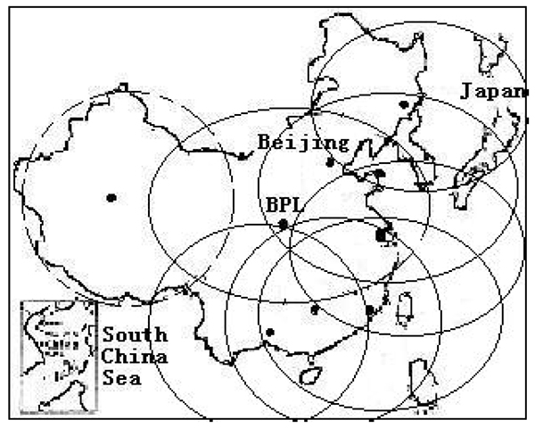
An August 2020 paper published by the journal Sensors revealed China’s plans to expand coverage of its terrestrial Loran positioning, navigation and timing (PNT) system with three new transmitter sites in the western part of the country. The article indicates that this is a part of providing a backup system for GNSS.
According to the paper, “…the vulnerability of GNSS to unintentional and intentional interference signals can be found frequently nowadays. For national security and economic effectiveness, a reliable and complementary navigation system is needed desperately. The suitability of the Loran for a backup navigation system has been evaluated and reported.”
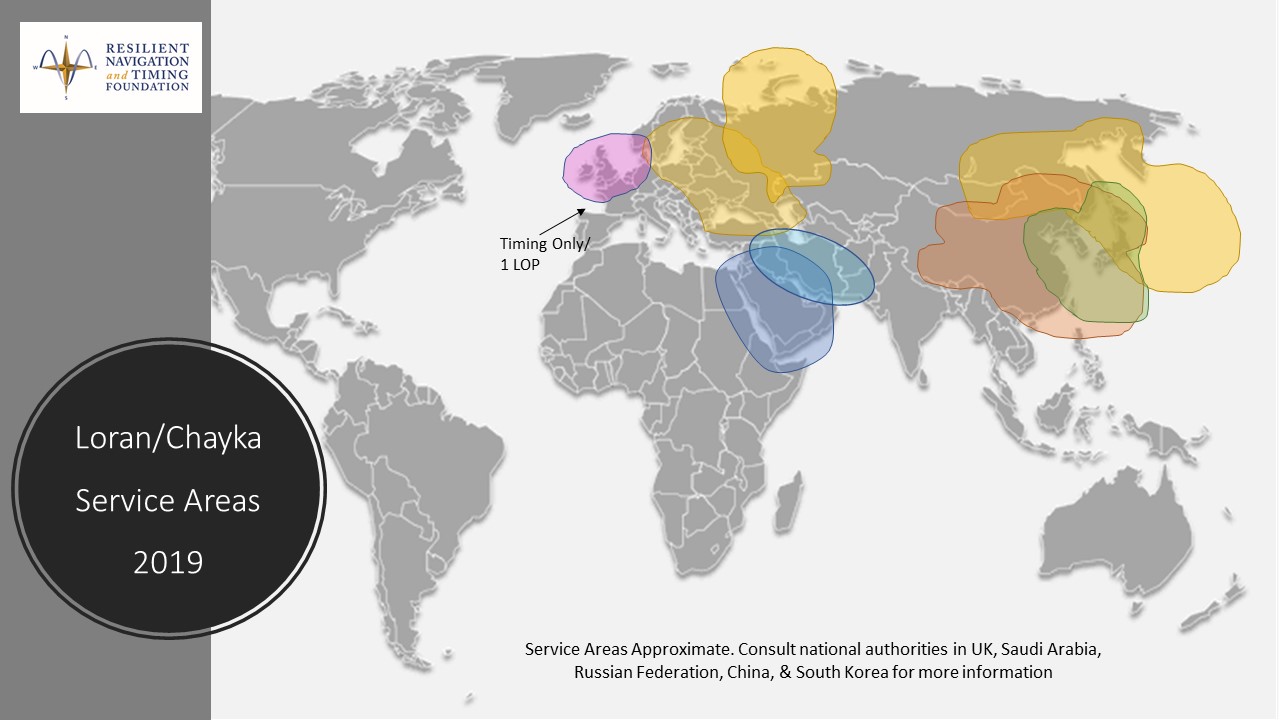
China has operated a Loran system for decades. While the system is capable of operating independently, its signals are also compatible with systems operated by South Korea and Russia. These are coordinated through the Far East Radio Navigation Service (FERNS) to ensure the systems are complementary and reinforce each other where coverage overlaps. The United States and Japan were also members of FERNS until they terminated Loran transmissions in 2010 and 2015, respectively.
Image: RNT Foundation
Little public information about China’s Loran system has been available and our queries have gone unanswered. One of the few documents available in the west is a 2014 paper about Loran-C from the Chinese Academy of Sciences in Shaanxi, China which can be accessed through the RNT Foundation website. It shows substantial Loran coverage in the eastern part of the nation, but only a broken circle indicating “projected coverage” in the west.
Graphic from 2014 Chinese Academy of Sciences paper on Loran showing projected coverage in the western part of the country with a dotted circle. (Image: RNT Foundation)
The single transmitter in that area projected by the 2014 paper could provide a strong, difficult to disrupt timing signal for fixed receivers with known locations.
Three new transmitters will be installed according to the August 2020 paper titled “High-Accuracy Positioning Based on Pseudo-Ranges: Integrated Difference and Performance Analysis of the Loran System.” The increased service in the western part of the country will provide “full coverage” positioning, navigation and timing usable by both fixed and mobile receivers.
The August 2020 paper is the first known documentation in over a decade of specific Chinese intentions regarding its Loran system.
Still, it is not a surprise to many observers. At 2019’s Stanford PNT Symposium, Xiaochun Lu of China’s National Time Service Center described the nation’s plan for a “comprehensive” PNT system. This system will include a wide variety of PNT sources including low earth orbit satellites, inertial systems, local positioning systems, and Loran.
Like Ms Lu, the authors of the August 2020 paper are employed at China’s National Time Service Center, which is part of the Chinese Academy of Sciences.
I spent much of the 1980s working for Magnavox Government & Industrial Electronics Company, which held a number of patents on the GPS system and also developed prototype GPS user sets for the military. I, and others at the company, often gave presentations to industry groups talking about the many commercial and consumer applications for which GPS would be used as the cost and size of GPS receivers declined. By the early 2000s, the applications we had envisioned had been far surpassed.
In the early 1990s, I spent several years at Teletrac, now Teletrac Navman, which was beginning to market a vehicle tracking solution based on its own proprietary time-difference-of-arrival (TDOA) technology, using in-vehicle devices and metro-area-based receiving/transmitting towers. One day, the co-founder and chairman of the company roamed into my office for an update on sales and marketing progress. I changed the subject and, at some risk to my job, said “Dennis, the future of location technology is GPS. It will not just be used to locate vehicles, but even cellular phones. With teams of talented engineers focused on reducing the size and cost of receivers and adapting them to specific applications, ‘the sky is the limit’.” He didn’t fire me, but spent the rest of our discussion telling me why I was wrong — that GPS receivers would always be too large, too expensive, too susceptible to signal blockage, and other limitations.
Thirty years later, the applications I had envisioned for GPS have been greatly surpassed and are constantly expanding. In recent years, my primary focus has been on researching the growth and trends of the commercial telematics market in the U.S. and abroad. Today, in the U.S. alone, some 16 million GPS devices are being used to monitor fleet vehicles and assets, such as trailers and heavy construction equipment. Even in the face of the COVID-19 pandemic, the market remains stable and is on track to grow for the year.
In the future, GPS will play an essential role in the deployment of autonomous vehicles, with help from other technologies needed to optimize location accuracy and reliability. My hat is off to the founding fathers of GPS who include some of the most brilliant technologists of this era.
GNSS has had a major impact on many different industries and market segments, but I believe that the incorporation of GNSS into cell phones has impacted more people around the world than any other. It’s almost hard to remember back in the last millennium when the idea of putting a GPS receiver into a cell phone was first contemplated. Back then, we were just starting the transformation from 1G phones (analog) to 2G phones (digital), and the whole idea of 911 for mobile phones was a huge hurdle facing the entire industry. Three small startups (SiRF, SnapTrack and Global Locate) were all founded with the seemingly impossible dream of putting GPS into every cell phone to provide location information for E911 and other commercial applications. Back in those days, we were trying to convince operators and the FCC that GPS could provide location accuracy better than the 150-meters 67% of the time that the cellular industry was leaning toward with other technologies.
Can you hear me now? A sampling of early cell phones. (Photo: yktr/iStock/Getty Images Plus/Getty Images)
Fortunately for everyone, we were able to convince the industry that GNSS was an answer that should be considered. Today, we see billions of phones around the world with embedded GNSS. Those early phones from Motorola, Nokia, Ericsson and RIM (Blackberry) were truly marvels of engineering development to tightly couple GPS and cellular. Interestingly, none of those phone makers — nor any of those three pioneering companies — exist today, having been subsumed into larger entities due to their success in solving this incredibly complex problem. Those early GPS L1 C/A-only phones have added GLONASS, Galileo, QZSS and BDS, and we are now starting to see support for L5 showing up in smartphones. This has all led to improved availability and accuracy — now not only can we locate E911 calls to the correct civic address for emergency responders, but commercial applications rely on <10-meter accuracy for driving directions, ride sharing and social media applications. Every time I think there is nothing new to do, something always comes along. I’m excited to see what’s next.
Believe it or not, I remember clearly when one of my colleagues, at the beginning of 1990 in my office, made me aware of the upcoming GPS World journal. He went through the list of the already-appointed members of the editorial board and found some key names; Vidal Ashkenazi comes now to my mind. Later on, we received the first issue which, I am sure, must be carefully stored in the library of, at the time my employer, the Institute of Cartography of Catalonia (ICC).
I also remember the day we were processing GPS kinematic measurements of an aerial survey conducted with Sercel NR52 and TR5SB C/A-code L1 GPS receivers (one was 33 x 38 x 33 cm3 and 18 kg; the other was even bulkier, and both operated on valves). That was for the new GPS aerial triangulation method.
Shortly after, the application to airborne laser scanning came, and then INS/GPS integration for airborne remote sensing and mobile mapping. Then came the reinforcing high-speed loop of new applications, technology and challenges. The rest is history. An invariant of these 30 years has been that on our tables there were always one or more issues of GPS World. GPS World issues are always around us, part of our offices’ landscapes.
Last but not least, I cannot tell apart the early days of the journal from its founding editor, Glen Gibbons, who has to be credited for about half the life of the magazine. He brought me onboard GeoConvergencia and, later on, when GeoConvergencia was stopped, to GPS World. I used to share with him ideas and results, and he used to scold me about not publishing them in his journal.