Category: SBAS

  • Testing of Luch-5V Begins Using PRN 140

    The L-band SBAS transponder on the third Luch Multifunctional Space Relay System geostationary satellite, Luch-5V (“v” is the third letter of the Russian alphabet), launched on April 28, has started test transmissions using PRN code 140.

    The satellite is positioned at 95° east longitude and completes the Russian three-satellite SBAS constelltion for the System for Differential Corrections and Monitoring. Stations in the IGS tracking network first noticed the signals on July 15, but it wasn’t clear where they were coming from. This is because the satellite is not yet transmitting its position and PRN 140 has also been used by the first Luch satellite, Luch-5A, although it hasn’t been heard from recently. It was expected that Luch-5V would use PRN 141, also assigned for the Luch satellites by the GPS Systems Directorate.

    By using the pseudorange measurements recorded by the IGS stations and the orbit positions of both the Luch-5A and Luch-5V satellites derived from NORAD 2-line element sets, it was confirmed that the PRN 140 signals were indeed coming from Luch-5V.

    The Luch-5V signals have been noted on a few subsequent days but with a very large clock offset from GPS System Time.

  • Occupy Media Space Now EGNOS and Galileo Mission

    By Peter de Selding

    The message to the recent European Space Solutions conference in Prague was simple enough: EGNOS is here, so let’s use it; Galileo is almost here, so let’s promote it.

    Neither task is straightforward.

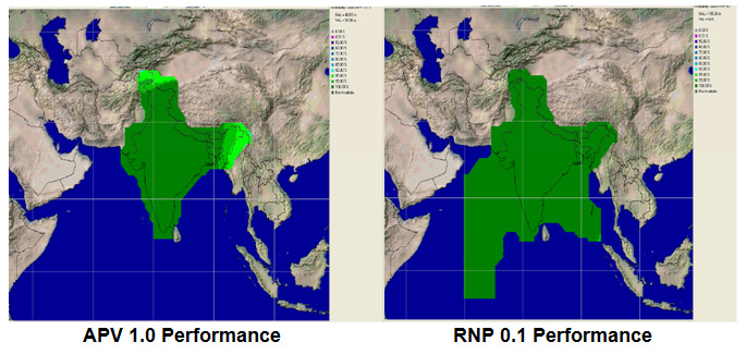
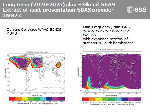
    Take the European Geostationary Navigation Overlay Service (EGNOS), the European piece of a near-global network of terminals on geostationary satellites linked to networks of ground stations to verify GPS signal accuracy, primarily for aviation but with further applications as well. Other pieces of this global network are the Wide Area Augmentation System (WAAS) in the United States, the System for Differential Corrections and Monitoring (SDCM) in Russia,  GPS-aided GEO-augmented Navigation (GAGAN) in India, and Multi-functional Satellite Augmentation System (MSAS) in Japan.

    EGNOS is operational. It works. Once airports publish the required specificafions for localizer performance with vertical guidance (LPVs), aircraft with EGNOS terminals ultimately will be able to use EGNOS for flight terminations up to as low as 200 feet above the runway. Gone is the need for runway infrastructure, and welcome to the long-promised world of satellite-based augmentation systems. “It offers cheap solutions for precision approach,” said Fabio Gamba, chief executive of the European Business Aviation Association.

    In the United States, where business aviation is a bigger market than in Europe, some 3,400 LPVs have been published for 1,670 airports. In Europe, the equivalent figure is 108 LPVs at 77 airports.

    Why the sluggish response? Gamba cited a long list of issues, including some that appeared more political than technical. Part of the reason, some said, was that the EGNOS backers, including the company under contract to manage the system — European Satellite Services Provider (ESSP) of Toulouse, France — have not done enough to get the word out.

    After all, these observers said, EGNOS suffered multiple delays, and its bigger younger brother, Galileo, has had bad press for years as its business model, ownership, regulatory backing, and schedule took turns in making eyes roll in Europe.

    But that’s yesterday’s issue. Thierry Racaud, chief executive of ESSP, said EGNOS posted greater than 99 percent availability in May for its safety-of-life service, which is currently available on none of the other regional GPS augmentation systems except WAAS.

    Racaud promised that the 108 LPVs signed so far would grow to 180 by the end of this year, and that 200-foot level approaches would be certified by late 2015. He said he hoped all 28 member nations of the European Union would have concluded their EGNOS regulatory approvals by 2017 or 2018.

    “What we need now is more users,” Racaud said.

    If EGNOS is not well known on its home turf, imagine its status in Africa, where European companies are trying to sell its adoption. Abdel Nasser Saint’Anna, director of the EGNOS-Africa Joint Program Office, said Africa should be Exhibit A for an EGNOS success pitch. Of the 2,500 runways in Africa, he said, only 177 were equipped with instrument landing systems (ILS), the system EGNOS and Galileo ultimately would like to replace.

    Galileo, with Four, in Fourth

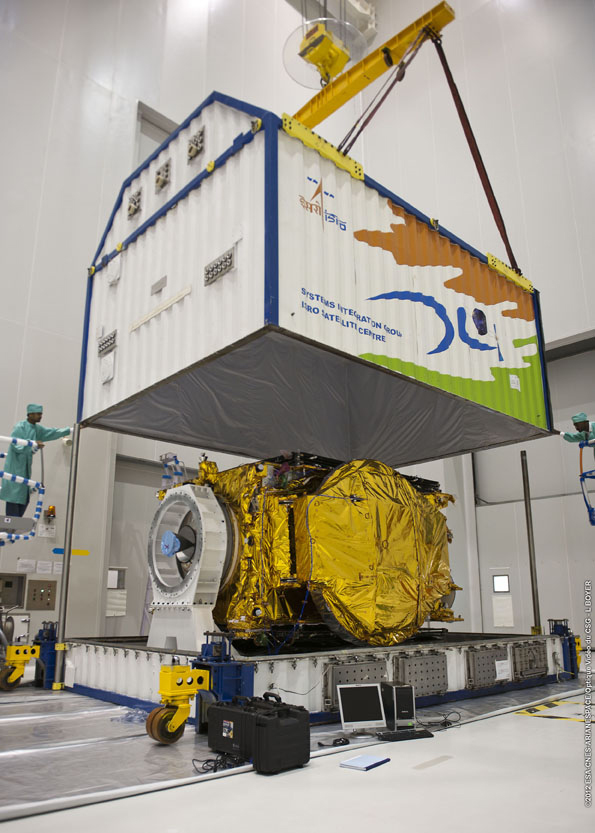
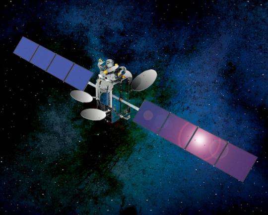
    Galileo, too, appears headed for a successful adoption in many areas around the world even if, once operational, it likely will be the fourth global GNSS system in place, after GPS, Russia’s GLONASS and China’s BeiDou — not counting the large regional Indian and Japanese systems now being developed.

    For those with scorecards, recall that four Galileo satellites, designed to validate the system’s performance, are in orbit. Carlos des Dorides, director of the European GNSS Agency (GSA) in Prague, said tests in May proved Galileo’s interoperability with GPS.

    More importantly, des Dorides said the tests demonstrated how much better it is for consumers when their terminals access GPS and Galileo together. That should be obvious. Less obvious: Results were much better than with terminals tracking both GPS and GLONASS, he said.

    The more satellites, the better? Yes, at least up to a point. Whether terminal manufacturers will see fit to incorporate all four global GNSS constellations, plus one or two of the regionals, in their hardware remains to be seen.

    But the pent-up demand for Galileo does now seem better than it was as little as a year ago, despite the fact that some Asian nations attending the conference said they need Galileo to demonstrate its vitality sooner rather than later. Some officials said signal-quality issues with Beidou, and the recent GLONASS outage, will more than make up for Galileo’s delays as long as deployment progress is visible.

    The fact remains that by 2020 there will be more than 100 GNSS satellites in medium-Earth orbit, in addition to the augmentation terminals on geostationary satellites.

    A graphic presented by SpaceTec Partners’ Rainer Horn, whose company has been charged with preparing the Asian market for Galileo, showed just how dense the Asian skies will be with GNSS assets at the end of the decade. India, China, Japan, Taiwan, and South Korea are SpaceTec’s current Asian targets.

    The message from these markets: Launch Galileo now. Drum up support. Occupy the media space.

    Did the European Commission get the message? Time will tell. The next opportunity to wave the Galileo flag comes in late August, when the first two of 22 full-operational-capability satelllites will be launched from Europe’s spaceport in South America. Two more are scheduled to follow late this year.

    Eight satellites in orbit by Christmas will not make an operational service, whatever the brochures say. But does that matter? Galileo now has secure funding, through 2020, for most — not all — of what it needs to launch a full constellation. Absent a new issue, by 2017 few will remember the delays.

    Paul Weissenberg of the European Commission, who has seen the Galileo wars up close, reminded the European Space Solutions audience in Prague that one future Galileo customer sits outside the commission’s offices, waiting for approval to use Galileo’s PRS encrypted service. The U.S. Defense Department’s desire for Galileo does not have an expiration date. Just launch it.

  • SBAS Working Group Looks to Galileo for Aircraft Guidance, Defines L5

    SBAS Working Group Looks to Galileo for Aircraft Guidance, Defines L5

    Plans to harness Galileo and other satnav systems for next-generation satellite augmentation systems for aviation and other high-performance uses took a significant step forward at the latest gathering of worldwide operators and experts, reports the European Space Agency.

    Satellite augmentation systems combine additional ground stations and satellite transponders to sharpen satnav accuracy and reliability across given geographical regions — based on the U.S. GPS for now, but with plans to move to a multi-constellation design additionally employing Europe’s Galileo, China’s BeiDou, and Russia’s GLONASS systems in the post-2020 era.

    The 26th Satellite Based Augmentation Systems (SBAS) Interoperability Working Group (IWG) took place in New Delhi, India on February 5–7.

    The 26th SBAS Interoperability Working Group (IWG) was introduced by V. Somasundaram, board member of the Airport Authority of India.
    The 26th SBAS Interoperability Working Group (IWG) was introduced by V. Somasundaram, board member of the Airport Authority of India.

    Among its achievements was to converge on a standard message definition for one of the channels — known as L5 — of the planned second-generation SBAS systems, which will utilize dual-frequency, multi-constellation signals.

    “Two solutions had been put forward, one by ESA based on work by European industry and one from the U.S. Federal Aviation Administration and Stanford University,” explains ESA’s Didier Flament, co-chair of the IWG.

    “A single definition coordinated between both bodies has been presented, combining the benefits of both solutions. The formal IWG review and approval loop has now been started with the objective of finalizing it for September’s IWG meeting.

    “The aim is to have it ready to submit to the official international SBAS standardization bodies — the International Civil Aviation Organization and the Radio Technical Commission for Aeronautics — as soon as October.”

    The meeting also marked the significant progress made by Indian’s own SBAS system GAGAN, which underwent its final stability test last summer, followed by its safety certification in December.

    At this point GAGAN was declared certified for non-precision approach users , followed by its safety-of-life service being formally offered to civil aviation users on 14 February.

    GAGAN has been jointly undertaken by the AAI and the Indian Space Research Organisation, intended to provide improved accuracy, availability and integrity necessary to enable users to rely on satnav signals for all phases of flight – from en route as well as approach to all qualified airports within the GAGAN service area.

    SBAS services worldwide

    GPS has an accuracy of 5–10 meters. Across Europe, that accuracy is sharpened to 1–2 meters through EGNOS, an operational precursor to Europe’s Galileo global satnav system.
    EGNOS is an operational precursor to Europe’s Galileo global satnav system.

    GAGAN is the fourth certified SBAS to enter servicer worldwide. Europe has the European Geostationary Navigation Overlay Service (EGNOS), which was designed and built by ESA then turned over for operation by the European Satellite Service Provider, ESSP, overseen by the European Global Navigation Satellite System Agency  (GSA) — both of whom also participated in the meeting. ESA retains responsibility for the future evolution of EGNOS.

    The U.S. has the Wide Area Augmentation System (WAAS), developed and operated by the Federal Aviation Administration, with an extension over Canada called CWAAS (Canadian WAAS). WAAS celebrated its 10th anniversary of operational life last July.

    Japan has the Multi-functional Satellite Augmentation System (MSAS), developed and operated by Japan’s Civil Aviation Bureau. Japan is currently discussing plans to merge this capability with their new home-grown satnav system, QZSS.

    Along with GAGAN, the meeting also covered the progress made by the other SBAS systems under definition or development — the Russian SDCM, Chinese SNAS and Korean K-SBAS.

    The follow-up IWG meeting is due to take place in September in Tampa, Florida.

    Planned GAGAN service coverage for the two different service levels (RNP0.1 and APV1). GAGAN has been jointly undertaken by the Airport Authority of India and the Indian Space Research Organization, ISRO, to achieve smooth transition to satellite-based navigation and seamless air traffic management across continents. GAGAN is designed to provide improved accuracy, availability and integrity necessary to enable users to rely on GPS for all phases of flight, from en route through approach for all qualified airports within the GAGAN service volume. More precisely it is aimed to provide Non Precision Approach RNP0.1 service levels to the entire Indian Flight Information Region and Precision Approach APV1 service (equivalent to the current EGNOS Service) within a specified service volume within Indian land mass.
    Planned GAGAN service coverage for the two different service levels (RNP0.1 and APV1). GAGAN has been jointly undertaken by the Airport Authority of India and the Indian Space Research Organization, ISRO, to achieve smooth transition to satellite-based navigation and seamless air traffic management across continents. GAGAN is designed to provide improved accuracy, availability and integrity necessary to enable users to rely on GPS for all phases of flight, from en route through approach for all qualified airports within the GAGAN service volume. More precisely it is aimed to provide Non Precision Approach RNP0.1 service levels to the entire Indian Flight Information Region and Precision Approach APV1 service (equivalent to the current EGNOS Service) within a specified service volume within Indian land mass.

    Tackling ionospheric interference

    The New Delhi IWG took place concurrently with a related meeting, the ICAO’s 4th Ionospheric Study Task Force. This group has been tasked with the objective of developing region-specific models of ionospheric models to compensate for satnav signal interference or loss.

    The ionosphere, the electrically sensitive outer shell of Earth’s atmosphere, can be perturbed by solar activity. And because satnav signals pass from space by Earth they can then be disrupted in turn. Equatorial regions see the greatest disturbance, including signal delay or ‘scintillations’ making signals unstable.

    The aim is to develop reliable ionospheric models to compensate for these effects, particularly for equatorial SBAS regions, such as India. ESA is contributing with data from its worldwide Monitor network, gathering data to improve future EGNOS performance and potentially support further geographical extension.

    Comparing current worldwide SBAS coverage – based on WAAS, EGNOS and MSAS – to the situation envisaged for 2020–25: near-global coverage based on WAAS, EGNOS, MAAS, SDCM and GAGAN, with an expanded network of stations in the southern hemisphere, based on a common dual-frequency/dual satnav standard being finalized by the SBAS IWG.
    Comparing current worldwide SBAS coverage — based on WAAS, EGNOS and MSAS — to the situation envisaged for 2020–25: near-global coverage based on WAAS, EGNOS, MAAS, SDCM and GAGAN, with an expanded network of stations in the southern hemisphere, based on a common dual-frequency/dual satnav standard being finalized by the SBAS IWG.
  • NovAtel Awarded Contract to Supply WAAS Receivers for FAA System

    NovAtel's WAAS G-III receiver.
    NovAtel’s WAAS G-III receiver.

    NovAtel, an OEM provider of high-precision GNSS positioning products, has been contracted by the Federal Aviation Administration (FAA) to produce and deliver 176 Wide Area Augmentation System (WAAS) third-generation reference receivers (G-III).

    The contract includes engineering support for the receiver as well as support for the current generation reference receiver (G-II), Geostationary Earth Orbit Uplink Subsystem – Type 1 (GUST) receiver, and Signal Generator (SIGGEN).

    The third-generation WAAS program is a technology refresh of the highly successful, currently operating second generation WAAS Satellite-Based Augmentation System (SBAS).  WAAS provides integrity monitoring, correction data, and increased satellite availability to users of GPS within its coverage area.  The integrity monitoring features of the WAAS allow the use of GPS L1 C/A for safety-of-life applications and in particular for the civil aviation industry.   The third-generation WAAS will monitor and augment the modernized GPS L5 signal, allowing aviation receivers to operate in two protected aviation frequency bands with assured integrity.

    NovAtel's WAAS G-II receiver.
    NovAtel’s WAAS G-II receiver.

    NovAtel’s reference receivers and uplink station equipment have been a central element of the WAAS since its inception. The G-III reference receiver uses fully updated hardware and tracks all GPS signals including the legacy GPS L1 C/A, L2P(Y) (semi-codeless), and the modernized L2C, L5, L1C signals as well as the WAAS L1 C/A  and L5 signals.

    The WAAS G-III reference receiver provides a rich set of range measurement data, signal integrity metrics, and logs for processing by the system’s data communication processor. The receiver architecture is designed to facilitate future expansion and reconfiguration to support the evolving needs of WAAS and other SBAS systems worldwide, including multi-constellation augmentation systems.

    “We have a long relationship with the FAA and have worked very closely with the WAAS program team to develop a third-generation ground reference receiver that carries over the pedigree of our first and second generation products, while adding features and processing capacity required for the modernized system,” said Jason Hamilton, director of marketing for NovAtel. “The WAAS G-III was designed and tested specifically for ground reference networks requiring reliable continuous operation, high-longevity components, and DO-178B design assurance.”

  • Accord’s NexNav GPS Receiver Supports Freeflight with FAA’s Capstone Retrofit Project

    Accord Technology’s NexNav GPS receiver will be supporting FreeFlight Systems with its recently awarded FAA Capstone Retrofit Project. In March 2013, FreeFlight and Accord announced their collaboration to develop practical and cost-effective ARINC 429 WAAS GPS solutions that enable aircraft operators to meet ADS-B, RNP (0.3) and other performance-based navigation mandates, worldwide.

    The NexNav Circuit Card Assembly (CCA) will integrate with FreeFlight’s upgraded automatic dependent surveillance-broadcast (ADS-B) avionics to fulfill the requirements of the second phase of the FAA Capstone Project.

    “This is an excellent example of how we are working closely with FreeFlight Systems to create state-of-the-art NextGen solutions that are not only meeting upcoming mandate requirements but doing it in a cost effective manner,” stated Hal Adams, Chief Operating Officer for Accord Technology, LLC.

    The Accord Technology NexNav product line revolves around two key receivers, NexNav mini and NexNav MAX. The receivers are at the heart of embedded customer solutions whether as a Circuit Card Assembly (CCA) or embedded in the Line Replacement Unit (LRU) as a stand-alone GPS solution.

    NexNav mini was the industry’s first GPS receiver and sensor qualified to fully support the known worldwide and U.S. FAA ADS-B GPS source requirements The NexNav mini and MAX are compatible with EGNOS and other Satellite Based Augmentation Systems (SBAS) to the extent they are is compatible with WAAS.

  • Luch-5B Starts SBAS Test Transmissions

    News courtesy of CANSPACE Listserv.

    According to tracking data from stations of the International GNSS Service’s Multi-GNSS Experiment, the second Russian Luch satellite, Luch-5B, started transmitting GLONASS and GPS differential corrections on January 17, 2013, at around 11:07 UTC.

    Luch-5B, launched on November 2, 2012, carries a transponder for the System for Differential Correction and Monitoring satellite-based augmentation system. The satellite, occupying an orbital slot at 16 degrees west, uses PRN code 125. Transmission tests are not continuous.

  • Luch-5B Arrives at Orbital Slot

    The second Russian SBAS satellite, Luch-5B, has now been positioned at its designated orbital slot of 16 degrees west longitude. The satellite had been in a drift orbit since its launch on November 2 at 21:04:00 UTC along with the domestic communications satellite Yamal-300K.

    Tracking data from NORAD/JSpOC showed Luch-5B arriving at its geostationary position by about December 13. The footprint of the satellite is shown below with the elevation-angle contours at 30-degree intervals.

    Luch-5B is expected to use PRN code 125.

  • Update on EGNOS and GAGAN SBAS Satellites

    Source: GPS
    The shipping container that protected GSAT-10 during its travels from India to French Guiana is removed inside the Spaceport’s S5 payload preparation facility, revealing the spacecraft.


    News courtesy of CANSPACE Listserv.

    UPDATE: According to an Arianespace press release issued Thursday, the launch of the GSAT-10 and Astra 2F satellites is now scheduled for September 21.
    SES-5. The SES-5 geostationary communications satellite (also known as Sirius 5 and Astra 4B), which was launched on July 9, 2012, arrived at its orbital slot of 5 degrees east longitude on or about July 19. The current position is actually about 5.2 degrees.

    The satellite carries L1 and L5 transponders for the European Geostationary Navigation Overlay Service (EGNOS) satellite-based augmentation system. According to a spokesperson from the Space and Missile Systems Center, the Global Positioning Systems Directorate has assigned C/A PRN code 136 and L5 PRN code 136 for use by the satellite.

    GSAT-10. The Indian Space Research Organisation’s GSAT-10 geostationary communications satellite has arrived at the European spaceport in Kourou, French Guiana. The satellite carries a transponder for the GPS and GEO Augmented Navigation (GAGAN) satellite-based augmentation system.

    GSAT-10 will be launched together with the Astro 2F satellite by an Ariane 5 rocket on September 21. GSAT-10 is expected to be positioned at 83 degrees east longitude and use PRN code 128. It will join the first GAGAN-equipped satellite, GSAT-8, which is at 55 degrees east longitude and is transmitting test signals on the L1 frequency using C/A PRN code 127.

    Although GSAT-8 reportedly carries a dual-frequency transponder, no L5 signals from this satellite have yet been detected by International GNSS Service tracking stations.

  • Second Russian SBAS Satellite Prepared for Launch

    News courtesy of CANSPACE Listserv.


    Luch-5B, the second of a set of three geostationary satellites being launched to reactivate Roscosmos’s Luch Multifunctional Space Relay System, has been delivered to the Baikonur Cosmodrome. It arrived together with the Yamal-300K satellite in a single shipping container aboard an Antanov An-124-100 Ruslan flight from Krasnoyarsk.

    This marked the first time that Information Satellite Systems – Reshetnev has used the special container, which is large enough to carry two middle-class spacecraft at one time. According to the company, sophisticated equipment fitted with a control system that helps monitor the environment inside the container helps avoid any chances of external damage or unwanted environmental impact during transportation.

    Luch-5B is now undergoing preparations for launch.

    The Luch system will be used to relay communications and telemetry between low-Earth-orbiting spacecraft, such as the the Russian segment of International Space Station, and Russian ground facilities.

    The system’s satellites also carry transponders for the System for Differential Correction and Monitoring (SDCM), Russia’s satellite-based augmentation system. The transponders will broadcast GNSS corrections on the standard GPS L1 frequency using C/A PRN codes assigned by DoD’s Global Positioning Systems Directorate.

    As previously reported, Luch-5A, which was launched on 11 December 2011, has been placed in an orbital slot at 95 degrees east longitude. It began transmitting corrections on July 12, 2012, using PRN code 140.

    Luch-5B, scheduled for launch on September 7, 2012, will be positioned at 16 degrees west longitude.


    Satellite Luch-5B in an anechoic chamber at ISS-Reshetnev.

  • Second Russian SBAS Satellite Prepared for Launch

    News courtesy of CANSPACE Listserv.

    Luch-5B, the second of a set of three geostationary satellites being launched to reactivate Roscosmos’s Luch Multifunctional Space Relay System, has been delivered to the Baikonur Cosmodrome. It arrived together with the Yamal-300K satellite in a single shipping container aboard an Antanov An-124-100 Ruslan flight from Krasnoyarsk.

    This marked the first time that Information Satellite Systems – Reshetnev has used the special container, which is large enough to carry two middle-class spacecraft at one time. According to the company, sophisticated equipment fitted with a control system that helps monitor the environment inside the container helps avoid any chances of external damage or unwanted environmental impact during transportation.

    Luch-5B is now undergoing preparations for launch.

    The Luch system will be used to relay communications and telemetry between low-Earth-orbiting spacecraft, such as the the Russian segment of International Space Station, and Russian ground facilities.

    The system’s satellites also carry transponders for the System for Differential Correction and Monitoring (SDCM), Russia’s satellite-based augmentation system. The transponders will broadcast GNSS corrections on the standard GPS L1 frequency using C/A PRN codes assigned by DoD’s Global Positioning Systems Directorate.

    As previously reported, Luch-5A, which was launched on 11 December 2011, has been placed in an orbital slot at 95 degrees east longitude. It began transmitting corrections on July 12, 2012, using PRN code 140.

    Luch-5B, scheduled for launch on September 7, 2012, will be positioned at 16 degrees west longitude.


    Satellite Luch-5B in an anechoic chamber at ISS-Reshetnev.

  • Russian SBAS Satellite Begins Transmissions

    News courtesy of CANSPACE Listserv.


    Luch-5A, the Russian geostationary communications satellite that carries a System for Differential Correction and Monitoring (SDCM) transponder, has started transmitting GPS corrections according to Javad Ashjaee, CEO of Javad GNSS. He has reported that L1 signals using PRN code 140 have been received by Javad receivers today and used to compute code-differential positions. Only GPS corrections are being received currently, no GLONASS corrections.

    As previously reported through CANSPACE, Luch-5A was recently repositioned to 95 degrees east longitude in an apparent switch of positions with Luch-5B, scheduled for launch later this year. Now, it appears, Luch-5A is using the PRN code previously assigned by the Global Positioning Systems Directorate to Luch-5B.

  • SES-5 SBAS Satellite Successfully Launched

    SES-5 SBAS Satellite Successfully Launched

    Artist's rendering of the SES-5. Photo: CANSPACE Listserv
    Artist’s rendering of the SES-5. Photo: CANSPACE Listserv

    News courtesy of CANSPACE Listserv.

    The SES-5 geostationary communications satellite (also known as Sirius 5 and Astra 4B) was launched from the Baikonur Cosmodrome on July 9 at precisely 18:38:29.994 UTC. After a number of manoeuvres by the various rocket stages, the satellite was released from the Breeze-M upper stage into its geostationary transfer orbit (GTO) at 03:50:15.150 UTC on July 10.

    The planned GTO has a perigee height of 4,170 km, an apogee height of 35,786 km, and an orbital inclination of 23.1 degrees. The satellite’s apogee-kick motor should place the satellite into its geostationary Earth orbit (GEO) within the next few days. The GEO sub-satellite point will be at 5 degrees east longitude.

    SES-5 hosts a dual-frequency transponder for the European Geostationary Navigation Overlay Service (EGNOS). The pseudorandom noise codes to be used by the satellite are not yet known.

    “SES-5 is an important addition to our fleet serving both our commercial and government customer with our first L-band payload for EGNOS to augment the GPS system for Europe. This is a great accomplishment by all of the teams who worked on the SES-5 mission — SES, ILS, Khrunichev, and Space Systems/Loral — and we thank them for their dedicated work on the successful launch,” said SES President and CEO, Romain Bausch.