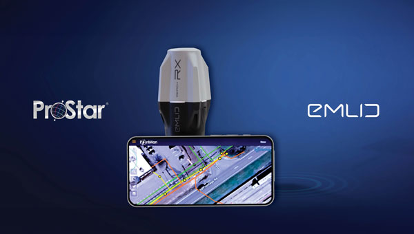
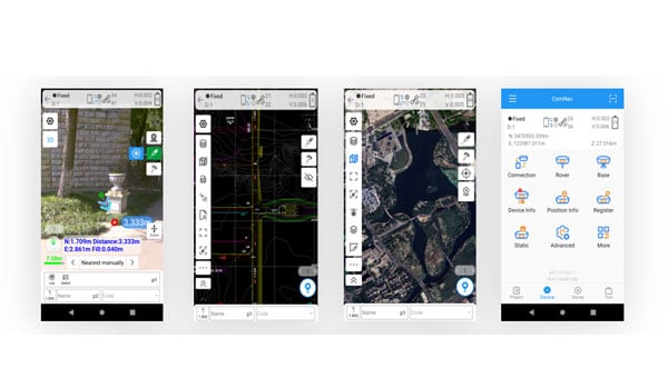
ProStar Holdings, developer of the PointMan Precision Mapping Solutions, and Emlid Tech, European maker of high-precision GNSS equipment, are partnering to bring centimeter-level precision and cost-efficiency to mapping of underground utilities and other critical infrastructure.
The strategic partnership offers ProStar’s PointMan platform, powered by Point One RTK correction services with Emlid’s lightweight and survey-grade GNSS receivers. By combining PointMan’s cloud and mobile precision-mapping solution with Emlid Reach receivers, Emlid’s end-users anywhere in the world have access to an affordable, centimeter-accurate mapping solution.
Emlid offers a range of cost-efficient and lightweight utility mapping equipment. The Emlid Reach RX is a pocket-sized high precision RTK GNSS receiver providing fast setup with no configuration required. For precision mapping trenches in challenging conditions, the Reach RS3 can be used as a base or a rover and provides centimeter-level geopositioning with tilt compensation.
PointMan with Point One RTK corrections provides an easy-to-use mobile mapping solution that uses more than 2,000 base stations communicating with all four major satellite constellations.
“We’re thrilled about this partnership,” said Dmitriy Ershov, Director of Business Development at Emlid. “PointMan mobile mapping software is well-recognized for its versatility and ease of use, and it is exciting to see PointMan continue to evolve, especially with the inclusion of Point One RTK. We are delivering survey-grade accuracy to professionals worldwide in a simple, all-in-one solution.”
Page Tucker, CEO and founder of ProStar, added, “We are strategically aligning with several leading equipment manufacturers to establish a global distribution network. Emlid’s GNSS receivers, combined with PointMan powered by Point One, create a comprehensive and affordable precision mapping solution with unmatched accuracy, coverage, and performance that empowers Emlid’s customers worldwide.”
Read a roundup of recent products in the GNSS and inertial positioning industry from the April 2025 issue of GPS World magazine.
OEM
INS With three additional GNSS receiver variants
Photo: Topcon
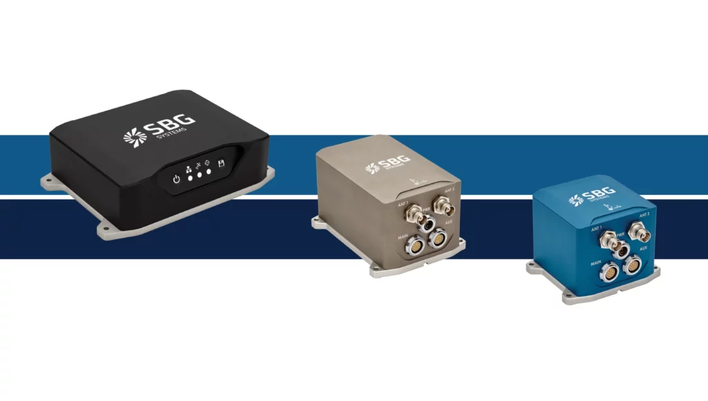
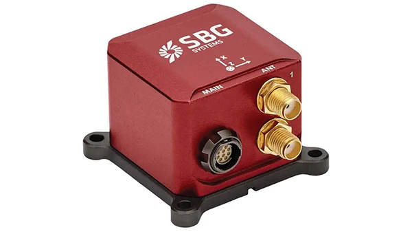
SBG Systems has upgraded its inertial navigation systems — Ekinox, Apogee and Navsight — with new GNSS receiver options. The latest update introduces three additional GNSS receiver variants.
These include:
Marinestar, which supports Fugro Marinestar, delivering precise point positioning (PPP) with centimeter-level accuracy via L-band corrections without requiring a base station. It is optimized for marine applications.
HAS Ready / NavIC, which includes Galileo E6 support for the upcoming Galileo High Accuracy Service (HAS), offering free decimeter-level PPP corrections globally. Additionally, it supports the Indian NavIC system.
Centimeter-Level Augmentation Service, which is tailored for users in Japan; this variant utilizes QZSS L6 signals to provide free PPP corrections without external services.
All GNSS variants integrate seamlessly with SBG Systems’ antenna portfolio and Qinertia post-processing software. Users select the appropriate GNSS variant at purchase to match their operational requirements. These enhancements aim to provide versatile solutions across diverse industries while ensuring reliable performance.
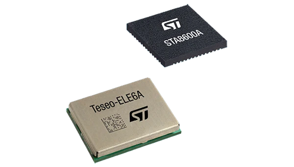
The GNSS receivers in the Teseo VI family use multi-constellation and quad-band signal processing on a single chip, achieving centimeter-level accuracy for various applications. The Teseo VI family includes the STA8600A and STA8610A models. These receivers are designed for automotive applications such as advanced driver assistance systems and autonomous driving, as well as industrial uses, including asset tracking, mobile robots and precision agriculture.
The Teseo VI+ variant can host enhanced positioning engines developed by third-party companies, providing real-time kinematics for centimeter position accuracy.
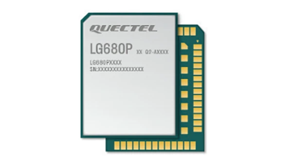
The LG680P is a multi-constellation, quad-band GNSS module designed for high-precision positioning and to enhance signal quality and precision through concurrent reception of L1, L2 and L5 frequency bands. It supports Galileo E6, QZSS L6 and BDS B2b signals for precise point positioning, ensuring horizontal accuracy of up to 0.8 cm + 1 ppm without requiring local or broadband connectivity.
To ensure signal integrity in environments with electromagnetic interference, the module features professional-grade anti-jamming technology, including built-in NIC algorithms that suppress narrow-band interference. It supports external active antennas for enhanced signal reception and positioning accuracy. It is ideal for applications such as autonomous lawnmowers, delivery robots, surveying equipment and precision agriculture. Quectel complements it with two external GNSS antennas: the YEGR001W8AH geodetic antenna and the YEGD006U1A compact patch antenna.
The New Ellipse firmware upgrade for the Ellipse product line allows the system to now be used as an attitude and heading reference system or inertial navigation system. It is designed to enhance navigation, attitude and heave performance for stable and accurate positioning, even in challenging conditions.
It introduces advanced GNSS-denied capabilities, featuring newly integrated flags that trigger when GNSS jamming or spoofing threats are detected. This allows users to reject or re-enable external sensors — such as GNSS — without resetting the filter. The user-friendly interface allows for fast and flexible configuration using simple command lines, enabling users to tailor the Ellipse to their specific needs and applications.
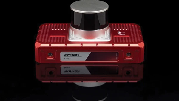
Localization Solution Operates in GNSS-denied environments
Photo: OxTS
WayFinder is a localization solution designed for GNSS-denied environments. It integrates a GNSS/INS system, onboard processor, lidar scanner and two cameras, enabling precise navigation in areas with limited satellite coverage. The system features Lidar Boost, a software technology that enhances GNSS/INS performance by processing lidar data to compensate for missing or inaccurate GNSS updates in real time. This ensures high-accuracy localization and seamless transitions between GNSS-supported and GNSS-denied environments.
WayFinder enables precise navigation for autonomous vehicles in ports, mining and indoor automotive testing without fixed infrastructure. It also provides reliable positioning for surveyors in areas with limited GNSS coverage.
Virtual Surveyor Version 10 introduces Basic Topographic Design tools, allowing users to document terrain changes such as graded roads, water ponds and building surfaces. The software now features four subscription plans — Valley, Ridge, Mountain and Peak.
Ridge plan: Focuses on surveying a single moment in time using one drone data set.
Mountain plan: Adds Timelines to compare surveys across different times, visualizing changes through Time Steps.
Peak plan: Includes advanced Topographic Design tools for planning future structures by creating new Time Steps. These tools allow users to design features such as roads or ponds directly on UAV-derived models, with automated alignment and volume calculations for cut-and-fill operations.
Version 10 introduces drawing guides, available in the Ridge plan and above, enabling precise drawing of points at specific intervals or angles. Walk Mode, included in all plans, allows users to explore 3D terrain at ground level for better visualization. Timelines, featured in the Mountain and Peak plans, facilitate the comparison of multiple surveys conducted at different times and the integration of future designs. These improvements seek to streamline processes for engineering surveyors, supporting applications in construction, mining and water management.
The Jupiter Laser RTK integrates GNSS, auto-IMU, laser and dual camera systems into a single unit. It incorporates a precise green laser that remains visible even in bright daylight. This feature allows for precise measurements of points in hard-to-reach, signal-blocked or potentially hazardous locations. It also features a night vision camera, allowing users to see feature points even in low-light conditions. The RTK system’s laser range is up to 50 m, making it suitable for challenging surveying environments. It incorporates visual technology to offer surveyors an immersive experience during surveying and stakeout operations, improving working efficiency and productivity.
Version 2.1.0 of AgEagle Aerial Systems’ eBee VISION application software introduces circular and grid mapping features, allowing users to generate 2D or 3D maps using external post-processing software for more comprehensive geospatial data.
The eBee VISION 2.1.0 can continue missions in GNSS-denied environments and allows manual deactivation of GNSS to prevent jamming or spoofing. It implements the STANAG 4609 standard, the official format for motion imagery exchange within the NATO nations. This involves embedding UAV position and camera information into the videos recorded by the UAV and those broadcasted by the Ground Control Station. Its inclusion in the system seeks to enhance interoperability with third-party applications, which is key for military-grade UAVs.
It offers enhanced control over the Silent Tactical Landing feature. Users can now manually adjust the landing position on the map, with the system providing range estimates to inform operators of the UAV’s reach. This functionality offers greater flexibility in mission planning and execution, particularly in tactical scenarios requiring precise landing control. The system is ideal for defense, public safety and utilities applications.
‘Drone-in-a-Box’ Solution Designed for vehicle-mounted deployments
Photo: DJI
The DJI Dock 3 “drone-in-a-box” solution is designed for vehicle-mounted deployments and 24/7 remote operations in various environments. This system is compatible with the Matrice 4D and Matrice 4TD UAVs, which feature advanced cameras and IP-rated protection for challenging conditions. The UAVs are ideal for public safety, emergency response and infrastructure inspection.
This system supports flexible deployment options, including vehicle-mounted setups optimized for emergency operations and long-distance inspections. It enables horizontal calibration and cloud-based dock location adjustments. Two docks can be mounted on a single vehicle to facilitate dual-UAV rotations for enhanced efficiency. In fixed deployments, the D-RTK 3 Relay Fixed Deployment Version can be added to improve video transmission and satellite connectivity.
The Matrice 4D and 4TD UAVs have a wide-angle camera, medium tele camera, tele camera and laser range finder. The Matrice 4D features an advanced camera suite designed for high-precision mapping. The Matrice 4TD includes an infrared thermal camera for public safety and emergency response applications. The system includes a Flight Termination System to support regulatory compliance in strictly controlled airspace. This system can manually or automatically stop drone operations if necessary.
Casia G Release 4.0 is a software update that enables nighttime detection of aircraft, allowing 24/7 beyond visual line of sight (BVLOS) UAS operations. The update supports BVLOS flights up to 400 ft at night without requiring hardware modifications, offering detection of both cooperative and non-cooperative aircraft. The system detects aircraft at distances of up to 16.7 km with 360° coverage, ensuring safe nighttime operations. When multiple units are used, triangulation technology provides accurate range, altitude and satellite data for intruding aircraft. The update leverages existing hardware to detect navigation and anti-collision lights at night.
The MAS10 is a 77 GHz FMCW marine radar system designed to enhance navigation safety in congested environments under all weather conditions. The ultra-high-definition W-band radar provides centimeter-level resolution, enabling vessels to detect and identify small hazards in heavily trafficked waterways.
Unlike optical and infrared sensors, W-band radar technology penetrates fog, heavy rain and snow, ensuring reliable detection. It operates effectively in low-visibility scenarios, including complete darkness, intense sunlight and shadowed areas where cameras and lidar may struggle.
The Eagle Series line of spatial 3D scanners feature lidar and imaging sensors and are designed for various applications, including reverse engineering, digital twinning, asset management, extended reality, precision mapping and 3D printing.
The series offers scanning capabilities with a range of up to 140 m and precision within 2 cm at 10 m. The lightweight scanner is designed for portability, with a built-in battery providing up to one hour of continuous use.
The scanners are available in Standard and Max versions. The Max model features four 48 MP cameras, enhancing scanning efficiency and producing vivid 8 K panoramic photos. With a point cloud frequency of 200,000 points per second, the Eagle Series is designed for applications requiring highly detailed spatial data.
Upgraded Mapping Package With Google Maps downloads
Photo: Golden Software
Golden Software has upgraded its Surfer mapping and 3D visualization software. Users can now directly download georeferenced aerial and satellite imagery from Google Maps into projects. The latest version also improves 3D visualization tools, focusing on faster and more intuitive creation of visual models. Users can now colorize 3D drill hole intervals based on text keywords, making it easier to interpret subsurface data. Additionally, contour slices can now be added to the 3D view, offering a clearer representation of data layers.
Golden Software has released a beta version (30.0.135) that introduces multiple light sources for improved 3D viewing and customizable legends for better map presentation. These updates are designed to streamline workflows for professionals in industries such as environmental consulting, resource exploration and geospatial analysis, simplifying the creation of professional-grade maps and models efficiently.
NV5 is celebrating two decades of delivering critical geospatial services to the National Oceanic and Atmospheric Administration (NOAA).
For the past 20 years, NV5 has completed more than 220 contracts across 30 states, covering more than 50,000 square miles. These projects involve topobathymetric surface modeling of shorelines, bays, estuaries, lakes, wetlands, rivers and streams to provide detailed data for various applications. The information generated helps NOAA protect and restore natural resources and habitats, update nautical charts and understand the effects of environmental and human-induced changes over time.
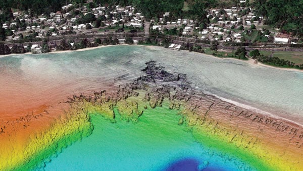
A screenshot from the NOAA ENC Viewer of the updated nautical chart of southern Lake Michigan, created using multibeam bathymetry and backscatter data. (Photo: NOAA)
The company employs airborne remote sensing technologies, such as topobathymetric laser scanning, to capture near real-time changes in nearshore topography and bathymetry. Additionally, NV5 integrates marine vessel-based technologies, such as multibeam echo sounding, to map offshore bathymetry, including sand resources, essential fish habitats and historic shipwrecks.
“Our collaborations with NOAA over the past 20 years have yielded many important insights and baseline data that helps the agency with its core mission of climate monitoring, coastal restoration and supporting marine commerce – all of which supports our nation’s economic vitality and affects more than one-third of America’s gross domestic product,” Dave Bernstein, vice president of hydrospatial operations at NV5, said.
The National Geodetic Survey Remote Sensing Division’s Coastal Mapping Program requires the collection of airborne topographic/bathymetric lidar and digital camera imagery data to enable accurate and consistent measurement of the national shoreline following Hurricane Sandy’s landfall. (Photo: NV5)
In one notable project, NV5 conducted a large-scale hydrographic survey in southern Lake Michigan for NOAA’s Office of Coast Survey. The survey covered 481 square nautical miles from northeast Chicago to Michigan City, Indiana — an area that had not been surveyed since the late 1940s. Using multibeam bathymetry and backscatter data, NV5 updated NOAA nautical charting products to improve maritime safety along the Michigan, Indiana and Illinois shorelines. Under NOAA’s Office for Coastal Management contract, NV5 also provided certified hydrographer expertise aboard the Pisces (R226), a NOAA fisheries research vessel. These efforts included overseeing the collection and processing of hydrographic data for marine habitat mapping.
A view looking south at the Submarine Canyon on Asan Point, Guam. The image was created from the lidar bare earth model and lidar point cloud colored by elevation and RGB values from imagery respectively. (Photo: Partnership between NV5 and Woolpert)
NV5 has also contributed to NOAA’s Coastal Change Analysis Program through projects that utilized aerial multispectral imagery and machine learning techniques. In Rhode Island, NV5 partnered with the National Estuarine Research Reserve System to study salt marsh habitats and produce change mapping products.
A view looking northeast from Virginia Key shows the topobathymetric surface of the intertidal zone near Fisher Island, Florida. (Photo: Nicholas Klein / iStock / Getty Images Plus / Getty Images)
Similarly, high-resolution land cover products were created for Brown County, Wisconsin, and key watersheds to assess urban growth, map wetlands, delineate wildlife habitats and monitor land cover changes over time. Other initiatives include mapping eelgrass habitats along coastal Massachusetts using multispectral aerial imagery and analyzing satellite imagery for wetland changes in the Great Lakes region.
Through these diverse projects, NV5 continues to provide NOAA with essential geospatial data that supports its mission of environmental stewardship and maritime safety while contributing to national economic vitality.
Atlas, a European cloud-based GIS platform, has introduced several new features aimed at simplifying geospatial workflows for teams without requiring coding expertise. The centerpiece of this launch is the Workflows engine, which allows users to visually design and automate spatial analysis processes — such as filtering data, performing calculations and updating layers — without writing code. By streamlining these tasks into automated chains, the feature seeks to reduce the time and effort traditionally spent on repetitive scripting.
Relations, a feature designed to connect datasets for smarter app development, enables users to link related data points, such as inspections or measurements, directly within the platform. Atlas also released Forms, a tool for structured field data collection, and Mobile Views, which allows users to build interactive mobile map applications. These tools aim to provide comprehensive geospatial capabilities for teams, eliminating the need for specialized development resources.
The Atlas platform offers real-time collaboration and no-code solutions for spatial analysis, automation, and app building. It as more than 10,000 users in 172 countries.
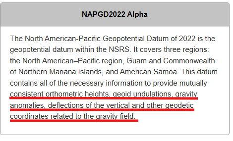
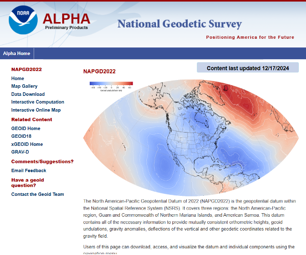
My January 2025 GPS World newsletter mentioned that the National Geodetic Survey (NGS) made several updates to the North American-Pacific Geopotential Datum of 2022 (NAPGD2022) products and that these updates are now available on the NGS alpha site. NGS held a webinar on Jan. 9, 2025, to discuss NAPGD2022 and explain the product updates. I highlighted the NGS Alpha site and GEOID2022 — a product of the NAPGD2022 — in my July 2024 newsletter.
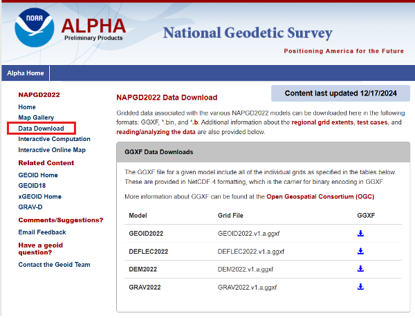
This newsletter will highlight the NAPGD2022 alpha site and the components on the Alpha site — GEOID2022, DEFLEC2022, DEM2022 and GRAV2022. See below for a description of the site.
NGS users of the new National Spatial Reference System (NSRS) should determine the impact on their products and services. For example, the effect of using NAPGD2022 orthometric heights instead of the North American Vertical Datum of 1988 (NAVD 88) on flood plain maps and FEMA elevation certificates.
I have experience dealing with the impact of products and services changing from one national vertical datum to another. When I worked for NGS, I was the Project Manager of NAVD 88. The adjusted heights from the NAVD 88 general adjustment were officially published on June 15, 1991. Performing the adjustment of NAVD 88 was a relatively simple task compared to implementing of NAVD 88 in geospatial products and services in the United States. I wrote articles and talked about the change in the datum from the National Geodetic Vertical Datum of 1929 (NGVD 29) to NAVD 88 at surveying and mapping conferences several times a year during the decade before the completion of the adjustment. Many users were still surprised by the change and the impact on their products and services. It’s a little different today because there are more ways of getting the word out in today’s digital world, such as webinars, Zoom meetings and digital magazines. That said, users still need to participate in webinars and Zoom meetings and read digital articles to understand the changes to geospatial products and services.
Users can download gridded files of the models to create their own routines to analyze the models in their region.
Photo: NGS
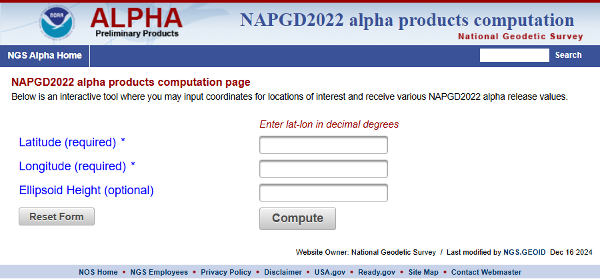
The site provides an option for users to perform single point interactive computations.
Single point interactive computations. (Photo: NGS)
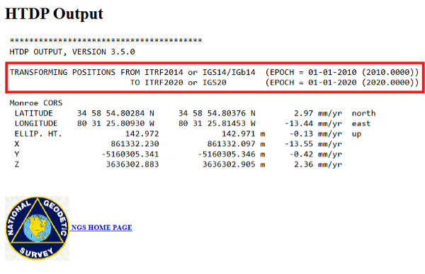
The differences between the ITRF 2014 (epoch 2010.0) coordinate and ITRF 2020 (epoch 2020.0) in North Carolina are not very large. Still, I used NGS’s HTDP tool to transform the North Carolina Monroe CORS (NCMR) ITRF 2014 (epoch 2010.0) coordinates to ITRF 2020 (epoch 2020.0) and then entered the transformed values into the interactive tool. See the images “HTDP Output for NCMR” and “Interactive Computation Page” for an example of the output of the single-point interactive computation tool.
HTDP output for NCMR. (Photo: NGS) Photo: NGS
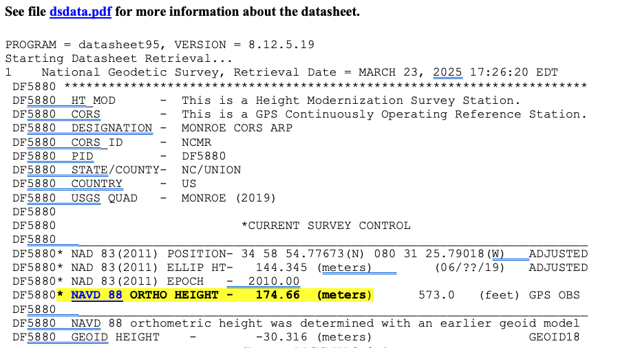
I have highlighted the NAPGD2022 orthometric and dynamic heights for NCMR CORS. I downloaded the latest NGS datasheet for the North Carolina Monroe CORS (NCMR) to obtain the published NAVD 88 height. See the image below.
NGS data sheet for Manroe CORS. (Photo: NGS)
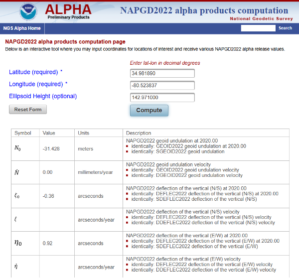
In my example, the difference between the NAPGD2022 and NAVD 88 orthometric height is -0.26 meters (174.40 m – 174.66 m). It should be noted that the tool also provides a dynamic height for the mark. Dynamic heights are used by the International Great Lakes Datum (IGLD). My August 2021 GPS World Newsletter provides more information on the update to the IGLD 85 and dynamic heights. The interactive computation page tool also provides the GEOD2022 value for the mark. The difference between GEOID2022 and GEOID18 for the mark is -0.112 meters (-31.428 minus -30.316).
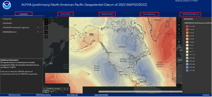
The alpha site provides an option to use an interactive online map that allows users to access GIS maps that depict individual models. I have highlighted the five layers on the box titled “NAPGD2022 Interactive Online Map” – GEOID2022, SDEFLEC2022, GRAV2022 (RBA), Geoid Differences, and NAPGD2022 Differences.
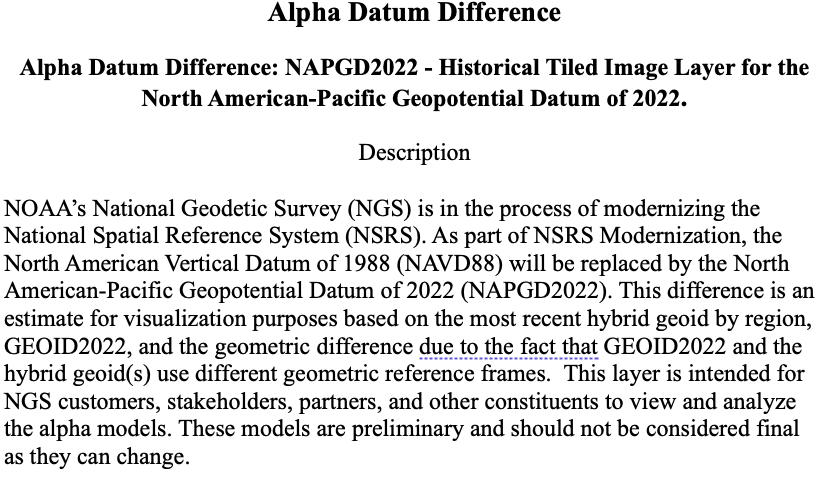
To demonstrate the online maps, I clicked on the layer titled “NAPGD2022 Difference” located in the upper right corner of the of the map. The image below provides a description of the layer.
Photo: NGS
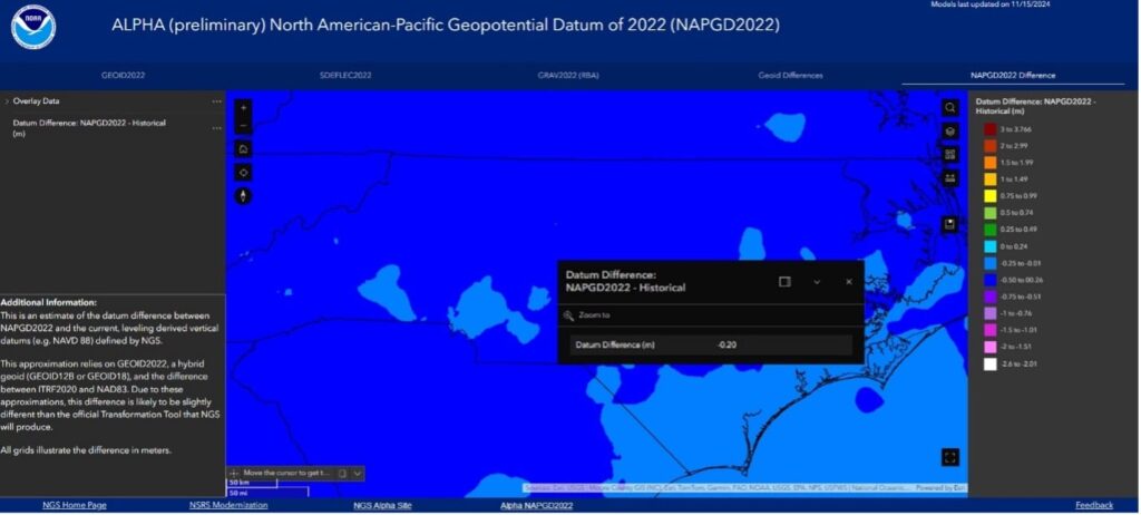
Users can click on the map, and the pop-up provides information about the location. In the example below, the popup provides the difference between the NAPGD2022 orthometric height and the NAVD 88 height.
The difference between NAPGD2022 orthometric height and NAVD 88 height. (Photo: NGS)
Additional information about a layer is provided on the lower left side of the map page.
Additional information for NAPGD2022 difference. (Photo: NGS)
NGS’ online maps didn’t depict the details I wanted to visualize, so I downloaded the data and created my own maps.
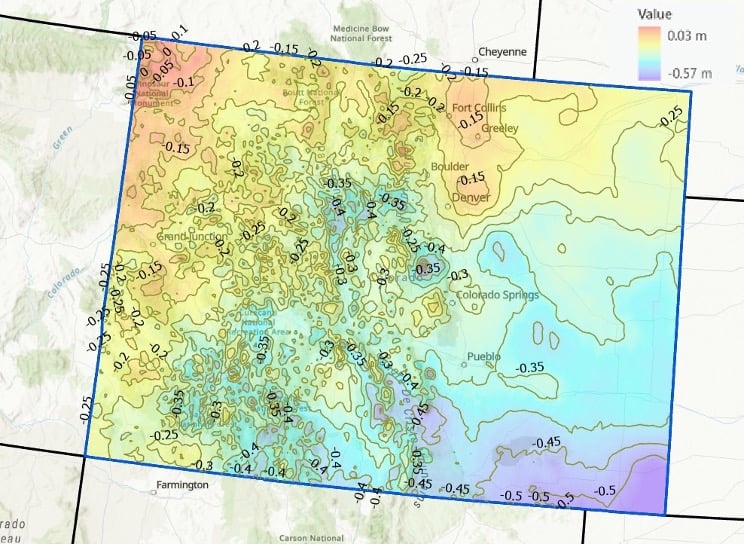
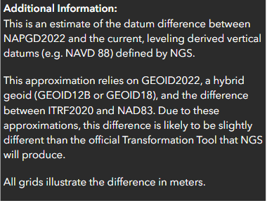
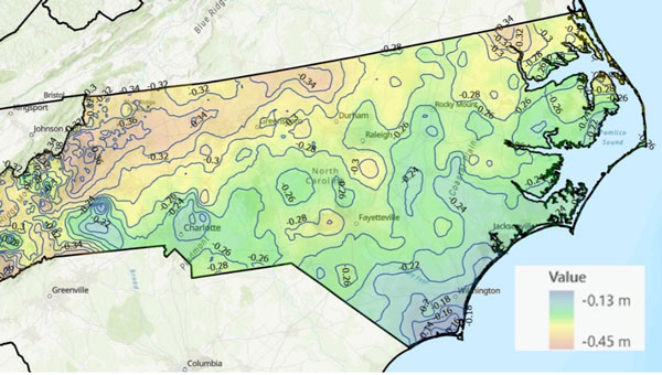
I provided a couple of examples of the differences between NAPGD2022 and NAVD 88 below: one for North Carolina and one for Colorado. As you can see from the plots, there are significant relative differences in mountainous regions (western North Carolina and western Colorado), and a lot of local variation across the state.
Differences between NAPGD 2022 orthometric heights and NAVD 88 in North Carolina (2 cm contour intervals). (Photo: Dave Zilkoski) Differences between NAPGD 2022 orthometric heights and NAVD 88 in Colorado (5 cm contour intervals). (Photo: Dave Zilkoski)
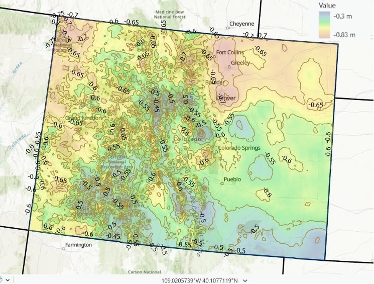
I used the same process to determine the differences between GEOID2022 and GEOID18. See the images titled “Differences between GEOID2022 and GEOID18 in North Carolina” and “Differences between GEOID 2022 and GEOID 18 in Colorado.” Again, it should be noted that there is a lot of variation across the state.
Differences between GEOID2022 and GEOID18 in North Carolina (2 cm contour intervals). (Photo: Dave Zilkoski) Differences between GEOID 2022 and GEOID 18 in Colorado (5 cm contour intervals). (Photo: Dave Zilkoski)
In summary, in a few months, NGS will be releasing a Beta version of the new terrestrial reference frames and geopotential datum. This newsletter highlighted the NAPGD2022 alpha site and the components on the Alpha site — GEOID2022, DEFLEC2022, DEM2022, and GRAV2022. I did a 4-part series in my GPS World newsletters in 2017 on the products of NAPGD2022 (June 2017, August 2017, October 2017 and December 2017).
Unicore has introduced the UM981 series, a high-precision positioning module that integrates RTK and inertial navigation system (INS) technologies. The solution leverages GNSS and INS navigation to cater to applications in precision agriculture, surveying and mapping.
The module is compatible with all major navigation systems and frequencies, tracking signals from multiple systems simultaneously for enhanced performance even in challenging environments. Additionally, the UM981 series supports open Precise Point Positioning (PPP) services such as BDS-3 PPP-B2b, Galileo E6 HAS and QZSS L6 MADOCA-PPP, achieving 10 cm positioning accuracy with a convergence time of under 10 minutes, according to Unicore.
The UM981 series processes high-frequency GNSS and IMU data streams efficiently, offering RTCM data transmission at up to 20 Hz, single-point positioning and RTK at up to 50 Hz and integrated navigation data and IMU raw data at up to 100 Hz. These capabilities make it suitable for dynamic scenarios requiring high precision.
In precision agriculture, the UM981 module simplifies machinery auto-steering systems by enabling single-antenna positioning and attitude determination through advanced MEMS technology. At speeds above 1 km/h, it achieves heading accuracy better than 0.3° and roll/pitch measurements better than 0.2°, with accuracy improving as speed increases. The module supports CAN Bus communication and can be customized to work with the ISOBUS Protocol, eliminating the need for switching between interfaces during serial port communication.
For surveying and mapping applications, the UM981S variant delivers high-accuracy positioning and tilt measurement using GNSS and INS fusion algorithms. It eliminates traditional shake-to-start requirements with a walk-and-go feature that allows users to initialize tilt measurement simply by walking with the measurement pole. The module provides 2.5 cm accuracy within a 30° tilt range and supports measurements at larger angles up to 120°, making it suitable for complex environments such as building corners or areas under tree canopies.
ComNav Technology has revealed the LS600, a handheld 3D laser scanner that integrates SLAM technology, a built-in RTK module and dual 16MP wide-angle cameras. The device employs multi-sensor fusion, including lidar, IMU and cameras, to deliver high performance in both indoor and outdoor environments. It offers 16- or 32-line lidar options, with a scanning range of up to 300 m and a speed of 640,000 points per second for rapid data collection.
The LS600 features an advanced GNSS module that provides centimeter-level accuracy with full-frequency GNSS support. A built-in surveying antenna enhances signal reliability. The dual-lens camera, combined with visual SLAM (V-SLAM), produces detailed color point clouds for realistic and precise visuals. The scanner supports both backpack and pole configurations, making it versatile for applications such as land surveying, engineering, urban renewal, mining, agriculture, forestry and emergency response.
Its automated post-processing capabilities — such as stitching, denoising, and rendering — along with flexible coordinate systems streamline workflows and ensure accurate results. This design allows professionals to achieve precision and efficiency in the field.
ComNav Technology has upgraded its Survey Smart software, enhancing its power, user-friendliness, compatibility, file sharing capabilities, CAD engine and surveying performance.
The update introduces a new user interface optimized based on user habits. It features a new visualization interface, a restructured CAD layout and a flexible toolbar that consolidates common functions across scenarios.
ComNav’s self-developed core component, CADX, has been upgraded to enable instant loading of large drawings for smooth operation. The SinoGeoX feature seamlessly integrates CAD with maps. A new Standing Survey feature has been added to the IMU mode. When activated, it automatically measures points after the receiver remains stationary for 2 seconds, eliminating the need for manual clicks.
File sharing capabilities have been enhanced, allowing files to be downloaded via QR code scanning on handheld collectors or other devices. One-click transfers between collectors, smartphones, and PCs enable cross-platform collaboration and rapid sharing.
The software also now includes RTK PPP Fusion, which seamlessly switches to PPP solutions when RTK signals drop. This maintains operational continuity with PPP accuracy up to 20 cm. It supports echo sounders for precise depth data and WMS services for synchronized, customizable map data.
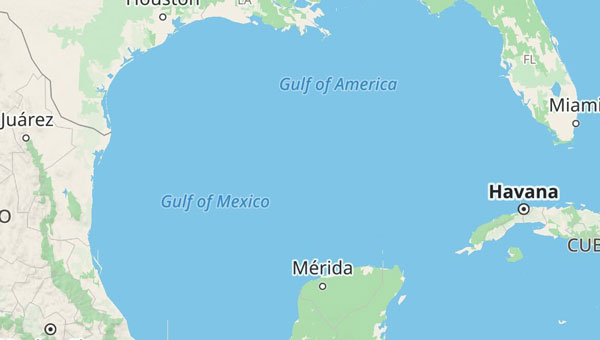
With the United States now recognizing the Gulf waters as the “Gulf of America” and not the “Gulf of Mexico,” digital map creators are deciding how best to reflect the name change for their users.
TomTom, for example, is introducing a U.S. geopolitical view for its users in the United States; they will see “Gulf of America.” Translations will be available in English, Spanish, French and German, and users searching for “Gulf of Mexico” will find the “Gulf of America.” Map users outside of the United States will see the default map view showing the “Gulf of Mexico.” Users searching for “Gulf of America” will find the existing “Gulf of Mexico” feature. All users will be able to change the view based on their preferences.
The company also expects to update its APIs, such as Search API, Geocoding API and Map Display APIs.
TomTom says its decisions are based on how the Geographic Names Information System and the International Hydrographic Organization view the name change.
Read a roundup of recent products in the GNSS and inertial positioning industry from the March 2025 issue of GPS World magazine.
Surveying and Mapping
Photo: Eos Positioning Systems
New Eco-Friendly Carrying Case For Eos Positioning Systems’ receivers
The Skadi Gold, Skadi 300 and Skadi 200 GNSS receivers will now be shipped in a field-rugged carrying case made entirely from recycled materials. The case is designed to meet the demands of professionals who utilize GNSS technology in challenging environments. Its construction incorporates durable, eco-friendly materials that can withstand various field conditions, from remote wilderness areas to urban construction sites.
A key feature is its composition of 100% post-consumer recycled resin, which significantly reduces waste and promotes environmental sustainability, according to the company. It is specifically engineered to be shock-resistant and weatherproof.The case is provided as a standard inclusion with every purchase of the Skadi Gold, Skadi 300 or Skadi 200 GNSS receivers at no additional cost.
Multibeam Sonar Designed for bathymetric surveying
The Gemini 1200id is built on the same robust platform as the Gemini 720is multibeam sonar. The device features a 120° horizontal field of view, operating at both 720 kHz and 1,200 kHz acoustic frequencies.
The Gemini 1200id incorporates advanced noise reduction technology to significantly improve the attenuation of waterborne electrical noise to enhance imaging performance. An integrated speed-of-sound sensor ensures high positional accuracy of displayed targets, while CHIRP processing technology enhances target separation over extended ranges.
Compatibility with Tritech’s Genesis software package allows users to control multiple Tritech products from a single interface to streamline operations. The company has also made software development kits available for Windows and Linux operating systems to integrate into various platforms. The sonar’s design includes a custom-developed analog front-end solution with fully differential receiver channels, making it ideal for longer-range applications.
HiPer XRa is a GNSS receiver for surveying, mapping and construction applications. It can benefit a wide variety of users, including construction professionals, surveyors, geographic information systems (GIS) professionals, archeologists, engineering firms and more. The HiPer XR supports GPS, GLONASS, Galileo, BeiDou, IRNSS, QZSS and SBAS.
The new receiver has advanced Topcon Integrated Leveling Technology (TILT) compensation, featuring a calibration-free and magnetic interference-immune integrated IMU that provides up to 60° of tilt for precision measurements in challenging positions. It has signal integrity protection, anti-jamming and anti-spoofing capabilities. Through the myTopcon NOW! website, users can access online training materials, firmware updates and additional software resources.
Airborne Lidar System Ideal for coastline and river surveying
CoastalMapper is an airborne bathymetric lidar system for coastline and river surveying. The CoastalMapper can survey coastlines and rivers 250% faster than previous sensor models, according to Leica Geosystems.
It is suitable for various mapping applications, from assessing infrastructure resilience to monitoring river floods and conducting environmental investigations.
It features a high-performance bathymetric lidar module, a Leica TerrainMapper-3 topographic lidar and an imaging sensor, integrated into a compact and lightweight sensor head. This allows the CoastalMapper to capture up to 1 million bathymetric data points and 2 million topographic data points per second while providing high-resolution imagery with a 5-cm ground sampling distance at typical flying heights.
It integrates with Leica Geosystems’ airborne mapping workflows and offers cluster processing capabilities, allowing users to analyze large datasets and reduce the time from data collection to final deliverables. These outputs can include classified point clouds, digital terrain and surface models, and various imaging products.
Surveying Kit Streamlines base station and checkpoint setup
WingtraGROUND, a comprehensive survey kit, streamlines base station and checkpoint setup for on-site post-processing kinematic surveys with the WingtraONE Gen II, a vertical takeoff and landing UAV. The kit combines receivers, checkpoints and tools into a single, portable workflow.
The system integrates hardware components with a Wingtra tablet interface, which can help surveyors confirm correct receiver placement and avoid common errors associated with improper base station setup and inaccurate coordinates.
Wingtra receivers, equipped with Emlid Reach RS3 technology, provide accuracy within 2 cm, meeting high standards for aerial data validation. These receivers can also function independently for terrestrial surveys in real-time kinematic mode, including point collection and stakeout for various applications.
Galileo HAS-Enabled Receiver Offers positioning capabilities with 20 cm accuracy
The Geode GNS3H supports Galileo High Accuracy Service (HAS). It offers positioning capabilities with 20 cm accuracy worldwide without requiring additional infrastructure or subscriptions.
It is built to withstand tough conditions, making it ideal for demanding fieldwork. The device offers various accessories, including the Geode Grip, which combines the Geode with a data collection device of choice into a single handheld solution. A backpack strap kit and survey pole are also available to enhance mobility and flexibility in the field. The GNS3H can be used for surveying, agriculture, construction, forestry, mining and archaeology.
Expanded Mapping Portfolio 3D mapping technologies and more
Topcon Positioning Systems has become an authorized distributor of Pix4D’s photogrammetry software portfolio.
The partnership aims to enhance reality capture solutions across various industries, including surveying, mapping, utilities infrastructure, public safety, forensics, and architecture, engineering and construction.
The agreement streamlines the procurement process for end users by allowing them to access Pix4D’s advanced photogrammetry software solutions through Topcon’s global distribution network.
The GNSS real-time kinematic (RTK) 5 Click — a compact add-on board for high-precision positioning and navigation demands — features the UM980, an all-constellation multifrequency RTK positioning module from Unicore, with the advanced NebulasIV SoC for enhanced performance.
It supports Swift Navigation’s Skylark precise positioning service, multiple GNSS constellations and RTK positioning for centimeter-level accuracy. The board also features JamShield technology for robust performance in challenging environments, USB connectivity for easy configuration and visual status indicators for module status and GNSS signal reception.
It can be used for a variety of applications, including surveying and mapping, precision agriculture, UAVs, autonomous robots and autonomous driving.
Multi-Band GNSS Antenna Can operate in urban environments
Levity Series’ AHP24510 (L1/L2/L-Band) and AHP54510 (L1/L5/L-Band) directional patch antennas are designed to receive signals from GPS, Galileo, GLONASS and BeiDou satellite constellations.
These antennas offer faster and more accurate signal acquisition and lock, specifically in urban environments. The L-Band capability allows compatibility with high-precision GNSS correction services. The multi-band antennas offer integral redundancy to minimize satellite security blind spots and reduce energy consumption due to faster acquisition, requiring less system uptime to save power.
The Levity Series active antennas feature a 45 mm x 45 mm x 10 mm wide-band, dual-stacked patch design with a dual-feed, low noise amplifier, providing 28 dB to 29 dB gain and filtering. They operate with a maximum antenna VSWR of 1-to-1 from 1,207 MHz to 1,603 MHz, and the passive antenna efficiency ranges from 39.93% to 68.51% in the L1 band. These antennas use right-hand circular polarization to mitigate multi-path interference.
The Levity Series includes other multi-band products for high-precision applications, such as the HP24510A and HP54510A stacked-patch passive components, and the TFM.120A surface-mount front-end module, which covers the full multi-band GNSS spectrum including L-band. These antennas are suitable for various applications, including wearables, transportation, robotics, precision agriculture and autonomous vehicles.
The M9PLUS-HCT-A-SMA is an active multi-frequency GNSS antenna designed for high-accuracy applications. It supports L1/L2/L5 GPS, Galileo, Beidou and GLONASS bands, as well as L-band correction services. The antenna utilizes Maxtena’s proprietary Helicore technology, which offers advanced pattern control, polarization purity and efficiency in a compact form factor.
It integrates a pre-filter specifically engineered to mitigate LTE interference. This is crucial for maintaining signal integrity in environments with dense mobile communication networks, where LTE signals can overlap with GNSS frequencies. The pre-filter can effectively block out-of-band LTE signals, reducing intermodulation risks and ensuring clear GNSS signal reception.
The M9PLUS-HCT-A-SMA is built with rugged, IP67 automotive-grade components and includes an integrated SMA connector. It also features an O-ring for enhanced environmental sealing. Weighing only 24 grams, the antenna is ground plane-independent, making it versatile for various installations. It is particularly well-suited for GIS and RTK applications where high accuracy and reliability are crucial.
The MostaTech G321M is a three-axis fiber optic gyroscope (FOG) that offers high-precision navigation and orientation measurement capabilities. This advanced sensor features a data rate of 8 kHz.
Key features of the G321M include an input range of 400° per second, a bias RMS of 1° per hour and an angular random walk of 0.025 °/√h. Additionally, it has a power consumption of 2 W and an initialization time of 1 second. The G321M is designed with a compact form factor, making it suitable for various applications where size and weight are critical factors.
It is ideal for UAVs, robotics, borehole surveys, image stabilization, gimbal stabilization and underwater vehicles.
High-Precision Lidar Designed for precision applications
The TV1 Lite and the TV1 UAV systems are designed for various precision applications, such as mapping and data collection.
The TV1 Lite features TrueNav technology, a Hesai 32-channel laser scanner and a FLIR 5MP global shutter camera with a 90° field of view. It also includes one year of TV1 Lite Annual Processing with support and maintenance.
TV1 offers customization options, allowing users to choose from 26 MP, 45 MP or 61 MP cameras and various Trajectory Correction Service options.
Flight Control System With autopilot functionality
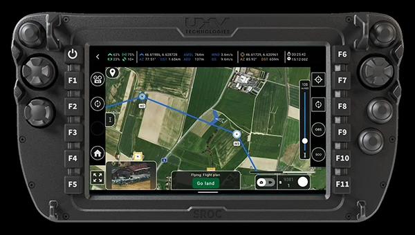
The Prism Supervisor software combines UAV autopilot flight control systems with AI-based observations processed in real time, aiming to enhance UAV operations.
The system provides a programming framework and software development kit for users to create custom mission scenarios. During flight, Prism Supervisor can adapt its autopilot functionality in real time, generating mission segments and flight plans as needed.
The software features a user-friendly graphic interface for mission planning, real-time visualization and execution. It supports Windows, Linux, macOS, iOS and Android.
Remote ID Receiver Enhances airspace awareness and UAV safety
RIDER is designed to enhance situational awareness by providing real-time detection of UAV activity in sensitive areas. It also seeks to provide a clear visibility of surrounding UAV operations to help avoid potential collisions and ensure safer flight experiences.
The device features a built-in industrial chip SIM that provides global coverage through LTE-M and NB-IoT, ensuring connectivity in various environments.
It operates effectively within a temperature range of -20 °C to +60 °C and is rated IP54 for dust and water resistance. The device complies with ASTM F3411-22A and ASD-STAN EN 4709-002 standards, making it suitable for regulatory environments.
The RIDER can detect signals from up to 5 km with its default antennas and up to 10 km when using an optional high-performance antenna. It is equipped with an internal cellular and Bluetooth antenna, along with an integrated GNSS antenna that provides precise positioning and timestamping capabilities. It supports multiple GNSS frequencies and utilizes Bluetooth and Wi-Fi technologies for Remote ID communications.
Streamlined BVLOS Operations For a variety of applications
The Sentaero 6 UAV is designed for advanced over-the-horizon operations beyond visual line of sight (OTH-BVLOS). It features built-in AI and machine learning capabilities for real-time data processing. The system can be used for surveying, mapping, inspection, asset monitoring and more.
Engineered to streamline operations, the Sentaero 6 offers more accurate and up-to-date intelligence on assets. Its onboard computer can processes data mid-flight.
Future developments will include swarm operations, enabling one human to control multiple UAVs simultaneously; fully remote operations and higher safety standards, such as a parachute for urban missions, according to Censys Technologies.
SBG Systems has significantly updated its Ellipse series sensors, incorporating the latest World Magnetic Model (WMM) to enhance accuracy and reliability in navigation applications. This upgrade is available for all Ellipse sensors, including first-generation models.
Designed for unmanned systems such as UAVs, UGVs and marine platforms, the Ellipse series comprises compact, high-precision inertial sensors. These devices feature built-in three-axis magnetometers that measure Earth’s magnetic field, crucial for accurate heading and positioning data.
Updated every five years, the WMM is a globally recognized mathematical representation of Earth’s magnetic field. The latest version, released in December 2024, ensures precise heading and positioning corrections to account for ongoing geomagnetic changes.
NDAA-Compliant UAV Now integrated with ArcGIS Flight
Esri now supports the Astro Max UAV in its ArcGIS Flight application. The Astro Max is the first Blue UAS-cleared and NDAA-compliant UAV to integrate with Esri’s platform.
The Astro Max, developed by Esri partner Freefly Systems, adheres to the security and performance standards set by the National Defense Authorization Act and the Defense Innovation Unit’s Blue UAS initiative. This industrial UAV is designed to enhance the capabilities of government and enterprise users utilizing ArcGIS Flight.
Autonomous Swarm Control Controls various autonomous platforms
The Autonomous Multi-Domain Operations Resiliency Platform for Heterogeneous Unmanned Swarms (AMORPHOUS) software features a single-user interface to operate thousands of autonomous assets simultaneously. Designed with an open architecture, this software enables the U.S. and allied militaries to control a mix of uncrewed platforms, payloads and systems.
AMORPHOUS includes an intuitive and distributed command-and-control interface to give operators the flexibility to conduct a wider array of intricate military missions. This collaborative autonomy at scale will provide warfighters with a decisive overmatch capability.
L3Harris is developing prototypes using the AMORPHOUS architecture on contracts for the U.S. Army and the Defense Innovation Unit. AMORPHOUS has demonstrated flexibility and interoperability by controlling multiple, separate assets across multiple vehicle types operating in different domains during government-managed tests.
AMORPHOUS supports decentralized decision-making, which enables individual, uncrewed assets to perform tasks autonomously and make real-time tactical decisions inside the network.
Advanced Counter-UAV Radar Multi-console radar control and display system
Cambridge Pixel has developed a radar control and display system for Weibel Scientific’s XENTA surveillance radar, which is designed for modern air defense and counter-unmanned aerial systems (C-UAS) applications.
The XENTA radar includes 3D target tracking, continuous target illumination and synthetic receiver beamforming. It is available in two configurations: the XENTA-M for short-range air defense and the XENTA-C for C-UAS operations.
The system is designed to work seamlessly with third-party command-and-control systems, enhancing operational efficiency.
Cambridge Pixel’s library of radar processing software allows users to develop a tailored radar controller specific to the XENTA radar’s requirements. Enhancements were made to existing functionalities, such as improved MIL-STD-2525 overlay graphics and support for dual-redundant operator consoles.
The XENTA radar system can detect small UAVs at distances exceeding 7 km and classify them beyond 5 km. This capability makes it suitable for various applications, including airport security, border control, critical infrastructure protection and event security.
The Pelican 2 agricultural spray UAV has an expanded 300-liter payload capacity and can cover up to 5.3 ha/hr.
It incorporates several technological enhancements designed to meet the demands of agriculture applications. The aircraft features an upgraded four-motor electric propulsion system, a wider 18-m spray swath and advanced lidar and radar systems for fully autonomous day-and-night spraying. These improvements aim to increase efficiency and precision in aerial application while reducing operational costs for farmers.
The Pelican 2’s airframe and structural components are constructed from carbon fiber composites, corrosion-resistant metallic components and 3D-printed assemblies.
DJI has introduced the DJI Dock 3, its first “drone-in-a-box” solution designed for vehicle-mounted deployments and 24/7 remote operations in various environments. This system is compatible with the Matrice 4D and Matrice 4TD UAVs, which feature advanced cameras and IP-rated protection for challenging conditions. The UAVs are ideal for public safety, emergency response and infrastructure inspection.
When pre-heated, the DJI Dock 3 can operate in temperatures as high as 50 °C and as low as -30 °C. It is IP56-rated dust and water-resistant to protect its internal systems. The accompanying UAV features IP55-rated protection and low-noise anti-ice propellers to ensure stable flights in freezing rain or winds up to 12 m/s.
This system supports flexible deployment options, including vehicle-mounted setups optimized for emergency operations and long-distance inspections. It enables horizontal calibration and cloud-based dock location adjustments. For enhanced efficiency, two docks can be mounted on a single vehicle to facilitate dual-UAV rotations. In fixed deployments, the D-RTK 3 Relay Fixed Deployment Version can be added to improve video transmission and satellite connectivity.
The Matrice 4D and 4TD UAVs have a wide-angle camera, medium tele camera, tele camera and laser range finder. The Matrice 4D features an advanced camera suite designed for high-precision mapping. The Matrice 4TD includes an infrared thermal camera for public safety and emergency response applications.
The system also features an airborne relay function using the DJI RC Plus 2 Enterprise controller. This allows one drone to act as a relay to extend the operational range of another drone in areas without a 4G signal or with obstructions, making it particularly useful for search and rescue missions or inspections in mountainous regions.
The DJI Dock 3 integrates seamlessly with DJI FlightHub 2 to enable intelligent aerial operations. Automated flight routes allow drones to capture images or detect anomalies autonomously. Features like intelligent change detection provide periodic analyses of environmental changes, while the Virtual Cockpit interface allows operators to adjust gimbal orientation remotely using the new Mouselook feature.
To support regulatory compliance in strictly controlled airspace, the system includes a Flight Termination System , which can manually or automatically stop drone operations if necessary. Additionally, DJI Care Enterprise Plus offers comprehensive protection plans that include unlimited repairs within coverage limits and battery replacements.
Hexagon | NovAtel has entered into a Memorandum of Understanding (MOU) with GPR, Inc. to integrate GPR’s WaveSense ground-penetrating radar sensors into NovAtel’s SPAN GNSS/INS solution. This collaboration aims to explore the integration of NovAtel’s SPAN system with GPR’s subsurface mapping technology, enhancing positioning solutions for applications requiring high reliability and centimeter-level accuracy, such as autonomous systems, mining and other mission-critical operations.
NovAtel’s SPAN GNSS+INS technology has historically provided reliable position, velocity and attitude (PVA) data by combining GNSS signals with IMU data. This approach ensures continuous accuracy during short GNSS interruptions caused by environmental factors like foliage or buildings. By incorporating WaveSense’s ground-penetrating radar as an additional input, the system can maintain accurate PVA solutions even during extended GNSS outages due to obstructions, signal interference, or jamming. This integration is particularly beneficial in GNSS-denied environments or areas lacking clear surface structures.
WaveSense technology operates by scanning up to 10 ft below the ground to map unique subterranean features. These stable underground patterns serve as a reliable reference for navigation, unaffected by adverse weather conditions such as snow, rain or fog. The combination of SPAN and WaveSense technologies is expected to significantly enhance navigation accuracy and reliability in challenging environments, according to the company.
Under the terms of the MOU, NovAtel and GPR will collaborate on specific use cases to demonstrate the combined capabilities of SPAN and WaveSense in demanding applications. Following these demonstrations, the partnership may advance toward a full product definition and supply agreement, according to the companies.