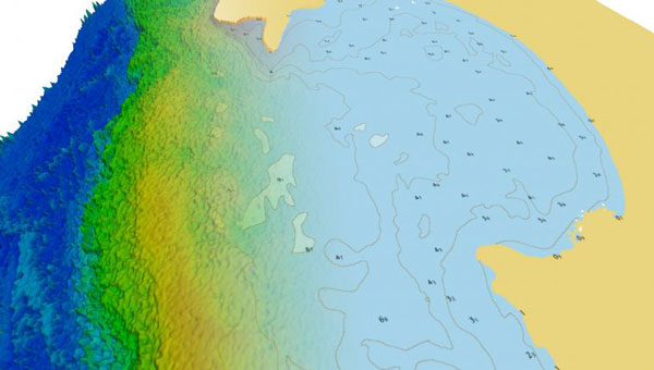
TCarta has introduced a new line of Satellite Reconnaissance Charts designed to complement official marine navigation maps in shallow waters. These digital maps, derived from recently acquired satellite imagery, adhere to International Hydrographic Organization S-57 and S-100 data model standards, mirroring the appearance and symbology of official navigation aids.
The TCarta Charts provide up-to-date information on seafloor depths, sandbars, reefs, shoals and other submerged hazards, as well as floating dangers in near-shore environments. The new products are particularly valuable for shallow water navigation, where official nautical map products, primarily designed for commercial shipping lanes, may lack detail.
Available in off-the-shelf 1:20,000 scale and custom 1:4,000 scale, the TCarta Satellite Reconnaissance Charts are delivered in file formats compatible with popular marine navigation software and common GIS platforms. This compatibility ensures easy integration into existing navigation systems.
These charts are designed to serve as a supplementary tool, providing mariners with additional information to navigate potentially hazardous near-shore environments more safely.
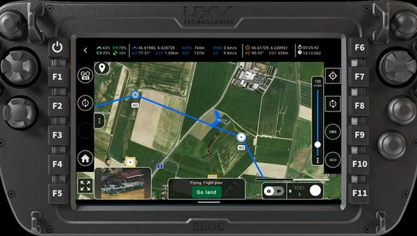
AgEagle Aerial Systems has introduced version 2.1.0 of its eBee VISION application software, designed to significantly enhance UAV capabilities. The update expands the system’s functionality, introducing circular and grid mapping features. These new mapping capabilities allow users to generate 2D or 3D maps using external post-processing software for more comprehensive geospatial data.
eBee VISION 2.1.0 can continue missions in GNSS-denied environments and allows manual deactivation of GNSS to prevent jamming or spoofing. It implements the STANAG 4609 standard, the official format for motion imagery exchange within the NATO nations. This involves embedding UAV position and camera information into the videos recorded by the UAV and those broadcasted by the Ground Control Station. Its inclusion in the system enhances interoperability with third-party applications, which is key for military-grade UAVs.
Another improvement in the software update is the enhanced control over the Silent Tactical Landing feature. Users can now manually adjust the landing position on the map, with the system providing range estimates to inform operators of the UAV’s reach. This functionality offers greater flexibility in mission planning and execution, particularly in tactical scenarios requiring precise landing control.
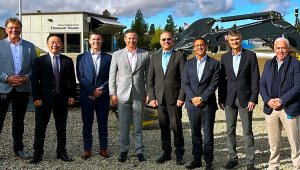
Topcon Corporation and FARO Technologies have entered a strategic partnership to develop and distribute laser-scanning technology solutions. The collaboration aims to expand access to advanced digital reality tools and result in complementary product developments, such as integrating Topcon and Sokkia systems with FARO products.
The initiative focuses on advancing laser-scanning technologies across key sectors, including construction, surveying, mapping, architecture, forensics, building information modeling and industrial plant and process applications. By combining their expertise, the companies plan to enhance software integration and develop joint product solutions to address user needs more effectively.
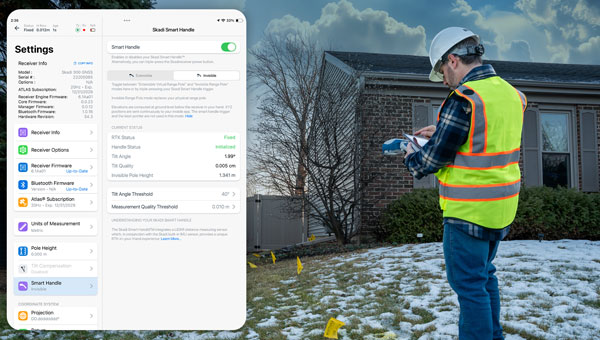
Eos Positioning Systems has launched a redesigned Eos Tools Pro app on iOS. The updated app features a modern user interface and user experience to enhance usability, functionality and efficiency for professionals using Eos GNSS technology.
The redesigned app includes a reorganized settings menu to improve the organization of all configuration options, offering a centralized space for users to manage their GNSS preferences and optimize workflows. The new interface has been revamped to take advantage of Split View mode on iPadOS to view all pertinent information when using Eos Tools Pro in conjunction with a data-collection app. This is particullarly useful for Skadi Tilt Compensation and Skadi Smart Handle users.
Topcon Positioning Systems has become an authorized distributor of Pix4D’s photogrammetry software portfolio, expanding access to high-precision positioning and 3D mapping technologies.
The partnership aims to enhance reality capture solutions across various industries, including surveying, mapping, architecture engineering and construction, energy, utilities infrastructure, public safety, and forensics.
The agreement streamlines the procurement process for end-users by allowing them to access Pix4D‘s advanced photogrammetry software solutions through Topcon’s established global distribution network and ensures comprehensive technical support for users.
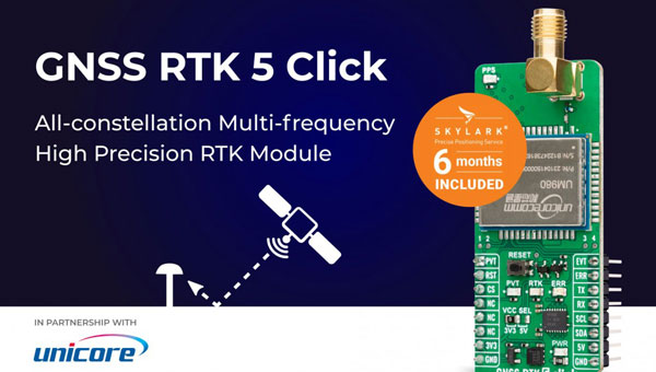
MIKROE has unveiled the GNSS RTK 5 Click, a compact add-on board for high-precision positioning and navigation demands. It features the UM980, an all-constellation multifrequency RTK positioning module from Unicore, with the advanced NebulasIV SoC for enhanced performance.
It supports Swift Navigation’s Skylark precise positioning service, multiple GNSS constellations, and RTK positioning for centimeter-level accuracy. The board also features JamShield technology for robust performance in challenging environments, USB connectivity for easy configuration and visual status indicators for module status and GNSS signal reception.
It can be used for a variety of applications, including surveying and mapping, precision agriculture, UAVs, autonomous robots and autonomous driving.
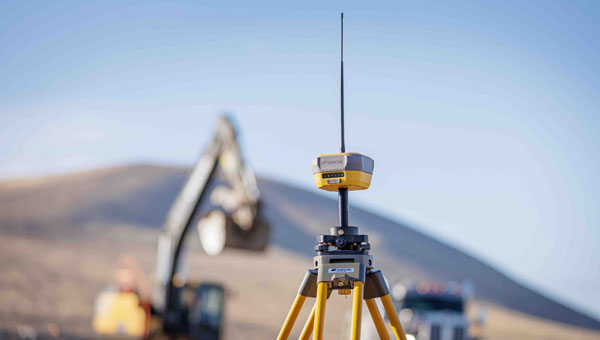
Topcon Positioning Systems has introduced the HiPer XRa GNSS receiver for surveying, mapping and construction applications. The new receiver is designed to benefit a wide variety of users, including construction professionals, surveyors, GIS professionals, archeologists, engineering firms and others who rely on quality, precision measurements. The HiPer XR supports GPS, GLONASS, Galileo, BeiDou, IRNSS, QZSS and SBAS.
The new receiver has advanced Topcon Integrated Leveling Technology (TILT) compensation, featuring a calibration-free and magnetic interference-immune integrated IMU that provides up to 60° of tilt for precision measurements in challenging positions. It has signal integrity protection, anti-jamming and anti-spoofing capabilities designed to keep data reliable, even in areas with interference or degraded signals.
Through the myTopcon NOW! Website users can access online training materials, firmware updates, and additional software resources.
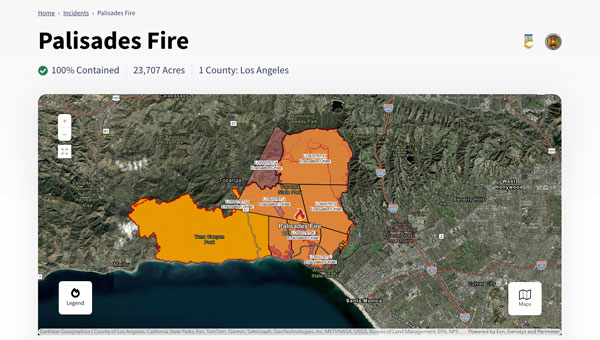
The Palisades and Eaton fires devastated parts of Los Angeles in January 2025 and are largely contained as of Jan. 20. Fueled by extreme Santa Ana winds and dry conditions, these fires have left a mark on the region’s landscape and community.
The Palisades Fire, which originated in the Pacific Palisades on Jan. 7, ultimately burned 23,448 acres, resulted in 12 confirmed fatalities and destroyed or damaged more than 6,800 structures, according to the California Department of Forestry and Fire Protection, known as CAL FIRE. The fire’s rapid expansion was particularly alarming, growing from a small brush fire to a massive conflagration within an hour.
Simultaneously, the Eaton Fire, which began near Altadena and Pasadena, consumed 14,117 acres. This fire proved even more deadly, with 17 confirmed fatalities and significant damage to more than 10,000 structures, according to CAL FIRE. Both the Palisades and Eaton fires have now been classified among the most destructive wildfires in California’s history.
During times of emergency, geographic information systems (GIS) specialists come together to create real-time mapping tools to provide critical support to first responders and keep communities well-informed. These tools have become indispensable in modern disaster management, particularly in wildfire response.
Interactive 3D Maps
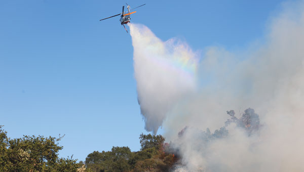
Firefighters and other specialists from federal, state, and local agencies work together to fight wildfires. GIS specialists develop interactive 3D maps to display fire perimeters, evacuation zones and other critical data. The geospatial data serves as the foundation for effective communication and decision-making, allowing firefighters and incident management teams to access information in near real-time to make informed decisions.
Fire GIS specialists Peter Rowland, Brett Adler and Dawn Hutchinson shared insights into their teams’ strategies for wildfire management. They emphasize the crucial role of geospatial tools in disaster response by delivering actionable intelligence. GPS World interviewed them during the California wildfires. Rowland and Adler were based at the Palisades fire, while Hutchinson, who is a member of a California Interagency Incident Management Team (CIIMT), was located near the Eaton fire.
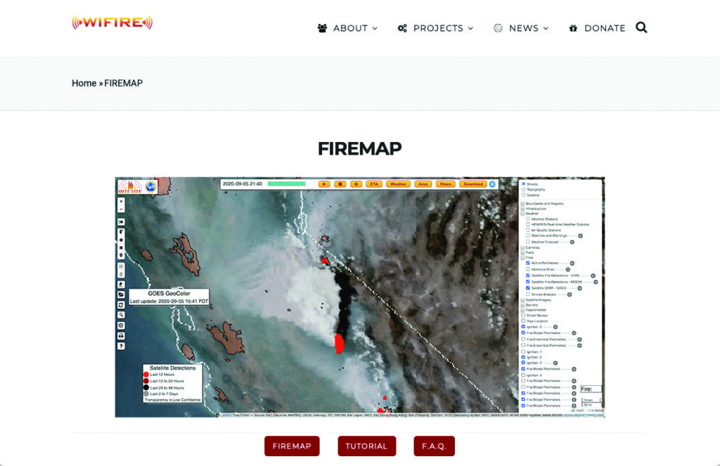
Interagency GIS teams use the Fire Integrated Real-Time Intelligence System (FIRIS) to watch for fire starts and then receive alerts from dispatch centers and satellite imagery. After locating the point of ignition, they create fire behavior models using a program called WIFIRE from UC San Diego. This tool allows them to predict the fire’s probable trajectory and size.
Photo: CAL FIRE
The team will alert the state if the data shows the fire is likely to spread. Hutchinson explains that, within minutes of the start of the Eaton fire, her team produced a fire behavior model that illustrated where the fire was most likely to go and how big it would likely get within the next three hours.
Photo: CAL FIRE
The frequency of IR flights depends on the fire’s size and intensity. Occurring anywhere from once to three times daily, including nighttime, these flights comprehensively map the landscape based on the fire’s specific traits. The decision on how often to fly the planes and collect the IR data depends on the fire’s behavior and potential threat level.
Field observers are also deployed daily to collect data down to the debris. They walk the fire’s edge and move along specific paths created for wildfire management and containment. Once a fire is contained, GIS specialists try to verify ground truth for the perimeter of the entire fire.
GIS specialists constantly update fire perimeters as they get data from the field and the planes. Once a fire is contained, they create final maps to hand over to the local agencies or the Forest Service.
Photo: CAL FIRE
Most of the data that GIS specialists use to map fires comes from field observers and infrared (IR) thermal imagery. The data is collected by third-party contractors, by CAL FIRE’s Intel shift team, or by the FIRIS program by flying manned aircraft.
IR data and information collected by field observers are then uploaded into the National Incident Feature Service (NIFS) for GIS specialists to use to map fires.
Field observers download the maps onto their devices, go out into the field, and ground truth — physically walking the perimeter of the fire and using GPS on their devices to map the fire boundaries accurately.
Photo: CAL FIRE
Paper maps are good to have “just to get everybody on the same page without having to worry about battery life or the glare while you’re working out in the field,” said Rowland.
Along with online maps, the Interagency GIS teams print PDF maps for fire personnel in the field. The field observers use Esri ArcGIS Field Maps to record their tracks. They pair their mobile devices with Avenza or other geolocating applications.
Using ArcGIS Pro, GIS specialists create online maps and dashboards, which are then distributed in print and/or digitally to the agencies that need them, such as sheriff and police departments and departments of public works. The Interagency GIS teams create different map products for different end users. For example, it works with law enforcement to create evacuation maps and zones. Local public information officers also can distribute these maps or post them on their websites.
Photo: CAL FIRE
Crews also have online access to the maps through wildfire FTP (ftp.wildfire.gov). Crews load data and maps there that contain public information. Many agencies plug into the National Interagency Fire Center (NIFC), where the CAL FIRE team edits and analyzes mobile data.
Savvy Navvy has released Savvy Integrated, a comprehensive hardware and software integration platform specifically designed to provide advanced navigation solutions for original equipment manufacturers (OEMs) in the marine industry. This solution combines digital charting technology with hardware integration capabilities, addressing critical navigation challenges for boat manufacturers.
The Savvy Integrated platform provides OEMs with a navigation solution featuring a comprehensive digital marine chart with real-time geographical data and seamless integration with multifunction displays. The platform, which is compatible with a range of marine system architectures, offers extensive depth mapping and navigation details, as well as support for various types and configurations of vessels.
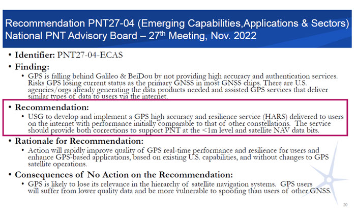
From Dec. 4-5, 2024, the National Space-Based Positioning, Navigation and Timing (PNT) Advisory Board met to discuss GPS-related topics. The PNT Advisory Board provides independent advice to the U.S. government on GPS-related policy, planning, program management and funding profiles in relation to the current state of national and international satellite navigation services. A March 28, 2024, GPS World article by Dana Goward highlighted that the PNT Advisory Board has been providing the government with independent expert advice about GPS and PNT for 20 years. He highlighted that the Board is chaired by retired Admiral Thad Allen and has six subcommittees.
This newsletter will highlight a topic that the emerging capabilities, applications and sectors subcommittee discussed at the final PNT Advisory Board meeting of 2024. The presentation title is “GPS High Accuracy and Robustness Service (HARS).” A white paper on the topic and the Dec. 4, 2024, presentation by Shachak Pe’eri, Ph.D., NOAA/NOS/National Geodetic Survey (NGS), can be found on the PNT Advisory Board website.
According to the document, the board prepared the white paper to support recommendation number PNT27-04-ECAS, which is to develop and implement a GPS HARS delivered to users via the Internet. The HARS concept was approved at the PNTAB-27 meeting (Nov. 16-17, 2022) and formally submitted to the National Space-Based PNT EXCOM co-chairs via Memorandum on Jan. 27, 2023.
Recommendation PNT27-04. (Photo: Presentation by John W. Betz, PhD Member, National Space‐Based PNT Advisory Board on May 29, 2024)
The November and December Advisory Board meetings are recorded, and individuals can listen to the entire meeting. The Board’s website provides links to the meeting agenda and presentations. Pe’eri’s presentation on HARS started at 10:30 am on Dec. 4 (2:04 on the recording).
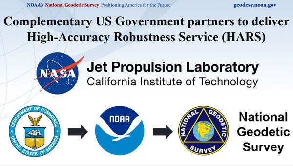
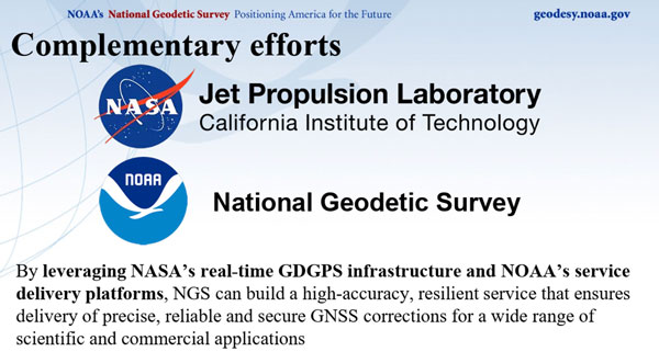
During the meeting, the PNT Advisory Board officially stated that it supports the HARS Concept described by NOAA. Of course, the Board also stated that it has no money, but the Board’s stamp of approval of the concept is very important. Now, it is up to NOAA’s NGS to work with other federal agencies, such as NASA’s Jet Propulsion Laboratory (JPL), to work out the details and resources. By leveraging NASA’s real-time Global Differential GPS (GDGPS) System infrastructure and NOAA’s service delivery platforms, a high-accuracy, resilient service that ensures delivery of precise, reliable and secure GNSS corrections for a wide range of scientific and commercial applications can be built for the nation.
So, what exactly is the GPS High Accuracy and Robustness Service (HARS)? The following is a statement from a Jan. 27, 2023, PNT Memo:
“Implementing a GPS High Accuracy and Robustness Service: To augment GPS and overcome some inherent limitations of space-based PNT, the USG should provide a service comparable to the European Union’s Galileo HAS that provides signal corrections than enable better than one-meter level accuracy, as well as cryptographically-protected satellite navigation message data bits for integrity processing. The U.S. should develop and implement GPS HARS, based on the capabilities developed by the JPL for GDGPS, to be made available to users over the Internet.”
The white paper describes the problem and the solution as the following:
“The problem: GPS is falling behind other Global Navigation Satellite Systems (GNSSs) such as Europe’s Galileo and China’s Beidou. GPS has adopted an approach of allowing augmentation by third-party systems (such as Assisted-GNSS in mobile phones, WAAS for aviation accuracy and integrity, and commercial RTK for precision users), rather than providing specialized advanced services itself. Also, the data message modulated on the GPS signals is fragile. Environmental effects or malicious actions can prevent a receiver from reading the information or manipulate what is read, limiting the robustness of the GPS signals. Currently, GPS is the primary system in almost all GNSS chips, even chips made in Europe or Asia. That is: chips are designed to acquire GPS signals first, then signals from other systems. But Galileo and BeiDou are deploying high accuracy services that provide sub-meter position accuracy, enhancing satnav use in many civil applications. The absence of any plan for GPS to offer a similarly high accuracy service could cause GNSS chips to begin using Galileo or BeiDou, rather than GPS, as the primary system. A switch away from GPS as the primary PNT system is a problem for the US Government because it will lose its strategic advantage. Existing commercial chips are used in many strategically important US assets, such as airlines, ships, and organizations that support the US military. Once these chips change their architecture to Galileo-first or BeiDou-first, these strategic use cases depend on these services. It is one step in the direction of not having a GNSS system at all and borrowing the system of another power, exactly the situation that Europe and China were in before they built their own systems. GPS would no longer be the “pre-eminent space-based PNT service” called for in Space Policy Directive 7.”
“The Solution:A high accuracy and robustness service (HARS) provides information to user receivers, reducing errors and enhancing the ability to operate in challenging conditions. The PNT Advisory Board has identified a solution that the U.S. government can provide a HARS without adding cost and complexity to GPS itself; instead, the needed information from government or government-sponsored organizations can be obtained and provided over the Internet to properly equipped receivers. The result would be a world-class HARS at a small fraction of the cost or time, compared to implementing it on new GPS satellites. The HARS would provide cryptographically-protected robust (resistant to jamming and spoofing) GPS for critical infrastructure and would enable new applications (such as lane-dependent route guidance in automobile navigation and emergency vehicle guidance, GPS-only precision positioning of drones) that extend the societal benefits of GPS. HARS would be secure and less sensitive to radio noise and disruptions, including spoofing.”
The following are a few slides from Pe’eri’s presentation highlighting the need for HARS. He mentioned that there are six regional high accuracy systems and one global service that is already operational or in development.
Six regional HAS and one global HAS are operational or in development at this time. (Photo: NOAA/NGS)
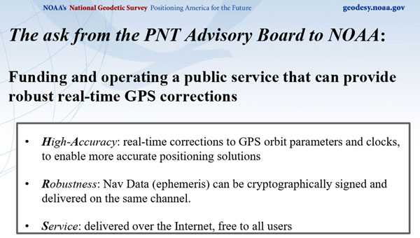
NOAA’s presentation by Pe’eri was in response to a request by the Advisory Board. The Board was interested in learning more about the funding and operating a public service that can provide robust real-time GPS corrections. Summarized in three bullets:
High-Accuracy: Real-time corrections to GPS orbit parameters and clocks to enable more accurate positioning solutions.
Robustness: Nav Data (ephemeris) can be cryptographically signed and delivered on the same channel.
Service: Delivered over the Internet and is free to all users.
The HARS could be accomplished by employing the expertise, knowledge, and capabilities of NASA’s JPL and NOAA’s NGS.
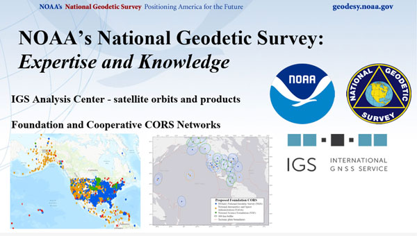
NOAA has the authority to provide real-time operational services and regularly collaborates with other federal and state agencies and local communities. NGS manages and distributes the NOAA CORS Network (Foundation and Cooperative CORS). NASA JPL collects GNSS data and generates products with high accuracy.
NGS expertise and knowledge. (Photo: NGS/NOAA)
NASA’s GDGPS is a complete, highly accurate and extremely robust real-time GNSS monitoring and augmentation system. The CCDIS website states, “Employing a large ground network of real-time reference receivers, innovative network architecture, and real-time data processing software, the GDGPS System provides sub-decimeter (<10 cm) positioning accuracy and sub-nanosecond time transfer accuracy anywhere in the world, on the ground, in the air, and in space, independent of local infrastructure.”
JPL expertise and knowledge. (Photo: NASA)
By leveraging NASA’s real-time GDGPS System infrastructure and NOAA’s service delivery platforms, NGS and JPL can build a high-accuracy, resilient service that ensures delivery of precise, reliable and secure GNSS corrections for a wide range of scientific and commercial applications.
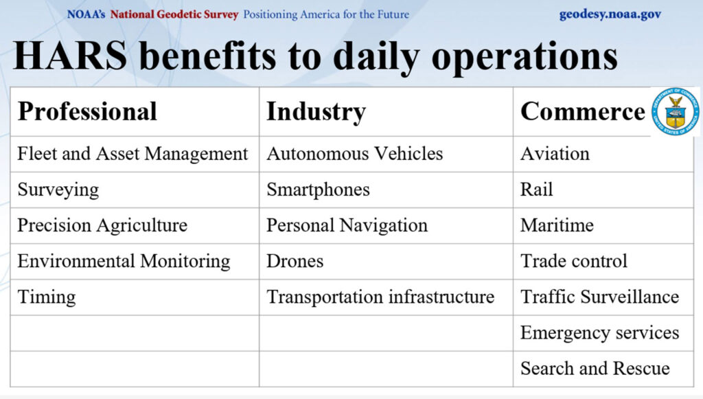
Pe’eri’s presentation highlighted HARS benefits to the daily operations of users of geospatial data.
HARS benefits for users. (Photo: NOAA/NGS)
The HARS concept is extremely important to the U.S. GPS user community, where the number of users is increasing every day. A 2019 Department of Commerce (NIST) study, “Economic Benefits of the Global Positioning System (GPS),” highlighted the economic damages a GPS outage would have on the agricultural industry.
The 2019 NIST study, “Economic Benefits of the Global Positioning System (GPS),” determined that $1.4 trillion in U.S. economic benefits from GPS. The study stated that a 30-day widespread outage could erode less than $1 billion in economic value per day. The study also highlighted the impact a GPS outage would have on Agriculture, stating that during planting season, economic damages in the agriculture sector could increase 30-day losses to $15 billion due to lower yields.
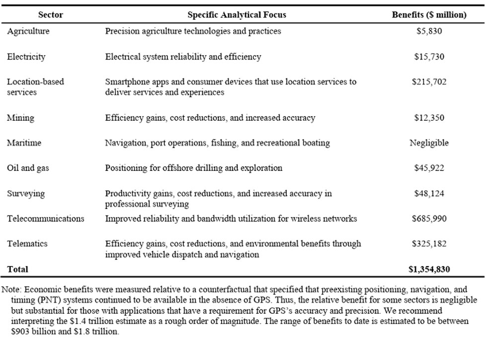
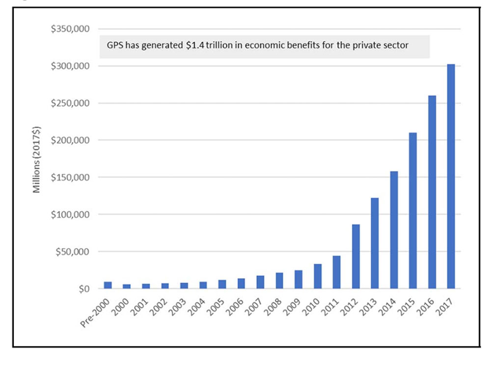
Table ES-1 and figure ES-1 from the 2019 report highlight the economic benefits of GPS for private sector use.
Table ES-1: Summary of economic benefits of GPS for private-sector use, 1984 to 2017. (Photo: NIST) Figure ES-1: Time series of GPS’s economic benefits for the private sector. (Photo: NIST)
I would encourage others to look at the PNT website, especially the Advisory Board website, to obtain information about space-based PNT. Other recommendations and letters from the Advisory Board to the Executive Committee (EXCOM) can be found on the PNT and Advisory Board websites. The webpage provides the Advisory Board’s recommendations on ways to improve GPS and national GPS management. The recommendations are published in the interest of public transparency.
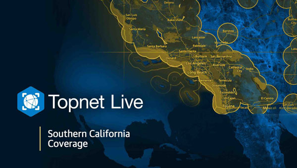
In response to the recent wildfires in Southern California, Topcon Positioning Systems is now offering free access to its GNSS correction services network for emergency recovery efforts. The company is offering a 90-day subscription to its Topnet Live service, which delivers precise positioning data crucial for assessing damaged infrastructure, surveying, utility mapping and operating construction equipment.
The technology is being made available at no cost within affected areas to support first responders, public works teams, and other professionals involved in damage assessment, infrastructure repairs, and rebuilding initiatives. The service is compatible with any brand of receiver capable of using RTCM format NTRIP corrections.
“We want to help the efforts that are ongoing and aid in the future reconstruction of the damaged communities from these wildfires,” said Jason Killpack, director of Topcon emerging business development. “The 90-day emergency subscription service is free to anybody that needs them to get their essential job done.”
Individuals or organizations seeking to activate this service can contact participating Topcon distributors in California. Contact information is available on the company’s website for those interested in utilizing the emergency assistance.
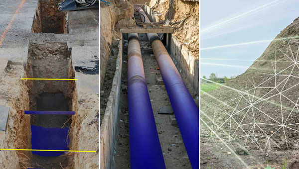
Nearly three quarters of Earth’s surface is covered by water, yet only about a quarter of that surface has been mapped in detail using modern high-resolution technology.
Marine experts worldwide work together to chart the ocean floor, ensuring the safety of ports, harbors and navigable routes. This effort is crucial for global trade, as more than 90% of goods are transported by ships. Ocean floor surveying also supports the installation of offshore infrastructure such as fiber optic cables, pipelines, drilling platforms and wind turbines.
The increasing population in coastal regions and rising sea levels due to climate change have heightened the importance of observing coastal transformations, erosion and other marine alterations. These factors are essential for understanding and protecting coastal ecosystems.
Mapping techniques
In deep waters, massive multi-beam echo sounders (MBES) operating at very low frequencies collect depth data. As water depth decreases, smaller devices with higher frequencies and resolution must be used. However, near the shore, these devices become less efficient due to the slope of the shelf interfering with sound signals.
In near-shore scenarios, collecting depth data is best done using airborne lidar sensors, which offer several advantages over sensors on surface vessels. One advantage of airborne sensors is that they can simultaneously map both the seafloor and the adjacent topography to offer seamless land-water transition data. This capability is particularly valuable in dynamic coastal environments where rapid coverage of large areas is essential.
Bathymetric lidar is specifically designed for mapping shallow coastal waters, typically effective up to depths of 50 m. It can provide high-resolution data, often achieving sub-meter positional accuracy, which is crucial for detailed coastal mapping. By combining MBES for deeper waters with lidar for near-shore areas, researchers and surveyors can create comprehensive and accurate maps of the entire coastal zone. This method offers an in-depth understanding of underwater topography, aiding various applications in marine science, coastal management and navigation.
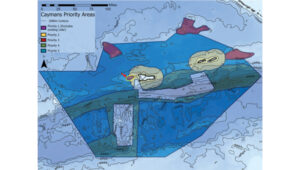
The waters of the Cayman Islands are abundant in marine life, featuring coral reefs, seagrass beds and a variety of fish species. A high-resolution map of the seafloor is essential to begin exploring, identifying, characterizing, exploiting, conserving and managing ocean resources. Saildrone has begun a mission to map 29,300 square nautical miles (100,490 sq km) of the Cayman Islands’ Exclusive Economic Zone (EEZ). This mission uses autonomous technology to survey 80% of this EEZ.
The Cayman Islands EEZ, extending up to 200 nautical miles from shore, encompasses an area nearly half the size of Florida — and 380 times greater than the island itself. The mission will provide detailed and precise bathymetric data for this area, contributing to a comprehensive understanding of the seafloor topography in the region. The data collected seeks to enhance maritime navigation and support scientific research, environmental conservation efforts and marine resource management in the Cayman Islands.
“Our waters hold such great value to us for a myriad of reasons, ranging from recreational to economic. Conducting this assessment will allow our government to make data-driven decisions that will strengthen our policies and legislation as it relates to our maritime infrastructure,” said Juliana O’Connor-Connolly, premier and minister for District Administration and Lands.
The Saildrone Surveyor USV is a purpose-built platform for autonomous deep-water ocean mapping. (Photo: Saildrone)
The mission is philanthropically funded by the London and Amsterdam Trust Company Limited, a Cayman-based organization. Saildrone is tasked with collecting the raw bathymetry data, which will be provided to the UK Hydrographic Office to process and update the Cayman Islands’ nautical charts. The data will belong to the government of the Cayman Islands.
Autonomous seafloor exploration
The mission is being conducted using a 20-m Saildrone Surveyor uncrewed surface vehicle (USV) equipped with MBES and metocean sensors for ocean mapping and ecosystem monitoring, as well as radar, cameras and advanced machine learning. Metocean stands for meteorology and physical oceanography. Globally, only 26% of the ocean has been mapped, a result of the lack of survey ship capacity. While a survey ship takes years to build, Saildrone can produce one Surveyor in as little as six weeks.
This nautical chart shows the Cayman priority mapping areas. The yellow oval indicates the vessel’s location as of Dec. 9, 2024. (Photo: Saildrone)
Saildrone USVs have demonstrated a reduction of more than 97% in operational carbon emissions when compared to survey ships to accomplish the same task. Additionally, they lower the risk to personnel. This information is highlighted in Saildrone’s Carbon Impact Report, which provides a comprehensive evaluation of the carbon emissions associated with maritime data collection and the emissions mitigated by using Saildrone’s USVs.
Saildrone’s ocean mapping solutions support storm surge modeling efforts and emergency response, as well as coastal resiliency and hazard studies, resource management, restoration projects, habitat mapping and infrastructure for renewable energy generation. USVs equipped with deep ocean mapping sonars now serve as a reliable option for data collection in large areas such as EEZs.
Bathymetry is crucial to understanding Earth’s aquatic environments. Its importance has evolved significantly since the early days of navigation, when mariners relied on lead lines and poles to gauge water depths. The field of bathymetry continues to advance with emerging trends that enhance data collection capabilities. Autonomous platforms such as USVs and autonomous underwater vehicles are increasingly utilized for bathymetric surveys, allowing for more extensive and detailed mapping. Additionally, as the industry grapples with challenges such as workforce shortages and the need for more efficient data collection methods, autonomous systems are proving to be a valuable solution.
Trimble’s Applanix POSPac MMS, an advanced GNSS-inertial post-processing software, seamlessly integrates with the Applanix POS MV and multibeam or sonar sensors to deliver high-accuracy results. (Photo: Trimble)
“Autonomous and uncrewed platforms have become a real force multiplier, and the trend continues,” said Peter Stewart, director of marine products at Trimble Applanix. “Companies such as XOcean and Saildrone are showing what is possible, leveraging cloud processing and enabling data collection in remote areas while maintaining a work-life balance for their staff. Since finding qualified engineers and surveyors to fill these roles offshore is an industry-wide concern, more flexible working conditions are needed to hire and retain talent.”
Another emerging trend is the development of sensors capable of penetrating murky waters, which can significantly enhance surveyors’ ability to gather data in challenging environments. Advanced sonar systems, innovative light-and-sound combinations and newly developed sensors allow research teams to collect detailed data. Post-processing technology for bathymetry has also significantly advanced, making data acquisition, processing and presentation more efficient and accessible. This allows researchers to map and study underwater terrains that were previously inaccessible or poorly understood.
Typical marine vessel data processed in POSPac MMS PP-RTX mode. (Photo: Trimble)
“Ease of use and installation are key trends toward ensuring valuable hydrographic data can be acquired, processed and presented efficiently,” Stewart said. Trimble works with users and third parties to offer an optimal workflow, making technology and the data it creates more accessible and operations more efficient, he added.
The IN-Fusion+ PP-RTX2 processing mode in Trimble’s POSPac MMS software is designed to improve post-processed GNSS-inertial trajectory generation. This mode uses Trimble’s CenterPoint RTX technology to deliver centimeter-level positioning accuracy without the need for local base stations. Stewart shared how this technology can be particularly useful when surveying around offshore windfarms, where shore-based RTK infrastructure is often too distant to be useable.