CSR plc and OriginGPS have announced a series of high- performance GNSS modules using CSR’s SiRFstarIV and SiRFstarV product lines.
The new modules are 70% smaller than current solutions and deliver a 30% reduction in Time To First Fix (TTFF), making them ideal for health and fitness trackers, sports watches, medical devices, wearable action cameras, and digital still cameras. All modules, including the newly released 7 x 7 millimeter Multi Spider (ORG4572) solution, integrate the LNA, SAW filter, TCXO, RTC crystal and RF shield.
“To accelerate market adoption of location technologies in wearable devices and cameras, manufacturers must minimize the embedded GNSS module size without compromising on performance, sensitivity, or power consumption,” said Anthony Murray, senior VP, Business Group at CSR. “By leveraging CSR’s industry-leading GNSS solutions and collaborating with OriginGPS on module development, we have achieved this objective.”
The OriginGPS modules offer high sensitivity resulting in shorter autonomous and aided TTFF, better navigation stability, and higher accuracy in harsh environmental conditions. In real-life testing of the module in camera applications, TTFF performance improves by over 30 percent compared to other solutions. The module also delivers TTFF results in less than one minute over 90% of the time (cold starts).
In addition to its small footprint, the GNSS module’s ultra-fast geotagging capability dramatically improves the consumer experience. The GNSS antenna module’s outstanding sensitivity and OriginGPS’ proprietary Noise Free Zone (NFZ) technology for faster position fix and navigation stability provides geo-tagging availability even under challenging satellite signal conditions such as low signal areas, under dense foliage, in urban canyons, and during motion-based activities. Battery life is considerably extended as a result of CSR’s breakthrough low power Push-to-Fix (PtF) technology, which rapidly establishes a valid position fix enabling the module to hibernate for longer periods of time. Push-to-Fix is an intelligent periodic low power mode that adaptively changes power depending on the operating environment and motion conditions. Advanced algorithms and a powerful on-chip DSP processor maintain high accuracy (QoS) while achieving the lowest power level possible for the given environmental and motion conditions.
“As the wearable technology and action camera markets continue to grow, we must ensure that our solution meets the market’s need for high performance and small form factor GNSS modules,” says Gal Jacobi, CEO of OriginGPS. “It is our privilege to partner with CSR and its excellent engineering team to meet the market’s need. CSR’s leading multifunction semiconductor platforms and OriginGPS’ miniaturized high performance modules create a unique value proposition for customers in these markets.”
OriginGPS modules are currently in mass production, and additional information can be found at www.origingps.com.
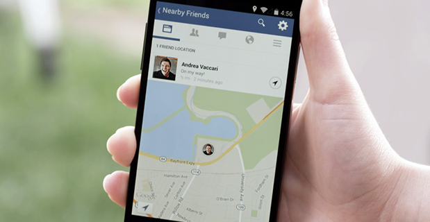
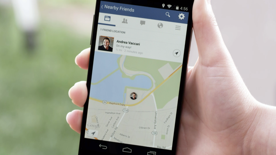
Facebook Nearby Friends feature helps people get together.
While Facebook has made big news buying companies for billions of dollars, it hasn’t been making many location-based services headlines. The recent announcement that it is rolling out a friend finder is interesting news, not only for social applications, but the potential indoor positioning markets. The news is also interesting because as many as half of Facebook users access the social media network through mobile devices.
Signaling that it does have a location strategy, as GPS World reported earlier this week, Facebook announced that it was launching an LBS offering called Nearby Friends. The opt-in service allows users to find out what friends are nearby or mobile.
Nearby Friends will be available on Android and iPhones in the U.S. market this month. In Facebook’s press announcement, apparently privacy is a big issue as the company insists it is an opt-in function.
Once users agree to use the service, they will be notified when friends are in close proximity. Users can select the friends who can see their location — and can turn the service on or off at any time.
At first glance, Nearby Friends could be a valuable tool for users looking to find friends and make plans, but the real potential could be for retailers who wish to drive in-store traffic. Users can not only invite friends to a specific business on a map, but tag other traffic.
The area or business to where the friends are traveling will be displayed on their profile. This allows the friends who opt in to recommend shops, restaurants and other things to do in the specified area.
How retailers get their message out to Nearby Friends users remains to be seen. Research company Berg Insight still says advertising will constitute the main revenues for social networking and local search market segments. However, in several published reports, users have tired of the increased Facebook advertisements.
Berg says that social networking and entertainment has now overtaken mapping and navigation as the largest location market. The company says that those services include general social networking, messaging apps, friend finders such as Nearby Friends, and games.
While Facebook could use the Location History in Nearby Friends to make money selling ads, the company says it isn’t right now. But it has to be the future — and one that, privacy issues aside, could be very lucrative for the company. It could target opt-in users with ads that are only a few feet away or in the area they will meet friends.
The Wall Street Journal reported that Facebook will leverage its user base, estimated at one billion users, to improve ad targeting, expand marketing reach, and to make more money. The company earned $1.24 billion in revenue through mobile ads for the last three months of 2013, according to published reports.
After the announcement that Facebook was launching Nearby Friends, a number of tech business articles sprung up about potential, real and imagined, privacy issues. With the predictable privacy issues comes opportunities for location startups. A new location app is touting itself as the “anti-social networking” tool. Called Cloak, and available in Apple’s App Store, it allows a user to avoid friends they want to avoid by revealing the location of contacts — while keeping the user’s position hidden.
The app, which already has been downloaded more than 100,000 times, uses Instagram and Foursquare data, and published reports say Facebook compatibility is coming soon.
Rumors about Acquisition Prove False?
Earlier this month, several tech business industry publications wrote that Israel-based indoor navigation startup ShopCloud was in talks with Samsung to sell the company for as much as $90 million. Samsung has denied the rumors.
In articles like these, red flags always include terms like “several sources familiar with the details”. The price seemed high for a young company that hasn’t launched a product, though according to published reports, it has an app called Inside.
One analyst says that the Israel tech business media frequently pumps up local companies and even creates buzz for startups — and often these reports are picked up by local journalists.
Autonomous Vehicles Will Happen, but When?
In January’s Transportation Research Board (TRB) meeting in Washington, D.C., attendees agreed that self-driving vehicles are the future. The bottom line is when is the future? “We have seen the business case for autonomous vehicles — it will be a reality. When you look at the number of lives it will save, efficiency of the network, it is very compelling,” said Kevin Link, Verizon senior vice president and general manager, China. “We have to begin a slow migration of educating consumers — one of those ways is through the connected vehicle. I don’t think consumers are there yet.”
Link talked about autonomous vehicles at the Consumer Telematics Conference, also in January, but those at TRB are mainly academics and government officials, not business executives. Most believe it will take decades, Google car aside, to have a fully autonomous vehicle on the road. Others believe that if Detroit does not take notice, they can read about Google dominating this vehicle market, not being a player in it.
In other location news:
Place, the Business of Location conference will be July 22 in New York. Executives from SK Telecom, Thinknear, Sonic Notify, Aisle411, and Factual will join Google, retailer Alex and Ani, and agency MEC North America (WPP), among others. The conference will include case studies and explore how mobile, offline tracking and indoor location will change the future of digital marketing and brand advertising. Many location conferences have died in the last two years, so it is refreshing to see a conference with a strong agenda back on the scene.
Finland-based IndoorAtlas rolled out an indoor mapping application for iOS. While iOS supports Apple’s iBeacon micro-fencing solution for indoor positioning, IndoorAtlas uses the compass chip built into smartphones and does not require external hardware such as Bluetooth beacons or Wi-Fi to determine location, the company said.
The U.S. Patent and Trademark Office awarded Apple a patent that could drive technology on the next generation iPhones. The patent describes a system that combines GPS, Wi-Fi access points, and on-board location databases to provide mobile devices positioning data in all types of environments, particularly indoor location.
Concerns about data privacy aren’t going away and, in fact, are growing. Many retailers that have adopted in-store tracking technology to enhance shopping experiences and gather information on customer behavior have met with backlash. Increasingly, people are turning to a new crop of apps to safeguard how personal information is used in other apps. We have apps to guard other apps. The world is getting more confused and scary. The Heartbleed bug and other threats have heightened concern about an even more threatening vulnerability of our connected world. So how will drivers feel about increasingly automated vehicles that generate huge masses of data of an exceedingly personal nature? What happens when it is hacked?
Automated vehicles require multiple types of sensors to obtain information about the vehicle, its movement, and the surrounding environment, which includes the roadway, other vehicles, obstacles and infrastructure. All sorts of ambient information may be captured. Perhaps activity outside of your house, or your kids on their way to school, or the licenses of cars in your driveway will be caught on camera.
The massive amount of data collected needs to be crunched, and only some of it will be processed within the vehicle. Other captured data will be sent off-board to the cloud for handling, with results then returned to the vehicle. The amount of data that will be created by automated vehicles is uncertain, but I’ve seen estimates of 1 GB per second. Whatever it is, it will be immense.
What’s collecting data in a driverless vehicle? Lidar, a laser technology that uses reflected light, is identifying everything around the vehicle with great precision. Cameras are taking pictures to detect phases of traffic lights, identify stop signs, and map road lane markings. GPS is tracking the location of the vehicles and helping with navigation. Sonar is detecting objects and measuring their distance, speed and direction. And each vehicle is exchanging positioning, braking, heading and speed data with other vehicles on the road to prevent collisions.
The data generated is both of a critical and personal nature. And data that is moving in and out of the vehicle to be processed elsewhere or to communicate with other vehicles is particularly vulnerable. The consequences are far greater than a violation of privacy or a stolen identity. The operation of vehicles is at risk to be maliciously disrupted to disastrous outcome. This isn’t an issue we can put off until driverless vehicles are closer in reach. Vehicles today are increasingly equipped with safety and entertainment features that capture critical or sensitive data, any of which could present a threat in the wrong hands.
Facebook Nearby Friends feature helps people get together.
Facebook has started rolling out a feature called Nearby Friends. Users can turn on the feature to help them discover which friends are nearby or on the go. When notified that a friend is nearby, the user can then get in touch or meet up.
“For example, when you’re headed to the movies, Nearby Friends will let you know if friends are nearby so you can see the movie together or meet up afterward,” wrote Andrea Vaccari, Facebook Product Manager, in an article on the website.
Nearby Friends is an optional feature. Users can choose who can see whether they are nearby (such as friends, close friends, or a specific friends list) and it can turned on and off at any time. Both the user and the friend needs to have the feature turned on and choose to share that information before notifications are sent.
Users can also choose to share a precise location with particular friends for a set period of time, such as the next hour. The friend will see exactly the user’s location on a map, to help them meet up.
Nearby Friends will be available on Android and iPhone in the U.S. over the coming weeks.
Researchers at Telecom SudParis are working on a solution to provide indoor continuity for GNSS positioning. The idea is to deploy a minimal transmission infrastructure in order to allow a standard receiver to measure pseudo-ranges and carrier phases, thus leading to an indoor accurate positioning. The infrastructure consists of a few antennas fed through optical fibers with a GNSS-like signal.
Based in Paris, Telecom SudParis is a part of the Institut Mines-Telecom, an education and research institution in the fields of information and communication technology.
Nel Samama
To achieve positions accurate to a few decimeters, the locations of the various indoor antennas had to be accurately known. This was achieved with the Spectra Precision FOCUS 8 total station in a local reference frame. In addition, in order to calculate the indoor positioning in WGS84 format, to achieve full compatibility with current outdoor GPS, a Spectra Precision ProMark 800 GNSS receiver was used to link the local reference frame and the GPS. “ The accuracies of the FOCUS 8 and the ProMark 800 and their ease of use were invaluable to us,” said Nel Samama, lead researcher and Professor at the Institut Mines-Telecom.
The International Conference on Indoor Positioning and Indoor Navigation (IPIN) 2012 and 2013 published the first results of the research, and the latest results will soon be published in a paper, “Repealite Based Indoor Positioning System Performance.” The papers propose a new approach to indoor positioning: the repealite system. It aims at providing continuity of the positioning service through the use of GNSS-like signals, thus leading to a single technological means: a GNSS receiver, for both outdoors and indoors. A few error sources have been dealt with in order to reach sub-meter accuracy indoors, among which one has to cite multipath and near-far effects. The paper describes a way to reach indoor sub-meter accuracy and the practical current implementation of the system.
A newly issued report by MarketsandMarkets focuses on growth in the location-based services market, and says it will be worth $39.87 billion by 2019.
The report, “Location Based Services (LBS) Market (Mapping, Discovery and Infotainment, Location Analytics, Leisure and Social Networking, Location Based Advertising, Augmented Reality and Gaming, Tracking) — Worldwide Forecasts and Analysis (2014-2019),” provides a comprehensive market and forecast analysis of the overall market, segmented by products, services, technologies, applications, regions, and verticals. The report covers all the major sub segments of the LBS market and provides the quantitative (market size and market growth) and qualitative (trends, analysis, and insights) analysis for those segments.
Included are 99 market data tables, 17 figures spread through 254 pages, and an in-depth table of contents on the LBS market. This comprehensive coverage of the LBS Market provides important inputs such as drivers, restraints, and opportunities in this market, profiles the major players in this market, maps the competitive landscape, and provides the overall perspective on the LBS Market in the various verticals and regions, according to MarketsandMarkets.
LBS is a solution that stands for applications that integrate geographic locations information with business processes, helping in analysis of location information. The location-based information is required in distinct business data sets for relating, comparing, and analyzing relationships in the data. The service also provides an economical alternative to agencies with existing internal GIS resources. As a result of these multidimensional benefits of location information, operators are considering it as an asset, leading to numerous investments being made to extract, use and market it.
SkyTraq‘s new family of high-performance system-in-package (SiP) GNSS receiver modules supports GPS, GLONASS, Beidou, QZSS and SBAS.The modules integrate SkyTraq Venus8 positioning engine, 1MByte Flash memory, LNA, SAW filter, high precision 0.5ppm TCXO, RTC crystal, and other passive components within tiny 10mm x 10mm x 1.3mm package. The smallest configuration requires only antenna and power to have position fix and generate NMEA output.
This new 10mm x 10m sized GNSS module family consists of Venus858F-GL GPS/GLONASS receiver module, Venus858F-BD GPS/Beidou receiver module, and Venus838F GPS receiver module. All three modules support additional QZSS and SBAS signal. The three modules are pin compatible; one application design works for all three models.
Within the consumer and industrial GNSS segment, these modules feature industry’s fastest 50Hz GPS, 20Hz GPS/Beidou, and 20Hz GPS/GLONASS update rate, 29sec cold start TTFF, and better than -160dBm tracking sensitivity.
Module interface includes two UART, four SPI, one 2-wire interface (I2C compliant), and two PWM among the 28 function-multiplexed digital I/O. A customized Arduino IDE can be used to program the modules, making use of the on-chip peripherals and sharing the internal 32bit RISC, IEEE-754 compliant FPU, and memory resources. Venus838F GPS module has roughly 50MIPS + 490KByte Flash + 45KByte RAM available for user programming.
Optimized for lowest bill of material cost, the dime-sized modules are designed for high-volume cost-sensitive GNSS applications. Combined with properly tuned antenna fitted to customer’s application design, it provides optimal performance at lowest system cost.
To lower barrier of adopting latest satellite navigation technology, the traditionally higher-priced GPS/GLONASS and GPS/Beidou receiver modules are offered at same price as the GPS receiver module.
Volume delivery of all three modules to customers begins in May 2014; engineering sample, datasheet, reference design, and evaluation kits are available now.
Broadcom Corporation has announced the industry’s first 5G Wi-Fi (802.11ac) system-on-chip (SoC) to deliver pinpoint indoor positioning technology. The BCM43462 SoC, featuring Broadcom’s new AccuLocate technology, provides sub-meter accuracy on physical locations enabling retailers and public venue operators to deliver more personalized experiences to consumers.
Analysts predict the indoor location market to reach $4 billion in 2018, fueled by increasing demand for location-based services in public venues such as shopping malls, department stores, airports and stadiums. By leveraging location-based services, retailers and venue operators can offer discounts, promotions and personalized services to consumers based on exact locations while enterprise network IT staff can use the technology to track and manage assets, Broadcom said.
Broadcom’s latest 5G Wi-Fi SoC with on-chip AccuLocate technology operates using fine timing measurement (FTM) technology, resulting in highly accurate positioning regardless of environmental factors, Broadcom said. Previous versions of indoor positioning relied on received signal strength indicator (RSSI) technology, where signal strength and performance can vary depending on environmental factors such as crowd density or temperature.
“Broadcom’s latest 5G Wi-Fi innovation with integrated AccuLocate technology delivers highly accurate sub-meter pinpoint technology that rivals the capabilities of outdoor location based technology,” said Ed Redmond, Broadcom vice president and general manager, Compute and Connectivity. “In addition to providing a more customized user experience, this technology has the added benefit of allowing venue operators to monetize their investment in existing Wi-Fi infrastructure.”
“Location-based technology installations will break the 25,000 mark in 2014, while mobile devices capable of supporting indoor location will reach hundreds of millions within two years,” said Patrick Connolly, ABI Research senior analyst. “Rising demand for these services by the world’s leading venue operators and retailers is generating an immense opportunity for leading component suppliers, such as Broadcom, who are early to market with innovative solutions.”
About 5G Wi-Fi
Increased reliance on wireless networks, the explosion of video consumption and growing number of wireless devices are all putting tremendous stress on legacy 802.11a/b/g/n networks. With new innovations that allow for more reliable coverage, 5G Wi-Fi technology addresses these challenges, allowing mobile device users to stream digital content between devices faster, and simultaneously connect more wireless devices to home and enterprise networks, while conserving battery power.
Key Features of the Broadcom BCM43462 SoC
Dual-band (2.4 GHz and 5 GHz) complete 5G WiFi (11ac) SoC with integrated MAC, PHY and radio
Three-stream spatial multiplexing up to 1.3 Gbps
State-of-the-art security provided by industry standardized system support
Embedded hardware acceleration enables increased system performance
Full IEEE 802.11a/b/g/n legacy compatibility with enhanced performance
Support for FASTPATH® UAP, Broadcom’s enterprise class access point software
Availability
Broadcom’s BCM43462 SoC with integrated AccuLocate technology is now sampling. AccuLocate technology is also available on Broadcom’s BCM43520 5G Wi-Fi 2X2 SoC, BCM43460 5G Wi-Fi 3X3 SoC and BCM4354 5G Wi-Fi 2×2 MIMO Combo Chip.
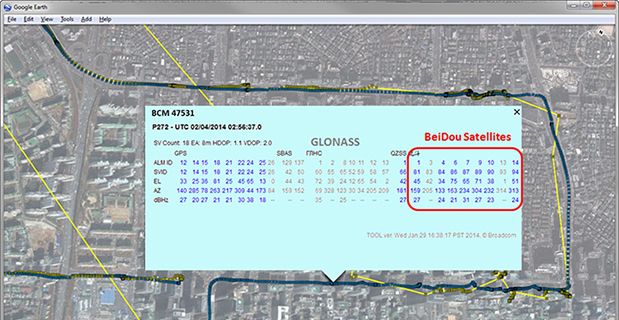
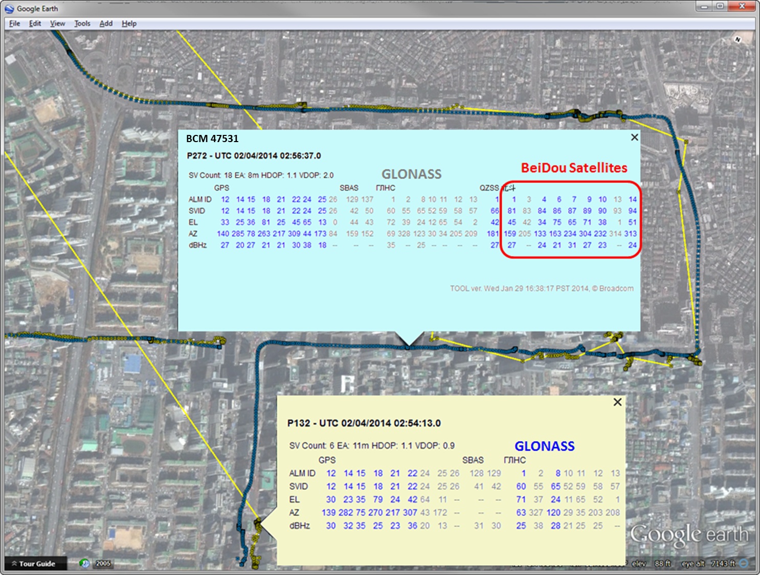
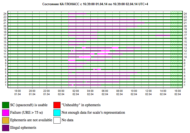
Yesterday we posted news of an 11-hour downtime for the full GLONASS constellation, due to an upload of bad ephemerides. Coincidentally, during that 11-hour period, the mass-market chip company Broadcom was conducting multi-constellation receiver tests in Asia. Frank van Diggelen, Broadcom’s chief GNSS scientist and vice president says, “We have definitive data to show how a multi-constellation receiver survives such an outage.”
Here are the pictures, and the story they tell.
Test data coincident with the GLONASS ephemeris disruption of April 1 and 2 showing conclusively how a GPS/GLONASS/QZSS/BEIDOU receiver survives the complete disruption of one of the constellations.
On April 2 at 1:00 a.m. Moscow time, bad ephemeris was uploaded to all satellites (see chart at the bottom of this story).
There are two receivers shown here, from two different manufacturers, both in smartphones. The yellow dots are for a GPS/GLONASS receiver; the blue dots are from the Broadcom 47531 receiver which tracks GPS/GLONASS/QZSS/BeiDou signals simultaneously. The 47531 receiver includes logic to use redundant measurements to check the validity of all measurements. It successfully identified and removed the bad GLONASS ephemeris 100 percent of the time, as can be seen by the continuity and accuracy of the positions.
Here is the satellite outage chart from yesterday’s story. All GLONASS satellites were restored to healthy state after the 11-hour interruption.
Current plot from the Roscosmos GLONASS Information-Analytical Centre. Things are almost back to normal this morning.
Swedish WTS (Wonder Technology Solutions) and u-blox have announced that WTS has launched Trax, a personal tracking device for children and pets. Based on u-blox’ GNSS smart antenna and cellular module, the tiny tracker can be located anywhere, anytime via a free Android or iPhone mobile phone app.
In addition to real time tracking, Trax provides flexible geofence alerts, and can even monitor how fast your teenager is driving. It also works indoors thanks to a proprietary dead reckoning algorithm that delivers a position even when satellites are out of sight. Accurate down to 1.5 meters, the robust, water-resistant device also provides an “augmented reality” mode that helps users locate their trackers using a Smartphone’s built-in camera view.
To achieve the smallest possible size, Trax takes advantage of u-blox’ CAM-M8Q GNSS receiver module, which has a built-in antenna. CAM-M8Q (chip antenna module) provides both small size (9.6 x 14.0 x 1.95 mm) and multi-GNSS capability. It is based on a u-blox M8 chip and incorporates a chip antenna, SAW filter, LNA, TCXO and RTC crystal. The surface-mount module is also extremely low in height, making thin customer designs possible.
“Trax is the world’s smallest and most versatile personal tracking device available, packed with features designed to provide peace of mind to parents and pet owners almost anywhere in the world,” said Fredrik Danelius, managing director at WTS. “By combining the leading GNSS and cellular technologies from u‑blox, we have designed a tiny, reliable, low-cost device that protects our most valuable family members: children and pets.”
Trax comes with an integrated SIM-card and two years of free data and roaming in 33 countries. It is charged via USB and typically lasts between two and four days on a full battery. For wireless connectivity, the device contains u‑blox’ SARA-G3 GSM/GPRS module which is footprint compatible with u-blox’ 3G SARA-U2 module for easy 2G to 3G upgrade.
“Trax is an elegant and sophisticated example of our embedded GNSS and cellular modules combined to protect people’s loved ones”, said Pasi Alajoki, area sales manager at u-blox. “It is an important application of our mobile communications and global positioning technology where performance, size and power consumption play a critical role. We are proud WTS chose u-blox for Trax.”
As the tragedy of Malaysia Airlines Flight 370 riveted our attention, many sprang into action. More than two million volunteers scoured online satellite images for signs of the plane via Tomnod, a crowdsourcing project of DigitalGlobe.
Volunteers like Robert Wilkinson are asked to view satellite photos and tag any signs of wreckage, rafts, oil spills and other objects that may be of interest. “It took me the first hour to understand that I was looking at waves or tidal pools rather than debris or anything useful to the search,” said Wilkinson. “After that, I might have seen one or two things that I couldn’t explain, but I tagged them appropriately.”
All images that are tagged are reviewed by special algorithms before being viewed by experts. Tomnod reported that more than 650,000 objects had been tagged, and the maps had been viewed more than 98 million times.
Calls on Flight 370. This month, the Internet was full of questions about mobile communications and the missing Malaysia airplane. People didn’t understand why passengers on board the flight hadn’t made mobile emergency calls. On September 11, 2001, it was widely recalled, some passengers were able to make phone calls from the hijacked planes. Flight 370 was likely too high or going too fast to enable phones to register with cell towers. Experts say that planes flying above 5-10,000 feet would have difficulty making connections. Radar analysis estimated that the plane may have been flying as low as 12,000 feet or as high as 45,000 feet. On 9/11, passengers made calls when the plane was low or used satellite air phones available in business class.
GPS and Football. Security at places where large crowds congregate is always a concern. At last month’s Super Bowl, GPS devices tracked and monitored the team vehicles. To protect the GPS, a product from Exelis was used to detect and locate GPS interference sources to protect critical GPS signal-dependent infrastructure. Eight sensors were positioned in an array pattern to detect and locate any jamming sources.
Lost in Space. Google’s Project Tango is showcasing a prototype phone brimming with software and sensors that creates a 3D map of the environment. A select group of developers has been given the device and are expected to create innovative applications, including navigation by sight. We do know that one of these devices will be heading to the International Space Station and will be part of a project to enable robots to explore the inside and outside of the craft. The terrestrial uses of the device will include being able to map the interior of a house (the sofa goes where?), navigate through complicated buildings, provide accessibility for those with impaired vision, and emergency response. Project Tango may find interesting uses with 3D printing, which is riding a wave of interest.
GPS and LED Lights. Philips has been demonstrating an indoor location-based shopping service based on location positioning from LED lighting infrastructure. The system works by using lighting fixtures that form a dense network that not only provides light, but also acts as a positioning grid. Each fixture is identifiable and able to communicate its position to an app on a shopper’s smart device. ByteLight is another company with LED indoor location technology. Wi-Fi and Bluetooth low-energy (BLE) beacons are more established for indoor positioning.
Truck Market on the Move. Market demand remains strong for mobile resource management (MRM) devices, particularly among local fleets, reports C.J. Driscoll & Associates. “Manufacturers of light and heavy commercial vehicles are becoming increasing involved with telematics,” says Clem Driscoll. “Heavy truck manufacturers are primarily focused on enabling remote vehicle diagnostics.” Many of the large MRM companies are establishing added offices around the world.
Awkward Timing. INRIX is launching Russia’s first comprehensive traffic information and driver services platform. Russia has many challenges including difficult traffic conditions. The service, available on Audi cars, was developed through an exclusive partnership with Russia’s navigation services provider cdcom. INRIX XD Traffic in Russia provides real-time traffic and incident information covering more than 236,000 kilometers of roadways across 55 cities.
When one talks about the worldwide location industry, mobile resource management — fleets and trucks, for instance — aren’t sexy at all, but they make money. What is supposed to be sexy is location-based advertising. According to many analysts, location-based advertising has been hampered by a few things: education for both consumers and mobile advertisers, privacy issues, and relevant proximity information so folks can use it to make purchases. Another concern could be the expense of rolling out indoor beacons.
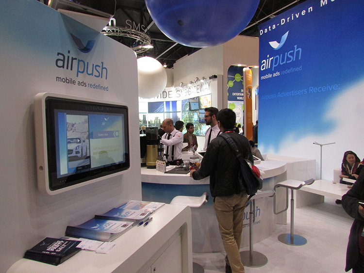
BARCELONA—Major consumer privacy concerns aside, companies are starting to see growth in location-based advertising, with new markets emerging in Europe. While the numbers of mobile advertising companies has decreased at the Mobile World Congress, held here in February, from just two years ago, the remaining players are seeing a more mature market.
Mobile advertisers are beginning to realize that location is the Holy Grail for growth, said Cameron Peeples, Airpush vice president of marketing. “People going into New York from Newark during rush hour can receive a different call to action because of a created geo-fence. Advertisers can determine whether the traveler is there on business or looking for a hotel and other travel deals,” he said.
Before Mobile World Congress, Los Angeles-based Airpush partnered with AirX, a large mobile ad exchange company. The majority of the AirX inventory, about 120,000 Android applications, includes highly-sought-after GPS location data, the company said.
There are large differences between the North American and European markets for mobile advertising, Peeples said. “The mobile advertising market [in Europe] is definitely evolving. The European market is key for us, dramatically higher than other markets,” he said. “[The European] market seems to have people connected to a lot of things — they are more mobile, use public transportation more, and always have a phone that is more centric to who they are.”
Making location-based advertising relevant to the consumer is still a major challenge. “Our focus next year is on native advertising. Native advertising combines not only the right message, but the right delivery vehicle,” Peeples said. “No one bicycling enthusiast wants ads tailored for someone who wants flowers.”
Peeples said the privacy issues are a big deal, but his company’s services are opt-in. “A lot of it is loyalty advertising. It’s all opt-in,” he said.
xAd Partners with Waze, Sees UK Growth
Another mobile advertising company, New York-based xAd, is also making inroads in Europe. “We are in the UK right now, which is really WiFi-focused. A lot of our early [location-based] advertising efforts are in education — to educate consumers and the advertising agencies about the power of location and mobile,” said Monica Ho, xAd vice president of marketing. “Not all location is created equal. The real value of [location-based advertising] is the proximity target to market to.”
Right before Mobile World Congress, Waze selected xAd as its third-party provider of search and display mobile ads in the United States. Waze, which was bought by Google in a deal worth more than $1 billion, is a top three map and navigation app in the iTunes store — a ranking that was probably helped by the Apple Maps debacle in 2012.
The companies say the deal will place xAd’s mobile ad targeting technologies into Waze’s location-based advertising platform.
Ho said there are still two areas of concern for location-based advertising: relevancy to the consumer and privacy issues. “There was privacy backlash from Nordstrom collecting consumer information from their Wi-Fi system,” she said, referring to the controversy last year when the retailer was accused of capturing consumer information during an indoor positioning test.
Apple to Roll out Upgraded Maps on iPhone 6
Speaking about Apple Maps, many industry analysts says the company has come a long way since the very public embarrassment nearly two years ago over map inaccuracies and flaws. The company recently released iOS 7.1, but is expected to rollout iOS 8 when the iPhone 6 debuts later this year.
With the debut of the iPhone 6, an updated version of Apple Maps will also be released, according to published reports.
Last year, Apple bought two companies, HopStop and Locationary, to allow the company to entrench itself once more in the location business. How firmly those roots prove to be, and how well they serve the company against archrival Google, remain to be seen.
Apple has been stockpiling companies and mapping software since its introduction of Apple Maps on iOS devices, which had a rough start. GPS World’s LBS Insiderreported extensively on the problems Apple encountered with its mapping software. Some of these problems included sending drivers to a wrong location and direction.
After the mapping software problems were made public, Apple CEO Tim Cook apologized for the mapping software’s problems and even suggested that users go to such competitors as Waze, MapQuest, and Microsoft’s Bing.
In other location news:
A Wall Street Journal reporter basically said there was nothing much new at Mobile World Congress — and that the excitement and action was at the outlying conferences at Fira Montjuic. One of these more interesting conferences, Four Years From Now, or 4YFN, featured start-up companies making pitches and displaying their new products, some of which included location capability.
The Mobile World Congress final stats. Organizers said MWC had more than 85,000 attendees from 200 countries — an increase of 13,000 from the previous year. It’s now being touted as the biggest and best wireless show.
In February, GPS World reported that TruePosition had purchased Skyhook for an undisclosed price. Skyhook provided location services to a number of companies including Apple and Samsung. The interesting issue is Skyhook’s lawsuit with Google, which alleged that the Internet giant influenced smartphone manufacturers to abandon the Boston-based company. According to published reports, the legal action still is going forward.
AT&T Mobility is shuttering its location-based Alerts marketing program. The company said it would release an updated version later this year. AT&T Mobility launched Alerts in late 2012. It featured free opt-in, location-based text message alert service. Participating retailers included Stapes, Gap, Zales, Neiman Marcus, and others.
I didn’t go to South by Southwest. Is my cool-guy card revoked? One of the reasons I didn’t is because, outside of meetings that were not part of the conference, there was not one location industry announcement made there. Maybe something will change my mind next year, but call me an old fogey — I just didn’t see the need to go to Austin this year.