Q: What is the “killer app” for professional use of drones? What UAV market sector will most powerfully drive adoption and influence new regulations?
Jan Leyssens Product Manager, SeptentrioA: The mapping market is opening up. On construction and mining sites, surveyors walk between dozers and dump trucks to create digital terrain models, a time-consuming and dangerous job, which drones can do more efficiently and safely. These jobs are performed in non-public areas, without significant risks or privacy concerns, facilitating public acceptance. Subsequently the potentially larger inspection market will open up. Drones provide an easy, safe way to inspect wind turbines or other installations that are difficult or dangerous to reach.
Tony Murfin Contributing Editor, Professional OEM & UAV, GPS WorldA: The agriculture industry seeks even greater Improvements in crop yields. GNSS systems in the cabs of combines/harvesters have already helped significantly, but drone use for crop-growth monitoring, data collection and pesticide-prescription application is the big breakthrough — once rules for large-scale low-level drone flight over farmland are approved. Ag will push for published rules just as hard as the movies, real-estate and all types of aerial survey for construction and utilities.
Eric Gakstatter Contributing Editor, GIS & UAV, Geospatial SolutionsA: Amateur photographers and hobbyists are where the volume is. The world’s largest UAV manufacturer now exceeds $1B annual revenue. Its growth is being driven by the hobby market. Commercial use of UAVs is a very small piece of the worldwide UAV market. The UAV market will be very similar to the GPS receiver market, just not at the same scale. The volume in the UAV consumer market will drive the technology (sensors, motors, software) that will benefit commercial UAV manufacturers.
Longing for the good old days when we mostly worried about nukes
Years ago, Navy colleague Commander Stephen Rose drew a lot of attention at the Naval War College with his essay entitled “The Coming Explosion of Silent Weapons.” The essay was awarded both the Colbert Memorial Award and the Joint Chiefs of Staff Writing Prize. I never thought that 27 years later his paper would seem so timely and highlight the critical need for the geospatial work being done by the NIH (National Institutes of Health), CDC (Centers for Disease Control), DTRA (Defense Threat Reduction Agency), U.S. Army and others.
In his paper, Commander Rose reviewed emerging warfare technologies including chemical warfare, biological warfare, gene splicing, nano technology, remotely piloted vehicles (RPVs) and more. He compared the complexity and expense of a country trying to develop a nuclear capability compared to the relative ease and low cost of developing chemical and biological weapons, which were sort of a “poor man’s nuke.”
Although, years later, the countries named in the paper have not changed significantly: Iran, Iraq, Syria and Libya. You can read the full paper at the Naval War College website.
Worrisome at the time, most of us took comfort in the built-in deterrence that was intrinsic with chemical and, more so, biological weapons. It was a genie that with a slight change of wind direction could hurt friendly troops as easily as enemy troops. Even more problematic, biological agents could affect not only friendly troops but even the user’s families in their own home towns. So for the past 27 years we’ve whistled past the graveyard in the belief that no one would be crazy enough to use biologics.
Although we were Cold War enemies, I knew that my Soviet counterparts shared most of my values. They enjoyed life, loved their families, relished their vodka and just wanted to go home and perhaps work on their Dachas. Even Star Trek Klingons were philosophically not that different from either of us. Enter the 21st century, and now suicide bombing has become a virtue with cash rewards paid to the surviving family members and a path to heavenly pleasures for the bomber. This, of course, changes everything.
Congressional testimony by National Intelligence Director Clapper and others have pointed to a growing concern about chemical and biological attacks. Additionally, some terrorists are not intellectual lightweights. Recently, the former Iraq chemical and biological expert Sleiman Daoud al Afari was captured, and this week the number two man in ISIS, former physics professor Haji Imam, was killed. So is it just a matter of time before someone with the right knowledge, skills and relatively light resources builds a biologic that gets out of control?
Esri Federal GIS Medical Special Interest Group
During the recent Esri Federal GIS Conference in D.C., I attended a session concerning GIS and global responses to pandemics and biological threats. The session was moderated by Dr. Este Geraghty, MD, MS, MPH, CPH, FACP, GISP, who is Esri’s chief medical officer.
Although the discussion focused mostly on the Zika virus, much of the background information covered the geospatial aspects of the Ebola outbreak in Africa. According to one of the presenters, David Foster, a U.S. contractor and prior Air Force veteran who participated in the response, the world response was quick, but it was also a dizzying collection of government and non-government agencies with more than 80 different responding groups. Somewhat disconcerting was that no one was really in charge and communications was poor.
Dr. Geraghty was kind enough to do a video interview, primarily focused on the concerns of this article and the need for a strong geospatial monitoring and analysis capability.
One example: Early GIS at CDC
In 199 when I retired from the Navy and became the GIS manager of the Atlanta Regional Commission, we established the region’s first Esri ArcView Learning Center. A number of CDC doctors and staff members took our ArcView II classes. Six months later, I was humbled with what those early students had accomplished. They used the relatively basic ArcView II to map disease outbreaks domestically and worldwide. The maps provided a valuable visualization tool that helped with understanding complex outbreaks and how to combat their spread.
The growing need for more sophisticated spatial monitoring, analysis and display led to the creation of GRASP (Geospatial Research, Analysis and Services Program). CDC and the Agency for Toxic Substances and Disease Registry, Division of Toxicology and Human Health Sciences (ATSDR/DTHHS) worked to build the needed geospatial capability, and in 2013 Booz Allen Hamilton was awarded a competitive contract to build a unified and comprehensive GIS support system for CDC and ATSDR.
GRASP program specifics include:
GIS analysis, research and geospatial statistics.
GIS remote sensing imagery analysis.
Cartographic design and production.
GIS web/desktop/mobile application design, development and maintenance.
GIS shared service design, development and maintenance.
GIS database design, development, management and maintenance.
GPS data-gathering, training and support.
GIS systems integration.
GIS training.
GIS project management.
GRASP has grown into a sophisticated monitoring and analysis system. When a serious outbreak occurs, CDC responds like other emergency response organizations and stands up an Emergency Operations Center (EOC) in accordance with the National Incident Management System (NIMS). GRASP maps, imagery and visualizations help everyone understand the nature and scope of the threat by creating a common operational picture.
This capability is further enhanced with new Esri tools such as Insight, easy geocoding, big-data deep analysis, tools for activating response teams, as well as sharing and collaboration with other federal agency and resources such as GEOINT, HUMINT (human intelligence), SIGINT (signals intelligence) and social media.
Natural or man-caused, and who makes the call?
Getting back to Commander Rose’s paper, one is left with the following points to ponder. Following a conventional or nuclear attack, a country instantly knows three things: that it’s been attacked, when it was attacked and where it was attacked. As a result, the subject country stands a good chance of figuring out who did the attack.
Conversely, with a biological attack, a country may not know when or where the attack occurred, or if it was even an attack and not just a natural outbreak. This then becomes a tough decision for our analysts, because announcing a devastating outbreak as a biological attack could be tantamount to announcing a modern-day Pearl Harbor without the benefit of seeing burning ships or falling buildings. Additionally, the path from analysis to a definitive determination and by who may not be completely clear.
Existential threat?
So, are we in a Cornelian dilemma? Are we better off pulling back and lying low in hopes that “they” won’t hate us enough to initiate a suicidal attack that launches Armageddon? Or do we act preemptively with all our intelligence and military resources to beat down any group that shows the slightest inclination and potential to entertain this suicidal activity?
Some politicians have stated that although we lost more than 3,000 people during 9/11, it was a relatively small percentage loss in the grand scheme of things; that the U.S. is so big and so powerful that we don’t face an “existential threat.” So one would have to ask if the loss of 10, 20 or 50 percent of our population would be existential enough?
Complicating the issue, as some of my intel colleagues are fond of pointing out, is that if some actions we are currently taking or not taking seem to make no sense, it’s probably because you don’t know all the facts.
Regardless, our monitoring and analysis capability may be one of the most important activities being done by our geospatial community. Additionally, we need to make sure that our protective agencies get what they need to do the monitoring and analysis to keep us safe. My hope is that we really are doing what needs to be done and not just dreaming of the good ol’ days when all we had to worry about was a nuclear attack.
In our redesign of the GPS World website, which coincided with our magazine redesign in November 2015, we endeavored to make the website even easier to use. Part of that effort consolidated some of our most popular features under the More dropdown menu. The little word appears at the far right of the menu row under our logo. Within it is a world of data and information to explore.
For those seeking current and historical data on the satellites in the various GNSS constellations, we have a full Almanac, which we update at least twice a year for the print magazine. If you want to stay on top of Upcoming GNSS Satellites Launches, we provide a handy table that is updated frequently by the one and only Richard Langley, our GNSS guru. Richard also oversees the numerous and informative Innovation columns, all of which are available under the Innovation tab — right there under More.
Our most current issue can be accessed through the words Digital Edition at the bottom of the page. Or, again under More, go to Magazine Archive for a full collection of every digital issue that reaches back a decade to 2005.
Other great resources under More are our annual Receiver Survey and Antenna Survey. Both of these products are time intensive to produce, pulling together data and specs from almost 100 companies in an effort to provide a full picture of the products available and their capabilities.
Similarly, the Buyers Guide link will take you to a special section on our website, allowing you to search manufacturers by product category and subcategory. Our next major update of the Buyers Guide will appear in print in June, but our gathering of the data now takes place year round as companies sign up to take part. If your company isn’t in our Buyers Guide, click on the “Add My Listing” link in the top right corner of the Buyers Guide page.
The unmanned aerial vehicle (UAVs) sector is a dynamic GNSS-enabled sector globally and Europe is no exception. In January I attended a UAV event at the Royal Military Academy in Brussels. The focus of the two-day meeting was on small commercial and recreational remotely piloted aircraft systems (RPAS) that are rapidly populating Europe’s airspace.
Currently, there is no European legislation that governs their use in conjunction with general aviation and, typically, national legislation varies across the member states. Regulators are trying to play catch-up.
One interesting EU project trying to tackle this situation is DroneRules.EU. Philippe Carous of SpaceTec Partners said the project’s main objective was to raise general awareness of the rules governing RPAS across the commercial sector and the general public. Speaking as an occasional drone operator – I own a Parrot 2.0 – I must admit I was oblivious of the legal minefield I am potentially entering every time I fly my ‘Boy’s Toy’ around the garden!
The project covers three main areas: privacy and data protection; safety and operation; and insurance and liability. The plan is to establish a set of useful tools on a web portal including awareness, training tools and online resource covering rules at national level plus regulatory developments. The website should be available mid-2016 at www.drone-rules.eu.
Rachel Finn of Trilateral Research, a partner in the DroneRules.eu project, talked about privacy and data protection issues which bring some complex rules and liabilities into play as drones are increasingly becoming data collection devices. The company undertook a survey of users for the European Commission and identified private users as the least regulated and most at risk of breaching the rules. Commercial users were seen as medium risk. “Using the same drone with the same payload in different contexts can raise different or new privacy and data protection issues,” said Rachel. Each mission may need to be individually risk assessed.
Listening to the discussion here, it seemed to me that privacy issues could effectively turn any urban area into a ‘no-go’ zone for civil drones let alone other considerations on safety and so on.
The Brussels conference was organised by UVS International, whose president Peter van Blyenburgh is a blunt-speaking and passionate advocate for the civil RPAS operating community in Europe.
On 4 March a further workshop took place at EUROCONTROL headquarters in Brussels with the purpose of discussing the future working arrangements and work programme for the development of RPAS standards. Peter van Blyenburgh tells me that not a single RPAS operator had been invited to air their views at this forum.
From the discussions at the workshop it was clear, according to van Blyenburgh, that international, European and national standards organisations are not coordinating their work and consequently there is significant duplication and wasted effort. However it was decided that a single working group will be established to tackle standards work for all sizes of RPAS and terms of reference for this group should be finalised by the middle of June 2016.
During the workshop van Blyenburgh expressed his views on the absolute necessity that RPAS operators and new disruptive technology companies must participate in the work on standards and as there was a large number of light RPAS (<25 kilograms) already flying, it was also imperative to tackle the standards applicable to them as a priority.
Van Blyenburgh takes the view that if the RPAS community is not careful and proactive, their commercial future may be set by standards produced by the traditional airspace players that are not directly involved with their specific community, nor really understand it. It is hard to disagree with his views here.
“Of course, at the same time, the RPAS communities should both remember that airspace safety is a common responsibility that should be proportionately shared by all RPAS community members,” he adds. “Defining this proportionality will be one of the keys to success.”
Polish solution?
If regulations are lacking, technical solutions are ready to roll. One European initiative based in Poland seems to have a viable monitoring and control system developed for drones/ RPAS: The Drone Monitoring System (PSMD) was presented by Justyna Zdanowska of the Grupa Dron House S.A.
The Polish solution can monitor drones in near real-time (the company claims a maximum delay of one second) using GSM and/ or GPS technologies and has the ability to manage the drone online through an application. They say this is the first successful development of such technology that is operational and ready for implementation. It has already attracted the interest of some major aerospace players, drone users and the authorities as the system could solve the issue of uncontrolled flights and other problems.
“We offer a complete, ready-to-use system that will radically improve the safety of air traffic, because the drone market is developing at a dynamic rate in an uncontrolled manner,” says Justyna Zdanowska.
The technology also has a huge capacity with up to 18 000 devices controlled and/ or monitored by a single base station at a given location. This should allow full monitoring and identification of unmanned devices.
GPS and GNSS have changed the world. Of that there can be no doubt. But in terms of sheer change, both qualitative and quantitative — we ain’t seen nothing yet.
We now witness the creation of an industry. This will be very disruptive. We’ve had change instituted by GNSS; we know what that looks like. We haven’t yet seen a true revolution.This is something entirely new, and there are many things about which we don’t yet have a clue .
What happens to that great American institution, the private car? The relationship between the individual and its four-wheeled extension?
And on the industrial side, do automakers disappear as OEMs — do they become Tier 1 suppliers to Google, Uber and Lyft?
Because of the massive impact of this particular rollout of GNSS-enabled capabilities, I am devoting this issue of the GNSS Design & Test e-newsletter to it, even though it is not in itself a system in space. It is the most radical transformation of life on Earth we have seen, driven by our systems in space.
The following are notes jotted during the Driverless Conference, March 23 in San Francisco.
“In the early 90s, when I was part of a government ride-sharing initiative, we used to talk about these new portable devices bringing data communication into … wherever we go. Now they’re here, and they’re well established. Very soon, this is going to change things, and enable many of the things we’ve only talked and dreamed about so far.” Thus spoke Steve Wollenberg of Automatiks, opening the conference.
“We’re at the confluence of great technological developments. We’re seeing great acceleration of all of them.”
Virtually all the speakers, all these driverless enthusiasts, really love cars. Some own up to collecting them, having multiples in their home garage(s). A bit wistfully, Wollenberg foresaw the new control technology taking over public roadways. “In ten years, racetracks may be the only place where you’re allowed to drive your own vehicle.”
Ride Share. “Four years is the entire lifetime of the ridesharing industry,” said Emily Castor of Lyft, who by virtue of her tenure there for that period, can be termed an industry veteran.
“We’ve seen a full-about turn in the regulatory environment. We see ride-sharing as the stepping stone to a world in which people no longer drive vehicles. Getting an autonomous vehicle on demand through a shared network will be much easier and cheaper than owning a private vehicle.”
Lyft talked with General Motors last year, and found a shared vision of shared use.
Amitai Bin-Nun from Securing America’s Future Energy (SAFE), a non-partisan advocacy organization with business leadership, introduced his organization’s broad mission: reducing U.S. petroleum dependence. Instability in parts of the world is fueled by petroleum dependence.
“This is a hard process. It takes a long time to overturn an established system.” A key obstacle is the lack of compelling new consumer experience, currently. Using connected and autonomous vehicles in a ride-sharing network is an opportunity to get this new experience, and drive the transformative process. Re-order the transportation system.
Mariel Devisa of Travelers Insurance announced that Travelers has launched a ride-share insurance product, live now in 16 states.
In two fairly conservative industries — automotive and insurance — with long-established partners and practices, the efforts to move and change are, frankly, surprising and faster than anticipated, according to moderator Wollenberg. “It’s a fun time.”
Freight and Fleets. Steve Boyd of Peloton made the case that trucking fleets can serve a critical role in pushing the technology forward, because some segments of the transportation industry move faster than others. Getting state approvals without having to go federal is the route pursued now, in terms of full-scale roadtesting of autonomous driving. That will enable early adoption heading into commercial pathways: freight-truck platooning and drafting. Volvo, Intel, Nokia, Denso, UPS and a number of other companies are closely involved.
Boyd announced a set of fleet trials this year, starting in Texas, “a very truck-friendly state.” Legislative approval for trials has passed or is pending in several other states, as many as a dozen. Prospective customers are already lined up in the freight space.
In Europe, an April 6 EU Platooning Challenge will take place in Rotterdam. The Netherlands is leading the EU in the current cycle to approve truck platooning by early 2018.
There’s “a platooning gap” developing between the U.S. and Europe, according to Boyd. Silicon Valley may lead on the technology, but if this is not matched by activity on the regulatory side, it will lose out to other areas that aggressively pursue approvals as well as technology.
Traditionally, the automotive and trucking OEM industries have been very competitive, but now they are seeing the necessity to collaborate to push the policy side forward. This is happening in the insurance industry, too. Competition will certainly still be there, but to enable vehicle-to-vehicle communication a broad measure of collaboration will be necessary.
The road environment today is very imperfect, with many thousands of fatalities and countless more serious injuries. Trucks drive too close together. Highway safety needs innovation and regulatory change in order to improve.
The Long Vision. An autonomous car can’t count on the ability of the driver to retake control of the vehicle in 5 or 10 seconds. So the vehicle needs to be able to take care of itself — fully. Therefore, an evolutionary approach to installing autonomous capabilities may not work.
Some initiatives, however, continue to bring services into the vehicle one by one, gradually. How engaged will the driver be, and in what timeframe? There’s debate, and a shift in thinking may currently be underway.
Traditionally, a 5- to 7-year product cycle in automotive starts when new features are introduced in upmarket vehicles. Examples: adaptive cruise control (to follow the car in front of you at a set distance), lane-keeping assistance. Gradually, these new features are installed in lower price-point models until they become standard throughout the line. With multiple products and product cycles, it will thus take multiple decades. 220 million vehicles are owned by households. An integrative approach to autonomy will take a long, long time.
There is a rising tide for autonomy may take a different approach: autonomy first, that is, full autonomy will take over the vehicle — and as many vehicles as possible.
(Something that no one has mentioned but I can’t help thinking: Given the longstanding and extremely virulent controversy in this country over private gun ownership… What does this bode for something shaping up as a massive social, structural change, not just a new technological wrinkle? What is more American than a gun? A car.
If you thought the Internet, or smartphones, or for heavensakes even GPS/GNSS have radically altered the world — again, we ain’t seen nothin’ yet.)
Virtual reality was huge at MWC, such as this demonstration at the ST Telecom booth. (Photo: Kevin Dennehy)
When more than 50 companies ask for interviews during the Mobile World Congress, which has grown to more than 100,000 attendees, you have to jot down what the product, service or strategy is — and then move on. So, here’s a wrap up of my four days in Barcelona.
BARCELONA, Spain — Location technologies are playing a prominent role in the development of Internet of Things (IoT)-enabled products and services, particularly for connected vehicles, at Mobile World Congress here, held Feb. 28-March 2.
One location company, Glympse, partnered with two major companies, Google and Samsung, for their location sharing products. With Google, Glympse is part of the company’s Project Tango, which provides a mobile device with 3-D motion tracking and depth sensing.
Samsung launched its Galaxy S7 and S7 Edge phones to a packed auditorium of guests and press members. While the phone has an improved camera and battery life, the S7 and S7 Edge also have Glympse’s location-sharing capability for both an installed Car Mode and an app called My Place. “The Google Tango [product] allows a mobile device to know where it is, and our location-aware product allows people to see where their friends are. It’s been a great partnership,” said Bryan Trussell, Glympse founder and CEO.
Indoor location and mobile advertising
The number of mobile advertising and indoor positioning companies at MWC seems to be increasing each year. Most companies involved say the market, which has such big players as Google, Intel and ST Telecom involved, is finally arriving.
Polestar’s Jean Chenebault, COO, said the company has its Bluetooth beacons in hospitals, airports and shopping centers. “We are at Schiphol Airport, Yale Hospital and many others. We have 600 beacons installed at the Mobile World Congress,” he said. “The market for indoor location has really grown.”
At MWC, indoor positioning vendor Indoor Atlas signed a deal with Yahoo! Japan, which is the leading Internet portal in the country with 63 billion page views a month. The company, founded in 2012 with seven employees, uses geomagnetic positions based on the magnetic sensor in a smartphone. The company’s biggest customer, Baidu, is using the magnetic positioning in its maps product, said Indoor Atlas CEO Janne Haverinen.
Another company says its system is complimentary to GPS to deliver latitude, longitude and floor-level altitude in areas the satellite-based system doesn’t work, or works poorly. “We determine positioning, again, where GPS doesn’t work well,” said Christian Gates, NextNav vice president, strategy and development. A bonus point for NextNav is that it doesn’t burn up wireless spectrum, which is expensive, unlike cellular positioning, said Tom Wrappe, NextNav vice president, ecosystem development.
Industry veteran Wrappe was with SnapTrack and went to Qualcomm when that company purchased the assisted-GPS company that helped spur location in cell phones. Gary Parsons, former XM Satellite Radio CEO, heads the company’s board of directors.
A mobile advertising company, xAd, rolled out its MarketPlace Campaign builder that allows companies to control location campaigns. Using real-time location data, MarketPlace shows marketers available visitors and brand location. “Instead of showing an advertiser just impressions and clicks to a website, with the location capability we can show them that a customer went to the store to buy Kentucky Fried Chicken,” said Dipanshu Sharma, xAd co-founder and CEO.
Kevin Dennehy in VR goggles at Samsung press conference.
TCS has new name, showcases products and services at MWC
The acquisition of TeleCommunications Systems by Comtech Telecommunications for an estimated $431 million was completed during MWC. The company will not see personnel reductions, and its operations in Annapolis, Maryland, will continue, said Jay Whitehurst, Comtech president of commercial software group.
The company had several location services at MWC, including its Trusted Location application that provides such organizations as online gaming companies and financial entities a system to identify and prevent fraud using location algorithms. The company, which launched its VirtuMedix product at the 2015 MWC, said it has signed up several doctors for the patient monitoring system.
European fleet market growing
After a slow initial period, the European market for fleet tracking products has seen phenomenal growth, said Edward Kulperger, Geotab vice president, Europe. “We have nearly 500,000 units worldwide, and sell our products through an authorized reseller network,” he said. Geotab, which has a European partnership with Telefonica, offers MyGeotab software for in-vehicle driver coaching, engine diagnostics, real-time GPS vehicle tracing and other functions for the continent’s trucking companies.
Another company, Aeris, has had ups and downs in the past eight years, but has been seeing steady growth recently, said Dan McBride, Aeris senior director of marketing. “We have 7 million connected users through a MVNO-style service provider strategy,” he said. McBride said the company’s IoT products aren’t cookie-cutter in that they are tailored for each project. Currently, the company is pursuing most IoT markets in Europe: fleet, payment, healthcare and network security, to name a few.
Skyhook offers wearables location context
Unlike the Consumer Electronics show (CES), outside of a few new products from Garmin and Mio there wasn’t a big splash at MWC for wearables. However, companies are incorporating location technology on fitness child safety and personal security wearables, said David Bairstow, vice president of product at Skyhook Wireless, which uses GPS, Wi-Fi and cell towers for hybrid positioning.
“Without location you are blind to the user’s surroundings and will be reliant on a paired smartphone to complete your solution,” he said. “The use cases are endless when you pair these devices with location, varying from the ability to save a life, to keeping tabs on your kids, to capturing and adding context to photographic memories in real time. When accuracy is of the utmost importance, precise location can fill the void. The need for location on wearable devices is obvious and opens up a new world of capabilities for the wearable industry that they haven’t had historically.”
Waze finding success in Europe
Another company with a sluggish European start, Waze, is seeing big growth in central Europe, particularly in Italy and France, said Carlos Gomez of Waze. “We are improving the product to tailor it to European driving in city centers,” he said. Part of Google, Waze doesn’t sell any data it collects from users of the crowd-sourced map product. “We don’t sell it and are concerned with companies who sell data to third parties,” Gomez said.
Saying it is the only pure-play navigation company now that HERE is owned by a German automaker consortium, Navmii says its app has been downloaded more than 26 million times in 187 countries. “Many people do not know that Navmii builds its own maps, which it sells to companies around the world,” said Peter Atalla, Navmii founder and CEO. Navmii is also very much in the connected car and autonomous driving space. We are releasing a new version of the app called Navmii AI, which uses computer vision systems to provide ADAS features to drivers.”
Like Waze, Navmii enlists its users, and the data they provide, to contribute to the map to warn the community of upcoming disruptions. “This intelligence enables Navmii to generate high-quality traffic and map data,” Atalla said. “We believe that navigation should be free to users. We make money from the data collected (traffic and mapping) and white-labeling our technologies to power other devices and apps.”
Location critical for connected car payments
Accenture, Intel and Visa collaborated on a product to demonstrate the potential for next-generation connected vehicles. The demonstration showed how it can be securely and temporarily connected to personalized profiles for car sharing services, take advantage of biometric identification technologies and use location-based services (LBS) ecosystems, said Marcello Tamietti, Accenture Mobility Connected Transport lead.
“The proof of concept is integrated with easy-to-use, safe and secure contextual commerce services to transform the car-sharing and driving experience through IoT technologies, whether the vehicle is owned by the driver or not,” he said.
Contextual commerce relies on a payments system being situationally aware, and removing friction from the payments process, Tamietti said. “In this scenario, by applying analytics to data collected from a car on the behavior of a particular driver, services can then be offered through an LBS ecosystem that match a driver’s preference, and then make paying for it [seamless],” he said.
Security issues not going away
As companies roll out products, and differentiation is important, security and data privacy will become a top priority. “Even consumers with little interest or understanding of technology will see news stories about hacked devices and companies, and as a result will look to be reassured about how secure their personal data is, but also how far that data will be ‘legally’ shared with other companies,” Tamietti said. “Recent [Accenture] research found that for nearly half of respondents, security concerns and privacy risks rank among the top three barriers to buying an IoT device or service.”
Creating a secure connected vehicle will involve cooperation among all members of the ecosystem, at every step of the manufacturing process, and throughout the vehicle’s lifecycle, Tamietti said.
Every device connected to a network is a potential source of weakness in a targeted hacking attack, said Kevin Curran, senior member of IEEE and senior lecturer at the University of Ulster. “We might also find, however, that some of the features we are adding to cars, which use a connection such as dialing 911 when a car crashes and an airbag is deployed, with the GPS coordinates leads to lives being saved. We really have to consider the benefits that come from more connected features versus the dangers that may arise to a car vulnerable to remote attacks — which will, of course, happen,” he said.
Timing important for IoT netwoks
LBS and timing information are key enablers for IoT networks and applications. The time, location and velocity accuracy provided by multi-constellation systems provides the fundamental building blocks for numerous IoT applications, said Stephen Douglas, Spirent Communications Solutions and Technical Strategy, IoT. These applications range from simple consumer monitoring devices such as pet trackers through smart-city transportation management solutions to the future of connected cars with autonomous driving controls, he said.
Because of the time-consuming and resource-intensive testing process, sometimes test conditions are unreliable, Douglas said. “With a GNSS signal simulator, you can test your device in any combination of conditions, and repeat the same test conditions over and over again to assess the impact of your modifications,” he said. “Then, when you are confident your device works well in simulated test conditions, you can significantly speed up and lower the cost of field testing by recording the RF signal environment at a test site, and playing it back to the device in the lab.”
In other Mobile World Congress news:
This year’s MWC topped 100,000 attendees for the first time. A show getting that big loses its ability to have people network, which was always the big draw for me over CES. The show had 2,200 exhibits/booths.
The big deal this year at both CES and MWC was virtual reality. Having VR goggles on most of the time at Samsung, and seeing Mark Zuckerberg walk up to announce a partnership with the Korean giant and his giant Facebook social media platform, was surreal. One company, AirPush, is leaning forward to start its own advertising on VR platforms called VirtualSky, said Cameron Peeples, Airpush CMO.
Join Lyft, BMW Group, HERE and 25 other speakers at Driverless, The Business of Autonomous Vehicles, which is March 22-23 at the Crowne Plaza Hotel, San Francisco Airport. Panels feature new technology, executive insights on the future, investments, legal and cyber security and mapping. For more information, go to www.driverlessmarket.com or [email protected].
Last week I attended a workshop sponsored by the Oregon GPS User’s Group (soon to be Oregon GNSS User’s Group). OGUG invited Michael Dennis, RLS, PE, current Ph.D. geomatics student, former full-time National Geodetic Survey (NGS) employee, all-around smart guy and entertaining speaker to present an all-day workshop entitled “Space Time and Datum Forensics – A Geodetic Workshop.” Let me tell you, its 260 slides of stuff that matters in GIS, surveying and GNSS if you’re working with data at the sub-meter level and better.
The audience was largely surveyors, and that’s a problem. I’d go as far as saying that it’s significantly more important for GIS professionals to understand this topic than surveyors. The reason is because surveyors are project-oriented. For example, Joe Surveyor is hired to complete a boundary and topo survey for a new commercial real estate development project. He does the research, does the field work, completes the deliverables, issues an invoice, and places the project file into storage. Joe might look at the file again in six months when construction begins and may never look at it again after that.
Surveyors are short-term, project-based data generators. On the other hand, GIS professionals are long-term data managers. Therefore, for surveyors, their data doesn’t require accuracy, it requires precision. On the other hand, GIS professionals value accuracy much more, or at least they should.
The reason is because all the data layers in their GIS need to play together. GIS layers need to be spatially consistent. Managing a spatial and tabular-robust GIS database is a substantially more complex task than the typical surveyor encounters. Perhaps that complexity is one of the reasons that the spatial geodesy of a GIS database largely falls below the noise floor. In other words, there are much larger problems to tackle in a substantial GIS database other than geodesy.
How many surveyors have ever had to deal with SAP databases? How about an SDE (how many of you had to Google the acronym)? How about writing a script that queries a MySQL database to extract features with particular attributes? That’s just the beginning.
Before a surveyor criticizes a GIS for its accuracy, or lack thereof, that person should spend some time dealing with some of the data-management issues encountered by a GIS professional. There are entire conferences focused on only this subject. That’s what GIS is all about: data management, long-term data management.
A GIS doesn’t get filed after every project is completed; it gets added to the last project, and with each project, the database grows larger, more unwieldy, and likely more difficult to manage. And then, someone or some company throws a curveball at them, a new schema, a new operating system, or a new enterprise GIS software version that impacts the entire database. The IT department gets involved, and then procurement gets involved. Before you know it, it’s meetings after meetings. You get the picture.
Among all of the complex GIS database management issues, the geodesy of GIS has stayed below the noise floor. In other words, it’s been largely ignored. But as I’ve written in the past for GPS World magazine and this publication, GNSS, remote sensing and other sensors are becoming cheaper, faster and more precise. Therefore, data being appended to GIS databases are becoming more precise.
This creates challenges by highlighting the legacy inaccurate or imprecise data in the GIS database, which in turn creates the necessity for another decision to be made: what should we do about it? The answer to that question is for another article, or three.
With that, there are a few slides from Michael’s total of 260 slides in the workshop that I would like to highlight.
His second slide is one my favorites. It’s a bit rhetorical in that there is no answer, but succinctly states the problem. The value of a GIS database is the relationship of spatial data amongst its elements. How close is the gas pipeline to the nearest home? Where’s the shut-off valve for main water line on First Street? Which homes will be at risk of flooding during a storm surge in Galveston, Texas? How fast will the latest virus likely spread if the first case is discovered in Atlanta vs. Nowhere, USA? GIS can answer these questions, but its answers are only as good as the data in the GIS. Good ol’ garbage-in, garbage-out.
Before we get into the weeds, this is another setup slide that succinctly frames the challenge.
To be clear, a coordinate system always includes a datum (a.k.a. geographic coordinate system, geometric reference system/frame), and it may or may not also include a map projection. Examples of projected coordinate systems include UTM (Universal Transverse Mercator), US SPC (State Plane Coordinates), Web Mercator (think Google Earth), Lambert Conformal Conic, and Gauss-Kruger for my European brethren. These systems must always include a specific datum. Common geodetic datums are ITRF08, IGS08, NAD83, NAD27, ED50, and WGS-84. You may have different map projections for each datum. For example, UTM or SPC can be referenced to NAD83. It’s a straight-forward mathematical operation to change the projection if the underlying datum is the same. However, UTM coordinates referenced to NAD83 or WGS-84 is a different subject altogether. Going to/from UTM/NAD83 to UTM/WGS-84 is far from being a straight-forward mathematical operation.
The next feature slide gets into the weeds a bit. This is a subject I’ve written about for a few years and was somewhat highlighted in two articles I wrote (and a webinar I moderated) called “Nightmare on GIS Street.” How many of you think you use data referenced to WGS-84?
WGS-84 referenced data is probably the most widely mis-used. As you can see from the above slide, the definition of WGS-84 has changed over time. You’ll never find a survey mark on the ground with coordinates referenced to WGS-84. If you do, it’s wrong. This is because it’s a military thing. WGS-84 is managed by the US Department of Defense. More specifically, the US National Geospatial Intelligence Agency (formerly NIMA, formerly DMA). Fortunately, in recent years, the Department of Defense has aligned WGS-84 with ITRF (International Terrestrial Reference Frame) — most recently to ITRF08 — and ITRF/IGS coordinates are publically available. For example, IGS08 (International GNSS Service of 2008) coordinates are published for NGS CORS and available in NGS OPUS solutions (for the purpose of this discussion we can consider ITRF and IGS the same). However, there is a caveat: ITRF08/IGS08/WGS-84 coordinates are referenced to specific dates (epochs).
WGS-84 was aligned with ITRF08 at epoch 2005.00, meaning that the WGS-84 coordinates were defined for the date of January 1, 2005. NGS publishes IGS08 coordinates at epoch 2005.00 for CORS. But OPUS solutions give IGS08 coordinates at the date of the GPS data file, and both autonomous and WAAS-corrected GPS gives positions at the mid-year epoch of the current year (i.e., positions are now at epoch 2016.5). This matters because stuff moves, including the ground you are standing on. Some places move more than others. California moves more than Missouri. Chile moves more than Germany. January 1, 2005 is 11+ years ago. If the ground is moving 3cm/yr, that’s 33cm over 11+ years. If you’re counting centimeters, that’s quite a few of them.
Software vendors have a hard time keeping up with modern datum transformations, and this next slide is a perfect example of that. It’s not just one vendor. Nearly all software vendors “aren’t doing it right.” In this slide, this software vendor displays 10 different transformations from “WGS84” to “NAD83”. Which one do you use? None of them get it right.
The most accurate one is still 20 cm in error. The worst is more than a meter in error. It makes you wonder why you spent $8,000 on that sub-foot GPS handheld when your GIS software may be introducing three feet of error.
Finally, should you be concerned about this stuff?
If you expect some of your data layers to be accurate to less than three meters, the answer is “yes.”
I’ll likely continue this discussion next month or in the coming months,and also provide a link to Michael’s 260-page slideshow.
Back in September at the Institute of Navigation GNSS+ convention in Tampa, Florida, one of the papers went a long way to explaining why and how more GNSS satellites in more constellations is better. The natural assumption is that because there are more satellites, a multi-constellation receiver can choose which ones have the best signal and which provide the best solution — and it’s not always the same satellites.
Best geometry together with best signal strength obviously provide the best solution, but this might change in, for instance, a downtown urban setting for a car using a satellite navigation system. While most Western car-nav systems use only GPS, the study by Martin Escher, Mirko Stanisak, and Ulf Bestmann at the Institute of Flight Guidance, Technical University in Braunschweig, Germany, clearly shows that there is an advantage to embedding multi-constellation receivers in these systems.
Skyplot of GPS, GLONASS, Galileo and BeiDou satellites at Braunschweig.
The above skyplot shows a perfect reception of all GNSS satellites during a period of 14 hours — 30 usable satellites — obtained with a high-quality antenna without any obstacles. Car driving downtown will almost never encounter such good GNSS reception.
The Technical University put two different receivers in a car under static, representative, urban conditions, and went about evaluating reception against that predicted by an in-house simulation. The high-precision survey-grade receiver receiver tracked signals from all four constellations, while a lower cost receiver used in some car-nav systems was configured to only track GPS and Beidou. In this scenario, valid signals were obscured by surrounding buildings and the total number of visible satellites was reduced from 23-30 to 11-18.
The measurements validated the university simulation model and demonstrated how the high-precision receiver was able to remove multipath and other diffracted or reflected signals, while the lower cost receiver collected all available signals and therefore suffered some accuracy degradation.
Braunschweig urban scenario.Predicted satellites reception with an elevation of up to 65 degrees often obstructed by buildings.
The area chosen for this demonstration is dominated by narrow roads with multi-story buildings on both sides of the road. To begin, only GPS positioning was used on the test route — representing the current state-of-the-art for most production car-nav systems. For large portions of the test drive, no GPS-only position solution was achieved because of insufficient GPS measurements.
While there was some improvement in tracking using a multi-constellation receiver, when GNSS differential corrections over a mobile telecom link were incorporated, tracking performance was significantly improved. But when inertial and wheel sensors were also added into the solution, almost perfect positioning was achieved over the whole route.
Multi-constellation with differential corrections and sensor aiding.
Given that commercial GPS/GLONASS corrections are now available almost everywhere over a large portion of the globe and some assisted GNSS services are beginning to add both Galileo and Beidou corrections, it’s possible that downtown loss of signal for car drivers may soon be a thing of the past. And, of course, many car-nav systems currently incorporate wheel sensor inputs for dead-reckoning when GNSS is lost.
Drone use in difficult locations
Another interesting ION GNSS 2015 paper from Adam Schultz, Russell Gilabert, and Maarten Uijt de Haag of The Ohio University details the way a couple of students and their professor set out to fly a drone down corridors and within the halls of the Engineering Department. They are hoping to soon get access to the extensive maintenance tunnel system at Ohio University for more autonomous flights using newer, smaller drones.
The objective is to investigate the requirements and use of drones for missions in remote or difficult locations for applications such as large building maintenance, search and rescue, and indoor mapping.
But watch out, people in the Engineering building, if you see an unmanned hex-copter heading toward you on your way to class! Sounds like great fun as the UAV research students see the shots of the scattering inhabitants via the onboard Point Grey FireFly MV color camera!
The UAV/drone is equipped with a navigation and mapping system for both outdoor and indoor environments, using multiple laser scanners, an inertial measurement unit (IMU), barometric height and GNSS, whenever its available.
The UAV is a 3DRobotics hex-copter with a payload that includes an onboard processor, two short-range and one long-range laser range scanners, autopilot, Xsense MTI IMU, GPS receiver and a standard Wi-Fi link to relay real-time maps, trajectories and video to the remote operator.
Ohio U Hex-copter with similar payload as flown through indoor environment (speed ~2m/s).
Guidance, navigation and control (GNC) of the unmanned hex-copter is accomplished by tactical and strategic modules. In known environments, the strategic GNC keeps track of the planned and actual flight trajectories and provides the next waypoints for the mission.
In unknown environments, the strategic GNC maintains a rough estimate of trajectory and the current map of the UAV’s location. The UAV can be flown either manually by the student managing the flight controller or, when in autonomous mode, by the internal UAV flight control computer. Laser scanners provide horizontal position estimation and altitude estimation, while also collecting mapping data.
The mission manager is programmed with a simple rule-based system that uses the system’s 2D and 3D maps to control the route. The drone flies autonomously through the corridors and rooms, while the UAS operator monitors progress on a laptop. The operator can manually take control of the UAV guidance at any time.
The autopilot provides magnetometer and inertial measurements that are used to loosely maintain heading when moving from outdoors to indoors. When indoors, the lidar, inertial and optical (LION) mission controller continuously outputs position and orientation and generates short 10-30 second trajectories for the flight controller — providing a series of waypoints and required velocities for the UAV to follow.
Map generated by the UAV mission controller (red) versus truth reference map (blue).
Should this research ultimately lead to a commercial UAV implementation, it sure would help solve the huge problem we have now for generating indoor maps. The current simultaneous localization and mapping (SLAM) method for generating these indoor maps usually means somebody walks throughout a mall or office building carrying one of several indoor location systems or even taking physical measurements. If a very small UAV were to be flown safely throughout such an indoor location, data would be collected quickly, hopefully with a lot less effort than current methods allow. There’s still a lot of research and development required, but this sure does look promising.
Tony Murfin
GNSS Aerospace
References
“Future Automotive GNSS Positioning in Urban Scenarios,” Martin Escher, Mirko Stanisak, Ulf Bestmann, ION GNSS+ 2015.
“Indoor Flight Demonstration Results of an Autonomous Multi-copter using Multiple Laser Inertial Navigation,” Adam Schultz, Russell Gilabert, and Maarten Uijt de Haag, ION GNSS+ 2015.
Mercedes autonomous car on display at Mobile World Congress 2016. (Photo: Kevin Dennehy)
BARCELONA, Spain — Most attendees at the Mobile World Congress (MWC) wouldn’t mistake the huge mobile phone show to be a gathering of auto manufacturers and their suppliers. However, the show, which broke 100,000 participants this year, has seen a rise in auto companies who are outlining connected and autonomous vehicle strategies.
MWC was held Feb. 27 to March 2 in Barcelona.
At MWC, Ford CEO Mark Fields said the company is tripling its investment in new technologies over the next five years with the ultimate goal of fully autonomous vehicles.
Ford also rolled out the new Kuga SUV, which features the company’s new SYNC 3, which Fields says should be in 43 million vehicles by 2023 (SYNC 3 is upgraded to include improved voice commands and easier to get to applications on a driver’s smartphone).
Fields said Ford, which attended its fourth straight Mobile World Congress, was transitioning from an auto company to one that is a dual auto-mobility entity. In addition, just as with GM’s decision to invest $500 million in Lyft, Ford is getting into the sharing economy with its own car-sharing, ride-sharing and other mobility services.
This new mobility strategy includes GoPark, an app that directs drivers to parking spaces; FordPass, a platform that connects services and partners; and FordGuides, a problem-solving app. According to published reports, another Ford app is MyBoxMan, which allows drivers in Europe to make money delivering boxes.
At least one industry expert believes that car sharing and autonomy is the future for auto companies. “Full autonomy is coming. We will see fleets of driverless public transport vehicles on the roads due to their low overheads,” said Kevin Curran, senior member of IEEE and senior lecturer at the University of Ulster. “Regarding non-autonomy, we will see that cars ownership will change in a number of ways. We will start to see more ride sharing. Uber and other ride sharing models will rise to supersede existing traditional models. That is quite obvious even now, and a proper ride sharing model should also emerge, too.”
Ford displayed the Kuga in its main booth, and also had a booth featuring its Developer Program. One of its development partners, Magellan, showed off its SmartGPS in-vehicle technology.
The Magellan unit delivers local information to the car that is equipped with SmartGPS, including speed trap alerts, weather, traffic and lowest gas prices, said Matt Erstling, Magellan product manager, connected platform.
Magellan’s connected auto strategy was outlined, in part, by its new CEO, Pierre Parent, at CES in January. Parent said that the company will continue to put location capability in connected devices.
Large industry players make MWC auto announcements
At its press conference, Hans Vestberg, Ericsson president and CEO, said 5G will provide the latency needed for autonomous cars. The company is jointly developing a connected car with Geeley Automobile Holdings, the Chinese owners of Volvo. Besides Ericsson, Nokia, SK Telecom and others believe that 5G, which is expected to rollout in 2020, will be critical for mobile Internet applications — and, therefore, for better safety in connected vehicles.
Qualcomm announced its partnership with Audi to integrate the Snapdragon 602A into the automaker’s 2017 vehicles. The company showed off connected car technologies with Formula One Team Mercedes AMG Petronias.
One of the cooler pieces of equipment at MWC was the folding steering wheel developed by Harman and Rinspeed. The companies are also co-developing an autonomous car.
Harman showcased its new folding steering wheel at Mobile World Congress 2016. (Photo: Kevin Dennehy)
Besides rolling out Galaxy S7 phones, Samsung announced its Connect Auto dongle that adds LTE connectivity for older vehicles. The dongle plugs into a diagnostic port to let drivers monitor a vehicle’s performance. It also makes the vehicle a Wi-Fi hotspot. It should be available in the second quarter, with AT&T as the U.S. wireless partner.
Saying the partnership is a giant step toward driverless vehicles, Panasonic and Ficosa announced at MWC that they were developing a Smart Connectivity Module that enables passengers to be securely connected through a vehicle’s own internal connection. The system provides both inside and outside connections and works in V2V and V2X environments.
“A lot of people don’t know that 33 percent of our business is in auto and industrial systems. Consumer is only 14 percent,” said Tony O’Brien, deputy managing director, Panasonic Systems Solutions, Europe.
Inside the Mercedes autonomous vehicle. (Photo: Kevin Dennehy)
In other MWC news:
The Consumer Electronics Show (CES), which automakers and their suppliers are heading to in droves, now has 115 exhibiting companies. While far fewer in numbers, and with so many large wireless and device manufacturers involved, auto execs realize that MWC is an important stop before the Geneva Auto Show.
At MWC, I could actually talk to people, even see folks again at events and sometimes passing by in the huge exhibit halls at the Fira Grand Via. You can’t say that about CES. Unfortunately, MWC is getting huge…more than 100,000 people with the requisite traffic congestion, public transit strikes, expensive housing and airfares.
Join Lyft, BMW Group, HERE and 25 other speakers at Driverless, The Business of Autonomous Vehicles, which is March 22-23 at the Crowne Plaza Hotel, San Francisco Airport. Panels feature new technology, executive insights on the future, investments, legal and cyber security and mapping. For more information, go to www.driverlessmarket.com or [email protected].
Virtually all unmanned systems, from drones to autonomous vehicles, use GPS location technology and advanced mapping. As systems evolve, and enemy threats become more sophisticated, new requirements are emerging. The U.S. military is out in front of this trend, developing unmanned autonomous systems at an even faster pace, with more ambitious goals, than the civilian market. This is borne out by several recent tests and announcements, all profiled individually at env-gpsworld-integration.kinsta.cloud. This month’s column rounds up their essential details for a skyview of the burgeoning field.
Publisher’s note: Defense PNT columnist Don Jewell will return next month.
An unmanned Black Hawk delivers an autonomous ground vehicle to a remote site in a demonstration for the U.S. Army of a joint robotic air-ground mission.
Carnegie Mellon University and Sikorsky Aircraft used an autonomous helicopter and an autonomous ground vehicle to demonstrate that ground and air robots can perform complex, cooperative missions. In an October 2015 demo, an unmanned Black Hawk helicopter picked up an unmanned ground vehicle (UGV), flew a 12-mile route, delivered the UGV to a ground location and released it.
The drop-zone collaboration promises to keep warfighters out of harm’s way. For example, this type of robotic mission could avoid warfighters’ exposure to hazardous conditions, such as chemically or radiologically contaminated areas.
The Black Hawk was equipped for autonomous operation by Sikorsky, a Lockheed Martin Co. It delivered a Land Tamer autonomous unmanned ground vehicle from Carnegie Mellon’s National Robotics Engineering Center to a remote site, where the vehicle performed environmental monitoring for potential contamination.
“We were able to demonstrate a new technological capability that combines the strengths of air and ground vehicles,” said Jeremy Searock, NREC technical project manager. “The helicopter provides long-range capability and access to remote areas, while the ground vehicle has long endurance and high-precision sensing.”
Once the helicopter lowered the vehicle to the ground, the Land Tamer drove itself off its transport platform to commence its leg of the mission. The vehicle, equipped with sensors for detecting chemical, biological, radiological or nuclear contamination, then found and surveyed several potentially contaminated sites, autonomously traversing six miles in the process. When the vehicle sensors detected potential contamination, operators were able to switch the vehicle from autonomous operation into a tele-operated mode for a more detailed exploration of the site.
A JPADs pallet lands on target, followed by several others still in the air, during recent testing. (Photo: US Army)
The U.S. Army’s Joint Precision Airdrop System (JPADS) has developed a new capability with a navigation alternative to GPS. In recent tests, JPADS were dropped from planes, and immediately determined their location using optical sensors to compare local terrain with commercial satellite imagery. The new system demonstrated navigation to its intended point, using nothing but imagery to guide it.
JPADS, largely guided by GPS, has already proven its importance in supplying troops with necessary materials and equipment, relying less on vulnerable convoys. However, the new JPADS also works with little knowledge of the aircraft’s location at the drop point.
Dropping critical supplies from the air has allowed the U.S. military to rely less on easily-ambushed truck convoys and helicopter resupply. Exposure to improvised explosive devices (IEDs) and ambushed convoys resulted in more than 3,000 causalities in Afghanistan and Iraq through 2007.
JPADS has proven to be an important tool in the Army’s logistics chain in many scenarios to supply troops with material and equipment in adverse terrain and remote locations when ground lines of communication are not possible or deemed too high a risk.
“This is a huge step forward for aerial resupply,” said Chris Bessette, Draper’s JPADS program manager. “By enabling the system to operate using imagery alone when dropped as high as 25,000 feet above Mean Sea Level and upwards of 20 miles away from the target depending on winds, we can ensure that JPADS is even more versatile so troops receive supplies like fuel, ammunition, food, and water in the safest manner possible.”
In August, U.S. Army Gray Eagle unmanned aircraft took part in manned-unmanned teaming exercises in South Korea, including streaming video and metadata to an AH-64 Apache helicopter while in flight. The MQ-1C Gray Eagle proved its ability to conduct operations in diverse weather condition, according to manufacturer General Atomics Aeronautical Systems (GA-ASI). The Gray Eagle is used by the Army for reconnaissance, surveillance, communications, convoy protection, IED detection and precision weapons delivery.
During the exercise, the Gray Eagle UAS streamed video and metadata via a line-of-sight data link directly to the helicopter from extended distances. The Apache then retransmitted the imagery to a One System Remote Video Terminal (OSRVT), allowing field commanders within the Tactical Operations Center (TOC) to receive both live Gray Eagle streaming video and retransmitted video sent by the Apache. Once the Gray Eagle was airborne, U.S. ground forces passed contact reports and target coordinates to operators in the aircraft’s ground control station. The operators were then able to direct the Gray Eagle’s sensors to positively identify and track the targets.
A V-Bat UAV from Martin UAV. Applications include aerial mapping, border patrol, shipboard operations and others.
Worldwide threats will make robotic and autonomous systems’ development important for decades, according to officials speaking at the Unmanned Systems Defense conference late last year.
GPS World’s contributing editor Kevin Dennehy wrote, “Because America has been at war for more than 14 years, unmanned technology has been developing at a rapid rate, perhaps even faster than emerging autonomous commercial systems. The replacement of even manned aircraft has some in the military establishment wary, but others know it’s only a matter of time before most vehicles, surface ships and aircraft are unmanned.”
The Secretary of the Navy said its current manned fighter plane, scheduled to see activity from now until 2037, may be its last to carry an actual human pilot.
The Navy’s Kraken drone munitions delivery system begins its mission underwater,then explodes past the surface to operate in the air. The Air Force also is developing small drones that can be launched and recovered by a larger aircraft after a mission is complete.
An Army initiative called Leader Follower includes rudimentary autonomous convoy operations capability with GPS and base mapping systems, autonomous steering and braking. Army program managers say the program is in staffing, but should be approved in a few months. A full-blown Automated Convoy Operations capability would allow any manned system, including tanks and mobile artillery, to operate autonomously. Last year, the Army and Lockheed Martin successfully demonstrated a driverless line-haul convoy with seven military trucks at speeds up to 40 mph.
Talking about a new generation
Lt. Gen. Michael Williamson, U.S. Army deputy to the assistant secretary of defense for acquisition, said the service is divesting its aging robotics and drone systems, which means future contracts for defense companies. “In 14 years of war, we have rode this equipment pretty hard,” he said. “We believe in modernization, but also looking to buy new systems, which is a new shift in order to gain a competitive advantage over our enemies, who are leveraging unmanned systems.”
The Defense Department recently established the Defense Innovation Unit, based in the San Francisco Bay area, to take advantage of rapid autonomous developments in the Silicon Valley.
Virtually all unmanned systems, from drones to autonomous vehicles, use GPS location technology and advanced mapping. As systems evolve, and enemy threats become more sophisticated, new requirements are emerging.
A surrogate LDUUV is submerged in preparation for a test to demonstrate the capability of the Navy’s Common Control System at the Naval Undersea Warfare Center Keyport in Puget Sound, Washington. (U.S. Navy photo)
In December 2015, the U.S. Navy tested its newly developed Common Control System (CCS) with a submersible unmanned vehicle in underwater missions in Puget Sound, Washington. The CCS successfully demonstrated its capability to provide command and control to a surrogate Large Displacement Unmanned Undersea Vehicle (LDUUV) — an underwater UAV destined for reconnaissance and surveillance missions.
CCS is a software architecture with a common framework, user interface and components that can be integrated on a variety of unmanned systems. It will provide common vehicle management, mission planning and mission management capabilities for the Naval unmanned systems portfolio. Operators used the CCS to transmit pre-planned missions via radio link to the LDUUV’s autonomous controller. In turn, CCS displayed actual vehicle status information to the operators. The vehicle was able to maneuver to the target areas and collect imagery.
“These tests proved that operators could use CCS from a single global operations center to plan, command and monitor UUVs on missions located anywhere in the world,” said Capt. Ralph Lee, who oversees the Navy’s CCS program at Patuxent River, Maryland. “This event also showed us that CCS is adaptable from the UAV (unmanned aerial vehicle) to UUV missions.”
CCS is intended to be compatible across all domains — air, surface, undersea and ground. The Navy initially plans to deploy the CCS on unmanned air vehicles. It will provide common vehicle management, mission planning and mission management capabilities for the Naval unmanned systems portfolio.
In February, I hit the 10-year mark with GPS World magazine. That milestone caused me to stop and reflect on all the changes in my work over the past decade.
In 2006, our web presence was mostly taking the print magazine and replicating it on the website, complete with a Table of Contents for the current issue. We had dozens of categories and subcategories, slicing and dicing the industry into micro-segments. I found it increasingly difficult to decide which category to place stories into, because so much research and so many products have multiple applications.
We’ve now greatly simplified the categories, but they still overlap. A Mobile story will touch on Transportation and OEM. A Survey story is also a Mapping story. A UAV story has applications for Defense or Mapping. Because of this, I invite you to see our categories as a jumping off point, not as independent silos. Peruse all the pages of our magazine — you may be surprised at what you find.
Another massive change over the past decade is our way of thinking. GPS World is no longer just a monthly print magazine with a now-and-then web story or editorial. We are the major industry web presence, with almost 1.5 million page views annually.
In 2006, I spent perhaps 20 percent of my time on the website. Today it’s closer to 80 percent.
In many ways, I have gone back to the early days of my career as a daily newspaper journalist to post news every day on both gpsworld.com and our sister Geospatial Solutions website. You can easily tap into these news streams through Twitter (which, coincidentally, is celebrating its 10th anniversary this month.)
I’m looking forward to another 10 years with GPS World, and I hope you come along for the ride.
Unless one has lived under a rock for the past few years, it is hard to miss the influx of unmanned aerial vehicles (UAV), otherwise known as drones. Once considered expensive toys for hobbyists, these vehicles have become the hottest ticket in town for gathering aerial photography and video with professionals and amateurs alike.
Miniaturization of cameras, batteries and GPS receivers has allowed these former toys to become important tools for many different users. Like so many other pieces of equipment that have become more affordable to the general public, it still requires trained and licensed experts to produce data and deliverables from the UAV and applicable software. The trouble with all this rapid growth in technology is finding truly qualified users who understand that UAVs are just another tool to compete a task and not a replacement for the trained and licensed professional.
Surveyors are facing this challenge every day as technology races ahead. The market for UAVs in the surveying environment seems to have blossomed along with the worldwide boom. Services utilizing UAVs by the unlicensed and non-professional vendor is becoming the largest threat to the surveying profession. Firms advertising “eliminate expensive survey crews” are becoming more visible in print publications and on the Internet as cheaper alternatives to the licensed professional surveyor.
To fully understand the hazard these individuals and firms are presenting to the public, we shall first look at the laws that govern the surveying profession. For example, from my home state is an excerpt of Illinois Professional Land Surveyor Act of 1989 (225 ILCS 330/) referring to measurements to be performed by the professional land surveyor (see excerpt at the end of this column.)
This act defines the tasks that are to be undertaken by the licensed surveyor. Like most professions, the surveyor is required to obtain a bachelor’s degree with a specific number of surveying classes along with four years of responsible charge of surveying duties. Illinois State Statutes also declare that those who offer these services without the proper licensing or training can be charged with Class A misdemeanor for a first offense, and guilty of a Class 4 felony for a second or subsequent offenses.
Part of being a professional surveyor is also utilizing the proper tools of the trade. For the past 20 years, GPS has become the single greatest asset to the surveyor. It has allowed many tasks to be completed in greatly reduced time with more accurate results. The surveyor now has several different GPS tools to choose from, depending on the task. In my last column, “Data is the crop — GNSS used by surveyors and farmers,” I wrote of the varying levels of GPS receivers used by land surveyors and mappers for different types of data collection. Here is a brief review:
Mapping Grade GPS (>= 3 meters)
This handheld unit is primarily used for mapping utilities and improvements that don’t require high accuracy.
Differential GPS (<= 1 meter)
These systems are used by hydrographic surveyors for use in mapping lake and river bottoms as well as surveyors working in open pit mines producing existing condition maps and volumetric surveys.
Real time kinematic (RTK) (<= 2.5 centimeters)
RTK systems range from base station/rover/radio combination to virtual reference systems (also known as “real time networks” or RTN) over cellular networks. These systems are prevalent with today’s surveyor as standard measuring equipment.
While using any of these GPS types, surveyors have procedures for measuring and checking their results in a precise and particular manner. Most surveyors primarily use RTK or RTN-based systems for all of their work and require continuous data verification throughout the collection process. Control points and monuments are utilized for quality checks and verification in order to assure the work being performed meets the required accuracy standards.
The integrity of the data is closely guarded by the surveyor as their duty to performing the job correctly and efficiently. These policies and procedures are also paramount to the work being performed remotely by a UAV under the direction of a surveyor, so the service being provided is professional.
The consumer (and small business) side of the UAV industry, however, is much different. The costs vary from $100 and up, depending on rotors, batteries and camera capability. One of the main advances has been the implementation of GPS receivers but with much lower accurate positional information.
Like the dashboard GPS screens in cars and now GPS on every smartphone, John Q. Public assumes that the geographic positions provided by the UAV receivers are very accurate and have little to no error. On the contrary, most GPS receivers in these units provide autonomous positions with horizontal accuracies in the 2-5 meter range (at best) and can follow a preset flight path created on a smartphone or tablet.
Also, these UAVs and software have also opened the door to new opportunities for entrepreneurs everywhere. The high-definition cameras with capabilities including 4K video and 15-20 megapixel images allows the tech-savvy user to fly and collect aerial photography and video that rivals companies with a fleet of aircraft and expensive cameras. These images are used with software that stitches multiple shots together based upon GPS location and common elements in each image to create 3D models for terrain analyzation. No “on the ground” data verification or survey measurements are utilized to confirm the image’s integrity or scale.
Many vendors are also offering verification of quantities in gravel pits and mining operations utilizing the volume calculation modules within the software. These images may be a pretty picture but for surveying purposes, they don’t pass the sufficient accuracy tests.
In contrast, survey-specific UAVs and software will cost $25,000 and up, but are designed to provide the necessary accuracy required to perform a professional surveying task. Flight planning with state plane coordinate systems are most common, as these systems directly relate to the surveys being performed in conjunction with the aerial flights. Panel points are set for identification within the images to verify known distances and accuracy checks.
Volume quantities can also calculate with greater accuracy based upon these methods and procedures. Surveyors are also using the technology to perform ongoing as-built conditions in order to provide construction sites progress reports of installation of improvements. All of these tasks are possible with the higher accuracy capability of the survey-grade UAV under the direction and guidance of the professional surveyor.
The surveyor, with the professional knowledge of geographical and state plane coordinates, also understands the boundaries of “no fly zones” and the use of geofencing by the U.S. government and the UAV manufacturers. As these zones become more prevalent, knowing how to honor and adapt to them is already a staple in the surveyor’s tool bag.
The State of Illinois is currently drafting rules for UAV operation that will coincide with the proposed rules due from the FAA in June 2016. While most concern from the public is in regard to privacy and public safety, I am concerned as a professional surveyor that the current trend of use of UAVs by unlicensed professionals for surveying and engineering services will harm the public as much as the other issues combined. Engineering designs that are based upon data collected by unlicensed professionals should not be accepted by governing bodies in an effort to protect the public. Licensed surveyors, utilizing the proper tools (including survey grade GPS and UAVs), provide the accurate data for these designs.
Technology has made the UAV an exciting toy for most and a new tool for some industries, including surveying. Like any tool, proper use and instruction is necessary for the safety of the operator and the public. The UAV does not make its owner a surveyor, just as buying a pipewrench doesn’t make its user a plumber.
Excerpt of Illinois Professional Land Surveyor Act of 1989
(225 ILCS 330/5) (from Ch. 111, par. 3255)
(Section scheduled to be repealed on January 1, 2020)
Sec. 5. Practice of land surveying defined. Any person who practices in Illinois as a professional land surveyor who renders, offers to render, or holds himself or herself out as able to render, or perform any service, the adequate performance of which involves the special knowledge of the art and application of the principles of the accurate and precise measurement of length, angle, elevation or volume, mathematics, the related physical and applied sciences, and the relevant requirements of law, all of which are acquired by education, training, experience, and examination. Any one or combination of the following practices constitutes the practice of land surveying:
(a) Establishing or reestablishing, locating, defining, and making or monumenting land boundaries or title or real property lines and the platting of lands and subdivisions;
(b) Establishing the area or volume of any portion of the earth’s surface, subsurface, or airspace with respect to boundary lines, determining the configuration or contours of any portion of the earth’s surface, subsurface, or airspace or the location of fixed objects thereon, except as performed by photogrammetric methods or except when the level of accuracy required is less than the level of accuracy required by the National Society of Professional Surveyors Model Standards and Practice;
(c) Preparing descriptions for the determination of title or real property rights to any portion or volume of the earth’s surface, subsurface, or airspace involving the lengths and direction of boundary lines, areas, parts of platted parcels or the contours of the earth’s surface, subsurface, or airspace;
(d) Labeling, designating, naming, or otherwise identifying legal lines or land title lines of the United States Rectangular System or any subdivision thereof on any plat, map, exhibit, photograph, photographic composite, or mosaic or photogrammetric map of any portion of the earth’s surface for the purpose of recording the same in the Office of Recorder in any county


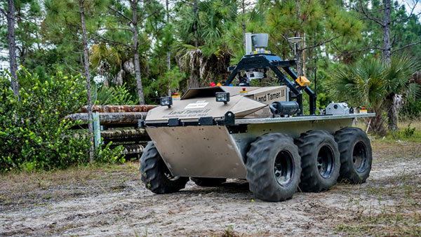


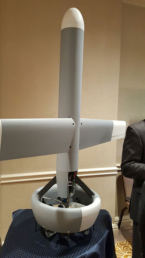


 By Tracy Cozzens, Managing Editor