Hurricane Helene has caused widespread devastation across the southeastern United States, leaving a trail of destruction more than 500 miles long from Florida to the Carolinas. The storm made landfall at the Big Bend of Florida, on Sept. 26, 2024, as a Category 4 hurricane with sustained winds of 140 mph.
The death toll has risen to at least 215 across six states, with hundreds more still unaccounted for, reported ABC News. More than 4.5 million people initially lost power due to the hurricane, with more than two million residents still without electricity days after the storm. Utility companies face significant challenges in restoring power due to blocked and damaged roads. The storm’s destruction has rendered many essential roads and bridges impassable, complicating recovery efforts.
Role of GNSS in Recovery
GNSS plays a crucial role in disaster recovery operations. These systems provide essential positioning, navigation and timing (PNT) services critical for search and rescue efforts such as flood monitoring. GNSS technology enhances emergency services by enabling synchronized communication networks, providing precise location information and allowing for faster response times. With cell towers and electrical services down, GNSS empowers virtually all disaster recovery efforts.
Over the years, our reliance on GNSS has increased into an aspect of life we often overlook. Its importance is emphasized in times of disaster, PNT is critical.
A recent public safety announcement issued by the Space Force highlights that a critical component of any successful rescue operation is time. Knowing the precise location of landmarks, streets, buildings, emergency service resources and disaster relief sites reduces the time it takes to navigate challenging terrains to save lives. This information is critical to disaster relief teams and public safety personnel in order to protect life and reduce property loss. GPS serves as the fundamental technology in addressing these needs.
The United States Geological Survey (USGS) is also collecting flood data and repairing damaged streamgages to monitor water levels after Hurricane Helene.
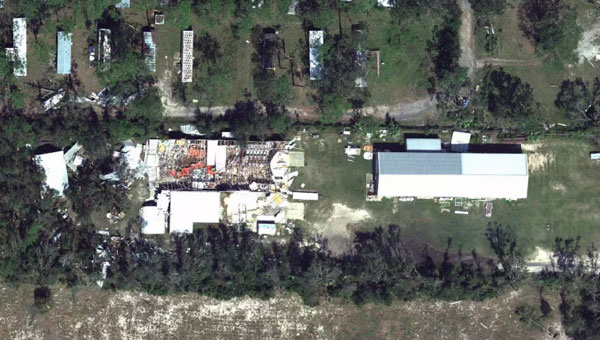
USGS Mapping the Aftermath
As of Oct. 7, USGS provisional streamgage data indicates that at least 34 new flood records were set across the southeast from flooding caused by Helene. Eighteen of these provisional records were set in North Carolina, with six in Tennessee, six in South Carolina, three in Florida and one in Georgia.
In Newport, Tennessee, USGS field crews were able to measure high-water marks left behind by flood waters and determined the Pigeon River reached a provisional peak water level of 29.72 ft. The previous record on this river was 21.40 ft, set in 1902.
As communities begin the long process of rebuilding, they face numerous challenges, including limited resources, prolonged power outages and disrupted communication systems. However, GPS serves as a backbone in the recovery process, highlighting its significance in times of disaster. The full extent of Hurricane Helene’s impact is still being assessed, with authorities warning the death toll may continue to rise as search and rescue efforts progress.
The United Kingdom’s Ministry of Defence (MOD) is focusing its alternative positioning, navigation and timing (Alt PNT) project on deployable eLoran. This comes after industry days for Alt PNT in March and June 2024.
The announcement came in a Request for Information (RFI) on Sept. 20. It specifies that a contract will be let for the development of a deployable eLoran network. As part of that contract, the MOD also wants to develop:
A modelling capability, which will allow for theoretical analysis of capabilities and informing the concept of employment.
An assured capability within the Loran Data Channel
Information and demonstration of the resulting capability to stakeholders
UK PNT Policy Framework
Last year, the UK government announced a ten-point “policy framework” for advancing the nation’s PNT resilience. One of the ten points is:
“Develop a proposal for a resilient, terrestrial, and sovereign Enhanced Long-Range Navigation (eLORAN) system to provide backup position and navigation.”
Most have seen this as a provision for a fixed domestic system for use by critical infrastructure and applications. The UK already has an on-air single eLoran transmitter that provides a timing signal. An announcement about establishing two or more additional transmitters to provide PNT services for the British Isles and their adjacent waters has been anticipated.
The policy framework also includes:
“Develop a proposal for ‘MOD Time’ creating deeper resilience through a system of last resort and use NTC-provided timing to support MOD.” [NTC stands for National Timing Centre.]
It is not immediately clear how this RFI from the MOD fits these two provisions, if at all, or is entirely separate.
1970s Deployable Loran
Deployable Loran, or Loran-D was first developed for the U.S. Air Force in the 1970’s. An oral history recounts that a system was deployed early in the 70’s by the 6514th Test Squadron at the Utah Test and Training Range (UTTR), a component of Hill Air Force Base. It was built by Megapulse, employed a Hewlett Packard beam clock and 150 ft antennas, and was used for testing unmanned aircraft. There are also indications elsewhere that the Air Force used it for precision bombing.
Industry sources say that this earlier work provides a solid foundation for developing future deployable eLoran systems.
UK MOD Requirements
The RFI is fairly specific about the questions it wants answered. These requirements look nearly ready to be transformed into a Request for Proposal and contract language. They include:
The demonstrator system shall include a minimum of 3 transmitters to enable a suitable receiver to live demonstrate position and time determination from the system.
Across the coverage area, the system shall transmit a signal that allows receivers to achieve position and timing accuracy in line with the needs of defense platforms (which have not yet been specified).
The system shall be able to operate with and without GNSS access.
The system shall be able to operate both with and without access to eLoran signals from eLoran transmitters outside the deployable system’s group.
The system shall be capable of maintaining performance & accuracy for prolonged periods, including without access to eLoran and GNSS signals.
The system shall be able to be contained and transported in an ISO container.
The system shall be able to be assembled, initialized and disassembled by as small a team as possible.
Respondents must submit by the 18th of October to be considered.
The increasing prevalence of GNSS spoofing in commercial aviation poses significant safety concerns and highlights the need for robust alternative positioning, navigation and timing (A-PNT) sources. This form of electronic warfare, which uses fake signals to confuse aircraft navigation and safety systems, has become a growing issue for civilian flights worldwide.
Pilots told The Wall Street Journal that spoofing incidents have risen in recent months. According to analyses from SkAI Data Services and the Zurich University of Applied Sciences, the number of affected flights per day increased from a few dozen in February to more than 1,100 in August 2024.
The issue of spoofing has expanded beyond active conflict zones near Ukraine and the Middle East, and now affects hundreds of civilian pilots daily on a global scale. The modern cockpit’s heavy reliance on GPS technology means that falsified data can have far-reaching consequences, breaching multiple aircraft systems and causing disruptions that may last anywhere from a few minutes to an entire flight.
According to anonymized reports shared with government agencies and industry groups, pilots have experienced many alarming incidents, including sudden clock resets, false terrain warnings and unexpected flight path deviations. This surge in GNSS spoofing attacks highlights the vulnerability of critical navigation systems and raises significant concerns about aviation safety in an increasingly complex environment.
All jammed up The Wall Street Journal reported that in August 2024, a United Airlines flight from New Delhi to the New York area encountered a GPS spoofing incident that affected its navigation systems for the duration of the flight.
Initially, the flight seemed to adhere to the standard GPS route across Asia, mirroring the path taken by previous flights heading to Newark Liberty International Airport. The spoofing attack, originating in the Black Sea region south of Ukraine, caused the aircraft’s GPS coordinates to deviate progressively from its actual position throughout the remainder of the flight.
Even after the plane had left the affected area, its reported GPS location continued to show erratic behavior, occasionally making sudden jumps. This suggested that the navigation equipment was struggling to recalibrate accurately. While alternative navigation systems ensured the flight’s safe completion of its intended route, the compromised GPS data indicated that it had terminated in the Atlantic Ocean. In reality, the aircraft landed safely at its scheduled destination in Newark.
Keeping operations safe Aviation safety officials said spoofing has disrupted some flights but has not posed major safety risks. Pilots are trained to use A-PNT systems as backups. However, managing false GNSS signals and alerts risks dividing the operator’s attention if a more severe problem arises.
“If we lose an airplane because of workload issues because of these problems we’re encountering, compounded with an emergency, that is going to be a horrendous event,” said Ken Alexander, the Federal Aviation Administration’s chief scientist for satellite navigation, during a pilot union forum in Washington, D.C.
Airlines are collaborating with aircraft manufacturers, parts suppliers, and aviation safety authorities to devise immediate solutions and long-term strategies. For example, the International Air Transport Association (IATA) and the European Union Aviation Safety Agency (EASA) are openly discussing these challenges and holding workshops to share best practices. Safety bulletins have also been issued for operations where spoofing and jamming are known to have occurred.
Industry insiders told The Wall Street Journal that the development of new equipment standards to enhance civilian aircraft resilience against spoofing attacks is not expected to be finalized until 2025.
Navigating issues across sectors According to anonymized reports collected by OpsGroup, an aviation safety organization that includes pilots, dispatchers and other airline staff, various attacks have caused navigation issues across multiple sectors.
GNSS spoofing has disrupted operations in Europe but has not endangered flights, said Florian Guillermet, executive director of the European Union Aviation Safety Agency. Pilots had to divert to airports they did not intend to land at, and earlier this year, an airline temporarily halted operations at an Estonian airport that was not equipped with ground-based navigation as a backup for GNSS.
Boeing said manufacturers, carriers and regulators globally are contributing GPS expertise for solutions to ensure safety. Boeing and Airbus are working with airlines to help develop procedures to assist pilots, the companies said.
United and American said their pilots are equipped with several ways to navigate with precision, even with GPS interference. American said it has not experienced disruptions or significant safety concerns from GPS interference.
Insights from industry experts
During the 64th Civil GPS Service Interface Committee Meeting — hosted at ION GNSS+ 2024 from Sept. 16-17 — The presentation “Complementing GNSS for Resilient Performance Based Navigation” by Okuary Osechas Ph.D., and Gary A. McGraw, Ph.D., addressed the critical role of complementary positioning, navigation and timing (CPNT) technologies in aviation, particularly in light of increasing threats to GNSS.
The presentation highlights the impact of radio frequency interference (RFI) on aviation, including jamming and spoofing. These pose significant risks to aviation safety by reducing operational margins. The prevalence of these threats is increasing, necessitating alternative navigation solutions.
Performance-based navigation (PBN) is essential for modern aviation, enhancing efficiency and flexibility. However, it relies heavily on GNSS, making it vulnerable to disruptions, again highlighting the need for CPNT services.
Integrating CPNT sources ensures resilient navigation capabilities. This includes leveraging legacy navigation aids and modernized terrestrial systems. Various complementary technologies such as eDME, eLORAN, LDACS-NAV and LEO SATNAV are being assessed for their operational effectiveness, compatibility and potential to support aviation needs.
The researchers recommend the following to address these challenges:
Near-term solutions: Implementing eDME for backward compatibility. Medium-term strategies: Utilizing eLORAN for wide-area time distribution. Long-term goals: Developing LDACS-NAV to enhance spectrum efficiency and standardization. Collaborative efforts: The presentation calls for international cooperation in research and development to advance standards and infrastructure investments in complementary PNT technologies.
Mitch Narins’ answer to the question, “If not GNSS, then what?” in the August 2024 issue’s EAB Q&A column, conveys an important message. As a result of their quality and availability, services offered by GNSS create dependencies and subsequently the expectation that of course they must always be there. However, recent experiences have shown we cannot rely on that expectation because either natural or hostile occurrences can disrupt GNSS services, no matter what measures are taken to protect them. That is why the U.S. Department of Defense (DOD), in its “Strategy for the DOD PNT Enterprise,” assessed that, “To combat man-made and natural threats to GPS, other sources of PNT information will be necessary to assure continuous PNT service …”
The strategy describes a layered PNT architecture using global (GPS), regional (eLoran), and local (or self-contained) sources of PNT information. It states, “The global PNT layer is space-based and available worldwide. The regional PNT layer may be implemented in areas … where PNT resiliency must be assured with backup capability. The local layer provides PNT information using man-made and natural information sources available for a limited time or over a limited area.” To achieve resilience from this layered architecture, the strategy provides an integration concept in which GPS and other GNSS are individually integrated with PNT information from the other layers into resilient applications to operate through the hostile environments they will encounter.
Unfortunately, the U.S. government is ignoring a major piece of this layered strategy in favor of space-based and local or self-contained solutions, as it has dismantled virtually the entire legacy Loran infrastructure in the United States and completely in Alaska, although GPS backups are lacking in the Arctic and northern Pacific regions. The loss of the Alaska sites is particularly concerning as the Arctic and northern Pacific Ocean coverage they would provide is a valuable backup to vulnerable GPS signals at a time when other nations are eying the sea lanes north of Alaska/Canada and conducting excursions around the Aleutian Island chain and the Alaskan coast. Coincidentally, the DOD has just published a new “Arctic Strategy,” which requires availability of PNT from GPS (at least) for its success, though “PNT” is not mentioned. However, without effective PNT, whether from GPS or other sources, the systems on which the strategy depends will fail.
As Mitch notes, there are those GNSS advocates who see strengthened GPS/GNSS as the best answer – but real-world events highlight the need for diversification, and now other nations are expanding their Loran-based regional systems. For its Arctic interests and domestic critical infrastructure as well, the U.S. must wake up to reality and do the same.
A little clarity recently emerged regarding how U.S. Loyal Wingman or Collaborative Combat Aircraft (CCA) unmanned fighter support vehicles will be initially configured. The emerging concept is that CCA would fly alongside F-35 Lightning II and F-22 Raptor carrying various Advanced Medium-Range Air-to-Air Missiles (AMRAAM) and AIM-9 Sidewinder missiles.
Kratos Valkyrie CCA flying with F-35 and F-22. (Photo: Kratos)
While both the F-35 and F-22 carry their own missiles, when their payload is expended, operators can continue the fight by firing AMRAAM and AIM-9 ordinance on the CCA “missile truck” flying alongside them. This means that the manned-unmanned team can bring twice the number of missiles to bear on an adversary. According to mission planning revealed in early 2023, the US Air Force (USAF) plans to pair two CCA vehicles with each manned front-line fighter aircraft – with at least 1,000 unmanned CCA vehicles being brought into USAF inventory.
The potential suppliers of CCA unmanned aircraft include Anduril and General Atomics Aeronautical Systems (GA-ASI). They are developing a CCA based on the GA-ASI XQ-67A prototype, which first flew in February 2024. Boeing Australia’s MQ-28A Ghost Bat Airpower Teaming System first flew in February 2021. Additionally, Kratos’ XQ-58A Valkyrie has been flying since 2022, and Northrup Grumman recently flew its manned-unmanned Loyal Wingman prototype Vanguard Model 437 on Aug. 29, 2024.
By incorporating full autonomy or being controlled by manned aircraft, these CAA are also designed to fly ahead, avoid detection, perform advanced intelligence, surveillance, and reconnaissance tasks, provide early warning, and — when suitably equipped — conduct electronic warfare. The system is engineered to engage its own targets with or without its fighter teammates.
The U.S. House of Representatives has passed legislation that could significantly restrict the use of Chinese-made drones, particularly those manufactured by DJI, in the United States. On September 9, 2024, the House approved the Countering CCP Drones Act, a bipartisan bill .
The act aims to add DJI Technologies to the Federal Communications Commission’s (FCC) Covered List. If enacted, this would prohibit new models of DJI drones from operating on U.S. communications infrastructure. The bill is part of a broader effort to address potential national security risks posed by Chinese-made technology.
The legislation has passed in the House and will now move to the Senate for review. It may be included in the Senate version of the National Defense Authorization Act (NDAA) for Fiscal Year 2025. Senators Mark Warner and Rick Scott have introduced a related bill in the Senate, which also aims to blacklist DJI and other Chinese drone companies.
The proposed ban appears to target only new versions of Chinese drones, while existing models in the United States can still be flown by their owners within FAA regulations. Additionally, a new product with exactly the same design and an FCC license can still be purchased without restrictions. However, if the ban were to be implemented, newly designed products would be unable to obtain an FCC license to use U.S. communications.
DJI Mavic 3 (Photo: DJI)
Another bill, Drones for First Responders, does not go as far as to ban Chinese drones. Rather, it suggests adding a tariff to any imported drones. The revenue generated from the tariff would be used to encourage the purchase of U.S.-made drones or those manufactured in locations not on the U.S. list of restricted countries. This initiative is intended to support U.S.-based commercial operations, such as farmers and first responders, including firefighters, ambulance operators, and police. It is worth noting that all U.S. government departments are thought to have already dropped the use of any Chinese-made drones due to existing restrictions.
It seems okay to keep your existing DJI drone for your own private use or commercial operation and even replace it with another existing model as long as stocks are available — but it might cost more because of new import tariffs.
On quite an unrelated UAV subject – it seems that Swift Navigation has decided to leave the GNSS OEM business and has sold its Duro product line to Carnegie Robotics, which is folding the GNSS receiver business into its robotics and sensor product portfolio.
The two companies have collaborated since 2017, when they developed Duro high-precision GNSS receivers and software. When accompanied by the Swift Skylark Precise Positioning Service, Duro receivers may be augmented to achieve centimeter-level positioning accuracy.
It is great to see that Archer is making significant headway along its path to developing and enhancing the performance of its Midnight air-taxi eVTOL. Archer established a goal to achieve 400 test flights this year to get FAA certified by 2025. The company announced that 402 flights were already completed by August.
Flights have expanded the envelope of the aircraft for the transition from take-off to flight and vice-versa for landing, landing under varying wind conditions, tuning hover noise profiles, extending endurance by optimizing control laws, and of course, increasing the rate of test flights. These are normal developmental steps along the road to baselining the performance envelope, which will be used to certify the aircraft and, along the way, collect data that will flow into the certification program.
In summary, we have an outline of how Loyal Wingman UAVs may initially become missile trucks alongside front-line fighter aircraft, potential restrictions on Chinese drones in the United States, the sale of an OEM GNSS product line, and a high rate of flight tests for the Midnight eVTOL.
(Photo: Adam Smigielski/iStock / Getty Images Plus/Getty Images)
One of my favorite parts of this job — and, more generally, one of my favorite things to do in life — is to ask questions.
Matteo Luccio
For this magazine and to stay on top of the latest issues and trends in our industry, I ask questions to the members of our Editorial Advisory Board (EAB) for our EAB Q&A section, to representatives of GNSS/PNT companies for our cover stories, and to participants at conferences and trade shows.
In my personal life, I ask questions to people I invite on sailing trips, to dinner parties and on hikes. When I am traveling or just about town, if I overhear somebody knowledgeable speak about an interesting topic — from quantum mechanics to French politics to Baroque music — chances are that I will say, “Excuse me. May I ask you a question?”
So, here are a few of my current questions about GPS/GNSS/PNT. To make it clear that they are not in order of importance, I put them in alphabetical order.
How do the other three GNSS constellations benefit GPS users?
How is GPS faring in Congress? (On June 17, Dana Goward reported that Congress had refused the U.S. Space Force’s request to fund a program to make GPS more resilient by building and deploying small GPS satellites. Please note: I am looking for a knowledgeable “Washington correspondent” for GPS World, who could keep our readers updated on relevant developments in Congress and the executive branch.)
If the QZSS or NavIC regional systems became global, would that significantly improve GNSS? If so, how?
What are currently the most promising approaches to non-GNSS PNT for applications that do not require high accuracy?
What are the benefits of adding signals from even a few low-Earth orbit (LEO) satellites to a PNT solution?
What are the latest advancements in the scientific uses of GNSS signals, such as to develop models of the ionosphere or to test theories in fundamental physics, such as relativistic positioning?
What are the most promising approaches to pinpointing GNSS interference from LEO satellites?
What is the most promising approach to high-precision positioning with smartphones?
What is the status of the Chimera enhancement to the L1C signal? What benefits will it deliver?
What reforms in GPS governance would help accelerate modernization of the system?
When will M-code GPS user equipment be widely deployed to U.S. armed forces?
When will the Next Generation Operational Control System (OCX — the future version of the GPS control segment) become operational? What’s missing? What’s the holdup? (According to GPS.gov, the U.S. Space Force completed all 17 planned monitor station installations in July 2021.)
Which GNSS signals are cellphones in the U.S. legally allowed to use?
I will pose some of these questions to our EAB over the next few months. If anybody else out there would like to chime in, please let me know.
From Hong Kong to Berlin, from Sydney to New York, the operations of hospitals, airlines, banks, and scores of other businesses and services were disrupted on July 19 due to a glitch in a software update issued by the cybersecurity firm CrowdStrike that affected computers using the Microsoft Windows operating system.
TheNew York Times described it as “a stunning example of the global economy’s fragile dependence on certain software, and the cascading effect it can have when things go wrong.”
Regular readers of this magazine, and of this column in particular, will know where I am going with this: like Windows, GPS — and, more broadly, GNSS — presents a single point of failure for many systems. That is, if GPS fails, it will stop those entire systems from working.
Possible challenges and threats to GPS use include space weather; interference/jamming and/or spoofing of receivers; error or failure of satellites, monitoring, or control; and, in the most extreme case, an attack on satellites, monitoring, or control.
The National Space-Based PNT Advisory Board continues to focus its efforts on its excellent PTA strategy: to protect (“prevent or remove conditions that degrade, distort, or deny GPS use”), toughen (“make GPS use more robust against challenges and threats”), and augment (“provision of GPS enhancements as well as provision and use of alternate [PNT] sources that complement, back up, or replace (partly or entirely) use of GPS”) civil uses of GPS. More on that soon.
Meanwhile, others are urging we think of GNSS as only one of several complementary means to achieve the mission of positioning, navigation and timing (PNT) with accuracy, availability, integrity, continuity and coverage. For that perspective, see Mitch Narins’ piece. He writes that we should focus “on services that are not space-based, operate in different areas of the spectrum, are capable of higher power, and can be installed and evolved more quickly to mitigate emerging threats.”
The European Space Agency’s recent PNT Vision 2035 paper, written by a panel of independent external PNT experts to advise next year’s ESA Ministerial Conference, summarizes European discussions on PNT in the past several years. In the words of Luis Mayo, the chair of the advisory committee that wrote the report, “there is more to PNT than satellite navigation.” While we must “sustain the existing satellite-based navigation systems,” he argues, we should also promote “the development of alternative independent PNT systems.” Read a short interview with Mayo by Dana Goward, starting on page 19.
Yet other efforts integrate GNSS with different, independent techniques to create new synergies. One example is ESA’s Genesis multi-modal space mission, which aims to improve geodetic applications by collocating on board a single well-calibrated satellite the four space-based geodetic techniques: GNSS, very long baseline interferometry (VLBI), satellite laser ranging (SLR) and Doppler Orbitography and Radio-positioning Integrated by Satellite (DORIS).
“This first-time collocation in space will establish precise and stable ties among these key techniques,” write the authors of this quarter’s “Innovation” column.
If not GNSS, then what? That is an interesting question.
To some, it means GNSS is so important and unique that without it, all is lost. They enthusiastically support only GNSS-centric research and development, believing that any issues that GNSS has today — such as lack of resilience — can be resolved given enough time and money. It includes pushing for the discontinuance of ground-based systems and the “re-purposing” of their resources to produce more satellites and more space-based signals. It demonstrates an admirable and true dedication to the belief that GNSS is the mission.
To others, these words have a different and darker meaning, warning of a clear and present danger. To them, it means “When (not if) GNSS is not available, what other source(s) of positioning, navigation and timing services (PNT) will be available to support GNSS users’ missions and goals?” For these purpose-driven individuals, GNSS is a means — not the mission, which is to provide the necessary positioning, navigation and/or timing performance, such as accuracy, availability, integrity, continuity and coverage, required to ensure the nation’s safety, security and economic well-being.
Unfortunately, some who have made GNSS their mission strive to convince others that it should be their mission, too!
GNSS is magic — but only when it works. It has played and will continue to play a crucial part in advancing our knowledge and abilities and supporting diverse use cases worldwide. It should and must be supported, but not to the exclusion of everything else. Recently, the magic has failed numerous times all around the world and, as a PNT community of suppliers and users, we must know we are capable of so much more.
We also know that the vast majority of civil PNT service needs are local, not global — based in part on the population density of users and their use cases. Over the years, GNSS’ accuracy and coverage have spoiled us. We even chose to see GNSS interference events as proverbial “black swans.” At the same time, the abandoning of well-engineered, resilient local solutions in favor of a global, one-size-fits-all mentality has been appealing to many. We know this approach is fraught with danger. Throwing away perfectly acceptable, resilient local means rather than enhancing them and bringing their technology into the 21st century may, as a PNT community, be our biggest regret. In many ways we have already gone too far.
I encourage our PNT community to commit to doing more, to open up our minds to design, develop, evolve, create, install, implement and operate more resilient PNT sources and more resilient user systems for which PNT services are critical inputs — especially by focusing on services that are not space-based, operate in different areas of the spectrum, are capable of higher power, and can be installed and evolved more quickly to mitigate emerging new threats. Most importantly, we all need to accept and support the true mission of our PNT community, the “why” that drives our innovative solutions: to ensure PNT services always will be available to support our safety, security and economic well-being.
The top screen showing the hydrogen maser and cesium clocks in an adjacent isolated room used for realization of the timescale for research purposes. Students presenting their work to the USNO and Microchip Inc., visitors. (Photo: University of Alabama, Tuscaloosa)
The University of Alabama, with the support of the National Science Foundation (NSF), has established a program unlike any other in the country. It focuses on positioning, navigation, timing, and frequency (PNTF) as its own discipline, with a special emphasis on precise timing.
The Alabama Collaborative for Contemporary Education in Precision Timing (ACCEPT) is an NSF Research Traineeship (NRT) program designed to train the next generation of graduate (master’s and Ph.D.) degree holders in PNTF.
ACCEPT provides interdisciplinary training and education for physics, engineering, mathematics and computer science majors. The school hopes to make it a graduate program eventually. Enrollees are awarded a fellowship that includes a $34,000/yr stipend.
“The ACCEPT program was created because industry and government officials told us they could never find enough people in this field,” said Adam Hauser, the program’s executive director, who is also an associate professor of physics and astronomy at the university. According to Hauser “It is the only program in the nation directly addressing a larger scale workforce development in precision timing.”
Left to right: Dr. LeClair, Dr. Hauser and Dr. Bandi founded and run the ACCEPT PNT program at University of Alabama. (Photo: University of Alabama, Tuscaloosa)
ACCEPT’s Technical Director — also billed as “Time Lord” — is Thejesh Bandi, an associate professor. He reinforces Hauser’s message about the scarcity of focused talent in the area. “This field is greying,” he says. “We need young minds who will also bring in fresh ideas.”
Hauser describes the program as “a flexible multidisciplinary course curricula that includes professional development, and real-world training with our industry and government partners.”
The program’s “interdisciplinary” nature is reflected in the ACCEPT team. In addition to physics and astronomy, faculty from mathematics, electrical and computer, civil, aerospace, and mechanical engineering, as well as the communications and higher education departments, are included.
This diversity of expertise is needed for ACCEPT’s ‘holistic education” approach founded on four pillars.
Industry-Directed Curriculum: First, because the goal is to supply qualified graduates to fill critical national needs in industry, the foundational curriculum is based on and will continue to evolve with input from commercial entities in the PNTF space. In addition to several government agencies and labs, the ACCEPT Advisory Board includes representatives from SpectraDynamics, Aerospace Corporation, Raytheon Technologies, Microchip Technologies, L3Harris Technologies, OEWaves, Inc, Safran S.A., Northrop Grumman Corporation and the Resilient Navigation and Timing (RNT) Foundation.
Sustained Industry & Community Immersion: The program’s major focus is moving beyond academia. Internships and PNTF professional community events are mandatory. Students attend the National Institute of Standards and Technology (NIST) Time and Frequency Division’s time and frequency seminar each year. In their second year, they begin attending the Institute of Navigation’s annual Precise Time and Time Interval (PTTI) meeting. As their research and professional skills mature, they are expected to progress from attendees to poster presenters and speakers.
Professional Development: Reinforcing preparation for moving beyond the classroom, ACCEPT trains students to “… effectively work across academic, policy, governmental and industry sectors,” according to Hauser. “They need to be able to advocate as a professional to a larger audience effectively.” This means including students in programs like the university’s Speaking Studio and Capstone Center for Student Success. Communication skills, teamwork and ethics are particular focus areas.
Research: Bandi’s Research Quantime Lab is hosted by Professor Patrick LeClair’s Department of Physics and Astronomy. “Research projects for ACCEPT fellows and trainees are designed in conjunction with our government and industrial partners and focus on cutting-edge innovations that solve today’s problems in currently used technologies,” Le Clair said.
The lab strongly focuses on Quantum Engineering research, though there are also opportunities in Characterization and Calibration, Networking and Synchronization, and research into Precision Devices.
Click here for more information about applying for an ACCEPT fellowship or becoming an industry partner.
In June, the Navigation Innovation and Support Program (NAVISP) Advisory Committee (NAVAC) of the European Space Agency (ESA) issued a paper titled PNT Vision 2035. It provides an interesting overview of the state of positioning, navigation and timing (PNT) and where it will be a decade from now.
According to ESA’s website, key findings in the paper include:
Increasing Dependence on PNT Services – particularly for consumer and autonomous solutions. Accurate timing remains a critical use case, especially in telecom and power distribution.
Geopolitical and Technological Challenges: Rising cyber-attacks, jamming and spoofing, advancements in AI, ML and quantum computing will have significant impacts. Anticipate new regulations.
Technological Trends Driving PNT Demand: The proliferation of connected devices (IoT), autonomous driving, advanced air mobility, smart grids and autonomous vehicles will drive the demand for resilient and robust PNT.
System Architecture Evolution: Future PNT systems will utilize a combination of data sources, including multiple GNSS constellations, cellular networks (5G/6G), terrestrial systems, augmentation systems, and autonomous sensors. This “system of systems” approach will enhance performance and ensure independence from single points of failure.
Emerging Technologies and Sensor Integration: Advances in space segment technologies, receiver designs and sensor integration, new signal designs, flexible payloads, advanced clocks, inter-satellite links, and higher power amplifiers are highlighted.
Luis Mayo
We spoke with Luis Mayo, NAVAC’s chair, to get his take on this seminal work.
Question: To set the stage, what is NAVAC?
Luis Mayo: NAVAC is a group of external PNT experts that ESA has assembled to provide independent advice on navigation issues, and especially for NAVISP.
Q: Where can NAVAC’s formal recommendations be found?
Mayo: We perform an assessment of the NAVISP status every two years. We provide our recommendations as a conclusion of this assessment. Beyond that, our formal recommendations are collected in documents like this white paper or in proposals for modifications or adjustments to the work plans of the programs.
Q: How does ESA leadership generally view and react to NAVAC conclusions and recommendations? Does it act upon every recommendation?
Mayo: They are generally receptive. However, we are just an advisory body, so it is up to them to take on our recommendations. They often do so and use our advice to add weight to their proposal to the Navigation Programme Board, but they do not necessarily have to.
Q: PNT Vision 2035 is a substantial document. Clearly it involved some time and effort. Why was it written? Is it something ESA requested?
Mayo: The paper was the initiative of NAVAC members to inform the ESA Ministerial Conference in 2025. These conferences take place every three years to define the roadmap for the next period. New European space programmes, extensions or redirections of existing ones, and budgets are approved at these meetings.
Q: We thought we might make a modest contribution to the definition of the future ESA navigation programmes. What, if anything, did NAVAC find surprising or unexpected about findings included in the Vision?
Mayo: I would say that we hardly found anything too unexpected or surprising. The findings are the conclusion of multiple discussions on the subject over the past few years. We have just expressed them in a more articulated way.
If anything, and from my personal perspective, I would like to highlight that this exercise helped me realize that the deployment of some of the most exciting or expected applications of PNT technologies — such as autonomous driving — depend on the development and deployment of multiple other technologies that might not be necessarily available in the mid-term.
AVAC’s first meeting in 2018. From left to right: Javier Benedicto, ESA Navigation Director, and NAVAC members Alessandra Fiumara, Peter Grognard, Giorgio Solari, Rafael Lucas Rodriguez, Pierluigi Mancini, Roger McKinlay, Stefano Debei, Nityaporn Sirikan, Bernd Eissfeller and Luis Mayo. (Photo: ESA)
Q: What are the three most important things policymakers should understand from the document?
Mayo: First is that many infrastructures or services critical to the daily lives of the citizens are dependent on PNT technology.
Second, they cannot take for granted that GPS or Galileo services will be always available, not to mention GLONASS or BeiDou. Satellite navigation systems are vulnerable and are continuously under threat. Enabling assured PNT service is a must.
And third, there is more to PNT than satellite navigation. Other complementary or alternative technologies should not be abandoned. In fact, some of those technologies might even change the way in which we have traditionally conceived satellite-based navigation.
Q: What are the most important things policymakers should do to enable the PNT needed by 2035?
Mayo: I think they have to sustain the existing satellite-based navigation systems and foster the development of new technologies and systems that improve the robustness of the services. We have done a lot so far to provide PNT services globally. When you come to think of that, it’s really wonderful what we have achieved this far. We cannot afford to lose what we have, but that has proven not to be enough. Therefore, policymakers should keep helping the development of new technologies and services that complement what we have, improve the quality of the services and ensure its continuous availability and integrity.
They should also look beyond the current service volume. Spacefaring nations should be aware of the fact that they will need this kind of technology to support future missions. Deploying systems able to provide PNT services beyond the coverage of the current GNSS is an absolute necessity to support such missions.
Q: The vision says the EU must consider no longer having access to GLONASS and BeiDou. There are a number of threats that are common to all GNSS. Why not consider loss of access to all either temporarily or permanently?
Mayo: We have not considered a completely catastrophic situation such as losing access to all GNSS in our vision. We understand that GPS, Galileo and eventually other constellations or augmentation systems will remain available and provide at least partial coverage for PNT services.
Q: The vision makes recommendations about mitigating interference, using AI and extending the GNSS service volume. What else should policy and technology decision-makers take from the document and act upon?
Mayo: We must not forget there is a clear case for investing in future PNT systems. ESA should keep up to pace with foreign competitors that seem ready to increase their expenditure in these types of problems.
They also have to be conscious that satellite-based navigation is not enough. We have to look for alternative and complementary systems to reach the level of confidence that we need on PNT solutions.
Q: Perhaps you are thinking of all the PNT systems China has deployed?
Mayo: I am really thinking about what we are not doing in Europe or in the United States. We need to build alternatives that might not have global coverage but would allow us to maintain essential PNT services running at home.
Q: Resilience seems to be an important theme in the document, but it was not the subject of a specific recommendation. Could you speak to that?
Mayo: Resilience is a pervasive theme throughout the whole document. This is a major concern. We have to find a way to build a system of systems that can deliver to the user a trustworthy PNT solution at any time.
Resilience is, today, a key consideration in PNT, and we cannot do anything but acknowledge this fact. We might not have insisted enough on the importance of this feature for future PNT systems, but policymakers must undertake any actions required to improve the resilience of the existing PNT systems and services, probably by promoting the development of alternative independent PNT systems.
Q: What else should GPS World readers know about the Vision?
Mayo: Read the document. It is not that long. Also, think that it has been written from an independent and experienced standpoint. We at NAVAC do not pretend to hold the full truth, but I believe that we have a quite comprehensive view of the matter and that this would be useful for the reader.
Many of us have had to call for emergency services, whether as a bystander, for a loved one, or ourselves.
In that moment, you are focused on being able to communicate with someone who can send emergency personnel to your exact location. As fast as possible. GPS plays a part in all three – communicating with someone, defining your exact location, and reaching you as fast as possible.
Timing signals from GPS satellites are critical to our communications networks, allowing callers to communicate with emergency services. This is because cell phone networks rely on GPS timing receivers to keep all their base stations perfectly synchronized, which allows mobile handsets to share limited radio spectrum more efficiently.
Location is one of the most important pieces of information on which first responders depend to provide timely emergency services. “Every minute counts” encapsulates the benefits accrued from integrating information derived from GPS signals into the emergency services infrastructure. To illustrate the importance of this information, the Federal Communications Commission’s (FCC’s) January 2024 Report and Order on location-based routing for wireless 911 calls estimates this technology will improve call time responses by up to a minute, saving nearly 14,000 lives annually. Outdated systems — still operating in many areas — use cell towers, which can be as far as 10 miles away, as a reference point
for the caller’s location to dispatch emergency services. These systems misroute more than 20 million calls annually, wasting precious minutes in locating those in need. Updating these systems will enable first responders to efficiently locate and navigate to the person in need.
It is critical that federal, state and local governments continue to fund the adoption and operation of innovative, timesaving and accurate solutions to better serve the public. Your loved ones deserve nothing less.
Coming Soon: Next Generation 911
One of the ways in which GPS is being used in emergency response systems is through Next Generation 911 (NG911), a service that makes more precise location information widely available to first responders. Once fully implemented, NG911 will provide dispatchers real-time locations derived from callers’ phones and accept text messages, videos, and photos. Why is this important? NENA: The 9-1-1 Association, estimates 80% or more calls are placed from GNSS-enabled cell phones.
More than 40 states have begun to adopt NG911, according to an April 2024 Congressional Research Service report. Most of these states are still in the early stages of implementation. Many call centers continue to use legacy systems that do not use technology optimized to save lives.
A GPS III satellite model provided by GPSIA member Lockheed Martin was on display at the NG911 Institute’s Technology Showcase this spring, reminding attendees of the important role GPS satellites play today and in future NG911-enabled emergency services.
Accessible Emergency Services Serve Everyone
To bridge this gap between adoption and full implementation of NG911, third-party groups and regulators are jumping in to make vital improvements. Organizations such as accesSOS, a non- profit started by Gabriella Wong, shed light on the need for more accessible emergency services. Wong was inspired to develop the accesSOS app after her deaf father was left unable to call for help in two emergency situations. Today, approximately 50% of 911 call centers in the United States cannot accept text messages. accesSOS allows deaf and hard of hearing individuals to quickly describe their situation through an easily navigable user interface, which is then translated into a phone call made to 911 on behalf of the person in need. accesSOS uses GPS location data collected from phones to bridge the accessibility gap between areas that are using outdated systems and individuals who are left unattended by those systems.
accesSOS’ solution, along with many other ones, were on display at NG911 Institute’s Technology Showcase, including GPSIA member Garmin’s inReach-enabled devices. This service supports more than 210 dialects and languages and is available in more than 200 countries and territories. By supporting a vast array of languages, Garmin’s inReach technology exemplifies another aspect of accessibility where regulators can take additional action — overcoming language barriers.
In the United States, it is estimated that non-English speakers face wait times of 5-10 minutes when trying to connect with emergency services in their native languages. In some emergency situations, those minutes can be the difference between life and death. Industry is leading the way by ensuring personnel at their call centers can communicate in multiple languages with people who need help, regardless of the language they may be speaking.
By continuing to promote GPS- enabled solutions such as accesSOS, NG911, and inReach, we are ensuring the safety of our communities and our loved ones. The GPS Innovation Alliance (GPSIA) is proud to support the further integration of GPS into the emergency services infrastructure by uplifting innovative research and design efforts and promoting new ideas that provide lifesaving services to users across the globe.
When Highly Accurate Location Information is Not Appropriate
While providing a highly accurate location for a caller is essential to certain types of emergency response services, such accuracy is not warranted when calls are made to 988, the Suicide and Crisis Lifeline. Since its nationwide rollout in July 2022, the Lifeline service has routed more than 9.6 million calls, texts and chats to crisis centers.
Preserving the caller’s privacy while quickly routing the call to the nearest crisis center is of the utmost importance. To preserve privacy, the caller’s precise location should not be shared. However, routing a call to a crisis center associated with the caller’s
area code — not disclosing the caller’s location — is not the answer either because the portability of mobile phone area codes has decoupled area codes from caller location. To address these shortcomings while preserving the caller’s privacy, the FCC has adopted a Second Further Notice of Proposed Rulemaking suggesting that wireless carriers route 988 calls to nearby crisis support centers using the location of the nearest cell tower, which can be located within 10 miles of the caller, rather than using a device’s location or the caller’s address.
GPS is still integral to communications between the caller and Lifeline. This case illustrates how diverse GPS-enabled technologies and solutions support a wide range of emergency response services.
If you or a loved one is experiencing a mental health crisis, please dial or text 988 to reach a crisis counselor.
Describing a dangerous “asymmetric vulnerability to navigation warfare” a recent paper from the National Security Space Association (NSSA) calls for a wide variety of actions to mitigate the threat. The most important, “Focused leadership, properly empowered and resourced…”
The nineteen-page paper, in some ways, reads like a primer on GPS and positioning, navigation and timing (PNT), providing background and context for policymakers unfamiliar with the technology and the United States’ broad dependence upon it.
“Long-standing lack of progress on issues important to U.S. national, homeland, and economic security.”
The lack of focused leadership, according to the paper, is evidenced by long-standing failures to follow through on a variety of mandates from senior leadership over the course of the last 20 years. Quoting from the Federal Radio Navigation Plan, it cites persistent shortfalls in national capability as including:
Sufficient accuracy and integrity in electromagnetically impeded environments — including operations during spoofing, jamming, and natural and unintentional interference.
Higher accuracy with high integrity; timely notification/alarming when PNT performance is degraded or misleading, especially for safety-of-life applications or to avoid collateral damage.
Ensuring PNT services, including supporting information technology (IT) infrastructure and supply chain are protected from cyber threats
Ability to accurately locate sources of intentional and unintentional interference in a timely manner.
Insufficient resilience and survivability when GPS services are unavailable or untrusted.
“American society has been transformed by the availability of GPS.”
The paper describes four decades of GPS being incorporated into virtually every technology and used by every critical infrastructure. It calls the harm to society should it be lost “incalculable.” It also notes that the operation of many space systems that support critical infrastructure and/or critical national applications is itself dependent upon GPS for proper operation.
The military utility and advantages brought by GPS are also discussed. These include:
Its role as the lynchpin for precision strike.
Enabling “… the maneuver, synchronization, and massing of effects from dispersed forces.”
PNT to achieve information and decision superiority over an adversary.
“Merely the threat of disrupting GPS services might be enough to impact U.S. national security and foreign policy.”
The paper says recent actions by and ongoing threats from adversaries of the United States are a critical concern.
Electronic warfare (EW) and cyber attacks by Russia, China, Iran, and North Korea demonstrate the ease and effectiveness of such vectors, as well as the seriousness of the threat.
As one example, Russia’s impending launch of a nuclear-armed anti-satellite weapon has the potential to both destroy or damage GPS satellites nearby and interfere with radio communications. NSSA recently published a paper on the Russian nuclear ASAT threat.
A potentially even more serious threat would be if Russia should deploy a nuclear-powered directed energy or electronic warfare weapon. Such a device would be “reusable” and could threaten an even larger number of space platforms or, in the case of an EW device, both space-based and terrestrial receivers.
“GPS blackmail”
The paper posits that the United States’ overdependence on GPS is so great that it could be subject to “GPS blackmail.” It suggests that this may already have occurred.
Prior to Russia’s invasion of Ukraine, it destroyed a defunct satellite with a ground-based missile, creating thousands of pieces of debris. Shortly thereafter, state-sponsored TV announced that Russia would destroy all 32 GPS satellites if NATO “crossed its red line.” Despite 90,000 Russian troops massing along the border, “U.S. officials decided against sending certain military equipment to Ukraine to avoid provoking Russia.”
“…could have cascading effects which unravel America’s socioeconomic fabric…”
NSSA warns that U.S. “critical infrastructures, national essential functions, and military forces could be at grave risk.” Among the impacts of a major GPS disruption, it counts:
Loss of U.S. political prestige and influence.
Degradation of the informational element of national power (IT and telecommunications).
Severe socioeconomic implications. “given the integration of GPS into critical infrastructures and their interdependencies, lengthy disruption just of the power grid, for example, could have cascading effects which [would] unravel America’s socioeconomic fabric…”
Harm to national and homeland defense. Leadership is needed to perform national essential functions.
While the paper makes several specific recommendations for actions by various departments, it also identifies national-level leadership as key:
“The United States must rapidly develop and implement a comprehensive, whole of nation, strategy to redress its asymmetric vulnerability to Navwar and restore U.S. leadership in space-based and terrestrial PNT. … Focused leadership, properly empowered and resourced, is essential to the national PNT strategy’s success.”
The NSSA paper “America’s Asymmetric Vulnerability to Navigation Warfare: Leadership and Strategic Direction Needed to Mitigate Significant Threats” was sponsored by the Resilient Navigation and Timing Foundation and can be accessed here.