All maritime navigators (should) know by heart Rule 5 of the 1972 Convention on the International Regulations for Preventing Collisions at Sea (Colregs for short): “Every vessel shall at all times maintain a proper lookout by sight and hearing as well as by all available means appropriate in the prevailing circumstances and conditions so as to make a full appraisal of the situation and of the risk of collision.”
Analogously, now that positioning, navigation and timing (PNT) data have become essential to the functioning of critical infrastructure and many other aspects of advanced industrial economies, it is imperative that we use “all available means” to maintain and improve that data’s accuracy, integrity, availability, continuity and coverage.
Given the inherent limitations of GNSS and the growing threat of jamming and spoofing, those means must also include other technologies, both legacy and emerging — such as L-band and S-band broadcasts from GEO and LEO satellites, fiber-optic timing systems, optical-based absolute positioning solutions, map-matching databases, inertial measuring units (IMUs), ultra-wideband and terrestrial radiofrequency (RF) technologies across low frequency (LF), medium frequency (MF), ultra-high frequency (UHF) and Wi-Fi/802.11 spectrum bands.
In March 2024, the U.S. Department of Transportation (DOT) — the lead for civil PNT requirements in the United States — released its updated Complementary PNT Action Plan: DOT Actions to Drive CPNT Adoption. It builds on Executive Order 13905, Strengthening National Resilience Through Responsible Use of Positioning, Navigation, and Timing Services; Space Policy Directive 7, The United States Space-Based Positioning, Navigation and Timing Policy; and DOT’s own 2021 report to Congress, Complementary PNT and GPS Backup Technologies Demonstration Report.
DOT’s Action Plan establishes five broad lines of effort:
1. Stakeholder engagement
2. Specs and standards development
3. Field trial and test range development
4. Establish a Federal PNT Services Clearinghouse
5. Domain-specific CPNT Services acquisition support
The plan explicitly extends the National Space-Based PNT Advisory Board’s chosen strategy of “protect, toughen, and augment” (PTA) to “protect, toughen, augment, and adopt” (PTAA).
It points out that “[s]trengths and vulnerabilities of existing complementary PNT sources can vary based on the specific application and operating environment.” For example, a ship at sea need not worry about multipath and can tolerate relatively large position errors that are unacceptable for, say, an autonomous car. The latter, however, can take advantage of nearby transmitters for ground-based solutions, as well as landmarks for self-localization. Different options for different needs.
On the last page, in a chart illustrating its “preliminary milestones and functional activities associated with implementing this action plan,” DOT lists eLoran infrastructure as one of the areas of R&D — starting with a demonstration project in the last quarter of 2023 followed by, in 2024 and 2025, “evaluate eLoran service against CPNT measures of effectiveness.”
The Air Force Research Laboratory (AFRL) has sponsored the development of two unmanned vehicles aimed at accompanying and augmenting the capability of today’s front-line fighter/bomber aircraft. The Loyal Wingman story just took another step forward with the first flight of the General Atomics Aeronautical System Inc. (GA-ASI) developed X-67A at the company’s Gray Butte Flight Operations Facility near Palmdale, California.
General Atomics/AFRL X-67A in flight (Photo: Air Force Research Laboratory Public Affairs)
Little is currently known about the AFRL/GA-ASI unmanned aircraft, other than indications that it has been developed under a Collaborative Combat Aircraft (CCA) program and built on a common frame, which is intended to aid the rapid development of future new variants.
AFRL has previously sponsored Kratos to develop the XQ-58A Valkyrie, which is also intended to “work in teams with manned aircraft,” as a low-cost “attributable” asset commanded by a manned flying companion. The aircraft launches by rocket assist and is recovered vertically by parachute – the new ‘trolley’ launch capability allows the jet-powered Valkyrie to take off on a regular runway.
In earlier flight testing, communications between Valkyrie and both an F-22 Raptor and an F-35 Lightening front-line manned aircraft were established, demonstrating the manned/unmanned teaming concept. With a range of roughly 3,000 mi and an operational ceiling of 44,000 ft, the Valkyrie is intended to demonstrate how an armed, low-cost UAV can bring significant additional assets into combat situations. However, the original test article is now retired and has been put on display at the National Museum of the USAF in Dayton, Ohio, so its demonstration days appear to be over.
XQ-58A Valkyrie. (Photo: AFRL)
Nevertheless, Kratos has built several other production Valkyrie UAVs, which are reportedly undergoing tests with the US Airforce, Marines and Navy. Reports indicate that an XQ-58B electronics defense suppression version has been developed and demonstrated, along with other aircraft that have demonstrated weapons release from an internal stores bay, along with an intriguing release of a small UAV from that same internal bay.
Boeing’s Aurora Flight Sciences has just launched the Skiron-XLE Class 2 UAV – Class 2 meaning that it’s small enough to fit in the back of a pick-up truck. It was derived from an earlier Skiron-X version, which had a wingspan of 16 ft, a length of 7 ft, a weight of less than 50 lb and a meager range of only 8 mi.
Skiron-XLE. (Photo: Aurora Flight Sciences)IE-Soar-800W fuel-cell and regulator. (Photo: IE)
Aurora has now come up with a way to extend the range of the vertical take-off and landing (VTOL) UAV by up to 47 miles and increase endurance from 3 hours to more than 5 hours. This was made possible by replacing the original battery power source on the Skiron-X with a compact hydrogen fuel-cell on the XLE supplied by Intelligent Energy (IE). The Skiron-XLE can be equipped with a gimbal mount electro-optic infrared (EO/IR) sensor and is aimed at the military/security reconnaissance role.
When fuel-cells are mentioned, some people may still think of the liquid oxygen/hydrogen sphere that blew up Apollo 13. Fortunately, however, technology has moved on significantly since this less commercial design of the 1960s. As an example, according to the company’s spec sheet, the Department of Transportation (DOT) certified IE-Soar-800W fuel-cell and hydrogen regulator offers 400 w for up to 5.9 hours. Hydrogen/oxygen gasses are combined across two semi-permeable membranes to generate power — no frozen gas-slush stirring is required.
Meanwhile, progress towards eVTOL air-taxi capability took a step forward for Archer and its Midnight aircraft. Stellantis has invested an additional $55 million into Archer’s efforts to build production capacity for up to 650 aircraft per year at its planned 350,000 sq ft facility in Georgia, scheduled to be completed in 2024.
Archer’s Midnight eVTOL. (Photo: Archer)
To clarify Stellantis’ background – the company includes manufacturers Fiat-Chrysler and Peugeot, which have merged to form the fourth largest vehicle company by sales behind Toyota, Volkswagen and Hyundai. Stellantis has a strategic funding agreement with Archer and the latest investment follows the milestone first test flight of Midnight where the successful transition from vertical lift to forward flight was achieved. The European conglomerate has also acquired up to $110 million in Archer shares on the open market and through this funding initiative.
Stellantis is working with Archer to bring its manufacturing expertise to the fabrication of Archer’s composite air taxi. High-volume car manufacturing and eVTOL building have a lot in common, and there is clearly common interest for a giant car company to gain access to the new eVTOL market.
To recap – GA-ASI has joined the CCA team with the first flight of the AFRL X-67A unmanned UAV, while Kratos continues with further testing of the Valkyrie CCA UAV with several U.S. forces. The latest generation of hydrogen fuel-cells is now extending the range and endurance of Aurora’s Skiron-XLE, while more investment flows in the eVTOL air taxi market.
In my last newsletter, I highlighted the release of a beta version of a new NOAA CORS Network (NCN) Station Web Page. As demonstrated in my newsletter, each CORS in the NCN has its own page with data, metadata, maps and photos for that station displayed in a modular layout so information is easily found all in one location. This past month, I had the privilege of participating in a meeting with representatives from the American Association for Geodetic Surveying (AAGS), the National Society of Professional Surveyors (NSPS) and the National Geodetic Survey (NGS). As a Past President of AAGS and the current Chair of the AAGS Membership Committee, I participate in these quarterly meetings.
AAGS aims to lead the community of geodetic, surveying, and land information data users through the 21st century. AAGS members develop new educational programs, including presentations, seminars, and workshops on topics related to geodetic surveying; and articles and papers that inform the membership of the latest scientific and technological developments and how to implement them in the most cost-effective and efficient manner.
In my previous newsletters, I have reminded everyone that time is running out to obtain a working knowledge of the new, modernized National Spatial Reference System (NSRS). The release of the new, modernized NSRS is only about a year away. As of July 2024, NGS plans to have a beta version of the new, modernized NSRS available around the summer of 2025 for users to test and evaluate new products and services. After enough testing has been performed, the new, modernized NSRS will be officially published – probably in early to mid-2026.
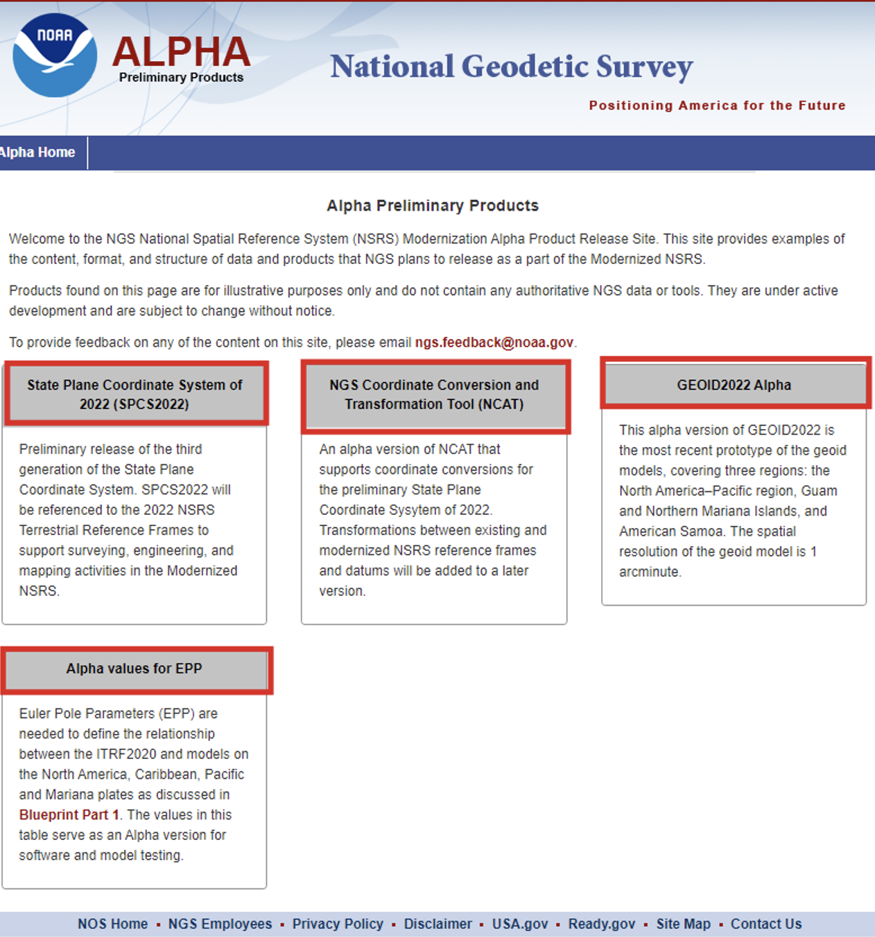
At the meeting, NGS highlighted some new products on its Alpha Preliminary Products site. The alpha site provides products that are useful for individuals who want to obtain a better understanding of the products that will be distributed as part of the new, modernized NSRS.
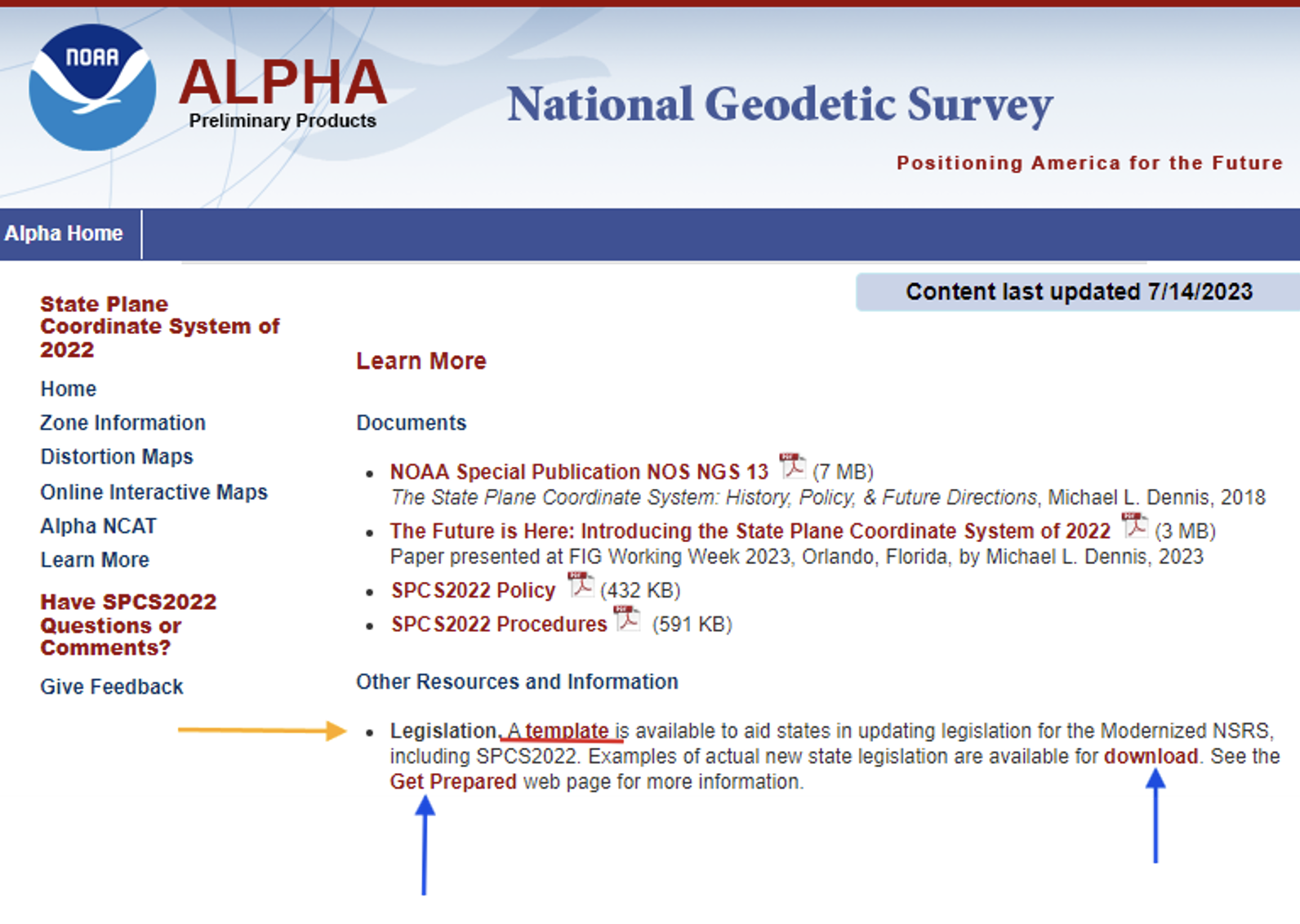
First, I want to bring attention to the importance of ensuring that the state’s legislation is modified or rewritten, if required, to include that the current horizontal and vertical datums are being replaced with the new, modernized NSRS. The “Learn More” button on the SPCS2022 Alpha site provides information about legislation.
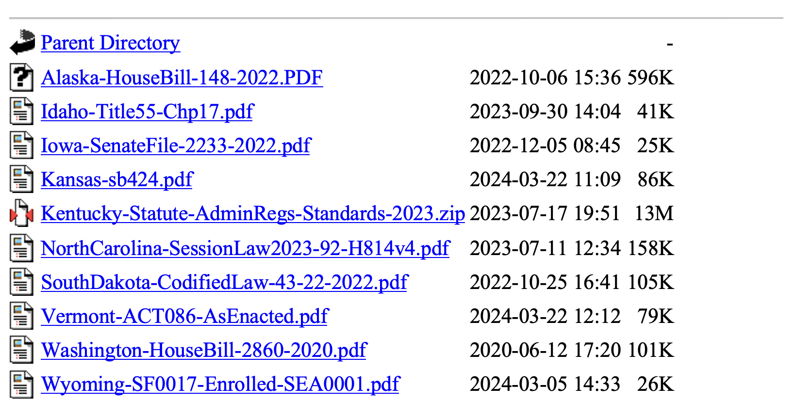
Per personal communication with Michael Dennis, Ph.D., NGS SPCS2022 Manager, as of June 26, 2024, the following 12 states have have enacted into law NSRS modernization: Alaska, Idaho, Iowa, Kansas, Kentucky, Louisiana, Nebraska, North Carolina, South Dakota, Vermont, Washington, and Wyoming.
Users can download examples of actual new state legislation here.
Examples of legislation.
During the joint AAGS/NSPS/NGS meeting, Tim Birch, the executive director of NSPS, said that anyone who has questions about updating legislation for the new, modernized NSRS, including SPCS2022, can contact him directly.NSPS has experience working with agencies and individuals to develop legislation as indicated in the following statement on the NSPS website.
“We are the voice of the professional surveying community in the US and its territories. Through its affiliation agreements with the respective state surveying societies, NSPS has a strong constituency base through which it communicates directly with lawmakers, agencies, & regulators at both the national and state level. NSPS monitors and comments on legislation, regulation, & policies that have potential impact on the activities of its members and their clients, and collaborates with a multitude of other organizations within the geospatial community on issues of mutual interest.”
As previously stated, the two latest alpha products are the “GEOID2022 Alpha” and “Alpha Values for EPP.” My December 2017 newsletter discussed GEOID 2022 and the North American-Pacific Geopotential Datum of 2022 (NAPGD2022), and my February 2022 newsletter discussed the Euler Pole Parameters process and use in the new, modernized NSRS.
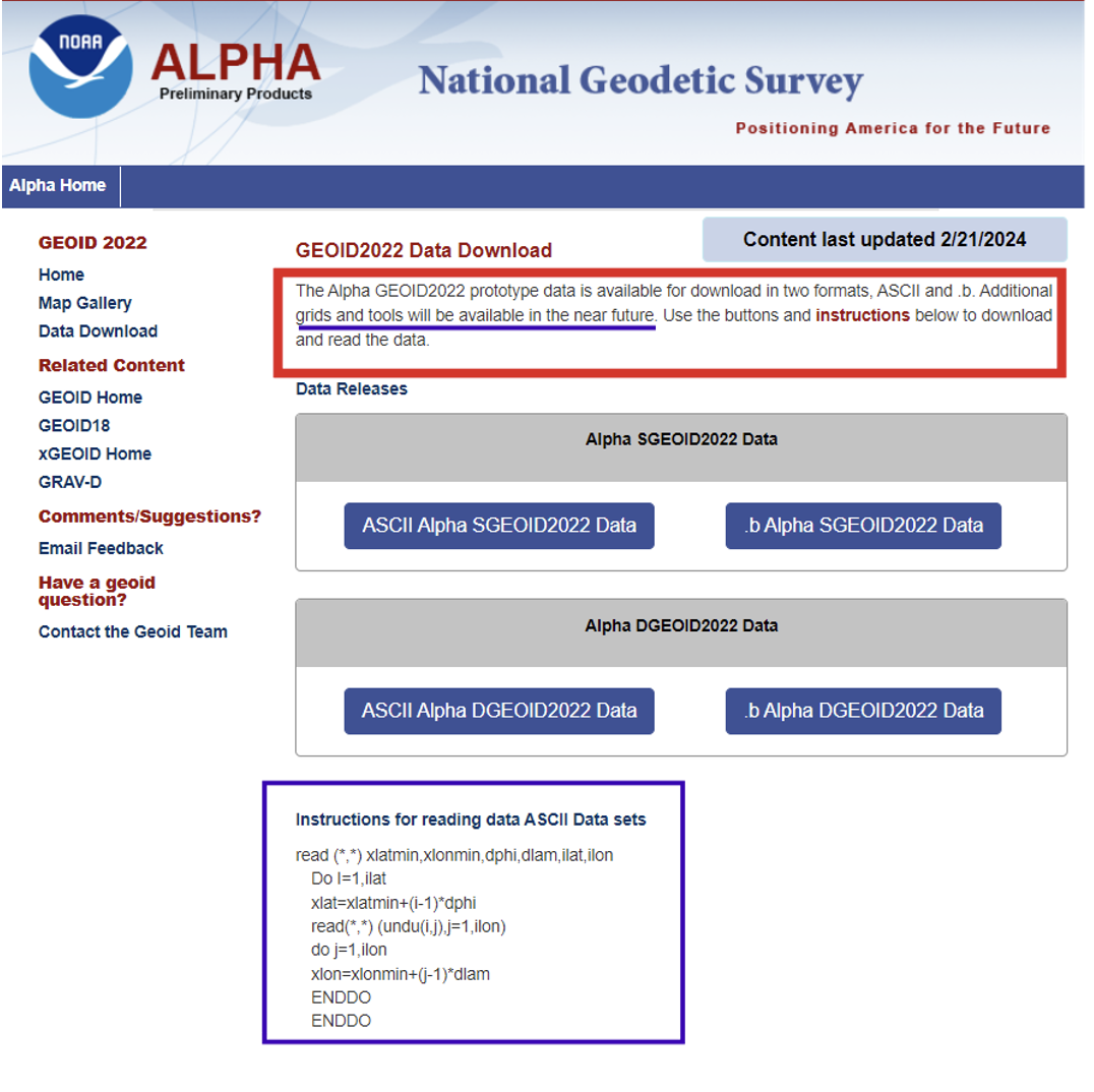
The GEOID2022 Alpha page provides a version of GEOID2022, which is the most recent prototype of the geoid models. The reference ellipsoid is Geodetic Reference System 1980 (GRS 80, but the geometric reference frame is ITRF2020). The Alpha GEOID2022 prototype data is available for download in two formats, “ASCII” and “.b.” There is a static component (SGEOID2022) and a dynamic component (DGEOID2022). These grids will be useful to programmers who want to develop and test their systems. Additional grids and tools will be available in the future.
Technical Details of the Alpha prototype of GEOID2022
GEOID2022 alpha is the last prototype of GEOID2022. It covers three regions: the North America–Pacific region, Guam and Northern Mariana Islands, and American Samoa. The spatial resolution of the geoid model is 1 arcminute. The geoid heights, which are in the tide-free system, are with respect to the reference ellipsoid of the Geodetic Reference System 1980 (GRS80) in the ITRF2020 geometric reference frame. GEOID2022 alpha includes static and dynamic components for the geoid heights. For detailed fundamental parameters of the geoid model, refer to NOAA Technical Report 78.
GEOID2022 Alpha
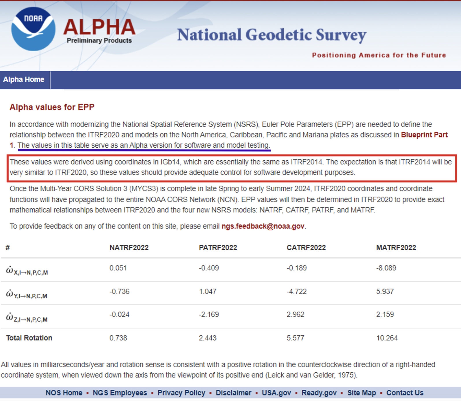
The Alpha EPP site provides the Euler Pole Parameters (EPP) that are needed to define the relationship between the ITRF2020 and models on the North America, Caribbean, Pacific and Mariana plates as discussed in NGS’s Blueprint Part 1 document.
Alpha Values for EPP
As stated in Blueprint Part 1, NGS will define the official relationship between ITRF2020 and the four NSRS TRFs through equation 59, using the rotation matrix in equation 58 resulting in equation 60.
I programmed this using a simple Excel spreadsheet to compute some of the potential changes between epochs for North Carolina. They were very similar to the ones that I depicted in my February 2022 newsletter that discussed the Euler Pole Parameters process and provided plots depicting the movement.
I would like to highlight the latest information available on the State Plane Coordinate System of 2022 alpha site. As previously stated, in about a year, the new, modernized NSRS will be available as a beta product. Users must get prepared by accessing NGS’s alpha products as well as taking the opportunity to provide feedback to NGS to improve their products and services. The Online Interactive Maps page provides information about the zones for every U.S. state and territory.
Clicking on the Online Interactive Maps link opens a NOAA ArcGIS online website that provides information about the Alpha State Plane Coordinate System 2022 preliminary zone designs. I have highlighted a few items that may be of interest to users.
The site provides a description of the site, links to various types of zones, links to data sources and information about distortion.
SPCS2022 online interactive maps.
Clicking on the link for zone definitions provides a list of zones and their parameters. This same information is also provided when users click on a zone on the map. I will demonstrate this later in this newsletter.
Per personal communication with Dennis, as of June 26, 2024, seven states have some or all their SPCS2022 zone definitions formally finalized, consisting of 205 out of the 965 zones (the total number of zones is still preliminary):
Alaska (partial coverage multizone layer)
Arizona (both multizone layers)
Idaho (both multizone and statewide)
Kentucky (both multizone and statewide)
North Carolina (statewide zone; it has no other zones)
South Dakota (both multizone and statewide)
Wisconsin (multizone)
Dennis informed me that the information on the alpha SPCS2022 Experience has been updated. He told me that the total number of zones decreased from 967 to 965, but based on coordination with the International Association of Oil & Gas Producers (IOGP) Geodesy Subcommittee the number may eventually increase to 972 (more about that in a future newsletter).
He stated that his goal is to finalize the zone definitions by the end of this calendar year or early 2025. Users should keep checking the alpha site.
Dennis mentioned that the website now offers a new feature that provides the distortion value when users click on the map. A nice thing about that is the site can be used on a smartphone, allowing users to obtain real-time distortion information from their location.
Clicking on the link titled “View” in the upper right corner of the box brings up a map that depicts the SPCS2022 zones.
View of ALPHA (preliminary) SPCS2022 zone designs.
When you click on the note about the ALPHA being preliminary, the map underneath appears where the user can select the type of maps they wish to review.
The following options are available: All Zone Layers, Statewide Zone Layers, Multizone Complete Layers, Multizone Partial Layers, and Special Use Zone Layers.
Users can use their mouses or the “+” button on the left-hand side” to zoom to a particular region, or use the search button on the right-hand side to select a State or zone.
Using the search box.
Information about a particular zone pops up by clicking on a point on the map.
Detailed information provided for a zone.
Each zone provides links to other features based on the location of the point selected on the map.
The image below provides the distortion in ppm for the point selected on the map.
The Alpha NCAT site can be used to obtain an estimate of the changes between SPCS83 and SPCS2022. It should be noted that all values will be in meters (m) and international feet (ft).
International feet may be new to some surveyors who were previously using the U.S. survey feet in SPCS83. The U.S. survey foot will not be used with the NSRS, including SPCS2022 coordinates. NGS and the National Institute of Standards and Technology (NIST) have taken action to deprecate the U.S. survey foot. What does that mean?. NIST has the following statement on its website: “Beginning on January 1, 2023, the U.S. survey foot should be avoided, except for historic and legacy applications, and has been superseded by the international foot.” This means that NGS will not be publishing SPCS2022 in U.S. survey feet but all historic products and services such as SPCS83 will still be provided in U.S. survey feet (sft) and international feet (ift).
More information and resources about the deprecation of the sft are listed below (personal communication from Dennis):
The official announcement is the final determinationFederal Register Notice (FRN) on deprecation of the sft issued on 10/5/2020. It was jointly issued by the National Institute of Standards and Technology (NIST) and NGS. I encourage everyone concerned about this topic to read it closely and in its entirety; it can likely answer most questions. The FRN includes information on the continued use of sft for legacy applications (such as SPCS 83). That is stated in the last paragraph of the “Notice of Final Determination” section; in items #1 and #2 in the “Counterpoints to Feedback Expressing Opposition”section; and in the second paragraph of the “Implementation Summary and Actions” section.
The legacy issue is also addressed in the 10th FAQon the NIST website and in the 11th FAQon our “new datums” FAQs web page.
The 40 states that officially adopted the sft for SPCS 83 are listed in Table C.1 of Appendix C of NOAA Special Publication NOS NGS 13, “The State Plane Coordinate System History, Policy, and Future Directions.”
Although the final determination FRN is itself not a law, Congress has passed several laws giving NIST the authority to maintain national standards of measurement. These and other related federal laws are given in the initial sft FRNissued on 10/17/2019.
An NGS webinar given on 11/10/2022 addresses the deprecation of the sft in the context of state plane. Two previous NGS webinars also provide additional background and historical information on the sft, one given on 4/25/2019 and the other on 12/12/2019.
Input to Alpha NCAT.Photo:Output from Alpha NCAT.
This newsletter highlighted the products on NGS’s Alpha Preliminary Products site. The alpha site provides products that can be useful for individuals to obtain a better understanding of the products that will be distributed as part of the new, modernized National Spatial Reference System (NSRS). NGS is providing these products on an alpha site so that they can get feedback from users. I would encourage all users to access the alpha sites and provide comments to NGS so that their products and services better meet the needs of the surveying and mapping community.
Welcome to the NGS National Spatial Reference System (NSRS) Modernization Alpha Product Release Site. This site provides examples of the content, format, and structure of data and products that NGS plans to release as a part of the Modernized NSRS.
Products found on this page are for illustrative purposes only and do not contain any authoritative NGS data or tools. They are under active development and are subject to change without notice.
To provide feedback on any of the content on this site, please email [email protected].
GPS vulnerabilities have been widely reported in the press. What steps have been taken to back up GPS use in U.S. critical infrastructure?
Jules McNeff
“President Biden on April 30 issued a National Security Memorandum on Critical Infrastructure Security and Resilience. GPS plays a vital role in the operation of critical infrastructure, and some sectors are considering their own backups. Other than conducting studies and meetings to admire the problem, the federal government has done virtually nothing to provide a comprehensive answer. In fact, the government is now dismantling the Loran system, though enhanced Loran (eLoran) is a viable and affordable GPS backup, specifically recommended for use by prior U.S. Department of Defense and U.S. Department of Homeland Security Deputy Secretaries. Given the vital role PNT and GPS play, it’s a mystery why such a viable solution is simply ignored.”
— Jules McNeff Overlook System Technologies
Will GPS remain the Gold Standard of space-based PNT services for the foreseeable future?
“GPS led the emergence and growth of a global space-based PNT service enterprise and has been the Gold Standard since its inception. The U.S. Department of Defense and Air Force (now Space Force) have maintained that standard through stable, transparent, and consistent policies and continuous performance improvements for the services it provides to all users. Now, in the face of foreign competition, hostile threats, budgetary pressures, reorganizations and management fragmentation, dilution of corporate memory, and inconsistent leadership support, those policy and performance foundations are in danger of eroding. The outcome for GPS and its future in the global PNT Enterprise is purely in the hands of our federal leadership today.”
Some people may have anticipated that the unmanned aircraft industry, amid initial exuberance over the new technology and the impact it has made, would eventually suffer some sort of implosion. Nevertheless, while some smaller players have come and gone, by and large new companies are still sprouting, and other start-ups may have been absorbed by bigger fish with more resources.
DroneDeploy acquired a couple of software image acquisition and robotics companies in recent years – both StructionSite (2022 acquisition, San Francisco) and Rocus (2021 acquisition, New Zealand) are now part of DroneDeploy, widening their jointly addressable markets.
Drone Delivery Canada (DDC) is in the process of merging with Volatus to bring a combined service and equipment capability to market. Both companies are currently listed on the Toronto Stock Exchange and will trade under DDC’s stock symbol “FLT” following the completion of the merger, anticipated by the end of Q3 2024. DDC provides a unique Condor cargo UAV capability, remote operations center, cargo infrastructure and operations software, while Volatus provides UAV services, training and equipment sales to enable a path to market for the combined company.
Condor UAVs can carry approximately 400lb of cargo. (Photo: DDC)
Joby has been a leading participant in the emerging eVTOL air-taxi market segment, and acquired radar developer Inras GmbH in Linz, Austria in December 2021. The small Inras team brought advanced radar technology to Joby’s eVTOL development to provide onboard sensing and navigation.
Now Joby has also acquired the autonomy division of Xwing, which brings, according to the Joby website, “autonomy, including vision system processing, detect and avoid algorithms, mission management and decision making, ground control stations, remote operations and also the integration of Artificial Intelligence (AI) and machine learning algorithms.”
Joby’s two flying pre-production eVTOL aircraft (Photo: Joby)
The Xwing Superpilot software has previously enabled autonomous ‘gate-to-gate’ flight, 250 self-contained flights and 500 auto-landings with a Cessna 208B Grand Caravan for demonstration/tests. This system resulted in an official project designation for the certification of a large unmanned aircraft system (UAS) by the Federal Aviation Administration (FAA) in April 2023, and an Air Force Military Flight Release in 2024. Joby expects the acquisition to not only further long-term autonomous civilian capability — initial FAA certification is anticipated with piloted aircraft — but also to support existing and future business with the United States Department of Defense (DOD).
Meanwhile, Airbus is taking a similar approach by teaming with Helsing in Europe to integrate AI into a future Airbus unmanned Wingman concept aircraft — a UAV designed to fly with and be controlled by front-line manned fighter aircraft. Alongside growing European force requirements, Airbus envisages a lower-cost, attributable, UAV commanded by manned aircraft that could dispatch the Wingman for target reconnaissance and destruction or electronic jamming and deception of enemy air defense systems.
Airbus and Helsing CEOs with Wingman model.(Photo: Airbus)
Both Joby and its rival Archer have also received FAA Part 135 certification, which allows them both to run an air-taxi operation. Neither has yet obtained FAA authorization for their eVTOL aircraft, but both appear to have a clear mandate from the FAA for the steps necessary for those certifications. Both intend to operate existing certified fixed-wing aircraft as air taxis in the meantime under the Part 135 authorization.
While browsing through the FAA’s Special Class Airworthiness Criteria for the Joby Aero Model JAS4-1 Powered-Lift, published on the Federal Register, I learned that the task to certify a brand-new category of aircraft is huge — not big, absolutely gigantic.
FAA put together a draft of proposed cert criteria and put it out for comments to interested government agencies and industry — a whole slew of comments were received, which the FAA reviewed. The FAA incorporated some and discarded others. Just the response to these comments goes on for many pages — there were a lot of comments. Nevertheless, just skimming through FAA’s responses to these comments was a significant undertaking, never mind reviewing and understanding the basic requirements for, say, the two-performance option. Imagine what eVTOL operators have to go through to demonstrate that they meet the steps to achieve FAA certification.
The cert basis for Joby appears to be a combination of fixed wing and helicopter requirements, plus more to address the novel electrical propulsion system and the batteries that provide its power. Two levels of performance standards are set out — an “essential” level and an “increased” level. The 42 organizations that commented on the draft requirements included worldwide aviation agencies, eVTOL and aircraft companies, industry associations and major components suppliers, the Association for Uncrewed Vehicle Systems International (AUVSI) and some individuals — a huge group of involved and impacted organizations.
Joby applied to the FAA in November 2018 for certification of its Model JAS4-1 powered-lift eVTOL. Joby has been supporting just the activity related to certification for six years to date. All the other eVTOL developers are at a very similar stage as they try to get their aircraft into service carrying people and generating income.
Most eVTOL developers have major sponsors familiar with the certification process. Otherwise, the effort would just be too costly, never mind the cost of proving the capability to operating customers, the country as a whole and capturing the imagination of intended users. Plus, of course, building and qualifying the test vehicles, and the operational infrastructure to allow these eVTOLs to land, pick up customers and fly them to somewhere near their destination. The length of time to do this over so many years has broken many unwitting start-up companies. Achieving this goal can be incredibly difficult without the substantial financial resources of major companies such as Airbus, Boeing, or major airlines.
Moving from UAV to passenger airplane is something not to be taken lightly. As a potential future passenger, just keep waiting for your first flight in an operational certified eVTOL. Several of the contenders have targeted 2026, but who knows? I wish them the best of fortune and they’ll need it!
The solar storm in May that produced a beautiful aurora borealis as far south as Mallorca, Spain, also stopped GNSS-based precision agriculture for a couple of days. The same month, articles in major U.S. newspapers detailed aspects of a growing confrontation between the United States, Russia and China —vying for dominance in near-Earth space, now part of the military fighting domain — that could lead to far greater disruption. Nearly all satellites are highly vulnerable to cyberattacks, ground- or space-based lasers, high-powered microwaves, the debris field from a destroyed satellite and the radiation produced by a nuclear explosion in space. The last one would disable by far the greatest number of satellites because of its range and because commercial satellites, which constitute more than 90 percent of all satellites in orbit, are not hardened against such radiation.
Luccio
A May 16 article in The Wall Street Journal titled “Russia Launched Research Spacecraft for Antisatellite Nuclear Weapon Two Years Ago, U.S. Officials Say,” reported that in February 2022, shortly before it invaded Ukraine, Russia launched Cosmos-2553, “designed to test components for a potential antisatellite weapon that would carry a nuclear device.” It linked the launch to a continuing Russian nuclear antisatellite program and said that, if deployed, the weapon “would give Moscow the ability to destroy hundreds of satellites in low-Earth orbit (LEO) with a nuclear blast.”
“The Pentagon,” the article pointed out, “has become increasingly reliant on commercial satellites.” In LEO, it reported, there are almost 6,700 U.S. satellites, while China has 780 and Russia only 149. Therefore, the Russians would have a lot less to lose should they choose to explode a nuclear weapon in LEO.
A May 17 article in The New York Times was titled “New Star Wars Plan: Pentagon Rushes to Counter Threats in Orbit.” The subhead read: “Citing rapid advances by China and Russia, the United States is building an extensive capacity to fight battles in space.” It said that, in a major shift in military operations, the Defense Department “is looking to acquire a new generation of ground- and space-based tools that will allow it to defend its satellite network from attack and, if necessary, to disrupt or disable enemy spacecraft in orbit.” Meanwhile, “both Russia and China have already tested or deployed systems such as ground-based high-energy lasers, antisatellite missiles or maneuverable satellites that could be used to disrupt [U.S.] space assets.”
The decision to strengthen U.S. warfighting capacity in space, it said, is driven mostly by China’s expanding fleet of military tools in space, which threatens to prevent U.S. Navy operations in the Western Pacific. “The Pentagon is separately working to launch a new generation of military satellites that can maneuver, be refueled while in space or have robotic arms that could reach out and grab — and potentially disrupt — an enemy satellite.”
These are all reasons to quickly develop and deploy a wide mix of complementary PNT solutions that would lessen reliance on GNSS satellites and, therefore, make them less of a target.
Point cloud and 360-degree image collected with the Leica Pegasus: Two Ultimate. (Photo: Leica Geosystems )
The latest mobile mapping innovations are transforming how we manage, design and monitor our critical infrastructure — in particular, reshaping road maintenance. Through the advance of mobile mapping and reality capture imagery, our ability to map, proactively survey and even design roads, from simulating the vibration of a vehicle on a road to mapping out city routes, is drastically improving through the symbiosis of the digital and physical worlds.
Leveraging data: Traditional vs autonomous mapping
Traditional methods for assessing damage to road surfaces are highly manual, field-based, labor-intensive and time-consuming. Visual inspection, for example, comes with resourcing challenges, data exhaustivity and inaccurate assessments, making quality assessment and control a challenge. There is limited accurate analysis of how the road changes over time, and the work involves significant safety issues, with surveyors required to work in the field near live traffic and often requiring the traffic to be interrupted to allow measurements to be taken.
By contrast, automated laser scanning solutions provide spatial geometry for precise measurements that imagery-only methods cannot capture when assessing damage to road surfaces. They overcome any inaccuracies or lack of detail regarding location and circumstances. This technology also allows professionals to study the surrounding context of the road and measure the depth of a hole or the size of a crack with spatial data, which visual methods cannot capture. Hexagon’s mobile mapping systems, used for virtual road management and maintenance, enable access to a completely virtual environment to unlock the insights this data provides, transforming how we manage our infrastructures. With spatial data collected over time, asset degradation and other factors foundational to maintaining road infrastructure can be predicted by the more effective leveraging of data.
With geospatial data allowing the accurate mapping of potholes, rutting and depressions alongside accurate location mapping using GIS, asset managers can map the data onto real-world imagery to create an interactive, 3D model integrating the physical world and geospatial data. Combined, this unlocks insights and overhauls efficiency for asset managers performing road maintenance, allowing them to prioritize and make decisions based on data live in the field.
Veris deploys Hexagon’s solutions for road mapping
Recently, Hexagon’s technology was used by Veris, a provider of spatial data services to deliver end-to-end solutions for road management and maintenance in Australia. It combined a Leica Geosystems mobile mapping system, the Leica Pegasus:Two Ultimate, with Hexagon M.App Enterprise to create a high-quality, configurable solution and designed its own bespoke software platform RoadSiDe.
Veris used the mobile mapping system on the Hume and Melba Highways to identify and assess road defects and ground penetrating radar (GPR) to rapidly perform data capture of the road corridor. Then, RoadSiDe analytics and machine learning enabled the delivery of the data and insights using M.App Enterprise and Luciad Fusion, integrating 3D visualizations and 2D dashboards to identify, assess and quantify the road condition as part of the only full 3D road condition and corridor platform. The in-house solution for scripts and automation Veris developed made it simple for their clients to visualize and interact with the data, providing analytics and value-added services on demand that offered valuable insights for its clients.
As part of the surface defects workflow they use for analysis, Veris takes the raw point cloud data and compares it with the ideal road exterior to create a surface difference model, followed by contours and improved defect definition. This cross-comparison and integration allows them to use and visualize the data they acquired by precisely measuring the gaps and holes. Veris efficiently captured road cracking in detail with its additional 12MP/20MP camera system. These are then mapped into the RoadSiDe dashboard, and cracking width and length are captured within the geodatabase. Machine learning is used to detect cracks in the road surface before pixels are classified into clusters and projected onto the original images for verification and quality assurance. This can then be integrated with location coordinates, allowing clients to see precisely where each cracking is located. With this georeferenced data digitized and visualized, Veris can leverage as much of its data as possible into the most effective platform for its users.
Expanding the scope of mobile mapping
The data captured by mobile mapping solutions is just as helpful in designing roads as in maintaining them and can be incorporated into the construction of future roads and city planning. The data even can be used to simulate, for example, the movement of a heavy truck through city streets to examine whether it will impact potholes or damage any road signs, allowing asset managers to predict and prevent damage and maintain road infrastructure for years to come.
Photo: richard johnson / iStock / Getty Images Plus / Getty Images
GNSS technology has become integral to construction work. In particular, firms rely on GNSS signals in four critical areas.
Site surveys
Surveying always has been a foundational aspect of construction planning. Mapping and staking the construction site is essential in preparing to break ground and build on site. Surveyors begin the task of bringing engineering plans from vision to reality.
This work may take place from the air and on the ground, and it now typically involves a vast array of tools to ensure accuracy, including drones, cameras, lasers, sensors, and GNSS signals. The data from GNSS are critical in helping surveyors and engineers create “digital twins” — virtual representations of the physical site they can update in real time to ensure the site matches the plan.
Robotics
Robotics have further transformed the work of construction, both in terms of site surveying and the work of building. Rovers, drones and construction robots can execute various tasks to improve project efficiency and save money.
Once again, GNSS signals play a critical role in ensuring robots carry out their tasks effectively and accurately. Land surveying rovers, for instance, rely on real-time satellite data to navigate construction sites and mark spots for construction with pinpoint precision.
Damage prevention
Construction work is highly invasive, penetrating the ground where hidden power, gas and water lines lie. Misfires during this process can have substantial cost implications or even be life-threatening for construction crews.
Construction firms can use GNSS receivers and other complex instruments to prepare for excavation. These tools provide detailed location information for underground pipes and wires and ensure contractors don’t damage critical underground infrastructure and cause costly delays or dangerous work conditions.
Engineers also can use GNSS data to pinpoint where future utility lines will be, ensuring construction does not get in the way of laying pipelines to bring the constructed building online.
Site inspections
GNSS data continue to play a critical role while construction work unfolds. As builders lay foundations, frame buildings and add finishes, engineers and inspectors can collect site reports and use satellite data to update digital twins and verify the work is on track.
With updated and accurate digital twins, planners have a real-time view of the work in progress, which they can use to inform plans, budgets and timelines as the project unfolds.
My past GPS World newsletters (February 2024, March 2024, April 2024 and May 2024) highlighted the NGS Geospatial Modeling grantees which included creating a CORS Dashboard that will be very useful to NGS employees monitoring the CORSs and evaluating the Intra-Frame Deformation Model (IFDM).
I mentioned in the May 2024 newsletter that NGS announced the release of a beta version of a new NOAA CORS Network (NCN) Station Web Page. Each CORS station in the NCN will have its own page with data, metadata, maps and photos displayed in a modular layout so information is easily found in one location. This newsletter will describe some features of the new beta site.
I will highlight some of the information provided by the routine, but I would encourage others to access the beta site and provide feedback to NGS. NGS states on the site that “This is a Beta product. We are interested in your feedback. Please email us at: [email protected] and indicate the subject as “NCN Station Pages Feedback.”
When you access the website, it defaults to the CORS station GODE. The user has the option to enter their own CORS station in the box located on the right-hand side of the webpage.
Texas CORS Station TXLV.
A nice feature of the site is that the CORS data availability for the last seven days is provided under the Station Information section. For those interested in downloading data, there is a button titled “Quick Data Download,” on the top left corner. The site allows users to download daily data from the past 30, seven or two days.
In my example, I downloaded the last seven days of data for CORS TXLV. It only took a few seconds to download and provide the data in a zipped file. If a user includes this process in their standard operating procedure, they can easily download all the CORS data required for their project.
Downloading TXLV GNSS data.
Another planning tool available is the weather information for a week. Today, most users can get the weather information on their phone. However, this is a convenient option to have when you are looking at available CORS on the day of occupying marks. It can help in managing schedule changes.
There is an option to show the five nearest CORS relative to your selected CORS by clicking on the button titled “Show Closest 5 on Map.”
CORS Located near TXLV.
Clicking on the button labeled “Show Legend” provides information about the CORS depicted on the map. This is a useful feature especially if selecting CORS that provide GNSS data other than GPS and/or data at different sampling rates.
If a user clicks on the button “Open NGS Map,” the site will access the NGS Map website and provide information about the selected CORS. This allows users to get information about the CORS. I found that the beta site provided most of the same information using the various options on the NGS Map website.
NGS Map depicting CORS TXLV.
The site provides photos and equipment history that may help in troubleshooting an issue associated with processing sessions or during the analysis of the adjustment results. I have highlighted that a new antenna was installed at the TXLV CORS on August 5, 2021. I will explain later in this newsletter how this information helped me during my analysis of a GNSS project.
Photos and equipment history of TXLV.
Under the Coordinates and Velocities section, the site provides information about the latest coordinates and velocities along with superseded values for the selected CORS. The superseded values may not be of interest to most users, but I am always looking at the changes in CORS coordinates. It is my nature to try to understand the reason why something has changed; especially for CORS that I am including in a GNSS project.
Coordinates and velocities.
Clicking on the link titled “Position and Velocity” under the Coordinates and Velocities section provides the coordinate and velocity information for your selected CORS. I have highlighted the ITRF2014 velocities, the NAD 83 (2011) velocities, the latest antenna type, installation date and the dates the positions and velocities were revised.
As shown in the image above, the position and velocity sheet provide the dates that the position was revised. Clicking on the link titled “Datasheet with GRP/MON included (if available)” in the Coordinates and Velocities section provides the datasheet that lists the NAD 83 (2011) superseded survey control values. The superseded ellipsoid heights from the datasheet are provided in the box titled “Excerpt from TXLV Datasheet.”
When you are trying to estimate heights to the 2 cm level, changes in published NAD 83 (2011) CORS heights at the 2 cm level are significant and should be investigated and understood. This beta CORS website offers useful information that can help understand some of these changes. I will explain later in the newsletter how this information and other data from the beta site helped me in the analysis of my GNSS project.
Excerpt from TXLV data sheet.
The beta site provides plots that depict the daily positions and residuals for a CORS. In my May 2024 newsletter, I stated that NGS has developed a Beta CORS Time Series Tool that provides information that assists users in selecting appropriate CORS for a project. The Beta CORS Time Series Tool provides the residual differences from the daily NGS OPUS-NET solutions with the coordinates from the official CORS’ coordinate functions. The excerpt below explains the plots and residuals:
This tool computes and displays the residuals for up to 50 CORS stations within the NCN. The mean, standard deviation, and root-mean-square error of the residuals are also provided in a summary table that is available for download. This tool is informational, not authoritative.
The residuals are calculated as the difference between the daily observation at a station and the official daily coordinates for a station. The daily observation is processed from the GPS L1 and L2 signals only, using a network adjustment program. There must be a minimum of 8 hours of data present in a 24 hour file for a solution to be generated. The network adjustment program is an internal application developed by NGS for monitoring the position of the CORS stations in the NCN (Gillins et al., 2019). The official daily coordinates for a station are calculated using the reference epoch (2010.0) position and velocity published as the station coordinate function in the Position and Velocity File. An example of a Position and Velocity File for NCN station GODE can be found here. To obtain Position and Velocity Files for NCN stations please visit the NCN Station Pages and navigate to the Coordinates and Velocities section.
This tool is optimized for plotting data extending between 30 to 90 days in length but can be customized to other time frames. The earliest start date currently available is October 27, 2018, which is the completion date of the MYCS2 and the end date can be as recent as 3 days before the present day. This three-day time lag is so that the final orbits can be used in the network adjustment to create the daily solutions. Then, please enter the 4-character station ID for at least one and up to 50 CORS stations in the NCN and submit this request to obtain a map, summary table of comparative statistics, and residual plots during the date range.
The beta NGS NCN station pages show similar plots to the Beta CORS Time Series Tool. the station pages also allow users to create position and residual plots at different periods. I find these plots very useful when selecting CORS to be included in a GNSS project. The latest plots are of interest to users when selecting CORS to be included in their GNSS project but there are reasons to look at plots depicting older time periods.
Position and residual plots for TXLV.
I previously mentioned that the antenna of CORS TXLV was changed on August 5, 2021, so I used the option to plot the last five years to include data before and after the date the antenna was changed. I highlighted August 7, 2021, on both plots. This was two days after the antenna was changed on CORS TXLV.
There appears to be a 2 cm upward shift in the up component after the new antenna was installed. There was also a change of about 1 cm in the north component. Something else to notice in the position plot is that the east component has a significant tilt during the five years. The below provides the ITRF2014 velocities — the eastward component velocity is —1.21 cm/year. In 5 years, one could expect to see about a 6 cm change.
Position and residual plots for TXLV.Five-year position plot of TXLV.Five-year residual plot of TXLV.Position plot of TXLV for selected time interval.
These small changes affected my analysis and network adjustment results. During the past several years, I have participated in several Harris-Galveston Subsidence District (HGSD) GNSS projects performed in the Houston-Galveston, Texas, region. I have been involved with estimating subsidence in the Houston-Galveston, Texas, region for about 40 years so when I see changes in height values indicating an apparent uplift it makes me question my results. Therefore, I started investigating the CORS involved in the GNSS project. I looked at the Texas CORS surrounding the GNSS project: WHARTON CORS, COLUMBUS CORS, HEMPSTEAD CORS, LIVINGSTON CORS, and LIBERTY CORS.
The table below provides the differences between the published ellipsoid height and the previous superseded height for the five CORS. As the table indicates, the published ellipsoid height of the CORS increased by about 2 cm from the superseded height. This led me to use the NGS NCN Station Pages to investigate these CORSs. I found that all five of these CORSs had new antennas installed in 2021 and their position plots depicted a similar shift.
I want to emphasis that I am not saying that anyone did anything wrong or incorrect. The CORS manager of these sites provided the appropriate metadata to the NGS CORS team so the site information could be updated and correctly reported. What this indicates to me is that the installation of the new antenna and setup may have affected the height component of these CORS, that is, it may have changed the official position of the monument’s reference point. Again, I want to emphasize that I am not saying that anyone did anything wrong or incorrect. NGS’s process includes monitoring all CORS that are part of the NOAA CORS Network (NCN). The NGS CORS Team noticed the significant change in the up component comparing it to its expected value, so they computed a new coordinate and published the new coordinate in 2022. In my opinion, anyone using these CORSs as constraints in their GNSS projects after the date that the new antenna was installed and before the new coordinate was published could have generated adjusted heights that are in error by 2 cm. As previously stated, when you are estimating heights to the 2 cm level, changes in published NAD 83 (2011) CORS heights at the 2 cm level are significant. In my opinion, this type of analysis should be performed by all users that are incorporating CORS in their GNSS processing.
CORS ID
PID
Station Name
Published Ellipsoid Height (m)
Published Date
Date the New Antenna was Installed
Date Station Coordinates Superseded
Superseded Ellipsoid height (m)
Difference Between Published and Superseded Heights (cm)
txwh
DL9086
WHARTON
8.615
04/22
4/28/2021
06/19
8.595
2.0
txcm
DL9812
COLUMBUS
45.481
04/22
3/17/2021
06/19
45.459
2.2
txhe
DH3608
HEMPSTEAD
48.823
04/22
5/06/2021
06/19
48.803
2.0
txlv
DN4508
LIVINGSTON
29.100
04/22
8/05/2021
06/19
29.075
2.5
txli
DH3612
LIBERTY
-9.782
02/22
5/06/2021
06/19
-9.802
2.0
Keep checking NGS beta site because NGS makes changes based on user feedback. As I previously stated, I would encourage everyone to access the beta site and provide your feedback to NGS. NGS states on the site that “This is a Beta product. We are interested in your feedback. Please email us at: [email protected] and indicate the subject as “NCN Station Pages Feedback.” I have talked to the CORS team and they really would like feedback. The team will make changes to the website based on feedback from users.
How can commercial space help bridge the GPS vulnerability gap by providing alternative PNT services?
“With the proliferation of commercial SATCOM services being launched to provide global broadband services, there is an opportunity to leverage these capabilities to also augment positioning, navigation and timing (PNT). The Defense Science Board has been directed to consider this and is evaluating how these commercial alternatives, such as PNT signals-as-a-service, could supplement GPS if technical and logistical challenges could be overcome.
With the recent announcement of Iridium buying out Satelles for $115M and the apparent interest in the U.S. Department of Defense (DOD) to consider using commercial alternatives to provide backup PNT, this is likely to spur other innovations in this space and bring more players (and investors) to the market. This has the potential to significantly increase PNT resilience around the world by enabling the use of existing SATCOM services, with a wide diversity of spectrum allocations separated from GPS, allowing operation
in a GPS-denied environment.
Deployment also can be accelerated by leveraging commercial manufacturers of SATCOM equipment who can rapidly release commercial products with alternative embedded PNT capability that can provide aiding data through the Modular Open Systems Approach (MOSA) standards already developed for A-PNT devices in the DOD acquisition process.
The major barrier to adoption of these services, however, could be the anemic funding being provided for adoption of commercial space services to Space Systems Command’s new Commercial Space Office (COMSO).”
This month’s cover story focuses on jamming and spoofing in the military domain, but this is also a big challenge for users of civilian GNSS applications, such as airline pilots. Our July cover story will focus on complementary PNT — that is, non-GNSS sources of positioning, navigation and timing data that can complement GNSS and help make up for its inherent shortcomings, such as weak signals that are easily blocked by thick foliage and roofs, multipath and few satellites in view from natural and urban canyons.
Matteo Luccio
In the coming months, we will steadily increase our coverage of complementary PNT companies, products and services, including those based on low Earth-orbiting (LEO) satellites, because they are an increasingly important component of the PNT industry. We will start by expanding our coverage of this area on our website and in our digital newsletters, then increase coverage in our print editions.
One proposal that has received scant attention, including from this magazine, is to set up a ground-based, cryptographically protected GPS High Accuracy and Robustness Service (HARS) using the internet to distribute data already being produced by the U.S. government and government-sponsored organizations. This was the subject of a white paper released in May 2023 by the National Space-Based Positioning, Navigation, and Timing Advisory Board.
The paper argued that GPS is “falling behind” other GNSS because it relies on augmentation by third-party systems rather than providing such specialized advanced services itself, as BeiDou and Galileo do. While nearly all GNSS chips currently acquire first GPS signals, then those from other systems, deployment by BeiDou and Galileo of sub-meter accuracy services may lead chip manufacturers to reverse this order. If they do, the paper argued, it will cause the U.S. government to lose its strategic advantage in this area and put it in the same position that led the Chinese and European governments to launch their own GNSS programs.
The paper proposed a HARS that would remove satellite orbit and clock errors, ionospheric errors, and tropospheric errors and enhance the ability of GNSS receivers to operate in challenging conditions. This approach, the paper says, could allow Precise Point Positioning (PPP), authentication, and more. It would be “secure and less sensitive to radio noise and disruptions,” protect critical infrastructure, and enable new applications, such as “lane-dependent route guidance in automobile navigation and emergency vehicle guidance.” Additionally, by delivering, along with the corrections, cryptographically signed ephemeris on the same channel, the system would solve the problem of spoofed navigation data.
All of this could be done “without adding cost and complexity to GPS itself” resulting in “a world-class HARS at a small fraction of the cost or time, compared to implementing it on new GPS satellites.” The paper asked for funding for this new service and an agency to operate it, such as the U.S. Space Force or the federal Department of Transportation.
I thank John Betz, Ph.D., of MITRE, for bringing the PNT Advisory Board’s white paper on HARS to my attention. It can be found here.
The ongoing conflict between Hamas and Israel, along with the unrest in various universities across the United States in support of Gaza Palestinians, and the continued aggression by the Houthi rebels in Yemen against shipping, are impacting several aspects of our lives, including the rising cost of gasoline.
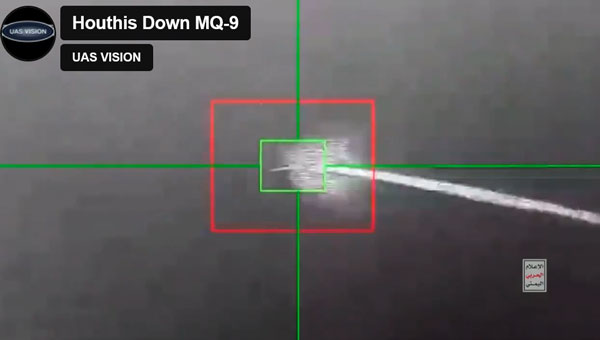
Since the United States began seeking out Houthi strongholds, it is now being reported that another MQ-9 Reaper drone has been shot down – making an apparent total of five such expensive U.S. UAVs lost over and around Yemen, according to US military reports.
Screenshot of a Houthi-released video of the downing of the MQ-9 Reaper drone (Photo: UAS Vision)
At $30 million each, compared to about $2 million for a surface-to-air missile, the Houthis are apparently ahead on cost. With a 50,000 ft ceiling, the Reaper is capable of avoiding short-range surface-to-air missiles. However, more visual or infra-red (IR) low-level detail may have been sought on this mission. In response, the U.S. military reported the downing of five Houthi UAVs over the Red Sea.
According to a Defense Intelligence Agency (DIA) report, Iran is supplying the Houthis with attack UAVs and longer-range missiles, which are often, if not always, re-assembled, repainted and re-named locally. The DIA said that one of the favorite Kamikaze UAVs used is the Iranian Shahed-136/Houthi Waid-2, which is reported to have a range of almost 1,600 miles. Neither side has yet acknowledged which drones were brought down by the United States.
However, around the same time, it was reported that perhaps two Houthi missiles hit the MV Andromeda Star oil tanker with reportedly little damage — no casualties were reported on the ship as it continued towards its destination Vadinar, India. Another ship, the MV Maisha, avoided a third missile. The missile landed nearby in the water, but the vessel put some distance between itself and the MV Andromeda, continuing safely.
The US/UK forces operating in the Red Sea have countered the more than 100 Houthi attacks on shipping with several airborne strikes on Houthi facilities. This renewed Houthi action over the weekend is thought to have been possible because they were restocked with weapons following the US/UK airstrikes, which slowed their attacks on shipping.
Hence the renewed threat to oil tanker traffic in the Red Sea has raised the already high threat level, and increased oil and gas prices at the pump are one of the consequences.
Meanwhile, Pakistan has bought 10 additional Chinese Caihong-4, which reportedly look and perform very similarly to the MQ-9 Reaper.
Caihong-4 looks very similar to the General Atomics MQ-9 Reaper (Photo: OE Data Integration Network (ODIN))
The CH-4 can be used for both attack and reconnaissance. It features a flight endurance of 30 to 40 hours, a range of 2,200 to 3,100 miles and can carry up to six weapons.
This brings Pakistan’s complement to 20 CH-4 UAVs. The new purchase may be to offset India’s purchase of 31 General Atomics MQ-9s, which is included in a huge, recently approved $3.99 billion weapons purchase from the United States. The two countries continue to feud over the contested Kashmir region.
AeroVironment (AV) has developed an add-on for fielded Puma class hand-launched reconnaissance UAVs, which brings autonomy and machine-learning to a worldwide, mostly military fleet of thousands of air vehicles. Referred to as the Autonomy Retrofit Kit (ARK), with AVACORE software, the new update allows operators to command and control one or more vehicles autonomously. This provides computer vision capabilities and enables connection to a distributed, mobile comms network to access data for several separated operating groups.
ARK retrofit kit for Puma 3AE and LE UAVs (Photo: AV)
According to AV, autonomous operating tasking is possible when communications are jammed and the UAV is then still able to execute its mission without manual input. Updated computer vision allows finding, classifying, positioning and daylight or nighttime tracking of objects such as people, vehicles, aircraft and ships. AVACORE includes several software interfaces for different autopilots, sensors and radios to provide integration flexibility.
A neat way to provide significantly enhanced capability for already fielded airborne vehicles when they have some downtime.
Finally, we have a short introduction to a new transport UAV being put together by a California company called MightyFly. The company is led by a woman who was highly instrumental in the success of the flight controls for the Zipline UAV, which is still blazing drone delivery trails overseas and now in North America — with more than one million deliveries. With advisory input from a retired FedEx exec, the team at MightyFly seems well on their way with both a Federal Aviation Administration (FAA) approved Part 135 application and a 20 mile ‘point-to-point’ flight corridor approval for test flights.
Cento gen 3 cargo drone (Photo: MightyFly)
The MF-100 prototype made its first flight and demonstration delivery in April 2021, while the third-generation Cento flew for the first time in December 2022. Cento has a 6’ x 1’ x 1’ cargo hold that can accommodate 96 small USPS packages, weighing up to 100lb and Cento and later models are expected to have a range of 600 miles at up to 150 mph. While their UAVs are currently all-electric, the plan is to add a gas/rotary engine to charge batteries to achieve this forecast range for the drone.
MightyFly has significant support from the U.S. Air Force Agility Prime program and the Air Mobility Command, who continue to invest in autonomous cargo developments as an alternative to leasing helicopters to transport parts, medical supplies and more. MightyFly came up with an auto-loading capability, which resolves the issue of a potentially changing weight and balance of a last-mile cargo drone.