Category: Opinions

  • Directions 2014: Great Expectations

    Directions 2014: Great Expectations

    Peter Large
    Peter Large

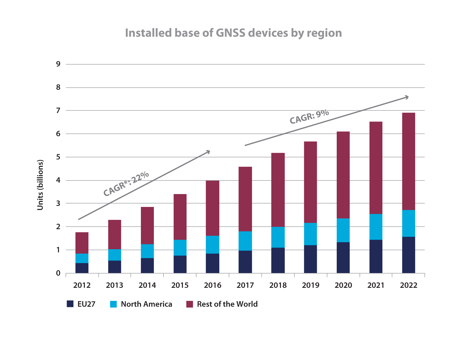
    By Peter O. Large, Vice President, Trimble

    November 29, 2013, marks the 210th anniversary of the birth of Christian Doppler. His work laid down the fundamental concepts that enabled researchers at Johns Hopkins University in the United States to make observations on the signals of Sputnik I during the International Geophysical Year of 1957. From those observations more than 60 years ago, we can trace the development of GNSS as we know it today. The very genesis of GNSS drew on the combined science, technology, and innovation from Europe, the United States, and Russia. Today, GNSS is a truly global technology that has changed for the better the lives of an estimated one billion people.

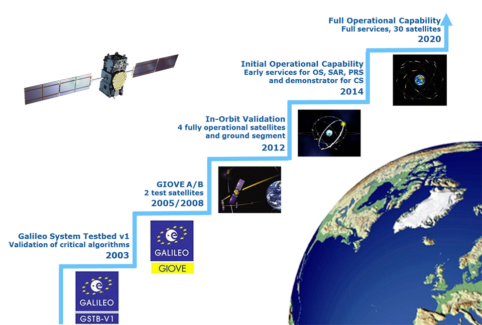
    2013 also saw a major milestone in the global history of GNSS with the announcement by the European Space Agency (ESA) that the Galileo system had generated its first position fix using operational space vehicles. Here at Trimble we have for some time been providing user equipment that is ready for the modernized, multiple-constellation environment emerging in the coming years. It is still exciting to see the plans of the GNSS operators gradually become a reality, whether it is the ongoing deployment of Galileo and BeiDou or the modernization of GPS and GLONASS. There is no doubt that GNSS users worldwide will benefit significantly from these new developments, and it is natural to expect that we will see continued user-driven adoption and integration of these systems in the year ahead, together with new applications and services that make full use of the expanding GNSS capabilities.

    Global Addiction to Accuracy

    We have come to expect — if not demand — that technologies continuously evolve to become faster, smaller, and more cost-effective, while also providing expanded functionality and benefits. For GNSS, this expectation includes increased accuracy and precision for a growing proportion of the total user base, together with a desire to determine location in more places or, ultimately, ubiquitously.

    From a technological perspective, the trend to increased accuracy is moving beyond local or regional land- or satellite-based differential augmentation toward global networks and services. New technologies such as Trimble RTX use data from a global network of GNSS stations together with global connectivity and communications to facilitate precise point positioning without the need to connect to local or regional reference station networks. Such capabilities simplify the user’s experience with precise positioning, while at the same time vastly expanding the areas on Earth where such positioning can be quickly and conveniently carried out.

    Over the past decades, high-precision GNSS positioning has been adopted by increasingly larger numbers of users in the context of end-to-end work-process solutions in industries from agriculture to construction, surveying and mapping, energy, mining, utilities, transportation, and government, to name but a few. With assets, workers, and work sites spread over large geographic areas, these industries and operations have transformed how their work is done through the use of systems that incorporate real-time location information. While we should expect adoption and advancement in these areas to continue due to the compelling economic, safety, and environmental benefits provided, we should also expect to see increasing adoption of high-precision GNSS positioning in new applications such as intelligent transportation and within some proportion of the consumer user base. Accuracy is, after all, addictive.

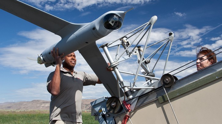
    Availability, Too. Along with accuracy, availability of position is also proving to be addictive; once we come to depend on location-enabled systems in our professional and personal lives, our needs and expectations will naturally tend toward that of continuous availability at all times and regardless of location. Although new constellations with more satellites and new, stronger signals help in this regard, augmentation of GNSS plays a key role on the path to more robust ubiquity. From a Trimble perspective, many of our new product launches during the past year incorporated deep integration of multiple measurement technologies. New systems combine GNSS with inertial measurement units, gyros, tilt sensors, seismometers, optical measurement, imaging systems, lasers, and other sensors or technologies, all enabling location and movement determination (increasingly in three dimensions) of more objects in more places — including, in some cases, even inside buildings. Looking to the future,we can expect the appetite for ubiquitous positioning to continue unabated.

    Multiple sensors are also used to collect non-geographic information. Increasingly, innovation is taking place at the intersection and aggregation of many different types of data, providing new insights and enabling more informed, more timely, and more insightful decisions across almost every facet of human activity. GNSS is rapidly expanding its role as an enabling technology in this regard. While we know that delivering consistently accurate positions is a decidedly nontrivial achievement, those positions are often just one component of increasingly large and complex endeavors. In fact, much of the innovation today lies in applications that enable new, more efficient approaches to work and enterprise management, and in the creation of new and powerful analytics from aggregated data.

    Global Utility, Global Business

    2013 marks another important anniversary: GPS officially reached Initial Operating Capability twenty years ago on December 8, 1993. In his 2011 State of the Union address, U.S. President Barack Obama cited GPS, along with the Internet, as key examples of how government-funded fundamental research can stimulate innovation and create whole new industries. The combination of those two technologies has transformed our lives in ways even the early visionaries may not have imagined. The U.S. government has contributed to the global success of GPS in ways beyond technological innovation. Following the 1983 Korean Airlines 007 disaster (caused in part by inaccurate navigation), President Reagan declared that GPS should be free and available to all, providing a stable policy foundation upon which successive U.S. administrations have continued to build, increasingly recognizing the importance of civilian GPS applications.

    Importantly, the United States strengthened this open-access policy framework by publishing the Interface Control Document for GPS, which enabled entrepreneurs and innovators anywhere in the world to bring to life their ideas about how this new technology in space could be used on Earth. For the most part, other governments have followed U.S. leadership in announcing predictable policy access to worldwide satellite positioning and timing availability, allowing innovation to take place wherever it may. In the process it spawned a truly global industry.

    Technology alone has not achieved the global impact of GNSS. Rather, it is the combination of technology, a transparent, stable policy environment conducive to global innovation and adoption, and the economics of a global market that together have led to so many people today enjoying the benefits that GNSS provides. Such alignment is equally important for the future: just as GNSS from the beginning built upon knowledge and achievement from around the world, its full international potential will be best realized through global, user-driven innovation, vibrant international entrepreneurship, and robust open markets. Given that we are still far from reaching that full potential, there is good reason for us all to have great expectations of GNSS operators, the industry, and the user community in 2014 and beyond.


    Peter O. Large joined Trimble in 1996 and has served as a vice president and a member of the executive committee since 2010. He holds a BSc (Hons) in surveying and mapping science from the University of Newcastle upon Tyne, UK, and an M.S. in management from Stanford University.

  • Directions 2014: Galileo IOV Passes with Flying Colors

    Marco Falcone
    Marco Falcone

    By Marco Falcone, System Manager for the European Space Agency in the Galileo Project Office

    Following the second Galileo launch in October 2012, leading to four operational satellites in orbit, a progressive chain of events has taken place in 2013 encompassing all Galileo Services, starting from the first position fix on March 12 (Figure 1), when navigation message continuous broadcast began.

    • Galileo System Time (GST) to Universal Time Coordinated (UTC) dissemination to timing users started on April 16 and since then has been maintained within 5 nanoseconds (Figure 2).
    • GPS to Galileo Time Offset (GGTO) dissemination started on April 22, favoring the use of our satellites for combined positioning with the GPS constellation. GGTO accuracy is well within 7 nanoseconds.
    • The first implementation of the Galileo Terrestrial Reference Frame (GTRF), aligned to the IGb08, an update of IGS08 (International Terrestrial Reference Frame 2008), has been available since May 27, including all deployed Galileo Sensor Stations sites.
    • The capability to disseminate Commercial Service data in the navigation message was demonstrated on June 25.
    • In July, several European Union Member States achieved the first position fix using Public Regulated Service (PRS) receivers as part of the EC-ESA joint PRS Participants To IOV (PPTI) campaigns, demonstrating PRS positioning and access control.
    • The first search-and-rescue (SAR) localizations using the operational mid-Earth orbit Local User Terminal (MEO LUT) in Maspalomas was exercised July 9, and the first dissemination of the acknowledgement via return link to users in distress was tested in October.

    The majority of performance verification tests has been successfully completed as part of the In Orbit Validation (IOV) experimentation campaign completed at the end of October 2013, demonstrating the achievement of the Galileo system’s expected performance. The average positioning accuracy for E1/E5a dual-frequency Open Service users is already around 8 meters horizontally and 10 meters vertically. This is an impressive result considering the small number of Galileo satellites in orbit and the limited ground infrastructure so far.

    Figure 1. Galileo first position fix (source: Timing and Geodesy Validation Facility).
    Figure 1. Galileo first position fix (source: Timing and Geodesy Validation Facility).

    But the single most important message from the In Orbit Validation campaign is that Galileo works, and it works well.

    The experience gained and lessons learned during the IOV period, especially in the domain of ground operations, have been very useful and will be addressed as a priority in the next phase, as part of the planned new versions of the Ground Control Segment and Ground Mission Segment.

    The launches in 2014 of the new FOC satellites manufactured by OHB will further increase the availability of positioning and timing accuracy to users.

    Complementary system validation campaigns will be carried out next year, moving towards commercial receiver technology for all categories of users, with particular focus on the mass market and the Public Regulated Service. Following the letter issued by the European GNSS Agency to Galileo chipset manufacturers in July 2013, an opportunity has been given to interested companies to take part in a test campaign to support the early introduction of Galileo in commercially available receivers. The campaign will be carried out next year, focusing on the compatibility of the devices with the reception of Galileo Open Service signals and their combined use with GPS and GLONASS. A number of mass-market chipset manufacturers and professional receiver manufacturers have already expressed their interest in participating in the campaign.

    Figure 2. GST and UTC prediction error (source: FOC WP1 System Engineering Technical Assistance).
    Figure 2. GST and UTC prediction error (source: FOC WP1 System Engineering Technical Assistance).

    Marco Falcone is system manager for the European Space Agency in the Galileo Project Office in Noordwijk, the Netherlands. He has been mission manager for the GIOVE-A and –B satellites, the precursors of the Galileo operational satellite constellation. Nowadays, his main task is to validate the overall Galileo system and to ensure that it fulfils in operations the required performance starting from the first four satellites of the In Orbit Validation Phase throughout the full deployment of the constellation. He received his Master’s degree in computer science from the University of Pisa, Italy and his Master’s degree in space systems engineering from the University of Delft, the Netherlands.

  • Directions 2014: Serve the World, Benefit Mankind — A System Matures

    Directions 2014: Serve the World, Benefit Mankind — A System Matures

    Chengqi Ran
    Chengqi Ran

    By Chengqi Ran, Director General of the China Satellite Navigation Office

    By adhering to the principles of independence, openness, compatibility, and gradualness, China has steadily pushed forward the deployment of the BeiDou Navigation Satellite System (BDS), following a planned three-step strategy. In 2000, BeiDou Navigation Satellite Demonstration System was completed. By December 2012, five geostationary orbit (GEO) satellites, five inclined geosynchronous orbit (IGSO) satellites, and four medium-Earth orbit (MEO) satellites had been launched, forming the constellation, and formally beginning service provision to the Asia-Pacific region.

    The important contribution of BDS for Chinese and global users is well-recognized. It will provide services to global users by around 2020.

    System Deployment

    Moving forward in 2014, additional satellites will be launched to form the next constellation, while regional service performances will be advanced and expanded to worldwide scope. Approximately 40 satellites in total will have been launched by about 2020.

    Current System Performance

    Single-frequency horizontal, vertical, and three-dimensional positioning accuracy has been achieved at levels better than 10 meters, 10 meters, and 14 meters, respectively. Timing accuracy is better than 50 nanoseconds. Velocity accuracy is better than 0.2 meters per second. Carrier-phase differential accuracy is about 2–3 centimeters. During the past year, BDS has been continuously improved and enhanced, while its service performances in some regions dramatically surpassed the indicators given earlier.

    Application Promotion

    The application of BDS has played an important role in China, especially in advancing science and technology. Chinese scientists and engineers have intelligently and enthusiastically embraced China’s independent navigation satellite system and have made great progress in research and development of navigation satellite technologies, as well as new breakthroughs in the production of navigation chips, antennas, terminals, and integrated services.

    In 2012, the total output value of China’s satellite navigation and location-based service (LBS) industries reached 81 billion renminbi (RMB, equivalent to $13.2 billion), which amounts to 8 percent of the global sector. At the end of 2012, BDS civil user terminals totaled 230,000 units, and BDS-related industrial output value was close to 4 billion RMB ($652 million), which is about 5 percent of the national output.

    A series of policies aimed at strengthening the application of satellite navigation are under formulation in China, and the Mid- and Long-Term Development Plan for the National Satellite Navigation Industry has been issued. Satellite navigation has become one of the emerging industries with strategic importance. BDS is propelling China’s satellite navigation and LBS industries into a new era.

    Distribution of visible in-orbit BeiDou satellites.
    Distribution of visible in-orbit BeiDou satellites.

    International Cooperation

    China upholds and adheres to the concept of “BeiDou is of China, and also of the world,” advocating compatibility and interoperability among navigation satellite systems, and endeavoring to stimulate global widespread use of navigation satellite systems. To enable users to enjoy more reliable and ensured satellite navigation services, BDS has joined in international GNSS monitoring and assessment cooperation, making use of global monitoring stations, sharing international monitoring statistics, implementing joint assessment studies, and striving to offer trustworthy monitoring and assessment data and products to users.

    To achieve BDS’ envisioned coverage area more quickly, the BeiDou+ Application Demonstration and Experience Campaign (BADEC) has been initiated. “BeiDou’s tour to the Asian-Pacific region” and “BeiDou’s tour to the ASEAN” have been kicked off to accelerate application promotion of navigation satellite systems in many countries. To popularize satellite navigation technologies, particularly enhancing its recognition and application in developing countries, BDS has provided academic education, short-term training, and thematic lectures with support from International GNSS Exchange and Training Center.

    China also holds the annual China Satellite Navigation Conference, actively participates in international exchange activities on satellite navigation, and engages in academic exchanges, high-level forums, and popularization of knowledge.

    Future Outlook

    BDS is also committed to:

    • establishing navigation-satellite augmentation systems in the Asia-Pacific region and worldwide, developing better service performances, to provide decimeter-level accuracy in real time and centimeter-level accuracy after post-processing;
    • setting up satellite-navigation products-quality testing certification centers;
    • speeding up formulation of standards and intellectual property rights;
    •  joining international organizations such as the International Civil Aviation Organization (ICAO), International Maritime Organization (IMO), and Third-Generation mobile communication standard Partnership Project (3GPP);
    • strengthening compatibility and interoperability with the other navigation satellite systems;
    • promoting BDS/GNSS applications in transportation, energy, power, finance, telecommunication, disaster reduction and relief, and so on, to realize the BDS objective of serving the world and benefiting mankind.

    BDS will fully exploit the unique advantages of navigation, communication, and augmentation integration, enhance its short message service (SMS), and providing faster positioning and timing capabilities. BDS will also effectively integrate satellite- and ground-based augmentation systems, and insist on implementations of compatibility and interoperability among multi-GNSS, to enable its organic integration with mobile communication, LBS, and the Internet, and provide better quality, more reliable and efficient services to eco-social development, public security, and individual users.


    Chengqi Ran is the director general of the China Satellite Navigation Office and press spokesman of BeiDou Navigation Satellite System. He graduated from Tsinghua University with a Master’s degree in industrial engineering, and previously was director of the General Technology Department in the China Satellite Navigation Project Center.

  • Directions 2014: New Horizons of GLONASS

    Denis Lyskov
    Denis Lyskov

    By Denis Lyskov, Deputy Head of the Russian Space Agency, Roscosmos

    The fundamentals of Russian government policy in satellite navigation are defined in Presidential Decree #638 of May 17, 2007, and specify that:

    • GLONASS services are provided globally and free of any user fees;
    • GLONASS is used as a basis of the National Positioning, Navigation and Timing System.

    To efficiently implement the government policy in satellite navigation, in March 2012 the Government approved the dedicated Federal Program focused on GLONASS sustainment, development, and expansion of applications. This program covers activities aimed at:

    • improving the accuracy and integrity of navigation;
    • ensuring conditions for guaranteed positioning, navigation, and timing solutions in restricted visibility, interference, and jamming environments;
    • enhancing current application efficiency and broadening application domains.

    This year, the extensive efforts aimed at development of new generation GLONASS satellites, augmentations, and performance monitoring facilities were taken. The results obtained help to define the main directions of GLONASS development for the upcoming years.

    Space Segment

    The new navigation satellite will ensure navigation services for all categories of users using current frequency-division multiple access (FDMA) signals in L1 and L2 as well as new code-division multiple-access (CDMA) signals in L1, L2, and L3 bands. The full set of GLONASS signals will be transmitted using two separate phased antenna arrays — one for FDMA signals, and the other for CDMA signals. Introduction of new signals broadens the possibilities of improving the GLONASS orbital constellation configuration, structure and composition of navigation message data, as well as accuracy, reliability, and integrity of navigation solutions in various conditions. The constellation sustainment plan includes the launch of GLONASS-M-55 satellite in 2014. This satellite, similar to GLONASS-K-11 launched in February 2011, will carry an L3 navigation payload and transmit a CDMA signal in L3.

    The L3 CDMA signal will also be transmitted from seven more GLONASS-M satellites planned for launch in 2014–2015.

    The implementation of a GLONASS modernization program will produce a more than four-fold improvement of accuracy. This will be made by means of:

    • ground control segment upgrade;
    • introduction of a new on-board atomic frequency standard, based on different technologies;
    • introduction of advanced technologies of satellite control, based on intersatellite links in radio frequency and optical bands;
    • transition to PZ-90.11 Geodetic Reference System aligned to the International Terrestrial Reference Frame (ITRF) at the millimeter level;
    • synchronization of the GLONASS time scale with Coordinated Universal Time UTC (SU, for Soviet Union) at the level of less than 2 nanoseconds while keeping the UTC (SU) own long-term stability at 10-17.

    Augmentations

    Augmentations play an important role in improving GLONASS performance. With the launch of Luch-5V into an orbital position of 95° E in 2014, the first phase of the System of Differential Correction and Monitoring (SDCM) constellation deployment will be completed. SDCM will provide satellite-based augmentation services (SBAS) in L1 (1575.42 MHz). Simultaneously, the deployment in the Far East of the Russian Federation of uploading and monitoring facilities for Luch-5A positioned at 167° E will be completed. Special attention is being paid to ensuring compatibility of Luch-5B satellite (16° E) and Inmarsat-3F2 satellite (15.5° W) carrying a European Geostationary Navigation Overlay System (EGNOS) payload.

    The future transition to using heavier satellites carrying L1/L5 transponders will present an important stage of SDCM development. The first launch of such satellites is tentatively planned for 2018.

    With the purpose of improving the quality of SDCM services, the ground network consisting of several dozen sites will be deployed over the Russian territory, and more stations will be deployed along the Russian border to improve the accuracy of generating the vertical ionospheric delay map.

    Apart from SBAS technology development, a system for ensuring Precise Point Positioning (PPP)service is planned for development. PPP service will be provided using geostationary Earth-orbit (GEO) satellites transmitting in L1/L3 GLONASS bands. The L1/L3 transponders are planned to be installed on board future GEO satellites. Considering the common parameters (carrier frequency, pseudorandom noise pulse rate, data rate) of PPP and GLONASS’ own signals, the informative capacity of the former is an order of magnitude greater to ensure rapid broadcast of high-precision orbits and clocks.

    For PPP technology development, the global network of measuring facilities is of extreme importance. The global network ensures global monitoring of navigation signals and generation of initial data for high-precision determination and prediction of orbits and clocks.

    International Cooperation

    Cooperation with GNSS providers focuses on protecting the spectrum allocated to radionavigation satellite service, pursuing compatibility and interoperability of GLONASS and SDCM with other GNSSs and augmentations, creating an international GNSS monitoring system.

    One of the priority directions of international scientific cooperation is the cooperation with the International GNSS Service through the exchange of measurement information between its members. At the same time, GLONASS measuring and monitoring facilities will receive and monitor all open navigation signals of all GNSSs.

    A lot of attention is paid to enhancing GLONASS awareness. Since 2009, the International School on Satellite Navigation has been held annually in the Russian Federation. The Russian Federation has been preparing to host the United Nations Workshop on the Applications of Global Satellite Navigation Systems.


    Denis Lyskov is state-secretary, deputy head of the Federal Space Agency of Russia (Roscosmos). He started his carrier in the Russian space industry after graduation from the Moscow Aviation Institute in 1996. He has been working in Roscosmos for the last two years and supervising the GLONASS program since June 2013.

  • Directions 2014: Keeping Our Commitment to Civil Users

    Directions 2014: Keeping Our Commitment to Civil Users

    Colonel William T. “Bill” Cooley.
    Colonel William T. “Bill” Cooley.

    By Colonel William T. “Bill” Cooley, U.S. Air Force, Director, Global Positioning System

    The cliché “time flies when you’re having fun” accurately describes how quickly the past six months have passed for me. In a program as challenging, rewarding, and mission-critical as GPS, it is full-speed ahead all the time. As the GPS director, I am acutely aware of the importance of time — particularly high-accuracy time. Since declaring initial operational capability in December 1993, the extremely precise time service delivered by GPS has enabled numerous technological advances around the globe. While extremely proud of the accomplishments over the past 20 years, I look forward to the next 20 years, as GPS brings on new signals and continues to deliver on its promise of a worldwide free positioning, navigation, and timing (PNT) service. This article elaborates on the GPS Directorate commitment, along with the 2nd Space Operations Squadron (2 SOPS), to provide unparalleled space-based PNT accuracy, availability, and reliability to the civil community.

    The first commitment, arguably the most important for users everywhere, is the commitment to high accuracy for space-based PNT. After speaking at the ION GNSS+ conference and meeting many of you in Nashville this September, I realized that some users remain worried that selective availability (SA) — the intentional degradation of public GPS signals — could return and negatively impact GPS signal quality. SA was discontinued in May 2000 to provide an increased level of accuracy to all users around the globe. Since that time, the U.S. government has adopted a policy to no longer use SA and, furthermore, in 2007 removed that function from the upcoming GPS III satellites. The GPS Performance Standard for the Standard Positioning Service reflects our commitment to accuracy by ensuring the signal-in-space (SIS) user range error remains low: better than 4-meter accuracy. Figure 1 shows the record-setting SIS accuracy and how GPS meets and far exceeds this guarantee: consistently better than 1-meter accuracy! The 2 SOPS operators who command and control the GPS satellites do a masterful job ensuring global PNT accuracy is as good as it can be.

    Figure 1. Standard Positioning Service signal-in-space performance.
    Figure 1. Standard Positioning Service signal-in-space performance.

    The quality of these services, however, does not permit the GPS enterprise to rest in the comfort of past success. We are dedicated to updating and modernizing the program.

    The second commitment I’d like to highlight includes the GPS pledge for constellation sustainment and service availability. This is a guarantee to maintain a constellation of at least 24 satellites continuously broadcasting the GPS signals, providing a low dilution-of-precision value around the globe. Current efforts to meet this commitment range from replenishing unhealthy satellites to deploying improved, modernized satellites and corresponding ground support. For example, the GPS IIF satellites are rapidly becoming an integral part of the GPS constellation. With four IIFs on-orbit and a fifth soon to be launched, the constellation continues to exceed the 24-satellite requirement.

    The third commitment — to modernize the GPS constellation with new signals — is best illustrated by, but not limited to, the modernized GPS IIF and GPS III satellites that are beginning to populate the constellation. In addition to four GPS IIF satellites now on orbit, the remaining GPS IIFs are either ready for launch or in final testing.

    Down the road, GPS III satellites are completing development and progressing through early production. They will add the fourth civil signal, L1C, for civil users worldwide. Earlier this year, the GPS III program shipped the GPS non-flight satellite testbed (an engineering development unit) to Cape Canaveral; it successfully communicated with the next-generation operational control system (OCX), essentially as it would for launch and on-orbit check and control of functional GPS III satellites. The operational portion of the GPS ground segment, OCX Block 1 is on track to begin operations in 2016, modernizing the control segment by providing mission operation control of all legacy signals, as well as L2C and L5; later, OCX Block 2 will support L1C.

    GPS civil users will soon be able to take advantage of the L2C and L5 signals that broadcast the modernized civil navigation message (CNAV); this will effectively eliminate the need to access the L1 and L2 P(Y) signals through codeless or semi-codeless techniques. These codes permit civil users to access dual-frequency solutions for precision applications (using dual-frequency enables ionospheric corrections for highly accurate PNT solutions). Compared to the L1 C/A signal, L2C features faster signal acquisition, enhanced reliability, and greater operating range. L5 will provide for increased safety-of-life applications with broadcast power even greater than L1 C/A and L2C combined, increased bandwidth, and advanced signal design. Regardless of the early availability of L2C and L5, semi-codeless users will be able to access P(Y) code — unhindered and unaffected by fully tested and vetted flex-power operations — until the end of 2020. Overall, these modernization efforts emphasize a commitment that availability surpasses simply putting satellites on orbit.

    Finally, the GPS Directorate is committed to providing a high-quality service that is highly reliable. We achieve this by fielding first-rate satellites, conducting extensive test campaigns before deploying new capabilities or launching new satellites, and working closely with the operators at 2 SOPS, ensuring our constellation delivers top-quality PNT signals. An example of diligent testing is the recent live-sky test of the CNAV message on all GPS IIR-M and IIF satellites this past June. An example of a modernization feature that will enhance reliability is the capability of GPS III satellites to autonomously monitor the atomic clocks that drive the signal, thereby protecting users from clock instability and resulting signal errors.

    Our demonstrated commitment to deliver accurate, available, and reliable space-based PNT allows innovators around the world to invest confidently in the creation of a multitude of GPS and GPS-enabled technologies that shape the way we live. GPS and its related technologies go far beyond letting you find the deli down the street and “checking in” to let your friends know what you’re up to on Facebook; it tracks financial transactions, enables precision farming, and allows accurate real-time updates on natural disasters such as earthquakes and tsunamis with capabilities that organizations like the NASA Jet Propulsion Laboratory and the International GNSS Service provide using GPS. The GPS Directorate is keenly aware that innovators invest their time and talent because they know they can depend on GPS availability. Our commitments are not just “feel-good” words; they are our mission and promise to the world.

    I am very proud of the men and women in the GPS Directorate and thrilled to be part of this great team as the new GPS program director. The commitments listed here provide a glimpse into the services provided by the GPS enterprise. I am excited about bringing modernized signals to the world, but more excited to learn how the PNT community will use these signals to develop new innovative and useful applications. The world is easier to navigate because of GPS and GPS-enabled technologies, all of which rely on services the GPS enterprise provides: accuracy, availability, and reliability. We are committed to delivering these services as we modernize and improve the enterprise to continue GPS as the gold standard of space-based PNT.


    Colonel William L. cooley is Director, Global Positioning Systems (GPS) Directorate, Space and Missile Systems Center, Air Force Space Command, Los Angeles Air Force Base, California.

  • Out in Front: Above All, Leadership

    Out in Front: Above All, Leadership

    GPS Summit 2002 award.
    GPS Summit 2002 award.

    Just took a stroll down memory lane, leafing through the pages of the December 2002 issue of this magazine. They contain predictive essays of that era — Directions 2003 — and a transcription of the panel discussion from the very first Leadership Dinner, then called the “GPS Summit.” I was there, running the door, riding the audio recorder, handing out bronze presenteaux (pictured here) to departing guests.

    We have carried on the tradition of that event, the brainchild of Glen Gibbons (whose December 2002 editorial headline I have repeated here) and Richard Fischer, nine times now. We carried the show, innovating as we go, from Long Beach to Fort Worth to Savannah, back to Portland and thence to Nashville. We shall convene again in Tampa next year. We’ve had spirited debates, campaigns and elections (the Satellite Party versus the Signal Party), a history of GPS origins from Brad Parkinson himself, a recognition of the pioneers from the early era who built the system from scratch, a Grand Game of GNSS negotiation and trading, horse racing, physics trivia, and this year, a spoofing simulation (see the back page of this magazine).

    Somehow amid the fun of each occasion, we managed to squeeze in a healthy dose of thought leadership. This year’s installments you will find on pages 28 to 49, including dinner remarks from the four recipients of this year’s Leadership Awards, and essays by upper-level if not the top-level executives at each of the four GNSSs.

    For added perspective, see these excerpts from the 2002 discussion high atop the Portland Hilton.

    Javad Ashjaee (then CEO and president of Javad Navigation Systems): “There is no end to the enhancement that we can do in signal processing, assuming that Intel and others will not stop giving us the tools that we need. As you see, the front line of this is microprocessors.”

    Kanwar Chadha (then founder and vice-president of marketing at SiRF Technology): “As far as the consumer is concerned, it comes down to what they are buying, and what’s the value proposition. I can tell you from personal experience, it’s not purely a technology decision.”

    Steve Moran (then director for civil space programs at Raytheon, where he still works as director, GPS mission solutions): “We manage a positioning and navigation system, rather than a positioning and timing service — and that’s a fundamental change that needs to come about in the way we look at GPS.”

    Bob Denaro (then vice-president and general manage at NavTeq): “One day soon we will have digital paper. A map with high-resolution addressable data on what looks and feels, and most importantly, costs like a sheet of paper. My position shows up as a bright spot moving along the paper as I move.”

  • 2013 Leadership Awards: The Honorees Speak

    2013 Leadership Awards: The Honorees Speak

    The GPS World 2013 Leadership Awards.
    The GPS World 2013 Leadership Awards.

    This article reproduces the acceptance speeches given by the winners of GPS World’s 2013 Leadership Awards, at the Leadership Dinner in Nashville in September.

    The Leadership Dinner was sponsored by Lockheed Martin and Exelis.

    Nominations for the 2013 Leadership Awards came from the Editorial Advisory Board of GPS World, from the 2012 Award winners, and from a select handful of industry executives. A similar group of GNSS community members, roughly double in size, voted for the final Award winners presented here.


    Success with a New System, QZSS

    Japanese Government Approves a Four-Satellite Constellation

    Headshot: Satoshi KogureIt is my great honor to receive this GPS World Leadership Award 2013 on behalf of my team. I’d like to express my gratitude to my family, my colleagues, and especially my team members. We jointly developed the first satellite of the Quasi-Zenith Satellite System in Japan.

    The project was established after long discussion between the Japanese government, industries, and user communities, as well as other GNSS providers. QZSS is now providing GPS availability and capability enhancement to Asia and the Oceania region as a regional augmentation system. We are very proud of a great achievement on the first satellite technical validation. Our first satellite can provide the same signal-in-space user range error performance as the latest GPS Block IIR-M and IIF space vehicles.

    As a result, considering our achievement, the Japanese government has decided to proceed with the QZSS program to the second phase. So we will have three additional satellites by 2017 and we’ll start the augmentation service surrounding Japan, East Asia, and the Pacific region from 2018, using the four-satellite constellation.

    The Japanese government is conducting the system design for the operational QZSS, and the Japanese Aerospace Exploration Agency is continually supporting the government’s activity. We expect that QZSS will bring great social benefits to life in the Asia-Pacific region in a wide variety of fields.

    Again, on behalf of all the people who have been involved in the QZSS project, I give my sincere appreciation for this reward. I would also like to acknowledge everybody in this room,  because we have learned so many things from this wonderful society. So it is my great pleasure to share my gratitude with you. Thank you very much.

    The One Constant: New Challenges

    Jamming, Spoofing, Squeezing, Security, and More

    Headshot: Per EngeFirst and foremost, thank you for this wonderful award. It caused me to reflect on all of the wonderful people that I have worked with over the years. This morning, I tried to list these people for NDGPS, WAAS, and APNT; and the lists were too long to repeat in five minutes. For WAAS alone, the list includes people from the Federal Aviation Administration, Stanford University, AJ Systems, RTCA, Raytheon, Zeta, Inc., and the Mitre Corporation. This beautiful award reflects on the efforts of everyone on these long lists.

    These lists also remind me of the remarkable community that is GNSS today — all of us. Apparently, we still have our work cut out for us. After all, I understand from this very conference that:

    • GNSS is blocked;
    • GNSS is jammed;
    • GNSS spectrum will be squeezed;
    • GNSS is spoofed;
    • GNSS is scintillated;
    • GNSS is too expensive;
    • GNSS is Swiss cheese (thank you, Nunzio).

    Honestly, I was not really aware that GNSS is all that fragile. It seems to work fine to me. But let us take the point: these threats are worth our worry, and mitigation will require the full strength of our far-flung community.
    Spoofing is worth some special mention. It is certainly interesting, and the theory will be gorgeous. However, I remind you of Faflick’s theorem:

    “In your professional life, you will work on many interesting projects. With luck, you will work on some important projects; those will be important to your company, your nation to the global community. However, (Faflick asserts) you will never ever work on any projects that are both interesting and important.”

    Well, it seems that GNSS and WAAS are exceptions. But two such small exceptions should not cause us to turn our back on a theorem as powerful or persuasive as the one provided by Faflick. If we apply the theorem, then spoofing cannot be important, because it is interesting. However, I think spoofing is also an exception to Faflick’s theorem.
    After all, today’s e-security is based on three security factors: what we know (passwords), what we carry (key fob), and what we are (fingerprints, iris scan). And it is not enough. For example, our health records will soon be online, and the damage caused by losing control of these health records would be great. To meet this challenge, we need to rejuvenate the original security factor: location. In the past, transactions were secured by our presence. In the world of e-commerce, this factor has disappeared, and we must use GNSS to approximate this ancient and effective security factor.

    All of this will require the best effort of this precious community of ours.

    Science Powers New Applications

    Radio Occultation Techniques May Warn of Natural Disasters

    Photo: Attila KomjathyI am deeply honored to receive GPS World’s GNSS Leadership Award this year. Many thanks to the magazine and the international group of GNSS experts for recognizing my contributions to the GNSS community with this prestigious distinction.

    I have been privileged to receive support and guidance from a great number of colleagues and friends over the years — too many to list, but I thank them all. If I am a good researcher, it is because I had excellent mentors. Chief among them is Professor Richard Langley of the University of New Brunswick, sitting in the audience, who believed in me and taught me to leave no stones unturned in my research and to continue questioning myself along the way.

    Professors George Born and Penina Axelrad also had immeasurable influence on me at the University of Colorado in becoming a GNSS researcher. I am greatly indebted to Tony Mannucci and Brian Wilson at NASA’s Jet Propulsion Laboratory for creating a stimulating, conducive, and rewarding research environment in my group at JPL. I would like to thank my wife Katie and sons David and Adam who have been most patient and who have supported me all these years.

    At the early stages of my career, working with GPS data at the University of New Brunswick, we routinely had access to about 40–50 GPS receivers worldwide, and this was after a laborious process of hunting down individual RINEX files. Now, we process data from about 1,200 GPS and GLONASS stations daily in an automated fashion including daily, hourly, and streaming GPS sites. Data centers including ours at JPL generate real-time products to retrieve three-dimensional electron densities using global assimilative ionospheric modeling and other techniques. As computational power increases, I envision that we will see new scientific discoveries evolving with real-life applications and tangible benefits to society. These emerging applications already include the detection of small perturbations in the ionosphere using GNSS real-time measurements that may be indicative of natural hazards generating acoustic and gravity waves in the atmosphere.

    Why is this important to us, other than being of scientific interest?

    The advances in GNSS ionospheric measurements may soon be capable of augmenting tsunami early-warning systems, for instance. Other potential applications include detecting volcanic eruptions in remote corners of our planet using GNSS data. Less innocent yet equally important may be detecting nuclear tests using GNSS ionospheric measurements.

    Another scientific application in the works is the creation of three-dimensional coupled ocean-atmosphere-ionosphere modeling capabilities. These models are at the initial phases of development, running on supercomputers including one at JPL. In a few years, we expect to see that coupled physics-based modeling will help detect and confirm natural hazards and artificial explosions on the Earth’s surface.

    In a not too distant future, I anticipate that we will see natural hazard-generated signatures detected using low-Earth orbiting satellites. Initial results suggest that some of the largest events including large earthquakes, tsunamis, and meteor events may be detected in radio occultation measurements. I expect to see a fleet of low-Earth orbiters monitoring Earth’s ionosphere in real time, looking for signatures of tsunamis, earthquakes, volcanic eruptions, meteor events, large forest fires, or nuclear tests.

    It is also tempting to use this technology and associated algorithms to claim ionospheric precursors of earthquakes. While I am not convinced about the technical feasibility of ionospheric earthquake precursors, it is a fascinating research area, which has generated heated debates in the community over the years.

    With the abundance of different constellations including GPS, GLONASS, BeiDou, QZSS, and others using ground and space-based observations, we are clearly entering a new era when mid-ocean 10-centimeter-level tsunami waves may be detected in the ionosphere at 400 kilometers altitude in real time! Could you have imaged even only 10 years ago that by looking at real-time ionospheric measurements we could infer 10-centimeter-level tsunami waves well before they reach a shoreline? This might help decision makers to save human lives and potentially billions in material damages.

    In closing, let me repeat that I am deeply honored to have received the GPS World Leadership Award. I look forward to continue pushing the boundaries of scientific and technical discoveries using GNSS technologies.

    Thank you very much.

    Getting to the Plus in GNSS

    Multi-Constellation, Environments, Multi-Sensors

    Headshot: Peter GrognardDear friends, dear colleagues, it is with pride that I receive this award tonight, in this very town where I attended ION GPS for the first time in 1998, and where I met some of you for the very first time.

    Septentrio didn’t formally exist then, but while at the Interuniversity Microelectronics Center IMEC in Belgium, and just returning from a four-year assignment in the United States, where I witnessed the beginning of civil GPS, I was preparing the creation of the company that I am so proud of, and that is first and foremost a very international family of unique, talented people that I enjoy working with every day!

    Hence, my first words of gratitude go to my world-class team that for 15 years now has been at the forefront of advanced GNSS receiver development.

    I also take the opportunity to thank some of our long-standing customers and partners, who all those years have given us their business and confidence. In particular, let me thank here tonight the European Space Agency, with whom we have worked hand in hand for more than 10 years. Thank you for your confidence and business — it is a tremendous honor to work with you, and we have enjoyed the truly historic milestones on the Galileo program as much as you have.

    As the motivation for tonight’s award, a number of important new developments were mentioned, as achieved by Septentrio throughout an already very busy year:

    • the successful position/velocity/time (PVT) calculation using BeiDou satellites in a three-constellation solution on a commercial PolaRx4 platform just days following the official release of BeiDou’s Interface Control Document;
    • the first autonomous real-time Galileo PVT calculation. The standalone position was calculated from in-orbit navigation messages using a standard PolaRx4 GNSS receiver equipped with commercially released firmware;
    • the first four-constellation PVT performed by a standard commercial receiver. The 3D-position fix happened shortly after the Galileo IOV satellites began transmitting, for the first time ever, a fully usable navigation message as part of an ESA experiment;
    • and last, but certainly not least, the first Galileo PRS-only positioning for European Secured Navigation using only the encrypted Galileo Public Regulated Service (PRS) signals broadcast by the four Galileo In-Orbit Validation satellites.

    I’ll share with you some future directions for us, outlining three major themes running across our developments.
    When we first met here 15 years ago, the focus of our industry was all about GPS. Today, our favorite yearly rendezvous has been rightly renamed ION GNSS PLUS. GPS is not alone anymore. Not alone, because who today would give up the great signal availability that multi-constellation reception brings us? Not alone, because who would claim that GPS can survive in its own bubble of safety without considering the environmental conditions it lives in?

    Finally, not alone because modern positioning and navigation require multi-sensor fusion to perform at their best.

    Multi-Constellation Reception. Septentrio has, from its very beginning, focused on developing multi-frequency, multi-constellation receivers, at a time when this was far from common. Our first proprietary ASIC was a highly integrated GPS-GLONASS-SBAS chip, which we used as the core of the first generation of Septentrio multi-system/multi-frequency receivers.

    “All the signals in the sky” was, is, and will always remain one of our key leitmotifs. We follow with great interest the new developments around the world, for instance for future-generation EGNOS and Galileo systems. As a practical example, I’d like to mention the work that we conduct with European partners on EGNOSv3.
    Also, it’s my pleasure to announce here tonight the development of our fourth-generation correlator ASIC, GReCo4: all–in-view, all-signals, all-Septentrio!

    The consistent focus on multi-system, multi-frequency receivers was obviously driven by the desire to make very powerful, robust GNSS receivers that would provide high-precision PVTs under the widest range of circumstances.

    Our unwavering support for Galileo from the early days was also based on the fact that we could, at the turn of the century, easily receive 15–20 satellites: GPS+GLONASS+EGNOS.

    Environments. Obviously, no matter how many independent systems are combined, GNSS remains vulnerable and sensitive to all kinds of interfering sources, human-made and made by Mother Nature. That’s why in recent years, we have been investing a lot of effort in understanding and mitigating the environmental disturbance that affects GNSS receivers.

    While we must be humble for, and cannot (completely) tame the forces of Mother Nature, Septentrio has spent a lot of effort on ionospherical receivers. These developments have been conducted by a Septentrio-led consortium of European and Brazilian partners, with as a tangible outcome the Septentrio PolaRxS receiver, aimed at measuring the ionosphere. This unique state-of-the-art receiver is being deployed worldwide by our customers and partners, which helps us improve our understanding of ionopheric behaviour and its impact on GNSS receivers. Our goal: making the most robust professional receivers in the world.

    With respect to interference, both intentional and unintentional, Septentrio will continue to improve and expand its solutions. Septentrio’s state-of-the-art Advanced Interference Mitigation (AIM) is AIMed at providing our customers the most robust reception under adverse and hostile conditions.

    Multi-Sensors. “All of the signals in the sky” only works if your receiver sees the sky. If there are no satellite signals — for instance, because of blockage of the signals in a container terminal — one obviously needs other sensors to take over and guarantee the continued availability of a PVT-solution.

    For several years, we have been offering combined GNSS-INS solutions for a variety of applications, such as management of container terminals. One of our very first customers was the Port of Singapore Authority.
    Septentrio will continue to work along these three exciting axes. We look forward to communicating new trends and developments to you wonderful, global GNSS+ community!


  • A Glowing Report Doth Not a Golden Future Make

    The tech press and broad public media have both made much ado about a November market report from the European GNSS Agency (GSA). Most accounts have focused on a GSA prediction of an installed base of 7 billion GNSS-enabled devices worldwide by 2022, and nearly every account has replicated the GSA math to trumpet “almost one for every person on the planet.”

    Oh Hosanna.  We (will) have reached holy ground at last.

    Other than asserting that this bonanza “has the potential to deliver additional significant benefits, not measured in this report, especially in terms of time and fuel savings, as well as efficiency gains,” neither the GSA itself nor any pundit’s account of the report that I have seen ventures to speculate on how this might actually change daily human life. Hopefully ‘twill not be on the order of how cell phones have affected society, communication, and interaction; read tweeting and social-network stress. But knowing what little we do about human nature, this possibility is not at all to be discounted.

    Allow me to walk the plank out into left field long enough to quote from a 2009 NBC News Science report titled “Is Twitter evil?”  “Researchers probing the workings of the brain have found that it takes longer for feelings of social compassion and admiration to register on our neural circuits — and they worry that the rapid-fire effect of texting and tweeting could have ‘potentially negative consequences’ for our moral fiber.”

    Could total, global, continuous, pervasive location-awareness in the palm of everyone’s hand possibly lead down a similar path? I’m sure that cell-phone enthusiasts also promised vast, billionish-plus benefits, with absolutely no downside, three decades ago.

    If I can pry myself back from Nostradamus mutterings — and I am sure you are glad that I have now done so — the GNSS Market Report Issue 3 contains a great deal of data worth considering.

    Said document foresees compound annual growth rates (CAGRs) for “GNSS core” and “GNSS-enabled” revenues increasing by 9 percent through 2016 and 5 percent through 2020, to attain €350 billion ($478 billion) per year. Of the 2022 total, GNSS core revenues will comprise about €100 billion (US$137 billion).

    To further differentiate “core” and “enabled,” this from the report’s early Market Definitions section:

    “This market report primarily considers the core GNSS market. For multi-function devices, such as smartphones, the core market includes the value of GNSS functionality only (rather than the full device price) and service revenues directly attributable to GNSS functionality (e.g. data downloaded by smartphones to use Location-Based Services).

    “For multi-function devices, a correction factor is taken into account, for example:

    • GNSS-enabled smartphone: only the value of GNSS chipsets is counted, estimated at 1% of the price.

    • Personal Navigation Devices (PNDs): 100% of retail value since GNSS is the key enabler.

    • Aviation: the value of the GNSS receiver inside the Flight Management System is taken into account.

    • Precision agriculture system: the retail value of the GNSS receivers, maps, and navigation software is counted.

    “The Executive Summary also presents results for the enabled market. The enabled market represents the services and devices enabled by GNSS, and includes the core market. For the enabled market, the entire retail value of the smartphone is included.”

    The 72-page report breaks out market segments, focusing in turn on: location-based services (LBS), road, aviation, rail, maritime, agriculture, and surveying. The weight of the report, as you might guess by the necessity of reaching that 7 billion figure, falls primarily on LBS, a heading that for the GSA encompasses “smartphones, tablets, digital cameras, laptops, fitness and people-tracking devices, and mobile-data revenues.”

    What’s good for the mass market must surely be good for satellite makers and operators around the world, as they attempt the jump from one to many systems.  That’s the underlying but unstated premise of the report.  “Multi-constellation receivers become widely available on the market” trumpets the Executive Summary headline on page 8.  In what is certainly the money pitch for the Prague-based, European Union-funded agency, “Galileo is recognised as a valuable element in multi-constellation systems, and it is already present in more than 30% of receiver models, well ahead of its full operational capability.”

    Nevertheless, GLONASS is the second GNSS constellation choice of receiver manufacturers after GPS.

    For BeiDou, the researchers will only venture that “Several equipment manufacturers, particularly those based in Asia-Pacific, have started to offer BeiDou-enabled models.”

    More than 70 percent of models on the market are GPS-SBAS capable (SBAS comprising WAAS, EGNOS, and MSAS) and this penetration will grow further.

    In a final provocative note (neither final nor provocative from the GSA’s point of view, although I confess it causes me a vague unease), the four-fold increase in the number of GNSS devices will be “largely driven by increased penetration in regions outside Europe and North America.”

    Production of the report relied on “advanced forecasting techniques together with a validation process with market experts.”

    Lest you feel unfairly treated by my curmudgeonly take, here is some actual data generated by and taken from the report.

    Global GNSS Market Size, from GNSS Market Report 2013 Issue 3
    Global GNSS Market Size, from GNSS Market Report 2013 Issue 3
    Installed Base of GNSS Devices by Region, from GNSS Market Report 2013 Issue 3
    Installed Base of GNSS Devices by Region, from GNSS Market Report 2013 Issue 3
    GNSS capability in receivers, from GNSS Market Report 2013 Issue 3
    GNSS capability in receivers, from GNSS Market Report 2013 Issue 3


  • Directions 2014: On the Path to Early Services

    Directions 2014: On the Path to Early Services

    Headshots: Eric Chatre, Horst Faas, and Marco Lisi By Eric Chatre, Horst Faas, and Marco Lisi

    With four satellites in space, launched by pairs in October 2011 and October 2012 from French Guiana, the Galileo project is now successfully completing the In-Orbit Validation (IOV) phase. The Galileo space, ground, and user segments have been qualified through extensive on-ground and in-orbit tests, and operations, of a core satellite constellation and the associated ground segment.

    The IOV architecture is being implemented as an integral part of the Full Operational Capability (FOC) — that is, the complete system, consisting of 30 satellites and a set of remote stations distributed worldwide to command and monitor the constellation and deliver the navigation and timing services to the users. Now that the overall design has been validated, the system will be progressively completed, in a staggered approach, to reach the FOC.

    Figure 1. Galileo System Architecture.
    Figure 1. Galileo System Architecture.

    Galileo System Overview

    A joint initiative by the European Union and the European Space Agency, Galileo is one of the most ambitious and technologically advanced service-oriented systems being developed in Europe. A navigation satellite programme under civilian control, it is meant to provide positioning, navigation and timing signals on a global scale.

    Galileo is based on a constellation of 30 satellites organized in a 24-satellite nominal constellation plus six active spares, a worldwide network of ground stations, and a number of Control Centres established in Europe to control the constellation, perform the navigation mission management, and monitor system performances

    The Galileo programme is following an incremental path towards the deployment of the complete system and the exploitation of services.

    Figure 2. Galileo Incremental Implementation Plan.
    Figure 2. Galileo Incremental Implementation Plan.

    The programme has been structured according to the main following phases:

    • IOV phase, to develop and validate in-orbit performance;
    • Initial Operational Capability (IOC) phase, including Early Services, to start delivering limited but guaranteed services, promoting chipset and receiver developments, downstream applications, and pilot projects by EU Member States;
    • FOC phase, to deploy in full the ground and space infrastructure as required for full operational capability;
    • Operations and service provision phase to operate the FOC infrastructure and provide navigation services over the system lifetime.

    The definition, development, and IOV phases of Galileo were carried out by the European Space Agency (ESA) and co-funded by ESA and the European Union. The FOC phase is managed and fully funded by the European Union and supervised by the European Commission (EC). The EC and ESA have signed a delegation agreement under which ESA acts as design and procurement agent on behalf of the EC.

    Galileo Early Services

    ESA began navigation systems research and development in cooperation with the EC and the civil aviation community. The development strategy was conceived with two major pillars: the European Geostationary Navigation Overlay Service (EGNOS), a pan-European augmentation system, complementing GPS to deliver reliability information to users, and Galileo. Today, EGNOS is operational and certified, forming the basis of a wide range of general and safety-critical applications across the European continent.

    Once Galileo becomes operational, a portfolio of navigation services will be offered by Galileo and EGNOS, based on varying user needs.

    Galileo’s full operations and services will commence when all the satellites have been deployed, with the complete constellation of operational satellites and spares, supported by an extensive network of ground stations and local and regional service centres in their final configuration.

    However, after a political decision by EC Vice-President Antonio Tajani, Galileo will start officially delivering Early Services as from the end of 2014.

    Based on the space and ground configuration available in 2014, the following early services are targeted:

    • Open Service: delivery of stable E1, E5a, and E5b signals in space from a number of satellites in orbit, allowing users to perform ranging, E1 and E5a being interoperable with GPS;
    • Public Regulated Service: delivery of stable, secure E1 and E6 signals in space allowing pilot projects with EU Member States, to demonstrate PRS management capabilities;
    • Search and Rescue: guaranteed SAR forward link, which allows the detection and localization of COSPAS-SARSAT distress beacons;
    • Commercial Services: initial demonstration of precise positioning and authentication services with potential service providers.

    The Early Services phase is being prepared in close coordination by engineers from the EC, the European GNSS Agency (GSA), and ESA. The activities include the definition and procurement of infrastructural assets other than the Galileo core system, namely the GNSS Service Centre, which is the interface with user communities, and the Galileo Reference Centre to monitor service performance. Organizational and operational pillars of the Early Services provision are also defined with the public and industrial organizations involved and their governance and with all processes required for the delivery of services with all their dynamics. A service definition document defining expected service behavior and non-functional properties will be made available to all users through the GNSS Service Centre website.

    Figure 3. Galileo Early Services Organisation.
    Figure 3. Galileo Early Services Organisation.

    Service performance will be monitored by the Galileo Reference Centre over time by means of key performance indicators (KPIs), with target values and target ranges to be achieved over a certain time period. As far as processes are concerned, performance (quality, reliability, throughput), productivity (efficiency, effectiveness) and safeguards (security, safety) will be monitored over time.

    Prior to official declaration of the Early Services, KPIs and technical performance will be monitored during a Service Validation Phase, aiming at a confirmation of the readiness of the overall service organization.

    Figure 4. Service Validation Activities.
    Figure 4. Service Validation Activities.

    As part of the service validation, receiver and chipset manufacturers will be offered the possibility to test the performance of Galileo. The objective is to verify the market readiness and optimize Galileo use in a multi-constellation environment. A call for interest went out in July 2013, and leading mass-market chipset and professional receiver manufacturers have expressed interest in participating in the test campaign.

    The tests have been adapted to the nature of the applications and markets targeted by each manufacturer. A first set of tests is planned at ESA, focusing on mass markets. These tests will evaluate assisted GNSS performance in difficult environments such as urban canyons. They will also address the need for a seamless switch from outdoor to indoor.

    Another set of tests is planned at the European Union Joint Research Centre (JRC). They will respond to the needs of high-precision users, testing, for example, dual frequencies. Each test will be performed for different combinations of available GNSS to evaluate and demonstrate the added value of Galileo. The testing will start at the beginning of 2014 with laboratory tests based on simulated data and will continue during 2014 using real Galileo data.

    Conclusion

    Galileo will be an autonomous, global, European-controlled GNSS providing several guaranteed services to users equipped with Galileo-compatible receivers. From a value-chain viewpoint, Galileo is a system providing services meant to support or make feasible other service systems. Together with the introduction of state-of-the-art technology and of very complex system architecture, the delivery of sophisticated services is established on well-defined governance, operational, and regulatory bases.

    After the successful completion of the IOV phase, Early Services will mark a new, substantial milestone towards the system’s full operational maturity and the exploitation of its capabilities and services.


    Eric Chatre is the Head of Sector on Services and Exploitation for the EU Satellite Navigation Programmes in the European Commission, EC. Horst Faas is GNSS exploitation programme manager at the European GNSS Agency (GSA). Marco Lisi is GNSS services engineering manager at the European Space Agency.

  • Public Geolocation Vault on the Horizon?

    Imagine a vault of highly accurate geolocation data that provides look-up service for any device, in any country, based on publicly sent signal data. It is an appealing idea. Mozilla, best known for its popular Firefox browser, is a nonprofit organization dedicated to openness on the web. No one is better positioned to create the very first public geolocation database. Mozilla wants to build the data service with the end goals of enabling innovation and improving location data privacy. The group makes the point that improving the privacy of user data is counter incentivizing for-profit companies that collect this data. Privacy continues to be a major industry issue that has gotten more than one company in trouble with regulators and customers.

    Mozilla is starting out with a pilot project, named “Mozilla Location Service,” to assess how it would build and operate a location service to provide geolocation look-up for devices. The data will be based on publicly observed cell tower, Wi-Fi or IP address information. Mozilla is enlisting its loyal community to collect the data via a special app for Android-based phones.

    Admitting Wrongness. Those of us who skewered Apple for its map troubles continue to eat crow. The Apple maps have improved and are popular, or at least good enough, with most iPhone and iPad users in the U.S. As you may recall, Google maps were expelled from the iPhone when Google refused to give Apple access to its turn-by-turn navigation. Google, who had delighted in Apple’s map debacle, has now been badly humbled. The company has lost almost 23 million mobile users in the U.S. as a result of its banishment. iOS users can still assess Google Maps, but data from market research firm ComScore suggests that few actually take the trouble to download Google Maps. When iOS 6 began to roll out and introduced Apple’s maps as the default, the number using Google Maps dropped precipitously, even as the number of iPhones and Android phones began rising.

    Big Money from Mapping. The value of being a map provider cannot be underestimated. Both Apple and Google cull anonymous data for traffic reporting and improving their network. More importantly, they have created a gold mine by using the data to glean for behavioral information about users. The data is fed to advertisers who create contextual ads that are more likely to get us to buy. Google also uses the data to improve search results.

    Good news for the Enterprise Industry. A survey of 500 fleet operators conducted by C.J. Driscoll and Associates shows high satisfaction and strong intent to purchase GPS fleet management systems. From an enterprise customer’s standpoint, GPS-enabled solutions are measured by how quickly the company can recoup its outlay. An impressive two thirds of the fleets surveyed reported that they have recouped their investment in their GPS fleet solutions. Of the fleets that haven’t deployed a GPS fleet management system, 16 percent indicated that they expect to do so within the next 18 months. The fleet survey is contained in the C.J. Driscoll 2013-14 Survey of Fleet Operator Interest in MRM Systems and Services report.

    The Final Frontier: Indoor Location. Applications are increasingly hungry for ubiquitous, well-performing location for all devices. Sensor fusion, or the intelligent combination of data from multiple sensors, will become a standard feature to help make this happen in indoor locales. “Sensor fusion will surpass Wi-Fi and Bluetooth low energy (BLE) as the most important handset-based indoor location technology by 2017,” predicts Patrick Connolly of ABI Research. “We see a significant trend towards hybridization, with Wi-Fi, BLE, and sensor fusion proving to be vital.” Companies in this market include Movea, HillCrest, indoo.rs, and Senionlab.

    Wind Blowing in New Direction. PlaceIQ, the location context company, has ventured into location-based behavior analytics. The start-up company had been focused on providing information on the context of location in small geographic areas, 100 by 100 square meter units. One of the company’s new offerings, PIQ Analytics, “can identify which competitors a brand’s audience is most likely to visit, the restaurants where they typically dine, the type of device they use, and the stores that they frequent,” reports the PlaceIQ website. The company’s other new product tracks individuals and “determines where consumers were before arriving at a brand’s physical location.” PlaceIQ is going to have to careful how it treads this ground, if it wants to avoid raising opposition from privacy watchdog groups.

    Mapping Sadness  As you may have heard, a father has discovered that Google Maps shows the body of his son, who was shot to death in 2009 beside a railroad track in Richmond, California. In a written statement, Google announced that it would accelerate the replacement of the satellite image of the map, the first time that it made such a change due to a request. Google indicated would take about eight days to make the change, as the image has continued to be visible on their maps. Perhaps a reader can explain to me why replacing this map segment would take so long, or why the image could not have been obscured by Google until the replacement is made?

    I will be moderating a session at the IEEE International Conference on Connected Vehicles and Expo on December 5 in Las Vegas. The SAE-organized panel is on Connected Infotainment. The panelist are industry experts who will share perspectives in this interactive session.

  • Companies Looking to Profit with Niche Fleet Markets

    Companies Looking to Profit with Niche Fleet Markets

    Logo: American Towman ExpositionNiche markets for location companies are sometimes hit-and-miss. One real opportunity that is gaining more traction among location companies is towing. There are legions of Duck Dynasty-type of towing trade show attendees, but you shouldn’t judge a book by its cover. There is tons of money in the towing industry as banks, insurance companies, motor clubs and other technology entities are flocking to these shows. Many times that scruffy-looking guy in a Duck Dynasty T-shirt is a multi-million-dollar owner of a big towing company. Companies such as Verizon are ramping up their fleet opportunities for more conventional markets, which leads one to say, once again, that the fleet, mobile resource management market is still growing and lucrative.

    BALTIMORE — Although it is a strong niche market, the towing industry is gaining traction among the dozen or so location companies that were exhibing at the recent American Towman Exposition here.

    Location companies exhibiting asked towing operators to look at the usual benefits of their products: fuel savings, dispatching tow trucks to the nearest incident, reducing idle time, reduced overtime hours, monitoring of speeds and other features. The location companies present were TomTom, Teletrac, Fleetmatics, Progressive Platforms and others.

    Several financial institutions were on site who acknowledged the importance of tracking and monitoring technology in towing company fleets and headquarters. One banker said that he will not give a loan to a towing company unless it has, across a fleet, a real-time tracking system. The same goes for many insurance companies.

    TomTom Business Solutions is offering its Webfleet product to tow companies. The company recently integrated the unit with Service Station Computer Systems Digital Dispatch software to reduce administrative tasks between an office and tower site. At the conference, towing software and services companies such as FTI Groups are integrating location company products from BudgetGPS, Geotab, TomTom and sureFleet Mobile into their offerings for transportation markets.

    One challenge that location companies may have in smaller niche markets is volume. One company says it cannot sell to fleets with five or fewer trucks.

    Verizon Partnering with Samsung and XRS on Trucking Product

    Verizon recently partnered with Samsung Telecommunications America and XRS Corp. on a mobile software product, called NXT, for the transportation industry. The unit uses Verizon’s 4G LTE network and works on Samsung Mobile’s devices.

    NXT allows drivers and fleets to use Samsung Mobile devices with an XRS trucking software subscription. The unit is available on the Samsung Galaxy Tab 7.0 and has a $54 per month data and subscription plan. Other fees include $39 for a monthly XRS fee and $15 for wireless data.

    The NXT rollout doesn’t affect sales or shift away from in-vehicle hardware now offered by Verizon, said Michael Toto, Verizon Enterprise Solutions director of strategic global alliances. “We view this as a complementary addition, not a shift away from our in-vehicle solutions,” he said.

    Toto says that the company’s partnerships, with Samsung and XRS, allow Verizon to provide a broader portfolio that allows its customers more business options. With best-in-class partnerships, such as Samsung and XRS, it can provide a broader solution portfolio allowing its customers to select a solution that closely matches business needs.

    Toto believes the NXT deal is a big deal and differentiates Verizon from other wireless carriers’ fleet offerings. “NXT is a game changer in the fleet industry because it is a comprehensive solution to help transportation companies be MAP 21 compliant,” he said. “The elements are available separately, but have never been offered before as a complete end-to-end solution.”

    Toto says Verizon provides high-speed wireless connectivity right now for operators. “Tomorrow we will further integrate the solution with Verizon technologies,” he said.

    Echoing what Toto said, NXT also offers integration with many enterprise transportation products. Over time, the platform collaboration will expand to introduce additional components, including MDM and wearable products, the companies said in a prepared statement.

    The product, which was developed through the Samsung Solutions Exchange program, works in both over-the-road and private carrier configurations — and according to the companies — is tailored to fleets of all sizes. The companies say that since the unit works on certified smartphones, tablets and handhelds, it allows companies to comply with the pending Electronic Logging Device, or ELD, mandate for recording driver’s hours-of-service.

    In other location news:

    • The Federal Communications Commission (FCC) recently said that more than two-thirds of the calls to 911 emergency centers in Texas from wireless phones do not include the accurate location information necessary to find a caller in crisis. The data, provided to the FCC by state and local 911 agencies, show a dramatic drop in more accurate “Phase II” data in Texas from 67 percent of all wireless calls in January 2011 to just 33 percent in June 2013, despite a dramatic increase in cell phone calls over the same period.
    • C.J. Driscoll & Associates released a new multi-client marketing research study covering U.S. fleet operators with Mobile Resource Management systems and services. The 2013-14 Survey of Fleet Operator Interest in MRM Systems and Services assesses fleet operator interest in GPS fleet management, driver behavior management, and GPS-equipped handset/portable solutions for managing mobile workers. The study was partially funded by 14 companies, including major cellular carriers, GPS fleet management solution providers, suppliers of driver behavior management systems, and other leading telematics suppliers to the fleet market. The following are among the key findings of the study: More than three-fourths of the fleets that are using a GPS fleet management system reported a high level of satisfaction with their system and two-thirds reported that they have recouped their investment in the system. Another study finding indicates participating fleets that have never used a GPS fleet management system expect to deploy a system in the next 12-18 months.
    • MapQuest, which hasn’t gotten the publicity of Google Maps or Apple, recently rolled out a new mapping application, which was a nine-month project. The new mapping app features layers of information “around” a user such as coffee, bars, gas, banks and parking. The new app gets traffic updates on the fly and works more like a standard GPS system, according to published reports. MapQuest is still the number 3 mobile map provider, which is a quiet stat given how long the company has been around in the location industry.